Land Accounts - The Canadian Experience
|
|
|
- Priscilla Robertson
- 6 years ago
- Views:
Transcription
1 Land Accounts - The Canadian Experience Development of a Geospatial database to measure the effect of human activity on the environment
2 Who is doing Land Accounts Statistics Canada (national) Component of the Natural Resource Stock Accounts (NRSA) Canadian System of Environmental and Resource Accounts Natural Resource Stock Accounts Material and Energy Flow Accounts Environmental Protection Expenditure Accounts Measure quantities of natural resource stocks Timber and Subsoil Assets Land Account Water Account Canadian System of Environmental and Resource Accounts (CSERA) framework linking the economy and the environment through physical and monetary statistics One main elements of the UN System of Environmental-Economic Accounting Satellite account of Canada's System of Macroeconomic Accounts (CSMA) Nova Scotia / Quebec / Ontario / Alberta (provincial) Research and piloting land accounting Ecosystem Goods and Services, measuring natural capital
 Conversion of rural land to urban land (where and how fast?) How much has urban land taken over/replaced prime ag land?")
3 Key land accounts questions What is on Canada s land surface? What and how has the land surface changed over time? (land cover change matrix) Conversion of rural land to urban land (where and how fast?) How much has urban land taken over/replaced prime ag land? How much forest area has been lost (to agriculture, natural disasters) / gained (reforestation) What is the market and non-market monetary value of our land?
4 Five components of Land Accounts Framework foundation accurate spatial framework used for the estimation of all other components of the account Land cover What is physically on the land surface. (wetlands, settlements, deciduous forest, tundra) Land use How the land is used economically (e.g., mining), non-commercial activities (e.g. recreation) Land potential The biophysical properties of land (e.g., climate, geology, topography, soil characteristics) Land value Market and non-market direct and indirect use values (agriculture, recreation, flood control) / non-use values (wildlife habitat)??
 Applies sophisticated rules and relationships Allows for advanced spatial models to be developed (nearest neighbour and overlay analysis) Keeps spatial data within a")
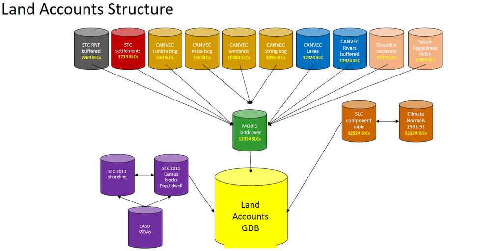
5 Spatial database a central data repository for storage and management of data (QGIS, ESRI ArcGIS) Spatial data - objects defined in a geometric space points (heights of elevation), lines (roads), polygons (land parcels) Applies sophisticated rules and relationships Allows for advanced spatial models to be developed (nearest neighbour and overlay analysis) Keeps spatial data within a consistent, accurate database More importantly integrates spatial data with other databases
6 A spatial database for Land Accounts Allows for diverse land related data available to be integrated using established national frameworks and international level standards and classifications Canada Centre for Remote Sensing land cover classification Environment Canada Ecological classification (Ecozone hierarchy) United Nations System of Environmental-Economic Accounting (SEEA) - Land Cover Classification Reconcile existing publicly available spatial datasets into a common spatial framework Land cover, digital elevation, hydrological spatial data, census socio-economic data Develop and apply new ecosystem accounting concepts Land cover ecosystem unit (LCEU) concept from SEEA, Establish valuation methodologies such as benefit transfer or value transfer when site-specific information is not available Development of indicators i.e. Human landscape modification indicator
) Scientific (role of forest in the carbon cycle, role of energy consumption/production in Greenhouse Gas emissions) As")
7 Why - Local patterns impact national outcomes Information on land provides the basis for policy issues: Environmental (role of wetlands in flood mitigation, filtration of polluted water) Economic (contribution of agriculture, forestry contribution to the economy (GDP)) Scientific (role of forest in the carbon cycle, role of energy consumption/production in Greenhouse Gas emissions) As landscapes change due to human activity; so does its ability to provide Ecosystem goods (EGS) (e.g., fish, timber) and services (e.g., provisioning, production of food, regulating, clean air, productive soil, etc) A geospatial database provides a way to track the quantity, quality and value of land and how human activities impact the environment and the economy in a land account
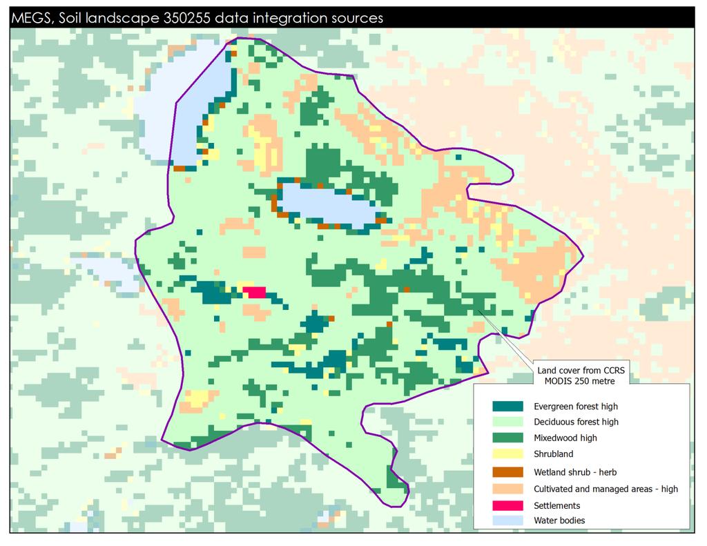
8 Data sources used Dataset Source Type Vintage Canada 250m Land Cover Time Series Natural Resources Canada Land cover CANVEC hydrographic features layer Natural Resources Canada Lakes and rivers 2010 CANVEC wetland features layer Natural Resources Canada Wetlands 2010 Canada Digital Elevation Model Natural Resources Canada Terrain 2000 V2.2 Soil Landscape Units Agriculture and Agri-Food Canada Soil characteristics 2000 Canadian Ecodistrict Climate Normal's Agriculture and Agri-Food Canada Temperature, precipitation Ecozone hierarchy Environment Canada Terrestrial Ecozone framework 2000 Settlement boundaries Statistics Canada Settlements (built up) 2011 Dissemination blocks Statistics Canada Block framework 2011 Road Network File Statistics Canada Road network 2011 Census of Population Statistics Canada Population and dwelling 2011 Census of Agriculture Statistics Canada Agriculture variables 2011
9 9
10 10

11 Results of data integration allows for the creation of a national spatially referenced land account dataset by undertaking a series of overlay analyses and integrating the best possible sources of land data Perform temporal analysis through the integration of socio-economic data from the census of population and agriculture Allow users to query the data at various spatial frameworks (SGC, Ecozone, water sheds) and aggregate that data to a higher reporting unit (i.e. Ecoprovince, CSD, etc.)
 Allows dataset authors to review dataset integration and make recommendations on integrated datasets")

12 The benefits and successes Collaboration and cooperation among dataset authors (DFO, EC), community of practice leads to data discovery and identification Updated using a consistent methodology, concepts, classifications and processes (time series analysis) Allows dataset authors to review dataset integration and make recommendations on integrated datasets Cooperation between various data holders leads to discovery and elimination of duplicate or betterment of datasets Create a public land cover dataset to expand knowledge and usability of land statistics Creation of new datasets, indicators and methodologies for land (Statistics Canada census delineation updates for population centres and land valuation for national accounts policy)
13 Important policy issue for land accounts and Canadians Land accounts for policy provides in a logical manner - where, what and why economy impacts on agriculture loss of dependable agricultural land, food production impacts on forest conversion of forest to agriculture / built-up livability and competitiveness of cities population change, costs for public infrastructure, greenness environment impacts on ecosystems/ biodiversity water / air pollution society Socio-economic issues housing / population characteristics, composition employment and job services accessibility, public health issues


14 Policy uses Educates population and creates awareness on public policy issues: the loss of agricultural land to urban Toronto Greenbelt monitors and characterizes how population growth is changing settlement patterns across the country Human Activity Helps in the development of guidelines and policies to protect environmentally sensitive areas from development Wetlands Inputs into ecosystem goods and services policy Provides additional data for national programs involved collecting socio-economic data Statistics Canada census program 28/09/2017

15 Land Accounts and UN Sustainable Development Goals (SDGs) 2030 SDGs universal, applies to all countries, allows for comparability and reporting When constructing determine if data sources can help with SDG and include into framework Energy / infrastructure land cover, roads, pipelines, etc. Socio-economic area Census data age, sex, income Poverty/education/employment Environment climatic data, forest burns, natural disasters, etc.
16 Lessons learned and things to consider Know your data sources Research datasets and chose best one(s) integration / replacement Get best available data that meets your requirements Strengths / weaknesses of data (measuring what you need) Understand methods and processes used to create data (metadata) Availability of data annual or consistent time period (time series analysis / land cover matrix) Use established and recognized classification system that allows comparison (i.e. SEEA Land cover/use classification) Establish a foundation for reporting framework and spatial extent
17 Lessons learned and things to consider Explore other data sources for more information Collaboration with other data holders, community of best practice Other federal departments (DFO, EC), municipal, provincial, state or private Land Accounts Database Reporting for some land statistics maybe only available at more aggregate reporting units Land cover easily done but need to develop the other components Land potential and land use require new datasets, methodologies and resources Raster data allows for easier processing but not as accurate as vector Raster scale important 1km vs 30m Classification number of classes, comparibility Consider converting raster to vector (more processing / limitations) Additional data usually available in vector format (roads, water features, built-up areas, etc.)
18 Everegreen Forest Deciduous Forest Mixed Forest Disturbance Shrubland Grassland Low Vegetation/Barren Cropland Cropland/Woodland Urban and Built-up Water Snow/ ice Analysis and what can be done with a Land Accounts spatial database Temporal analysis of land cover Annual land cover change matrix Better estimate of changes in forest or agriculture areas (Greenhouse gas estimates) Everegreen Forest 2,455, , ,169 77, , tbd tbd Deciduous Forest 13 31,809 1, tbd tbd Mixed Forest 11,124 2,402 1,084,140 23,526 11, ,495 tbd tbd Disturbance 40, ,374 15,149 15, , tbd tbd 1985 Shrubland 28, ,338 36, , , tbd tbd Grassland , tbd tbd Low Vegetation/Barren 10, ,911 7, ,391, tbd tbd Cropland ,272 3,102 tbd tbd Cropland/Woodland ,326 1, , ,198 tbd tbd Urban and Built-up ,699 tbd Water tbd 1,162,981 tbd Snow/ ice tbd 694,352 Prototype national land indicators Fragmentation of land how has human activity fragmented the land (roads, pipeline/ hydro corridors)recreational values Green space patch size wildlife habitat zones / disruption area and distance between natural landscapes untouched by human activity Better land values for input into national accounts and other industries Canadian Real Estate Board average values (what the value of land is for a given block or area) Insurance purposes areas at risk 2005
19 Finally Think about input/outputs into Land Accounts spatial database rule 80% planning 20% execution Take time to research what is needed and datasets available Provide better tools and base information regarding the land and activities happening on it to develop spatially based policies Use new spatial data developed by public, private and academic organizations to drive policy relevant research
20 Thank you! More information United Nations SEEA land accounts classification - SEEA Central Framework Global Geospatial Information Management - UN-GGIM Statistics Canada Canadian System of Environmental-Economic Accounting - Methodological guide ( X) Ecosystem accounting - Measuring ecosystem goods and services in Canada Human Activity and the Environment - The changing landscape of Canadian metropolitan areas Land cover and land use table (CANSIM ) Analytical articles Human Activity and the Environment ( X) Government of Ontario Land - Ecosystem goods and services 20
Classification of ecosystem types: Experiences and perspectives from Statistics Canada
 Classification of ecosystem types: Experiences and perspectives from Statistics Canada Jennie Wang, François Soulard, Mark Henry, Marcelle Grenier Environmental Accounts and Statistics Program Statistics
06/04/2015. Overview: Spatial units. Advancing the SEEA Experimental Ecosystem Accounting Spatial units (Level 1)
") Advancing the SEEA Experimental Ecosystem Accounting Spatial units (Level 1) Advancing the SEEA-EEA Project Overview: Spatial units 1. Learning objectives 2. Level 1: Presentation & group exercise Spatial
Advancing the SEEA Experimental Ecosystem Accounting Spatial units (Level 1) Advancing the SEEA-EEA Project Overview: Spatial units 1. Learning objectives 2. Level 1: Presentation & group exercise Spatial
Spatial units (Levels 0 and 1)
") Spatial units (Levels 0 and 1) Project: Advancing the SEEA Experimental Ecosystem Accounting Overview: Spatial units 1. Learning objectives 2. Level 1: Presentation & group exercise Spatial units (10m
Spatial units (Levels 0 and 1) Project: Advancing the SEEA Experimental Ecosystem Accounting Overview: Spatial units 1. Learning objectives 2. Level 1: Presentation & group exercise Spatial units (10m
Land Accounts in Canada
 Land Accounts in Canada 22 nd meeting of the London Group September 29 th, 2016 Statistics Norway, Oslo Gabriel Gagnon Statistics Canada Land accounts in Canada OVERVIEW Context Strategic direction Latest
Measuring ecosystems and biodiversity and related goods and services
 Measuring ecosystems and biodiversity and related goods and services World Bank, WAVES Partnership Meeting Michael Bordt, EASD Statistics Canada March 30, 2011 Outline What exists already in Canada and
KENYA NATIONAL BUREAU OF STATISTICS Workshop on
 KENYA NATIONAL BUREAU OF STATISTICS Workshop on Capacity Building in Environment Statistics: the Framework for the Development of Environment Statistics (FDES 2013) Coordination with Sector Ministries
SEEA Experimental Ecosystem Accounting
 SEEA Experimental Ecosystem Accounting Sokol Vako United Nations Statistics Division Training for the worldwide implementation of the System of Environmental Economic Accounting 2012 - Central Framework
Land Accounting. Sub-regional Workshop on Environment Statistics for South and South-West Asian Countries. Michael Bordt ESCAP
 Land Accounting Michael Bordt ESCAP bordt@un.org Sub-regional Workshop on Environment Statistics for South and South-West Asian Countries Feb. 6-8, 2017 Bangkok, Thailand Overview: Land Accounting Learning
Data sources and classification for ecosystem accounting g
 Data sources and classification for ecosystem accounting Ken Bagstad 23 February 2015 Wealth Accounting and the Valuation of Ecosystem Services www.wavespartnership.org Data sources and classification
Extent. Level 1 and 2. October 2017
 Extent Level 1 and 2 October 2017 Overview: Extent account 1. Learning objectives 2. Review of Level 0 (5m) 3. Level 1 (Compilers): Concepts (15m) Group exercise and discussion (15m) 4. Level 2 (Data Providers)
Spatial Units (Level 1)
") Spatial Units (Level 1) Project: Advancing the SEEA Experimental Ecosystem Accounting Overview: Spatial Units 1. Learning objectives 2. Review of Level 0 (5m) 3. Level 1 (Compilers): Presentation & group
Spatial Units (Level 1) Project: Advancing the SEEA Experimental Ecosystem Accounting Overview: Spatial Units 1. Learning objectives 2. Review of Level 0 (5m) 3. Level 1 (Compilers): Presentation & group
Developing urban ecosystem accounts for Great Britain. Emily Connors Head of Natural Capital Accounting Office for National Statistics (UK)
") Developing urban ecosystem accounts for Great Britain Emily Connors Head of Natural Capital Accounting Office for National Statistics (UK) UN 2014 UN 2014 ONS 2017 UK motivation 54% 82% 5,900 Of the world
Developing urban ecosystem accounts for Great Britain Emily Connors Head of Natural Capital Accounting Office for National Statistics (UK) UN 2014 UN 2014 ONS 2017 UK motivation 54% 82% 5,900 Of the world
A Method for Mapping Settlement Area Boundaries in the Greater Golden Horseshoe
 A Method for Mapping Settlement Area Boundaries in the Greater Golden Horseshoe Purpose This paper describes a method for mapping and measuring the lands designated for growth and urban expansion in the
ENV208/ENV508 Applied GIS. Week 1: What is GIS?
 ENV208/ENV508 Applied GIS Week 1: What is GIS? 1 WHAT IS GIS? A GIS integrates hardware, software, and data for capturing, managing, analyzing, and displaying all forms of geographically referenced information.
Foundation Geospatial Information to serve National and Global Priorities
 Foundation Geospatial Information to serve National and Global Priorities Greg Scott Inter-Regional Advisor Global Geospatial Information Management United Nations Statistics Division UN-GGIM: A global
Observation (EO) & Geomatics in Canada
 & Geomatics in Canada") Innovating to Increase the Impact of Earth Observation (EO) & Geomatics in Canada Natural Resources Canada February 25, 2014 Prashant Shukle, Director General Canada Centre for Mapping and Earth Observation
Innovating to Increase the Impact of Earth Observation (EO) & Geomatics in Canada Natural Resources Canada February 25, 2014 Prashant Shukle, Director General Canada Centre for Mapping and Earth Observation
Land Use in the context of sustainable, smart and inclusive growth
 Land Use in the context of sustainable, smart and inclusive growth François Salgé Ministry of sustainable development France facilitator EUROGI vice president AFIGéO board member 1 Introduction e-content+
Land accounting in Québec: Pilot project for a sub-provincial area
 Land accounting in Québec: Pilot project for a sub-provincial area Stéphanie Uhde 8th meeting of the London Group on Environmental Accounting Ottawa, 2 October, 2012 Province of Québec Area: 1 667 441
System of Environmental-Economic Accounting. Advancing the SEEA Experimental Ecosystem Accounting. Extent Account (Levels 1 and 2)
") Advancing the SEEA Experimental Ecosystem Accounting Extent Account (Levels 1 and 2) Overview: The Extent Account 1. Learning objectives 2. Review of Level 0 (5m) What is it? Why do we need it? What does
Advancing the SEEA Experimental Ecosystem Accounting Extent Account (Levels 1 and 2) Overview: The Extent Account 1. Learning objectives 2. Review of Level 0 (5m) What is it? Why do we need it? What does
Fig 1. Steps in the EcoValue Project
 Assessing the Social and Economic Value of Ecosystem Services in the Northern Forest Region: A Geographic Information System (GIS) Approach to Landscape Valuation Principal Investigator(s): Dr. Matthew
Compact guides GISCO. Geographic information system of the Commission
 Compact guides GISCO Geographic information system of the Commission What is GISCO? GISCO, the Geographic Information System of the COmmission, is a permanent service of Eurostat that fulfils the requirements
The Federal Geospatial Platform (FGP) and Open Maps Canada. Eric Loubier, Director Natural Resources Canada Earth Sciences Sector
 and Open Maps Canada. Eric Loubier, Director Natural Resources Canada Earth Sciences Sector") The Federal Geospatial Platform (FGP) and Open Maps Canada Eric Loubier, Director Natural Resources Canada Earth Sciences Sector May 2016 Geospatial data are produced and widely used in the federal government
The Federal Geospatial Platform (FGP) and Open Maps Canada Eric Loubier, Director Natural Resources Canada Earth Sciences Sector May 2016 Geospatial data are produced and widely used in the federal government
Update ecosystem services analysis in SEEA Experimental Ecosystem Accounting
 Update ecosystem services analysis in SEEA Experimental Ecosystem Accounting Prof. Dr Lars Hein, Wageningen University With materials produced by or in collaboration with CBS, Statistics the Netherlands
Summary Description Municipality of Anchorage. Anchorage Coastal Resource Atlas Project
 Summary Description Municipality of Anchorage Anchorage Coastal Resource Atlas Project By: Thede Tobish, MOA Planner; and Charlie Barnwell, MOA GIS Manager Introduction Local governments often struggle
FDES: Chapter 1. Overview of Environment Statistics Characteristics and Challenges. FDES: Framework for the Development of Environment Statistics
 FDES: Chapter 1 Overview of Environment Statistics Characteristics and Challenges FDES: Framework for the Development of Environment Statistics 6. 2. Environment Environmental Protection, Resources and
Ecological Land Cover Classification For a Natural Resources Inventory in the Kansas City Region, USA
 Ecological Land Cover Classification For a Natural Resources Inventory in the Kansas City Region, USA by Applied Ecological Services, Inc. In cooperation with the Mid-America Regional Council 600 Broadway,
Economic Benefit Study on Value of Spatial Information Australian Experience
 Economic Benefit Study on Value of Spatial Information Australian Experience Dr Zaffar Sadiq Mohamed-Ghouse Director, International Relations Cooperative Research Centre for Spatial Information zsadiq@crcsi.com.au
Plan4all (econtentplus project)
") Plan4all (econtentplus project) Karel CHARVAT 1, Tomáš MILDORF 2 1 Help service remote sensing, Ltd., Černoleská 1600, 256 01 Benešov u Prahy, Czech Republic charvat@bnhelp.cz 2 Department of Mathematics
Plan4all (econtentplus project) Karel CHARVAT 1, Tomáš MILDORF 2 1 Help service remote sensing, Ltd., Černoleská 1600, 256 01 Benešov u Prahy, Czech Republic charvat@bnhelp.cz 2 Department of Mathematics
Mapping and Assessment of Ecosystems and their Services
 Mapping and Assessment of Ecosystems and their Services ALTER-Net Conference 2013: Science underpinning the EU 2020 Biodiversity Strategy. April 2013 Gent Joachim MAES 1 This presentation is based on the
Spatial Units, Scaling and Aggregation (Level 1) October 2017
 October 2017") Spatial Units, Scaling and Aggregation (Level 1) October 2017 Overview: Spatial Units 1. Learning objectives 2. Review of Level 0 (5m) 3. Level 1 (Compilers): Presentation & group exercise Spatial units
Spatial Units, Scaling and Aggregation (Level 1) October 2017 Overview: Spatial Units 1. Learning objectives 2. Review of Level 0 (5m) 3. Level 1 (Compilers): Presentation & group exercise Spatial units
TOWARDS CLIMATE-RESILIENT COASTAL MANAGEMENT: OPPORTUNITIES FOR IMPROVED ICZM IN BELIZE
 TOWARDS CLIMATE-RESILIENT COASTAL MANAGEMENT: OPPORTUNITIES FOR IMPROVED ICZM IN BELIZE CHANTALLE SAMUELS Coastal Zone Management Authority and Institute The Caribbean Community Climate Change Centre VULNERABILITY
Techniques for Science Teachers: Using GIS in Science Classrooms.
 Techniques for Science Teachers: Using GIS in Science Classrooms. After ESRI, 2008 GIS A Geographic Information System A collection of computer hardware, software, and geographic data used together for
Framework for the Basin-Wide Socio-Economic Analysis of Four Proposed Sediment Diversions. August 4, 2015
 Framework for the Basin-Wide Socio-Economic Analysis of Four Proposed Sediment Diversions August 4, 2015 Proposed Sediment Diversions Mid-Breton Mid-Barataria Lower Barataria Lower Breton Overview of Presentation
Impact Policies Enabling Value Enhancement of Geospatial Information in Canadian Economy and Society
 1 Impact Policies Enabling Value Enhancement of Geospatial Information in Canadian Economy and Society May 26, 2015 Prashant Shukle, Director General Canada Centre for Mapping and Earth Observation Increased
Integration for Informed Decision Making
 Geospatial and Statistics Policy Intervention: Integration for Informed Decision Making Greg Scott Global Geospatial Information Management United Nations Statistics Division Department of Economic and
STEREO ANALYST FOR ERDAS IMAGINE Stereo Feature Collection for the GIS Professional
 STEREO ANALYST FOR ERDAS IMAGINE Stereo Feature Collection for the GIS Professional STEREO ANALYST FOR ERDAS IMAGINE Has Your GIS Gone Flat? Hexagon Geospatial takes three-dimensional geographic imaging
Disaster Management & Recovery Framework: The Surveyors Response
 Disaster Management & Recovery Framework: The Surveyors Response Greg Scott Inter-Regional Advisor Global Geospatial Information Management United Nations Statistics Division Department of Economic and
Statistical-geospatial integration - The example of Sweden. Marie Haldorson Director, Statistics Sweden
 Statistical-geospatial integration - The example of Sweden Marie Haldorson Director, Statistics Sweden Spatial data and geospatial applications at Statistics Sweden Long tradition GI integrated in production
Systems (GIS) - with a focus on.
 - with a focus on.") Introduction to Geographic Information Systems (GIS) - with a focus on localizing the MDGs Carmelle J. Terborgh, Ph.D. ESRI www.esri.com Flying Blind Jul 24th 2003 The Economist We Live in Two Worlds Natural
Introduction to Geographic Information Systems (GIS) - with a focus on localizing the MDGs Carmelle J. Terborgh, Ph.D. ESRI www.esri.com Flying Blind Jul 24th 2003 The Economist We Live in Two Worlds Natural
Work Group A «Core Data» Report and Update François Chirié, Dominique Laurent, France
 JOINT UN-GGIM: EUROPE ESS MEETING ON THE INTEGRATION OF STATISTICAL AND GEOSPATIAL INFORMATION LUXEMBOURG 11 MARCH 2016 Work Group A «Core Data» Report and Update François Chirié, Dominique Laurent, France
CHAPTER 4 HIGH LEVEL SPATIAL DEVELOPMENT FRAMEWORK (SDF) Page 95
 Page 95") CHAPTER 4 HIGH LEVEL SPATIAL DEVELOPMENT FRAMEWORK (SDF) Page 95 CHAPTER 4 HIGH LEVEL SPATIAL DEVELOPMENT FRAMEWORK 4.1 INTRODUCTION This chapter provides a high level overview of George Municipality s
CHAPTER 4 HIGH LEVEL SPATIAL DEVELOPMENT FRAMEWORK (SDF) Page 95 CHAPTER 4 HIGH LEVEL SPATIAL DEVELOPMENT FRAMEWORK 4.1 INTRODUCTION This chapter provides a high level overview of George Municipality s
Accounting for Ecosystem and Biodiversity Related Themes in Uganda
 Introduction Accounting for Ecosystem and Biodiversity Related Themes in Uganda Calls for more evidence-based approaches to policy have increased the need for integrated environmental-economic information
The Global Fundamental Geospatial Data Themes Journey. April Clare Hadley WG Chair
 The Global Fundamental Geospatial Data Themes Journey April 2018 Clare Hadley WG Chair The Road to here Why Global? Why Geospatial? Why Fundamental? Why Themes? The route we took Where does the road go
16540/14 EE/cm 1 DG E 1A
 Council of the European Union Brussels, 5 December 2014 (OR. en) 16540/14 ENV 965 CULT 139 NOTE From: To: Subject: General Secretariat of the Council Delegations Charter of Rome on Natural and Cultural
Exploring GIS Potential for Northwestern Ontario Land Information Ontario
 Exploring GIS Potential for Northwestern Ontario Land Information Ontario May 13, 2015 The LIO Vision LIO Vision: That all geographic information about Ontario is fully integrated and accessible LIO Goal:
FUNDAMENTALS OF GEOINFORMATICS PART-II (CLASS: FYBSc SEM- II)
") FUNDAMENTALS OF GEOINFORMATICS PART-II (CLASS: FYBSc SEM- II) UNIT:-I: INTRODUCTION TO GIS 1.1.Definition, Potential of GIS, Concept of Space and Time 1.2.Components of GIS, Evolution/Origin and Objectives
FUNDAMENTALS OF GEOINFORMATICS PART-II (CLASS: FYBSc SEM- II) UNIT:-I: INTRODUCTION TO GIS 1.1.Definition, Potential of GIS, Concept of Space and Time 1.2.Components of GIS, Evolution/Origin and Objectives
Through their research, geographers gather a great deal of data about Canada.
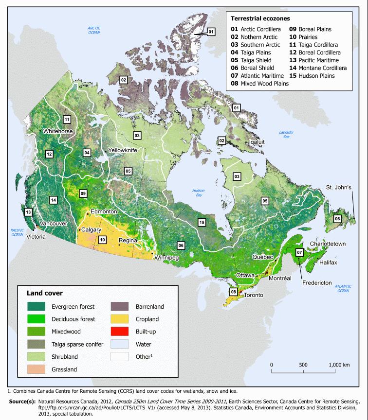
 Ecozones What is an Ecozone? Through their research, geographers gather a great deal of data about Canada. To make sense of this information, they often organize and group areas with similar features.
THE ROLE OF GEOSPATIAL AT THE WORLD BANK
 THE ROLE OF GEOSPATIAL AT THE WORLD BANK INSPIRE Conference Barcelona, Spain September 26, 2016 Kathrine Kelm Senior Land Administration Specialist Global Land and Geospatial Unit The World Bank Group
Ecosystem Accounting in Canada
 Ecosystem Accounting in Canada François Soulard Environment, Energy and Transportation Statistics Division Statistics Canada A Community on Ecosystem Services: Linking Science, Practice and Decision Making
International Guidelines on Access to Basic Services for All
 International Guidelines on Access to Basic Services for All Presentation and initials lessons from implementation Accessibility to services in regions and cities : measures and policies, OECD 18 June
GIS = Geographic Information Systems;
 What is GIS GIS = Geographic Information Systems; What Information are we talking about? Information about anything that has a place (e.g. locations of features, address of people) on Earth s surface,
Global Geospatial Information Management Country Report Finland. Submitted by Director General Jarmo Ratia, National Land Survey
 Global Geospatial Information Management Country Report Finland Submitted by Director General Jarmo Ratia, National Land Survey Global Geospatial Information Management Country Report Finland Background
Copernicus Overview. Major Emergency Management Conference Athlone 2017
 Copernicus Overview Major Emergency Management Conference Athlone 2017 Copernicus is a European programme implemented by the European Commission. The services address six thematic areas: land, marine,
EcoServ-GIS. EcoServ GIS Stage I. Why EcoServ GIS? 17/12/2012
 EcoServ-GIS Ecosystem Services Mapping: A Wildlife Trust GIS Toolkit to map ecosystem services at a county scale Dr Jonathan Winn Living Landscape Coordinator Durham Wildlife Trust Dr Chloe Bellamy Ecosystem
Introduction. Elevation Data Strategy. Status and Next Steps
 1 2 Introduction Elevation Data Strategy Status and Next Steps 3 Canada is the 2nd largest country in the world - 9.9 million sq km Surrounded by 3 oceans with 202 000 km of coastline Population over 35
Maria Andrzejewska UNEP/GRID Warsaw Centre
 Maria Andrzejewska UNEP/GRID Warsaw Centre Agenda 1. Environment matters! 2. Spatial data to benefit environment 3. Environment management with cadastral data 4. Cadaster in spatial planning 5. Conclusions
NCAVES - Global initiative and national pilots
 NCAVES - Global initiative and national pilots Kavita Sharma UN Environment Pretoria, March 2018 Outline 1. Global initiative > Introduction > Objectives and deliverables >Activities in 2017 and 2018 2.
The UN-GGIM: Europe core data initiative to encourage Geographic information supporting Sustainable Development Goals Dominique Laurent, France
 INSPIRE conference Strasbourg 6 September 2017 The UN-GGIM: Europe core data initiative to encourage Geographic information supporting Sustainable Development Goals Dominique Laurent, France Introduction
Date: June 19, 2013 Meeting Date: July 5, Consideration of the City of Vancouver s Regional Context Statement
 Section E 1.5 To: From: Regional Planning and Agriculture Committee Lee-Ann Garnett, Senior Regional Planner Planning, Policy and Environment Department Date: June 19, 2013 Meeting Date: July 5, 2013 Subject:
A Comprehensive Inventory of the Number of Modified Stream Channels in the State of Minnesota. Data, Information and Knowledge Management.
 A Comprehensive Inventory of the Number of Modified Stream Channels in the State of Minnesota Data, Information and Knowledge Management Glenn Skuta Environmental Analysis and Outcomes Division Minnesota
Most people used to live like this
 Urbanization Most people used to live like this Increasingly people live like this. For the first time in history, there are now more urban residents than rural residents. Land Cover & Land Use Land cover
Plenary Session 2, part 2 A European shared information system
 3 rd GMES Forum 5 6 June 2003 Athens Plenary Session 2, part 2 A European shared information system Gordon McInnes Deputy Director European Environment Agency 1 I keep six honest serving men. They taught
Spanish national plan for land observation: new collaborative production system in Europe
 ADVANCE UNEDITED VERSION UNITED NATIONS E/CONF.103/5/Add.1 Economic and Social Affairs 9 July 2013 Tenth United Nations Regional Cartographic Conference for the Americas New York, 19-23, August 2013 Item
EBA Engineering Consultants Ltd. Creating and Delivering Better Solutions
 EBA Engineering Consultants Ltd. Creating and Delivering Better Solutions ENHANCING THE CAPABILITY OF ECOSYSTEM MAPPING TO SUPPORT ADAPTIVE FOREST MANAGEMENT Prepared by: EBA ENGINEERING CONSULTANTS LTD.
Sustainable and Harmonised Development for Smart Cities The Role of Geospatial Reference Data. Peter Creuzer
 Sustainable and Harmonised Development for Smart Cities The Role of Geospatial Reference Data Peter Creuzer 1. Introduction - Smart Cities and Geodata 2. Geodata in Germany 3. Examples 4. Data and Service
CERTIFIED RESOLUTION. introduction: and dated May 29, 2017, as attached, as appropriate
 15322 Buena Vista Avenue, White Rock BC, Canada V4B 1Y6 www.whiterockcity.ca City of White Rock P: 604.541.22121 F: 604.541.9348 /2tC% City Clerk s Office IT E ROC K June 13,2017 Stephanie Lam, Deputy
a national geological survey perspective François ROBIDA BRGM (French Geological Survey)
") a national geological survey perspective François ROBIDA BRGM (French Geological Survey) Pre-Conference Seminar on Socio-Economic Value of Geospatial for National and Regional Development 21 August 2017,
a national geological survey perspective François ROBIDA BRGM (French Geological Survey) Pre-Conference Seminar on Socio-Economic Value of Geospatial for National and Regional Development 21 August 2017,
Outline National legislative & policy context Regional history with ESSIM ESSIM Evaluation Phase Government Integration via RCCOM Regional ICOM Framew
 What MSP Implementation could change in the Maritimes Region Tim Hall, Regional Manager Oceans and Coastal Management Division Ecosystem Management Branch Fisheries and Oceans Canada Maritimes Region BIO
Chapter 6. Fundamentals of GIS-Based Data Analysis for Decision Support. Table 6.1. Spatial Data Transformations by Geospatial Data Types
 Chapter 6 Fundamentals of GIS-Based Data Analysis for Decision Support FROM: Points Lines Polygons Fields Table 6.1. Spatial Data Transformations by Geospatial Data Types TO: Points Lines Polygons Fields
An Update on Land Use & Land Cover Mapping in Ireland
 An Update on Land Use & Land Cover Mapping in Ireland Progress Towards a National Programme Kevin Lydon k.lydon@epa.ie Office of Environmental Assessment, Environmental Protection Agency, Johnstown Castle,
Land Cover Classification Mapping & its uses for Planning
 Land Cover Classification Mapping & its uses for Planning What is Land Cover Classification Mapping? Examples of an actual product Why use Land Cover Classification Mapping for planning? Possible uses
USGS Hydrography Overview. May 9, 2018
 + 1 USGS Hydrography Overview May 9, 2018 + 2 The National Geospatial Program Provides the geospatial baseline of the Nation s topography, natural landscape and built environment through The National Map,
Physical Geography: Patterns, Processes, and Interactions, Grade 11, University/College Expectations
 Geographic Foundations: Space and Systems SSV.01 explain major theories of the origin and internal structure of the earth; Page 1 SSV.02 demonstrate an understanding of the principal features of the earth
TEEB: The Economics of Ecosystems and Biodiversity Overview of Process, Content and Approach
 TEEB: The Economics of Ecosystems and Biodiversity Overview of Process, Content and Approach Heidi Wittmer TEEBAgriFood writers workshop Paris, 9-10 May 2016 TEEB s genesis Potsdam Initiative Biological
Qatar Statistical Geospatial Integration
 Qatar Statistical Geospatial Integration A Presentation by the Ministry of Development Planning & Statistics (MDPS), State of Qatar http://www.mdps.gov.qa (Fourth UN-GGIM Arab States Committee Meeting,
Georeferencing and Satellite Image Support: Lessons learned, Challenges and Opportunities
 Georeferencing and Satellite Image Support: Lessons learned, Challenges and Opportunities Shirish Ravan shirish.ravan@unoosa.org UN-SPIDER United Nations Office for Outer Space Affairs (UNOOSA) UN-SPIDER
National Adaptation Geo-information System (NAGiS) project in Hungary
 project in Hungary") National Adaptation Geo-information System (NAGiS) project in Hungary Mr. Péter Kajner Hungarian Mining and Geological Survey (MBFSZ) National Adaptation Center Department CGE webinar: Geo-information
National Adaptation Geo-information System (NAGiS) project in Hungary Mr. Péter Kajner Hungarian Mining and Geological Survey (MBFSZ) National Adaptation Center Department CGE webinar: Geo-information
Regional Plan 4: Integrating Ecosystem Services Mapping into Regional Land Use Planning
 Rural-Urban Outlooks: Unlocking Synergies (ROBUST) ROBUST receives funding from the European Union s Horizon 2020 research and innovation programme under grant agreement No 727988.* October 2018 Natural
Minnesota K-12 Academic Standards in Social Studies. Grade 4: Geography of North America
 Minnesota K-12 Academic s in Social Studies Grade 4: Geography of North America 4 Describe how people take 1. Democratic government action to influence a depends on informed and decision on a specific
Chapter : 1 : Introduction of GIS
 History of GIS : Chapter : 1 : Introduction of GIS In 1960 the Department of Forestry and Rural Department of Canada has decided to pursue a large-scale project to manage the resources. The initial task
Economic and Social Council
 United Nations Economic and Social Council Distr.: General 2 July 2012 E/C.20/2012/10/Add.1 Original: English Committee of Experts on Global Geospatial Information Management Second session New York, 13-15
Accounting Units for Ecosystem Accounts Paper prepared by Alessandra Alfieri, Daniel Clarke, and Ivo Havinga United Nations Statistics Division
 DEPARTMENT OF ECONOMIC AND SOCIAL AFFAIRS STATISTICS DIVISION UNITED NATIONS Expert Meeting on Ecosystem Accounts London, UK 5-7 December 2011 Accounting Units for Ecosystem Accounts Paper prepared by
ISO Canadian Drought Monitor Data Product Specifications
 ISO 19131 Canadian Drought Monitor Data Product Specifications Revision: A Page 1 of 14 Data product specifications: Canadian Drought Monitor - Table of Contents- 1. Overview... 3 1.1. Informal description...
Automated GIS routine for Strategic Environmental Assessment: a spatiotemporal analysis of urban and wetland change
 Automated GIS routine for Strategic Environmental Assessment: a spatiotemporal analysis of urban and wetland change Anton Sizo 1, Scott Bell 2, and Bram Noble 3 1 Geography and Planning, University of
2 nd Semester. Core Courses. C 2.1 City and Metropolitan Planning. Module 1: Urban Structure and Growth Implications
 2 nd Semester Core Courses C 2.1 City and Metropolitan Planning Module 1: Urban Structure and Growth Implications Growth of cities; cities as engine of growth; urban sprawl; land value, economic attributes
INSPIRE Basics. Vlado Cetl European Commission Joint Research Centre. https://ec.europa.eu/jrc/
 INSPIRE Basics Vlado Cetl European Commission Joint Research Centre https://ec.europa.eu/jrc/ Serving society Stimulating innovation Supporting legislation Outline SDI? Why European SDI? INSPIRE Policy
Geospatial Policy Development and Institutional Arrangements *
 HIGH LEVEL FORUM ON GLOBAL GEOSPATIAL MANAGEMENT INFORMATION WORKING PAPER No. 13 First Forum Seoul, Republic of Korea, 24-26 October 2011 Geospatial Policy Development and Institutional Arrangements *
Urbanization and Sustainable Development of Cities: A Ready Engine to Promote Economic Growth and Cooperation
 Urbanization and Sustainable Development of Cities: A Ready Engine to Promote Economic Growth and Cooperation Wan Portia Hamzah Institute of Strategic and International Studies (ISIS) Malaysia 10 September
EcoServ-GIS. Ecosystem Services Mapping: A Wildlife Trust GIS Toolkit to map ecosystem services at a county scale
 EcoServ-GIS Ecosystem Services Mapping: A Wildlife Trust GIS Toolkit to map ecosystem services at a county scale Dr Jonathan Winn Living Landscape Coordinator Durham Wildlife Trust Dr Chloe Bellamy Ecosystem
Use of Geospatial data for disaster managements
 Use of Geospatial data for disaster managements Source: http://alertsystemsgroup.com Instructor : Professor Dr. Yuji Murayama Teaching Assistant : Manjula Ranagalage What is GIS? A powerful set of tools
Calculating Land Values by Using Advanced Statistical Approaches in Pendik
 Presented at the FIG Congress 2018, May 6-11, 2018 in Istanbul, Turkey Calculating Land Values by Using Advanced Statistical Approaches in Pendik Prof. Dr. Arif Cagdas AYDINOGLU Ress. Asst. Rabia BOVKIR
Creating synergies between Statistical and Geospatial information for better policy outputs: The case of Mexico
 Creating synergies between Statistical and Geospatial information for better policy outputs: The case of Mexico Geospatial & Statistics Integration for Informed Decision Making Geospatial World Forum 2017
MANUAL ON THE BSES: LAND USE/LAND COVER
 6. Environment Protection, Management and Engagement 2. Environmental Resources and their Use 5. Human Habitat and Environmental Health 1. Environmental Conditions and Quality 4. Disasters and Extreme
Developing a global, peoplebased definition of cities and settlements
 Developing a global, peoplebased definition of cities and settlements By Lewis Dijkstra, Lewis.Dijkstra@ec.europa.eu Head of the Economic Analysis Sector DG for Regional and Urban Policy, Regional & Urban
Key Indicators for Territorial Cohesion & Spatial Planning Stakeholder Workshop - Project Update. 13 th December 2012 San Sebastián, Basque Country
 Key Indicators for Territorial Cohesion & Spatial Planning Stakeholder Workshop - Project Update 13 th December 2012 San Sebastián, Basque Country Key Aims Explore the use of territorial data in developing
GIS Geographical Information Systems. GIS Management
 GIS Geographical Information Systems GIS Management Difficulties on establishing a GIS Funding GIS Determining Project Standards Data Gathering Map Development Recruiting GIS Professionals Educating Staff
SUPPORTS SUSTAINABLE GROWTH
 DDSS BBUUN NDDLLEE G E O S P AT I A L G O V E R N A N C E P A C K A G E SUPPORTS SUSTAINABLE GROWTH www.digitalglobe.com BRISBANE, AUSTRALIA WORLDVIEW-3 30 CM International Civil Government Programs US
Realizing benefits of Spatial Data Infrastructure A user s perspective from Environment Agency - Abu Dhabi
 Realizing benefits of Spatial Data Infrastructure A user s perspective from Environment Agency - Abu Dhabi Anil Kumar Director, Environment Information Management 26 April 2012 Geospatial World Forum,
Introduction to GIS. Dr. M.S. Ganesh Prasad
 Introduction to GIS Dr. M.S. Ganesh Prasad Department of Civil Engineering The National Institute of Engineering, MYSORE ganeshprasad.nie@gmail.com 9449153758 Geographic Information System (GIS) Information
Assessment and valuation of Ecosystem Services for decision-makers
 Assessment and valuation of Ecosystem Services for decision-makers An introduction to the ARIES approach Ferdinando Villa *, Ken Bagstad Gary Johnson, Marta Ceroni *Basque Center for Climate Change, Bilbao,