Urban remote sensing: from local to global and back
|
|
|
- Antony Spencer Rich
- 5 years ago
- Views:
Transcription


1 Urban remote sensing: from local to global and back Paolo Gamba University of Pavia, Italy


2 A few words about Pavia Historical University (1361) in a nice town


3 slide 3 Geoscience and Remote Sensing Society

4 Geoscience and Remote Sensing Society
5 Geoscience and Remote Sensing Society
6 Outline A brief introduction to urban mapping at the country level Challenges for urban mapping at the national scale National urban mapping using Landsat data National urban mapping applications Conclusions and further work
7 Why global urban area maps? According to the United Nations, cities occupy around 2% of the total land, however 7


, the single urban")
8 Spatial resolution and urban areas Using free satellite imagery ground spatial resolution on the order of 500 to 30 m are achievable, and continental/regional analyses may be performed. Using multispectral satellites at high resolution (from 10 to 2.5 m posting) we may work on the single town scale and the urban environments. Finally, with Very High Resolution satellites (1 m or less), the single urban element (a building, a street,...) may be individuated and studied.


9 National-level remote sensing A global view of urban areas may be useful to understand the processes behind urbanization. Trends for land use transformation must be monitored, forecasted and controlled to prevent the degradation of the environment. Economic variable collected nation-wide can be spatially disaggregated using urban areas as proxies (population, industrial/commercial activities, pollution sources, )


10 URS at town scale At town scale, urban remote sensing may improve the understanding of the town structure, characterizing blocks and changing patterns of land cover/land use. Environmental models at urban scale are increasingly requiring geographically distributed inputs, available using current satellite systems.


11 VHR Urban Remote Sensing At the most detailed scale, many analysis are possible at the feature level, e.g. buildings, roads, other artificial structures: detecting and modeling these structure for generic location-based service use; Characterizing the three dimensional structure of the urban landscape and providing more sophisticated added value products.
 P.")
12 A multiscale fusion problem For urban areas, multiple spatial scale of analysis must be used, and information at each of these scales reconciled so that features extracted at one scale match with their generalization at coarse scales and, at the same time, help infer more refined features at finer spatial resolution(s) P. Gamba, Human settlements: a global challenge for EO data processing and interpretation, Proceedings of IEEE, doi: /JPROC

13 First challenge: scale
14 Second challenge: diversity

15 Third challenge: sparsity
16 Fourth challenge: data availability
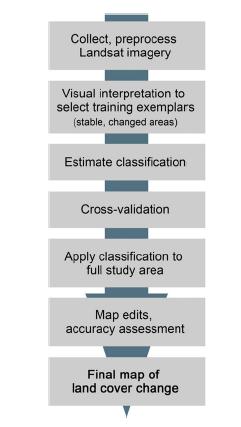
17 Fifth challenge: processing


18 Let s focus on urban areas
19 Landsat archives & Sentinel data Landsat archives cover a long time span, and the whole globe. The Sentinel constellation by ESA is going to complement it Landsat spatial resolution (30 m) may coarse for detailed urban applications, but their granularity and continuity in time is ideal for urban development mapping. The usual approach to capture global maps from multispectral data is the use of indexes (e.g., NDVI, NDSI, ), but each index captures only one specific material. Thus, we need something different, able to cope with other challenges, such as: collected radiances change with seasons and weather conditions; spectral properties of urban materials are not consistent on wide geographic areas; urban material are extremely various even within the same urban area.

/(B i")


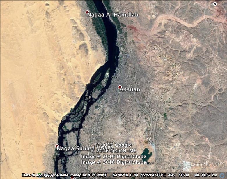
20 The whole procedure Selection of a Landsat scene Selection (and combination) of multiple scenes NDSV computation NDSV ij = (B i -B j )/(B i +B j ) Classification using single or multiple classifiers Wide area classification by combing multiple training sets Spatial regularization Multitemporal map comparison
 of")


21 NDSV Selection of a Landsat scene Selection (and combination) of multiple scenes forest agricultural fields NDSV computation Classification using single or multiple classifiers Wide area classification by combing multiple training sets Spatial regularization Multitemporal map comparison urban water
 of multiple scenes NDSV")


22 Multiple classifiers Selection of a Landsat scene Selection (and combination) of multiple scenes NDSV computation Classification using single or multiple classifiers Wide area classification by combing multiple training sets Spatial regularization Multitemporal map comparison Classif. Classif. Classif. Classif. Classif. Map

23 Sao Paulo: (Multiple) classifier(s) Manual GT INPE
 GEE: morphological filtering adapted to the mapping scale Morphologi cal opening (erosion + dilation) Structuring element")
24 Spatial regularization Selection of a Landsat scene Classification using single or multiple classifiers Spatial regularization NDSV computation Selection (and combination) of multiple scenes Wide area classification by combing multiple training sets Multitemporal map comparison Per-pixel classifiers are prone to salt and pepper noise Standard approach is using spatial regularization (e.g., MRF) GEE: morphological filtering adapted to the mapping scale Morphologi cal opening (erosion + dilation) Structuring element

25 Regularization via morphology
 of multiple")


26 Multi-temporal data sets Selection of a Landsat scene Selection (and combination) of multiple scenes Classif. Map NDSV computation Classification using single or multiple classifiers Wide area classification by combing multiple training sets Classif. Map Spatial regularization Multitemporal map comparison


27 At least one year for cloudy skies One year collection versus a combination of quarterly collections
28 Median/Composite/Greenest Median: collections obtained by considering all scenes on a give area and assigning to the final image the median (more probable) value: good idea to reduce clouds, but it does not work always. A decision level fusion is required. Composite: collections where a cloud score is computed to assess the quality of each scene and aggregate cloud-free pixels from multiple images: slightly better than median filter at reducing cloud cover; slightly worse at the radiometry of the scene; more or less same classification accuracy Greenest: pre-computed yearly collections where the pixel value is selected from the scene where that pixels has the highest NDVI value.


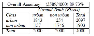
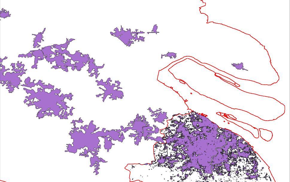
29 Results: JiangSu province Multiple classifiers and no post-classification Landsat GT VHR GT:

30 Results: Istanbul
31 What is this for? Wide area Global (risk, population, exposure, economic, ) analysis Single date Multitemporal analysis (past trends, future developments, ) Finer spatial resolution more details than existing maps

32 Better time granularity
33 More details

34 New 30 grid


35 Application: population mapping Aggregate Census Blocks to One Administrative Unit Up Process Census Data and Create 10 km Buffered Covariate Boundary, Conformal Projection Extract Vector-Based Covariate Data by Buffered Census Boundary From VMAP0/1 Project and Resample/Aggregate Other Raster Data to Match Census Buffer Rasterize Vector Data, Matching Gridded Census Buffer Supplement or Replace Base Data With Improved Sources Create Distance-To Rasters For Rasterized Point, Line and Binary Class-Based Raster Covariates Aggregate Covariates by Census Blocks and Estimate Random Forest Model Predict Per-Pixel Population Density With Random Forest Algorithm Stevens, F.R., Gaughan, A.E., Linard, C., and A.J. Tatem. Disaggregating census data for population mapping using Random Forests with remotely-sensed and other ancillary data. In Review: Plosone Aggregate Per-Pixel Population to Finer Level Administrative Units and Compare To Afri/AsiaPop GRUMP/GPW Project Population Density Prediction Grid and Redistribute Census Block Totals Weighted by Predictions
 500 8 0.29 81 MDA+MODIS 500 m (2010) 500 6 0.26 83 MDA+GEE (2009) 500 9 0.")
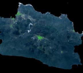
36 Results: the island of Java Landcover Types Number of Trees (RF) #Variables Mean of Squared Residuals % of Variance Explained MDA (2007, Imagery from 2005) MDA+MODIS 500 m (2010) MDA+GEE (2009)

37 Population change maps
38 Conclusions Remote sensing at the national scale implies a number of challenges: the diversity issue, connected to the spectral and spatial features of urban areas, that may be reduced using a normalized spectral index and exploiting anisotropic textural features; the sparsity issue, and the one due to limited data availability, that may be solved, for the past, using multitemporal data fusion, i.e. exploiting data in different days and, for more recent dates, exploiting different sensors; the computational factor, that is becoming less problematic, because cloud and parallel computing are already the state-of-.the-art of RS data analysis. It is worth noting, however, that remote sensing at the regional/national level opens many new possibilities and applications!
Urban areas & climate change
 Urban areas & climate change Paolo Gamba University of Pavia University of Pavia The UNIPV TLC & RS Lab is a dynamic research group developing in the past years many techniques devoted to the analysis
A Method to Improve the Accuracy of Remote Sensing Data Classification by Exploiting the Multi-Scale Properties in the Scene
 Proceedings of the 8th International Symposium on Spatial Accuracy Assessment in Natural Resources and Environmental Sciences Shanghai, P. R. China, June 25-27, 2008, pp. 183-188 A Method to Improve the
Copernicus Land HRL Imperviousness: 2012 dataset, indicator Title
 Copernicus Land HRL Imperviousness: 2012 dataset, 06-09 indicator and outlook Title 2015+ Tobias LANGANKE First name SURNAME Project manager, Copernicus Position land services Name European of the Environment
Land cover/land use mapping and cha Mongolian plateau using remote sens. Title. Author(s) Bagan, Hasi; Yamagata, Yoshiki. Citation Japan.
 Bagan, Hasi; Yamagata, Yoshiki. Citation Japan.") Title Land cover/land use mapping and cha Mongolian plateau using remote sens Author(s) Bagan, Hasi; Yamagata, Yoshiki International Symposium on "The Imp Citation Region Specific Systems". 6 Nove Japan.
Title Land cover/land use mapping and cha Mongolian plateau using remote sens Author(s) Bagan, Hasi; Yamagata, Yoshiki International Symposium on "The Imp Citation Region Specific Systems". 6 Nove Japan.
A GLOBAL ANALYSIS OF URBAN REFLECTANCE. Christopher SMALL
 A GLOBAL ANALYSIS OF URBAN REFLECTANCE Christopher SMALL Lamont Doherty Earth Observatory Columbia University Palisades, NY 10964 USA small@ldeo.columbia.edu ABSTRACT Spectral characterization of urban
Investigation of the Effect of Transportation Network on Urban Growth by Using Satellite Images and Geographic Information Systems
 Presented at the FIG Congress 2018, May 6-11, 2018 in Istanbul, Turkey Investigation of the Effect of Transportation Network on Urban Growth by Using Satellite Images and Geographic Information Systems
C N E S, U M R I R I S A
 M O N I T O R I N G U R B A N A R E A S W I T H S E N T I N E L - 2. APPLICATION TO THE UPDATE OF THE COPERNICUS HIGH RESOLUTION LAYER IMPERVIOUSNESS DEGREE O c t o b e r 2 5 th 2016, Brussels A n t o
CadasterENV Sweden Time series in support of a multi-purpose land cover mapping system at national scale
 CadasterENV Sweden Time series in support of a multi-purpose land cover mapping system at national scale Mats Rosengren, Camilla Jönsson ; Metria AB Marc Paganini ; ESA ESRIN Background CadasterENV Sweden
Potential of Earth Observation to address global challenges of cities
 Potential of Earth Observation to address global challenges of cities Copernicus for Future cities workshop, 9 November 2018, Brussels Session III: cities challenges, user needs and innovation paths Marc
Joint International Mechanical, Electronic and Information Technology Conference (JIMET 2015)
") Joint International Mechanical, Electronic and Information Technology Conference (JIMET 2015) Extracting Land Cover Change Information by using Raster Image and Vector Data Synergy Processing Methods Tao
Joint International Mechanical, Electronic and Information Technology Conference (JIMET 2015) Extracting Land Cover Change Information by using Raster Image and Vector Data Synergy Processing Methods Tao
Module 2.1 Monitoring activity data for forests using remote sensing
 Module 2.1 Monitoring activity data for forests using remote sensing Module developers: Frédéric Achard, European Commission (EC) Joint Research Centre (JRC) Jukka Miettinen, EC JRC Brice Mora, Wageningen
Earth Observation & GeoSpatial Information for Monitoring Urban SDG Indicators. Global Urbanization Trend
 Earth Observation & GeoSpatial Information for Monitoring Urban SDG Indicators Yifang Ban, Professor Director, Division of Geoinformatics Vice Chair, Department for Urban Planning and Environment KTH Royal
Module 3 Indicator Land Consumption Rate to Population Growth Rate
 Regional Training Workshop on Human Settlement Indicators Module 3 Indicator 11.3.1 Land Consumption Rate to Population Growth Rate Dennis Mwaniki Global Urban Observatory, Research and Capacity Development
The Positional and Thematic Accuracy for Analysis of Multi-Temporal Satellite Images on Mangrove Areas
 The Positional and Thematic Accuracy for Analysis of Multi-Temporal Satellite Images on Mangrove Areas Paulo Rodrigo Zanin¹, Carlos Antonio O. Vieira² ¹Universidade Federal de Santa Catarina, Campus Universitário
Landuse and Landcover change analysis in Selaiyur village, Tambaram taluk, Chennai
 Landuse and Landcover change analysis in Selaiyur village, Tambaram taluk, Chennai K. Ilayaraja Department of Civil Engineering BIST, Bharath University Selaiyur, Chennai 73 ABSTRACT The synoptic picture
Classification of High Spatial Resolution Remote Sensing Images Based on Decision Fusion
 Journal of Advances in Information Technology Vol. 8, No. 1, February 2017 Classification of High Spatial Resolution Remote Sensing Images Based on Decision Fusion Guizhou Wang Institute of Remote Sensing
Abstract: About the Author:
 REMOTE SENSING AND GIS IN LAND USE PLANNING Sathees kumar P 1, Nisha Radhakrishnan 2 1 1 Ph.D Research Scholar, Department of Civil Engineering, National Institute of Technology, Tiruchirappalli- 620015,
AGOG 485/585 /APLN 533 Spring Lecture 5: MODIS land cover product (MCD12Q1). Additional sources of MODIS data
. Additional sources of MODIS data") AGOG 485/585 /APLN 533 Spring 2019 Lecture 5: MODIS land cover product (MCD12Q1). Additional sources of MODIS data Outline Current status of land cover products Overview of the MCD12Q1 algorithm Mapping
AGOG 485/585 /APLN 533 Spring 2019 Lecture 5: MODIS land cover product (MCD12Q1). Additional sources of MODIS data Outline Current status of land cover products Overview of the MCD12Q1 algorithm Mapping
ECML PKDD Discovery Challenges 2017
 ECML PKDD Discovery Challenges 2017 Roberto Corizzo 1 and Dino Ienco 2 1 Department of Computer Science, University of Bari Aldo Moro, Bari, Italy roberto.corizzo@uniba.it 2 Irstea, UMR TETIS, Univ. Montpellier,
SPATIAL CHANGE ANALISYS BASED ON NDVI VALUES USING LANDSAT DATA: CASE STUDY IN TETOVO, MACEDONIA
 Physical Geography; Cartography; Geographic Information Systems & Spatial Planing SPATIAL CHANGE ANALISYS BASED ON NDVI VALUES USING LANDSAT DATA: CASE STUDY IN TETOVO, MACEDONIA DOI: http://dx.doi.org/10.18509/gbp.2016.11
AN INVESTIGATION OF AUTOMATIC CHANGE DETECTION FOR TOPOGRAPHIC MAP UPDATING
 AN INVESTIGATION OF AUTOMATIC CHANGE DETECTION FOR TOPOGRAPHIC MAP UPDATING Patricia Duncan 1 & Julian Smit 2 1 The Chief Directorate: National Geospatial Information, Department of Rural Development and
KNOWLEDGE-BASED CLASSIFICATION OF LAND COVER FOR THE QUALITY ASSESSEMENT OF GIS DATABASE. Israel -
 KNOWLEDGE-BASED CLASSIFICATION OF LAND COVER FOR THE QUALITY ASSESSEMENT OF GIS DATABASE Ammatzia Peled a,*, Michael Gilichinsky b a University of Haifa, Department of Geography and Environmental Studies,
Object-based feature extraction of Google Earth Imagery for mapping termite mounds in Bahia, Brazil
 OPEN ACCESS Conference Proceedings Paper Sensors and Applications www.mdpi.com/journal/sensors Object-based feature extraction of Google Earth Imagery for mapping termite mounds in Bahia, Brazil Sunhui
RADAR BACKSCATTER AND COHERENCE INFORMATION SUPPORTING HIGH QUALITY URBAN MAPPING
 RADAR BACKSCATTER AND COHERENCE INFORMATION SUPPORTING HIGH QUALITY URBAN MAPPING Peter Fischer (1), Zbigniew Perski ( 2), Stefan Wannemacher (1) (1)University of Applied Sciences Trier, Informatics Department,
HIRES 2017 Syllabus. Instructors:
 HIRES 2017 Syllabus Instructors: Dr. Brian Vant-Hull: Steinman 185, 212-650-8514, brianvh@ce.ccny.cuny.edu Ms. Hannah Aizenman: NAC 7/311, 212-650-6295, haizenman@ccny.cuny.edu Dr. Tarendra Lakhankar:
EFFECT OF ANCILLARY DATA ON THE PERFORMANCE OF LAND COVER CLASSIFICATION USING A NEURAL NETWORK MODEL. Duong Dang KHOI.
 EFFECT OF ANCILLARY DATA ON THE PERFORMANCE OF LAND COVER CLASSIFICATION USING A NEURAL NETWORK MODEL Duong Dang KHOI 1 10 Feb, 2011 Presentation contents 1. Introduction 2. Methods 3. Results 4. Discussion
Spanish national plan for land observation: new collaborative production system in Europe
 ADVANCE UNEDITED VERSION UNITED NATIONS E/CONF.103/5/Add.1 Economic and Social Affairs 9 July 2013 Tenth United Nations Regional Cartographic Conference for the Americas New York, 19-23, August 2013 Item
Globally Estimating the Population Characteristics of Small Geographic Areas. Tom Fitzwater
 Globally Estimating the Population Characteristics of Small Geographic Areas Tom Fitzwater U.S. Census Bureau Population Division What we know 2 Where do people live? Difficult to measure and quantify.
Regionalized and application-specific compositing - a review of requirements, opportunities and challenges
 Regionalized and application-specific compositing - a review of requirements, opportunities and challenges Patrick Griffiths & Patrick Hostert Geography Department, Humboldt University Berlin Joanne White
Contents Introduction... 3 Get the data... 4 Workflow... 7 Test 1: Urban fabric (all)... 8 Test 2: Urban fabric (industrial and commercial)...
... 8 Test 2: Urban fabric (industrial and commercial)...") AAXY tutorial Contents Introduction... 3 Get the data... 4 Workflow... 7 Test 1: Urban fabric (all)... 8 Test 2: Urban fabric (industrial and commercial)... 9 Test 3: Urban fabric (residential)... 10 Test
AAXY tutorial Contents Introduction... 3 Get the data... 4 Workflow... 7 Test 1: Urban fabric (all)... 8 Test 2: Urban fabric (industrial and commercial)... 9 Test 3: Urban fabric (residential)... 10 Test
CHAPTER 2 REMOTE SENSING IN URBAN SPRAWL ANALYSIS
 9 CHAPTER 2 REMOTE SENSING IN URBAN SPRAWL ANALYSIS 2.1. REMOTE SENSING Remote sensing is the science of acquiring information about the Earth's surface without actually being in contact with it. This
Drought Estimation Maps by Means of Multidate Landsat Fused Images
 Remote Sensing for Science, Education, Rainer Reuter (Editor) and Natural and Cultural Heritage EARSeL, 2010 Drought Estimation Maps by Means of Multidate Landsat Fused Images Diego RENZA, Estíbaliz MARTINEZ,
APPENDIX. Normalized Difference Vegetation Index (NDVI) from MODIS data
 from MODIS data") APPENDIX Land-use/land-cover composition of Apulia region Overall, more than 82% of Apulia contains agro-ecosystems (Figure ). The northern and somewhat the central part of the region include arable lands
APPENDIX Land-use/land-cover composition of Apulia region Overall, more than 82% of Apulia contains agro-ecosystems (Figure ). The northern and somewhat the central part of the region include arable lands
Comparison of MLC and FCM Techniques with Satellite Imagery in A Part of Narmada River Basin of Madhya Pradesh, India
 Cloud Publications International Journal of Advanced Remote Sensing and GIS 013, Volume, Issue 1, pp. 130-137, Article ID Tech-96 ISS 30-043 Research Article Open Access Comparison of MLC and FCM Techniques
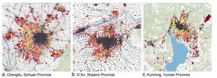
West meets East: Monitoring and modeling urbanization in China Land Cover-Land Use Change Program Science Team Meeting April 3, 2012
 West meets East: Monitoring and modeling urbanization in China Land Cover-Land Use Change Program Science Team Meeting April 3, 2012 Annemarie Schneider Center for Sustainability and the Global Environment,
Multiresolution Analysis of Urban Reflectance
 Multiresolution Analysis of Urban Reflectance Christopher Small Lamont Doherty Earth Observatory Columbia University Palisades, NY 10964 USA small@ldeo.columbia.edu Reprinted from: IEEE/ISPRS joint Workshop
USING HYPERSPECTRAL IMAGERY
 USING HYPERSPECTRAL IMAGERY AND LIDAR DATA TO DETECT PLANT INVASIONS 2016 ESRI CANADA SCHOLARSHIP APPLICATION CURTIS CHANCE M.SC. CANDIDATE FACULTY OF FORESTRY UNIVERSITY OF BRITISH COLUMBIA CURTIS.CHANCE@ALUMNI.UBC.CA
Aggregation of Sentinel-2 time series classifications as a solution for multitemporal analysis
 Aggregation of Sentinel-2 time series classifications as a solution for multitemporal analysis Stanisław Lewiński* a, Artur Nowakowski a, Radek Malinowski a, Marcin Rybicki a, Ewa Kukawska a, Michał Krupiński
Region Growing Tree Delineation In Urban Settlements
 2008 International Conference on Advanced Computer Theory and Engineering Region Growing Tree Delineation In Urban Settlements LAU BEE THENG, CHOO AI LING School of Computing and Design Swinburne University
Classification Techniques with Applications in Remote Sensing
 Classification Techniques with Applications in Remote Sensing Hunter Glanz California Polytechnic State University San Luis Obispo November 1, 2017 Glanz Land Cover Classification November 1, 2017 1 /
European Space Agency
 Guidelines - Guidelines how/when to interact during the WebEx session: - Due to the number of attendees, please keep always your webcam and microphone switched-off - You can use anytime the chat to all
Impacts of sensor noise on land cover classifications: sensitivity analysis using simulated noise
 Impacts of sensor noise on land cover classifications: sensitivity analysis using simulated noise Scott Mitchell 1 and Tarmo Remmel 2 1 Geomatics & Landscape Ecology Research Lab, Carleton University,
Spatial Decision Tree: A Novel Approach to Land-Cover Classification
 Spatial Decision Tree: A Novel Approach to Land-Cover Classification Zhe Jiang 1, Shashi Shekhar 1, Xun Zhou 1, Joseph Knight 2, Jennifer Corcoran 2 1 Department of Computer Science & Engineering 2 Department
A COMPARISON BETWEEN DIFFERENT PIXEL-BASED CLASSIFICATION METHODS OVER URBAN AREA USING VERY HIGH RESOLUTION DATA INTRODUCTION
 A COMPARISON BETWEEN DIFFERENT PIXEL-BASED CLASSIFICATION METHODS OVER URBAN AREA USING VERY HIGH RESOLUTION DATA Ebrahim Taherzadeh a, Helmi Z.M. Shafri a, Seyed Hassan Khalifeh Soltani b, Shattri Mansor
ISO Land Cover for Agricultural Regions of Canada, Circa 2000 Data Product Specification. Revision: A
 ISO 19131 Land Cover for Agricultural Regions of Canada, Circa 2000 Data Product Specification Revision: A Data specification: Land Cover for Agricultural Regions, circa 2000 Table of Contents 1. OVERVIEW...
GEO 874 Remote Sensing. Zihan Lin, Nafiseh Hagtalab, Ranjeet John
 GEO 874 Remote Sensing Zihan Lin, Nafiseh Hagtalab, Ranjeet John http://onlinelibrary.wiley.com/doi/10.1002/wat2.1147/full Landscape Heterogeneity S-I: homogeneous landscape using only cropland for the
Object-based land use/cover extraction from QuickBird image using Decision tree
 Object-based land use/cover extraction from QuickBird image using Decision tree Eltahir. M. Elhadi. 12, Nagi. Zomrawi 2 1-China University of Geosciences Faculty of Resources, Wuhan, 430074, China, 2-Sudan
Exploring the Use of Urban Greenspace through Cellular Network Activity
 Exploring the Use of Urban Greenspace through Cellular Network Activity Ramón Cáceres 1, James Rowland 1, Christopher Small 2, and Simon Urbanek 1 1 AT&T Labs Research, Florham Park, NJ, USA {ramon,jrr,urbanek}@research.att.com
Contents. Introduction Study area Data and Methodology Results Conclusions
 Modelling Spatial Changes in Suburban Areas of Istanbul Using Landsat 5 TM Data Şinasi Kaya(Assoc. Prof. Dr. ITU) Elif Sertel(Assoc. Prof. Dr. ITU) Dursun Z. Şeker(Prof. Dr. ITU) 1 Contents Introduction
DEVELOPMENT OF DIGITAL CARTOGRAPHIC DATABASE FOR MANAGING THE ENVIRONMENT AND NATURAL RESOURCES IN THE REPUBLIC OF SERBIA
 DEVELOPMENT OF DIGITAL CARTOGRAPHIC BASE FOR MANAGING THE ENVIRONMENT AND NATURAL RESOURCES IN THE REPUBLIC OF SERBIA Dragutin Protic, Ivan Nestorov Institute for Geodesy, Faculty of Civil Engineering,
Preparation of LULC map from GE images for GIS based Urban Hydrological Modeling
 International Conference on Modeling Tools for Sustainable Water Resources Management Department of Civil Engineering, Indian Institute of Technology Hyderabad: 28-29 December 2014 Abstract Preparation
USE OF SATELLITE IMAGES FOR AGRICULTURAL STATISTICS
 USE OF SATELLITE IMAGES FOR AGRICULTURAL STATISTICS National Administrative Department of Statistics DANE Colombia Geostatistical Department September 2014 Colombian land and maritime borders COLOMBIAN
Space Application in Support of Land Management for SDG Implementation
 Space Application in Support of Land Management for SDG Implementation Regional Expert Workshop on Land Accounting for SDG Monitoring and Reporting 26 September 2017 Space Application Section Information
Urban land cover and land use extraction from Very High Resolution remote sensing imagery
 Urban land cover and land use extraction from Very High Resolution remote sensing imagery Mengmeng Li* 1, Alfred Stein 1, Wietske Bijker 1, Kirsten M.de Beurs 2 1 Faculty of Geo-Information Science and
Land Cover Project ESA Climate Change Initiative. Processing chain for land cover maps dedicated to climate modellers.
 Land Cover Project ESA Climate Change Initiative Processing chain for land cover maps dedicated to climate modellers land_cover_cci S. Bontemps 1, P. Defourny 1, V. Kalogirou 2, F.M. Seifert 2 and O. Arino
Data Fusion and Multi-Resolution Data
 Data Fusion and Multi-Resolution Data Nature.com www.museevirtuel-virtualmuseum.ca www.srs.fs.usda.gov Meredith Gartner 3/7/14 Data fusion and multi-resolution data Dark and Bram MAUP and raster data Hilker
Urban Tree Canopy Assessment Purcellville, Virginia
 GLOBAL ECOSYSTEM CENTER www.systemecology.org Urban Tree Canopy Assessment Purcellville, Virginia Table of Contents 1. Project Background 2. Project Goal 3. Assessment Procedure 4. Economic Benefits 5.
Time Series Analysis with SAR & Optical Satellite Data
 Time Series Analysis with SAR & Optical Satellite Data Thomas Bahr ESRI European User Conference Thursday October 2015 harris.com Motivation Changes in land surface characteristics mirror a multitude of
Overview of Remote Sensing in Natural Resources Mapping
 Overview of Remote Sensing in Natural Resources Mapping What is remote sensing? Why remote sensing? Examples of remote sensing in natural resources mapping Class goals What is Remote Sensing A remote sensing
GIS and Remote Sensing
 Spring School Land use and the vulnerability of socio-ecosystems to climate change: remote sensing and modelling techniques GIS and Remote Sensing Katerina Tzavella Project Researcher PhD candidate Technology
C o p e r n i c u s L a n d M o n i t o r i n g S e r v i c e
 C o p e r n i c u s L a n d M o n i t o r i n g S e r v i c e Integration into existing Snow and Ice Services and draft product specifications Annett BARTSCH b.geos Copernicus High Resolution Snow and
Remote Sensing the Urban Landscape
 Remote Sensing the Urban Landscape Urban landscape are composed of a diverse assemblage of materials (concrete, asphalt, metal, plastic, shingles, glass, water, grass, shrubbery, trees, and soil) arranged
Suitability Mapping For Locating Special Economic Zone
 Suitability Mapping For Locating Special Economic Zone by Sudhir Gupta, Vinay Pandit, K.S.Rajan in Remote Sensing and Photogrammetry Society Conference, 5-7 September 2008, Falmouth, United Kingdom Report
Land cover research, applications and development needs in Slovakia
 Land cover research, applications and development needs in Slovakia Andrej Halabuk Institute of Landscape Ecology Slovak Academy of Sciences (ILE SAS) Štefánikova 3, 814 99 Bratislava, Slovakia Institute
Mapping Coastal Change Using LiDAR and Multispectral Imagery
 Mapping Coastal Change Using LiDAR and Multispectral Imagery Contributor: Patrick Collins, Technical Solutions Engineer Presented by TABLE OF CONTENTS Introduction... 1 Coastal Change... 1 Mapping Coastal
Developing a global, people-based definition of cities and settlements
 Developing a global, people-based definition of cities and settlements Cooperation between: Directorate General for Regional and, Joint Research Centre, EUROSTAT (European Commission, European Union) OECD,
Greening of Arctic: Knowledge and Uncertainties
 Greening of Arctic: Knowledge and Uncertainties Jiong Jia, Hesong Wang Chinese Academy of Science jiong@tea.ac.cn Howie Epstein Skip Walker Moscow, January 28, 2008 Global Warming and Its Impact IMPACTS
How the science of cities can help European policy makers: new analysis and perspectives
 How the science of cities can help European policy makers: new analysis and perspectives By Lewis Dijkstra, PhD Deputy Head of the Economic Analysis Unit, DG Regional and European Commission Overview Data
Advanced Image Analysis in Disaster Response
 Advanced Image Analysis in Disaster Response Creating Geographic Knowledge Thomas Harris ITT The information contained in this document pertains to software products and services that are subject to the
The Road to Data in Baltimore
 Creating a parcel level database from high resolution imagery By Austin Troy and Weiqi Zhou University of Vermont, Rubenstein School of Natural Resources State and local planning agencies are increasingly
DETECTION OF CHANGES IN FOREST LANDCOVER TYPE AFTER FIRES IN PORTUGAL
 DETECTION OF CHANGES IN FOREST LANDCOVER TYPE AFTER FIRES IN PORTUGAL Paulo M. Barbosa, Mário R. Caetano, and Teresa G. Santos Centro Nacional de Informação Geográfica (CNIG), Portugal barp@cnig.pt, mario@cnig.pt,
USE OF LANDSAT IMAGERY FOR EVALUATION OF LAND COVER / LAND USE CHANGES FOR A 30 YEAR PERIOD FOR THE LAKE ERIE WATERSHED
 USE OF LANDSAT IMAGERY FOR EVALUATION OF LAND COVER / LAND USE CHANGES FOR A 30 YEAR PERIOD FOR THE LAKE ERIE WATERSHED Mark E. Seidelmann Carolyn J. Merry Dept. of Civil and Environmental Engineering
Agricultural land-use from space. David Pairman and Heather North
 Agricultural land-use from space David Pairman and Heather North Talk Outline Motivation Challenges Different approach Paddock boundaries Classifications Examples Accuracy Issues Data sources Future possibilities
Deriving Uncertainty of Area Estimates from Satellite Imagery using Fuzzy Land-cover Classification
 International Journal of Information and Computation Technology. ISSN 0974-2239 Volume 3, Number 10 (2013), pp. 1059-1066 International Research Publications House http://www. irphouse.com /ijict.htm Deriving
New approach for land use mapping in the Netherlands (LGN6)
") New approach for land use mapping in the Netherlands (LGN6) Gerard Hazeu & Rini Schuiling Content Objectives Background LGN and its history National and European activities (e.g. INSPIRE) Methodology LGN6
New approach for land use mapping in the Netherlands (LGN6) Gerard Hazeu & Rini Schuiling Content Objectives Background LGN and its history National and European activities (e.g. INSPIRE) Methodology LGN6
This is trial version
 Journal of Rangeland Science, 2012, Vol. 2, No. 2 J. Barkhordari and T. Vardanian/ 459 Contents available at ISC and SID Journal homepage: www.rangeland.ir Full Paper Article: Using Post-Classification
VISUALIZATION URBAN SPATIAL GROWTH OF DESERT CITIES FROM SATELLITE IMAGERY: A PRELIMINARY STUDY
 CO-439 VISUALIZATION URBAN SPATIAL GROWTH OF DESERT CITIES FROM SATELLITE IMAGERY: A PRELIMINARY STUDY YANG X. Florida State University, TALLAHASSEE, FLORIDA, UNITED STATES ABSTRACT Desert cities, particularly
An Automated Object-Oriented Satellite Image Classification Method Integrating the FAO Land Cover Classification System (LCCS).
.") An Automated Object-Oriented Satellite Image Classification Method Integrating the FAO Land Cover Classification System (LCCS). Ruvimbo Gamanya Sibanda Prof. Dr. Philippe De Maeyer Prof. Dr. Morgan De
An Automated Object-Oriented Satellite Image Classification Method Integrating the FAO Land Cover Classification System (LCCS). Ruvimbo Gamanya Sibanda Prof. Dr. Philippe De Maeyer Prof. Dr. Morgan De
Remote Sensing and Gridded Population Data: Considerations for the Population-Environment Research Community
 Remote Sensing and Gridded Population Data: Considerations for the Population-Environment Research Community Panel contribution to the Population-Environment Research Network Cyberseminar, People and Pixels
Change Detection Methods Using Band Ratio and Raster to Vector Transform
 Change Detection Methods Using Band Ratio and Raster to Vector Transform Gheidaa Sabeeh Al-Hassany Remote sensing Unit, College of Science, University of Baghdad, Baghdad, Iraq Gheida2009@yahoo.com Abstract
GIS-AIDED PER-SEGMENT SCENE ANALYSIS OF MULTI-TEMPORAL SPACEBORNE SAR SERIES WITH APPLICATION TO URBAN AREAS
 61 GIS-AIDED PER-SEGMENT SCENE ANALYSIS OF MULTI-TEMPORAL SPACEBORNE SAR SERIES WITH APPLICATION TO URBAN AREAS G. Trianni 1, F. Dell'Acqua 2 and P. Gamba 2 1 SERCO c/o ESA/ESRIN, EO Science and Applications
Measuring and Monitoring SDGs in Portugal: Ratio of land consumption rate to population growth rate Mountain Green Cover Index
 Measuring and Monitoring SDGs in Portugal: 11.3.1Ratio of land consumption rate to population growth rate 15.4.2 Mountain Green Cover Index United Nations World Geospatial Information Congress João David
Global City Definition
 Regional Training Workshop on Human Settlement Indicators Global City Definition Dennis Mwaniki Global Urban Observatory, Research and Capacity Development Branch, UN-Habitat Bangkok, Thailand Outline
Applications of GIS and Remote Sensing for Analysis of Urban Heat Island
 Chuanxin Zhu Professor Peter V. August Professor Yeqiao Wang NRS 509 December 15, 2016 Applications of GIS and Remote Sensing for Analysis of Urban Heat Island Since the last century, the global mean surface
Digitization in a Census
 Topics Connectivity of Geographic Data Sketch Maps Data Organization and Geodatabases Managing a Digitization Project Quality and Control Topology Metadata 1 Topics (continued) Interactive Selection Snapping
Using MERIS and MODIS for Land Cover Mapping in the Netherlands
 Using MERIS and for Land Cover Mapping in the Netherlands Raul Zurita Milla, Michael Schaepman and Jan Clevers Wageningen University, Centre for Geo-Information, NL Introduction Actual and reliable information
Monitoring of Tropical Deforestation and Land Cover Changes in Protected Areas: JRC Perspective
 Monitoring of Tropical Deforestation and Land Cover Changes in Protected Areas: JRC Perspective Z. Szantoi, A. Brink, P. Mayaux, F. Achard Monitoring Of Natural resources for DEvelopment (MONDE) Joint
Use of Corona, Landsat TM, Spot 5 images to assess 40 years of land use/cover changes in Cavusbasi
 New Strategies for European Remote Sensing, Olui (ed.) 2005 Millpress, Rotterdam, ISBN 90 5966 003 X Use of Corona, Landsat TM, Spot 5 images to assess 40 years of land use/cover changes in Cavusbasi N.
GLOBAL/CONTINENTAL LAND COVER MAPPING AND MONITORING
 GLOBAL/CONTINENTAL LAND COVER MAPPING AND MONITORING Ryutaro Tateishi, Cheng Gang Wen, and Jong-Geol Park Center for Environmental Remote Sensing (CEReS), Chiba University 1-33 Yayoi-cho Inage-ku Chiba
Object Based Land Cover Extraction Using Open Source Software
 Object Based Land Cover Extraction Using Open Source Software Abhasha Joshi 1, Janak Raj Joshi 2, Nawaraj Shrestha 3, Saroj Sreshtha 4, Sudarshan Gautam 5 1 Instructor, Land Management Training Center,
Overview on Land Cover and Land Use Monitoring in Russia
 Russian Academy of Sciences Space Research Institute Overview on Land Cover and Land Use Monitoring in Russia Sergey Bartalev Joint NASA LCLUC Science Team Meeting and GOFC-GOLD/NERIN, NEESPI Workshop
Effective Utilization of Synthetic Aperture Radar (SAR) Imagery in Rapid Damage Assessment
 Imagery in Rapid Damage Assessment") Effective Utilization of Synthetic Aperture Radar (SAR) Imagery in Rapid Damage Assessment Case Study Pakistan Floods SUPARCO M. Maisam Raza, Ahmad H. Rabbani SEQUENCE Flood Monitoring using Satellite
Effective Utilization of Synthetic Aperture Radar (SAR) Imagery in Rapid Damage Assessment Case Study Pakistan Floods SUPARCO M. Maisam Raza, Ahmad H. Rabbani SEQUENCE Flood Monitoring using Satellite
Vegetation Change Detection of Central part of Nepal using Landsat TM
 Vegetation Change Detection of Central part of Nepal using Landsat TM Kalpana G. Bastakoti Department of Geography, University of Calgary, kalpanagb@gmail.com Abstract This paper presents a study of detecting
Defining microclimates on Long Island using interannual surface temperature records from satellite imagery
 Defining microclimates on Long Island using interannual surface temperature records from satellite imagery Deanne Rogers*, Katherine Schwarting, and Gilbert Hanson Dept. of Geosciences, Stony Brook University,
Proceedings of the 13 th International Conference on Environmental Science and Technology Athens, Greece, 5-7 September 2013
 Proceedings of the 13 th International Conference on Environmental Science and Technology Athens, Greece, 5-7 September 2013 OBSERVATION OF THE CHANGES AND THE DEGRADATION OF THE FORESTS AFTER THE FIRE
ANALYSING THE DIVERSITY OF DEPRIVED AREAS IN MUMBAI, INDIA
 ANALYSING THE DIVERSITY OF DEPRIVED AREAS IN MUMBAI, INDIA MONIKA KUFFER (M.KUFFER@UTWENTE.NL) KARIN PFEFFER, RICHARD SLIUZAS, ISA BAUD, MARTIN VAN MAARSEVEEN Source: Google Earth CONTENT OF PRESENTATION
Lech GAWUC, Joanna STRUZEWSKA. Meteorology Division Faculty of Environmental Engineering Warsaw University of Technology Warsaw, Poland
 Analysis of the impact of different temporal aggregation techniques of land surface temperature on SUHI indicators and the relationship of surface temperature with population density and night lighting
Comparison between Land Surface Temperature Retrieval Using Classification Based Emissivity and NDVI Based Emissivity
 Comparison between Land Surface Temperature Retrieval Using Classification Based Emissivity and NDVI Based Emissivity Isabel C. Perez Hoyos NOAA Crest, City College of New York, CUNY, 160 Convent Avenue,
Methodological issues in the development of accessibility measures to services: challenges and possible solutions in the Canadian context
 Methodological issues in the development of accessibility measures to services: challenges and possible solutions in the Canadian context Alessandro Alasia 1, Frédéric Bédard 2, and Julie Bélanger 1 (1)
LAND SURFACE TEMPERATURE CHANGE AFTER CONSTRUCTION OF THE KOZJAK DAM BASED ON REMOTE SENSING DATA
 LAND SURFACE TEMPERATURE CHANGE AFTER CONSTRUCTION OF THE KOZJAK DAM BASED ON REMOTE SENSING DATA DOI: http://dx.doi.org/10.18509/gbp.2016.02 UDC: 627.82:551.525.2]:528.85(497.782) MSc. Gordana JOVANOVSKA