Spatial Decision Tree: A Novel Approach to Land-Cover Classification
|
|
|
- Damian Nicholson
- 5 years ago
- Views:
Transcription


1 Spatial Decision Tree: A Novel Approach to Land-Cover Classification Zhe Jiang 1, Shashi Shekhar 1, Xun Zhou 1, Joseph Knight 2, Jennifer Corcoran 2 1 Department of Computer Science & Engineering 2 Department of Forest Resources University of Minnesota, Twin Cities 1
2 Highlights Public engagement with science and technology : Coursera MOOC, From GPS and Google Maps to Spatial Computing, reached 21,844 participants across 182 countries Enhanced infrastructure for education Interdisciplinary survey paper on spatiotemporal change footprint discovery Encyclopedia of GIS (Springer, 2 nd Edition): Multiple articles on climate change APA/IEEE Computing in Sc. & Eng. special issue on Computing and Climate Enhanced infrastructure for research Spatial decision trees can help improve wetland maps for climate models
3 Highlights Understanding Large semantic gap between Data Science and Climate Science Data Science results are hard to interpret in Climate Science Data Science assumptions violate laws of physics Concepts: unnecessary errors, e.g., salt and pepper noise Physics-Guided Data Mining concepts are potentially transformative Ex. Spatial Decision Trees: explicit physics (e.g., continuity) to wetland mapping Ex. Intervals of Persistent Change detection uses Physics (e.g., violation of continuity)


4 Spatial Decision Tree: Motivation Wetland mapping: Climate Change: wetlands major source of methane 1 manage natural disasters, defense against hurricanes, buffer of floods. maintain biodiversity, habitats to wildlife species Greenhouse Gas Methane flood control wildlife habitats 5 1 Bryan Walsh, How Wetlands Worsen Climate Change, Time, Magazine, 2010
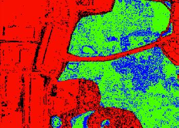
5 Wetland Mapping Example Input: Output: train test (a) aerial photo (b) aerial photo (c) true classes (d) DT prediction wetland dry land Training samples: upper half Test samples: lower half Spatial neighborhood: DT: decision tree 6
 Spatial anisotropy asymmetric spatial neighborhood (blue circle)")

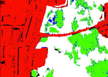
6 Challenges Spatial autocorrelation effect samples violate i.i.d. assumption salt-and-pepper noise (white circles) Spatial anisotropy asymmetric spatial neighborhood (blue circle) Spatial heterogeneity areas with the same features correspond to distinct class labels (white circle) High computational cost large amount of focal computation with different spatial neighborhoods sizes Ground truth classes Decision tree prediction feature maps ground truth wetland dry land 7
7 Given: Problem Statement training & test samples from a raster spatial framework spatial neighborhood, its maximum size Find: a (spatial) decision tree Objective: minimize classification error and salt-and-pepper noise Constraint: training samples are contiguous patches spatial autocorrelation, anisotropy, and heterogeneity exist training dataset can be large with high computational cost 8
8 Input: Example with Decision Tree Output: 9 ID f 1 f 2 class A 3 3 red B 3 3 red C 1 2 green D 3 1 red E 3 1 red F 3 1 red G 3 3 red H 1 2 green I 1 2 green J 3 1 red K 1 1 red L 3 1 red M 1 2 green N 1 2 green O 3 1 red P 3 1 red Q 3 1 red R 1 1 red pixel id A B C D E F G H I J K L M N O P Q R In this example, Gamma index Γ 1 on feature f 1 is unique. Most often, Γ 1 is computed on the fly. decision tree f 1 1 yes no green red C H I M N K R A B D E F G J L O P Q R predicted map A B C D E F G H I J K L M N O P Q R salt-and-pepper noise pixel K from decision tree
9 Related Work Summary single decision tree traditional decision tree spatial decision tree Tree Existing Work local feature test & information gain: Proposed Work focal feature test & spatial information gain: Ensemble bootstrap sampling: geographic space partitioning: random forest ensemble spatial ensemble ensemble of decision trees 10
10 Proposed Approach Focal Test Local Focal feature test Test both local and focal (neighborhood) information focal test uses local autocorrelation statistics, e.g., Gamma index Focal Zonal 11

11 Proposed Approach - 2 tree traversal direction depends on both local and focal (neighborhood) information focal test uses local autocorrelation statistics, e.g., Gamma index (Γ) neighborhood where: i, j: pixel locations S i,j : similarity between location i and j W i,j is adjacency matrix element 12
12 Example Focal Tests traditional decision tree spatial decision tree inputs: table of records ID f 1 f 2 Γ 1 class C A green red H B green red C I green D K red M E green red N F green red G R red H A green red B I green red D J red K E red F L red M G green red N J green red O L red O P red Q P red Q R red 13 f 1 1 yes no green red C H I M N K R pixel id A B D E F G predicted map A B C D E F G H I J K L M N O P Q R A B C D E F G H I J K L M N O P Q R J L O P Q inputs: feature maps, class map feature f feature f class map adaptive neigh., 3 by 3 focal function Γ ( f 1 1 ) * (Γ 1 0) + - green red C H I M N predicted map A B D E F G A B C D E F G H I J K L M N O P Q R J K L O P Q R
 2 classes: wetland, dry land features: high")

13 Questions to answer: Evaluation: Case Study SDT v.s. DT - classification accuracy SDT v.s. DT - salt-and-pepper noise Computational scalability of SDT Dataset: Chanhassen, MN (wetland mapping) 2 classes: wetland, dry land features: high resolution (3m*3m) aerial photos (RGB, NIR, NDVI) in 2003, 2005, 2008 Training set: randomly select circular patches; Test set: remaining pixels on the scene; Three scenes are used. Max neighborhood size: 11 pixels by 11 pixels Chanhassen, MN 14
")
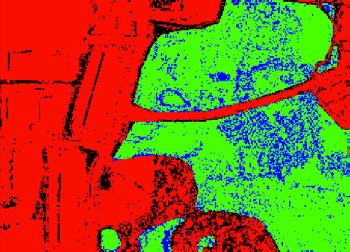
14 Wetland Mapping Comparison Scene 1 Input: Output: train test (a) aerial photo (b) aerial photo (c) true classes (d) DT prediction wetland dry land (e) SDT prediction Training samples: upper half Test samples: lower half Spatial neighborhood: DT: decision tree SDT: spatial decision tree (11x11 neighborhood) 15
 Trends: 1.")

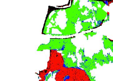
15 Classification Performance Scene 2 decision tree (DT) spatial decision tree (SDT) Trends: 1.DT: salt-and-pepper noise 2.SDT improve accuracy, salt-and-pepper noise levels true wetland true dryland false wetland false dryland
16 Evaluation: Classification Performance Classification accuracy and salt-and-pepper noise level Model Confusion Matrix Prec. Recall F measure Autocorrelation DT 99,141 10, ,346 45,805 SDT 99,390 10, ,618 50,533 Significance test between confusion matrices: Model Khat Khat Variance Z-score significance DT *10-6 SDT * significant Spatial decision tree reduces salt-and-pepper noise and misclassification errors, compared with decision trees. 17

17 Computational Bottleneck Analysis Analysis: 1. focal computation takes the vast majority of the time 2. focal computation cost increases faster with the training set size Focal computation is the bottleneck! 18
18 19 Incremental Update Approach Key idea: reduce redundant focal computation by reusing results across candidate test thresholds Γ(f < δ) (a) feature values (b) indicators, focal values for δ=1 (c) indicators, focal values for δ=2 candidate δ {1, 2, 3, 4, 5, 6, 7, 8} (d) indicators, focal values for δ=3 (e) indicators, focal values for δ=4

19 Evaluation of Computational Cost Notation of symbols F # of features (12) N # of samples N d S max N 0 # of distinct feature values max neigh size min node size The refined algorithm significantly reduces computational cost. 20
20 Conclusions Ignoring auto-correlation leads to errors, e.g., salt-n-pepper noise Proposed a novel spatial decision tree approach with focal tests Evaluation shows that proposed method reduced salt-n-pepper noise And improved classification accuracy Designed computational refinements to improve scalability 21
21 Publications on Spatial Decision Trees [1] Z. Jiang, S. Shekhar, X. Zhou, J. Knight, J. Corcoran: Focal-Test-Based Spatial Decision Tree Learning. IEEE Transactions on Knowledge and Data Engineering (TKDE) 27(6): (2015) [2] Z. Jiang, S. Shekhar, X. Zhou, J. Knight, J. Corcoran: Focal-Test-Based Spatial Decision Tree Learning: A Summary of Results. IEEE International Conference on Data Mining (ICDM) 2013: [3] Z. Jiang, S. Shekhar, P. Mohan, J. Knight, and J. Corcoran. "Learning spatial decision tree for geographical classification: a summary of results. International Conference on Advances in GIS, pp ACM, [4] Z. Jiang, S. Shekhar, A. Kamzin, and J. Knight. "Learning a Spatial Ensemble of Classifiers for Raster Classification: A Summary of Results. IEEE International Conference on Data Mining Workshop, IEEE,
22 Challenges Revisited Spatial autocorrelation effect samples violate i.i.d. assumption salt-and-pepper noise (white circles) Spatial anisotropy asymmetric spatial neighborhood (blue circle) Spatial heterogeneity areas with the same features correspond to distinct class labels (white circle) High computational cost large amount of focal computation with different spatial neighborhoods sizes Ground truth classes Decision tree prediction feature maps ground truth wetland dry land 23
23 Future Work Key idea I: focal feature test tree traversal direction depends on both local and focal (neighborhood) information focal test uses local autocorrelation statistics, e.g., Gamma index Key idea II: spatial information gain (SIG) SIG = Info. Gain * α + Spatial Autocorrelation * (1 α) tree node test selection depends on both class purification and autocorrelation structure Key idea III: spatial ensemble of local trees geographic space partitioning, learn local classifiers 24
24 Proposed Approach: Spatial Ensemble yes red traditional ensemble (random forest) 1. assume i.i.d. distribution 2. bootstrap sampling 3. learn a tree from one sampling with random feature subsets yes f 1 1 red no green f 1 1 no green yes red f 1 1 no green yes red spatial ensemble (spatial forest) 1. assume spatial heterogeneity 2. spatial partitioning 3. learn local tree model in each partition yes f 1 1 red no green f 1 1 no green yes red f 1 1 no green 25


")

25 one feature image ground truth spatial cluster (islands) archipelagos partition P1 partition P2 prediction in P1 prediction in P2 ground truth single DT prediction spatial ensemble random forest 26
Models to carry out inference vs. Models to mimic (spatio-temporal) systems 5/5/15
 systems 5/5/15") Models to carry out inference vs. Models to mimic (spatio-temporal) systems 5/5/15 Ring-Shaped Hotspot Detection: A Summary of Results, IEEE ICDM 2014 (w/ E. Eftelioglu et al.) Where is a crime source?
Models to carry out inference vs. Models to mimic (spatio-temporal) systems 5/5/15 Ring-Shaped Hotspot Detection: A Summary of Results, IEEE ICDM 2014 (w/ E. Eftelioglu et al.) Where is a crime source?
Introduction to Spatial Big Data Analytics. Zhe Jiang Office: SEC 3435
 Introduction to Spatial Big Data Analytics Zhe Jiang zjiang@cs.ua.edu Office: SEC 3435 1 What is Big Data? Examples Internet data (images from the web) Earth observation data (nasa.gov) wikimedia.org www.me.mtu.edu
Data Mining: Concepts and Techniques. (3 rd ed.) Chapter 8. Chapter 8. Classification: Basic Concepts
 Chapter 8. Chapter 8. Classification: Basic Concepts") Data Mining: Concepts and Techniques (3 rd ed.) Chapter 8 1 Chapter 8. Classification: Basic Concepts Classification: Basic Concepts Decision Tree Induction Bayes Classification Methods Rule-Based Classification
Data Mining: Concepts and Techniques (3 rd ed.) Chapter 8 1 Chapter 8. Classification: Basic Concepts Classification: Basic Concepts Decision Tree Induction Bayes Classification Methods Rule-Based Classification
UPDATING THE MINNESOTA NATIONAL WETLAND INVENTORY
 UPDATING THE MINNESOTA NATIONAL WETLAND INVENTORY An Integrated Approach Using Object-Oriented Image Analysis, Human Air-Photo Interpretation and Machine Learning AARON SMITH EQUINOX ANALYTICS INC. FUNDING
Land cover/land use mapping and cha Mongolian plateau using remote sens. Title. Author(s) Bagan, Hasi; Yamagata, Yoshiki. Citation Japan.
 Bagan, Hasi; Yamagata, Yoshiki. Citation Japan.") Title Land cover/land use mapping and cha Mongolian plateau using remote sens Author(s) Bagan, Hasi; Yamagata, Yoshiki International Symposium on "The Imp Citation Region Specific Systems". 6 Nove Japan.
Title Land cover/land use mapping and cha Mongolian plateau using remote sens Author(s) Bagan, Hasi; Yamagata, Yoshiki International Symposium on "The Imp Citation Region Specific Systems". 6 Nove Japan.
Neural Networks and Ensemble Methods for Classification
 Neural Networks and Ensemble Methods for Classification NEURAL NETWORKS 2 Neural Networks A neural network is a set of connected input/output units (neurons) where each connection has a weight associated
SUPERVISED LEARNING: INTRODUCTION TO CLASSIFICATION
 SUPERVISED LEARNING: INTRODUCTION TO CLASSIFICATION 1 Outline Basic terminology Features Training and validation Model selection Error and loss measures Statistical comparison Evaluation measures 2 Terminology
DETECTING HUMAN ACTIVITIES IN THE ARCTIC OCEAN BY CONSTRUCTING AND ANALYZING SUPER-RESOLUTION IMAGES FROM MODIS DATA INTRODUCTION
 DETECTING HUMAN ACTIVITIES IN THE ARCTIC OCEAN BY CONSTRUCTING AND ANALYZING SUPER-RESOLUTION IMAGES FROM MODIS DATA Shizhi Chen and YingLi Tian Department of Electrical Engineering The City College of
Spatial Data Science. Soumya K Ghosh
 Workshop on Data Science and Machine Learning (DSML 17) ISI Kolkata, March 28-31, 2017 Spatial Data Science Soumya K Ghosh Professor Department of Computer Science and Engineering Indian Institute of Technology,
IV Course Spring 14. Graduate Course. May 4th, Big Spatiotemporal Data Analytics & Visualization
 Spatiotemporal Data Visualization IV Course Spring 14 Graduate Course of UCAS May 4th, 2014 Outline What is spatiotemporal data? How to analyze spatiotemporal data? How to visualize spatiotemporal data?
Data Mining Classification: Basic Concepts and Techniques. Lecture Notes for Chapter 3. Introduction to Data Mining, 2nd Edition
 Data Mining Classification: Basic Concepts and Techniques Lecture Notes for Chapter 3 by Tan, Steinbach, Karpatne, Kumar 1 Classification: Definition Given a collection of records (training set ) Each
CS145: INTRODUCTION TO DATA MINING
 CS145: INTRODUCTION TO DATA MINING 4: Vector Data: Decision Tree Instructor: Yizhou Sun yzsun@cs.ucla.edu October 10, 2017 Methods to Learn Vector Data Set Data Sequence Data Text Data Classification Clustering
Urban remote sensing: from local to global and back
 Urban remote sensing: from local to global and back Paolo Gamba University of Pavia, Italy A few words about Pavia Historical University (1361) in a nice town slide 3 Geoscience and Remote Sensing Society
Midterm, Fall 2003
 5-78 Midterm, Fall 2003 YOUR ANDREW USERID IN CAPITAL LETTERS: YOUR NAME: There are 9 questions. The ninth may be more time-consuming and is worth only three points, so do not attempt 9 unless you are
Semantic Geospatial Data Integration and Mining for National Security
 Semantic Geospatial Data Integration and Mining for National Security Latifur Khan Ashraful Alam Ganesh Subbiah Bhavani Thuraisingham University of Texas at Dallas (Funded by Raytheon Corporation) Shashi
Anomaly Detection for the CERN Large Hadron Collider injection magnets
 Anomaly Detection for the CERN Large Hadron Collider injection magnets Armin Halilovic KU Leuven - Department of Computer Science In cooperation with CERN 2018-07-27 0 Outline 1 Context 2 Data 3 Preprocessing
Machine learning comes from Bayesian decision theory in statistics. There we want to minimize the expected value of the loss function.
 Bayesian learning: Machine learning comes from Bayesian decision theory in statistics. There we want to minimize the expected value of the loss function. Let y be the true label and y be the predicted
When Dictionary Learning Meets Classification
 When Dictionary Learning Meets Classification Bufford, Teresa 1 Chen, Yuxin 2 Horning, Mitchell 3 Shee, Liberty 1 Mentor: Professor Yohann Tendero 1 UCLA 2 Dalhousie University 3 Harvey Mudd College August
Performance Evaluation and Comparison
 Outline Hong Chang Institute of Computing Technology, Chinese Academy of Sciences Machine Learning Methods (Fall 2012) Outline Outline I 1 Introduction 2 Cross Validation and Resampling 3 Interval Estimation
New Regional Co-location Pattern Mining Method Using Fuzzy Definition of Neighborhood
 New Regional Co-location Pattern Mining Method Using Fuzzy Definition of Neighborhood Mohammad Akbari 1, Farhad Samadzadegan 2 1 PhD Candidate of Dept. of Surveying & Geomatics Eng., University of Tehran,
Learning theory. Ensemble methods. Boosting. Boosting: history
 Learning theory Probability distribution P over X {0, 1}; let (X, Y ) P. We get S := {(x i, y i )} n i=1, an iid sample from P. Ensemble methods Goal: Fix ɛ, δ (0, 1). With probability at least 1 δ (over
Statistical Perspectives on Geographic Information Science. Michael F. Goodchild University of California Santa Barbara
 Statistical Perspectives on Geographic Information Science Michael F. Goodchild University of California Santa Barbara Statistical geometry Geometric phenomena subject to chance spatial phenomena emphasis
Statistical Machine Learning from Data
 Samy Bengio Statistical Machine Learning from Data 1 Statistical Machine Learning from Data Ensembles Samy Bengio IDIAP Research Institute, Martigny, Switzerland, and Ecole Polytechnique Fédérale de Lausanne
GeoComputation 2011 Session 4: Posters Discovering Different Regimes of Biodiversity Support Using Decision Tree Learning T. F. Stepinski 1, D. White
 Discovering Different Regimes of Biodiversity Support Using Decision Tree Learning T. F. Stepinski 1, D. White 2, J. Salazar 3 1 Department of Geography, University of Cincinnati, Cincinnati, OH 45221-0131,
Review of Lecture 1. Across records. Within records. Classification, Clustering, Outlier detection. Associations
 Review of Lecture 1 This course is about finding novel actionable patterns in data. We can divide data mining algorithms (and the patterns they find) into five groups Across records Classification, Clustering,
Construction and Analysis of Climate Networks
 Construction and Analysis of Climate Networks Karsten Steinhaeuser University of Minnesota Workshop on Understanding Climate Change from Data Minneapolis, MN August 15, 2011 Working Definitions Knowledge
The Solution to Assignment 6
 The Solution to Assignment 6 Problem 1: Use the 2-fold cross-validation to evaluate the Decision Tree Model for trees up to 2 levels deep (that is, the maximum path length from the root to the leaves is
Unsupervised Anomaly Detection for High Dimensional Data
 Unsupervised Anomaly Detection for High Dimensional Data Department of Mathematics, Rowan University. July 19th, 2013 International Workshop in Sequential Methodologies (IWSM-2013) Outline of Talk Motivation
SPATIAL DATA MINING. Ms. S. Malathi, Lecturer in Computer Applications, KGiSL - IIM
 SPATIAL DATA MINING Ms. S. Malathi, Lecturer in Computer Applications, KGiSL - IIM INTRODUCTION The main difference between data mining in relational DBS and in spatial DBS is that attributes of the neighbors
Data Mining und Maschinelles Lernen
 Data Mining und Maschinelles Lernen Ensemble Methods Bias-Variance Trade-off Basic Idea of Ensembles Bagging Basic Algorithm Bagging with Costs Randomization Random Forests Boosting Stacking Error-Correcting
Chapter 6. Fundamentals of GIS-Based Data Analysis for Decision Support. Table 6.1. Spatial Data Transformations by Geospatial Data Types
 Chapter 6 Fundamentals of GIS-Based Data Analysis for Decision Support FROM: Points Lines Polygons Fields Table 6.1. Spatial Data Transformations by Geospatial Data Types TO: Points Lines Polygons Fields
Data Fusion and Multi-Resolution Data
 Data Fusion and Multi-Resolution Data Nature.com www.museevirtuel-virtualmuseum.ca www.srs.fs.usda.gov Meredith Gartner 3/7/14 Data fusion and multi-resolution data Dark and Bram MAUP and raster data Hilker
FINAL: CS 6375 (Machine Learning) Fall 2014
 Fall 2014") FINAL: CS 6375 (Machine Learning) Fall 2014 The exam is closed book. You are allowed a one-page cheat sheet. Answer the questions in the spaces provided on the question sheets. If you run out of room for
FINAL: CS 6375 (Machine Learning) Fall 2014 The exam is closed book. You are allowed a one-page cheat sheet. Answer the questions in the spaces provided on the question sheets. If you run out of room for
AGOG 485/585 /APLN 533 Spring Lecture 5: MODIS land cover product (MCD12Q1). Additional sources of MODIS data
. Additional sources of MODIS data") AGOG 485/585 /APLN 533 Spring 2019 Lecture 5: MODIS land cover product (MCD12Q1). Additional sources of MODIS data Outline Current status of land cover products Overview of the MCD12Q1 algorithm Mapping
AGOG 485/585 /APLN 533 Spring 2019 Lecture 5: MODIS land cover product (MCD12Q1). Additional sources of MODIS data Outline Current status of land cover products Overview of the MCD12Q1 algorithm Mapping
Universität Potsdam Institut für Informatik Lehrstuhl Maschinelles Lernen. Decision Trees. Tobias Scheffer
 Universität Potsdam Institut für Informatik Lehrstuhl Maschinelles Lernen Decision Trees Tobias Scheffer Decision Trees One of many applications: credit risk Employed longer than 3 months Positive credit
Data Mining Classification: Basic Concepts, Decision Trees, and Model Evaluation
 Data Mining Classification: Basic Concepts, Decision Trees, and Model Evaluation Lecture Notes for Chapter 4 Part I Introduction to Data Mining by Tan, Steinbach, Kumar Adapted by Qiang Yang (2010) Tan,Steinbach,
KNOWLEDGE-BASED CLASSIFICATION OF LAND COVER FOR THE QUALITY ASSESSEMENT OF GIS DATABASE. Israel -
 KNOWLEDGE-BASED CLASSIFICATION OF LAND COVER FOR THE QUALITY ASSESSEMENT OF GIS DATABASE Ammatzia Peled a,*, Michael Gilichinsky b a University of Haifa, Department of Geography and Environmental Studies,
INTRODUCTION TO GEOGRAPHIC INFORMATION SYSTEM By Reshma H. Patil
 INTRODUCTION TO GEOGRAPHIC INFORMATION SYSTEM By Reshma H. Patil ABSTRACT:- The geographical information system (GIS) is Computer system for capturing, storing, querying analyzing, and displaying geospatial
Predictive Analytics on Accident Data Using Rule Based and Discriminative Classifiers
 Advances in Computational Sciences and Technology ISSN 0973-6107 Volume 10, Number 3 (2017) pp. 461-469 Research India Publications http://www.ripublication.com Predictive Analytics on Accident Data Using
43400 Serdang Selangor, Malaysia Serdang Selangor, Malaysia 4
 An Extended ID3 Decision Tree Algorithm for Spatial Data Imas Sukaesih Sitanggang # 1, Razali Yaakob #2, Norwati Mustapha #3, Ahmad Ainuddin B Nuruddin *4 # Faculty of Computer Science and Information
On Improving the k-means Algorithm to Classify Unclassified Patterns
 On Improving the k-means Algorithm to Classify Unclassified Patterns Mohamed M. Rizk 1, Safar Mohamed Safar Alghamdi 2 1 Mathematics & Statistics Department, Faculty of Science, Taif University, Taif,
Ensemble Methods. NLP ML Web! Fall 2013! Andrew Rosenberg! TA/Grader: David Guy Brizan
 Ensemble Methods NLP ML Web! Fall 2013! Andrew Rosenberg! TA/Grader: David Guy Brizan How do you make a decision? What do you want for lunch today?! What did you have last night?! What are your favorite
An Empirical Study of Building Compact Ensembles
 An Empirical Study of Building Compact Ensembles Huan Liu, Amit Mandvikar, and Jigar Mody Computer Science & Engineering Arizona State University Tempe, AZ 85281 {huan.liu,amitm,jigar.mody}@asu.edu Abstract.
Stephen Scott.
 1 / 35 (Adapted from Ethem Alpaydin and Tom Mitchell) sscott@cse.unl.edu In Homework 1, you are (supposedly) 1 Choosing a data set 2 Extracting a test set of size > 30 3 Building a tree on the training
Computer Vision Group Prof. Daniel Cremers. 10a. Markov Chain Monte Carlo
 Group Prof. Daniel Cremers 10a. Markov Chain Monte Carlo Markov Chain Monte Carlo In high-dimensional spaces, rejection sampling and importance sampling are very inefficient An alternative is Markov Chain
Variance Reduction and Ensemble Methods
 Variance Reduction and Ensemble Methods Nicholas Ruozzi University of Texas at Dallas Based on the slides of Vibhav Gogate and David Sontag Last Time PAC learning Bias/variance tradeoff small hypothesis
Combination of Microwave and Optical Remote Sensing in Land Cover Mapping
 Combination of Microwave and Optical Remote Sensing in Land Cover Mapping Key words: microwave and optical remote sensing; land cover; mapping. SUMMARY Land cover map mapping of various types use conventional
Unsupervised Image Segmentation Using Comparative Reasoning and Random Walks
 Unsupervised Image Segmentation Using Comparative Reasoning and Random Walks Anuva Kulkarni Carnegie Mellon University Filipe Condessa Carnegie Mellon, IST-University of Lisbon Jelena Kovacevic Carnegie
Deriving Uncertainty of Area Estimates from Satellite Imagery using Fuzzy Land-cover Classification
 International Journal of Information and Computation Technology. ISSN 0974-2239 Volume 3, Number 10 (2013), pp. 1059-1066 International Research Publications House http://www. irphouse.com /ijict.htm Deriving
Advanced Statistical Methods: Beyond Linear Regression
 Advanced Statistical Methods: Beyond Linear Regression John R. Stevens Utah State University Notes 3. Statistical Methods II Mathematics Educators Worshop 28 March 2009 1 http://www.stat.usu.edu/~jrstevens/pcmi
1 Handling of Continuous Attributes in C4.5. Algorithm
 .. Spring 2009 CSC 466: Knowledge Discovery from Data Alexander Dekhtyar.. Data Mining: Classification/Supervised Learning Potpourri Contents 1. C4.5. and continuous attributes: incorporating continuous
Applying Machine Learning for Gravitational-wave Burst Data Analysis
 Applying Machine Learning for Gravitational-wave Burst Data Analysis Junwei Cao LIGO Scientific Collaboration Research Group Research Institute of Information Technology Tsinghua University June 29, 2016
ASIA GEOSPATIAL FORUM 2011 Eco-Friendly Walk Score Calculator Choosing a Place to Live with GIS
 ASIA GEOSPATIAL FORUM 2011 Eco-Friendly Walk Score Calculator Choosing a Place to Live with GIS Ko Ko Lwin and Yuji Murayama Division of Spatial Information Science Graduate School of Life and Environmental
MIDTERM: CS 6375 INSTRUCTOR: VIBHAV GOGATE October,
 MIDTERM: CS 6375 INSTRUCTOR: VIBHAV GOGATE October, 23 2013 The exam is closed book. You are allowed a one-page cheat sheet. Answer the questions in the spaces provided on the question sheets. If you run
Transportation Data Mining: Vision & Challenges
 Transportation Data Mining: Vision & Challenges Shashi Shekhar McKnight Distinguished University Professor University of Minnesota www.cs.umn.edu/~shekhar Pervasive Data for Transportation: Innovations
Urban land use information retrieval based on scene classification of Google Street View images
 Urban land use information retrieval based on scene classification of Google Street View images Xiaojiang Li 1, Chuanrong Zhang 1 1 Department of Geography, University of Connecticut, Storrs Email: {xiaojiang.li;chuanrong.zhang}@uconn.edu
Development of statewide 30 meter winter sage grouse habitat models for Utah
 Development of statewide 30 meter winter sage grouse habitat models for Utah Ben Crabb, Remote Sensing and Geographic Information System Laboratory, Department of Wildland Resources, Utah State University
Land Cover Classification Mapping & its uses for Planning
 Land Cover Classification Mapping & its uses for Planning What is Land Cover Classification Mapping? Examples of an actual product Why use Land Cover Classification Mapping for planning? Possible uses
EXAM IN STATISTICAL MACHINE LEARNING STATISTISK MASKININLÄRNING
 EXAM IN STATISTICAL MACHINE LEARNING STATISTISK MASKININLÄRNING DATE AND TIME: June 9, 2018, 09.00 14.00 RESPONSIBLE TEACHER: Andreas Svensson NUMBER OF PROBLEMS: 5 AIDING MATERIAL: Calculator, mathematical
Chapter 2 Spatial and Spatiotemporal Big Data Science
 Chapter 2 Spatial and Spatiotemporal Big Data Science Abstract This chapter provides an overview of spatial and spatiotemporal big data science. This chapter starts with the unique characteristics of spatial
Machine Learning Linear Classification. Prof. Matteo Matteucci
 Machine Learning Linear Classification Prof. Matteo Matteucci Recall from the first lecture 2 X R p Regression Y R Continuous Output X R p Y {Ω 0, Ω 1,, Ω K } Classification Discrete Output X R p Y (X)
GIS = Geographic Information Systems;
 What is GIS GIS = Geographic Information Systems; What Information are we talking about? Information about anything that has a place (e.g. locations of features, address of people) on Earth s surface,
Wetland Mapping Methods for the Arrowhead Region of Minnesota
 Wetland Mapping Methods for the Arrowhead Region of Minnesota Joseph F. Knight, Ph.D. Jennifer Corcoran, M.S. Lian Rampi Bryan Tolcser Margaret Voth Remote Sensing and Geospatial Analysis Laboratory Department
Calculating Land Values by Using Advanced Statistical Approaches in Pendik
 Presented at the FIG Congress 2018, May 6-11, 2018 in Istanbul, Turkey Calculating Land Values by Using Advanced Statistical Approaches in Pendik Prof. Dr. Arif Cagdas AYDINOGLU Ress. Asst. Rabia BOVKIR
Online publication date: 22 January 2010 PLEASE SCROLL DOWN FOR ARTICLE
 This article was downloaded by: On: 29 January 2010 Access details: Access Details: Free Access Publisher Taylor & Francis Informa Ltd Registered in England and Wales Registered Number: 1072954 Registered
Most people used to live like this
 Urbanization Most people used to live like this Increasingly people live like this. For the first time in history, there are now more urban residents than rural residents. Land Cover & Land Use Land cover
Types of spatial data. The Nature of Geographic Data. Types of spatial data. Spatial Autocorrelation. Continuous spatial data: geostatistics
 The Nature of Geographic Data Types of spatial data Continuous spatial data: geostatistics Samples may be taken at intervals, but the spatial process is continuous e.g. soil quality Discrete data Irregular:
Machine Learning, Midterm Exam: Spring 2009 SOLUTION
 10-601 Machine Learning, Midterm Exam: Spring 2009 SOLUTION March 4, 2009 Please put your name at the top of the table below. If you need more room to work out your answer to a question, use the back of
Lecture 2. Judging the Performance of Classifiers. Nitin R. Patel
 Lecture 2 Judging the Performance of Classifiers Nitin R. Patel 1 In this note we will examine the question of how to udge the usefulness of a classifier and how to compare different classifiers. Not only
An Optimized Interestingness Hotspot Discovery Framework for Large Gridded Spatio-temporal Datasets
 IEEE Big Data 2015 Big Data in Geosciences Workshop An Optimized Interestingness Hotspot Discovery Framework for Large Gridded Spatio-temporal Datasets Fatih Akdag and Christoph F. Eick Department of Computer
Empirical Risk Minimization, Model Selection, and Model Assessment
 Empirical Risk Minimization, Model Selection, and Model Assessment CS6780 Advanced Machine Learning Spring 2015 Thorsten Joachims Cornell University Reading: Murphy 5.7-5.7.2.4, 6.5-6.5.3.1 Dietterich,
Lecture 24: Other (Non-linear) Classifiers: Decision Tree Learning, Boosting, and Support Vector Classification Instructor: Prof. Ganesh Ramakrishnan
 Classifiers: Decision Tree Learning, Boosting, and Support Vector Classification Instructor: Prof. Ganesh Ramakrishnan") Lecture 24: Other (Non-linear) Classifiers: Decision Tree Learning, Boosting, and Support Vector Classification Instructor: Prof Ganesh Ramakrishnan October 20, 2016 1 / 25 Decision Trees: Cascade of step
Lecture 24: Other (Non-linear) Classifiers: Decision Tree Learning, Boosting, and Support Vector Classification Instructor: Prof Ganesh Ramakrishnan October 20, 2016 1 / 25 Decision Trees: Cascade of step
WATER BODIES V2 ALGORITHM
 26/03/2015 WATER BODIES V2 ALGORITHM USING PROBA-V 10 day mean composites multispectral data Water Bodies V2 PROBA-V µ-satellite, gap filler SPOT Sentinel PROBA-V S1-TOC synthesis products - full daily
Habitat Mapping using Remote Sensing for Green Infrastructure Planning in Anguilla
 Habitat Mapping using Remote Sensing for Green Infrastructure Planning in Anguilla Dr Katie Medcalf Cenv MIEEM www.envsys.co.uk Context Introduction to Anguilla Habitat mapping using Earth Observation
Machine Learning Concepts in Chemoinformatics
 Machine Learning Concepts in Chemoinformatics Martin Vogt B-IT Life Science Informatics Rheinische Friedrich-Wilhelms-Universität Bonn BigChem Winter School 2017 25. October Data Mining in Chemoinformatics
ECE 592 Topics in Data Science
 ECE 592 Topics in Data Science Final Fall 2017 December 11, 2017 Please remember to justify your answers carefully, and to staple your test sheet and answers together before submitting. Name: Student ID:
Oak Ridge Urban Dynamics Institute
 Oak Ridge Urban Dynamics Institute Presented to ORNL NEED Workshop Budhendra Bhaduri, Director Corporate Research Fellow July 30, 2014 Oak Ridge, TN Our societal challenges and solutions are often local
1. Introduction. S.S. Patil 1, Sachidananda 1, U.B. Angadi 2, and D.K. Prabhuraj 3
 Cloud Publications International Journal of Advanced Remote Sensing and GIS 2014, Volume 3, Issue 1, pp. 525-531, Article ID Tech-249 ISSN 2320-0243 Research Article Open Access Machine Learning Technique
Why Spatial Data Mining?
 Intelligent Data Analysis for Spatial Data Mining Applications Wei Ding Knowledge Discovery Lab Department of Computer Science University of Massachusetts Boston Why Spatial Data Mining? Spatial Data mining
Trimble s ecognition Product Suite
 Trimble s ecognition Product Suite Dr. Waldemar Krebs October 2010 Trimble Geospatial in the Image Processing Chain Data Acquisition Pre-processing Manual/Pixel-based Object-/contextbased Interpretation
Decision Trees.
 . Machine Learning Decision Trees Prof. Dr. Martin Riedmiller AG Maschinelles Lernen und Natürlichsprachliche Systeme Institut für Informatik Technische Fakultät Albert-Ludwigs-Universität Freiburg riedmiller@informatik.uni-freiburg.de
New Prediction Methods for Tree Ensembles with Applications in Record Linkage
 New Prediction Methods for Tree Ensembles with Applications in Record Linkage Samuel L. Ventura Rebecca Nugent Department of Statistics Carnegie Mellon University June 11, 2015 45th Symposium on the Interface
Random Forests. These notes rely heavily on Biau and Scornet (2016) as well as the other references at the end of the notes.
 as well as the other references at the end of the notes.") Random Forests One of the best known classifiers is the random forest. It is very simple and effective but there is still a large gap between theory and practice. Basically, a random forest is an average
Random Forests One of the best known classifiers is the random forest. It is very simple and effective but there is still a large gap between theory and practice. Basically, a random forest is an average
CS4445 Data Mining and Knowledge Discovery in Databases. B Term 2014 Solutions Exam 2 - December 15, 2014
 CS4445 Data Mining and Knowledge Discovery in Databases. B Term 2014 Solutions Exam 2 - December 15, 2014 Prof. Carolina Ruiz Department of Computer Science Worcester Polytechnic Institute NAME: Prof.
MINIMUM EXPECTED RISK PROBABILITY ESTIMATES FOR NONPARAMETRIC NEIGHBORHOOD CLASSIFIERS. Maya Gupta, Luca Cazzanti, and Santosh Srivastava
 MINIMUM EXPECTED RISK PROBABILITY ESTIMATES FOR NONPARAMETRIC NEIGHBORHOOD CLASSIFIERS Maya Gupta, Luca Cazzanti, and Santosh Srivastava University of Washington Dept. of Electrical Engineering Seattle,
Decision Support Systems MEIC - Alameda 2010/2011. Homework #8. Due date: 5.Dec.2011
 Decision Support Systems MEIC - Alameda 2010/2011 Homework #8 Due date: 5.Dec.2011 1 Rule Learning 1. Consider once again the decision-tree you computed in Question 1c of Homework #7, used to determine
Impacts of sensor noise on land cover classifications: sensitivity analysis using simulated noise
 Impacts of sensor noise on land cover classifications: sensitivity analysis using simulated noise Scott Mitchell 1 and Tarmo Remmel 2 1 Geomatics & Landscape Ecology Research Lab, Carleton University,
Nonlinear Classification
 Nonlinear Classification INFO-4604, Applied Machine Learning University of Colorado Boulder October 5-10, 2017 Prof. Michael Paul Linear Classification Most classifiers we ve seen use linear functions
Quality Assessment and Uncertainty Handling in Uncertainty-Based Spatial Data Mining Framework
 Quality Assessment and Uncertainty Handling in Uncertainty-Based Spatial Data Mining Framework Sk. Rafi, Sd. Rizwana Abstract: Spatial data mining is to extract the unknown knowledge from a large-amount
Data Mining. CS57300 Purdue University. Bruno Ribeiro. February 8, 2018
 Data Mining CS57300 Purdue University Bruno Ribeiro February 8, 2018 Decision trees Why Trees? interpretable/intuitive, popular in medical applications because they mimic the way a doctor thinks model
Remote Sensing and GIS Techniques for Monitoring Industrial Wastes for Baghdad City
 The 1 st Regional Conference of Eng. Sci. NUCEJ Spatial ISSUE vol.11,no.3, 2008 pp 357-365 Remote Sensing and GIS Techniques for Monitoring Industrial Wastes for Baghdad City Mohammad Ali Al-Hashimi University
CSC 411: Lecture 03: Linear Classification
 CSC 411: Lecture 03: Linear Classification Richard Zemel, Raquel Urtasun and Sanja Fidler University of Toronto Zemel, Urtasun, Fidler (UofT) CSC 411: 03-Classification 1 / 24 Examples of Problems What
Using Remote Sensing to Map the Evolution of Marsh Vegetation in the South Bay of San Francisco
 Using Remote Sensing to Map the Evolution of Marsh Vegetation in the South Bay of San Francisco Brian Fulfrost Design, Community and Environment (DC&E) 6 th Annual Bay-Delta Science Conference PROJECT
CS570 Data Mining. Anomaly Detection. Li Xiong. Slide credits: Tan, Steinbach, Kumar Jiawei Han and Micheline Kamber.
 CS570 Data Mining Anomaly Detection Li Xiong Slide credits: Tan, Steinbach, Kumar Jiawei Han and Micheline Kamber April 3, 2011 1 Anomaly Detection Anomaly is a pattern in the data that does not conform
Tutorial 2. Fall /21. CPSC 340: Machine Learning and Data Mining
 1/21 Tutorial 2 CPSC 340: Machine Learning and Data Mining Fall 2016 Overview 2/21 1 Decision Tree Decision Stump Decision Tree 2 Training, Testing, and Validation Set 3 Naive Bayes Classifier Decision
Machine Learning. Ensemble Methods. Manfred Huber
 Machine Learning Ensemble Methods Manfred Huber 2015 1 Bias, Variance, Noise Classification errors have different sources Choice of hypothesis space and algorithm Training set Noise in the data The expected
Understanding and Measuring Urban Expansion
 VOLUME 1: AREAS AND DENSITIES 21 CHAPTER 3 Understanding and Measuring Urban Expansion THE CLASSIFICATION OF SATELLITE IMAGERY The maps of the urban extent of cities in the global sample were created using
Measuring Discriminant and Characteristic Capability for Building and Assessing Classifiers
 Measuring Discriminant and Characteristic Capability for Building and Assessing Classifiers Giuliano Armano, Francesca Fanni and Alessandro Giuliani Dept. of Electrical and Electronic Engineering, University
Data Mining and Analysis: Fundamental Concepts and Algorithms
 Data Mining and Analysis: Fundamental Concepts and Algorithms dataminingbook.info Mohammed J. Zaki 1 Wagner Meira Jr. 2 1 Department of Computer Science Rensselaer Polytechnic Institute, Troy, NY, USA
Neural Networks DWML, /25
 DWML, 2007 /25 Neural networks: Biological and artificial Consider humans: Neuron switching time 0.00 second Number of neurons 0 0 Connections per neuron 0 4-0 5 Scene recognition time 0. sec 00 inference