Statistical Perspectives on Geographic Information Science. Michael F. Goodchild University of California Santa Barbara
|
|
|
- Gertrude Bridges
- 5 years ago
- Views:
Transcription

1 Statistical Perspectives on Geographic Information Science Michael F. Goodchild University of California Santa Barbara
2 Statistical geometry Geometric phenomena subject to chance spatial phenomena emphasis on form GIS Distribution of a population of phenomena points, lines, areas Distribution of repeated measurements of a single phenomenon points, lines, areas, maps
3 Outline Classical examples GIS motivation General issues GIS uncertainty uncertainty in area-class maps
4 Buffon s needle Consider a needle of unit length dropped randomly onto a set of parallel lines unit distance apart probability that the needle will intersect a line?
5 Analytical results p(intersection) = 2/π = Experimental determination of π 5 th decimal place npq/np = 10-5 n ~ lines s units apart, needle length l p = 2l / πs relevance to GIScience?
6 l s 2 E(number of cells intersected) = 4l / πs l < s p(ends in different cells) = (4ls l 2 ) / πs 2
7 Applications Short needle quadrat-based experiments avoid missing point-to-point interactions when pairs are in different cells databases partitioned into tiles avoid having to access multiple tiles when e.g. computing distance Long needle operations on raster databases, e.g. intervisibility depend on number of intersected cells
8 Geography in the 1960s Barry Boots dissertation (PhD 1972) statistical models of tesselations if all nodes in a boundary network are 3- valent then from Euler it follows that the average number of edges per face will be slightly less than 6 irrespective of the causative process

9
10 Uncertainty in spatial data All spatial data leave the user uncertain to some degree about the exact nature of the real world no representation can be exact all representations involve some combination of approximation, measurement, generalization
11


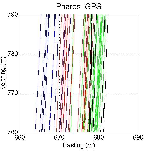
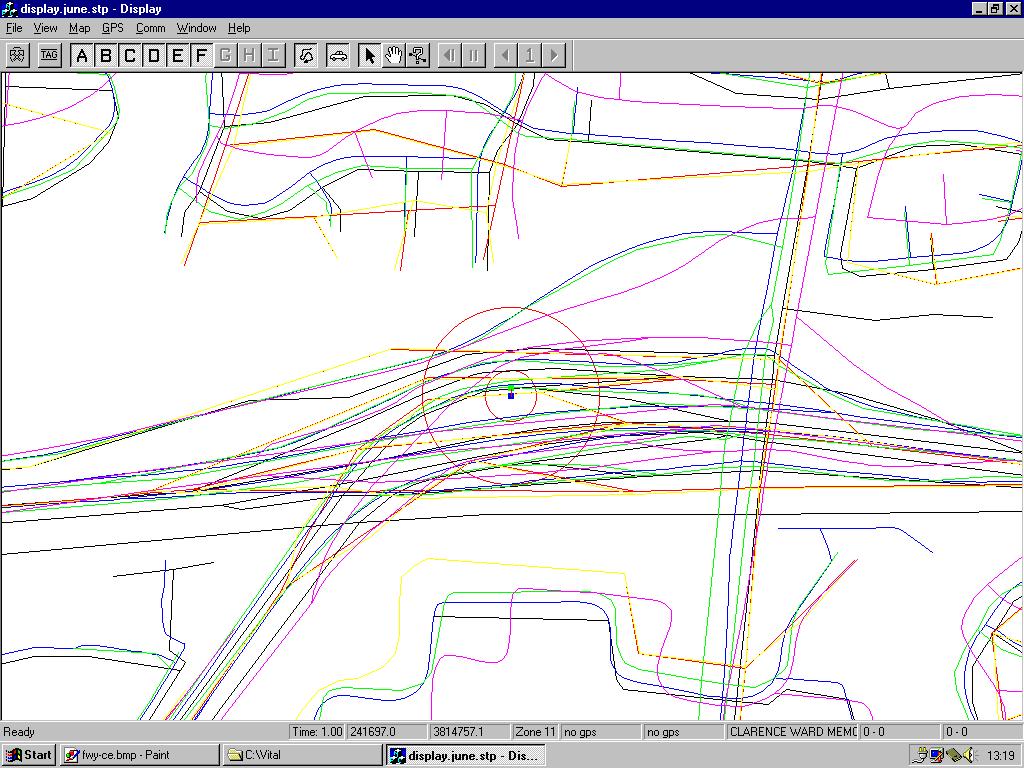
12 GPS tracks as distributions
13 The area class map Assigns every location x to a class Mark and Csillag term c = f(x) a nominal field (or perhaps ordinal) classified scene soil map, vegetation cover map, land use map Need to model uncertainty in this type of map
14
15 Uncertainty modeling Area-class maps are made by a long and complex process involving many stages, some partially subjective Maps of the same theme for the same area will not be the same level of detail, generalization vague definitions of classes variation among observers measuring instrument error different classifiers, training sites different sensors
16 Error and uncertainty Error: true map plus distortion systematic measurements disturbed by stochastic effects accuracy (deviation from true value) precision (deviation from mean value) variation ascribed to error Uncertainty: differences reflect uncertainty about the real world no true map possible consensus map combining maps can improve estimates
17 Models of uncertainty Determine effects of uncertainty/variation/error on results of analysis if there is known variation, the results of a single analysis cannot be claimed to be correct uncertainty analysis an essential part of GIS error model the preferred term
18 Traditional error analysis Measurements subject to distortion z' = z + δz Propagate through transformations r = f(z) r + δr = f(z + δz) But f is rarely known complex compilation and interpretation complex spatial dependencies between elements of resulting data set
19 Spatial dependence In true values z In errors e cov(e i,e j ) a decreasing positive function of distance geostatistical framework Scale effects, generalization as convolutions of z
20 If this were not true If Tobler s First Law of Geography did not apply to errors in maps If errors were statistically independent If relative errors were as large as absolute errors Errors in derived products would be impossibly large e.g. slope e.g. length Shapes would be unrecognizable
21
22 Realization A single instance from an error model an error model must be stochastic Monte Carlo simulation The Gaussian distribution metaphor scalar realizations a Gaussian distribution for maps an entire map as a realization
23 The area class map Field of nominal values c(x), n>1 spatially autocorrelated in raster, count of i,i joins greater than expected In vector, collection of discrete objects nodes, edges, areas in coverage model polygons in shapefile model
24 A collection of discrete objects Three conflicts with the observed nature of area-class maps In repeated mappings, positions, attributes, and numbers of objects will vary (topological variation) Positional uncertainties will vary widely depending on boundary clarity Confusion of attributes will vary within polygons may be greatest in the center contrary to the egg-yolk model
25 suburban core land use type urban
26


27 Six requirements of an error model for area-class maps 1. Address confusion at every point between observed class c' and consensus class c 2. Variation between realizations should emulate variation between repeated mappings 3. Autocorrelations in outcomes at nearby points 4. Emulate effects when maps are generalized, both thematically and cartographically
28 Continued requirements: 5. Realizations should be invariant under changes in underlying representation, e.g., raster cell size 6. Nominal case: results invariant under reordering of classes Review known models against these requirements
29 1. The confusion matrix Useful descriptive device quality control Comparing classifiers, observers, scales, accuracies p(c' c) Applied per-pixel or per-polygon Per-polygon case: no within-polygon variation (violates 1) no variation in topology (violates 2) Per-pixel case: no spatial dependence in outcomes (violates 3, 5)
30 2. The epsilon band Addresses only positional accuracy in a fixed topology Assumes uniform degree of positional accuracy Violates 1, 2, 4
31

32 Models based on vectors of probabilities At every location: P(x) = {p 1,p 2,...,p n } assume raster representation, P constant over cell Simple random assignment no spatial dependence violates 3 violates 5 since cell size would be evident in outcomes How to induce spatial dependence?

33 Spatial dependence in outcomes Independent outcomes zero spatial dependence between pixels perfect positive spatial dependence within pixels implies pixel size is meaningful Induce spatial dependence range >> pixel size spatial dependence falls smoothly independent of pixel size
34 3. Simple convolution Generate independent outcomes in each pixel Convolve using a modal filter induces spatial dependence size of filter determines range of dependence satisfies 3, 5 Posterior proportions not equal to prior probabilities convolution favors more probable classes
35 4. Sequential assignment Goodchild, Sun, and Yang IJGIS (1992) Random field z with controlled spatial dependence U(0,1) assign class e.g. {0.2,0.3,0.5} 1 (0.0,0.2); 2 (0.2,0.5); 3 (0.5,1.0) z = 0.1, c = 1 z = 0.3, c = 2 z = 0.8, c = 3

36 Comparing to criteria 1. Within-polygon variation: yes 2. Topological variation: yes 3. Spatial dependence: yes 4. Generalization: increase cell size, smooth z, smooth P 5. Independent of cell size: yes 6. Invariant under reordering: no
37
38 Indicator Kriging Assign Class 1, notclass 1 Among notclass 1, assign Class 2, notclass 2 Continue to Class n-1 notclass n-1 = Class n
39
40 Process-based interpretation Class i antecedent to class i-1 e.g. agriculture invaded by urban e.g. grassland invaded by forest shape of boundary between class i and class i-1 determined by class i some applications have inherently ordered classes but in this model all classes are ordered
41 5. Shuffling across realizations Shuffling within realizations unacceptable because of heterogeneity Generate N realizations with random assignment Establish target spatial dependencies Pick random pixel pick random pair of realizations swap if closer to target in both realizations
42
43 Properties No justifying interpretation it works Spatial dependence characterized at pixel level no generalization possible, violating 4 It satisfies all other criteria
44 6. Phase-space model m dimensional "phase" space defined by field variables partition into n regions Generate m random fields to locate x in phase space Assign x to one of n classes compare classifiers Goodchild and Dubuc (1987)
45 z 1 (x) z 2 (x) z 3 (x) z 2 c=2 c=4 c=1 c=3 z
46 Properties of the model No specification of P(x) two versions of the model Independent generation of z in each realization no memory between realizations constant proportions Fix z and generate distortions in each realization memory determined by z not by P varying proportions size of distortion determines amount of variation between realizations
47 Properties of the model Only classes adjacent in phase space can be adjacent geographically Classifiers provide obvious basis but how to calibrate variances, covariances of random fields? how to calibrate in other cases? model is over-specified but strongly motivated by process All criteria satisfied generalization by smoothing z, coarsening phasespace classification

48 Conclusions Understanding of uncertainty should be process-based phase space ordinal field Spatial dependence and topological variation are critical for applications missing in the simpler models Some useful methods shuffling most practical phase space most satisfying
Uncertainty in Geographic Information: House of Cards? Michael F. Goodchild University of California Santa Barbara
 Uncertainty in Geographic Information: House of Cards? Michael F. Goodchild University of California Santa Barbara Starting points All geospatial data leave the user to some extent uncertain about the
Types of spatial data. The Nature of Geographic Data. Types of spatial data. Spatial Autocorrelation. Continuous spatial data: geostatistics
 The Nature of Geographic Data Types of spatial data Continuous spatial data: geostatistics Samples may be taken at intervals, but the spatial process is continuous e.g. soil quality Discrete data Irregular:
ENGRG Introduction to GIS
 ENGRG 59910 Introduction to GIS Michael Piasecki October 13, 2017 Lecture 06: Spatial Analysis Outline Today Concepts What is spatial interpolation Why is necessary Sample of interpolation (size and pattern)
Representation of Geographic Data
 GIS 5210 Week 2 The Nature of Spatial Variation Three principles of the nature of spatial variation: proximity effects are key to understanding spatial variation issues of geographic scale and level of
Accuracy and Uncertainty
 Accuracy and Uncertainty Accuracy and Uncertainty Why is this an issue? What is meant by accuracy and uncertainty (data vs rule)? How things have changed in a digital world. Spatial data quality issues
A General Framework for Conflation
 A General Framework for Conflation Benjamin Adams, Linna Li, Martin Raubal, Michael F. Goodchild University of California, Santa Barbara, CA, USA Email: badams@cs.ucsb.edu, linna@geog.ucsb.edu, raubal@geog.ucsb.edu,
Lecture 5 Geostatistics
 Lecture 5 Geostatistics Lecture Outline Spatial Estimation Spatial Interpolation Spatial Prediction Sampling Spatial Interpolation Methods Spatial Prediction Methods Interpolating Raster Surfaces with
Deriving Uncertainty of Area Estimates from Satellite Imagery using Fuzzy Land-cover Classification
 International Journal of Information and Computation Technology. ISSN 0974-2239 Volume 3, Number 10 (2013), pp. 1059-1066 International Research Publications House http://www. irphouse.com /ijict.htm Deriving
Geostatistics and Spatial Scales
 Geostatistics and Spatial Scales Semivariance & semi-variograms Scale dependence & independence Ranges of spatial scales Variable dependent Fractal dimension GIS implications Spatial Modeling Spatial Analysis
The Nature and Value of Geographic Information. Michael F. Goodchild University of California Santa Barbara
 The Nature and Value of Geographic Information Michael F. Goodchild University of California Santa Barbara What is the GI in GIScience?! Is information stuff? if it is, then it must be possible to measure
Software. People. Data. Network. What is GIS? Procedures. Hardware. Chapter 1
 People Software Data Network Procedures Hardware What is GIS? Chapter 1 Why use GIS? Mapping Measuring Monitoring Modeling Managing Five Ms of Applied GIS Chapter 2 Geography matters Quantitative analyses
Quality and Coverage of Data Sources
 Quality and Coverage of Data Sources Objectives Selecting an appropriate source for each item of information to be stored in the GIS database is very important for GIS Data Capture. Selection of quality
Lecture 8. Spatial Estimation
 Lecture 8 Spatial Estimation Lecture Outline Spatial Estimation Spatial Interpolation Spatial Prediction Sampling Spatial Interpolation Methods Spatial Prediction Methods Interpolating Raster Surfaces
Basics of GIS. by Basudeb Bhatta. Computer Aided Design Centre Department of Computer Science and Engineering Jadavpur University
 Basics of GIS by Basudeb Bhatta Computer Aided Design Centre Department of Computer Science and Engineering Jadavpur University e-governance Training Programme Conducted by National Institute of Electronics
Improving Spatial Data Interoperability
 Improving Spatial Data Interoperability A Framework for Geostatistical Support-To To-Support Interpolation Michael F. Goodchild, Phaedon C. Kyriakidis, Philipp Schneider, Matt Rice, Qingfeng Guan, Jordan
Spatial Concepts: Data Models 2
 Spatial Concepts: Data Models 2 2009/2010 CGI GIRS 2/31 Data modeling in 4 steps 1. Geographical perception Continuous phenomenon Discrete phenomena Virtual boundaries Tangible boundaries altitude, EM
Luc Anselin Spatial Analysis Laboratory Dept. Agricultural and Consumer Economics University of Illinois, Urbana-Champaign
 GIS and Spatial Analysis Luc Anselin Spatial Analysis Laboratory Dept. Agricultural and Consumer Economics University of Illinois, Urbana-Champaign http://sal.agecon.uiuc.edu Outline GIS and Spatial Analysis
UNCERTAINTY AND ERRORS IN GIS
 Christos G. Karydas,, Dr. xkarydas@agro.auth.gr http://users.auth.gr/xkarydas Lab of Remote Sensing and GIS Director: Prof. N. Silleos School of Agriculture Aristotle University of Thessaloniki, GR 1 UNCERTAINTY
Visualizing Spatial Uncertainty of Multinomial Classes in Area-class Mapping
 Visualizing Spatial Uncertainty of Multinomial Classes in Area-class Mapping Weidong Li Chuanrong Zhang* Department of Geography, Kent State University, Kent, OH 44242 *Chuanrong Zhang Email: zhangc@uww.edu
Michael Harrigan Office hours: Fridays 2:00-4:00pm Holden Hall
 Announcement New Teaching Assistant Michael Harrigan Office hours: Fridays 2:00-4:00pm Holden Hall 209 Email: michael.harrigan@ttu.edu Guofeng Cao, Texas Tech GIST4302/5302, Lecture 2: Review of Map Projection
Sampling The World. presented by: Tim Haithcoat University of Missouri Columbia
 Sampling The World presented by: Tim Haithcoat University of Missouri Columbia Compiled with materials from: Charles Parson, Bemidji State University and Timothy Nyerges, University of Washington Introduction
Overview of Statistical Analysis of Spatial Data
 Overview of Statistical Analysis of Spatial Data Geog 2C Introduction to Spatial Data Analysis Phaedon C. Kyriakidis www.geog.ucsb.edu/ phaedon Department of Geography University of California Santa Barbara
KNOWLEDGE-BASED CLASSIFICATION OF LAND COVER FOR THE QUALITY ASSESSEMENT OF GIS DATABASE. Israel -
 KNOWLEDGE-BASED CLASSIFICATION OF LAND COVER FOR THE QUALITY ASSESSEMENT OF GIS DATABASE Ammatzia Peled a,*, Michael Gilichinsky b a University of Haifa, Department of Geography and Environmental Studies,
Geography 38/42:376 GIS II. Topic 1: Spatial Data Representation and an Introduction to Geodatabases. The Nature of Geographic Data
 Geography 38/42:376 GIS II Topic 1: Spatial Data Representation and an Introduction to Geodatabases Chapters 3 & 4: Chang (Chapter 4: DeMers) The Nature of Geographic Data Features or phenomena occur as
Introduction to GIS. Phil Guertin School of Natural Resources and the Environment GeoSpatial Technologies
 Introduction to GIS Phil Guertin School of Natural Resources and the Environment dguertin@cals.arizona.edu Mapping GeoSpatial Technologies Traditional Survey Global Positioning Systems (GPS) Remote Sensing
POPULAR CARTOGRAPHIC AREAL INTERPOLATION METHODS VIEWED FROM A GEOSTATISTICAL PERSPECTIVE
 CO-282 POPULAR CARTOGRAPHIC AREAL INTERPOLATION METHODS VIEWED FROM A GEOSTATISTICAL PERSPECTIVE KYRIAKIDIS P. University of California Santa Barbara, MYTILENE, GREECE ABSTRACT Cartographic areal interpolation
GIST 4302/5302: Spatial Analysis and Modeling
 GIST 4302/5302: Spatial Analysis and Modeling Review Guofeng Cao www.gis.ttu.edu/starlab Department of Geosciences Texas Tech University guofeng.cao@ttu.edu Spring 2016 Course Outlines Spatial Point Pattern
SVY2001: Lecture 15: Introduction to GIS and Attribute Data
 SVY2001: Databases for GIS Lecture 15: Introduction to GIS and Attribute Data Management. Dr Stuart Barr School of Civil Engineering & Geosciences University of Newcastle upon Tyne. Email: S.L.Barr@ncl.ac.uk
GIS and Spatial Statistics: One World View or Two? Michael F. Goodchild University of California Santa Barbara
 GIS and Spatial Statistics: One World View or Two? Michael F. Goodchild University of California Santa Barbara Location as attribute The data table Census summary table What value is location as an explanatory
Geog 469 GIS Workshop. Data Analysis
 Geog 469 GIS Workshop Data Analysis Outline 1. What kinds of need-to-know questions can be addressed using GIS data analysis? 2. What is a typology of GIS operations? 3. What kinds of operations are useful
Data Accuracy to Data Quality: Using spatial statistics to predict the implications of spatial error in point data
 This file was created by scanning the printed publication. Errors identified by the software have been corrected; however, some errors may remain. Data Accuracy to Data Quality: Using spatial statistics
The Nature of Geographic Data
 4 The Nature of Geographic Data OVERVIEW Elaborates on the spatial is special theme Focuses on how phenomena vary across space and the general nature of geographic variation Describes the main principles
Introduction-Overview. Why use a GIS? What can a GIS do? Spatial (coordinate) data model Relational (tabular) data model
 data model Relational (tabular) data model") Introduction-Overview Why use a GIS? What can a GIS do? How does a GIS work? GIS definitions Spatial (coordinate) data model Relational (tabular) data model intro_gis.ppt 1 Why use a GIS? An extension
Introduction-Overview Why use a GIS? What can a GIS do? How does a GIS work? GIS definitions Spatial (coordinate) data model Relational (tabular) data model intro_gis.ppt 1 Why use a GIS? An extension
Object-based feature extraction of Google Earth Imagery for mapping termite mounds in Bahia, Brazil
 OPEN ACCESS Conference Proceedings Paper Sensors and Applications www.mdpi.com/journal/sensors Object-based feature extraction of Google Earth Imagery for mapping termite mounds in Bahia, Brazil Sunhui
Spatial Process VS. Non-spatial Process. Landscape Process
 Spatial Process VS. Non-spatial Process A process is non-spatial if it is NOT a function of spatial pattern = A process is spatial if it is a function of spatial pattern Landscape Process If there is no
Introduction to GIS I
 Introduction to GIS Introduction How to answer geographical questions such as follows: What is the population of a particular city? What are the characteristics of the soils in a particular land parcel?
MODELING DEM UNCERTAINTY IN GEOMORPHOMETRIC APPLICATIONS WITH MONTE CARLO-SIMULATION
 MODELING DEM UNCERTAINTY IN GEOMORPHOMETRIC APPLICATIONS WITH MONTE CARLO-SIMULATION Juha Oksanen and Tapani Sarjakoski Finnish Geodetic Institute Department of Geoinformatics and Cartography P.O. Box
2.2 Geographic phenomena
 2.2. Geographic phenomena 66 2.2 Geographic phenomena 2.2. Geographic phenomena 67 2.2.1 Defining geographic phenomena A GIS operates under the assumption that the relevant spatial phenomena occur in a
Spatial Decision Tree: A Novel Approach to Land-Cover Classification
 Spatial Decision Tree: A Novel Approach to Land-Cover Classification Zhe Jiang 1, Shashi Shekhar 1, Xun Zhou 1, Joseph Knight 2, Jennifer Corcoran 2 1 Department of Computer Science & Engineering 2 Department
Cell-based Model For GIS Generalization
 Cell-based Model For GIS Generalization Bo Li, Graeme G. Wilkinson & Souheil Khaddaj School of Computing & Information Systems Kingston University Penrhyn Road, Kingston upon Thames Surrey, KT1 2EE UK
Geographical Information Systems
 Geographical Information Systems Geographical Information Systems (GIS) is a relatively new technology that is now prominent in the ecological sciences. This tool allows users to map geographic features
GIST 4302/5302: Spatial Analysis and Modeling
 GIST 4302/5302: Spatial Analysis and Modeling Lecture 2: Review of Map Projections and Intro to Spatial Analysis Guofeng Cao http://thestarlab.github.io Department of Geosciences Texas Tech University
UNCERTAINTY EVALUATION OF MILITARY TERRAIN ANALYSIS RESULTS BY SIMULATION AND VISUALIZATION
 Geoinformatics 2004 Proc. 12th Int. Conf. on Geoinformatics Geospatial Information Research: Bridging the Pacific and Atlantic University of Gävle, Sweden, 7-9 June 2004 UNCERTAINTY EVALUATION OF MILITARY
Propagation of Errors in Spatial Analysis
 Stephen F. Austin State University SFA ScholarWorks Faculty Presentations Spatial Science 2001 Propagation of Errors in Spatial Analysis Peter P. Siska I-Kuai Hung Arthur Temple College of Forestry and
Advanced analysis and modelling tools for spatial environmental data. Case study: indoor radon data in Switzerland
 EnviroInfo 2004 (Geneva) Sh@ring EnviroInfo 2004 Advanced analysis and modelling tools for spatial environmental data. Case study: indoor radon data in Switzerland Mikhail Kanevski 1, Michel Maignan 1
GEOGRAPHY 350/550 Final Exam Fall 2005 NAME:
 1) A GIS data model using an array of cells to store spatial data is termed: a) Topology b) Vector c) Object d) Raster 2) Metadata a) Usually includes map projection, scale, data types and origin, resolution
A spatial literacy initiative for undergraduate education at UCSB
 A spatial literacy initiative for undergraduate education at UCSB Mike Goodchild & Don Janelle Department of Geography / spatial@ucsb University of California, Santa Barbara ThinkSpatial Brown bag forum
An Information Model for Maps: Towards Cartographic Production from GIS Databases
 An Information Model for s: Towards Cartographic Production from GIS Databases Aileen Buckley, Ph.D. and Charlie Frye Senior Cartographic Researchers, ESRI Barbara Buttenfield, Ph.D. Professor, University
CyberGIS: What Still Needs to Be Done? Michael F. Goodchild University of California Santa Barbara
 CyberGIS: What Still Needs to Be Done? Michael F. Goodchild University of California Santa Barbara Progress to date Interoperable location referencing coordinate transformations geocoding addresses point-of-interest
Introduction to Spatial Statistics and Modeling for Regional Analysis
 Introduction to Spatial Statistics and Modeling for Regional Analysis Dr. Xinyue Ye, Assistant Professor Center for Regional Development (Department of Commerce EDA University Center) & School of Earth,
VISUAL ANALYTICS APPROACH FOR CONSIDERING UNCERTAINTY INFORMATION IN CHANGE ANALYSIS PROCESSES
 VISUAL ANALYTICS APPROACH FOR CONSIDERING UNCERTAINTY INFORMATION IN CHANGE ANALYSIS PROCESSES J. Schiewe HafenCity University Hamburg, Lab for Geoinformatics and Geovisualization, Hebebrandstr. 1, 22297
GEO-DATA INPUT AND CONVERSION. Christos G. Karydas,, Dr. Lab of Remote Sensing and GIS Director: Prof. N. Silleos
 Christos G. Karydas,, Dr. xkarydas@agro.auth.gr http://users.auth.gr/xkarydas Lab of Remote Sensing and GIS Director: Prof. N. Silleos School of Agriculture Aristotle University of Thessaloniki, GR 1 0.
Lecture 1: Geospatial Data Models
 Lecture 1: GEOG413/613 Dr. Anthony Jjumba Introduction Course Outline Journal Article Review Projects (and short presentations) Final Exam (April 3) Participation in class discussions Geog413/Geog613 A
30 YEARS SINCE Z_GIS FOUNDING: PROVIDING SOLUTIONS FOR SOCIETY AND BUSINESS
 30 YEARS SINCE Z_GIS FOUNDING: PROVIDING SOLUTIONS FOR SOCIETY AND BUSINESS Michael F Goodchild Emeritus Professor of Geography University of California, Santa Barbara Keynote GIScience Symposium, Salzburg,
NR402 GIS Applications in Natural Resources. Lesson 9: Scale and Accuracy
 NR402 GIS Applications in Natural Resources Lesson 9: Scale and Accuracy 1 Map scale Map scale specifies the amount of reduction between the real world and the map The map scale specifies how much the
GIST 4302/5302: Spatial Analysis and Modeling Lecture 2: Review of Map Projections and Intro to Spatial Analysis
 GIST 4302/5302: Spatial Analysis and Modeling Lecture 2: Review of Map Projections and Intro to Spatial Analysis Guofeng Cao http://www.spatial.ttu.edu Department of Geosciences Texas Tech University guofeng.cao@ttu.edu
The Generalized Likelihood Uncertainty Estimation methodology
 CHAPTER 4 The Generalized Likelihood Uncertainty Estimation methodology Calibration and uncertainty estimation based upon a statistical framework is aimed at finding an optimal set of models, parameters
8/28/2011. Contents. Lecture 1: Introduction to GIS. Dr. Bo Wu Learning Outcomes. Map A Geographic Language.
 Contents Lecture 1: Introduction to GIS Dr. Bo Wu lsbowu@polyu.edu.hk Department of Land Surveying & Geo-Informatics The Hong Kong Polytechnic University 1. Learning outcomes 2. GIS definition 3. GIS examples
Introduction to GIS - 2
 Introduction to GIS - 2 Outline Using GIS Representation of spatial objects in GIS Prof. D. Nagesh Kumar Department of Civil Engineering Indian Institute of Science Bangalore 560 012, India http://www.civil.iisc.ernet.in/~nagesh
Reference Database and Validation Concept for Remote Sensing based Forest Cover Change Products in Fiji INTERNATIONAL CLIMATE INITIATIVE
 INTERNATIONAL CLIMATE INITIATIVE Regional project Climate Protection through Forest Conservation in Pacific Island Countries Reference Database and Validation Concept for Remote Sensing based Forest Cover
SPACE Workshop NSF NCGIA CSISS UCGIS SDSU. Aldstadt, Getis, Jankowski, Rey, Weeks SDSU F. Goodchild, M. Goodchild, Janelle, Rebich UCSB
 SPACE Workshop NSF NCGIA CSISS UCGIS SDSU Aldstadt, Getis, Jankowski, Rey, Weeks SDSU F. Goodchild, M. Goodchild, Janelle, Rebich UCSB August 2-8, 2004 San Diego State University Some Examples of Spatial
Impacts of sensor noise on land cover classifications: sensitivity analysis using simulated noise
 Impacts of sensor noise on land cover classifications: sensitivity analysis using simulated noise Scott Mitchell 1 and Tarmo Remmel 2 1 Geomatics & Landscape Ecology Research Lab, Carleton University,
Geographic Information Systems (GIS) in Environmental Studies ENVS Winter 2003 Session III
 in Environmental Studies ENVS Winter 2003 Session III") Geographic Information Systems (GIS) in Environmental Studies ENVS 6189 3.0 Winter 2003 Session III John Sorrell York University sorrell@yorku.ca Session Purpose: To discuss the various concepts of space,
Geographic Information Systems (GIS) in Environmental Studies ENVS 6189 3.0 Winter 2003 Session III John Sorrell York University sorrell@yorku.ca Session Purpose: To discuss the various concepts of space,
Lecture 5. Symbolization and Classification MAP DESIGN: PART I. A picture is worth a thousand words
 Lecture 5 MAP DESIGN: PART I Symbolization and Classification A picture is worth a thousand words Outline Symbolization Types of Maps Classifying Features Visualization Considerations Symbolization Symbolization
Interpolating Raster Surfaces
 Interpolating Raster Surfaces You can use interpolation to model the surface of a feature or a phenomenon all you need are sample points, an interpolation method, and an understanding of the feature or
A Basic Introduction to Geographic Information Systems (GIS) ~~~~~~~~~~
 ~~~~~~~~~~") A Basic Introduction to Geographic Information Systems (GIS) ~~~~~~~~~~ Rev. Ronald J. Wasowski, C.S.C. Associate Professor of Environmental Science University of Portland Portland, Oregon 3 September
A Basic Introduction to Geographic Information Systems (GIS) ~~~~~~~~~~ Rev. Ronald J. Wasowski, C.S.C. Associate Professor of Environmental Science University of Portland Portland, Oregon 3 September
Integrating LiDAR data into the workflow of cartographic representation.
 Integrating LiDAR data into the workflow of cartographic representation. Cartographic Workflow I. 1 2 3 4 5 Surveying Vector (Nat. GDB) GPS, Laser Range Finder Yes/ No Scanning old maps LiDARflights Capture
Areal Differentiation Using Fuzzy Set Membership and Support Logic
 Areal Differentiation Using Fuzzy Set Membership and Support Logic Michael N. DeMers ABSTRACT: Qualitative thematic maps are graphic representations of the process of areal differentiation, a process recognized
Dynamic Multipath Estimation by Sequential Monte Carlo Methods
 Dynamic Multipath Estimation by Sequential Monte Carlo Methods M. Lentmaier, B. Krach, P. Robertson, and T. Thiasiriphet German Aerospace Center (DLR) Slide 1 Outline Multipath problem and signal model
Understanding Geographic Information System GIS
 Understanding Geographic Information System GIS What do we know about GIS? G eographic I nformation Maps Data S ystem Computerized What do we know about maps? Types of Maps (Familiar Examples) Street Maps
Introducing GIS analysis
 1 Introducing GIS analysis GIS analysis lets you see patterns and relationships in your geographic data. The results of your analysis will give you insight into a place, help you focus your actions, or
F denotes cumulative density. denotes probability density function; (.)
") BAYESIAN ANALYSIS: FOREWORDS Notation. System means the real thing and a model is an assumed mathematical form for the system.. he probability model class M contains the set of the all admissible models
BAYESIAN ANALYSIS: FOREWORDS Notation. System means the real thing and a model is an assumed mathematical form for the system.. he probability model class M contains the set of the all admissible models
USING LANDSAT IN A GIS WORLD
 USING LANDSAT IN A GIS WORLD RACHEL MK HEADLEY; PHD, PMP STEM LIAISON, ACADEMIC AFFAIRS BLACK HILLS STATE UNIVERSITY This material is based upon work supported by the National Science Foundation under
Spatial Analysis and Modeling (GIST 4302/5302) Guofeng Cao Department of Geosciences Texas Tech University
 Guofeng Cao Department of Geosciences Texas Tech University") Spatial Analysis and Modeling (GIST 4302/5302) Guofeng Cao Department of Geosciences Texas Tech University TTU Graduate Certificate Geographic Information Science and Technology (GIST) 3 Core Courses and
Spatial Analysis and Modeling (GIST 4302/5302) Guofeng Cao Department of Geosciences Texas Tech University TTU Graduate Certificate Geographic Information Science and Technology (GIST) 3 Core Courses and
Modeling Urban Sprawl: from Raw TIGER Data with GIS
 Modeling Urban Sprawl: from Raw TIGER Data with GIS Brady Foust University of Wisconsin-Eau Claire Lisa Theo University of Wisconsin-Stevens Point Modeling Urban Sprawl 1 Problem How to model & predict
Raster Spatial Analysis Specific Theory
 RSATheory.doc 1 Raster Spatial Analysis Specific Theory... 1 Spatial resampling... 1 Mosaic... 3 Reclassification... 4 Slicing... 4 Zonal Operations... 5 References... 5 Raster Spatial Analysis Specific
Remote sensing of sealed surfaces and its potential for monitoring and modeling of urban dynamics
 Remote sensing of sealed surfaces and its potential for monitoring and modeling of urban dynamics Frank Canters CGIS Research Group, Department of Geography Vrije Universiteit Brussel Herhaling titel van
Spatial Data Mining. Regression and Classification Techniques
 Spatial Data Mining Regression and Classification Techniques 1 Spatial Regression and Classisfication Discrete class labels (left) vs. continues quantities (right) measured at locations (2D for geographic
GIST 4302/5302: Spatial Analysis and Modeling
 GIST 4302/5302: Spatial Analysis and Modeling Basics of Statistics Guofeng Cao www.myweb.ttu.edu/gucao Department of Geosciences Texas Tech University guofeng.cao@ttu.edu Spring 2015 Outline of This Week
INTRODUCTION TO PATTERN RECOGNITION
 INTRODUCTION TO PATTERN RECOGNITION INSTRUCTOR: WEI DING 1 Pattern Recognition Automatic discovery of regularities in data through the use of computer algorithms With the use of these regularities to take
Particle Filters. Pieter Abbeel UC Berkeley EECS. Many slides adapted from Thrun, Burgard and Fox, Probabilistic Robotics
 Particle Filters Pieter Abbeel UC Berkeley EECS Many slides adapted from Thrun, Burgard and Fox, Probabilistic Robotics Motivation For continuous spaces: often no analytical formulas for Bayes filter updates
Statistics Boot Camp. Dr. Stephanie Lane Institute for Defense Analyses DATAWorks 2018
 Statistics Boot Camp Dr. Stephanie Lane Institute for Defense Analyses DATAWorks 2018 March 21, 2018 Outline of boot camp Summarizing and simplifying data Point and interval estimation Foundations of statistical
Nature of Spatial Data. Outline. Spatial Is Special
 Nature of Spatial Data Outline Spatial is special Bad news: the pitfalls of spatial data Good news: the potentials of spatial data Spatial Is Special Are spatial data special? Why spatial data require
An Introduction to Geographic Information System
 An Introduction to Geographic Information System PROF. Dr. Yuji MURAYAMA Khun Kyaw Aung Hein 1 July 21,2010 GIS: A Formal Definition A system for capturing, storing, checking, Integrating, manipulating,
Intro to GIS Summer 2012 Data Visualization
 Intro to GIS Summer 2012 Data Visualization UNDERSTANDING YOUR MAP DATA Qualitative vs. Quantitative Data Qualitative Data classified by category e.g. Soil types, Animal Species Quantitative Data grouped
Geographically weighted methods for examining the spatial variation in land cover accuracy
 Geographically weighted methods for examining the spatial variation in land cover accuracy Alexis Comber 1, Peter Fisher 1, Chris Brunsdon 2, Abdulhakim Khmag 1 1 Department of Geography, University of
Twenty Years of Progress: GIScience in Michael F. Goodchild University of California Santa Barbara
 Twenty Years of Progress: GIScience in 2010 Michael F. Goodchild University of California Santa Barbara Outline The beginnings: GIScience in 1990 Major accomplishments research institutional The future
Geospatial technology for land cover analysis
 Home Articles Application Environment & Climate Conservation & monitoring Published in : Middle East & Africa Geospatial Digest November 2013 Lemenkova Polina Charles University in Prague, Faculty of Science,
Digital Chart Cartography: Error and Quality control
 Digital Chart Cartography: Error and Quality control Di WU (PHD student) Session7: Advances in Cartography Venue: TU 107 Yantai Institute of Coastal Zone Research, CAS, Yantai 264003, ChinaC Key State
Fundamental Spatial Concepts. Michael F. Goodchild University of California Santa Barbara
 Fundamental Spatial Concepts Michael F. Goodchild University of California Santa Barbara A spatial turn in science Adding space to theory the New Economic Geography space impeding flows of information,
PROANA A USEFUL SOFTWARE FOR TERRAIN ANALYSIS AND GEOENVIRONMENTAL APPLICATIONS STUDY CASE ON THE GEODYNAMIC EVOLUTION OF ARGOLIS PENINSULA, GREECE.
 PROANA A USEFUL SOFTWARE FOR TERRAIN ANALYSIS AND GEOENVIRONMENTAL APPLICATIONS STUDY CASE ON THE GEODYNAMIC EVOLUTION OF ARGOLIS PENINSULA, GREECE. Spyridoula Vassilopoulou * Institute of Cartography
Exploring Digital Earth. Michael F. Goodchild University of California Santa Barbara
 Exploring Digital Earth Michael F. Goodchild University of California Santa Barbara Some explaining to do What a curious career Nevill Mott, Cavendish Professor of Physics, University of Cambridge, 1965
Intensity Analysis of Spatial Point Patterns Geog 210C Introduction to Spatial Data Analysis
 Intensity Analysis of Spatial Point Patterns Geog 210C Introduction to Spatial Data Analysis Chris Funk Lecture 5 Topic Overview 1) Introduction/Unvariate Statistics 2) Bootstrapping/Monte Carlo Simulation/Kernel
Version 1.1 GIS Syllabus
 GEOGRAPHIC INFORMATION SYSTEMS CERTIFICATION Version 1.1 GIS Syllabus Endorsed 1 Version 1 January 2007 GIS Certification Programme 1. Target The GIS certification is aimed at: Those who wish to demonstrate
Practical Bayesian Optimization of Machine Learning. Learning Algorithms
 Practical Bayesian Optimization of Machine Learning Algorithms CS 294 University of California, Berkeley Tuesday, April 20, 2016 Motivation Machine Learning Algorithms (MLA s) have hyperparameters that
Transiogram: A spatial relationship measure for categorical data
 International Journal of Geographical Information Science Vol. 20, No. 6, July 2006, 693 699 Technical Note Transiogram: A spatial relationship measure for categorical data WEIDONG LI* Department of Geography,
[Figure 1 about here]
![[Figure 1 about here]](/thumbs/87/95828660.jpg "[Figure 1 about here]") TITLE: FIELD-BASED SPATIAL MODELING BYLINE: Michael F. Goodchild, University of California, Santa Barbara, www.geog.ucsb.edu/~good SYNONYMS: None DEFINITION: A field (or continuous field) is defined as
TITLE: FIELD-BASED SPATIAL MODELING BYLINE: Michael F. Goodchild, University of California, Santa Barbara, www.geog.ucsb.edu/~good SYNONYMS: None DEFINITION: A field (or continuous field) is defined as
Computer Vision Group Prof. Daniel Cremers. 14. Sampling Methods
 Prof. Daniel Cremers 14. Sampling Methods Sampling Methods Sampling Methods are widely used in Computer Science as an approximation of a deterministic algorithm to represent uncertainty without a parametric
Fundamentals of ArcGIS Desktop Pathway
 Fundamentals of ArcGIS Desktop Pathway Table of Contents ArcGIS Desktop I: Getting Started with GIS 3 ArcGIS Desktop II: Tools and Functionality 5 Understanding Geographic Data 8 Understanding Map Projections
Results: MCMC Dancers, q=10, n=500
 Motivation Sampling Methods for Bayesian Inference How to track many INTERACTING targets? A Tutorial Frank Dellaert Results: MCMC Dancers, q=10, n=500 1 Probabilistic Topological Maps Results Real-Time