Geog 469 GIS Workshop. Data Analysis
|
|
|
- Cora Sherman
- 5 years ago
- Views:
Transcription
1 Geog 469 GIS Workshop Data Analysis
2 Outline 1. What kinds of need-to-know questions can be addressed using GIS data analysis? 2. What is a typology of GIS operations? 3. What kinds of operations are useful for data manipulation? 4. What kinds of operations are useful for data analysis 5. What is the difference between analysis and modeling? 6. How does workflow help organize operations?
3 1. What kinds of need-to-know questions can be addressed using GIS data analysis?
4 Need-to-know questions Location - Where is the phenomenon? - Where does it occur? Extent - How far does it extend already? - Where are its limits? Distribution - Is there regularity or randomness in its spatial distribution? - What is the nature of that regularity? Pattern - Why does it take a particular pattern (form or structure) that it has? - Why should the spatial distributional pattern exhibit regularity? Association - What else is there spatially associated with that phenomenon? - Do these things usually occur together in the same places? Change - When did it first emerge or become obvious? - How has it changed spatially (through time)? Diffusion - What factors have influenced its spread? - Why has it spread in this particular way? Based on Nyerges Analytical Map Use, Cartography and Geographic Information Systems
5 2. What is a typology of GIS operations?
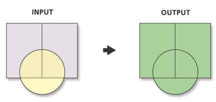
6 Typology of GIS operations Analysis is the core of GIS that transforms data into information INPUT OPERATIONS OUTPUT General typology Data manipulation operations data available operation data ready Data analysis operations data ready operation information to knowledge?
7 Detailed GIS operation typology After Figure 13.6 (Longley, Goodchild, Maguire, Rhind 2005, Geographic Information Systems and Science, p. 296) Interpretation, Validation, Exploration Various steps in workflow Analysis Measurement & manipulation Problem Conception feedback World Many kinds of operations
8 Transformation Framework between object-field(s) and object-field(s) TO: Points Lines Polygons Fields FROM: Points Lines Points->Points Points->Lines Points- >Polygons Points->Fields Lines->Points Lines->Lines Lines->Polygons Lines->Fields Polygons Polygons- >Points Polygons- >Lines Polygons- >Polygons Polygons->Fields Fields Fields->Points Fields->Lines Fields->Polygons Fields->Fields -> means relationship between object-field(s) and object-field(s); a relationship is implemented through a GIS operation (function) From Nyerges and Jankowski (NJ) 2010 Table 6.1
9 Selected Spatial Relationships Six spatial relationships for transformations Connectedness (topologic) Adjacency (topologic) Containment (topologic) Proximity (geometric) Overlap (geometric) Pattern (geometric) In Table 6.1 transformation operations primitive --relationship operation--> primitive Replace --relationship--> with the six relationships above to arrive at those in NJ Table ; how do we implement them?
10 3. What kinds of operations are useful for data manipulation?
11 Data manipulation Data creation Digitizing Vectorization (ArcScan) Data editing Topology editing (in ArcGIS geodatabases create relationships) Raster resampling (co-registering different raster images) Data conversion Export/import (be aware of data loss due to incompatibility) Conversion among coordinate systems Coordinate transformation Registration (control points) Transformations (between spatial surfaces) Rubber-sheeting (least-squares computation)

12 Examples of data manipulation Coordinate transformations Raster resampling Translation

13 Needs for data manipulation Image source: Bolstad 2005 Incompatible cell sizes and boundaries confound multi-layer raster operations. These ambiguities are best resolved by resampling prior to layer combination
14 4. What kinds of operations are useful for data analysis?
15 Data analysis Queries Measure Transformations Descriptive summaries Optimization Modeling Following Longley et al 2005
16 Queries (extract) Attribute queries Select * from table where [condition] Condition: logical expression e.g. Median Age > 45 Spatial queries Select * from layer where [condition] Condition: based on spatial relationship e.g. hospital within King County e.g. hospital 10 kilometers or farther from highway
17 Measure Measure distance, area and parameter of a single feature ArcToolbox or calculate fields Use meaningful measurement unit (by converting geographic coordinate to state plane coordinate) Make use of Python script to measure more complex geometric properties (e.g. a ratio population density) Measure slope and aspect of terrain Work with DEM ArcGIS Spatial Analyst
18 Transformations (vector) Simple spatial analysis that change datasets, combining them or comparing them to obtain new datasets Buffer Spatial overlay point in polygon operations e.g. # parcels within zoning area? polygon in polygon overlay with the added complexity (union, intersect, identity) Other commonly used Clip, dissolve, erase,.

19 union dissolve
20 Transformations (raster) Map algebra for raster Local function (also known as reclassification) Neighborhood function (focal function) filtering Spatial interpolation Deterministic (specific function) : IDW Stochastic (probability) : Kriging Use Geostatistical Analyst for those
21 Descriptive spatial summaries Capture the essence of a dataset in one or two numbers Mean and standard deviation of attributes It may not be included in the process diagram, but useful in gaining an overview of data and determining the appropriate data classification method for thematic mapping Descriptive summaries of spatial features Mean center and dispersion Measure spatial pattern of vector data hot spot detection methods: nearest neighbor, K function Work with point data ArcToolbox - Spatial Statistics Tools CrimeStat (freeware) by National Institute of Justice
22 5. What is the difference between analysis and modeling?
23 Data analysis treats structure models and process models. Spatial modeling generally treats only process models, i.e., models over time. It is a rough distinction, do not worry about being specific, as no one else really is
24 Optimization Problem-solving by optimizing objectives That is, minimize cost or maximize benefit given constraints Find the least cost path Finding the best path based on link-node representation where cost information is attached ArcGIS Desktop performs dynamic segmentation, other software such as TransCAD, ArcGIS Network Analyst work on networks Finding the gradient path based on grid data ArcGIS Spatial Analyst least cost path Location-allocation problems Location for a new retail store, e.g. Starbucks? See EC58.1.2
25 Spatial Modeling Modeling enables us to explore multiple alternatives Evaluate the outcomes of different policy alternatives (i.e. what-if scenario ) Often used for dynamic simulation, providing rich visualizations of alternative futures
26 Spatial modeling Definition 1: A sequence of different operations; aka. cartographic modeling (by Tomlin) What if you want to change parameters and see what happens to outcomes? Want to automate the whole process? ArcGIS ModelBuilder: Run entire workflow with one click Definition 2: Process model embeds operations so as to predict what would happen with given input parameters Range from simple to complex, but emphasize temporal modeling Soil erosion = f (a, b, c, d); housing price = f (a, b, c, d) Hydrological modeling: sequence of logics or rules Test what-if scenarios over time
27 6. How does workflow help organize operations?

28 Workflow Example Location Suitability Using ModelBuilder
29 Nature of Transformations In previous diagram buffer, buffer and recode are based upon spatial data transformation operations - buffer: line to polygon operation - buffer: line to polygon operation - recode: point to point operation Spatial structure influence is the basis of the transformations, wherein time component address externally
 Implement - What? Where? When? Goal: move data, knowledge, and values into action Steinitz, C.")
30 Geodesign modeling workflow Six steps of geodesign analysis answer questions in three passes: 1) Scope - Why? 2) Design - How? 3) Implement - What? Where? When? Goal: move data, knowledge, and values into action Steinitz, C. (2012) A Framework for Geodesign, Redlands, CA: Esri Press.
31 Transformations within Geodesign Workflow Processes The geospatial problem: where to site gray-water facility within Green (King) County ; best place for siting water recycling facility Start with geodesign six stages of modeling For each geodesign stage apply the collection of transformations needed. Details in Nyerges and Jankowski 2010 RUGIS Spatial Data Transformation Tables NJ
32 End
GIS CONCEPTS ARCGIS METHODS AND. 2 nd Edition, July David M. Theobald, Ph.D. Natural Resource Ecology Laboratory Colorado State University
 GIS CONCEPTS AND ARCGIS METHODS 2 nd Edition, July 2005 David M. Theobald, Ph.D. Natural Resource Ecology Laboratory Colorado State University Copyright Copyright 2005 by David M. Theobald. All rights
GIS CONCEPTS ARCGIS METHODS AND. 3 rd Edition, July David M. Theobald, Ph.D. Warner College of Natural Resources Colorado State University
 GIS CONCEPTS AND ARCGIS METHODS 3 rd Edition, July 2007 David M. Theobald, Ph.D. Warner College of Natural Resources Colorado State University Copyright Copyright 2007 by David M. Theobald. All rights
Overview key concepts and terms (based on the textbook Chang 2006 and the practical manual)
") Introduction Geo-information Science (GRS-10306) Overview key concepts and terms (based on the textbook 2006 and the practical manual) Introduction Chapter 1 Geographic information system (GIS) Geographically
Introduction Geo-information Science (GRS-10306) Overview key concepts and terms (based on the textbook 2006 and the practical manual) Introduction Chapter 1 Geographic information system (GIS) Geographically
SPATIAL MODELING GIS Analysis Winter 2016
 SPATIAL MODELING GIS Analysis Winter 2016 Spatial Models Spatial Modeling attempts to represent how the world works All models are wrong, but some are useful (G.E. Box, quoted in course textbook pg. 379)
ArcGIS Pro: Analysis and Geoprocessing. Nicholas M. Giner Esri Christopher Gabris Blue Raster
 ArcGIS Pro: Analysis and Geoprocessing Nicholas M. Giner Esri Christopher Gabris Blue Raster Agenda What is Analysis and Geoprocessing? Analysis in ArcGIS Pro - 2D (Spatial xy) - 3D (Elevation - z) - 4D
Chapter 6. Fundamentals of GIS-Based Data Analysis for Decision Support. Table 6.1. Spatial Data Transformations by Geospatial Data Types
 Chapter 6 Fundamentals of GIS-Based Data Analysis for Decision Support FROM: Points Lines Polygons Fields Table 6.1. Spatial Data Transformations by Geospatial Data Types TO: Points Lines Polygons Fields
Basics of GIS. by Basudeb Bhatta. Computer Aided Design Centre Department of Computer Science and Engineering Jadavpur University
 Basics of GIS by Basudeb Bhatta Computer Aided Design Centre Department of Computer Science and Engineering Jadavpur University e-governance Training Programme Conducted by National Institute of Electronics
Spatial Analyst. By Sumita Rai
 ArcGIS Extentions Spatial Analyst By Sumita Rai Overview What does GIS do? How does GIS work data models Extension to GIS Spatial Analyst Spatial Analyst Tasks & Tools Surface Analysis Surface Creation
Canadian Board of Examiners for Professional Surveyors Core Syllabus Item C 5: GEOSPATIAL INFORMATION SYSTEMS
 Study Guide: Canadian Board of Examiners for Professional Surveyors Core Syllabus Item C 5: GEOSPATIAL INFORMATION SYSTEMS This guide presents some study questions with specific referral to the essential
Lecture 9: Geocoding & Network Analysis
 Massachusetts Institute of Technology - Department of Urban Studies and Planning 11.520: A Workshop on Geographic Information Systems 11.188: Urban Planning and Social Science Laboratory Lecture 9: Geocoding
GEOGRAPHY 350/550 Final Exam Fall 2005 NAME:
 1) A GIS data model using an array of cells to store spatial data is termed: a) Topology b) Vector c) Object d) Raster 2) Metadata a) Usually includes map projection, scale, data types and origin, resolution
Introduction to GIS I
 Introduction to GIS Introduction How to answer geographical questions such as follows: What is the population of a particular city? What are the characteristics of the soils in a particular land parcel?
These modules are covered with a brief information and practical in ArcGIS Software and open source software also like QGIS, ILWIS.
 Online GIS Training and training modules covered are: 1. ArcGIS, Analysis, Fundamentals and Implementation 2. ArcGIS Web Data Sharing 3. ArcGIS for Desktop 4. ArcGIS for Server These modules are covered
Spatial Analysis with ArcGIS Pro STUDENT EDITION
 Spatial Analysis with ArcGIS Pro STUDENT EDITION Copyright 2018 Esri All rights reserved. Course version 2.0. Version release date November 2018. Printed in the United States of America. The information
Lecture 2. A Review: Geographic Information Systems & ArcGIS Basics
 Lecture 2 A Review: Geographic Information Systems & ArcGIS Basics GIS Overview Types of Maps Symbolization & Classification Map Elements GIS Data Models Coordinate Systems and Projections Scale Geodatabases
ARCGIS COURSE, ADVANCED LEVEL ONLINE TRAINING
 ARC COURSE, ADVANCED LEVEL ONLINE TRAINING Training Course.com TYC TRAINING OVERVIEW This course will qualify students in Arc Desktop 10.x and in particular in the usage of ArcMap, ArcCatalog and ArcTool
INTRODUCTION TO GIS. Dr. Ori Gudes
 INTRODUCTION TO GIS Dr. Ori Gudes Outline of the Presentation What is GIS? What s the rational for using GIS, and how GIS can be used to solve problems? Explore a GIS map and get information about map
DP Project Development Pvt. Ltd.
 Dear Sir/Madam, Greetings!!! Thanks for contacting DP Project Development for your training requirement. DP Project Development is leading professional training provider in GIS technologies and GIS application
Spatial Analysis and Modeling (GIST 4302/5302) Guofeng Cao Department of Geosciences Texas Tech University
 Guofeng Cao Department of Geosciences Texas Tech University") Spatial Analysis and Modeling (GIST 4302/5302) Guofeng Cao Department of Geosciences Texas Tech University TTU Graduate Certificate Geographic Information Science and Technology (GIST) 3 Core Courses and
Spatial Analysis and Modeling (GIST 4302/5302) Guofeng Cao Department of Geosciences Texas Tech University TTU Graduate Certificate Geographic Information Science and Technology (GIST) 3 Core Courses and
GIS for ChEs Introduction to Geographic Information Systems
 GIS for ChEs Introduction to Geographic Information Systems AIChE Webinar John Cirucci 1 GIS for ChEs Introduction to Geographic Information Systems What is GIS? Tools and Methods Applications Examples
Applied Cartography and Introduction to GIS GEOG 2017 EL. Lecture-2 Chapters 3 and 4
 Applied Cartography and Introduction to GIS GEOG 2017 EL Lecture-2 Chapters 3 and 4 Vector Data Modeling To prepare spatial data for computer processing: Use x,y coordinates to represent spatial features
Spatial Data Analysis with ArcGIS Desktop: From Basic to Advance
 Spatial Data Analysis with ArcGIS Desktop: From Basic to Advance 1. Course overview Modern environmental, energy as well as resource modeling and planning require huge amount of geographically located
Geodata analysis. Riccardo De Filippi.
 Geodata analysis Riccardo De Filippi defilippi@fbk.eu Analysis Purpose & Methods Queries and reasoning Measurements Transformation Data mining Descriptive summaries Optimization Vector analysis Raster
NR402 GIS Applications in Natural Resources
 NR402 GIS Applications in Natural Resources Lesson 1 Introduction to GIS Eva Strand, University of Idaho Map of the Pacific Northwest from http://www.or.blm.gov/gis/ Welcome to NR402 GIS Applications in
Make it Spatial. Josh Tanner. Theresa Burcsu. Tools, techniques, and tips for incorporating GIS into your research
 Make it Spatial Tools, techniques, and tips for incorporating GIS into your research Theresa Burcsu Josh Tanner Oregon GIS Framework Coordinator GIS Analyst & Web Administrator Geospatial Enterprise Office
Outline. Chapter 1. A history of products. What is ArcGIS? What is GIS? Some GIS applications Introducing the ArcGIS products How does GIS work?
 Outline Chapter 1 Introducing ArcGIS What is GIS? Some GIS applications Introducing the ArcGIS products How does GIS work? Basic data formats The ArcCatalog interface 1-1 1-2 A history of products Arc/Info
Welcome to NR502 GIS Applications in Natural Resources. You can take this course for 1 or 2 credits. There is also an option for 3 credits.
 Welcome to NR502 GIS Applications in Natural Resources. You can take this course for 1 or 2 credits. There is also an option for 3 credits. The 1st credit consists of a series of readings, demonstration,
Geography 38/42:376 GIS II. Topic 1: Spatial Data Representation and an Introduction to Geodatabases. The Nature of Geographic Data
 Geography 38/42:376 GIS II Topic 1: Spatial Data Representation and an Introduction to Geodatabases Chapters 3 & 4: Chang (Chapter 4: DeMers) The Nature of Geographic Data Features or phenomena occur as
Python Raster Analysis. Kevin M. Johnston Nawajish Noman
 Python Raster Analysis Kevin M. Johnston Nawajish Noman Outline Managing rasters and performing analysis with Map Algebra How to access the analysis capability - Demonstration Complex expressions and optimization
GIS and Forest Engineering Applications FE 357 Lecture: 2 hours Lab: 2 hours 3 credits
 GIS and Forest Engineering Applications FE 357 Lecture: 2 hours Lab: 2 hours 3 credits Instructor: Michael Wing Assistant Professor Forest Engineering Department Oregon State University Peavy Hall 275
COURSE SCHEDULE, GRADING, and READINGS
 COURSE SCHEDULE, GRADING, and READINGS Note: All academic classes will be held in the GIS lab at Royal Thimphu College. These dates are listed here. Other days will involve travel or days off, and the
ArcGIS for Desktop. ArcGIS for Desktop is the primary authoring tool for the ArcGIS platform.
 ArcGIS for Desktop ArcGIS for Desktop ArcGIS for Desktop is the primary authoring tool for the ArcGIS platform. Beyond showing your data as points on a map, ArcGIS for Desktop gives you the power to manage
Geometric Algorithms in GIS
 Geometric Algorithms in GIS GIS Software Dr. M. Gavrilova GIS System What is a GIS system? A system containing spatially referenced data that can be analyzed and converted to new information for a specific
Formalization of GIS functionality
 Formalization of GIS functionality Over the past four decades humans have invested significantly in the construction of tools for handling digital representations of spaces and their contents. These include
Introduction to Geographic Information Systems (GIS): Environmental Science Focus
: Environmental Science Focus") Introduction to Geographic Information Systems (GIS): Environmental Science Focus September 9, 2013 We will begin at 9:10 AM. Login info: Username:!cnrguest Password: gocal_bears Instructor: Domain: CAMPUS
Introduction to Geographic Information Systems (GIS): Environmental Science Focus September 9, 2013 We will begin at 9:10 AM. Login info: Username:!cnrguest Password: gocal_bears Instructor: Domain: CAMPUS
Raster Spatial Analysis Specific Theory
 RSATheory.doc 1 Raster Spatial Analysis Specific Theory... 1 Spatial resampling... 1 Mosaic... 3 Reclassification... 4 Slicing... 4 Zonal Operations... 5 References... 5 Raster Spatial Analysis Specific
Geoinformation in Environmental Modelling
 Geoinformation in Environmental Modelling Spatial analysis and modelling: grid data ENY-C2005 Salla Multimäki 18.1.2017 Topics today About spatial analysis and modelling Various viewpoints for categorizing
Geoprocessing Tools at ArcGIS 9.2 Desktop
 Geoprocessing Tools at ArcGIS 9.2 Desktop Analysis Tools Analysis Tools \ Extract Clip Analysis Tools \ Extract Select Analysis Tools \ Extract Split Analysis Tools \ Extract Table Select Analysis Tools
Software. People. Data. Network. What is GIS? Procedures. Hardware. Chapter 1
 People Software Data Network Procedures Hardware What is GIS? Chapter 1 Why use GIS? Mapping Measuring Monitoring Modeling Managing Five Ms of Applied GIS Chapter 2 Geography matters Quantitative analyses
+ = Spatial Analysis of Raster Data. 2 =Fault in shale 3 = Fault in limestone 4 = no Fault, shale 5 = no Fault, limestone. 2 = fault 4 = no fault
 Spatial Analysis of Raster Data 0 0 1 1 0 0 1 1 1 0 1 1 1 1 1 1 2 4 4 4 2 4 4 2 4 4 4 2 4 4 2 4 4 3 4 4 4 2 3 + = 0 = shale 1 = limestone 2 = fault 4 = no fault 2 =Fault in shale 3 = Fault in limestone
Designing GIS Databases to Support Mapping and Map Production Charlie Frye, ESRI Redlands Aileen Buckley, ESRI Redlands
 Designing GIS Databases to Support Mapping and Map Production Charlie Frye, ESRI Redlands Aileen Buckley, ESRI Redlands 1 Designing GIS Databases to Support Mapping and Map Production Charlie Frye, ESRI
An Introduction to Geographic Information System
 An Introduction to Geographic Information System PROF. Dr. Yuji MURAYAMA Khun Kyaw Aung Hein 1 July 21,2010 GIS: A Formal Definition A system for capturing, storing, checking, Integrating, manipulating,
ENGRG 59910: Introduction to GIS
 ENGRG 59910: Introduction to GIS Lecture 08: Geocoding and Vector Analysis Acknowledgment: Michael Piasecki Today Agenda Geocoding Understanding of Spatial Analysis Attribute-based Operation Statistical
ARCGIS PRO COURSE, APPLIED TO ENVIROMENTAL MANAGEMENT GIS. Course. Training. .com
 ARC PRO COURSE, APPLIED TO ENVIROMENTAL MANAGEMENT TYC Training Course.com TRAINING OVERVIEW This Arc Pro online course will provide a great deal of information about the link between earth s ecosystems
Spatial Analysis of Raster Data
 Spatial Analysis of Raster Data 0 0 1 1 0 0 1 1 1 0 1 1 1 1 1 1 2 4 4 4 2 4 5 5 4 2 4 4 4 2 5 5 4 4 2 4 5 4 3 5 4 4 4 2 5 5 5 3 + = 0 = shale 1 = limestone 2 = fault 4 = no fault 2 =Fault in shale 3 =
SuperGIS Server 3.3 Functionality Matrix
 Functionality Matrix Apr 2017 Functionality Matrix SuperGIS Server, a comprehensive and server-based GIS, is designed for the organizations to create, manage, integrate and distribute a variety of GIS
GIS data Requirement, various sources, Standards and collection of GIS data, Methods of data capture: scanning, digitization and
 Course title: Principles of GIS and GNSS Course code: NRG 176 No. of credits: 4 L-T-P: 38--3 Learning hours: 56 Pre-requisite course code and title (if any): None Department: Department of Natural Resources
Popular Mechanics, 1954
 Introduction to GIS Popular Mechanics, 1954 1986 $2,599 1 MB of RAM 2017, $750, 128 GB memory, 2 GB of RAM Computing power has increased exponentially over the past 30 years, Allowing the existence of
UNIT 4: USING ArcGIS. Instructor: Emmanuel K. Appiah-Adjei (PhD) Department of Geological Engineering KNUST, Kumasi
 Department of Geological Engineering KNUST, Kumasi") UNIT 4: USING ArcGIS Instructor: Emmanuel K. Appiah-Adjei (PhD) Department of Geological Engineering KNUST, Kumasi Getting to Know ArcGIS ArcGIS is an integrated collection of GIS software products ArcGIS
UNIT 4: USING ArcGIS Instructor: Emmanuel K. Appiah-Adjei (PhD) Department of Geological Engineering KNUST, Kumasi Getting to Know ArcGIS ArcGIS is an integrated collection of GIS software products ArcGIS
SRJC Applied Technology 54A Introduction to GIS
 SRJC Applied Technology 54A Introduction to GIS Overview Lecture of Geographic Information Systems Fall 2004 Santa Rosa Junior College Presented By: Tim Pudoff, GIS Coordinator, County of Sonoma, Information
Spatial analysis. 0 move the objects and the results change
 0 Outline: Roadmap 0 What is spatial analysis? 0 Transformations 0 Introduction to spatial interpolation 0 Classification of spatial interpolation methods 0 Interpolation methods 0 Areal interpolation
GIS IN ECOLOGY: ANALYZING RASTER DATA
 GIS IN ECOLOGY: ANALYZING RASTER DATA Contents Introduction... 2 Raster Tools and Functionality... 2 Data Sources... 3 Tasks... 4 Getting Started... 4 Creating Raster Data... 5 Statistics... 8 Surface
Geostatistics and Spatial Scales
 Geostatistics and Spatial Scales Semivariance & semi-variograms Scale dependence & independence Ranges of spatial scales Variable dependent Fractal dimension GIS implications Spatial Modeling Spatial Analysis
BASIC SPATIAL ANALYSIS TOOLS IN A GIS. data set queries basic statistics buffering overlay reclassification
 BASIC SPATIAL ANALYSIS TOOLS IN A GIS data set queries basic statistics buffering overlay reclassification GIS ANALYSIS TOOLS GIS ANALYSIS TOOLS Database tools: query and summarize (similar to spreadsheet
An Introduction to Geographic Information Systems (Fall, 2007)
") GEOG 377 Introduction to Geographic Information Systems, Fall, 2007 Page: 1/6 GEOG 377: An Introduction to Geographic Information Systems (Fall, 2007) Instructor: A-Xing Zhu, 255 Science Hall Phone: 262-0272
GEOG 377 Introduction to Geographic Information Systems, Fall, 2007 Page: 1/6 GEOG 377: An Introduction to Geographic Information Systems (Fall, 2007) Instructor: A-Xing Zhu, 255 Science Hall Phone: 262-0272
In this exercise we will learn how to use the analysis tools in ArcGIS with vector and raster data to further examine potential building sites.
 GIS Level 2 In the Introduction to GIS workshop we filtered data and visually examined it to determine where to potentially build a new mixed use facility. In order to get a low interest loan, the building
Watershed Analysis of the Blue Ridge Mountains in Northwestern Virginia
 Watershed Analysis of the Blue Ridge Mountains in Northwestern Virginia Mason Fredericks December 6, 2018 Purpose The Blue Ridge Mountain range is one of the most popular mountain ranges in the United
Fundamentals of ArcGIS Desktop Pathway
 Fundamentals of ArcGIS Desktop Pathway Table of Contents ArcGIS Desktop I: Getting Started with GIS 3 ArcGIS Desktop II: Tools and Functionality 5 Understanding Geographic Data 8 Understanding Map Projections
USING GIS IN WATER SUPPLY AND SEWER MODELLING AND MANAGEMENT
 USING GIS IN WATER SUPPLY AND SEWER MODELLING AND MANAGEMENT HENRIETTE TAMAŠAUSKAS*, L.C. LARSEN, O. MARK DHI Water and Environment, Agern Allé 5 2970 Hørsholm, Denmark *Corresponding author, e-mail: htt@dhigroup.com
GIS Level 2. MIT GIS Services
 GIS Level 2 MIT GIS Services http://libraries.mit.edu/gis Email: gishelp@mit.edu TOOLS IN THIS WORKSHOP - Definition Queries - Create a new field in the attribute table - Field Calculator - Add XY Data
Luc Anselin Spatial Analysis Laboratory Dept. Agricultural and Consumer Economics University of Illinois, Urbana-Champaign
 GIS and Spatial Analysis Luc Anselin Spatial Analysis Laboratory Dept. Agricultural and Consumer Economics University of Illinois, Urbana-Champaign http://sal.agecon.uiuc.edu Outline GIS and Spatial Analysis
Introduction to Geographic Information Systems
 Geog 58 Introduction to Geographic Information Systems, Fall, 2003 Page 1/8 Geography 58 Introduction to Geographic Information Systems Instructor: Lecture Hours: Lab Hours: X-period: Office Hours: Classroom:
How GIS can support the Production
 How GIS can support the Production of Local Development Plans ESRI User Conference 2017 Mandy Maas ARUP Who we are Shaping a better world We are an independent firm of designers, planners, engineers, consultants
GEO-DATA INPUT AND CONVERSION. Christos G. Karydas,, Dr. Lab of Remote Sensing and GIS Director: Prof. N. Silleos
 Christos G. Karydas,, Dr. xkarydas@agro.auth.gr http://users.auth.gr/xkarydas Lab of Remote Sensing and GIS Director: Prof. N. Silleos School of Agriculture Aristotle University of Thessaloniki, GR 1 0.
GIS IN ECOLOGY: ANALYZING RASTER DATA
 GIS IN ECOLOGY: ANALYZING RASTER DATA Contents Introduction... 2 Tools and Functionality for Raster Data... 2 Data Sources... 3 Tasks... 4 Getting Started... 4 Creating Raster Data... 5 Summary Statistics...
Geodatabase Management Pathway
 Geodatabase Management Pathway Table of Contents ArcGIS Desktop II: Tools and Functionality 3 ArcGIS Desktop III: GIS Workflows and Analysis 6 Building Geodatabases 8 Data Management in the Multiuser Geodatabase
GIS Test Drive What a Geographic Information System Is and What it Can Do. Alison Davis-Holland
 GIS Test Drive What a Geographic Information System Is and What it Can Do Alison Davis-Holland adavisholland@gmail.com WHO AM I? Geospatial Analyst M.S. in Geographic and Cartographic Sciences Use GIS
GIST 4302/5302: Spatial Analysis and Modeling
 GIST 4302/5302: Spatial Analysis and Modeling Lecture 2: Review of Map Projections and Intro to Spatial Analysis Guofeng Cao http://thestarlab.github.io Department of Geosciences Texas Tech University
A Basic Introduction to Geographic Information Systems (GIS) ~~~~~~~~~~
 ~~~~~~~~~~") A Basic Introduction to Geographic Information Systems (GIS) ~~~~~~~~~~ Rev. Ronald J. Wasowski, C.S.C. Associate Professor of Environmental Science University of Portland Portland, Oregon 3 September
A Basic Introduction to Geographic Information Systems (GIS) ~~~~~~~~~~ Rev. Ronald J. Wasowski, C.S.C. Associate Professor of Environmental Science University of Portland Portland, Oregon 3 September
Aileen Buckley, Ph.D. and Charlie Frye
 An Information Model for Maps: Towards Production from GIS Databases Aileen Buckley, Ph.D. and Charlie Frye Researchers, ESRI GIS vs. cart GIS Outline of the presentation Introduction Differences between
Digitization in a Census
 Topics Connectivity of Geographic Data Sketch Maps Data Organization and Geodatabases Managing a Digitization Project Quality and Control Topology Metadata 1 Topics (continued) Interactive Selection Snapping
Geo-spatial Analysis for Prediction of River Floods
 Geo-spatial Analysis for Prediction of River Floods Abstract. Due to the serious climate change, severe weather conditions constantly change the environment s phenomena. Floods turned out to be one of
COMMON GIS TECHNIQUES FOR VECTOR AND RASTER DATA PROCESSING. Ophelia Wang, Department of Geography and the Environment, University of Texas
 COMMON GIS TECHNIQUES FOR VECTOR AND RASTER DATA PROCESSING Ophelia Wang, Department of Geography and the Environment, University of Texas PART I: BASIC VECTOR TOOLS CLIP A FEATURE BASED ON THE EXTENT
Teaching GIS for Land Surveying
 Teaching GIS for Land Surveying Zhanjing (John) Yu Evergreen Valley College, San Jose, California James Crossfield California State University at Fresno, Fresno California 7/13/2006 1 Outline of the Presentation
FNRM 3131 Introduction to GIS in Natural Resource Management
 FNRM 3131 Introduction to GIS in Natural Resource Management Instructors: Andrew C Jenks 215 Green Hall ajenks@umnedu, @acjenks Paul V Bolstad 301H Green Hall pbolstad@umnedu Course Topics Motivation:
![)UDQFR54XHQWLQ(DQG'tD]'HOJDGR&](/thumbs/95/125846872.jpg ")UDQFR54XHQWLQ(DQG'tD]'HOJDGR&") &21&(37,21$1',03/(0(17$7,212)$1+
&21&(37,21$1',03/(0(17$7,212)$1+ GIS Data Production and Editing Pathway
 GIS Data Production and Editing Pathway Table of Contents ArcGIS Desktop II: Tools and Functionality 3 ArcGIS Desktop III: GIS Workflows and Analysis 6 Building Geodatabases 8 Creating and Maintaining
[Figure 1 about here]
![[Figure 1 about here]](/thumbs/87/95828660.jpg "[Figure 1 about here]") TITLE: FIELD-BASED SPATIAL MODELING BYLINE: Michael F. Goodchild, University of California, Santa Barbara, www.geog.ucsb.edu/~good SYNONYMS: None DEFINITION: A field (or continuous field) is defined as
TITLE: FIELD-BASED SPATIAL MODELING BYLINE: Michael F. Goodchild, University of California, Santa Barbara, www.geog.ucsb.edu/~good SYNONYMS: None DEFINITION: A field (or continuous field) is defined as
Spatial analysis. Spatial descriptive analysis. Spatial inferential analysis:
 Spatial analysis Spatial descriptive analysis Point pattern analysis (minimum bounding box, mean center, weighted mean center, standard distance, nearest neighbor analysis) Spatial clustering analysis
Lecture 8. Spatial Estimation
 Lecture 8 Spatial Estimation Lecture Outline Spatial Estimation Spatial Interpolation Spatial Prediction Sampling Spatial Interpolation Methods Spatial Prediction Methods Interpolating Raster Surfaces
Spatial Analysis II. Spatial data analysis Spatial analysis and inference
 Spatial Analysis II Spatial data analysis Spatial analysis and inference Roadmap Spatial Analysis I Outline: What is spatial analysis? Spatial Joins Step 1: Analysis of attributes Step 2: Preparing for
GIST 4302/5302: Spatial Analysis and Modeling Lecture 2: Review of Map Projections and Intro to Spatial Analysis
 GIST 4302/5302: Spatial Analysis and Modeling Lecture 2: Review of Map Projections and Intro to Spatial Analysis Guofeng Cao http://www.spatial.ttu.edu Department of Geosciences Texas Tech University guofeng.cao@ttu.edu
Geog418: Introduction to GIS Fall 2011 Course Syllabus. Textbook: Introduction to Geographic Information Systems edited by Chang (6th ed.
 Geog418: Introduction to GIS Fall 2011 Course Syllabus AH 1320 3:30 4:45 p.m.tr Instructor: Dr. Shunfu Hu Office: AH1413 Telephone 650-2281 Office hours: 10:00 11:00 a.m. TR or by appointment (shu@siue.edu)
Locating Abandoned Mines Using Processed Lidar Data
 Locating Abandoned Mines Using Processed Lidar Data An Exercise in Extracting Determined Value Sets Using Known Data Locations. Geog593 Christopher Rowlette Wayne Coffey Intended Purpose of Analysis Currently
Esri Production Mapping: Map Automation & Advanced Cartography MADHURA PHATERPEKAR JOE SHEFFIELD
 Esri Production Mapping: Map Automation & Advanced Cartography MADHURA PHATERPEKAR JOE SHEFFIELD Traditional Cartography What you really want Cartographic Workflow Output Cartographic Data Symbology Layout
How to Pick a GIS. GIS Software Chapter 8 in Longley, Goodchild, Maguire, and Rhind,, 2001
 How to Pick a GIS GIS Software Chapter 8 in Longley, Goodchild, Maguire, and Rhind,, 2001 How to Pick a GIS Evolution of GIS software Architecture of GIS software Types of software Example products The
Lecture 2. Introduction to ESRI s ArcGIS Desktop and ArcMap
 Lecture 2 Introduction to ESRI s ArcGIS Desktop and ArcMap Outline ESRI What is ArcGIS? ArcGIS Desktop ArcMap Overview Views Layers Attribute Tables Help! Scale Tips and Tricks ESRI Environmental Systems
ArcGIS. for Server. Understanding our World
 ArcGIS for Server Understanding our World ArcGIS for Server Create, Distribute, and Manage GIS Services You can use ArcGIS for Server to create services from your mapping and geographic information system
Big Data Discovery and Visualisation Insights for ArcGIS
 Big Data Discovery and Visualisation Insights for ArcGIS Create Enrich - Collaborate Lee Kum Cheong GIS CONVERSATIONS At Esri, we believe people can do amazing things with applied geography. GIS CONVERSATIONS
A METHOD FOR PREDICTING NETWORK DISTANCE USING NETWORK SHORTEST DISTANCE AND SPATIAL INTERPOLATION
 A METHOD FOR PREDICTING NETWORK DISTANCE USING NETWORK SHORTEST DISTANCE AND SPATIAL INTERPOLATION Abdulnaser Arafat Ph.D. Student Urban and Regional Planning Supervisors: Professor Ruth Steiner Professor
Applied Cartography and Introduction to GIS GEOG 2017 EL. Lecture-1 Chapters 1 and 2
 Applied Cartography and Introduction to GIS GEOG 2017 EL Lecture-1 Chapters 1 and 2 What is GIS? A Geographic Information System (GIS) is a computer system for capturing, storing, querying, analyzing and
Concepts and Applications of Kriging. Eric Krause Konstantin Krivoruchko
 Concepts and Applications of Kriging Eric Krause Konstantin Krivoruchko Outline Introduction to interpolation Exploratory spatial data analysis (ESDA) Using the Geostatistical Wizard Validating interpolation
What are the five components of a GIS? A typically GIS consists of five elements: - Hardware, Software, Data, People and Procedures (Work Flows)
") LECTURE 1 - INTRODUCTION TO GIS Section I - GIS versus GPS What is a geographic information system (GIS)? GIS can be defined as a computerized application that combines an interactive map with a database
LECTURE 1 - INTRODUCTION TO GIS Section I - GIS versus GPS What is a geographic information system (GIS)? GIS can be defined as a computerized application that combines an interactive map with a database
Delineation of Watersheds
 Delineation of Watersheds Adirondack Park, New York by Introduction Problem Watershed boundaries are increasingly being used in land and water management, separating the direction of water flow such that
GEOG 508 GEOGRAPHIC INFORMATION SYSTEMS I KANSAS STATE UNIVERSITY DEPARTMENT OF GEOGRAPHY FALL SEMESTER, 2002
 GEOG 508 GEOGRAPHIC INFORMATION SYSTEMS I KANSAS STATE UNIVERSITY DEPARTMENT OF GEOGRAPHY FALL SEMESTER, 2002 Course Reference #: 13210 Meeting Time: TU 2:05pm - 3:20 pm Meeting Place: Ackert 221 Remote
Outline. 15. Descriptive Summary, Design, and Inference. Descriptive summaries. Data mining. The centroid
 Outline 15. Descriptive Summary, Design, and Inference Geographic Information Systems and Science SECOND EDITION Paul A. Longley, Michael F. Goodchild, David J. Maguire, David W. Rhind 2005 John Wiley
Working with the Geodatabase
 Working with the Geodatabase Agenda What is the geodatabase? Benefits of the geodatabase Inside the geodatabase Geodatabase rules Demos Additional resources and training Q & A The Geodatabase is the foundation
GISc Technician model. Diploma in GISc / Geoinformatics NQF level 6. Minimum 240 credits
 GISc Technician model. Diploma in GISc / Geoinformatics NQF level. Minimum 20 credits The workforce and competency requirements of a GISc technicians is defined in terms of the Geomatics Act 19 of 2013,
ArcGIS & Extensions - Synergy of GIS tools. Synergy. Analyze & Visualize
 Using ArcGIS Extensions to Analyze and Visualize data Colin Childs 1 Topics Objectives Synergy Analysis & Visualization ArcGIS Analysis environments Geoprocessing tools Extensions ArcMap The analysis Process
GENERALIZATION IN THE NEW GENERATION OF GIS. Dan Lee ESRI, Inc. 380 New York Street Redlands, CA USA Fax:
 GENERALIZATION IN THE NEW GENERATION OF GIS Dan Lee ESRI, Inc. 380 New York Street Redlands, CA 92373 USA dlee@esri.com Fax: 909-793-5953 Abstract In the research and development of automated map generalization,