Agricultural land-use from space. David Pairman and Heather North
|
|
|
- Gloria Nicholson
- 5 years ago
- Views:
Transcription


1 Agricultural land-use from space David Pairman and Heather North
2 Talk Outline Motivation Challenges Different approach Paddock boundaries Classifications Examples Accuracy Issues Data sources Future possibilities

3 Motivation Environmental modelling Regional patterns Satellite imagery Agricultural impacts Not just cover Farming practices Irrigation, cultivation, fallow, grazing Regular / routine Minimum fieldwork Changing patterns Accuracy at region

4 Remote sensing classification - components Classification of content to a set of classes often pixels paddocks better Analysis of image features spectral characteristics but also texture, context, shape Using a set of rules often statistical model Training Individual images, spectral libraries, rule libraries
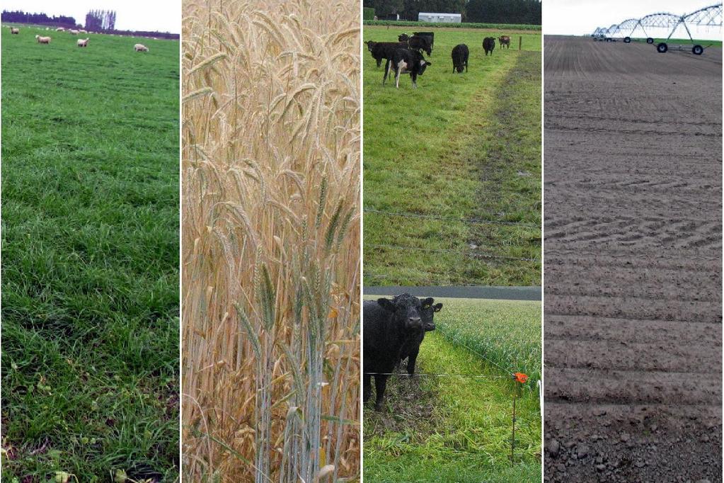
5 Challenge - variety of crops including Barley Borage Carrots Clover Grass Kale Lucerne Oats Onions Peas Potatoes Radish Rapeseed Ryecorn Triticale Turnips Wheat Most of these crops have multiple uses, e.g. Grass pasture, seed Oats grain, winter forage Carrots fresh, seed Kale winter forage, seed


6 Pasture, potatoes,clover and turnips Potatoes, turnips, pasture, clover, and lucerne are not spectrally separable at some stages of their growth cycles


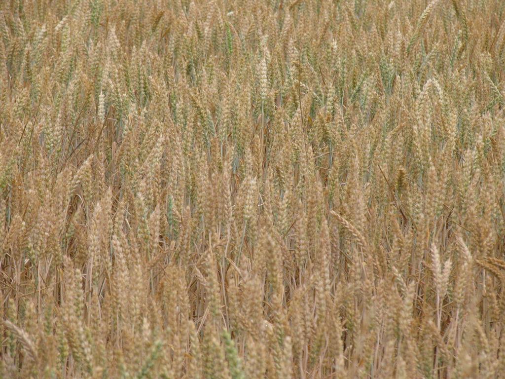
7 Potatoes can look very different at various stages through their growth cycle,
8 Time series of satellite images
9 Time series of satellite images

10 Paddock boundary detection


11 Paddock boundary detection Stack of 3-9 images throughout period of interest Standard deviation enhances boundaries

12 Polygon coverage and cleaning
13
14 Broad land use types for summer classification (16-Dec) - Uses images from 12 months before to 9 months after classification date - Graph shows examples of real paddocks in these classes - Each graph point is extracted from a satellite image at the given date - Expressed as green-ness of paddock (Normalised Difference Vegetation Index)
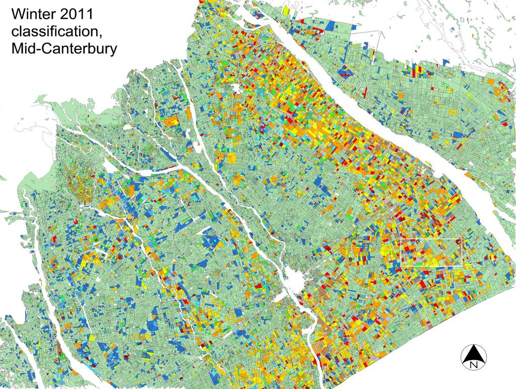
15 Broad land use types for winter classification (16-Jun) - Uses images from 8 months before to 12 months after classification date - Graph shows examples of real paddocks in these classes - Graph points extracted from a time-series satellite images - Expressed as green-ness (NDVI)
16
17
18
19
20
21 Classification steps Identify paddocks Match paddock temporal profiles to model curves Spectral classification at NDVI peak (crop groups)

22 Timing and crop type information produced by summer classification

23 Timing and crop-type information produced by the winter classification
24 Ashburton
25 Accuracy: broad land use level Classified as. Summer Bare Winter Number of BROAD LANDUSE: DEC-10 Pasture Crop Soil Forage paddocks correct 105 Field data Pasture Total number 125 Summer Crop Percent correct 84% Bare Soil Winter Forage ACCURACY FOR THE 3 CLASSIFICATION DATES Dec-10 84% Jun-11 82% Dec-11 92%
26 Accuracy: planting date level Classified as. Early summer (short) Early summer (long) Early PLANTING DATE: DEC-10 autumn Late autumn Winter Spring Number of paddocks correct 34 Field data Early autumn Total number 42 Late autumn Percent correct 81% Winter Spring Early summer (s) Early summer (l) ACCURACY FOR THE 3 CLASSIFICATION DATES Dec-10 81% Jun-11 69% Dec-11 56%
27 Accuracy: mapped crop group Mapped in crop group. Grain (wheat, oats, or Peas or brassica/ radish Brassica (winter livestock Pasture (or Grass seed or Maize White clover Potatoes (or carrot Pasture (lower Unknown crop (lower MAP SYMBOLOGY: DEC-10 lucerne) barley) barley (silage) seed seed seed) forage) probability) probability) Bare soil Field data Wheat Barley Other/unknown grain crop Peas Radish seed Rape seed Other/unknown brassica seed Brassica - winter forage Grass seed Pasture Lucerne Potatoes Maize White clover seed Bare soil Number of paddocks correct 102 MAP SYMBOLOGY: DEC-11 83% Total number 123 FOUR INDIVIDUAL CROPS: JUN-11 81% Percent correct 83%
28 Remaining issues - Difficulty separating grass seed crop from pasture - Irrigated vs dryland pasture accuracy - Further crops and timing classes - Cross-region
 and hilly terrain")
29 Southland winter forage - Winter forage classification only - Simpler set of classes - Challenges: winter images (low sun angles) and hilly terrain
30 More satellites Imagery outlook/trends aimed at different markets, pricing and access models Improved resolution (spatial) Constellations (improved temporal resolution) More/better pre-processing geometric orthorectification calibration higher level image products e.g. cloud masks Global monitoring cheap / free improved spectral resolution
, 30m, 185km swath, 16 day repeat Free online,")

 AVNIR-2; 4 band, 5m, 90km swath HISUI; 57")
31 Landsat 8 (Feb 2013) Examples 11 bands (from 8 on L7), 30m, 185km swath, 16 day repeat Free online, orthorectified Sentinel 2 (Apr 2015) 13 spectral bands, 10m, 290km swath, 5 day repeat two satellite constellation Free online, orthorectified ALOS-3 (2015) AVNIR-2; 4 band, 5m, 90km swath HISUI; 57 band, 30m, 30km swath
32 Computing and workflows High Performance Computing Currently processing all Landsat-8 (339 to date) 1571 Landsat-4,5,7,8 processed to date (4.8 TB) Includes rectification, pan-sharpening, terrain correction, cloud-masking Extend to SPOT, and others as available Timed mosaics based on 4-5 month period Enables temporal analysis
33 Other uses Better classification of crops, land use, practice Improved information for modelling Assist in statistical collection Add value to farmer surveys? In season yield forecasting? Improve land cover mapping (LCDB) Extension to national land-use map?
34 Summary New method to map land use Whole paddocks, regional coverage Temporal profiles from time series of satellite images Provide deep information on land use and farming practice to assess environmental impacts We expect this approach to become increasingly practical New satellites High performance computing
35 Questions?
Classification of Agricultural Crops and Quality Assessment Using Multispectral and Multitemporal Images
 Classification of Agricultural Crops and Quality Assessment Using Multispectral and Multitemporal Images Bo Ranneby and Jun Yu Research Report Centre of Biostochastics Swedish University of Report 2003:7
Arable Land Use in the Gisborne District Summer Crop Survey
 Arable Land Use in the Gisborne District Summer Crop Survey Summer Season 2015/2016 GDC Science Report 4/2016 CONTENTS 1.0 Introduction.2 2.0 Methods...4 3.0 Results...4 3.1 Crop Types 5 3.1.1 Pasture/Unused...5
Overview on Land Cover and Land Use Monitoring in Russia
 Russian Academy of Sciences Space Research Institute Overview on Land Cover and Land Use Monitoring in Russia Sergey Bartalev Joint NASA LCLUC Science Team Meeting and GOFC-GOLD/NERIN, NEESPI Workshop
The use of satellite images to forecast agricultural production
 The use of satellite images to forecast agricultural production Artur Łączyński Central Statistical Office, Agriculture Department Niepodległości 208 Warsaw, Poland E-mail a.laczynski@stat.gov.pl DOI:
EXTRACTION OF REMOTE SENSING INFORMATION OF BANANA UNDER SUPPORT OF 3S TECHNOLOGY IN GUANGXI PROVINCE
 EXTRACTION OF REMOTE SENSING INFORMATION OF BANANA UNDER SUPPORT OF 3S TECHNOLOGY IN GUANGXI PROVINCE Xin Yang 1,2,*, Han Sun 1, 2, Zongkun Tan 1, 2, Meihua Ding 1, 2 1 Remote Sensing Application and Test
REMOTELY SENSED INFORMATION FOR CROP MONITORING AND FOOD SECURITY
 LEARNING OBJECTIVES Lesson 4 Methods and Analysis 2: Rainfall and NDVI Seasonal Graphs At the end of the lesson, you will be able to: understand seasonal graphs for rainfall and NDVI; describe the concept
Mapping Salinity in the Loddon and Campaspe Catchments. in Victoria
 Mapping Salinity in the Loddon and Campaspe Catchments in Victoria A report from the LWWRDC project Mapping Dryland Salinity (CDM2) S. Furby CSIRO Mathematical and Information Sciences CMIS 98/115 2 Summary
DROUGHT ASSESSMENT USING SATELLITE DERIVED METEOROLOGICAL PARAMETERS AND NDVI IN POTOHAR REGION
 DROUGHT ASSESSMENT USING SATELLITE DERIVED METEOROLOGICAL PARAMETERS AND NDVI IN POTOHAR REGION Researcher: Saad-ul-Haque Supervisor: Dr. Badar Ghauri Department of RS & GISc Institute of Space Technology
Leveraging Sentinel-1 time-series data for mapping agricultural land cover and land use in the tropics
 Leveraging Sentinel-1 time-series data for mapping agricultural land cover and land use in the tropics Caitlin Kontgis caitlin@descarteslabs.com @caitlinkontgis Descartes Labs Overview What is Descartes
USING LANDSAT IN A GIS WORLD
 USING LANDSAT IN A GIS WORLD RACHEL MK HEADLEY; PHD, PMP STEM LIAISON, ACADEMIC AFFAIRS BLACK HILLS STATE UNIVERSITY This material is based upon work supported by the National Science Foundation under
EFFECT OF ANCILLARY DATA ON THE PERFORMANCE OF LAND COVER CLASSIFICATION USING A NEURAL NETWORK MODEL. Duong Dang KHOI.
 EFFECT OF ANCILLARY DATA ON THE PERFORMANCE OF LAND COVER CLASSIFICATION USING A NEURAL NETWORK MODEL Duong Dang KHOI 1 10 Feb, 2011 Presentation contents 1. Introduction 2. Methods 3. Results 4. Discussion
Monitoring Vegetation Growth of Spectrally Landsat Satellite Imagery ETM+ 7 & TM 5 for Western Region of Iraq by Using Remote Sensing Techniques.
 Monitoring Vegetation Growth of Spectrally Landsat Satellite Imagery ETM+ 7 & TM 5 for Western Region of Iraq by Using Remote Sensing Techniques. Fouad K. Mashee, Ahmed A. Zaeen & Gheidaa S. Hadi Remote
Application of EO for Environmental Monitoring at the Finnish Environment Institute
 Application of EO for Environmental Monitoring at the Finnish Environment Institute Data Processing (CalFin) and Examples of Products Markus Törmä Finnish Environment Institute SYKE markus.torma@ymparisto.fi
Background and Assumptions
 2017 Costs and Returns Estimate Eastern Idaho: Lower Rainfall Dryland Feed Barley Ben Eborn and Terrell Sorensen Eastern Idaho Background and Assumptions The University of Idaho s costs and returns estimates
Budgets: 2007 planning budgets
 R5 Ranch Budgets: 2007 planning budgets Anywhere UR, Eastern Oregon File: Ray & Reba Barlow User: Bart Eleveld FINPACK Printed 10/30/2008 3:33:50 PM Crop Budget No. 1 2 3 Crop Wheat, Cash Winter Barley,
Relative soil vulnerability and patterns of erosion during the muddy floods of on the South Downs, Sussex, UK
 Relative soil vulnerability and patterns of erosion during the muddy floods of 2000-2001 on the South Downs, Sussex, UK Hazel Faulkner, Jose Luis Ruiz & John Boardman South Downs East Sussex Due to a long
Project title. Evaluation of MIR data from SPOT4/VEGETATION for the monitoring of climatic phenomena impact on vegetation
 Project title 1 Evaluation of MIR data from SPOT4/VEGETATION for the monitoring of climatic phenomena impact on vegetation Principal investigator: M-Christine IMBERTI Co-investigator: Frédéric BIARD Stockholm
Head office Lahti, Finland
 Malting Barley Report June 5, 2012 Sweden Drilling is finally completed in all parts of Sweden. Drilling started earlier than normal in the south, west and east part of Sweden and a god part of the malting
Rating of soil heterogeneity using by satellite images
 Rating of soil heterogeneity using by satellite images JAROSLAV NOVAK, VOJTECH LUKAS, JAN KREN Department of Agrosystems and Bioclimatology Mendel University in Brno Zemedelska 1, 613 00 Brno CZECH REPUBLIC
Abstract. TECHNOFAME- A Journal of Multidisciplinary Advance Research. Vol.2 No. 2, (2013) Received: Feb.2013; Accepted Oct.
 Received: Feb.2013; Accepted Oct.") Vol.2 No. 2, 83-87 (2013) Received: Feb.2013; Accepted Oct. 2013 Landuse Pattern Analysis Using Remote Sensing: A Case Study of Morar Block, of Gwalior District, M.P. Subhash Thakur 1 Akhilesh Singh 2
Vol.2 No. 2, 83-87 (2013) Received: Feb.2013; Accepted Oct. 2013 Landuse Pattern Analysis Using Remote Sensing: A Case Study of Morar Block, of Gwalior District, M.P. Subhash Thakur 1 Akhilesh Singh 2
Weather and climate outlooks for crop estimates
 Weather and climate outlooks for crop estimates CELC meeting 2016-04-21 ARC ISCW Observed weather data Modeled weather data Short-range forecasts Seasonal forecasts Climate change scenario data Introduction
C N E S, U M R I R I S A
 M O N I T O R I N G U R B A N A R E A S W I T H S E N T I N E L - 2. APPLICATION TO THE UPDATE OF THE COPERNICUS HIGH RESOLUTION LAYER IMPERVIOUSNESS DEGREE O c t o b e r 2 5 th 2016, Brussels A n t o
An experimental study of angular variations of brightness surface temperature for some natural surfaces
 An experimental study of angular variations of brightness surface temperature for some natural surfaces Juan Cuenca, José A. Sobrino, and Guillem Soria University of Valencia, c./ Dr. Moliner 5, 46 Burjassot,
DROUGHT RISK EVALUATION USING REMOTE SENSING AND GIS : A CASE STUDY IN LOP BURI PROVINCE
 DROUGHT RISK EVALUATION USING REMOTE SENSING AND GIS : A CASE STUDY IN LOP BURI PROVINCE K. Prathumchai, Kiyoshi Honda, Kaew Nualchawee Asian Centre for Research on Remote Sensing STAR Program, Asian Institute
REMOTELY SENSED INFORMATION FOR CROP MONITORING AND FOOD SECURITY
 LEARNING OBJECTIVES Lesson 4 Methods and Analysis 2: Rainfall and NDVI Seasonal Graphs At the end of the lesson, you will be able to: understand seasonal graphs for rainfall and NDVI; describe the concept
High resolution wetland mapping I.
 High resolution wetland mapping I. Based on the teaching material developed by Steve Kas, GeoVille for WOIS Product Group #5 Dr. Zoltán Vekerdy and János Grósz z.vekerdy@utwente.nl vekerdy.zoltan@mkk.szie.hu
SUPPORTING INFORMATION. Ecological restoration and its effects on the
 SUPPORTING INFORMATION Ecological restoration and its effects on the regional climate: the case in the source region of the Yellow River, China Zhouyuan Li, Xuehua Liu,* Tianlin Niu, De Kejia, Qingping
Effective Utilization of Synthetic Aperture Radar (SAR) Imagery in Rapid Damage Assessment
 Imagery in Rapid Damage Assessment") Effective Utilization of Synthetic Aperture Radar (SAR) Imagery in Rapid Damage Assessment Case Study Pakistan Floods SUPARCO M. Maisam Raza, Ahmad H. Rabbani SEQUENCE Flood Monitoring using Satellite
Effective Utilization of Synthetic Aperture Radar (SAR) Imagery in Rapid Damage Assessment Case Study Pakistan Floods SUPARCO M. Maisam Raza, Ahmad H. Rabbani SEQUENCE Flood Monitoring using Satellite
FEBRUARY 15-29, 2016 NATURAL HISTORY NOTES FOR EASTVIEW By Dick Harlow GARDENING BY THE LUNAR CYCLE
 HAPPY LEAP YEAR Every four years in the Gregorian calendar, an extra day is added to the calendar in order to synchronize it with the solar year. And, by Irish tradition if you are a woman and ask a man
2016 International Conference on Modern Economic Development and Environment Protection (ICMED 2016) ISBN:
 ISBN:") 2016 International Conference on Modern Economic Development and Environment Protection (ICMED 2016) ISBN: 978-1-60595-355-7 Difference in FVC Changes between Desert Grasslands with Different Stocking
2016 International Conference on Modern Economic Development and Environment Protection (ICMED 2016) ISBN: 978-1-60595-355-7 Difference in FVC Changes between Desert Grasslands with Different Stocking
Data Fusion and Multi-Resolution Data
 Data Fusion and Multi-Resolution Data Nature.com www.museevirtuel-virtualmuseum.ca www.srs.fs.usda.gov Meredith Gartner 3/7/14 Data fusion and multi-resolution data Dark and Bram MAUP and raster data Hilker
Urban remote sensing: from local to global and back
 Urban remote sensing: from local to global and back Paolo Gamba University of Pavia, Italy A few words about Pavia Historical University (1361) in a nice town slide 3 Geoscience and Remote Sensing Society
WHEN CAN YOU SEED FALLOW GROUND IN THE FALL? AN HISTORICAL PERSPECTIVE ON FALL RAIN
 WHEN CAN YOU SEED FALLOW GROUND IN THE FALL? AN HISTORICAL PERSPECTIVE ON FALL RAIN Steve Petrie and Karl Rhinhart Abstract Seeding at the optimum time is one key to producing the greatest yield of any
The Climate of Oregon Climate Zone 7 South Central Area
 /65 '5 Unbound issue tqc;. 9 11 Does not circulate (i.13 Special Report 919 May The Climate of Oregon Climate Zone 7 Property of OREGON STATE UNIVERSITY Library Serials Corvallis, OR 9 733 1-4503 Agricultural
Microwave emissivity of land surfaces: experiments and models
 Microwave emissivity of land surfaces: experiments and models M. Brogioni, G.Macelloni, S.Paloscia, P.Pampaloni, S.Pettinato, E.Santi IFAC-CNR Florence, Italy Introduction Experimental investigations conducted
Landcover Dynamics in the Niger Inland Delta (Mali)
") Fakultät Forst-, Geo- Hydrowissenschaften Institut f. Photogrammetrie & Fernerkundung, Professur Fernerkundung Landcover Dynamics in the Niger Inland Delta (Mali) A Classification Approach for MERIS Data
Fakultät Forst-, Geo- Hydrowissenschaften Institut f. Photogrammetrie & Fernerkundung, Professur Fernerkundung Landcover Dynamics in the Niger Inland Delta (Mali) A Classification Approach for MERIS Data
Many of remote sensing techniques are generic in nature and may be applied to a variety of vegetated landscapes, including
 Remote Sensing of Vegetation Many of remote sensing techniques are generic in nature and may be applied to a variety of vegetated landscapes, including 1. Agriculture 2. Forest 3. Rangeland 4. Wetland,
COMPARISON OF PIXEL-BASED AND OBJECT-BASED CLASSIFICATION METHODS FOR SEPARATION OF CROP PATTERNS
 COMPARISON OF PIXEL-BASED AND OBJECT-BASED CLASSIFICATION METHODS FOR SEPARATION OF CROP PATTERNS Levent BAŞAYİĞİT, Rabia ERSAN Suleyman Demirel University, Agriculture Faculty, Soil Science and Plant
Land cover/land use mapping and cha Mongolian plateau using remote sens. Title. Author(s) Bagan, Hasi; Yamagata, Yoshiki. Citation Japan.
 Bagan, Hasi; Yamagata, Yoshiki. Citation Japan.") Title Land cover/land use mapping and cha Mongolian plateau using remote sens Author(s) Bagan, Hasi; Yamagata, Yoshiki International Symposium on "The Imp Citation Region Specific Systems". 6 Nove Japan.
Title Land cover/land use mapping and cha Mongolian plateau using remote sens Author(s) Bagan, Hasi; Yamagata, Yoshiki International Symposium on "The Imp Citation Region Specific Systems". 6 Nove Japan.
Mapping Soils, Crops, and Rangelands by Machine Analysis of Multi-Temporal ERTS-1 Data
 Purdue University Purdue e-pubs LARS Technical Reports Laboratory for Applications of Remote Sensing 1-1-1973 Mapping Soils, Crops, and Rangelands by Machine Analysis of Multi-Temporal ERTS-1 Data M. F.
IDENTIFICATION OF LAND-USE AND VEGETATION TYPES IN FATEH JANG AREA, USING LANDSAT-TM DATA
 IDENTIFICATION OF LAND-USE AND VEGETATION TYPES IN FATEH JANG AREA, USING LANDSAT-TM DATA Rakshan Roohi* Arshad Ashraf** and Shahid Ahmad*** ABSTRACT The study area has an undulating topography, with terraced
Crop and pasture monitoring in Eritrea
 JRC SCIENTIFIC AND POLICY REPORTS Crop and pasture monitoring in Eritrea Kremti rainy season started with substantial delay Ana Pérez-Hoyos, Francois Kayitakire, Hervé Kerdiles, Felix Rembold, Olivier
Use of SAR data for Rice Assessment
 Use of SAR data for Rice Assessment N e e t u, S h i b e n d u S R a y a n d T e a m M a h a l a n o b i s N a t i o n a l C r o p F o r e c a s t C e n t r e, D e p a r t m e n t o f A g r i c u l t u
SATELLITE REMOTE SENSING
 SATELLITE REMOTE SENSING of NATURAL RESOURCES David L. Verbyla LEWIS PUBLISHERS Boca Raton New York London Tokyo Contents CHAPTER 1. SATELLITE IMAGES 1 Raster Image Data 2 Remote Sensing Detectors 2 Analog
METRIC tm. Mapping Evapotranspiration at high Resolution with Internalized Calibration. Shifa Dinesh
 METRIC tm Mapping Evapotranspiration at high Resolution with Internalized Calibration Shifa Dinesh Outline Introduction Background of METRIC tm Surface Energy Balance Image Processing Estimation of Energy
N Management in Potato Production. David Mulla, Carl Rosen, Tyler Nigonand Brian Bohman Dept. Soil, Water & Climate University of Minnesota
 N Management in Potato Production David Mulla, Carl Rosen, Tyler Nigonand Brian Bohman Dept. Soil, Water & Climate University of Minnesota Topics Background and conventional nitrogen management Evaluate
Monthly overview. Rainfall
 Monthly overview 1 to 10 April 2018 Widespread rainfall continued to fall over most parts of the summer rainfall region during this period. Unseasonably good rain fell over the eastern half of the Northern
EMVEST ASSET MANAGEMENT PTY LIMITED. Investment Proposal. Matuba Estate Chokwe District Mozambique
 EMVEST ASSET MANAGEMENT PTY LIMITED Investment Proposal Matuba Estate Chokwe District Mozambique 20 July 2009 PROJECT SUMMARY Project Name: EMVEST LIMOPO Lda (MATUBA), District Chokwe, Province of Gaza.
Investigation of Relationship Between Rainfall and Vegetation Index by Using NOAA/AVHRR Satellite Images
 World Applied Sciences Journal 14 (11): 1678-1682, 2011 ISSN 1818-4952 IDOSI Publications, 2011 Investigation of Relationship Between Rainfall and Vegetation Index by Using NOAA/AVHRR Satellite Images
A Cotton Irrigator s Decision Support System Using National, Regional and Local Data
 A Cotton Irrigator s Decision Support System Using National, Regional and Local Data ISESS 2015, Melbourne Jamie Vleeshouwer, Nicholas J. Car, John Hornbuckle 26 March 2015 LAND & WATER FLAGSHIP / AGRICULTURE
Estimation of Wavelet Based Spatially Enhanced Evapotranspiration Using Energy Balance Approach
 Estimation of Wavelet Based Spatially Enhanced Evapotranspiration Using Energy Balance Approach Dr.Gowri 1 Dr.Thirumalaivasan 2 1 Associate Professor, Jerusalem College of Engineering, Department of Civil
Rice Monitoring using Simulated Compact SAR. Kun Li, Yun Shao Institute of Remote Sensing and Digital Earth
 Rice Monitoring using Simulated Compact SAR Kun Li, Yun Shao Institute of Remote Sensing and Digital Earth Outlines Introduction Test site and data Results Rice type discrimination Rice phenology retrieval
The Effect of the No-Burn Ban on the Economic Viability of Producing Bluegrass Seed in Select Areas of Washington State
 Farm Business Management Reports EB1922E The Effect of the No-Burn Ban on the Economic Viability of Producing Bluegrass Seed in Select Areas of Washington State Herbert R. Hinman Alan Schreiber Online
A NORMALIZED DIFFERENCE VEGETATION INDEX (NDVI) TIME-SERIES OF IDLE AGRICULTURE LANDS: A PRELIMINARY STUDY
 TIME-SERIES OF IDLE AGRICULTURE LANDS: A PRELIMINARY STUDY") A NORMALIZED DIFFERENCE VEGETATION INDEX (NDVI) TIME-SERIES OF IDLE AGRICULTURE LANDS: A PRELIMINARY STUDY Chaichoke Vaiphasa 1*, Supawee Piamduaytham 2, Tanasak Vaiphasa 3, and Andrew K. Skidmore 4 1
A NORMALIZED DIFFERENCE VEGETATION INDEX (NDVI) TIME-SERIES OF IDLE AGRICULTURE LANDS: A PRELIMINARY STUDY Chaichoke Vaiphasa 1*, Supawee Piamduaytham 2, Tanasak Vaiphasa 3, and Andrew K. Skidmore 4 1
An Automated Object-Oriented Satellite Image Classification Method Integrating the FAO Land Cover Classification System (LCCS).
.") An Automated Object-Oriented Satellite Image Classification Method Integrating the FAO Land Cover Classification System (LCCS). Ruvimbo Gamanya Sibanda Prof. Dr. Philippe De Maeyer Prof. Dr. Morgan De
An Automated Object-Oriented Satellite Image Classification Method Integrating the FAO Land Cover Classification System (LCCS). Ruvimbo Gamanya Sibanda Prof. Dr. Philippe De Maeyer Prof. Dr. Morgan De
Remote Sensing Based Inversion of Gap Fraction for Determination of Leaf Area Index. Alemu Gonsamo 1 and Petri Pellikka 1
 Remote Sensing Based Inversion of Gap Fraction for Determination of Leaf Area Index Alemu Gonsamo and Petri Pellikka Department of Geography, University of Helsinki, P.O. Box, FIN- Helsinki, Finland; +-()--;
LAND USE MAPPING AND MONITORING IN THE NETHERLANDS (LGN5)
") LAND USE MAPPING AND MONITORING IN THE NETHERLANDS (LGN5) Hazeu, Gerard W. Wageningen University and Research Centre - Alterra, Centre for Geo-Information, The Netherlands; gerard.hazeu@wur.nl ABSTRACT
LAND USE MAPPING AND MONITORING IN THE NETHERLANDS (LGN5) Hazeu, Gerard W. Wageningen University and Research Centre - Alterra, Centre for Geo-Information, The Netherlands; gerard.hazeu@wur.nl ABSTRACT
Lecture Topics. 1. Vegetation Indices 2. Global NDVI data sets 3. Analysis of temporal NDVI trends
 Lecture Topics 1. Vegetation Indices 2. Global NDVI data sets 3. Analysis of temporal NDVI trends Why use NDVI? Normalize external effects of sun angle, viewing angle, and atmospheric effects Normalize
Northwest Outlook September 2017
 Northwest Outlook September 2017 Hot and dry August August 2017 continued with the pattern established in June and July that featured a large, semipermanent ridge in the flow of the jet stream. Temperatures
CATCHMENT DESCRIPTION. Little River Catchment Management Plan Stage I Report Climate 4.0
 CATCHMENT DESCRIPTION Little River Catchment Management Plan Stage I Report Climate 4. Little River Catchment Management Plan Stage I Report Climate 4.1 4. CLIMATE 4.1 INTRODUCTION Climate is one of the
(i) Complete the diagram below to show the fates of carbon dioxide after photosynthesis has taken place.
 Complete the diagram below to show the fates of carbon dioxide after photosynthesis has taken place.") 3. (a) Carbon dioxide is used during photosynthesis to produce sugar. (i) Complete the diagram below to show the fates of carbon dioxide after photosynthesis has taken place. stored as starch carbon dioxide
3. (a) Carbon dioxide is used during photosynthesis to produce sugar. (i) Complete the diagram below to show the fates of carbon dioxide after photosynthesis has taken place. stored as starch carbon dioxide
REMOTE SENSING ACTIVITIES. Caiti Steele
 REMOTE SENSING ACTIVITIES Caiti Steele REMOTE SENSING ACTIVITIES Remote sensing of biomass: Field Validation of Biomass Retrieved from Landsat for Rangeland Assessment and Monitoring (Browning et al.,
A decision support system for predicting seasonal rainfall variations in sub-humid and semi-arid high country areas
 Proceedings of the New Zealand Grassland Association 58: 87 91 (1996) 87 A decision support system for predicting seasonal rainfall variations in sub-humid and semi-arid high country areas G.K. HUTCHINSON
Soil Erosion Calculation using Remote Sensing and GIS in Río Grande de Arecibo Watershed, Puerto Rico
 Soil Erosion Calculation using Remote Sensing and GIS in Río Grande de Arecibo Watershed, Puerto Rico Alejandra M. Rojas González Department of Civil Engineering University of Puerto Rico at Mayaguez.
ANALYSIS AND VALIDATION OF A METHODOLOGY TO EVALUATE LAND COVER CHANGE IN THE MEDITERRANEAN BASIN USING MULTITEMPORAL MODIS DATA
 PRESENT ENVIRONMENT AND SUSTAINABLE DEVELOPMENT, NR. 4, 2010 ANALYSIS AND VALIDATION OF A METHODOLOGY TO EVALUATE LAND COVER CHANGE IN THE MEDITERRANEAN BASIN USING MULTITEMPORAL MODIS DATA Mara Pilloni
The Colorado Drought of 2002 in Perspective
 The Colorado Drought of 2002 in Perspective Colorado Climate Center Nolan Doesken and Roger Pielke, Sr. Prepared by Tara Green and Odie Bliss http://climate.atmos.colostate.edu Known Characteristics of
Land cover research, applications and development needs in Slovakia
 Land cover research, applications and development needs in Slovakia Andrej Halabuk Institute of Landscape Ecology Slovak Academy of Sciences (ILE SAS) Štefánikova 3, 814 99 Bratislava, Slovakia Institute
Background and Assumptions
 2017 Costs and Returns Estimate Southcentral Idaho: Magic Valley Alfalfa Hay Establishment with Oats Ben Eborn Magic Valley Background and Assumptions The University of Idaho s costs and returns estimates
MAXMISING AUTOMATION IN LAND COVER MONITORING WITH CHANGE DETECTION. 1. Remote Sensing Research Unit, CSIR-Meraka, Pretoria, 0001, South Africa
 MAXMISING AUTOMATION IN LAND COVER MONITORING WITH CHANGE DETECTION Konrad Wessels 1, Frans van den Bergh 1, Karen Steenkamp 1, Derick Swanepoel 1, Bryan McAlister 1, Brian Salmon 1, David Roy 2 and Valeriy
GIS AND REMOTE SENSING FOR WATER RESOURCE MANAGEMENT
 GIS AND REMOTE SENSING FOR WATER RESOURCE MANAGEMENT G. GHIANNI, G. ADDEO, P. TANO CO.T.IR. Extension and experimental station for irrigation technique - Vasto (Ch) Italy. E-mail : ghianni@cotir.it, addeo@cotir.it,
Terrestrial pyrogenic carbon export to fluvial ecosystems: lessons learned from the White Nile watershed of East Africa
 Global Biogeochemical Cycles Supporting Information for Terrestrial pyrogenic carbon export to fluvial ecosystems: lessons learned from the White ile watershed of East Africa David T. Güereña, Johannes
Earth Observation Satellites Dawn of Application Specific Satellite Data. Date: 26 July 2017
 Earth Observation Satellites Dawn of Application Specific Satellite Data Date: 26 July 2017 Introducing a World of New Possibilities Satellite imagery is a critical fountain of information on al levels
Using LST and SSE from Hyperspectral Thermal Infrared Airborne Data for Satellite Validation: Application to AisaOWL
 Using LST and SSE from Hyperspectral Thermal Infrared Airborne Data for Satellite Validation: Application to AisaOWL Mary Langsdale, Martin Wooster, Bruce Main, Daniel Fisher, Weidong Xu and Maniseng Sarrazy-Weston
Paul Patterson, Steven Hines and Juliet Marshall. Background and Assumptions
 2015 Costs and Returns Estimate Southcentral Idaho: Magic Valley Spring Malting Barley Paul Patterson, Steven Hines and Juliet Marshall. Background and Assumptions Magic Valley The University of Idaho
IMPROVING REMOTE SENSING-DERIVED LAND USE/LAND COVER CLASSIFICATION WITH THE AID OF SPATIAL INFORMATION
 IMPROVING REMOTE SENSING-DERIVED LAND USE/LAND COVER CLASSIFICATION WITH THE AID OF SPATIAL INFORMATION Yingchun Zhou1, Sunil Narumalani1, Dennis E. Jelinski2 Department of Geography, University of Nebraska,
AAFC Annual Crop Inventory
 AAFC Annual Crop Inventory Status and Challenges Fisette, T., Rollin, P., Aly, Z., Campbell, L., Daneshfar, B., Filyer, P., Smith, A., Davidson, A., Shang, J., Jarvis, I. Agriculture and Agri-Food Canada
Monthly Overview. Rainfall
 Monthly Overview Rainfall during August occurred mainly over the Western and Eastern Cape provinces, and KwaZulu- Natal. Rain in these provinces were regularly accompanied by cold fronts as they made landfall
Midwest and Great Plains Drought and Climate Summary 20 February 2014
 Midwest and Great Plains Drought and Climate Summary 20 February 2014 Wendy Ryan Assistant State Climatologist Colorado Climate Center Colorado State University wendy.ryan@colostate.edu 970-491-8506 General
Time Series Analysis with SAR & Optical Satellite Data
 Time Series Analysis with SAR & Optical Satellite Data Thomas Bahr ESRI European User Conference Thursday October 2015 harris.com Motivation Changes in land surface characteristics mirror a multitude of
2005 KANSAS LAND COVER PATTERNS PHASE I - FINAL REPORT
 2005 KANSAS LAND COVER PATTERNS PHASE I - FINAL REPORT KBS Report # 150 Kansas Applied Remote Sensing Program Kansas Biological Survey University of Kansas Lawrence, Kansas 66047 July 2008 Report Prepared
Object Oriented Classification Using High-Resolution Satellite Images for HNV Farmland Identification. Shafique Matin and Stuart Green
 Object Oriented Classification Using High-Resolution Satellite Images for HNV Farmland Identification Shafique Matin and Stuart Green REDP, Teagasc Ashtown, Dublin, Ireland Correspondence: shafique.matin@teagasc.ie
Land abandonment and recultivation in Central and Eastern Europe
 Land abandonment and recultivation in Central and Eastern Europe Patrick Hostert Patrick Griffiths, Stephan Estel, Camilo Alcantara, Tobias Kuemmerle, Dirk Pflugmacher, Alexander Prishchepov, Volker Radeloff
Historical land cover assessment: challenges and achievements
 Historical land cover assessment: challenges and achievements K. Sheffield 1, E. Morse-McNabb 2 1 Future Farming Systems Research Division, Department of Primary Industries, Parkville, kathryn.sheffield@dpi.vic.gov.au
CAPE FARM MAPPER - an integrated spatial portal
 CAPE FARM MAPPER - an integrated spatial portal Skukuza Dr Mike Wallace June 2017 Overview of GIS applications in WCDoA Spatial information and technology has become indispensable across a wide range of
Comparison between Multitemporal and Polarimetric SAR Data for Land Cover Classification
 Downloaded from orbit.dtu.dk on: Sep 19, 2018 Comparison between Multitemporal and Polarimetric SAR Data for Land Cover Classification Skriver, Henning Published in: Geoscience and Remote Sensing Symposium,
NATIONAL MAPPING EFFORTS: THE PHILIPPINES
 NATIONAL MAPPING EFFORTS: THE PHILIPPINES Dr. RIJALDIA N. SANTOS DENR National Mapping and Resource Information Authority (NAMRIA) May 30, 2018 Land Cover/Land Use Changes (LC/LUC) and Its Impacts on Environment
Partial budgets for cover crops in Midwest row crop farming
 Partial budgets for cover crops in Midwest row crop farming A. Plastina, F. Liu, W. Sawadgo, F. Miguez, and S. Carlson. Conservation Infrastructure (CI) - Cover Crops Working Group Iowa Farm Bureau Federation
Remote Sensing of Snow GEOG 454 / 654
 Remote Sensing of Snow GEOG 454 / 654 What crysopheric questions can RS help to answer? 2 o Where is snow lying? (Snow-covered area or extent) o How much is there? o How rapidly is it melting? (Area, depth,
LAND COVER CLASSIFICATION BASED ON SAR DATA IN SOUTHEAST CHINA
 LAND COVER CLASSIFICATION BASED ON SAR DATA IN SOUTHEAST CHINA Mr. Feilong Ling, Dr. Xiaoqin Wang, Mr.Xiaoming Shi Fuzhou University, Level 13, Science Building,No.53 Gongye Rd., 35, Fuzhou, China Email:
Communicating Climate Change Consequences for Land Use
 Communicating Climate Change Consequences for Land Use Site: Prabost, Skye. Event: Kyle of Lochalsh, 28 th February 28 Further information: http://www.macaulay.ac.uk/ladss/comm_cc_consequences.html Who
LAND USE MAPPING FOR CONSTRUCTION SITES
 LAND USE MAPPING FOR CONSTRUCTION SITES STATEMENT OF THE PROBLEM Monitoring of existing construction sites within the limits of the City of Columbia is a requirement of the city government for: 1) Control
Analyzing spatial and temporal variation of water balance components in La Vi catchment, Binh Dinh province, Vietnam
 Analyzing spatial and temporal variation of water balance components in La Vi catchment, Binh Dinh province, Vietnam Nguyen Duy Liem, Vo Ngoc Quynh Tram, Nguyen Le Tan Dat, Nguyen Kim Loi Nong Lam University-
The Climate of Oregon Climate Zone 5 High Plateau
 105 E55 Unbound issue i". 9 13oes not circulate CZe Special Report 917 May 1993 The Climate of Oregon Climate Zone 5 Property of OREGON STATE UNIVERSITY Library Serials Corvallis, OR 97331-4503 Agricultural
Advanced Image Analysis in Disaster Response
 Advanced Image Analysis in Disaster Response Creating Geographic Knowledge Thomas Harris ITT The information contained in this document pertains to software products and services that are subject to the
Oregon Certification Activity Summary 2008
 Oregon Seed Certification Service Tel: (541) 737-4513 Department of Crop and Soil Science Fax: (541) 737-2624 31 Crop Science Bldg seed-cert@oscs.oregonstate.edu Corvallis, Oregon 97331 www.oscs.oregonstate.edu
Economics and Competitiveness. Cost and Return Benchmarks for Crops and Forages. Brown Soil Zone
 Economics and Competitiveness 2015 Cost and Return Benchmarks for Crops and Forages Brown Soil Zone TABLE OF CONTENTS 2015 Brown Soil Zone OVERVIEW...1 CROPS Spring Wheat...2 FORAGES Roundup Ready Canola...5
Flower Species as a Supplemental Source of Pollen for Honey Bees (Apis mellifera) in Late Summer Cropping Systems
 in Late Summer Cropping Systems") Flower Species as a Supplemental Source of Pollen for Honey Bees (Apis mellifera) in Late Summer Cropping Systems Rhonda Simmons, Ramesh Sagili, and Bruce Martens Abstract Honey bee forager preference
Flower Species as a Supplemental Source of Pollen for Honey Bees (Apis mellifera) in Late Summer Cropping Systems Rhonda Simmons, Ramesh Sagili, and Bruce Martens Abstract Honey bee forager preference
Monitoring daily evapotranspiration in the Alps exploiting Sentinel-2 and meteorological data
 Monitoring daily evapotranspiration in the Alps exploiting Sentinel-2 and meteorological data M. Castelli, S. Asam, A. Jacob, M. Zebisch, and C. Notarnicola Institute for Earth Observation, Eurac Research,
El Nino: Outlook VAM-WFP HQ September 2018
 El Nino: Outlook 2018 VAM-WFP HQ September 2018 El Nino Outlook September 2018 2015-16 El Nino Peak Possible evolution of an El Nino indicator (Pacific sea surface temperature anomaly) generated by a diverse
Variability of Reference Evapotranspiration Across Nebraska
 Know how. Know now. EC733 Variability of Reference Evapotranspiration Across Nebraska Suat Irmak, Extension Soil and Water Resources and Irrigation Specialist Kari E. Skaggs, Research Associate, Biological