Rice Monitoring using Simulated Compact SAR. Kun Li, Yun Shao Institute of Remote Sensing and Digital Earth
|
|
|
- Jayson Campbell
- 6 years ago
- Views:
Transcription

1 Rice Monitoring using Simulated Compact SAR Kun Li, Yun Shao Institute of Remote Sensing and Digital Earth
2 Outlines Introduction Test site and data Results Rice type discrimination Rice phenology retrieval Conclusion Future work
3 Introduction Rice is the staple food of about half population of the world. Rice monitoring is very important. Previous works mostly concentrated on rice identification and yield estimation. Full-pol SAR is an effective tool for rice monitoring. Compact polarimetric (CP) SAR provides wider swath than full-pol SAR, while it includes similar information. Rice variety classification is very important for yield estimation. Phenology can help farmers know the current situation of rice and plan cultivation practices.
4 Objectives To explore the potentiality of Compact SAR data in rice variety discrimination and rice phenology retrieval, then to guide farming activites and management of domestic supplies and market value for farm managers.

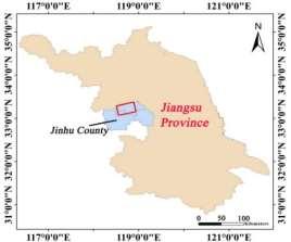
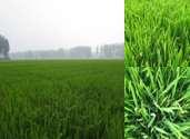
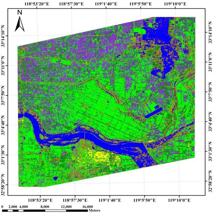
5 Test site and data


")

")
")
")
")


6 Rice morphology (a) Seedling stage (b) Tillering stage (c) Elongation stage (d) Heading stage (e) Flowering stage (f) Milk stage (g) Dough stage (h) Follow Hybrid rice (i) Seedling stage (j) Tillering stage (k) Elongation stage (l) Heading stage (m) Flowering stage (n) Milk stage (o) Dough stage (p) Mature stage Japonica rice
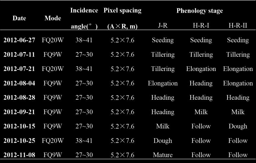
7 SAR data

8 Compact SAR parameters
9 Results Rice variety discrimination The 1 st Step The 2 nd Step Rice fine-classification in whole growth season; Rice classification in early growth season (before heading stage); Retrieval of rice phenology
10 Rice fine-classification in whole season Methodology Rice identification; Hybrid and japonica rice discrimination;
 Jul. 11 (b) Oct.")

11 Rice identification The 1 st Step The 2 nd Step (a) Jul. 11 (b) Oct. 15 Backscatter coefficients of rice and non-rice in compact mode
12 Overall accuracy: 96.72%

13 Hybrid and japonica rice identification RH RV RR RL
14 Algorithm of rice fine-classification Water, C-P (Crab Pond), B-L (Bare Land), Forest and Urban can be classified by importing Compact SAR parameters on Aug. 04, Sep. 21 and Oct. 25, based on rice variety identification. 9 Temporal Simulated CP Data 1025_RV -20 db 0804_RR db and 0721_RH db 1025_RH db and 0711_RR db 1015_RH db and 1108_RV db B-L 0921_RV db Water _RR db Urban C-P Water _RL-1108_RL db Forest J-R H-R
15
16 Rice fine-classification in whole season Class Water C-P B-L Urban Forest H-R J-R Total The 1 st Step The 2 nd Step User Acc. (%) Water C-P B-L Urban Forest H-R J-R Total Prod Acc. (%) Overall Acc. = 21085/22758 = 92.65%, Kappa Coefficient = 0.91
17 Rice classification in early of season Early rice monitoring are important to facilitate food price stability for regions at risk, and for agriculture exporters, to set The 1 st Step market price. The 2 nd Step The temporal Compact SAR parameters on June 27 (seedling), July 11 (early of tillering), July 21 (tillering) and August 4 (elongation) are analyzed. (4 temporal before heading stage) Through analysis of parameters, rice and non-rice can be classified firstly, then June 27 (seedling) is the optimal for classifying hybrid and japonica rice in early of season.
 can be used to classify the rice and")
18 Rice identification (a) m-chi-db (b) m-chi-v (a) and (b) can be used to classify the rice and non-rice.


19 Hybrid and japonica rice identification The 1 st Step The 2 nd Step The parameter of m-chi-s or RL in June 27 (seedling) is the optimal for classifying hybrid and japonica in early of season.
20 Rice classification in early of season The Early Four Temporal Simulated CP Data 0721_Dihedral -30 db and 0804_Dihedral -26 db The 1 st Step 0721_Volume -18 db The 2 nd Step Water 0804_Dihedral -22 db C-P 0627_Dihedral -14 db B-L 0627_Volume -12 db Urban 0627_Surface -14 db Forest J-R H-R
21
22 Rice identification in early season Class Wate r C-P B-L Urban Forest H-R J-R Total User Acc. (%) Water The 1 st Step The 2 nd Step C-P B-L Urban Forest H-R J-R Total Prod. Acc. (%) Overall Acc. = 18744/22758 = 82.36%, Kappa Coefficient = 0.79
23 Retrieval of rice phenology As the phenology of hybrid and japonica rice are different, their phenology retrieval should be considered respectively. The 1 st Step The 2 nd Step The rice phenology is quantized using BBCH scale. And all Compact parameters are analyzed with different rice phenology stages. Based on different features of these parameters, rice phenology was retrieved using decision tree algorithm. germination seedling tillering elongation booting heading flowering milk dough ripening The rice growth stages (on BBCH scale)
24 Analysis of Compact parameters The 1 st Step The 2 nd Step Hybrid rice
25 Analysis of Compact parameters The 1 st Step The 2 nd Step Japonica rice
26 The 1 st Step The 2 nd Step (a) μ for hybrid rice (b) μ for japonica rice μ the conformity coefficient 0.3<μ<1, the scattering element is identified as a surface; -0.1<μ<0.3 identified a volume; -1<μ<-0.1 describes a double-bounce scattering. From stage 20~90, the dominant scattering of rice always is volume scattering.
27 Algorithm for phenology retrieval (a) Hybrid-rice μ>= 0.15 and m-chi-db >= -17 db and m-chi-v <= db μ <= 0.1 and RH <= db Mature grain m-chi-s <= -16 db and RH >= db Dough stage m-chi-s >= db and μ< 0.15 and RH > db and RV < db Milk stage db <= m-chi-v <= -10 db and RV >= db and μ<= 0.15 Heading m-chi-v >= db Elongation μ>= 0.25 and m-chi-db <= db Tillering (b) Japonica-rice Unclassified Seedling

28 Retrieval of rice phenology Results and accuracy assessment

29 Retrieval of rice phenology Results and accuracy assessment

30 Retrieval of rice phenology Results and accuracy assessment

31 Retrieval of rice phenology Results and accuracy assessment Result
32 Conclusion Compact SAR has great potential in rice monitoring: Hybrid and japonica can be discriminated by Compact The 1 st Step The 2 nd Step SAR data, with the accuracy of 94% and 86% respectively; Hybrid and japonica can be discriminated before heading stage, with accuracy of 84% and 77%; Only 4 Compact parameters on one image can retrieve rice phenology successfully, with accuracy of above 85%. RH/RV/RR/RL, m-chi decomposition components and comformity coefficient (μ) are sensitive to rice phenology;
33 Future Work FQ20W and FQ9W modes are combined to guarantee the The 1 st Step The 2 nd Step short revisit time. Thus, the influence of incidence and orientation angle should be evaluated. The phenology retrieval models will be improved to be more robust and portable, avoiding the empirical threshold values. Inversion from Compact parameters to rice growth condition, such as the rice biomass, should be studied more. The short revisit time of Compact SAR data, such as RADARSAT constellation, are highly anticipated.
34
CHAPTER-7 INTERFEROMETRIC ANALYSIS OF SPACEBORNE ENVISAT-ASAR DATA FOR VEGETATION CLASSIFICATION
 147 CHAPTER-7 INTERFEROMETRIC ANALYSIS OF SPACEBORNE ENVISAT-ASAR DATA FOR VEGETATION CLASSIFICATION 7.1 INTRODUCTION: Interferometric synthetic aperture radar (InSAR) is a rapidly evolving SAR remote
Polarimetry-based land cover classification with Sentinel-1 data
 Polarimetry-based land cover classification with Sentinel-1 data Banqué, Xavier (1); Lopez-Sanchez, Juan M (2); Monells, Daniel (1); Ballester, David (2); Duro, Javier (1); Koudogbo, Fifame (1) 1. Altamira-Information
Inversion of Rice Biophysical Parameters Using Simulated Compact Polarimetric SAR C-Band Data
 sensors Article Inversion Rice Biophysical Parameters Using Simulated Compact Polarimetric SAR C-Band Data Xianyu Guo 1,, Kun Li,3, *, Yun Shao,3, Zhiyong Wang 1, *, Hongyu Li, Zhi Yang 5, Long Liu,3 and
1. Regarding the availability of two co-polarized (HH and VV) channels.
 channels.") Dear Anonymous Referee #2, Thank you for your insightful and stimulating review comments. Modifications based on these comments will significantly improve the quality of this research paper. General Comments:
Dear Anonymous Referee #2, Thank you for your insightful and stimulating review comments. Modifications based on these comments will significantly improve the quality of this research paper. General Comments:
Use of SAR data for Rice Assessment
 Use of SAR data for Rice Assessment N e e t u, S h i b e n d u S R a y a n d T e a m M a h a l a n o b i s N a t i o n a l C r o p F o r e c a s t C e n t r e, D e p a r t m e n t o f A g r i c u l t u
Leveraging Sentinel-1 time-series data for mapping agricultural land cover and land use in the tropics
 Leveraging Sentinel-1 time-series data for mapping agricultural land cover and land use in the tropics Caitlin Kontgis caitlin@descarteslabs.com @caitlinkontgis Descartes Labs Overview What is Descartes
Many of remote sensing techniques are generic in nature and may be applied to a variety of vegetated landscapes, including
 Remote Sensing of Vegetation Many of remote sensing techniques are generic in nature and may be applied to a variety of vegetated landscapes, including 1. Agriculture 2. Forest 3. Rangeland 4. Wetland,
Identifying Wheat Growth Stages
 AGR-224 Identifying Wheat Growth Stages Carrie A. Knott, Plant and Soil Sciences University of Kentucky College of Agriculture, Food and Environment Cooperative Extension Service Identifying growth stages
An Analysis of Aerosol Optical Properties During Seasonal Monsoon Circulation
 International Workshop on Land Use/Cover Changes and Air Pollution in Asia 4-7 August 2015 IPB ICC, Bogor, Indonesia An Analysis of Aerosol Optical Properties During Seasonal Monsoon Circulation Lim Hwee
THE PYLA 2001 EXPERIMENT : EVALUATION OF POLARIMETRIC RADAR CAPABILITIES OVER A FORESTED AREA
 THE PYLA 2001 EXPERIMENT : EVALUATION OF POLARIMETRIC RADAR CAPABILITIES OVER A FORESTED AREA M. Dechambre 1, S. Le Hégarat 1, S. Cavelier 1, P. Dreuillet 2, I. Champion 3 1 CETP IPSL (CNRS / Université
ANALYSIS OF ASAR POLARISATION SIGNATURES FROM URBAN AREAS (AO-434)
") ANALYSIS OF ASAR POLARISATION SIGNATURES FROM URBAN AREAS (AO-434) Dan Johan Weydahl and Richard Olsen Norwegian Defence Research Establishment (FFI), P.O. Box 25, NO-2027 Kjeller, NORWAY, Email: dan-johan.weydahl@ffi.no
ANALYSIS OF ASAR POLARISATION SIGNATURES FROM URBAN AREAS (AO-434) Dan Johan Weydahl and Richard Olsen Norwegian Defence Research Establishment (FFI), P.O. Box 25, NO-2027 Kjeller, NORWAY, Email: dan-johan.weydahl@ffi.no
Detecting an area affected by forest fires using ALOS PALSAR
 Detecting an area affected by forest fires using ALOS PALSAR Keiko Ishii (1), Masanobu Shimada (2), Osamu Isoguchi (2), Kazuo Isono (1) (1)Remote Sensing Technology Center of Japan (2)Japan Aerospace Exploration
POLARIMETRY-BASED LAND COVER CLASSIFICATION WITH SENTINEL-1 DATA
 POLARIMETRY-BASED LAND COVER CLASSIFICATION WITH SENTINEL-1 DATA Xavier Banqué (1), Juan M Lopez-Sanchez (2), Daniel Monells (1), David Ballester (2), Javier Duro (1), Fifame Koudogbo (1) (1) Altamira
Agricultural land-use from space. David Pairman and Heather North
 Agricultural land-use from space David Pairman and Heather North Talk Outline Motivation Challenges Different approach Paddock boundaries Classifications Examples Accuracy Issues Data sources Future possibilities
National Remote Sensing Center of China. Space Technology for Sustainable Development in China Status, Achievements and Futures.
 National Remote Sensing Center of China Space Technology for Sustainable Development in China Status, Achievements and Futures Jing Li National Remote Sensing Center of China Ministry of Science and Technology,
The Wheat Plant and Its Life Cycle
 The Wheat Plant and Its Life Cycle Week 1 Day 4 Lesson Overview The purpose of this lesson is to introduce students to the specific structures and functions of a wheat plant as well as to the wheat life
Wave Propagation Model for Coherent Scattering from a Randomly Distributed Target
 Wave Propagation Model for Coherent Scattering from a Randomly Distributed Target Don Atwood,Ben Matthiss, Liza Jenkins, Shimon Wdowinski, Sang Hoon Hong, and Batuhan Osmanoglu Outline Requirements for
Combination of Microwave and Optical Remote Sensing in Land Cover Mapping
 Combination of Microwave and Optical Remote Sensing in Land Cover Mapping Key words: microwave and optical remote sensing; land cover; mapping. SUMMARY Land cover map mapping of various types use conventional
SNOW COVER MONITORING IN ALPINE REGIONS WITH COSMO-SKYMED IMAGES BY USING A MULTITEMPORAL APPROACH AND DEPOLARIZATION RATIO
 SNOW COVER MONITORING IN ALPINE REGIONS WITH COSMO-SKYMED IMAGES BY USING A MULTITEMPORAL APPROACH AND DEPOLARIZATION RATIO B. Ventura 1, T. Schellenberger 1, C. Notarnicola 1, M. Zebisch 1, T. Nagler
ABSTRACT. Index terms compact polarimetry, Faraday rotation, bare soil surfaces, soil moisture.
 COPARION BETWEEN THE CONFORITY COEFFICIENT AND PREVIOU CLAIFICATION TECHNIQUE FOR BARE URFACE DICRIINATION AND APPLICATION TO COPACT POLARIETRY ODE y-linh Truong-Loï 13, A. Freeman, P. Dubois-Fernandez
Development of a Regional Land Cover Monitoring System In the Lower Mekong Region a Joint Effort Between SERVIR-Mekong and Partners -
 Mekong Development of a Regional Land Cover Monitoring System In the Lower Mekong Region a Joint Effort Between SERVIR-Mekong and Partners - Aekkapol Aekakkararungroj SERVIR-Mekong Asian Disaster Preparedness
GeoComputation 2011 Session 4: Posters Accuracy assessment for Fuzzy classification in Tripoli, Libya Abdulhakim khmag, Alexis Comber, Peter Fisher ¹D
 Accuracy assessment for Fuzzy classification in Tripoli, Libya Abdulhakim khmag, Alexis Comber, Peter Fisher ¹Department of Geography, University of Leicester, Leicester, LE 7RH, UK Tel. 446252548 Email:
Multitemporal RADARSAT 2 Fine Beam Polarimetric SAR for Urban Land Cover Mapping
 Multitemporal RADARSAT 2 Fine Beam Polarimetric SAR for Urban Land Cover Mapping Yifang Ban & Xin Niu KTH Royal Institute of Technology Stockholm, Sweden Introduction Urban represents one of the most dynamic
LAND USE MAPPING AND MONITORING IN THE NETHERLANDS (LGN5)
") LAND USE MAPPING AND MONITORING IN THE NETHERLANDS (LGN5) Hazeu, Gerard W. Wageningen University and Research Centre - Alterra, Centre for Geo-Information, The Netherlands; gerard.hazeu@wur.nl ABSTRACT
LAND USE MAPPING AND MONITORING IN THE NETHERLANDS (LGN5) Hazeu, Gerard W. Wageningen University and Research Centre - Alterra, Centre for Geo-Information, The Netherlands; gerard.hazeu@wur.nl ABSTRACT
EpiMAN-TB, a decision support system using spatial information for the management of tuberculosis in cattle and deer in New Zealand
 EpiMAN-TB, a decision support system using spatial information for the management of tuberculosis in cattle and deer in New Zealand J.S. McKenzie 1, R.S. Morris 1, C.J. Tutty 2, D.U. Pfeiffer 1 Dept of
Joint International Mechanical, Electronic and Information Technology Conference (JIMET 2015)
") Joint International Mechanical, Electronic and Information Technology Conference (JIMET 2015) Extracting Land Cover Change Information by using Raster Image and Vector Data Synergy Processing Methods Tao
Joint International Mechanical, Electronic and Information Technology Conference (JIMET 2015) Extracting Land Cover Change Information by using Raster Image and Vector Data Synergy Processing Methods Tao
General Four-Component Scattering Power Decomposition with Unitary Transformation of Coherency Matrix
 1 General Four-Component Scattering Power Decomposition with Unitary Transformation of Coherency Matrix Gulab Singh, Member, IEEE, Yoshio Yamaguchi, Fellow, IEEE and Sang-Eun Park, Member, IEEE Abstract
An Internet-based Agricultural Land Use Trends Visualization System (AgLuT)
") An Internet-based Agricultural Land Use Trends Visualization System (AgLuT) Second half yearly report 01-01-2001-06-30-2001 Prepared for Missouri Department of Natural Resources Missouri Department of
An Internet-based Agricultural Land Use Trends Visualization System (AgLuT) Second half yearly report 01-01-2001-06-30-2001 Prepared for Missouri Department of Natural Resources Missouri Department of
LAND COVER CLASSIFICATION OF PALSAR IMAGES BY KNOWLEDGE BASED DECISION TREE CLASSI- FIER AND SUPERVISED CLASSIFIERS BASED ON SAR OBSERVABLES
 Progress In Electromagnetics Research B, Vol. 30, 47 70, 2011 LAND COVER CLASSIFICATION OF PALSAR IMAGES BY KNOWLEDGE BASED DECISION TREE CLASSI- FIER AND SUPERVISED CLASSIFIERS BASED ON SAR OBSERVABLES
Flood Inundation Analysis by Using RRI Model For Chindwin River Basin, Myanmar
 Flood Inundation Analysis by Using RRI Model For Chindwin River Basin, Myanmar Aye Aye Naing Supervisor : Dr. Miho Ohara MEE14625 Dr. Duminda Perera Dr. Yoshihiro Shibuo ABSTRACT Floods occur during the
LAND COVER CLASSIFICATION BASED ON SAR DATA IN SOUTHEAST CHINA
 LAND COVER CLASSIFICATION BASED ON SAR DATA IN SOUTHEAST CHINA Mr. Feilong Ling, Dr. Xiaoqin Wang, Mr.Xiaoming Shi Fuzhou University, Level 13, Science Building,No.53 Gongye Rd., 35, Fuzhou, China Email:
Shashi Kumar. Indian Institute of Remote Sensing. (Indian Space Research Organisation)
") Practical-1 SAR Image Interpretation Shashi Kumar Indian Institute of Remote Sensing (Indian Space Research Organisation) Department of Space, Government of India 04 Kalidas Road, Dehradun - 248 001, U.K.
Practical-1 SAR Image Interpretation Shashi Kumar Indian Institute of Remote Sensing (Indian Space Research Organisation) Department of Space, Government of India 04 Kalidas Road, Dehradun - 248 001, U.K.
Urban land cover and land use extraction from Very High Resolution remote sensing imagery
 Urban land cover and land use extraction from Very High Resolution remote sensing imagery Mengmeng Li* 1, Alfred Stein 1, Wietske Bijker 1, Kirsten M.de Beurs 2 1 Faculty of Geo-Information Science and
Microwave emissivity of land surfaces: experiments and models
 Microwave emissivity of land surfaces: experiments and models M. Brogioni, G.Macelloni, S.Paloscia, P.Pampaloni, S.Pettinato, E.Santi IFAC-CNR Florence, Italy Introduction Experimental investigations conducted
F D Reviewed 1995 P.M. ANDERSON, E.A. OELKE AND S.R. SIMMONS MINNESOTA EXTENSION SERVICE UNIVERSITY OF MINNESOTA COLLEGE OF AGRICULTURE
 F0-2548-D Reviewed 15 P.M. ANDERSON, E.A. OELKE AND S.R. SIMMONS MINNESOTA EXTENSION SERVICE UNIVERSITY OF MINNESOTA COLLEGE OF AGRICULTURE GROWTH AND DEVELOPMENT GUIDE FOR P.M. Anderson, E.A. Oelke, and
C o p e r n i c u s L a n d M o n i t o r i n g S e r v i c e
 C o p e r n i c u s L a n d M o n i t o r i n g S e r v i c e Grassland Harvest Estimation (Bavaria, Germany) Copernicus EU Copernicus EU Copernicus EU www.copernicus.eu G R A S S L A N D H A R V E S T
DUAL-POLARIZED COSMO SKYMED SAR DATA TO OBSERVE METALLIC TARGETS AT SEA
 DUAL-POLARIZED COSMO SKYMED SAR DATA TO OBSERVE METALLIC TARGETS AT SEA F. Nunziata, M. Montuori and M. Migliaccio Università degli Studi di Napoli Parthenope Dipartimento per le Tecnologie Centro Direzionale,
7.2: Natural Selection and Artificial Selection pg
 7.2: Natural Selection and Artificial Selection pg. 305-311 Key Terms: natural selection, selective pressure, fitness, artificial selection, biotechnology, and monoculture. Natural Selection is the process
SAR interferometry Status and future directions. Rüdiger Gens
 SAR interferometry Status and future directions Rüdiger Gens Polarimetric InSAR Polarimetric InSAR InSAR - Status and future directions sensitivity to changes in surface scattering, even in the presence
An Automated Object-Oriented Satellite Image Classification Method Integrating the FAO Land Cover Classification System (LCCS).
.") An Automated Object-Oriented Satellite Image Classification Method Integrating the FAO Land Cover Classification System (LCCS). Ruvimbo Gamanya Sibanda Prof. Dr. Philippe De Maeyer Prof. Dr. Morgan De
An Automated Object-Oriented Satellite Image Classification Method Integrating the FAO Land Cover Classification System (LCCS). Ruvimbo Gamanya Sibanda Prof. Dr. Philippe De Maeyer Prof. Dr. Morgan De
Modeling the Change of Mangrove Forests in Irrawaddy Delta, South Myanmar
 International Journal of Sciences: Basic and Applied Research (IJSBAR) ISSN 2307-4531 (Print & Online) http://gssrr.org/index.php?journal=journalofbasicandapplied ---------------------------------------------------------------------------------------------------------------------------
GEO Joint Experiment for Crop Assessment and Monitoring (JECAM): 2014 Site Progress Report
: 2014 Site Progress Report") GEO Joint Experiment for Crop Assessment and Monitoring (JECAM): JECAM Test Site Name: China - Guangdong 2014 Site Progress Report Team Leader and Members: Prof Wu Bingfang (Leader), Jiratiwan Kruasilp,
GEO Joint Experiment for Crop Assessment and Monitoring (JECAM): JECAM Test Site Name: China - Guangdong 2014 Site Progress Report Team Leader and Members: Prof Wu Bingfang (Leader), Jiratiwan Kruasilp,
FORECASTING COARSE RICE PRICES IN BANGLADESH
 Progress. Agric. 22(1 & 2): 193 201, 2011 ISSN 1017-8139 FORECASTING COARSE RICE PRICES IN BANGLADESH M. F. Hassan*, M. A. Islam 1, M. F. Imam 2 and S. M. Sayem 3 Department of Agricultural Statistics,
RADAR Remote Sensing Application Examples
 RADAR Remote Sensing Application Examples! All-weather capability: Microwave penetrates clouds! Construction of short-interval time series through cloud cover - crop-growth cycle! Roughness - Land cover,
Mapping small reservoirs in semi-arid regions using multitemporal SAR: methods and applications
 Mapping small reservoirs in semi-arid regions using multitemporal SAR: methods and applications Donato Amitrano Gerardo Di Martino Antonio Iodice Daniele Riccio Giuseppe Ruello University of Napoli, Italy
Probability models for weekly rainfall at Thrissur
 Journal of Tropical Agriculture 53 (1) : 56-6, 015 56 Probability models for weekly rainfall at Thrissur C. Laly John * and B. Ajithkumar *Department of Agricultural Statistics, College of Horticulture,
C N E S, U M R I R I S A
 M O N I T O R I N G U R B A N A R E A S W I T H S E N T I N E L - 2. APPLICATION TO THE UPDATE OF THE COPERNICUS HIGH RESOLUTION LAYER IMPERVIOUSNESS DEGREE O c t o b e r 2 5 th 2016, Brussels A n t o
Investigation of the Effect of Transportation Network on Urban Growth by Using Satellite Images and Geographic Information Systems
 Presented at the FIG Congress 2018, May 6-11, 2018 in Istanbul, Turkey Investigation of the Effect of Transportation Network on Urban Growth by Using Satellite Images and Geographic Information Systems
Suitability Mapping For Locating Special Economic Zone
 Suitability Mapping For Locating Special Economic Zone by Sudhir Gupta, Vinay Pandit, K.S.Rajan in Remote Sensing and Photogrammetry Society Conference, 5-7 September 2008, Falmouth, United Kingdom Report
Land Use MTRI Documenting Land Use and Land Cover Conditions Synthesis Report
 Colin Brooks, Rick Powell, Laura Bourgeau-Chavez, and Dr. Robert Shuchman Michigan Tech Research Institute (MTRI) Project Introduction Transportation projects require detailed environmental information
Temporal Trends in Forest Fire Season Length
 Temporal Trends in Forest Fire Season Length Alisha Albert-Green aalbertg@sfu.ca Department of Statistics and Actuarial Science Simon Fraser University Stochastic Modelling of Forest Dynamics Webinar March
USE OF SATELLITE IMAGES FOR AGRICULTURAL STATISTICS
 USE OF SATELLITE IMAGES FOR AGRICULTURAL STATISTICS National Administrative Department of Statistics DANE Colombia Geostatistical Department September 2014 Colombian land and maritime borders COLOMBIAN
Overview on Land Cover and Land Use Monitoring in Russia
 Russian Academy of Sciences Space Research Institute Overview on Land Cover and Land Use Monitoring in Russia Sergey Bartalev Joint NASA LCLUC Science Team Meeting and GOFC-GOLD/NERIN, NEESPI Workshop
1 Rice Growth and Development
 1 Rice Growth and Development Karen Moldenhauer and Nathan Slaton Rice is an annual grass (Figure 1-1) with round, hollow, jointed culms; narrow, flat, sessile leaf blades joined to the leaf sheaths with
GIS AND REMOTE SENSING FOR WATER RESOURCE MANAGEMENT
 GIS AND REMOTE SENSING FOR WATER RESOURCE MANAGEMENT G. GHIANNI, G. ADDEO, P. TANO CO.T.IR. Extension and experimental station for irrigation technique - Vasto (Ch) Italy. E-mail : ghianni@cotir.it, addeo@cotir.it,
Urban remote sensing: from local to global and back
 Urban remote sensing: from local to global and back Paolo Gamba University of Pavia, Italy A few words about Pavia Historical University (1361) in a nice town slide 3 Geoscience and Remote Sensing Society
6. Image Classification
 6. Image Classification 6.1 Concept of Classification Objectives of Classification Advantages of Multi-Spectral data for Classification Variation of Multi-Spectra Data Segmentation in Feature Domain Supervised
Knowledge-based sea ice classification by polarimetric SAR
 Downloaded from orbit.dtu.dk on: Dec 17, 217 Knowledge-based sea ice classification by polarimetric SAR Skriver, Henning; Dierking, Wolfgang Published in: IEEE International Geoscience Remote Sensing Symposium,
Remote Sensing Geographic Information Systems Global Positioning Systems
 Remote Sensing Geographic Information Systems Global Positioning Systems Assessing Seasonal Vegetation Response to Drought Lei Ji Department of Geography University of Nebraska-Lincoln AVHRR-NDVI: July
Geostatistical Analysis of Rainfall Temperature and Evaporation Data of Owerri for Ten Years
 Atmospheric and Climate Sciences, 2012, 2, 196-205 http://dx.doi.org/10.4236/acs.2012.22020 Published Online April 2012 (http://www.scirp.org/journal/acs) Geostatistical Analysis of Rainfall Temperature
JULY 2017 RESEARCH SERVICES DEPARTMENT RESEARCH AND ECONOMIC PROGRAMMING DIVISION
 Short-term Inflation analysis and forecasts JULY 2017 RESEARCH SERVICES DEPARTMENT RESEARCH AND ECONOMIC PROGRAMMING DIVISION c 2017 Bank of Jamaica Nethersole Place Kingston Jamaica Telephone: (876) 922
A NORMALIZED DIFFERENCE VEGETATION INDEX (NDVI) TIME-SERIES OF IDLE AGRICULTURE LANDS: A PRELIMINARY STUDY
 TIME-SERIES OF IDLE AGRICULTURE LANDS: A PRELIMINARY STUDY") A NORMALIZED DIFFERENCE VEGETATION INDEX (NDVI) TIME-SERIES OF IDLE AGRICULTURE LANDS: A PRELIMINARY STUDY Chaichoke Vaiphasa 1*, Supawee Piamduaytham 2, Tanasak Vaiphasa 3, and Andrew K. Skidmore 4 1
A NORMALIZED DIFFERENCE VEGETATION INDEX (NDVI) TIME-SERIES OF IDLE AGRICULTURE LANDS: A PRELIMINARY STUDY Chaichoke Vaiphasa 1*, Supawee Piamduaytham 2, Tanasak Vaiphasa 3, and Andrew K. Skidmore 4 1
Airborne Studies of High Wind and Rain Effects Using IWRAP
 Airborne Studies of High Wind and Rain Effects Using IWRAP Robert F. Contreras, Stephen J. Frasier, and Tao Chu OVWST Meeting July 5-7, 2006 Salt Lake City, Utah Department of Electrical & Computer Engineering
The Relationship between SPAD Values and Leaf Blade Chlorophyll Content throughout the Rice Development Cycle
 JARQ 50 (4), 329-334 (2016) http://www.jircas.affrc.go.jp The Relationship between SPAD Values and Leaf Blade Chlorophyll Content throughout the Rice Development Cycle Yasuyuki WAKIYAMA* National Agriculture
Vegetation Change Detection of Central part of Nepal using Landsat TM
 Vegetation Change Detection of Central part of Nepal using Landsat TM Kalpana G. Bastakoti Department of Geography, University of Calgary, kalpanagb@gmail.com Abstract This paper presents a study of detecting
The Wide Dynamic Range Vegetation Index and its Potential Utility for Gap Analysis
 Summary StatMod provides an easy-to-use and inexpensive tool for spatially applying the classification rules generated from the CT algorithm in S-PLUS. While the focus of this article was to use StatMod
K&C Phase 4 Status report. Use of short-period ALOS-2 observations for vegetation characterization and classification
 K&C Phase 4 Status report Use of short-period ALOS-2 observations for vegetation characterization and classification Paul Siqueira University of Massachusetts, Amherst Science Team meeting #22 Tokyo, Japan,
EE/Ge 157 b. Week 2. Polarimetric Synthetic Aperture Radar (2)
") EE/Ge 157 b Week 2 Polarimetric Synthetic Aperture Radar (2) COORDINATE SYSTEMS All matrices and vectors shown in this package are measured using the backscatter alignment coordinate system. This system
EE/Ge 157 b Week 2 Polarimetric Synthetic Aperture Radar (2) COORDINATE SYSTEMS All matrices and vectors shown in this package are measured using the backscatter alignment coordinate system. This system
GLOBAL FOREST CLASSIFICATION FROM TANDEM-X INTERFEROMETRIC DATA: POTENTIALS AND FIRST RESULTS
 GLOBAL FOREST CLASSIFICATION FROM TANDEM-X INTERFEROMETRIC DATA: POTENTIALS AND FIRST RESULTS Michele Martone, Paola Rizzoli, Benjamin Bräutigam, Gerhard Krieger Microwaves and Radar Institute German Aerospace
Application of ZY-3 remote sensing image in the research of Huashan experimental watershed
 Remote Sensing and GIS for Hydrology and Water Resources (IAHS Publ. 368, 2015) (Proceedings RSHS14 and ICGRHWE14, Guangzhou, China, August 2014). 51 Application of ZY-3 remote sensing image in the research
EVALUATION OF CLASSIFICATION METHODS WITH POLARIMETRIC ALOS/PALSAR DATA
 EVALUATION OF CLASSIFICATION METHODS WITH POLARIMETRIC ALOS/PALSAR DATA Anne LÖNNQVIST a, Yrjö RAUSTE a, Heikki AHOLA a, Matthieu MOLINIER a, and Tuomas HÄME a a VTT Technical Research Centre of Finland,
III. Publication III. c 2004 Authors
 III Publication III J-P. Kärnä, J. Pulliainen, K. Luojus, N. Patrikainen, M. Hallikainen, S. Metsämäki, and M. Huttunen. 2004. Mapping of snow covered area using combined SAR and optical data. In: Proceedings
Arbuscular Mycorrhizal Fungi and Drought resistance of rice
 Arbuscular Mycorrhizal Fungi and Drought resistance of rice Supervisors : Prof. Dr. Thomas W. Kuyper Prof. Dr. Anan Polthanee Dr. Ir. Gerlinde De Deyn Anupol Chareesri 08-10-2015 Rice The main food feeding
Time and resolution : COSMO-SkyMed VHR data in support to precision farming applications
 17 th GEOCAP Conference Geomatics in Support of the CAP Tallinn, 24 November 2011 Time and resolution : COSMO-SkyMed VHR data in support to precision farming applications e-geos Headquarter Contrada Terlecchie
DEVELOPMENT OF DIGITAL CARTOGRAPHIC DATABASE FOR MANAGING THE ENVIRONMENT AND NATURAL RESOURCES IN THE REPUBLIC OF SERBIA
 DEVELOPMENT OF DIGITAL CARTOGRAPHIC BASE FOR MANAGING THE ENVIRONMENT AND NATURAL RESOURCES IN THE REPUBLIC OF SERBIA Dragutin Protic, Ivan Nestorov Institute for Geodesy, Faculty of Civil Engineering,
Remote detection of giant reed invasions in riparian habitats: challenges and opportunities for management planning
 Remote detection of giant reed invasions in riparian habitats: challenges and opportunities for management planning Maria do Rosário Pereira Fernandes Forest Research Centre, University of Lisbon Number
ADB. IN THE 6 CI's RIVER BASIN TERRITORY - PACKAGE B. Final Report B.2 - Strategic Spatial Planning Appendix 5
 ADB TA 7189-INO: INSTITUTIONAL STRENGTHENING FOR INTEGRATED WATER RESOURCES MANAGEMENT (IWRM) IN THE 6 CI's RIVER BASIN TERRITORY - PACKAGE B Final Report B.2 - Strategic Spatial Planning Appendix 5 Summary
Evaluating Urban Vegetation Cover Using LiDAR and High Resolution Imagery
 Evaluating Urban Vegetation Cover Using LiDAR and High Resolution Imagery Y.A. Ayad and D. C. Mendez Clarion University of Pennsylvania Abstract One of the key planning factors in urban and built up environments
DROUGHT IN MAINLAND PORTUGAL
 DROUGHT IN MAINLAND Ministério da Ciência, Tecnologia e Ensino Superior Instituto de Meteorologia, I. P. Rua C Aeroporto de Lisboa Tel.: (351) 21 844 7000 e-mail:informacoes@meteo.pt 1749-077 Lisboa Portugal
New opportunities for high-resolution countrywide tree type mapping
 New opportunities for high-resolution countrywide tree type mapping Lars T. Waser, Bronwyn Price, Nataliia Rehush, Marius Rüetschi, and David Small* Swiss National Forest Inventory Swiss Federal Research
The use of satellite images to forecast agricultural production
 The use of satellite images to forecast agricultural production Artur Łączyński Central Statistical Office, Agriculture Department Niepodległości 208 Warsaw, Poland E-mail a.laczynski@stat.gov.pl DOI:
SEASONAL AGRICULTURE SURVEY (SAS) The Overview of the Multiple Frame Sample Survey in Rwanda
 The Overview of the Multiple Frame Sample Survey in Rwanda") SEASONAL AGRICULTURE SURVEY (SAS) The Overview of the Multiple Frame Sample Survey in Rwanda Sébastien MANZI Director of Economic Statistics December 16, 2013 National Institute of Statistics of Rwanda
SEASONAL AGRICULTURE SURVEY (SAS) The Overview of the Multiple Frame Sample Survey in Rwanda Sébastien MANZI Director of Economic Statistics December 16, 2013 National Institute of Statistics of Rwanda
Application of Unified Model (UM) weather prediction data for rice disease forecast
 weather prediction data for rice disease forecast") Application of Unified Model (UM) weather prediction data for rice disease forecast Ki Seok Do, Hyo-suk Kim, and Eun Woo Park National Center for Agricultural Meteorology Seoul National University Moon
Application of Unified Model (UM) weather prediction data for rice disease forecast Ki Seok Do, Hyo-suk Kim, and Eun Woo Park National Center for Agricultural Meteorology Seoul National University Moon
Temperature Prediction based on Artificial Neural Network and its Impact on Rice Production, Case Study: Bangladesh
 erature Prediction based on Artificial Neural Network and its Impact on Rice Production, Case Study: Bangladesh Tushar Kanti Routh Lecturer, Department of Electronics & Telecommunication Engineering, South
POLARIMETRIC SAR MODEL FOR SOIL MOISTURE ESTIMATION OVER VINEYARDS AT C-BAND
 Progress In Electromagnetics Research, Vol. 142, 639 665, 213 POLARIMETRIC SAR MODEL FOR SOIL MOISTURE ESTIMATION OVER VINEYARDS AT C-BAND J. David Ballester-Berman *, Fernando Vicente-Guijalba, and Juan
Tandem-L: A Mission Proposal for Monitoring Dynamic Earth Processes
 Tandem-L: A Mission Proposal for Monitoring Dynamic Earth Processes A. Moreira, G. Krieger, M. Younis, I. Hajnsek, K. Papathanassiou, M. Eineder, P. Dekker, F. De Zan German Aerospace Center (DLR) Dynamic
Dynamic Land Cover Dataset Product Description
 Dynamic Land Cover Dataset Product Description V1.0 27 May 2014 D2014-40362 Unclassified Table of Contents Document History... 3 A Summary Description... 4 Sheet A.1 Definition and Usage... 4 Sheet A.2
Influence of Micro-Climate Parameters on Natural Vegetation A Study on Orkhon and Selenge Basins, Mongolia, Using Landsat-TM and NOAA-AVHRR Data
 Cloud Publications International Journal of Advanced Remote Sensing and GIS 2013, Volume 2, Issue 1, pp. 160-172, Article ID Tech-102 ISSN 2320-0243 Research Article Open Access Influence of Micro-Climate
U.S. CORN AND SOYBEAN YIELDS AND YIELD FORECASTING
 U.S. CORN AND SOYBEAN YIELDS AND YIELD FORECASTING A White Paper by Darrel Good, Scott Irwin, and Mike Tannura January 2011 Why Is It Important to Forecast U.S. Corn and Soybean Yields? The price level
ASSESSMENT OF L-BAND SAR DATA AT DIFFERENT POLARIZATION COMBINATIONS FOR CROP AND OTHER LANDUSE CLASSIFICATION
 Progress In Electromagnetics Research B, Vol. 36, 303 321, 2012 ASSESSMENT OF L-BAND SAR DATA AT DIFFERENT POLARIZATION COMBINATIONS FOR CROP AND OTHER LANDUSE CLASSIFICATION D. Haldar 1, *, A. Das 1,
LECTURE 14: PLANT PHENOLOGY LECTURE OUTCOME
 LECTURE 14: PLANT PHENOLOGY CHAPTER 7 When is this to occur When a certain plant stage to occur can be approached through GDDs (Growing Degree Days) LECTURE OUTCOME After the completion of this lecture
A Method to Improve the Accuracy of Remote Sensing Data Classification by Exploiting the Multi-Scale Properties in the Scene
 Proceedings of the 8th International Symposium on Spatial Accuracy Assessment in Natural Resources and Environmental Sciences Shanghai, P. R. China, June 25-27, 2008, pp. 183-188 A Method to Improve the
Analysis of Compact Polarimetric SAR Imaging Modes
 Analysis of Compact Polarimetric AR Imaging Modes T. L. Ainsworth 1, M. Preiss, N. tacy, M. Nord 1,3 & J.-. Lee 1,4 1 Naval Research Lab., Washington, DC 0375 UA Defence cience and Technology Organisation,
SEASONAL VARIATION OF LAND COVER CLASSIFICATION ACCURACY OF LANDSAT 8 IMAGES IN BURKINA FASO
 SEASONAL VARIATION OF LAND COVER CLASSIFICATION ACCURACY OF LANDSAT 8 IMAGES IN BURKINA FASO J. Liu a, *, J. Heiskanen a, E. Aynekulu b, P. K. E. Pellikka a a University of Helsinki, Department of Geosciences
Research Themes The development of GIS based methodology for the identification of potential wet grassland restoration sites
 Catchment and Coastal Environments Research Group Research Themes The development of GIS based methodology for the identification of potential wet grassland restoration sites Dr Andrew Williams email a.williams@plymouth.ac.uk
III Conduct of tests:
 Barnyard millet (Echinocloa frumentaceae (Roxb.) Link) I Subject: These test guidelines apply to all the varieties, hybrids and parental lines of Barnyard millet (Echinocloa frumentaceae (Roxb.) Link)
Multi- Sensor Ground- based Microwave Snow Experiment at Altay, CHINA
 Multi- Sensor Ground- based Microwave Snow Experiment at Altay, CHINA Jiancheng Shi 1, Chuan Xiong 1, Jinmei Pan 1, Tao Che 2, Tianjie Zhao 1, Haokui Xu 1, Lu Hu 1, Xiang Ji 1, Shunli Chang 3, Suhong Liu
USE OF INTERFEROMETRIC SATELLITE SAR FOR EARTHQUAKE DAMAGE DETECTION ABSTRACT
 USE OF INTERFEROMETRIC SATELLITE SAR FOR EARTHQUAKE DAMAGE DETECTION Masashi Matsuoka 1 and Fumio Yamazaki 2 ABSTRACT Synthetic Aperture Radar (SAR) is one of the most promising remote sensing technologies
Location Patterns of Manufacturing Industries in Tunisia
 Location Patterns of Manufacturing Industries in Tunisia Wided Mattoussi WIDER development conference: Think development Think WIDER Parallel session Made in Africa Motivation Firms enjoy positive externalities
Digital Change Detection Using Remotely Sensed Data for Monitoring Green Space Destruction in Tabriz
 Int. J. Environ. Res. 1 (1): 35-41, Winter 2007 ISSN:1735-6865 Graduate Faculty of Environment University of Tehran Digital Change Detection Using Remotely Sensed Data for Monitoring Green Space Destruction