Tandem-L: A Mission Proposal for Monitoring Dynamic Earth Processes
|
|
|
- Jeffrey Payne
- 5 years ago
- Views:
Transcription


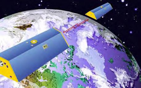
1 Tandem-L: A Mission Proposal for Monitoring Dynamic Earth Processes A. Moreira, G. Krieger, M. Younis, I. Hajnsek, K. Papathanassiou, M. Eineder, P. Dekker, F. De Zan German Aerospace Center (DLR)


")
2 Dynamic Processes on the Earth Surface Deforestation, Degradation, Fires* (REDD) Forest Biomasse Change* Biodiversity Earthquakes Volcanic Activities Land Slides Sea Ice Extent* Permafrost* Glacier & Ice Cap Dynamics* Soil Moisture* Flooding Ocean Currents* *) Essential Climate Variables


3 Carbon Balance and Vegetation The terrestrial carbon is the greatest unknown in the carbon cycle 6.4 ± ± 0.1 =Σ Carbon accumulation in the atmosphere Sink Sources Fossil fuels 1.6 ± 1.1 Land use change Ocean sink 2.2 ± 0.4 Unknown terrestrial sink Numbers in Billions of Tons Carbon / Year (IPCC) 2.6 ± 1.7


4 Forest and Carbon Biomass and the spatial distribution of carbon (50% of the biomass is Carbon) Global biomass distribution and its dynamic are widely unknown! Amazon basin the estimation ranges from 39 to 93 GtC


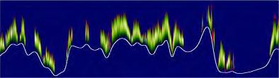
5 3-D Structure Mode Polarimetric Backscattering Polarimetric SAR Interferometry (Pol-InSAR) 3-D D Forest Structure Forest height and Biomass Tomography


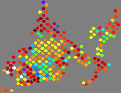
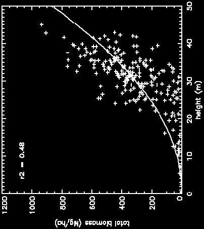
6 Forest Height Estimation (3D Structure Mode) Pol-InSAR Forest Height [m] Forest Height (in Situ) [m]


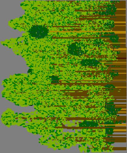
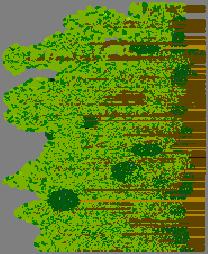
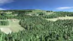
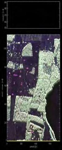
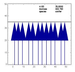
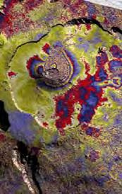
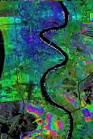
7 Traunstein Test Site Forest type Temperate Topography Moderate slopes 2003 Oct. Height 25 ~ 35m Species N. Spruce, E. Beech, White Fir Biomass 40 ~ 450 t/ha HV Amplitude Image 0m Pol-InSAR Forest Height Elevation Model


8 Traunstein Test Site 2003 Oct June m


")


9 Biomass Estimation from Height + Structure Profile Decomposition (Series Expansion) Combination of Multiple Single-Pass Interferograms f(z) pass 1 Example (Testsite Bayerischer Wald) pass 2


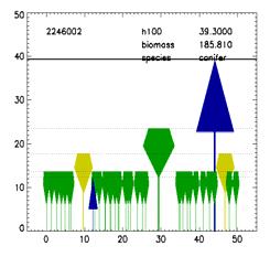
10 Structure - Biomass Allometry B = 3.11 H 3 i= 0 j= 1 a P j j a 1 a 2 a 3 Nationalpark Bayrischer Wald Ebersberger Forst Bürgerwald Traunstein Three Legendre polynomials explain the 92% of the total biomass!!! VU 10 > Autor Name
11 Dynamic Processes on the Earth Surface Deforestation, Degradation, Fires* (REDD) Forest Biomasse Change* Biodiversity Earthquakes Volcanic Activities Land Slides Sea Ice Extent* Permafrost* Glacier & Ice Cap Dynamics* Soil Moisture* Flooding Ocean Currents* *) Essential Climate Variables
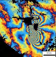

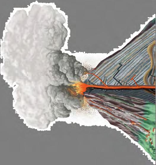


12 Deformation Mode Earthquakes measurement of deformations of mm cm Volcanoes λ/2 12 cm Subsidence Land & Sea Ice systematic multi-temporal acquisitions (image stacks)


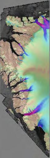

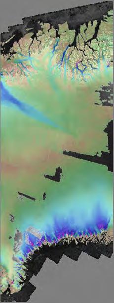
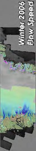
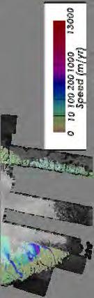

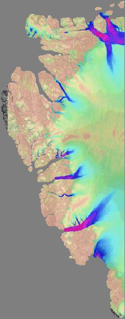
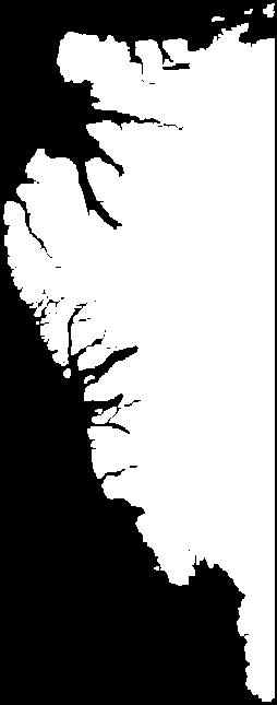


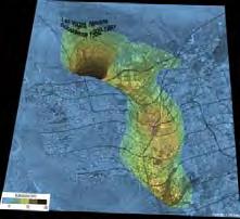
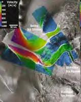
13 Cryosphere: Ice Motion and Topography of Glaciers ICESAT GRACE 15 km trackdistance at equator CryoSAT-2 > 200 km spatial resolution TanDEM-X 15 km x 250 m spatial resolution 1 year for global coverage Tandem-L 3 10 m resolution weekly coverage Tandem-L provides unique & complementary information: 3D Ice flow Ice Structure DEM weekly coverage, high resolution Courtesy: Ian Joughin


14 Hydrosphere: Soil Moisture SMOS SMAP km resolution km resolution Tandem-L 3 10 m resolution weekly coverage Tandem-L provides unique & complementary information: soil moisture water level changes river & ocean currents weekly coverage & high resolution 10 0 [vol.%]


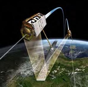
15 Mission Concept


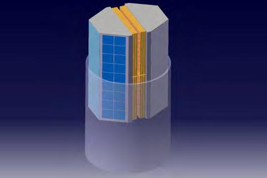
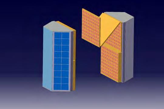
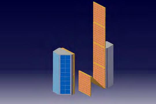
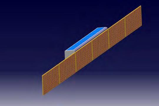
16 Radar System Concepts at start of DLR/JPL collaboration Planar Array with Digital Beamforming Reflector with Analog Beamforming
17 Digital Beamforming with Reflector Antennas digital feed array with T/R modules
18 Digital Beamforming with Reflector Antennas digital feed array with T/R modules
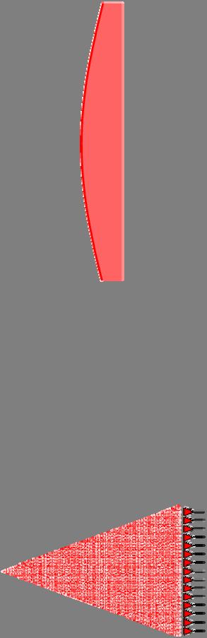
19 Digital Beamforming with Reflector Antennas


20 Tandem-L Science Products Resolution Revisit Biosphere Forest height Above ground biomass Vertical forest structure m 16 days - seasonal Plate tectonics Geo-/ Lithosphere Volcanoes Landslides m weekly Deformation Glacier flow weekly Soil moisture weekly Cryo- & Hydrosphere Water level change Snow water equivalent m on demand seasonal Ice structure Change seasonal Ocean Currents weekly Global Digital Terrain and surface model m yearly


21 Dynamic Earth Monitoring and Climate Change Tandem-L: A proposal for a radar mission for environmental and climate change research
Surface Deformation Measurements Scientific Requirements & Challenges
 Surface Deformation Measurements Scientific Requirements & Challenges 1st Science and Application Workshop for Germany-Japan Next-Generation SAR M. Eineder, C. Minet, A. Parizzi Tokyo, 27.6.2013 Tandem-L
Interferometric Synthetic Aperture Radar (InSAR) and GGOS. Andrea Donnellan NASA/JPL February 21, 2007
 and GGOS. Andrea Donnellan NASA/JPL February 21, 2007") Interferometric Synthetic Aperture Radar (InSAR) and GGOS Andrea Donnellan NASA/JPL February 21, 2007 Sources for Science Objectives Fourth component of EarthScope Involvement: NSF, NASA, USGS, Universities
Interferometric Synthetic Aperture Radar (InSAR) and GGOS Andrea Donnellan NASA/JPL February 21, 2007 Sources for Science Objectives Fourth component of EarthScope Involvement: NSF, NASA, USGS, Universities
Radar Remote Sensing: Monitoring Ground Deformations and Geohazards from Space
 Radar Remote Sensing: Monitoring Ground Deformations and Geohazards from Space Xiaoli Ding Department of Land Surveying and Geo-Informatics The Hong Kong Polytechnic University A Question 100 km 100 km
Model based forest height estimation with ALOS/PalSAR: A first study.
 Model based forest height estimation with ALOS/PalSAR: A first study. K.P. Papathanassiou*, I. Hajnsek*, T.Mette*, S.R. Cloude** and A. Moreira* * (DLR) (DLR-HR) Oberpfaffenhofen, Germany ** AEL Consultants
Unit 2: The World in Spatial Terms (Lessons 6-7)
") Unit 2: The World in Spatial Terms (Lessons 6-7) Physical Features of Earth Create Challenges and Opportunities The physical features of Earth create both challenges and opportunities for the people living
Unit 2: The World in Spatial Terms (Lessons 6-7) Physical Features of Earth Create Challenges and Opportunities The physical features of Earth create both challenges and opportunities for the people living
RADAR Remote Sensing Application Examples
 RADAR Remote Sensing Application Examples! All-weather capability: Microwave penetrates clouds! Construction of short-interval time series through cloud cover - crop-growth cycle! Roughness - Land cover,
GG S. Internal Vision of GGOS. Markus Rothacher. GFZ Potsdam
 Internal Vision of GGOS Markus Rothacher GFZ Potsdam GGOS Retreat DGFI in Munich February 15-16, 2006 Contents Motivation Four Levels of Products of the IAG Services: First Level: Raw Data Collection Second
Airborne Holographic SAR Tomography at L- and P-band
 Airborne Holographic SAR Tomography at L- and P-band O. Ponce, A. Reigber and A. Moreira. Microwaves and Radar Institute (HR), German Aerospace Center (DLR). 1 Outline Introduction to 3-D SAR Holographic
EasyChair Preprint. Height Accuracy and Data Coverage for the Final Global TanDEM-X DEM Data
 EasyChair Preprint 123 Height Accuracy and Data Coverage for the Final Global TanDEM-X DEM Data Christopher Wecklich, Carolina Gonzalez and Paola Rizzoli EasyChair preprints are intended for rapid dissemination
Making a case for full-polarimetric radar remote sensing
 Making a case for full-polarimetric radar remote sensing Jeremy Nicoll Alaska Satellite Facility, University of Alaska Fairbanks 1 Polarization States of a Coherent Plane Wave electric field vector vertically
An Introduction to PolSAR-Ap: Exploitation of Fully Polarimetric SAR Data for Application Demonstration
 An Introduction to PolSAR-Ap: Exploitation of Fully Polarimetric SAR Data for Application Demonstration Irena Hajnsek, Matteo Pardini, Kostas Papathanassiou, Shane Cloude, Juan M. Lopez-Sanchez, David
GLOBAL FOREST CLASSIFICATION FROM TANDEM-X INTERFEROMETRIC DATA: POTENTIALS AND FIRST RESULTS
 GLOBAL FOREST CLASSIFICATION FROM TANDEM-X INTERFEROMETRIC DATA: POTENTIALS AND FIRST RESULTS Michele Martone, Paola Rizzoli, Benjamin Bräutigam, Gerhard Krieger Microwaves and Radar Institute German Aerospace
SAR interferometry Status and future directions. Rüdiger Gens
 SAR interferometry Status and future directions Rüdiger Gens Polarimetric InSAR Polarimetric InSAR InSAR - Status and future directions sensitivity to changes in surface scattering, even in the presence
Paul A. Rosen Jet Propulsion Laboratory, California Institute of Technology. UNAVCO Workshop Boulder, Colorado March 10, 2010
 GSHAP L. Wood, P. Worfolk et al., SaVi - Satellite constellation Visualisation software, http://savi.sf.net/, 2010. Paul A. Rosen Jet Propulsion Laboratory, California Institute of Technology UNAVCO Workshop
Moore County Schools. High School Level
 Moore County Schools High School Level EARTH AND ENVIRONMENTAL SCIENCE Science, by nature, is an inquiry-based discipline whereby students gain knowledge through observation and experimentation. Scientific
ESA Status Report. ET-SAT-11, WMO, Geneva, CH, 4 April Prepared by Earth Observation Programmes Directorate
 ESA Status Report ET-SAT-11, WMO, Geneva, CH, 4 April 2017 Prepared by Earth Observation Programmes Directorate Presented by Ivan Petiteville, ESA, Earth Observation Programmes Issue/Revision: 0.0 Reference:
DIFFERENTIAL INSAR STUDIES IN THE BOREAL FOREST ZONE IN FINLAND
 DIFFERENTIAL INSAR STUDIES IN THE BOREAL FOREST ZONE IN FINLAND Kirsi Karila (1,2), Mika Karjalainen (1), Juha Hyyppä (1) (1) Finnish Geodetic Institute, P.O. Box 15, FIN-02431 Masala, Finland, Email:
Snow property extraction based on polarimetry and differential SAR interferometry
 Snow property extraction based on polarimetry and differential SAR interferometry S. Leinß, I. Hajnsek Earth Observation and Remote Sensing, Institute of Enviromental Science, ETH Zürich TerraSAR X and
Disciplinary Core List of Standards (NGSS) for 3-5 Earth Science Progression - 3-ESS2 Earth s Systems ESS2.D Weather and Climate -
 for 3-5 Earth Science Progression - 3-ESS2 Earth s Systems ESS2.D Weather and Climate -") Disciplinary Core List of Standards (NGSS) for 3-5 Earth Science Progression - 3-ESS2 Earth s Systems ESS2.D Weather and Climate - Scientists record patterns of the weather across different times and areas
Disciplinary Core List of Standards (NGSS) for 3-5 Earth Science Progression - 3-ESS2 Earth s Systems ESS2.D Weather and Climate - Scientists record patterns of the weather across different times and areas
Biosphere. All living things, plants, animals, (even you!) are part of the zone of the earth called the biosphere.
 are part of the zone of the earth called the biosphere.") Unit 1 Study Guide Earth s Spheres Biosphere All living things, plants, animals, (even you!) are part of the zone of the earth called the biosphere. Hydrosphere Water covers ¾ of the earth, made up mostly
Unit 1 Study Guide Earth s Spheres Biosphere All living things, plants, animals, (even you!) are part of the zone of the earth called the biosphere. Hydrosphere Water covers ¾ of the earth, made up mostly
BIOGEOCHEMICAL CYCLES
 BIOGEOCHEMICAL CYCLES BASICS Biogeochemical Cycle: The complete path a chemical takes through the four major components, or reservoirs, of Earth s system (atmosphere, lithosphere, hydrosphere and biosphere)
National Aeronautics and Space Administration. Earth Day is everyday at NASA. activity booklet
 National Aeronautics and Space Administration Earth Day is everyday at NASA activity booklet Earth Day is everyday at NASA NASA s Fleet of Earth Observing Satellites ACRIMSAT Landsat 7 Aqua SORCE Terra
Chapter 2 Earth s Interlocking Systems pg The Earth and Its Forces pg
 Chapter 2 Earth s Interlocking Systems pg. 24 55 2 1 The Earth and Its Forces pg. 27 33 Connecting to Your World and Internal Forces Shaping the Earth The Earth is unique in the solar system because it
Dual-Frequency Ku- Band Radar Mission Concept for Snow Mass
 Dual-Frequency Ku- Band Radar Mission Concept for Snow Mass Chris Derksen Environment and Climate Change Canada Study Team: Climate Research Division/Meteorological Research Division, ECCC Canadian Space
Copernicus Today and Tomorrow GEO Week Group on Earth Observation Geneva, 16 January 2014 The Copernicus Space Infrastructure
 Copernicus Today and Tomorrow GEO Week Group on Earth Observation Geneva, 16 January 2014 The Copernicus Space Infrastructure Thomas Beer, Policy Coordinator, Copernicus Space Office, ESA-ESRIN, Frascati
Breakout Session III Evolving landscapes and global environmental change
 Breakout Session III Evolving landscapes and global environmental change 1. Hydrology and critical zone imaging 2. Glaciology: Instrumenting glaciers and ice sheets 3. Polar networks and glacial isostatic
Watch for Week 8/9 Review Assessment
 Wednesday, October 25, 2017 Exam 2 results, key is posted on the main course website. Please check to make sure there are no errors in the scoring of the Scantron portion of the exam (note the scantron
Future SAR mission concepts
 Future SAR mission concepts PREMIER M. Arcioni, M. Aguirre, P. Bensi, S. D Addio, K. Engel, F. Fois, F. Hélière, M. Kern, A. Lecuyot, C.C. Lin, M. Ludwig, K. Scipal, P. Silvestrin ESTEC, Keplerlaan 1,
Physical Geography: Patterns, Processes, and Interactions, Grade 11, University/College Expectations
 Geographic Foundations: Space and Systems SSV.01 explain major theories of the origin and internal structure of the earth; Page 1 SSV.02 demonstrate an understanding of the principal features of the earth
A Living Planet. Chapter PHYSICAL GEOGRAPHY. What you will learn in this chapter. Summary of the chapter
 QUIT Main Ideas What you will learn in this chapter Summary Summary of the chapter Test your geographic knowledge by playing the. Main Ideas Section 1: The Earth Inside and Out The earth is the only habitable
Prentice Hall: Science Explorer, 16 Book Series 2005 Correlated to: Alabama Science Standards for Earth and Space Science Core (Grade 6)
") Alabama Science Standards for Earth and Space Science Core (Grade 6) 1. Identify global patterns of atmospheric movement, including El Niño, the Gulf Stream, the jet stream, the Coriolis effect, and global
Alabama Science Standards for Earth and Space Science Core (Grade 6) 1. Identify global patterns of atmospheric movement, including El Niño, the Gulf Stream, the jet stream, the Coriolis effect, and global
Carbon Cycle Activity
 David Faure, InThinking www.biology-inthinking.co.uk Carbon Cycle Activity IB Biology Different types of Carbon Carbon Dioxide Gas Dissolved Carbon dioxide Carbohydrates (e.g. glucose) Hydrogen carbonate
HOW GEOGRAPHY AND GEOLOGY AFFECT BIOLOGICAL DIVERSITY
 HOW GEOGRAPHY AND GEOLOGY AFFECT BIOLOGICAL DIVERSITY Factors Affecting Extinction Rates Natural Factors Climate change Cataclysmic event (volcano, earthquake) Human Activities Habitat Loss/Fragmentation
System. A system is a set of connected things or parts forming a complex whole.
 Earth Systems What is a system? System A system is a set of connected things or parts forming a complex whole. Open vs. Closed System Open vs. Closed System Open System a system in which both energy and
Sentinel-1 Mission Status
 Sentinel-1 Mission Status Pierre Potin, Sentinel-1 Mission Manager, ESA Luca Martino, Technical Support Engineer, ESA... and the Sentinel-1 operations team PSTG SAR Coordination Working Group 14 December
ALOS-2 Basic Observation Scenario (First Edition) January 10, 2014 JAXA/ALOS-2 Project
 January 10, 2014 JAXA/ALOS-2 Project") ALOS-2 Basic Observation Scenario (First Edition) January 10, 2014 JAXA/ALOS-2 Project 1 1.First edition 2.Purpose and Background 3.Approach of the Basic Observation Scenario 4.Basic Observation
ALOS-2 Basic Observation Scenario (First Edition) January 10, 2014 JAXA/ALOS-2 Project 1 1.First edition 2.Purpose and Background 3.Approach of the Basic Observation Scenario 4.Basic Observation
What are the consequences of melting pack ice?
 The Hydrosphere s Cryosphere: A-Pack Ice: (Sea Ice) They are large sheets of ice found in the oceans around Antarctica and in the Arctic Ocean. Smaller ones are called ice floes. Example 1: What are the
New A-Level Physical Geography
 Half Term 1 3.1 Physical Geography: 3.1.5 Hazards: Plate Tectonics This optional section of our specification focuses on the lithosphere and the atmosphere, which intermittently but regularly present natural
Pol-InSAR Calibration of ESA s BIOMASS Mission
 Pol-InAR Calibration of EA s BIOMA Mission K. Papathanassiou & J-. Kim German Aerospace Center (DLR (DLR-HR biomass Primary Mission Objectives. Reducing the major uncertainties in carbon fluxes linked
DLR s TerraSAR-X contributes to international fleet of radar satellites to map the Arctic and Antarctica
 DLR s TerraSAR-X contributes to international fleet of radar satellites to map the Arctic and Antarctica The polar regions play an important role in the Earth system. The snow and ice covered ocean and
Chapter 2: Physical Geography
 Chapter 2: Physical Geography Pg. 39-68 Learning Goals for Chp2: q q q q q Explain how the Earth moves in space and why seasons change. Outline the factors that influence climate and recognize different
hydrosphere notes nwebsite.notebook November 30, 2015 The Hydrosphere
 hydrosphere notes nwebsite.notebook The Hydrosphere 1 Earth's outer layer of water found as liquid gas or solid. Stats: 71% of earth is water 97.5% of this water is in the oceans 2.5% left is rivers, lakes,
Geography Class XI Fundamentals of Physical Geography Section A Total Periods : 140 Total Marks : 70. Periods Topic Subject Matter Geographical Skills
 Geography Class XI Fundamentals of Physical Geography Section A Total Periods : 140 Total Marks : 70 Sr. No. 01 Periods Topic Subject Matter Geographical Skills Nature and Scope Definition, nature, i)
CHAPTER-7 INTERFEROMETRIC ANALYSIS OF SPACEBORNE ENVISAT-ASAR DATA FOR VEGETATION CLASSIFICATION
 147 CHAPTER-7 INTERFEROMETRIC ANALYSIS OF SPACEBORNE ENVISAT-ASAR DATA FOR VEGETATION CLASSIFICATION 7.1 INTRODUCTION: Interferometric synthetic aperture radar (InSAR) is a rapidly evolving SAR remote
Components of the Climate System. Lecture 2: Earth s Climate System. Pop Quiz. Sub-components Global cycles What comes in What goes out
 Lecture 2: Earth s Climate System Components of the Climate System terrestrial radiation Atmosphere Ocean solar radiation Land Energy, Water, and Biogeochemistry Cycles Sub-components Global cycles What
Lecture 2: Earth s Climate System
 Lecture 2: Earth s Climate System terrestrial radiation solar radiation Atmosphere Ocean Solid Earth Land Energy, Water, and Biogeochemistry Cycles Sub-components Global cycles What comes in What goes
Studies of Austfonna ice cap (Svalbard) using radar altimetry with other satellite techniques
 using radar altimetry with other satellite techniques") 15 Years of progress in Radar Altimetry Symposium Ocean surface topography science team (OSTST) International Doris Service (IDS) Workshop, Argo Workshop 13-18 March 2006, Venice, Italy Alexei V. Kouraev,
15 Years of progress in Radar Altimetry Symposium Ocean surface topography science team (OSTST) International Doris Service (IDS) Workshop, Argo Workshop 13-18 March 2006, Venice, Italy Alexei V. Kouraev,
Infrastructure monitoring using SAR interferometry
 Infrastructure monitoring using SAR interferometry Hossein Nahavandchi Roghayeh Shamshiri Norwegian University of Science and Technology (NTNU), Department of Civil and Environmental Engineering Geodesy
Radar mapping of snow melt over mountain glaciers in High Mountain Asia Mentor: Tarendra Lakhankar Collaborators: Nir Krakauer, Kyle MacDonald and
 Radar mapping of snow melt over mountain glaciers in High Mountain Asia Mentor: Tarendra Lakhankar Collaborators: Nir Krakauer, Kyle MacDonald and Nick Steiner How are Glaciers Formed? Glaciers are formed
The Earth Explorer Missions - Current Status
 EOQ N 66 July 2000 meteorology earthnet remote sensing solid earth future programmes Earth Observation Quarterly The Earth Explorer Missions - Current Status G. Mégie (1) and C.J. Readings (2) (1) Institut
ALOS-2 Basic Observation Scenario (First Edition) October 10, 2014 JAXA/ALOS-2 Project
 October 10, 2014 JAXA/ALOS-2 Project") ALOS-2 Basic Observation Scenario (First Edition) October 10, 2014 JAXA/ALOS-2 Project 1 Revision details Rev. Date Page Revision details A October 10, 2014 P13,P30 P17 Updated the date of Basic Observation
ALOS-2 Basic Observation Scenario (First Edition) October 10, 2014 JAXA/ALOS-2 Project 1 Revision details Rev. Date Page Revision details A October 10, 2014 P13,P30 P17 Updated the date of Basic Observation
Detecting an area affected by forest fires using ALOS PALSAR
 Detecting an area affected by forest fires using ALOS PALSAR Keiko Ishii (1), Masanobu Shimada (2), Osamu Isoguchi (2), Kazuo Isono (1) (1)Remote Sensing Technology Center of Japan (2)Japan Aerospace Exploration
Tuesday, September 05, 2017 Planet Earth
 Tuesday, September 05, 2017 Planet Earth Objective: Describe the solar system and Earth s location in it. Identify Earth s shape. Discuss Earth s structure. List Earth s landforms Do Now: What is a compass
GEOGRAPHY (029) CLASS XI ( ) Part A: Fundamentals of Physical Geography. Map and Diagram 5. Part B India-Physical Environment 35 Marks
 CLASS XI ( ) Part A: Fundamentals of Physical Geography. Map and Diagram 5. Part B India-Physical Environment 35 Marks") GEOGRAPHY (029) CLASS XI (207-8) One Theory Paper 70 Marks 3 Hours Part A Fundamentals of Physical Geography 35 Marks Unit-: Geography as a discipline Unit-3: Landforms Unit-4: Climate Unit-5: Water (Oceans)
GEOGRAPHY (029) CLASS XI (207-8) One Theory Paper 70 Marks 3 Hours Part A Fundamentals of Physical Geography 35 Marks Unit-: Geography as a discipline Unit-3: Landforms Unit-4: Climate Unit-5: Water (Oceans)
CLIMATE CHANGE AND REGIONAL HYDROLOGY ACROSS THE NORTHEAST US: Evidence of Changes, Model Projections, and Remote Sensing Approaches
 CLIMATE CHANGE AND REGIONAL HYDROLOGY ACROSS THE NORTHEAST US: Evidence of Changes, Model Projections, and Remote Sensing Approaches Michael A. Rawlins Dept of Geosciences University of Massachusetts OUTLINE
Current Status of the ALOS-2 Operation and PALSAR-2 Calibration Activities
 Current Status of the ALOS-2 Operation and PALSAR-2 Calibration Activities Takeshi Motohka, Ryo Natsuaki, Yukihiro Kankaku, Shinichi Suzuki, Masanobu Shimada (JAXA) Osamu Isoguchi (RESTEC) CEOS SAR CALVAL
This module presents remotely sensed assessment (choice of sensors and resolutions; airborne or ground based sensors; ground truthing)
") This module presents remotely sensed assessment (choice of sensors and resolutions; airborne or ground based sensors; ground truthing) 1 In this presentation you will be introduced to approaches for using
This module presents remotely sensed assessment (choice of sensors and resolutions; airborne or ground based sensors; ground truthing) 1 In this presentation you will be introduced to approaches for using
2 nd Asia CryoNet Workshop Current methods of measurement of the cryosphere in Asia consistency and issues
 2 nd Asia CryoNet Workshop Current methods of measurement of the cryosphere in Asia consistency and issues Dongqi Zhang, Cunde Xiao, Vladimir Aizen and Wolfgang Schöner Feb.5, 2016, Salekhard, Russia 1.
Geosphere Final Exam Study Guide
 Geosphere Final Exam Study Guide Chapter 1 Intro to Earth Systems 1. Name and describe Earth s 4 major spheres Geosphere-- nonliving, mostly solid rock divided into crust, mantle, and core Atmosphere a
European Space Agency
 Guidelines - Guidelines how/when to interact during the WebEx session: - Due to the number of attendees, please keep always your webcam and microphone switched-off - You can use anytime the chat to all
Interferometric Synthetic Aperture Radar (InSAR): Its Past, Present and Future
: Its Past, Present and Future") Interferometric Synthetic Aperture Radar (InSAR): Its Past, Present and Future by Zhong Lu, Ohig Kwoun, and Russell Rykhus Introduction Very simply, interferometric synthetic aperture radar (InSAR) involves
Interferometric Synthetic Aperture Radar (InSAR): Its Past, Present and Future by Zhong Lu, Ohig Kwoun, and Russell Rykhus Introduction Very simply, interferometric synthetic aperture radar (InSAR) involves
Dr. Simon Plank. German Remote Sensing Data Center (DFD), German Aerospace Center (DLR)
, German Aerospace Center (DLR)") Pre-survey suitability analysis of the differential and persistent scatterer synthetic ti aperture radar interferometry t method for deformation monitoring of landslides Dr. Simon Plank German Remote Sensing
Pre-survey suitability analysis of the differential and persistent scatterer synthetic ti aperture radar interferometry t method for deformation monitoring of landslides Dr. Simon Plank German Remote Sensing
Chapter 1 Section 2. Land, Water, and Climate
 Chapter 1 Section 2 Land, Water, and Climate Vocabulary 1. Landforms- natural features of the Earth s land surface 2. Elevation- height above sea level 3. Relief- changes in height 4. Core- most inner
AlOS-PALSAR data for Landslide Monitoring and Geological Mapping
 AlOS-PALSAR data for Landslide Monitoring and Geological Mapping Vern Singhroy, P-J Alasset, G Pavlic Canada Centre for Remote Sensing Ottawa, Canada vern.singhroy@ccrs.nrcan.gc.ca Objectives InSAR monitoring
Soil frost from microwave data. Kimmo Rautiainen, Jouni Pulliainen, Juha Lemmetyinen, Jaakko Ikonen, Mika Aurela
 Soil frost from microwave data Kimmo Rautiainen, Jouni Pulliainen, Juha Lemmetyinen, Jaakko Ikonen, Mika Aurela Why landscape freeze/thaw? Latitudinal variation in mean correlations (r) between annual
Formation of the Earth and Solar System. Radiometric dating of moon rocks, minerals, and meteorites. Size and composition of solar system objects
 Environmental Science: NGSS Curriculum Map 2016 - S. Kraemer, J. Crane, M. Thorn, S. Marz Time/Interval Essential Question Content Skills Assessment Standards Days: Unit 1: History of the Earth Crosscutting:
Earth s Major Terrerstrial Biomes. *Wetlands (found all over Earth)
") Biomes Biome: the major types of terrestrial ecosystems determined primarily by climate 2 main factors: Depends on ; proximity to ocean; and air and ocean circulation patterns Similar traits of plants
Biomes Biome: the major types of terrestrial ecosystems determined primarily by climate 2 main factors: Depends on ; proximity to ocean; and air and ocean circulation patterns Similar traits of plants
Anthropogenic (Tectonic) Earth-change: A Review Combining Anthropogenic climate Δ biosphere Δ cryosphere Δ lithosphere Δ hydrosphere Δ sediment Δ &
 Earth-change: A Review Combining Anthropogenic climate Δ biosphere Δ cryosphere Δ lithosphere Δ hydrosphere Δ sediment Δ &") Anthropogenic (Tectonic) Earth-change: A Review Combining Anthropogenic climate Δ biosphere Δ cryosphere Δ lithosphere Δ hydrosphere Δ sediment Δ & asthenosphere (magma) Δ into a new unified hypothesis
Anthropogenic (Tectonic) Earth-change: A Review Combining Anthropogenic climate Δ biosphere Δ cryosphere Δ lithosphere Δ hydrosphere Δ sediment Δ & asthenosphere (magma) Δ into a new unified hypothesis
Polar Space Task Group Permafrost Review of Requirements, Achievements and Expected Data
 Permafrost Review of Requirements, Achievements and Expected Data Annett Bartsch HORIZON2020 project NUNATARYUK (lead AWI with focus on coastal erosion and infrastructure) Dedicated Pleiades acquisitions
REMOTE SENSING OF PERMAFROST IN NORTHERN ENVIRONMENTS
 REMOTE SENSING OF PERMAFROST IN NORTHERN ENVIRONMENTS What is permafrost? What can we monitor with satellite data? Permafrost is an Essential Climate Variable About 25 % of the land surface is underlain
Climate 1: The Climate System
 Climate 1: The Climate System Prof. Franco Prodi Institute of Atmospheric Sciences and Climate National Research Council Via P. Gobetti, 101 40129 BOLOGNA SIF, School of Energy, Varenna, July 2014 CLIMATE
New Era of Global Monitoring by ALOS-2: Advanced Land Observing Satellite-2 DAICHI-2 Yuko Suzuki
 New Era of Global Monitoring by ALOS-2: Advanced Land Observing Satellite-2 DAICHI-2 Yuko Suzuki International Relations and Research Department Japan Aerospace Exploration Agency (JAXA) 1 Dawning Era
ESA s Earth Observation Programmes
 ESA s Earth Observation Programmes 2015 DRAGON Symposium Interlaken, 23 June 2015 Maurice Borgeaud Head of the Department Science, Applications, and Future Technologies ESA Earth Observation Programmes
Lithosphere: (Rocky Sphere) Solid, rocky, outer layer of the Earth. Includes the crust and part of the upper mantle. Lithosphere
 Solid, rocky, outer layer of the Earth. Includes the crust and part of the upper mantle. Lithosphere") Lithosphere: (Rocky Sphere) Solid, rocky, outer layer of the Earth. Includes the crust and part of the upper mantle. Lithosphere Permafrost Permafrost Ground that is at a temperature of 0 or below for
Lithosphere: (Rocky Sphere) Solid, rocky, outer layer of the Earth. Includes the crust and part of the upper mantle. Lithosphere Permafrost Permafrost Ground that is at a temperature of 0 or below for
The Scope of Earth Science
 Earth science Earth Science The Scope of Earth Science The field of Earth Science can be broken into four major areas of specialization: astronomy, meteorology, geology, and oceanography. 1. Astronomy
1. TEACHER COPY- Return this at the end of class! 2. ANSWER THESE QUESTIONS ON A SEPARATE SHEET OF PAPER 3. WRITE THE QUESTION AND ANSWER!
 EE Science FINAL REVIEW QUESTIONS # 1. TEACHER COPY- Return this at the end of class! 2. ANSWER THESE QUESTIONS ON A SEPARATE SHEET OF PAPER 3. WRITE THE QUESTION AND ANSWER! Be as detailed as possible:
2008 JC2 H2 GEOGRAPHY: PIONEER JUNIOR COLLEGE PRELIMINARY EXAMS. Figure 1 for Question 1
 PHYSICAL GEOGRAPHY Figure 1 for Question 1 Figure 2 for Question 2 Tropical air mass source regions Figure 3 for Question 3 Figure 4 for Question 4 Volcanic gases Figure 5 for Question 5 EITHER Photograph
Status DLR (TerraSAR X / TanDEM X)
") SAR Coordination Working Meeting 5 Status DLR (TerraSAR X / TanDEM X) Dana Floricioiu, Achim Roth Imaging Requirements for TerraSAR X & TanDEM X Missions Ice Sheets: TSX supports Greenland outlet glaciers,
SAR Coordination Working Meeting 5 Status DLR (TerraSAR X / TanDEM X) Dana Floricioiu, Achim Roth Imaging Requirements for TerraSAR X & TanDEM X Missions Ice Sheets: TSX supports Greenland outlet glaciers,
InSAR atmospheric effects over volcanoes - atmospheric modelling and persistent scatterer techniques
 InSAR atmospheric effects over volcanoes - atmospheric modelling and persistent scatterer techniques Rachel Holley 1,2, Geoff Wadge 1, Min Zhu 1, Ian James 3, Peter Clark 4 Changgui Wang 4 1. Environmental
Sentinel-1 Mission Status
 Sentinel-1 Mission Status Pierre Potin, Sentinel-1 Mission Manager 5TH GEOGLAM RAPP Workshop 16-17 May 2017, ESRIN Sentinel-1: Copernicus radar imaging mission for ocean, land, emergency Part of the Copernicus
ALOS PI Symposium 2009, 9-13 Nov 2009 Hawaii MOTION MONITORING FOR ETNA USING ALOS PALSAR TIME SERIES
 ALOS PI Symposium 2009, 9-13 Nov 2009 Hawaii ALOS Data Nodes: ALOS RA-094 and RA-175 (JAXA) MOTION MONITORING FOR ETNA USING ALOS PALSAR TIME SERIES Urs Wegmüller, Charles Werner and Maurizio Santoro Gamma
UGRC 144 Science and Technology in Our Lives/Geohazards
 UGRC 144 Science and Technology in Our Lives/Geohazards Flood and Flood Hazards Dr. Patrick Asamoah Sakyi Department of Earth Science, UG, Legon College of Education School of Continuing and Distance Education
The Official CA State Science Education Standards for Earth Science K 8
 The Official CA State Science Education Standards for Earth Science K 8 Kindergarten The Earth is composed of land, air and water. As a basis for understanding this concept, students know: a. characteristics
ALOS-2 Basic Observation Scenario (3rd Edition Ver. A) August 15, 2018 JAXA/ALOS-2 Project
 August 15, 2018 JAXA/ALOS-2 Project") ALOS-2 Basic Observation Scenario (3rd Edition Ver. A) August 15, 2018 JAXA/ALOS-2 Project 1 Details of revision Version Date Page Details of revision A 2018/8/15 P4, 8, 14 Changed the observation mode
ALOS-2 Basic Observation Scenario (3rd Edition Ver. A) August 15, 2018 JAXA/ALOS-2 Project 1 Details of revision Version Date Page Details of revision A 2018/8/15 P4, 8, 14 Changed the observation mode
WHAT IS THE EARTH MADE OF? LITHOSPHERE AND HYDROSPHERE
 UNIT 8 WHAT IS THE EARTH MADE OF? LITHOSPHERE AND HYDROSPHERE TABLE OF CONTENTS 1 THE STRUCTURE OF THE EARTH... 2 2 THE FORMATION OF THE RELIEF: INTERNAL AND EXTERNAL FORCES.... 2 2.1 Internal forces:
Urban land and infrastructure deformation monitoring by satellite radar interferometry
 Urban land and infrastructure deformation monitoring by satellite radar interferometry Lei Zhang and Xiaoli Ding Department of Land Surveying and Geo-Informatics (LSGI) The Hong Kong Polytechnic University
Weather Forecasts and Climate AOSC 200 Tim Canty. Class Web Site: Lecture 27 Dec
 Weather Forecasts and Climate AOSC 200 Tim Canty Class Web Site: http://www.atmos.umd.edu/~tcanty/aosc200 Topics for today: Climate Natural Variations Feedback Mechanisms Lecture 27 Dec 4 2018 1 Climate
Important Note: The current 2004 SCOS will continue to be the operational standards in the and school years
 This document is designed to help North Carolina educators teach the s (Standard Course of Study). NCDPI staff are continually updating and improving these tools to better serve teachers. Earth/Environmental
The financial and communal impact of a catastrophe instantiated by. volcanoes endlessly impact on lives and damage expensive infrastructure every
 Chapter 1 Introduction The financial and communal impact of a catastrophe instantiated by geophysical activity is significant. Landslides, subsidence, earthquakes and volcanoes endlessly impact on lives
water erosion lithosphere Describe the process of erosion and deposition. chemical weathering Dissolving limestone is an example of.
 At one time, there was one large island off the coast of Mississippi and now it is two separate islands. What caused the island to be split into two? water erosion The crust and the top part of the upper
Georgia Standards of Excellence for Science Grade 6
 A Correlation of To the Georgia Standards of Excellence for Science A Correlation of,, Introduction This document demonstrates how, supports the Georgia Standards of Excellence for Science. Correlation
GEOSPATIAL ANALYSIS OF GLACIAL DYNAMICS OF SHIGAR AND SHAYOK BASINS. Syed Naseem Abbas Gilany 1
 GEOSPATIAL ANALYSIS OF GLACIAL DYNAMICS OF SHIGAR AND SHAYOK BASINS 1 OUTLINE Introduction Problem Statement / Rationale Objectives Material and Methods Study Area Datasets Required Data Analysis / Assessment
SIO15 Midterm 1, Monday Oct. 30, 2017 TEST VARIATION: 2
 SIO15 Midterm 1, Monday Oct. 30, 2017 TEST VARIATION: 2 1) Over the last 20 years, which of these natural disasters killed the most people in the U.S.? a) heat waves b) hurricanes c) lightning strikes
K&C Phase 4 Status report. Use of short-period ALOS-2 observations for vegetation characterization and classification
 K&C Phase 4 Status report Use of short-period ALOS-2 observations for vegetation characterization and classification Paul Siqueira University of Massachusetts, Amherst Science Team meeting #22 Tokyo, Japan,
Climate Roles of Land Surface
 Lecture 5: Land Surface and Cryosphere (Outline) Climate Roles Surface Energy Balance Surface Water Balance Sea Ice Land Ice (from Our Changing Planet) Surface Albedo Climate Roles of Land Surface greenhouse
Future Climate Change
 Future Climate Change How do you know whether to trust a prediction about the future? All predictions are based on global circulation models (GCMs, AOGCMs) - model accuracy is verified by its ability to
What is Earth Science? Earth science is the branch of science dealing with the constitution of the earth and its atmosphere.
 What is Earth Science? Earth science is the branch of science dealing with the constitution of the earth and its atmosphere. 1 2 The Branches of Earth Science Major Astronomy (celestial objects, space,
Exploring Geography. Chapter 1
 Exploring Geography Chapter 1 The Study of Geography Geography is the study of where people, places, and things are located and how they relate to each other. Greek meaning writing about or describing
Observed State of the Global Climate
 WMO Observed State of the Global Climate Jerry Lengoasa WMO June 2013 WMO Observations of Changes of the physical state of the climate ESSENTIAL CLIMATE VARIABLES OCEANIC ATMOSPHERIC TERRESTRIAL Surface
Grade Six. Macmillan McGraw-Hill: California Earth Science. Science/ Treasures Correlations
 Grade Six Macmillan McGraw-Hill: California Earth Science Science/ Treasures Correlations *This document was created for the purpose of helping teachers align the science and social studies programs with