Urban land and infrastructure deformation monitoring by satellite radar interferometry
|
|
|
- Christal Robbins
- 5 years ago
- Views:
Transcription
 The Hong Kong Polytechnic University lslzhang@polyu.edu.hk Acknowledgement Allen Liang, Songbo Wu, Yanan Du and Shona Tang")
1 Urban land and infrastructure deformation monitoring by satellite radar interferometry Lei Zhang and Xiaoli Ding Department of Land Surveying and Geo-Informatics (LSGI) The Hong Kong Polytechnic University Acknowledgement Allen Liang, Songbo Wu, Yanan Du and Shona Tang
2 Introduction InSAR Group at HKPolyU is working on Development of advanced InSAR processing algorithms to enhance the data quality, estimation accuracy and reliability, processing efficiency and technique applicability. Application of the developed InSAR technique to study the phenomena/events related to deformation/change associated with infrastructure instability and natural hazards. 2


3 Introduction Satellite Synthetic Aperture Radar Phase Phas e All-day and all-weather Large scale and spatial continuity High precision and no need of ground instruments Intensity Intensity 3

4 Introduction Spaceborne SAR Systems (Source:Alberto Moreira) 4

5 Introduction (Source:Alberto Moreira) 5
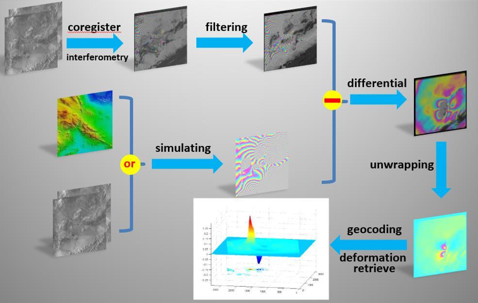
6 Introduction Pass 1 Pass 2 Ground deformation: 9 mm C band (~5.6cm) Phase phase shift: degrees Interferometric Synthetic Aperture Radar (InSAR): phase measurement 6


7 Introduction Phase image Amplitude image Image 1: Oct. 4, 1995 Image 2: Oct. 9, 1997 A 1 A φ 1 = 4π λ r 1 + ε 1 φ 2 = 4π λ r 2 + ε 2 7

8 Introduction Phase+amplitude images Interferometric Phase (phase difference): 4 ( r1 r2) 1 2 ( 1 2) Assume 1 2 4π(r 1 r 2 ሻ φ = φ 1 φ 2 = λ i i i i i i l, m topo, l, m defo, l, m atmo, l, m orbit, l, m noise, l, m N 2 8
9 Introduction 9


10 Introduction Underground activity Landslide Volcano Hilley et al., 2004, Science Pass 1Wicks et al., 2002, Science Pass 2 Earthquake Bawden et al., 2001, Science Massonnet et al., 1993, Nature Glacier Tectonics Goldstein et al., 1993, Science Wright et al., 2004, Science 10


11 Introduction InSAR measurements contains unwanted signals Error sources 11


12 TCPInSAR Temporarily Coherent Point InSAR - TCPInSAR Developed by InSAR group/polyu Unsupervised retrieval of ground deformation from radar data with high reliability and accuracy Wide applicability 12
13 TCPInSAR Du, Y.N., Zhang, L., Feng, G.C., Lu, Z., and Sun, Q. (2017). On the accuracy of topographic residuals retrieved by MTInSAR. IEEE Transactions on Geoscience and Remote Sensing. Chen, Z.W., Zhang, L., and Zhang, G. (2016). An Improved InSAR Image Co-Registration Method for Pairs with Relatively Big Distortions or Large Incoherent Areas. Sensors, 16(9), Zhang, L., Ding, X.L., Lu, Z. (2015), Ground deformation mapping by fusion of multi-temporal interferometric synthetic aperture radar images: a review, International Journal of Image and Data Fusion, DOI: / Zhang, L., Ding, X.L, Lu, Z., Jung, H.S., Hu, J., Feng, G.C. (2014), A novel multi-temporal InSAR model for joint estimation of deformation rates and orbital errors, IEEE Trans. Geos. Rem. Sens., 52(6): Zhang, L., Ding, X.L., and Lu, Z. (2013), Fusion of GPS and InSAR Measurements by Constrained Least Squares: an Alternative Way for the Suppression of Atmospheric Artifacts, 3rd IWIDF, Changbaishan, Jilin. Zhang, L., Lu, Z., Ding, X.L., Jung, H.S., Feng, G.C. and Lee, C.W. (2012) Mapping ground surface deformation using temporarily coherent point SAR interferometry: Application to Los Angeles Basin, Remote Sensing of Environments. 117, pp Zhang, L., Ding, X.L, Lu, Z. (2011) Ground settlement monitoring based on temporarily coherent points between two SAR acquisitions, ISPRS Journal of Photogrammetry and Remote Sensing, 66(1): Zhang, L., Ding, X.L., and Lu, Z. (2011), Modeling the PSInSAR time-series without phase unwrapping, IEEE Trans. Geos. Rem. Sens., 49(1): Zhang, L., Ding, X.L., and Lu, Z. (2011), Deformation rate estimation on changing landscapes using Temporarily Coherent Point InSAR, Fringe2011, Italy. 13


14 Applications Urban DEM reconstruction Data: TerraSAR-X Resolution: 3m Accuracy: sub-meter 14

15 DEM reconstruction over large areas by TCPInSAR 15


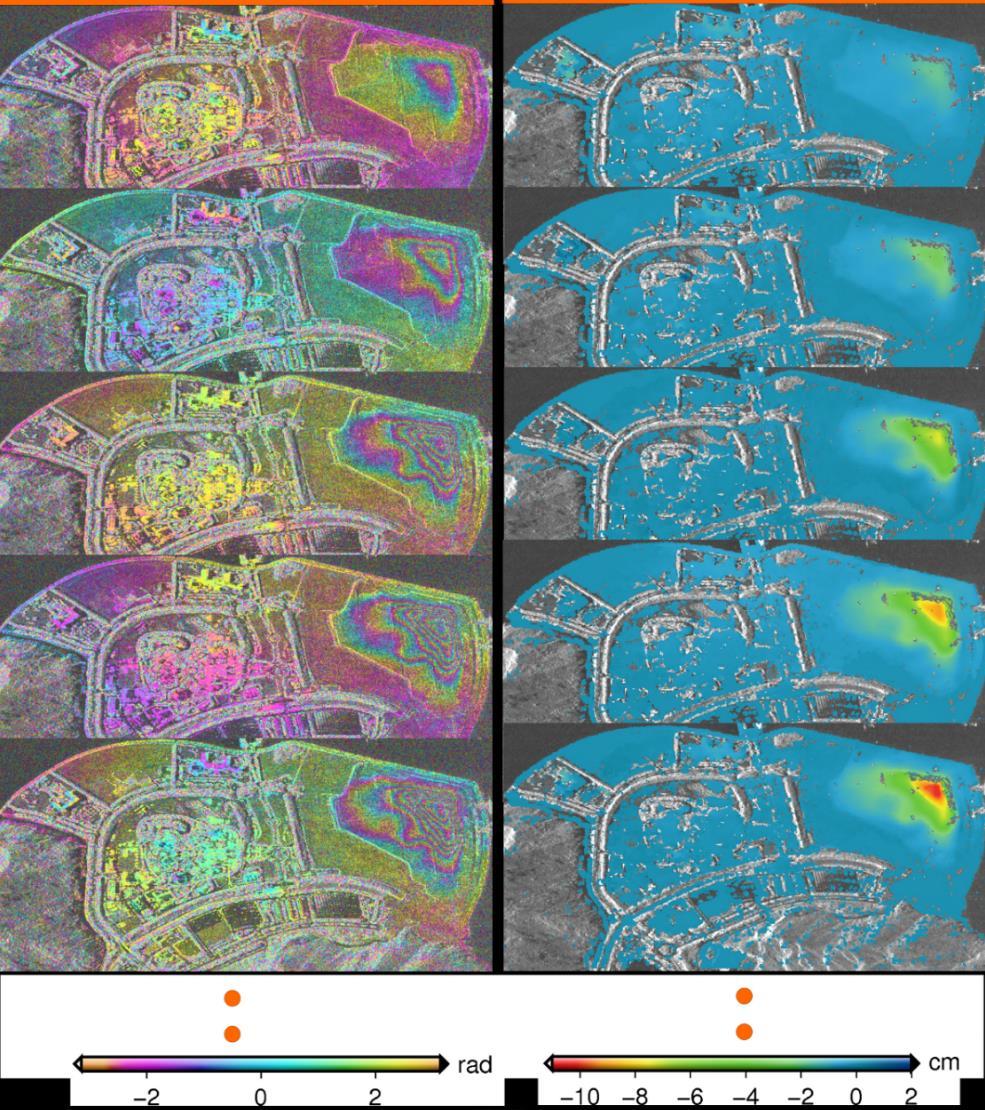
16 Applications Urban ground deformation mapping Area: Tianjin, China Period: to Data: 42 TerraSAR-X (3m) IFG:


")
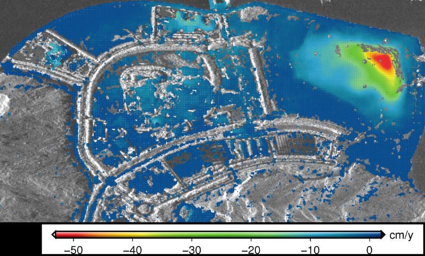
17 Applications Urban ground deformation mapping Area: Shenzhen, China Period: Data: Cosmo-SkyMed (3m) Significant Subsidence: 17
")
18 Applications Urban ground deformation mapping Area: Kowloon, Hong Kong Period: Data: 80 Cosmo-SkyMed (3m) 18

19 Applications Reclaimed land monitoring 19
 20")
20 Applications Reclaimed land monitoring (one color cycle represents 1.83cm) 20
21 Applications Reclaimed land monitoring 21


22 Applications Reclaimed land settlement Datasets:: CSK (3m) 22
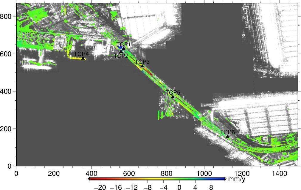
23 Applications Infrastructure stability monitoring 23

24 Applications Infrastructure stability Monitroing 24

")
25 Applications Natural hazard monitoring Data:L band ALOS/PALSAR data(>350 images) Period:
26 Applications Regional Surveillance 清境地区 26

27 Applications Natural hazard monitoring China Nepal Friendship Highway 27
28 Applications Natural hazards monitoring 28

29 Applications Natural hazards monitoring 29


30 Limitations However, InSAR is not a real-time monitoring tool and can only provide us 1D deformation map Solution: Integration with GNSS Anchor Monitoring System developed at LSGI/PolyU 30

31 Limitations However, InSAR is not a real-time monitoring tool and can only provide us 1D deformation map Integration with GNSS- Anchor Monitoring System Applications of Anchor Monitoring System 31
32 Conclusion Synthetic Aperture Radar (SAR) has been widely used for Earth remote sensing for more than 30 years. SAR has entered into a golden age. More than 15 spaceborne SAR sensors are being operated today and more than 10 new SAR systems will be launched within the next few years. It provides high-resolution, day-and-night and weather-independent images for a multitude of applications ranging from geoscience and climate change research, environmental and Earth system monitoring. Thanks to the advanced processing algorithms, InSAR technique is becoming more and more reliable and is qualified for routine deformation monitoring, especially over large areas. 32
Radar Remote Sensing: Monitoring Ground Deformations and Geohazards from Space
 Radar Remote Sensing: Monitoring Ground Deformations and Geohazards from Space Xiaoli Ding Department of Land Surveying and Geo-Informatics The Hong Kong Polytechnic University A Question 100 km 100 km
Modeling of Atmospheric Effects on InSAR Measurements With the Method of Stochastic Simulation
 Modeling of Atmospheric Effects on InSAR Measurements With the Method of Stochastic Simulation Z. W. LI, X. L. DING Department of Land Surveying and Geo-Informatics, Hong Kong Polytechnic University, Hung
Deformation measurement using SAR interferometry: quantitative aspects
 Deformation measurement using SAR interferometry: quantitative aspects Michele Crosetto (1), Erlinda Biescas (1), Ismael Fernández (1), Ivan Torrobella (1), Bruno Crippa (2) (1) (2) Institute of Geomatics,
The financial and communal impact of a catastrophe instantiated by. volcanoes endlessly impact on lives and damage expensive infrastructure every
 Chapter 1 Introduction The financial and communal impact of a catastrophe instantiated by geophysical activity is significant. Landslides, subsidence, earthquakes and volcanoes endlessly impact on lives
GEO-HAZARDS STUDIES BY PALSAR INTERFEROMETRY PI No: 390 Xiaoli Ding 1, Lei Zhang 1, Guangcai Feng 1, Mi Jiang 1, and Jun Hu 2, 1 The Hong Kong Polytec
 GEO-HAZARDS SUDIES BY PALSAR INERFEROMERY PI No: 390 Xiaoli Ding 1, Lei Zhang 1, Guangcai Feng 1, Mi Jiang 1, and Jun Hu 2, 1 he Hong Kong Polytechnic University, Hung Hom, KLN, Hong Kong 2 Central South
Subsidence-induced fault
 Surveying Monitoring underground coal mining-induced subsidence by Yaobin Sheng, Linlin Ge, Chris Rizos, University of New South Wales, and Yunjia Wang, China University of Mining and Technology This paper
MAPPING DEFORMATION OF MAN-MADE LINEAR FEATURES USING DINSAR TECHNIQUE
 MAPPING DEFORMATION OF MAN-MADE LINEAR FEATURES USING DINSAR TECHNIQUE H. Wu a, *, Y. Zhang a, J. Zhang a, X. Chen b a Key Laboratory of Mapping from Space of State Bureau of Surveying and Mapping, Chinese
Atmospheric Water Vapor Effect on GNSS Signals and InSAR Data
 Atmospheric Water Vapor Effect on GNSS Signals and InSAR Data Basic Concept and Preliminary Results F. Alshawaf 1, S. Hinz 1, A. Thiele 1 T. Fuhrmann 2, B. Heck 2, A. Knöpfler 2, X. Luo 2, M. Mayer 2,
Journal of Geodynamics
 Journal of Geodynamics 49 (2010) 161 170 Contents lists available at ScienceDirect Journal of Geodynamics journal homepage: http://www.elsevier.com/locate/jog Recent advances on surface ground deformation
where ν and γ are site- and season- specific constants, and P, T and U are modeled as h h h P h = P0 ( *10 ( h h0 )) T h = T0 k( h h0 )
) T h = T0 k( h h0 )") Ground Fissure Monitoring in China Based on PALSAR Data 430 Zhiwei Li (1) Jianjun Zhu (2), Zhengrong Zou (2), Wujiao Dai (2) (1) School of Geosciences & Info-Physics, Central South University, Changsha
Ground Fissure Monitoring in China Based on PALSAR Data 430 Zhiwei Li (1) Jianjun Zhu (2), Zhengrong Zou (2), Wujiao Dai (2) (1) School of Geosciences & Info-Physics, Central South University, Changsha
IEEE TRANSACTIONS ON GEOSCIENCE AND REMOTE SENSING, VOL. 52, NO. 6, JUNE
 IEEE TRANSACTIONS ON GEOSCIENCE AND REMOTE SENSING, VOL. 52, NO. 6, JUNE 2014 3529 A Novel Multitemporal InSAR Model for Joint Estimation of Deformation Rates and Orbital Errors Lei Zhang, Member, IEEE,
DETECTING ICE MOTION IN GROVE MOUNTAINS, EAST ANTARCTICA WITH ALOS/PALSAR AND ENVISAT/ASAR DATA
 DETECTING ICE MOTION IN GROVE MOUNTAINS, EAST ANTARCTICA WITH ALOS/PALSAR AND ENVISAT/ASAR DATA TIAN Xin (1), LIAO Mingsheng (1), ZHOU Chunxia (2), ZHOU Yu (3) (1) State Key Laboratory of Information Engineering
DIFFERENTIAL INSAR STUDIES IN THE BOREAL FOREST ZONE IN FINLAND
 DIFFERENTIAL INSAR STUDIES IN THE BOREAL FOREST ZONE IN FINLAND Kirsi Karila (1,2), Mika Karjalainen (1), Juha Hyyppä (1) (1) Finnish Geodetic Institute, P.O. Box 15, FIN-02431 Masala, Finland, Email:
Two-pass DInSAR uses an interferometric image pair and an external digital elevation model (DEM). Among the two singlelook complex (SLC) images, one i
. Among the two singlelook complex (SLC) images, one i") DIFFERENTIAL RADAR INTERFEROMETRY AND ITS APPLICATION IN MONITORING UNDERGROUND COAL MINING-INDUCED SUBSIDENCE Yaobin Sheng a, b, c, *, Yunjia Wang a, b, Linlin Ge c, Chris Rizos c a Jiangsu Key Laboratory
DIFFERENTIAL RADAR INTERFEROMETRY AND ITS APPLICATION IN MONITORING UNDERGROUND COAL MINING-INDUCED SUBSIDENCE Yaobin Sheng a, b, c, *, Yunjia Wang a, b, Linlin Ge c, Chris Rizos c a Jiangsu Key Laboratory
Interferometric Synthetic Aperture Radar (InSAR): Its Past, Present and Future
: Its Past, Present and Future") Interferometric Synthetic Aperture Radar (InSAR): Its Past, Present and Future by Zhong Lu, Ohig Kwoun, and Russell Rykhus Introduction Very simply, interferometric synthetic aperture radar (InSAR) involves
Interferometric Synthetic Aperture Radar (InSAR): Its Past, Present and Future by Zhong Lu, Ohig Kwoun, and Russell Rykhus Introduction Very simply, interferometric synthetic aperture radar (InSAR) involves
SAR interferometry Status and future directions. Rüdiger Gens
 SAR interferometry Status and future directions Rüdiger Gens Polarimetric InSAR Polarimetric InSAR InSAR - Status and future directions sensitivity to changes in surface scattering, even in the presence
MONITORING OF GLACIAL CHANGE IN THE HEAD OF THE YANGTZE RIVER FROM 1997 TO 2007 USING INSAR TECHNIQUE
 MONITORING OF GLACIAL CHANGE IN THE HEAD OF THE YANGTZE RIVER FROM 1997 TO 2007 USING INSAR TECHNIQUE Hong an Wu a, *, Yonghong Zhang a, Jixian Zhang a, Zhong Lu b, Weifan Zhong a a Chinese Academy of
Infrastructure Non-Linear Deformation Monitoring Via Satellite Radar Interferometry
 Available online at www.sciencedirect.com ScienceDirect Procedia Technology 00 (2014) 000 000 www.elsevier.com/locate/procedia CENTERIS 2014 - Conference on ENTERprise Information Systems / ProjMAN 2014
The Potential of High Resolution Satellite Interferometry for Monitoring Enhanced Oil Recovery
 The Potential of High Resolution Satellite Interferometry for Monitoring Enhanced Oil Recovery Urs Wegmüller a Lutz Petrat b Karsten Zimmermann c Issa al Quseimi d 1 Introduction Over the last years land
Infrastructure monitoring using SAR interferometry
 Infrastructure monitoring using SAR interferometry Hossein Nahavandchi Roghayeh Shamshiri Norwegian University of Science and Technology (NTNU), Department of Civil and Environmental Engineering Geodesy
DEM GENERATION AND ANALYSIS ON RUGGED TERRAIN USING ENVISAT/ASAR ENVISAT/ASAR MULTI-ANGLE INSAR DATA
 DEM GENERATION AND ANALYSIS ON RUGGED TERRAIN USING ENVISAT/ASAR ENVISAT/ASAR MULTI-ANGLE INSAR DATA Li xinwu Guo Huadong Li Zhen State Key Laboratory of Remote Sensing Science, Institute of Remote Sensing
MEASURING VOLCANIC DEFORMATION AT UNIMAK ISLAND FROM 2003 TO 2010 USING
 MEASURING VOLCANIC DEFORMATION AT UNIMAK ISLAND FROM 2003 TO 2010 USING WEATHER MODEL-ASSISTED TIME SERIES INSAR Gong, W. a, Meyer, F. J. a, Lee, C. W. b, Lu, Z. c, Freymueller, J a. a. Geophysical Institute,
Investigation of Slow-Moving Landslides from ALOS/PALSAR Images with TCPInSAR: A Case Study of Oso, USA
 Remote Sens. 2015, 7, 72-88; doi:10.3390/rs70100072 Article OPEN ACCESS remote sensing ISSN 2072-4292 www.mdpi.com/journal/remotesensing Investigation of Slow-Moving Landslides from ALOS/PALSAR Images
Dr. Simon Plank. German Remote Sensing Data Center (DFD), German Aerospace Center (DLR)
, German Aerospace Center (DLR)") Pre-survey suitability analysis of the differential and persistent scatterer synthetic ti aperture radar interferometry t method for deformation monitoring of landslides Dr. Simon Plank German Remote Sensing
Pre-survey suitability analysis of the differential and persistent scatterer synthetic ti aperture radar interferometry t method for deformation monitoring of landslides Dr. Simon Plank German Remote Sensing
P079 First Results from Spaceborne Radar Interferometry for the Study of Ground Displacements in Urban Areas SUMMARY
 P079 First Results from Spaceborne Radar Interferometry for the Study of Ground Displacements in Urban Areas C.M. Crosetto (Instituto de Geomatica), C.A. Casas (University of Barcelona), R.G. Ranieri (University
Urban Geo-Informatics John W Z Shi
 Urban Geo-Informatics John W Z Shi Urban Geo-Informatics studies the regularity, structure, behavior and interaction of natural and artificial systems in the urban context, aiming at improving the living
RADAR Remote Sensing Application Examples
 RADAR Remote Sensing Application Examples! All-weather capability: Microwave penetrates clouds! Construction of short-interval time series through cloud cover - crop-growth cycle! Roughness - Land cover,
Università di Roma La Sapienza, Facoltà d Ingegneria, Dipartimento di Idraulica,Trasporti e Strade (D.I.T.S.) 00185, Roma, Italy
 00185, Roma, Italy") DORIS FP7-EU PROJECT: EXPLOITATION OF 20 YEARS DINSAR DATA ARCHIVE FOR LANDSLIDE MONITORING Manunta M. (1), Calò F. (1), Paglia L., (1), Bonano M. (1,2), Lanari R. (1) (1) IREA-CNR, Via Diocleziano 328,
DORIS FP7-EU PROJECT: EXPLOITATION OF 20 YEARS DINSAR DATA ARCHIVE FOR LANDSLIDE MONITORING Manunta M. (1), Calò F. (1), Paglia L., (1), Bonano M. (1,2), Lanari R. (1) (1) IREA-CNR, Via Diocleziano 328,
THREE DIMENSIONAL DETECTION OF VOLCANIC DEPOSIT ON MOUNT MAYON USING SAR INTERFEROMETRY
 ABSTRACT THREE DIMENSIONAL DETECTION OF VOLCANIC DEPOSIT ON MOUNT MAYON USING SAR INTERFEROMETRY Francis X.J. Canisius, Kiyoshi Honda, Mitsuharu Tokunaga and Shunji Murai Space Technology Application and
Time-Series Displacement of Landslide In Danba County (China) Monitoried By the Small Baseline Subset (SBAS) technique
 Monitoried By the Small Baseline Subset (SBAS) technique") Article Time-Series Displacement of Landslide In Danba County (China) Monitoried By the Small Baseline Subset (SBAS) technique Bo Hu 1, *,Yang Wu 1 1 Guangdong university of technology, Guangzhou, 510006,
Article Time-Series Displacement of Landslide In Danba County (China) Monitoried By the Small Baseline Subset (SBAS) technique Bo Hu 1, *,Yang Wu 1 1 Guangdong university of technology, Guangzhou, 510006,
Mapping small reservoirs in semi-arid regions using multitemporal SAR: methods and applications
 Mapping small reservoirs in semi-arid regions using multitemporal SAR: methods and applications Donato Amitrano Gerardo Di Martino Antonio Iodice Daniele Riccio Giuseppe Ruello University of Napoli, Italy
ERS Track 98 SAR Data and InSAR Pairs Used in the Analysis
 ERS Track 98 SAR Data and InSAR Pairs Used in the Analysis Date 1 Date 2 Date 1 Date 2 Date 1 Date 2 Date 1 Date 2 7/17/1992 6/19/2000 7/17/1992 7/2/1993 9/10/1993 10/28/1996 9/3/1995 10/18/1999 9/25/1992
Atmospheric Effects on InSAR Measurements in Southern China and Australia: A Comparative Study
 Atmospheric Effects on InSAR Measurements in Southern China and Australia: A Comparative Study X. L. Ding a, *, L. Ge b, Z. W. Li a, C. Rizos b a Dept. of Land Surveying and Geo-Informatics, Hong Kong
In order to obtain a long term monitoring result for the Kilauea Volcano, ALOS PALSAR images taken on Track 287, Frame 38, ascending orbit with 21.5 d
 ALOS PALSAR OBSERVATION OF KILAUEA VOLCANO ACTIVITIES FROM 2006 TO 2009 Zhe Hu, Linlin Ge, Xiaojing Li, Kui Zhang, Alex Hay-Man NG and Chris Rizos Cooperative Research Centre for Spatial Information &
Advanced interpretation of land subsidence by validating multiinterferometric SAR data: the case study of Anthemountas basin (Northern Greece)
") Revision of paper Advanced interpretation of land subsidence by validating multiinterferometric SAR data: the case study of Anthemountas basin (Northern Greece) By Raspini et al. General comments This
Revision of paper Advanced interpretation of land subsidence by validating multiinterferometric SAR data: the case study of Anthemountas basin (Northern Greece) By Raspini et al. General comments This
Supplementary information. Analytical Techniques and Measurement Uncertainty
 Supplementary information Analytical Techniques and Measurement Uncertainty Interferomeric SAR (InSAR) allows measurement of millimetre-level surface displacements, including land subsidence, in the radar
3-Dimension Deformation Mapping from InSAR & Multiaperture. Hyung-Sup Jung The Univ. of Seoul, Korea Zhong Lu U.S. Geological Survey, U.S.A.
 3-Dimension Deformation Mapping from InSAR & Multiaperture InSAR Hyung-Sup Jung The Univ. of Seoul, Korea Zhong Lu U.S. Geological Survey, U.S.A. Outline Introduction to multiple-aperture InSAR (MAI) 3-D
CHAPTER-7 INTERFEROMETRIC ANALYSIS OF SPACEBORNE ENVISAT-ASAR DATA FOR VEGETATION CLASSIFICATION
 147 CHAPTER-7 INTERFEROMETRIC ANALYSIS OF SPACEBORNE ENVISAT-ASAR DATA FOR VEGETATION CLASSIFICATION 7.1 INTRODUCTION: Interferometric synthetic aperture radar (InSAR) is a rapidly evolving SAR remote
Time-series deformation monitoring over mining regions with SAR intensity-based offset measurements
 Remote Sensing Letters Vol. 4, No. 5, May 2013, 436 445 Time-series deformation monitoring over mining regions with SAR intensity-based offset measurements CHAOYING ZHAO, ZHONG LU* and QIN ZHANG College
Mitigation of Atmospheric Water-vapour Effects on Spaceborne Interferometric SAR Imaging through the MM5 Numerical Model
 PIERS ONLINE, VOL. 6, NO. 3, 2010 262 Mitigation of Atmospheric Water-vapour Effects on Spaceborne Interferometric SAR Imaging through the MM5 Numerical Model D. Perissin 1, E. Pichelli 2, R. Ferretti
Real Time Subsidence Monitoring Techniques in Undercity Mining and a Case Study: Zonguldak Undercity Applications-Turkey
 Real Time Subsidence Monitoring Techniques in Undercity Mining and a Case Study: Zonguldak Undercity Hakan AKCIN, Hakan S. KUTOGLU, Turkey Keywords: Undercity mining, subsidence, PALSAR, RADARSAT, GNSS.
Integration of InSAR and GIS for Monitoring of Subsidence Induced by Block Caving Mining
 Integration of InSAR and GIS for Monitoring of Subsidence Induced by Block Caving Mining Dr. Andrew JAROSZ and Mr. Hani ZAHIRI, Australia Key words: subsidence, block caving, mine deformation, GIS, InSAR,
DLR s TerraSAR-X contributes to international fleet of radar satellites to map the Arctic and Antarctica
 DLR s TerraSAR-X contributes to international fleet of radar satellites to map the Arctic and Antarctica The polar regions play an important role in the Earth system. The snow and ice covered ocean and
Observing Dam s Movements with Spaceborne SAR Interferometry
 Observing Dam s Movements with Spaceborne SAR Interferometry 26 Milan Lazecký, Daniele Perissin, Wang Zhiying, Lei Ling, and Qin Yuxiao Abstract Advantages of satellite synthetic aperture radar (SAR) interferometry
GPS and GIS Assisted Radar Interferometry
 GPS and GIS Assisted Radar Interferometry Linlin Ge, Xiaojing Li, Chris Rizos, and Makoto Omura Abstract Error in radar satellite orbit determination is a common problem in radar interferometry (INSAR).
MODELS TO PREDICT PERSISTENT SCATTERERS DATA DISTRIBUTION AND THEIR CAPACITY TO REGISTER MOVEMENT ALONG THE SLOPE
 MODELS TO PREDICT PERSISTENT SCATTERERS DATA DISTRIBUTION AND THEIR CAPACITY TO REGISTER MOVEMENT ALONG THE SLOPE Notti D., (1) Meisina C. (1), Zucca F. (1) and Colombo A. (2) (1) Dip. Di Scienze della
Implementation of Multi-Temporal InSAR to monitor pumping induced land subsidence in Pingtung Plain, Taiwan
 Implementation of Multi-Temporal InSAR to monitor pumping induced land subsidence in Pingtung Plain, Taiwan Presenter: Oswald Advisor: Chuen-Fa Ni Date: March 09, 2017 Literature Review Pingtung Plain
Improved PSI Performance for Landslide Monitoring Applications. J. Duro, R. Iglesias, P. Blanco-Sánchez, F. Sánchez and D. Albiol
 Improved PSI Performance for Landslide Monitoring Applications J. Duro, R. Iglesias, P. Blanco-Sánchez, F. Sánchez and D. Albiol Outline Area of Study Previous PSI (and others) studies Main conclusions
Ground deformation monitoring in Pearl River Delta region with Stacking D-InSAR technique
 Ground deformation monitoring in Pearl River Delta region with Stacking DInSAR technique Zhao Qing*, LIN Hui, JIANG Liming Institute of Space and Earth Information Science, Room 615, Esther Lee Building,
Estimation of Velocity of the Polar Record Glacier, Antarctica Using Synthetic Aperture Radar (SAR)
") Proceedings Estimation of Velocity of the Polar Record Glacier, Antarctica Using Synthetic Aperture Radar (SAR) Prashant H. Pandit 1, *, Shridhar D. Jawak 2 and Alvarinho J. Luis 2 1 Department of Natural
Proceedings Estimation of Velocity of the Polar Record Glacier, Antarctica Using Synthetic Aperture Radar (SAR) Prashant H. Pandit 1, *, Shridhar D. Jawak 2 and Alvarinho J. Luis 2 1 Department of Natural
Research Article Monitoring of Ground Deformation due to Excessive Withdrawal of Natural Gas Using SBAS
 Mathematical Problems in Engineering, Article ID 67451, 6 pages http://dx.doi.org/1.1155/214/67451 Research Article Monitoring of Ground Deformation due to Excessive Withdrawal of Natural Gas Using SBAS
Mining Science and Technology (China)
") Mining Science and Technology (China) 21 (2011) 781 786 Contents lists available at SciVerse ScienceDirect Mining Science and Technology (China) journal homepage: www.elsevier.com/locate/mstc Use of SAR
Mining Science and Technology (China) 21 (2011) 781 786 Contents lists available at SciVerse ScienceDirect Mining Science and Technology (China) journal homepage: www.elsevier.com/locate/mstc Use of SAR
Journal of Geophysical Research - Solid Earth
 Journal of Geophysical Research - Solid Earth Supporting Information for Transpressional Rupture Cascade of the 2016 M w 7.8 Kaikoura Earthquake, New Zealand Wenbin Xu 1*, Guangcai Feng 2*, Lingsen Meng
sensors ISSN
 Sensors 008, 8, 546-5448; DOI: 10.3390/s809546 OPEN ACCESS sensors ISSN 144-80 www.mdpi.org/sensors Review Atmospheric Effects on InSAR Measurements and Their Mitigation Xiao-li Ding 1, *, Zhi-wei Li,
COAL MINE LAND SUBSIDENCE MONITORING BY USING SPACEBORNE INSAR DATA-A CASE STUDY IN FENGFENG, HEBEI PROVINCE, CHINA
 COAL MINE LAND SUBSIDENCE MONITORING BY USING SPACEBORNE INSAR DATA-A CASE STUDY IN FENGFENG, HEBEI PROVINCE, CHINA Li Cao a, Yuehua Zhang a, Jianguo He a, Guang Liu b,huanyin Yue b, Runfeng Wang a, Linlin
Slow Deformation of Mt. Baekdu Stratovolcano Observed by Satellite Radar Interferometry
 Slow Deformation of Mt. Baekdu Stratovolcano Observed by Satellite Radar Interferometry Sang-Wan Kim and Joong-Sun Won Department of Earth System Sciences, Yonsei University 134 Shinchon-dong, Seodaemun-gu,
NOTES AND CORRESPONDENCE Segmented Faulting Process of Chelungpu Thrust: Implication of SAR Interferograms
 , Vol. 14, No.2, 241-247, June 2003 NOTES AND CORRESPONDENCE Segmented Faulting Process of Chelungpu Thrust: Implication of SAR Interferograms Chien-Chih Chen 1,*, Chung-Pai Chang 2, and Kun-Shan Chen
Ground surface deformation of L Aquila. earthquake revealed by InSAR time series
 Ground surface deformation of L Aquila earthquake revealed by InSAR time series Reporter: Xiangang Meng Institution: First Crust Monitoring and Application Center, CEA Address: 7 Naihuo Road, Hedong District
Application of advanced InSAR techniques for the measurement of vertical and horizontal ground motion in longwall minings
 University of Wollongong Research Online Coal Operators' Conference Faculty of Engineering and Information Sciences 2013 Application of advanced InSAR techniques for the measurement of vertical and horizontal
GSNL - Geohazard Supersites and Natural Laboratories. Biennial report for Candidate/Permanent Supersite. Hawaiʻi Supersite. Annex to report
 Introduction Biennial report for Candidate/Permanent Supersite Hawaiʻi Supersite Annex to 2014 2016 report During 2014 2016, the Hawaiʻi Supersite achieved a number of noteworthy results. This annex details
PSI Precision, accuracy and validation aspects
 PSI Precision, accuracy and validation aspects Urs Wegmüller Gamma Remote Sensing AG, Gümligen, Switzerland, wegmuller@gamma-rs.ch Contents - Precision - Accuracy - Systematic errors - Atmospheric effects
EasyChair Preprint. Height Accuracy and Data Coverage for the Final Global TanDEM-X DEM Data
 EasyChair Preprint 123 Height Accuracy and Data Coverage for the Final Global TanDEM-X DEM Data Christopher Wecklich, Carolina Gonzalez and Paola Rizzoli EasyChair preprints are intended for rapid dissemination
USING SAR INTERFEROGRAMS AND COHERENCE IMAGES FOR OBJECT-BASED DELINEATION OF UNSTABLE SLOPES
 USING SAR INTERFEROGRAMS AND COHERENCE IMAGES FOR OBJECT-BASED DELINEATION OF UNSTABLE SLOPES Barbara Friedl (1), Daniel Hölbling (1) (1) Interfaculty Department of Geoinformatics Z_GIS, University of
High-resolution temporal imaging of. Howard Zebker
 High-resolution temporal imaging of crustal deformation using InSAR Howard Zebker Stanford University InSAR Prehistory SEASAT Topographic Fringes SEASAT Deformation ERS Earthquake Image Accurate imaging
The Tohoku Earthquake 2011 Case.
 Wide Area Deformation map generation with TerraSAR-X Data. The Tohoku Earthquake 2011 Case. N. Yague-Martinez (1), C. Minet (2), M. Eineder (2), B. Schättler (2) (1) Starlab, Spain (2) Remote Sensing Technology
CAPABILITY OF DETECTING RAPID SUBSIDENCE WITH COSMO SKYMED AND SENTINEL-1 DATASET OVER KONYA CITY
 CAPABILITY OF DETECTING RAPID SUBSIDENCE WITH COSMO SKYMED AND SENTINEL-1 DATASET OVER KONYA CITY Fatma CANASLAN ÇOMUT (1), Aydın USTUN (2), Milan LAZECKY (3), Daniele PERISSIN (4) (1) Disaster & Emergency
Earth Observatory of Singapore. Nina Lin 22 Jan 2018
 Earth Observatory of Singapore Nina Lin 22 Jan 2018 EOS Our Mission Our Mission Director Prof. Kerry Sieh The Earth Observatory of Singapore conducts fundamental research on earthquakes, volcanic eruptions,
Available online at GHGT-9. Detection of surface deformation related with CO 2 injection by DInSAR at In Salah, Algeria
 Available online at www.sciencedirect.com Energy Procedia 100 (2009) (2008) 2177 2184 000 000 Energy Procedia www.elsevier.com/locate/procedia www.elsevier.com/locate/xxx GHGT-9 Detection of surface deformation
IEEE GEOSCIENCE AND REMOTE SENSING LETTERS, VOL. 1, NO. 2, APRIL
 IEEE GEOSCIENCE AND REMOTE SENSING LETTERS, VOL. 1, NO. 2, APRIL 2004 57 Delta-K Interferometric SAR Technique for Snow Water Equivalent (SWE) Retrieval Geir Engen, Tore Guneriussen, and Øyvind Overrein
Tandem-L: A Mission Proposal for Monitoring Dynamic Earth Processes
 Tandem-L: A Mission Proposal for Monitoring Dynamic Earth Processes A. Moreira, G. Krieger, M. Younis, I. Hajnsek, K. Papathanassiou, M. Eineder, P. Dekker, F. De Zan German Aerospace Center (DLR) Dynamic
DEM-based Ecological Rainfall-Runoff Modelling in. Mountainous Area of Hong Kong
 DEM-based Ecological Rainfall-Runoff Modelling in Mountainous Area of Hong Kong Qiming Zhou 1,2, Junyi Huang 1* 1 Department of Geography and Centre for Geo-computation Studies, Hong Kong Baptist University,
Ivana Zinno, Francesco Casu, Claudio De Luca, Riccardo Lanari, Michele Manunta. CNR IREA, Napoli, Italy
 An Unsupervised Implementation of the P-SBAS DiNSAR Algorithm for Processing Large Data Volumes through Distributed Computing Infrastructures within Operational Environments Ivana Zinno, Francesco Casu,
ALOS PI Symposium 2009, 9-13 Nov 2009 Hawaii MOTION MONITORING FOR ETNA USING ALOS PALSAR TIME SERIES
 ALOS PI Symposium 2009, 9-13 Nov 2009 Hawaii ALOS Data Nodes: ALOS RA-094 and RA-175 (JAXA) MOTION MONITORING FOR ETNA USING ALOS PALSAR TIME SERIES Urs Wegmüller, Charles Werner and Maurizio Santoro Gamma
Interferometers of synthetic aperture radar (InSAR) relevance in generation of digital elevation model (DEM) for real world solutions
 relevance in generation of digital elevation model (DEM) for real world solutions") ISSN: 2455-4227 Impact Factor: RJIF 5.12 www.allsciencejournal.com Volume 2; Issue 5; September 2017; Page No. 143-148 Interferometers of synthetic aperture radar (InSAR) relevance in generation of digital
ISSN: 2455-4227 Impact Factor: RJIF 5.12 www.allsciencejournal.com Volume 2; Issue 5; September 2017; Page No. 143-148 Interferometers of synthetic aperture radar (InSAR) relevance in generation of digital
PERSISTENT SCATTERER INTERFEROMETRY: POTENTIAL AND LIMITS
 PERSISTENT SCATTERER INTERFEROMETRY: POTENTIAL AND LIMITS M. Crosetto a, O. Monserrat a, A. Jungner, B. Crippa b a Institute of Geomatics, Av. del Canal Olímpic, s/n, Castelldefels, E-08860, Spain (michele.crosetto,
Geomatics Technologies for Hazards Mitigation
 Geomatics Technologies for Hazards Mitigation YQ Chen Department of Land Surveying and Geo-Informatics The Hong Kong Polytechnic University Abstract Three modern geomatics technologies (Global Navigation
SLOPE STABILITY MONITORING USING SPACE-BORNE REPEAT- PASS SAR INTERFEROMETRY
 SLOPE STABILITY MONITORING USING SPACE-BORNE REPEAT- PASS SAR INTERFEROMETRY Urs WEGMÜLLER 1, Charles WERNER 1, Tazio STROZZI 1, Andreas WIESMANN 1, and Hugo RAETZO 2 1 Gamma Remote Sensing AG, Switzerland
Atmospheric Phase Screen (APS) estimation and modeling for radar interferometry
 estimation and modeling for radar interferometry") Atmospheric Phase Screen (APS) estimation and modeling for radar interferometry Ramon Hanssen¹, Alessandro Ferretti², Marco Bianchi², Rossen Grebenitcharsky¹, Frank Kleijer¹, Ayman Elawar¹ ¹ Delft University
Atmospheric Phase Screen (APS) estimation and modeling for radar interferometry Ramon Hanssen¹, Alessandro Ferretti², Marco Bianchi², Rossen Grebenitcharsky¹, Frank Kleijer¹, Ayman Elawar¹ ¹ Delft University
MERIS and OSCAR: Online Services for Correcting Atmosphere in Radar
 National Aeronautics and Space Administration MERIS and OSCAR: Online Services for Correcting Atmosphere in Radar Eric Fielding and Evan Fishbein Jet Propulsion Laboratory, California Inst. of Tech. Zhenhong
IEEE GEOSCIENCE AND REMOTE SENSING LETTERS, VOL. 11, NO. 8, AUGUST
 IEEE GEOSCIENCE AND REMOTE SENSING LETTERS, VOL. 11, NO. 8, AUGUST 2014 1355 Multitemporal Multitrack Monitoring of Wetland Water Levels in the Florida Everglades Using ALOS PALSAR Data With Interferometric
EXTRACTION OF FLOODED AREAS DUE THE 2015 KANTO-TOHOKU HEAVY RAINFALL IN JAPAN USING PALSAR-2 IMAGES
 EXTRACTION OF FLOODED AREAS DUE THE 2015 KANTO-TOHOKU HEAVY RAINFALL IN JAPAN USING PALSAR-2 IMAGES F. Yamazaki a, *, W. Liu a a Chiba University, Graduate School of Engineering, Chiba 263-8522, Japan
Early Warning and Earthquake Monitoring Using New Earth Observation Radar Techniques
 Early Warning and Earthquake Monitoring Using New Earth Observation Radar Techniques APSCO Third International Symposium on Earth Quake Monitoring and Early Warning by Using Space Technology Beijing, China
Fulong Chen Nicola Masini, Jie Liu, Jiangbin You, Rosa Lasaponara MAEIC
 Archaeological prospection in the Western Regions of Western Han Dynasty by satellite synthetic aperture radar data, case studies of Yumen Frontier Pass and Niya ruins Fulong Chen chenfl@radi.ac.cn Nicola
Available online: 17 Feb Full terms and conditions of use:
 This article was downloaded by: [USGS Libraries Program] On: 06 April 2012, At: 08:24 Publisher: Taylor & Francis Informa Ltd Registered in England and Wales Registered Number: 1072954 Registered office:
THE USE OF DIFFERENT REMOTE SENSING TECHNIQUES FOR LANDSLIDE CHARACTERIZATION
 THE USE OF DIFFERENT REMOTE SENSING TECHNIQUES FOR LANDSLIDE CHARACTERIZATION Ph.D. candidate: ANNA DE AGOSTINI Tutor: Dr. M. FLORIS Cycle: XXVI Abstract The aim of my research is to investigate the potential
The PaTrop Experiment
 Improved estimation of the tropospheric delay component in GNSS and InSAR measurements in the Western Corinth Gulf (Greece), by the use of a highresolution meteorological model: The PaTrop Experiment N.
Frontiers of Radar Remote Sensing
 Frontiers of Radar Remote Sensing By Zhong Lu and Lei Zhang R L-band ALOS PALSAR InSAR image shows water level changes over the swamp forest in southeastern Louisiana between Jan 29 and Mar 16, 2007. PHOTOGRAMMETRIC
Blanca Payàs 1, Ryan Morris 2, Alain Arnaud 1, David Albiol 1, John Bradshaw 3, Javier Duro 1. Abstract
 Surface monitoring using radar satellite images to measure ground deformation: applied to Coal Seam Gas production areas to comply with regulatory requirements Blanca Payàs 1, Ryan Morris 2, Alain Arnaud
Constructing high-resolution, absolute maps of atmospheric water vapor by combining InSAR and GNSS observations
 Constructing high-resolution, absolute maps of atmospheric water vapor by combining InSAR and GNSS observations Fadwa Alshawaf, Stefan Hinz, Michael Mayer, Franz J. Meyer fadwa.alshawaf@kit.edu INSTITUTE
DEMONSTRATION OF TERRASAR-X SCANSAR PERSISTENT SCATTERER INTERFEROMETRY
 DEMONSTRATION OF TERRASAR-X SCANSAR PERSISTENT SCATTERER INTERFEROMETRY Fernando Rodriguez Gonzalez (1) Ramon Brcic (1) Nestor Yague-Martinez (1) Robert Shau (1) Alessandro Parizzi (1) Nico Adam (1) (1)
New Era of Global Monitoring by ALOS-2: Advanced Land Observing Satellite-2 DAICHI-2 Yuko Suzuki
 New Era of Global Monitoring by ALOS-2: Advanced Land Observing Satellite-2 DAICHI-2 Yuko Suzuki International Relations and Research Department Japan Aerospace Exploration Agency (JAXA) 1 Dawning Era
ERS-ENVISAT Cross-interferometry for Coastal DEM Construction
 ERS-ENVISAT Cross-interferometry for Coastal DEM Construction Sang-Hoon Hong and Joong-Sun Won Department of Earth System Sciences, Yonsei University, 134 Shinchon-dong, Seodaemun-gu, 120-749, Seoul, Korea
RADAR BACKSCATTER AND COHERENCE INFORMATION SUPPORTING HIGH QUALITY URBAN MAPPING
 RADAR BACKSCATTER AND COHERENCE INFORMATION SUPPORTING HIGH QUALITY URBAN MAPPING Peter Fischer (1), Zbigniew Perski ( 2), Stefan Wannemacher (1) (1)University of Applied Sciences Trier, Informatics Department,
VALIDATION OF THE PERMANENT SCATTERERS TECHNIQUE IN URBAN AREAS
 VALIDATION OF THE PERMANENT SCATTERERS TECHNIQUE IN URBAN AREAS Alessandro Ferretti, Claudio Prati, Fabio Rocca, Carlo Colesanti Dipartimento di Elettonica e Informazione Politecnico di Milano Piazza L.
MODELING ATMOSPHERIC SIGNALS IN SPACEBORNE INTERFEROMETRIC SAR DATA
 MODELING ATMOSPHERIC SIGNALS IN SPACEBORNE INTERFEROMETRIC SAR DATA F.J Meyer 1) 2), W. Gong 1), P. Webley 1) 3), D. Morton 4) 1)Earth & Planetary Remote Sensing, University of Alaska Fairbanks 2)Alaska
Themes for Geomatics Conference. Geodesy Themes
 Themes for Geomatics Conference Geodesy Themes Geodynamics o Modeling the Deformation of the Earth s Crust o Recent Advances in Geometric Approaches to Deformation Analysis o Monitoring Systems (Sensors
ATMOSPHERIC EFFECTS REMOVAL OF ASAR-DERIVED INSAR PRODUCTS USING MERIS DATA AND GPS
 ATMOSPHERIC EFFECTS REMOVAL OF ASAR-DERIVED INSAR PRODUCTS USING MERIS DATA AND GPS S. Adham Khiabani a, M. J. Valadan Zoej a, M. R. Mobasheri a, M. Dehghani a Geodesy and Geomatics Engineering Faculty,
Innovative InSAR approach to tackle strong nonlinear time lapse ground motion
 FMGM 2015 PM Dight (ed.) 2015 Australian Centre for Geomechanics, Perth, ISBN 978-0-9924810-2-5 https://papers.acg.uwa.edu.au/p/1508_15_salva/ Innovative InSAR approach to tackle strong nonlinear time
GLOBAL FOREST CLASSIFICATION FROM TANDEM-X INTERFEROMETRIC DATA: POTENTIALS AND FIRST RESULTS
 GLOBAL FOREST CLASSIFICATION FROM TANDEM-X INTERFEROMETRIC DATA: POTENTIALS AND FIRST RESULTS Michele Martone, Paola Rizzoli, Benjamin Bräutigam, Gerhard Krieger Microwaves and Radar Institute German Aerospace
APPLICABILITY OF PSINSAR FOR BUILDING HAZARD IDENTIFICATION
 APPLICABILITY OF PSINSAR FOR BUILDING HAZARD IDENTIFICATION. STUDY OF THE 29 JANUARY 2006 KATOWICE EXHIBITION HALL COLLAPSE AND THE 24 FEBRUARY 2006 MOSCOW BASMANNY MARKET COLLAPSE Zbigniew Perski (1),