GPS and GIS Assisted Radar Interferometry
|
|
|
- Shonda Lucas
- 5 years ago
- Views:
Transcription
1 GPS and GIS Assisted Radar Interferometry Linlin Ge, Xiaojing Li, Chris Rizos, and Makoto Omura Abstract Error in radar satellite orbit determination is a common problem in radar interferometry (INSAR). For example, when we try to locate a radar test site with known geographic coordinates using the geocoding information in SLC (the latitude and longitude of the four image corners), the location is well away from the true position. Another example is when there is a significant disturbance in the differential INSAR result, we sometimes are not sure whether it is from ground deformation or atmospheric heterogeneity. Even after these are corrected, we need to export the INSAR results to a GIS format so that they can be overlaid as layers over orthophotos and mine plans (in the case of mining subsidence) in order to interpret the results. Therefore, it is proposed to use both GPS and GIS to assist radar interferometry. Results are presented with an application to monitoring subsidence due to underground mining southwest of Sydney, Australia. Introduction The fact that no satellite has been launched so far for the purpose of radar interferometry (Graham, 1974) has lead to the inaccurate orbit determination for satellites such as JERS-1, ERS-1 and ERS-2, inorder to derive topography and topographic change information from radar images. For example, we had to locate our radar test site southwest of Sydney (Figure 1), using both the known GPS coordinates of the site and the geocoding information in the single look complex (SLC) data (i.e., the latitude and longitude of the four image corners). There are three collieries at the test site. Because the geodetic coordinates of the test site and the SAR images are acquired independently, especially the coordinates of the test site are obtained using e.g., GPS, which is external to the SAR imaging process, this method is termed as external location. Results of the external location on both C- (ERS-2) and L- (JERS-1) band SAR images are shown in Figure 2. On the other hand, the test site was also located based on the ground features (e.g., rivers, railways, and small towns) in the SAR image and on the map for the same region. Since the relative locations of the features within the same radar image are used, this method is termed as internal location. The location of a colliery using this method is given in Figure 3. Comparing Figures 2 and 3, it can be seen that the location determined by the external method is well away from the true position given by the internal method, as can be told from the features in the images. Also, when we check the coordinates of the same feature in the INSAR results and on the map, there is significant discrepancy. This is because the SLC data is produced in the data transcription using the satellite Linlin Ge and Chris Rizos are with the School of Surveying & Spatial Information Systems, University of New South Wales, Sydney NSW 2052, Australia (l.ge@unsw.edu.au). Xiaojing Li is with the School of Electrical Engineering & Telecommunications, University of New South Wales, Sydney, NSW 2052, Australia. Makoto Omura is with the Department of Environmental Science, Kochi Women s University, Kochi , Japan. orbit information without any information of ground control point. Still another example is, when there is a significant disturbance in the differential INSAR (DINSAR) result, we sometimes are not sure whether it is from ground deformation or atmospheric heterogeneity. Figure 4 shows a significant disturbance detected in the differential INSAR result, which was proved to be due to a cold front by comparing with the observation of a weather radar system (Hannssen, et al., 1999). Even after we get these all corrected, we often find ourselves busy either swapping between the geocoded master image and the interferogram (or height/height change image) or reading the latitude and longitude of a pixel in order to link the INSAR result to the real world. Hence, there is an urgent need to export the INSAR results to a GIS format so that we can overlay them as layers over GIS data such as orthophotos and mine plans (in the case of mining subsidence), in order to interpret the results. Therefore, it is proposed in this paper to use both GPS and GIS to assist radar interferometry. Using GPS to Georeference INSAR Results Corner reflectors (Figure 5) or permanent scatterers (natural reflectors such as the twin towers in Figure 6) are surveyed using GPS receivers so that they are well-defined not only in the image domain with precise image coordinates (row/column), because they are very bright in the radar image, but also in the object domain with precise geographic coordinates (latitude/longitude/height). These image and geographic coordinates are used to establish a more accurate and realistic georeferencing for the geocoded INSAR products (i.e., DEM and deformation image). Assume the image coordinates of a reflector are (Irow, Icol) while its geographic coordinates are (Glat, Glon). Then, the transformation between the two coordinates in the same projection referenced to the same datum can be expressed as [Glat Glon] [Irow Icol 1] (1) or L BX, (2) where, for multiple reflectors, L can be extended to a matrix of GPS coordinates, B a matrix of image coordinates, and X remains to be a 2 3 matrix of transformation coefficients. Therefore, at least three (corner or natural) reflectors have to be identified in the radar image in order to solve for the six transformation coefficients. As a matter of fact, six corner reflectors as shown in Figure 5 were deployed in our test site. When there are more reflectors available, least square estimation can be introduced into the data analysis. Assuming a 1 b 1 c 1 a 2 b 2 c 2 Photogrammetric Engineering & Remote Sensing Vol. 70, No. 10, October 2004, pp /04/ /$3.00/ American Society for Photogrammetry and Remote Sensing PHOTOGRAMMETRIC ENGINEERING & REMOTE SENSING October
 the DINSAR result; and as")
 and L-")


 Therefore, the least square estimation (Giordano and")
 1 B T P L, (4) where P D 1, D is the variance matrix of.")
2 Figure 1. Location of Test site. Figure 4. The effect of a cold front on: (a) the DINSAR result; and as measured by a weather radar system. Figure 2. Results of the external location on both C- (ERS-2) and L- (JERS-1) band SAR images. (a) Figure 3. Results of the internal location on both C- and L- band (images copyright of ESA and NASDA). the vector of observation errors is, then the observation equation is L B X. (3) Therefore, the least square estimation (Giordano and Hsu, 1985) of the transformation coefficients is Xˆ (B T P B) 1 B T P L, (4) where P D 1, D is the variance matrix of. Figure 5. Corner reflector (a) imaged by ERS-2 radar (18 July 2002) October 2004 PHOTOGRAMMETRIC ENGINEERING & REMOTE SENSING
 corrected in the last step, we focus on the third component, i.e., the height in DEM.")

). The approach to deal with the third component in differential INSAR (DINSAR) result (height change) is very different.")
3 (a) Figure 7. An INSAR-derived DEM after applying GPS corrections. Figure 6. Natural reflector as a GPS ground control point, the twin tower on: (a) aerial photo and geocoded master image. The next step using GPS is to check and correct the INSAR product. With the horizontal coordinates (latitude and longitude) corrected in the last step, we focus on the third component, i.e., the height in DEM. In addition to the reflectors, GPSsurveyed geodetic points are also used. Both reflectors and geodetic control points are located or identified in the DEM using their horizontal coordinates. Their heights are then read from the DEM and compared with GPS heights. The DEM is then shifted or rotated to minimize the difference between the two heights. Figure 7 gives an INSAR-DEM derived from ERS tandem data after applying such corrections (master image: (acquired by ERS-1 on 29 October 1995); slave image: 2761 (acquired by ERS-2 on 30 October 1995)). The approach to deal with the third component in differential INSAR (DINSAR) result (height change) is very different. As shown in Figure 4, the tropospheric delay heterogeneity could be very misleading in the DINSAR result. Hence, GPS data are used to estimate the differential tropospheric delay among the GPS stations in the same radar image. These differential delays are then interpolated to generate an image that can be used to correct the atmospheric disturbance in DINSAR result on a pixel-by-pixel basis (Ge, 2000). GIS Assisted Interpretation of INSAR Results When GPS corrections have been done, the INSAR/DINSAR products can be exported to GIS format for interpretation. It is also useful to import some GIS data (e.g., orthophotos) to the INSAR format, for example, the multiple file format (MFF) for Atlantis EarthView INSAR software, so that the GIS data can be used to assist GPS corrections. Figure 8 shows the display in ArcMap (a core application of the ArcGIS Desktop) of a differential INSAR result over a period of 132 days from 9 November 1993 to 21 March Both the master and slave images were acquired by the L- JERS-1 satellite. The INSAR-DEM derived from ERS tandem data as shown in Figure 7 was used to remove the topographic fringes in the interferogram. The interferogram was then phase-unwrapped and converted to a height-change image. This image was enhanced and imported to GIS as a layer. The geocoded master image was also imported to GIS in order to double check the georeferencing. In addition to these two layers, mine plan and aerial photo of the area have also been included in the GIS. From Figure 8 it can be seen that four regions have experienced significant subsidence, two in the first colliery (Figure 8b), one in the second colliery (Figure 8c), and one in the third colliery where the mine plan is not available. It seems the extent and magnitude of subsidence in the second colliery is much larger that those in the first colliery, probably due to different geological settings. By checking the subsidence against mining progress given in Tables 1 and 2 (for example, in Figure 8b the longwall LW25 start date is 27 January 1994, and the slave imaging date is 21 March 1994), it can be concluded that the delay between mining and subsidence will be less than two months, if any. Figure 9 shows the display in ArcMap of a differential INSAR result over a period of 44 days from 21 April 1995 to 04 June Both the master and slave images were acquired by the JERS-1 satellite. Again the INSAR-DEM derived from ERS tandem data was used to remove the topographic information. Two regions have experienced significant subsidence, one in the first colliery (Figure 9b), and one in the second colliery (Figure 9c). Again it seems the extent and magnitude of subsidence in the second colliery is much larger that those in the first. By checking the subsidence against mining progress given in Tables 1 and 2 (for example, in Figure 9b the master and slave imaging dates 21 April 1995 and 4 June 1995 fall between the longwall LW26 start and finish dates 8 December 1994 and 5 August 1995, respectively), it can be concluded that the DINSAR result has picked up the correct longwall responsible for the subsidence. Comparing the results between Figures 8 (height change in mm) and 9 (height change in cm), the extent of subsidence is larger for the longer time span (132 days). The magnitude, PHOTOGRAMMETRIC ENGINEERING & REMOTE SENSING October

: (a) Overall result")


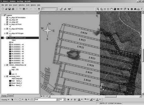
4 (a) (a) (c) Figure 8. Differential INSAR result over the period of (JERS-1, 132 days): (a) Overall result Zoom-in the first Colliery (c) Zoom-in the second Colliery. (c) Figure 9. Differential INSAR result over the period of (JERS-1, 44 days): (a) overall result Zoom-in the first Colliery (c) Zoom-in the second Colliery October 2004 PHOTOGRAMMETRIC ENGINEERING & REMOTE SENSING
 Finish (YYYYMMDD) LW24 19930428 19931210 LW25 19940127 19941027 LW26 19941208 19950805 LW27 19951020 19960624 LW28a 19960801 19961231")
5 TABLE 1. MINING ACTIVITIES AT THE FIRST COLLIERY Longwall Start (YYYYMMDD) Finish (YYYYMMDD) LW LW LW LW LW28a LW28b TABLE 2. MINING ACTIVITIES AT THE SECOND COLLIERY Longwall Start (YYYYMMDD) Finish (YYYYMMDD) however, is almost the same, especially in the second colliery which means the subsiding process can finish in about 44 days directly above the longwall. If the mining methods used at the two collieries are the same, the DINSAR results also imply second colliery is more susceptible to subsidence. From the induced subsidence, it can be deducted that in the first colliery mining is progressing from top to bottom one longwall after another (Figure 8b versus Figure 9b) while mining in each longwall starts at the top-right (northeast) end and finishes at the bottom-left (southwest) end (Figure 8b), even if information about mining activities given in Tables 1 and 2 is not available. In the second colliery, mining is progressing from bottom to top one longwall after another (Figure 8c versus Figure 9c) while the mining direction within each longwall cannot be inferred. With the DINSAR results already in the GIS format, many more map-quality products can be generated. For example, the subsidence can be displayed in 3D; many profiles across the subsidence area can be produced. Figure 10 shows subsidence profiles derived from the JERS-1 DINSAR result for the second colliery. Such precisely georeferenced and well-archived DINSAR results will have a big impact on the mining industry. In the established coal mine fields of eastern Australia, it is becoming increasingly difficult to select underground mine sites which avoid major engineering structures, both on the surface and underground (highways, bridges, buildings, abandoned underground workings). The third colliery, also covered in the radar image, is a representative example, where the surface topography overlying the mine consists of several steep-sided river gorges. The surface is traversed by a freeway which crosses one of the gorges. Consequently, a major surface subsidence monitoring program has been in place for several years, including intensive conventional, GPS and EDM surveying (once or more than once a week) plus real-time monitoring of critical components of the bridge structure. However, current subsidence monitoring techniques are relatively time-consuming and costly. Hence, the monitoring Figure 10. Subsidence profiles derived from the JERS-1 DINSAR result for the second colliery. LW LW LW LW LW is usually constrained to very localized areas, and it is very difficult to monitor any regional deformation induced by underground mining. In addition, even in the localized area, the monitoring points are not usually close enough to assist in understanding the mechanisms involved in ground subsidence. The integrated INSAR-GPS-GIS technique demonstrated here can both be accurate and give a fine spatial characterization of the ground deformation so that it can be used to complement current techniques to measure on a cost-effective basis, on a regular basis, the ground subsidence due to underground mining. Conclusions The importance of using GPS and GIS to assist INSAR data analysis is discussed. An application of the integrated INSAR-GPS-GIS technique to monitoring subsidence due to underground mining southwest of Sydney, has been demonstrated. The integrated technique can be used as a viable operational tool for ground subsidence monitoring to complement current geodetic techniques. Acknowledgments The authors thank Messrs. Yufei Wang and Lijiong Qin of UNSW for assistance in GIS, and the ACRES (the Australian Centre for Remote Sensing) for providing SAR images and satellite programming. References Ge, L., Development and Testing of Augmentations of Continuously-Operating GPS Networks to Improve their Spatial and Temporal Resolution, Ph.D. Dissertation, University of New South Wales, Sydney, NSW 2052, Australia, 230 p. Giordano, A., and F. Hsu, Least Square Estimation with Applications to Digital Signal Processing, New York, Wiley, 412 p. Graham, L.C., Synthetic interferometer radar for topographic mapping, IEEE Transactions on Geoscience and Remote Sensing, 62: Hanssen, R.F., T.M. Weckwerth, H.A. Zebker, and R. Klees, High-resolution water vapor mapping from interferometric radar measurements, Science, 283: PHOTOGRAMMETRIC ENGINEERING & REMOTE SENSING October
In order to obtain a long term monitoring result for the Kilauea Volcano, ALOS PALSAR images taken on Track 287, Frame 38, ascending orbit with 21.5 d
 ALOS PALSAR OBSERVATION OF KILAUEA VOLCANO ACTIVITIES FROM 2006 TO 2009 Zhe Hu, Linlin Ge, Xiaojing Li, Kui Zhang, Alex Hay-Man NG and Chris Rizos Cooperative Research Centre for Spatial Information &
Integration of InSAR and GIS for Monitoring of Subsidence Induced by Block Caving Mining
 Integration of InSAR and GIS for Monitoring of Subsidence Induced by Block Caving Mining Dr. Andrew JAROSZ and Mr. Hani ZAHIRI, Australia Key words: subsidence, block caving, mine deformation, GIS, InSAR,
Radar Remote Sensing: Monitoring Ground Deformations and Geohazards from Space
 Radar Remote Sensing: Monitoring Ground Deformations and Geohazards from Space Xiaoli Ding Department of Land Surveying and Geo-Informatics The Hong Kong Polytechnic University A Question 100 km 100 km
INSAR DEM CALIBRATION FOR TOPOGRAPHIC MAPPING IN EASTERN UGANDA
 INSAR DEM CALIBRATION FOR TOPOGRAPHIC MAPPING IN EASTERN UGANDA Siefko SLOB *, François KERVYN **, Johan LAVREAU **, John ODIDA *** and David KYAGULANYI *** * International Institute for Aerospace Survey
Application of advanced InSAR techniques for the measurement of vertical and horizontal ground motion in longwall minings
 University of Wollongong Research Online Coal Operators' Conference Faculty of Engineering and Information Sciences 2013 Application of advanced InSAR techniques for the measurement of vertical and horizontal
Subsidence-induced fault
 Surveying Monitoring underground coal mining-induced subsidence by Yaobin Sheng, Linlin Ge, Chris Rizos, University of New South Wales, and Yunjia Wang, China University of Mining and Technology This paper
Modeling of Atmospheric Effects on InSAR Measurements With the Method of Stochastic Simulation
 Modeling of Atmospheric Effects on InSAR Measurements With the Method of Stochastic Simulation Z. W. LI, X. L. DING Department of Land Surveying and Geo-Informatics, Hong Kong Polytechnic University, Hung
Two-pass DInSAR uses an interferometric image pair and an external digital elevation model (DEM). Among the two singlelook complex (SLC) images, one i
. Among the two singlelook complex (SLC) images, one i") DIFFERENTIAL RADAR INTERFEROMETRY AND ITS APPLICATION IN MONITORING UNDERGROUND COAL MINING-INDUCED SUBSIDENCE Yaobin Sheng a, b, c, *, Yunjia Wang a, b, Linlin Ge c, Chris Rizos c a Jiangsu Key Laboratory
DIFFERENTIAL RADAR INTERFEROMETRY AND ITS APPLICATION IN MONITORING UNDERGROUND COAL MINING-INDUCED SUBSIDENCE Yaobin Sheng a, b, c, *, Yunjia Wang a, b, Linlin Ge c, Chris Rizos c a Jiangsu Key Laboratory
COAL MINE LAND SUBSIDENCE MONITORING BY USING SPACEBORNE INSAR DATA-A CASE STUDY IN FENGFENG, HEBEI PROVINCE, CHINA
 COAL MINE LAND SUBSIDENCE MONITORING BY USING SPACEBORNE INSAR DATA-A CASE STUDY IN FENGFENG, HEBEI PROVINCE, CHINA Li Cao a, Yuehua Zhang a, Jianguo He a, Guang Liu b,huanyin Yue b, Runfeng Wang a, Linlin
Implementation of Multi-Temporal InSAR to monitor pumping induced land subsidence in Pingtung Plain, Taiwan
 Implementation of Multi-Temporal InSAR to monitor pumping induced land subsidence in Pingtung Plain, Taiwan Presenter: Oswald Advisor: Chuen-Fa Ni Date: March 09, 2017 Literature Review Pingtung Plain
The Potential of High Resolution Satellite Interferometry for Monitoring Enhanced Oil Recovery
 The Potential of High Resolution Satellite Interferometry for Monitoring Enhanced Oil Recovery Urs Wegmüller a Lutz Petrat b Karsten Zimmermann c Issa al Quseimi d 1 Introduction Over the last years land
Real Time Subsidence Monitoring Techniques in Undercity Mining and a Case Study: Zonguldak Undercity Applications-Turkey
 Real Time Subsidence Monitoring Techniques in Undercity Mining and a Case Study: Zonguldak Undercity Hakan AKCIN, Hakan S. KUTOGLU, Turkey Keywords: Undercity mining, subsidence, PALSAR, RADARSAT, GNSS.
Application of differential SAR interferometry for studying eruptive event of 22 July 1998 at Mt. Etna. Abstract
 Application of differential SAR interferometry for studying eruptive event of 22 July 1998 at Mt. Etna Coltelli M. 1, Puglisi G. 1, Guglielmino F. 1, Palano M. 2 1 Istituto Nazionale di Geofisica e Vulcanologia,
Atmospheric Effects on InSAR Measurements in Southern China and Australia: A Comparative Study
 Atmospheric Effects on InSAR Measurements in Southern China and Australia: A Comparative Study X. L. Ding a, *, L. Ge b, Z. W. Li a, C. Rizos b a Dept. of Land Surveying and Geo-Informatics, Hong Kong
Deformation measurement using SAR interferometry: quantitative aspects
 Deformation measurement using SAR interferometry: quantitative aspects Michele Crosetto (1), Erlinda Biescas (1), Ismael Fernández (1), Ivan Torrobella (1), Bruno Crippa (2) (1) (2) Institute of Geomatics,
DIFFERENTIAL INSAR STUDIES IN THE BOREAL FOREST ZONE IN FINLAND
 DIFFERENTIAL INSAR STUDIES IN THE BOREAL FOREST ZONE IN FINLAND Kirsi Karila (1,2), Mika Karjalainen (1), Juha Hyyppä (1) (1) Finnish Geodetic Institute, P.O. Box 15, FIN-02431 Masala, Finland, Email:
High-resolution temporal imaging of. Howard Zebker
 High-resolution temporal imaging of crustal deformation using InSAR Howard Zebker Stanford University InSAR Prehistory SEASAT Topographic Fringes SEASAT Deformation ERS Earthquake Image Accurate imaging
Publication V Finnish Society of Photogrammetry and Remote Sensing (FSPRS)
") Publication V Kirsi Karila, Mika Karjalainen, and Juha Hyyppä. 2005. Urban land subsidence studies in Finland using synthetic aperture radar images and coherent targets. The Photogrammetric Journal of
Publication V Kirsi Karila, Mika Karjalainen, and Juha Hyyppä. 2005. Urban land subsidence studies in Finland using synthetic aperture radar images and coherent targets. The Photogrammetric Journal of
Slow Deformation of Mt. Baekdu Stratovolcano Observed by Satellite Radar Interferometry
 Slow Deformation of Mt. Baekdu Stratovolcano Observed by Satellite Radar Interferometry Sang-Wan Kim and Joong-Sun Won Department of Earth System Sciences, Yonsei University 134 Shinchon-dong, Seodaemun-gu,
ERAD Water vapor observations with SAR, microwave radiometer and GPS: comparison of scaling characteristics
 Proceedings of ERAD (2002): 190 194 c Copernicus GmbH 2002 ERAD 2002 Water vapor observations with SAR, microwave radiometer and GPS: comparison of scaling characteristics D. N. Moisseev 1, R. F. Hanssen
Luyi Sun & Jan-Peter Muller, Imaging Group, Mullard Space Science Laboratory, University College London
 Evaluation of the use of the sub-pixel Offset Tracking method with conventional dinsar techniques to monitor landslides in densely vegetated terrain in the Three Gorges Region, China Luyi Sun & Jan-Peter
Interferometric SAR analysis for Characterizing Surface Changes of an Active Volcano using Open Source Software
 Interferometric SAR analysis for Characterizing Surface Changes of an Active Volcano using Open Source Software Asep SAEPULOH1, Katsuaki KOIKE1, Makoto OMURA2 1 Department of Life and Environmental Sciences,
MODELING INTERFEROGRAM STACKS FOR SENTINEL - 1
 MODELING INTERFEROGRAM STACKS FOR SENTINEL - 1 Fabio Rocca (1) (1) Politecnico di Milano, Via Ponzio 34/5, 20133 Milano, Italy, Email: rocca@elet.polimi.it ABSTRACT The dispersion of the optimal estimate
MAPPING DEFORMATION OF MAN-MADE LINEAR FEATURES USING DINSAR TECHNIQUE
 MAPPING DEFORMATION OF MAN-MADE LINEAR FEATURES USING DINSAR TECHNIQUE H. Wu a, *, Y. Zhang a, J. Zhang a, X. Chen b a Key Laboratory of Mapping from Space of State Bureau of Surveying and Mapping, Chinese
Detecting Illegal Mining Activities Using DInSAR
 Detecting Illegal Mining Activities Using DInSAR H.S. Kutoglu 1, H. Akcin 1, T. Deguchi 2, H. Kemaldere 1 1 Zonguldak Karaelmas Universitesi,, Türkiye; T 2 ERSDAC, Japan 17.06.2008 TS4D_3031 Study Area
ERS-ENVISAT CROSS-INTERFEROMETRY SIGNATURES OVER DESERTS. Urs Wegmüller, Maurizio Santoro and Christian Mätzler
 ERS-ENVISAT CROSS-INTERFEROMETRY SIGNATURES OVER DESERTS Urs Wegmüller, Maurizio Santoro and Christian Mätzler Gamma Remote Sensing AG, Worbstrasse 225, CH-3073 Gümligen, Switzerland, http://www.gamma-rs.ch,
THREE DIMENSIONAL DETECTION OF VOLCANIC DEPOSIT ON MOUNT MAYON USING SAR INTERFEROMETRY
 ABSTRACT THREE DIMENSIONAL DETECTION OF VOLCANIC DEPOSIT ON MOUNT MAYON USING SAR INTERFEROMETRY Francis X.J. Canisius, Kiyoshi Honda, Mitsuharu Tokunaga and Shunji Murai Space Technology Application and
ERS Track 98 SAR Data and InSAR Pairs Used in the Analysis
 ERS Track 98 SAR Data and InSAR Pairs Used in the Analysis Date 1 Date 2 Date 1 Date 2 Date 1 Date 2 Date 1 Date 2 7/17/1992 6/19/2000 7/17/1992 7/2/1993 9/10/1993 10/28/1996 9/3/1995 10/18/1999 9/25/1992
Ground surface deformation of L Aquila. earthquake revealed by InSAR time series
 Ground surface deformation of L Aquila earthquake revealed by InSAR time series Reporter: Xiangang Meng Institution: First Crust Monitoring and Application Center, CEA Address: 7 Naihuo Road, Hedong District
INSAR ATMOSPHERIC DELAY MIGITIGATION BY GPS; CASE STUDY IZMIT EARTQUAKE INTERFEROGRAMS
 INSAR ATMOSPHERIC DELAY MIGITIGATION BY GPS; CASE STUDY IZMIT EARTQUAKE INTERFEROGRAMS M.U. Altın a, *, E. Tari a, L. Ge b a ITU, Civil Engineering Faculty, 80626 Maslak Istanbul, Turkey (altinm, tari)@itu.edu.tr
DEM GENERATION AND ANALYSIS ON RUGGED TERRAIN USING ENVISAT/ASAR ENVISAT/ASAR MULTI-ANGLE INSAR DATA
 DEM GENERATION AND ANALYSIS ON RUGGED TERRAIN USING ENVISAT/ASAR ENVISAT/ASAR MULTI-ANGLE INSAR DATA Li xinwu Guo Huadong Li Zhen State Key Laboratory of Remote Sensing Science, Institute of Remote Sensing
The Tohoku Earthquake 2011 Case.
 Wide Area Deformation map generation with TerraSAR-X Data. The Tohoku Earthquake 2011 Case. N. Yague-Martinez (1), C. Minet (2), M. Eineder (2), B. Schättler (2) (1) Starlab, Spain (2) Remote Sensing Technology
TEMPORAL VARIABILITY OF ICE FLOW ON HOFSJÖKULL, ICELAND, OBSERVED BY ERS SAR INTERFEROMETRY
 TEMPORAL VARIABILITY OF ICE FLOW ON HOFSJÖKULL, ICELAND, OBSERVED BY ERS SAR INTERFEROMETRY Florian Müller (1), Helmut Rott (2) (1) ENVEO IT, Environmental Earth Observation GmbH, Technikerstrasse 21a,
Analysis of mining deformations based on PSInSAR technique case study of the Walbrzych coal mines (Poland)
") Analysis of mining deformations based on PSInSAR technique case study of the Walbrzych coal mines (Poland) Dr. Jan Blachowski, Dr. Wojciech Milczarek Faculty of Geoengineering, Mining and Geology, Wroclaw
Analysis of mining deformations based on PSInSAR technique case study of the Walbrzych coal mines (Poland) Dr. Jan Blachowski, Dr. Wojciech Milczarek Faculty of Geoengineering, Mining and Geology, Wroclaw
Snow Water Equivalent (SWE) of dry snow derived from InSAR -theory and results from ERS Tandem SAR data
 of dry snow derived from InSAR -theory and results from ERS Tandem SAR data") Snow Water Equivalent (SWE) of dry snow derived from InSAR -theory and results from ERS Tandem SAR data Tore Guneriussen, Kjell Arild Høgda, Harald Johnsen and Inge Lauknes NORUT IT Ltd., Tromsø Science
Snow Water Equivalent (SWE) of dry snow derived from InSAR -theory and results from ERS Tandem SAR data Tore Guneriussen, Kjell Arild Høgda, Harald Johnsen and Inge Lauknes NORUT IT Ltd., Tromsø Science
P079 First Results from Spaceborne Radar Interferometry for the Study of Ground Displacements in Urban Areas SUMMARY
 P079 First Results from Spaceborne Radar Interferometry for the Study of Ground Displacements in Urban Areas C.M. Crosetto (Instituto de Geomatica), C.A. Casas (University of Barcelona), R.G. Ranieri (University
DEM REGISTRATION, ALIGNMENT AND EVALUATION FOR SAR INTERFEROMETRY
 DEM REGISTRATION, ALIGNMENT AND EVALUATION FOR SAR INTERFEROMETRY Zhengxiao Li a, James Bethel b a ERDAS, Inc. (Leica Geosystems Geospatial Imaging), 551 Peachtree Corners Circle, Norcross, Georgia 392,
Interferometers of synthetic aperture radar (InSAR) relevance in generation of digital elevation model (DEM) for real world solutions
 relevance in generation of digital elevation model (DEM) for real world solutions") ISSN: 2455-4227 Impact Factor: RJIF 5.12 www.allsciencejournal.com Volume 2; Issue 5; September 2017; Page No. 143-148 Interferometers of synthetic aperture radar (InSAR) relevance in generation of digital
ISSN: 2455-4227 Impact Factor: RJIF 5.12 www.allsciencejournal.com Volume 2; Issue 5; September 2017; Page No. 143-148 Interferometers of synthetic aperture radar (InSAR) relevance in generation of digital
SAR interferometry Status and future directions. Rüdiger Gens
 SAR interferometry Status and future directions Rüdiger Gens Polarimetric InSAR Polarimetric InSAR InSAR - Status and future directions sensitivity to changes in surface scattering, even in the presence
MONITORING OF GLACIAL CHANGE IN THE HEAD OF THE YANGTZE RIVER FROM 1997 TO 2007 USING INSAR TECHNIQUE
 MONITORING OF GLACIAL CHANGE IN THE HEAD OF THE YANGTZE RIVER FROM 1997 TO 2007 USING INSAR TECHNIQUE Hong an Wu a, *, Yonghong Zhang a, Jixian Zhang a, Zhong Lu b, Weifan Zhong a a Chinese Academy of
RADAR Remote Sensing Application Examples
 RADAR Remote Sensing Application Examples! All-weather capability: Microwave penetrates clouds! Construction of short-interval time series through cloud cover - crop-growth cycle! Roughness - Land cover,
The PaTrop Experiment
 Improved estimation of the tropospheric delay component in GNSS and InSAR measurements in the Western Corinth Gulf (Greece), by the use of a highresolution meteorological model: The PaTrop Experiment N.
ALOS PI Symposium 2009, 9-13 Nov 2009 Hawaii MOTION MONITORING FOR ETNA USING ALOS PALSAR TIME SERIES
 ALOS PI Symposium 2009, 9-13 Nov 2009 Hawaii ALOS Data Nodes: ALOS RA-094 and RA-175 (JAXA) MOTION MONITORING FOR ETNA USING ALOS PALSAR TIME SERIES Urs Wegmüller, Charles Werner and Maurizio Santoro Gamma
APPLICABILITY OF PSINSAR FOR BUILDING HAZARD IDENTIFICATION
 APPLICABILITY OF PSINSAR FOR BUILDING HAZARD IDENTIFICATION. STUDY OF THE 29 JANUARY 2006 KATOWICE EXHIBITION HALL COLLAPSE AND THE 24 FEBRUARY 2006 MOSCOW BASMANNY MARKET COLLAPSE Zbigniew Perski (1),
MEASURING VOLCANIC DEFORMATION AT UNIMAK ISLAND FROM 2003 TO 2010 USING
 MEASURING VOLCANIC DEFORMATION AT UNIMAK ISLAND FROM 2003 TO 2010 USING WEATHER MODEL-ASSISTED TIME SERIES INSAR Gong, W. a, Meyer, F. J. a, Lee, C. W. b, Lu, Z. c, Freymueller, J a. a. Geophysical Institute,
Urban land and infrastructure deformation monitoring by satellite radar interferometry
 Urban land and infrastructure deformation monitoring by satellite radar interferometry Lei Zhang and Xiaoli Ding Department of Land Surveying and Geo-Informatics (LSGI) The Hong Kong Polytechnic University
Innovative InSAR approach to tackle strong nonlinear time lapse ground motion
 FMGM 2015 PM Dight (ed.) 2015 Australian Centre for Geomechanics, Perth, ISBN 978-0-9924810-2-5 https://papers.acg.uwa.edu.au/p/1508_15_salva/ Innovative InSAR approach to tackle strong nonlinear time
ERS-ENVISAT Cross-interferometry for Coastal DEM Construction
 ERS-ENVISAT Cross-interferometry for Coastal DEM Construction Sang-Hoon Hong and Joong-Sun Won Department of Earth System Sciences, Yonsei University, 134 Shinchon-dong, Seodaemun-gu, 120-749, Seoul, Korea
3D temporal evolution of displacements recorded on Mt. Etna from the 2007 to 2010 through the SISTEM method
 3D temporal evolution of displacements recorded on Mt. Etna from the 2007 to 2010 through the SISTEM method Bonforte A., Guglielmino F.,, Puglisi G. INGV Istituto Nazionale di Gofisica e vulcanologia Osservatorio
Mitigation of Atmospheric Water-vapour Effects on Spaceborne Interferometric SAR Imaging through the MM5 Numerical Model
 PIERS ONLINE, VOL. 6, NO. 3, 2010 262 Mitigation of Atmospheric Water-vapour Effects on Spaceborne Interferometric SAR Imaging through the MM5 Numerical Model D. Perissin 1, E. Pichelli 2, R. Ferretti
PERSISTENT SCATTERER SAR INTERFEROMETRY APPLICATIONS ON LANDSLIDES IN CARPATHIANS (SOUTHERN POLAND)
") Acta Geodyn. Geomater., Vol. 7, No. 3 (159), 1 7, 2010 PERSISTENT SCATTERER SAR INTERFEROMETRY APPLICATIONS ON LANDSLIDES IN CARPATHIANS (SOUTHERN POLAND) Zbigniew PERSKI 1) *, Tomasz WOJCIECHOWSKI 1)
Acta Geodyn. Geomater., Vol. 7, No. 3 (159), 1 7, 2010 PERSISTENT SCATTERER SAR INTERFEROMETRY APPLICATIONS ON LANDSLIDES IN CARPATHIANS (SOUTHERN POLAND) Zbigniew PERSKI 1) *, Tomasz WOJCIECHOWSKI 1)
Ground deformation monitoring in Pearl River Delta region with Stacking D-InSAR technique
 Ground deformation monitoring in Pearl River Delta region with Stacking DInSAR technique Zhao Qing*, LIN Hui, JIANG Liming Institute of Space and Earth Information Science, Room 615, Esther Lee Building,
Journal of Geodynamics
 Journal of Geodynamics 49 (2010) 161 170 Contents lists available at ScienceDirect Journal of Geodynamics journal homepage: http://www.elsevier.com/locate/jog Recent advances on surface ground deformation
Observation of Surface Displacements on Glaciers, Sea Ice, and Ice Shelves Around Canisteo Peninsula, West Antarctica Using 4-Pass DInSAR
 4 hyangsun@kangwon.ac.kr, hoonyol@kangwon.ac.kr Observation of Surface Displacements on Glaciers, Sea Ice, and Ice Shelves Around Canisteo Peninsula, West Antarctica Using 4-Pass DInSAR Hyangsun Han and
The financial and communal impact of a catastrophe instantiated by. volcanoes endlessly impact on lives and damage expensive infrastructure every
 Chapter 1 Introduction The financial and communal impact of a catastrophe instantiated by geophysical activity is significant. Landslides, subsidence, earthquakes and volcanoes endlessly impact on lives
Lauren Jacob May 6, Tectonics of the Northern Menderes Massif: The Simav Detachment and its relationship to three granite plutons
 Lauren Jacob May 6, 2010 Tectonics of the Northern Menderes Massif: The Simav Detachment and its relationship to three granite plutons I. Introduction: Purpose: While reading through the literature regarding
Monitoring Mining Induced Subsidences Using GPS and InSAR
 Hakan. AKÇIN, Turkey, Tomonori. DEGUCCI, Japan and Hakan.S. KUTOĞLU, Turkey Keywords: Mining, subsidence, GPS, InSAR, JERS-1 SAR, RADARSAT SUMMARY Underground mining causes subsidence effect on the earth
Generating an InSAR DEM using ASF software tools. Rüdiger Gens
 Generating an InSAR DEM using ASF software tools Rüdiger Gens 2 Outline! AKDEM production system! SAR interferometric processing chain " general setup " examples 3 AKDEM production system! driver program
I. Permission to publish. II. Offprint order. III. Copyright Transfer Statement (sign only if not submitted previously) Dear Maria Muskalla,
 Dear Maria Muskalla,") Fax to: +49622148768528 Maria Muskalla Springer Heidelberg, 69121 Heidelberg From: Re: Authors: GPS Solutions DOI 10.1007/s10291-004-0099-1 Tropospheric corrections to SAR interferometry from GPS observations
Fax to: +49622148768528 Maria Muskalla Springer Heidelberg, 69121 Heidelberg From: Re: Authors: GPS Solutions DOI 10.1007/s10291-004-0099-1 Tropospheric corrections to SAR interferometry from GPS observations
MEASUREMENT OF SURFACE DISPLACEMENT CAUSED BY UNDERGROUND NUCLEAR EXPLOSIONS BY DIFFERENTIAL SAR INTERFEROMETRY
 MEASUREMENT OF SURFACE DISPLACEMENT CAUSED BY UNDERGROUND NUCLEAR EXPLOSIONS BY DIFFERENTIAL SAR INTERFEROMETRY X. Cong a, KH. Gutjahr b, J. Schlittenhardt a, U. Soergel c, a Bundesanstalt für Geowissenschaften
GEOGRAPHICAL DATABASES FOR THE USE OF RADIO NETWORK PLANNING
 GEOGRAPHICAL DATABASES FOR THE USE OF RADIO NETWORK PLANNING Tommi Turkka and Jaana Mäkelä Geodata Oy / Sanoma WSOY Corporation Konalantie 6-8 B FIN-00370 Helsinki tommi.turkka@geodata.fi jaana.makela@geodata.fi
InSAR measurements of volcanic deformation at Etna forward modelling of atmospheric errors for interferogram correction
 InSAR measurements of volcanic deformation at Etna forward modelling of atmospheric errors for interferogram correction Rachel Holley, Geoff Wadge, Min Zhu Environmental Systems Science Centre, University
VALIDATION OF THE PERMANENT SCATTERERS TECHNIQUE IN URBAN AREAS
 VALIDATION OF THE PERMANENT SCATTERERS TECHNIQUE IN URBAN AREAS Alessandro Ferretti, Claudio Prati, Fabio Rocca, Carlo Colesanti Dipartimento di Elettonica e Informazione Politecnico di Milano Piazza L.
Inflation of the Aira Caldera (Japan) detected over Kokubu urban area using SAR interferometry ERS data
 detected over Kokubu urban area using SAR interferometry ERS data") Inflation of the Aira Caldera (Japan) detected over Kokubu urban area using SAR interferometry ERS data D. Remy, S. Bonvalot, M. Murakami, P. Briole, S. Okuyama To cite this version: D. Remy, S. Bonvalot,
Inflation of the Aira Caldera (Japan) detected over Kokubu urban area using SAR interferometry ERS data D. Remy, S. Bonvalot, M. Murakami, P. Briole, S. Okuyama To cite this version: D. Remy, S. Bonvalot,
SAR Data Analysis: An Useful Tool for Urban Areas Applications
 SAR Data Analysis: An Useful Tool for Urban Areas Applications M. Ferri, A. Fanelli, A. Siciliano, A. Vitale Dipartimento di Scienza e Ingegneria dello Spazio Luigi G. Napolitano Università degli Studi
InSAR tropospheric delay mitigation by GPS observations: A case study in Tokyo area
 ARTICLE IN PRESS Journal of Atmospheric and Solar-Terrestrial Physics 68 (2006) 629 638 www.elsevier.com/locate/jastp InSAR tropospheric delay mitigation by GPS observations: A case study in Tokyo area
J. Manuel Delgado (1,2), Roberto Cuccu (1), Giancarlo Rivolta (1)
, Roberto Cuccu (1), Giancarlo Rivolta (1)") MONITORING GROUND DEFORMATION USING PERSISTENT SCATTERS INTERFEROMETRY (PSI) AND SMALL BASELINES (SBAS) TECHNIQUES INTEGRATED IN THE ESA RSS SERVICE: THE CASE STUDY OF VALENCIA, ROME AND SOUTH SARDINIA
MONITORING GROUND DEFORMATION USING PERSISTENT SCATTERS INTERFEROMETRY (PSI) AND SMALL BASELINES (SBAS) TECHNIQUES INTEGRATED IN THE ESA RSS SERVICE: THE CASE STUDY OF VALENCIA, ROME AND SOUTH SARDINIA
MERIS and OSCAR: Online Services for Correcting Atmosphere in Radar
 National Aeronautics and Space Administration MERIS and OSCAR: Online Services for Correcting Atmosphere in Radar Eric Fielding and Evan Fishbein Jet Propulsion Laboratory, California Inst. of Tech. Zhenhong
Measuring rock glacier surface deformation using SAR interferometry
 Permafrost, Phillips, Springman & Arenson (eds) 2003 Swets & Zeitlinger, Lisse, ISBN 90 5809 582 7 Measuring rock glacier surface deformation using SAR interferometry L.W. Kenyi Institute for Digital Image
ANALYSIS OF VERTICAL MOVEMENTS DETECTED BY RADAR INTERFEROMETRY IN URBAN AREAS
 10TH CZECH-POLISH WORKSHOP ON RECENT GEODYNAMICS OF THE SUDETEN AND ADJACENT AREAS Szklarska Poręba, Poland, November 5 7, 2009 ANALYSIS OF VERTICAL MOVEMENTS DETECTED BY RADAR INTERFEROMETRY IN URBAN
27th Seismic Research Review: Ground-Based Nuclear Explosion Monitoring Technologies
 GROUND TRUTH LOCATIONS USING SYNERGY BETWEEN REMOTE SENSING AND SEISMIC METHODS-APPLICATION TO CHINESE AND NORTH AFRICAN EARTHQUAKES C. K. Saikia 1, H. K. Thio 2, D. V. Helmberger 2, G. Ichinose 1, and
12/26/2012. Geographic Information Systems * * * * GIS (... yrezaei
 ( - Geographic Information Systems ( ( 1 2 3 Information System Data base DB IS IS DB (Knowledge ( ( (System (Information System - (Georefrence Analysis Data + Knowledge ======== Information 4 5 ( < 10%
Constructing high-resolution, absolute maps of atmospheric water vapor by combining InSAR and GNSS observations
 Constructing high-resolution, absolute maps of atmospheric water vapor by combining InSAR and GNSS observations Fadwa Alshawaf, Stefan Hinz, Michael Mayer, Franz J. Meyer fadwa.alshawaf@kit.edu INSTITUTE
CHAPTER-7 INTERFEROMETRIC ANALYSIS OF SPACEBORNE ENVISAT-ASAR DATA FOR VEGETATION CLASSIFICATION
 147 CHAPTER-7 INTERFEROMETRIC ANALYSIS OF SPACEBORNE ENVISAT-ASAR DATA FOR VEGETATION CLASSIFICATION 7.1 INTRODUCTION: Interferometric synthetic aperture radar (InSAR) is a rapidly evolving SAR remote
Application of InSAR for Monitoring Deformations at the Kiirunavaara Mine
 Application of InSAR for Monitoring Deformations at the Kiirunavaara Mine Karola Mäkitaavola Britt-Mari Stöckel Jonny Sjöberg Stephen Hobbs Jonas Ekman Michael Henschel Anura Wickramanyake SUBLEVEL CAVING
THE FEASIBILITY AND APPLICATION OF PSI TO DETECT A RANGE OF GROUND AND STRUCTURE MOTION PHENOMENA.
 THE FEASIBILITY AND APPLICATION OF PSI TO DETECT A RANGE OF GROUND AND STRUCTURE MOTION PHENOMENA. Rachel Holley, InSAR Surveying Consultant InSAR Surveying Team Fugro NPA Satellite Mapping Introduction
DETECTING ICE MOTION IN GROVE MOUNTAINS, EAST ANTARCTICA WITH ALOS/PALSAR AND ENVISAT/ASAR DATA
 DETECTING ICE MOTION IN GROVE MOUNTAINS, EAST ANTARCTICA WITH ALOS/PALSAR AND ENVISAT/ASAR DATA TIAN Xin (1), LIAO Mingsheng (1), ZHOU Chunxia (2), ZHOU Yu (3) (1) State Key Laboratory of Information Engineering
Is ISAR Interferometry Able to Detect Slope Deformations of Open Pit Mines?
 Andrew Jarosz Page 1 29/07/2002 Is ISAR Interferometry Able to Detect Slope Deformations of Open Pit Mines? Andrew Jarosz and Luke Shepherd Curtin University, Western Australian School of Mines, Mine Surveying
MONITORING SUBSURFACE COAL FIRES USING SATELLITE-BASED OBSERVATIONS
 MONITORING SUBSURFACE COAL FIRES USING SATELLITE-BASED OBSERVATIONS Tajdarul H Syed Department of Applied Geology, Indian School of Mines, Dhanbad, India. CANEUS SSTDM 2014 SSTDM-2014 IISc, Bangalore Jharia
Mining Science and Technology (China)
") Mining Science and Technology (China) 21 (2011) 781 786 Contents lists available at SciVerse ScienceDirect Mining Science and Technology (China) journal homepage: www.elsevier.com/locate/mstc Use of SAR
Mining Science and Technology (China) 21 (2011) 781 786 Contents lists available at SciVerse ScienceDirect Mining Science and Technology (China) journal homepage: www.elsevier.com/locate/mstc Use of SAR
Evaluation of spatial moisture distribution during CLARA 96 using spaceborne radar interferometry
 Evaluation of spatial moisture distribution during CLARA 96 using spaceborne radar interferometry Ramon F. Hanssen and Tammy M. Weckwerth DEOS, Delft Institute for Earth-Oriented Space, Delft University
Advanced interpretation of land subsidence by validating multiinterferometric SAR data: the case study of Anthemountas basin (Northern Greece)
") Revision of paper Advanced interpretation of land subsidence by validating multiinterferometric SAR data: the case study of Anthemountas basin (Northern Greece) By Raspini et al. General comments This
Revision of paper Advanced interpretation of land subsidence by validating multiinterferometric SAR data: the case study of Anthemountas basin (Northern Greece) By Raspini et al. General comments This
ATMOSPHERIC ERROR, PHASE TREND AND DECORRELATION NOISE IN TERRASAR-X DIFFERENTIAL INTERFEROGRAMS
 ATMOSPHERIC ERROR, PHASE TREND AND DECORRELATION NOISE IN TERRASAR-X DIFFERENTIAL INTERFEROGRAMS Steffen Knospe () () Institute of Geotechnical Engineering and Mine Surveying, Clausthal University of Technology,
3-Dimension Deformation Mapping from InSAR & Multiaperture. Hyung-Sup Jung The Univ. of Seoul, Korea Zhong Lu U.S. Geological Survey, U.S.A.
 3-Dimension Deformation Mapping from InSAR & Multiaperture InSAR Hyung-Sup Jung The Univ. of Seoul, Korea Zhong Lu U.S. Geological Survey, U.S.A. Outline Introduction to multiple-aperture InSAR (MAI) 3-D
NOTES AND CORRESPONDENCE Segmented Faulting Process of Chelungpu Thrust: Implication of SAR Interferograms
 , Vol. 14, No.2, 241-247, June 2003 NOTES AND CORRESPONDENCE Segmented Faulting Process of Chelungpu Thrust: Implication of SAR Interferograms Chien-Chih Chen 1,*, Chung-Pai Chang 2, and Kun-Shan Chen
PERSISTENT SCATTERER INTERFEROMETRY: POTENTIAL AND LIMITS
 PERSISTENT SCATTERER INTERFEROMETRY: POTENTIAL AND LIMITS M. Crosetto a, O. Monserrat a, A. Jungner, B. Crippa b a Institute of Geomatics, Av. del Canal Olímpic, s/n, Castelldefels, E-08860, Spain (michele.crosetto,
REMOTE SENSING AND GEOSPATIAL APPLICATIONS FOR WATERSHED DELINEATION
 REMOTE SENSING AND GEOSPATIAL APPLICATIONS FOR WATERSHED DELINEATION Gaurav Savant (gaurav@engr.msstate.edu) Research Assistant, Department of Civil Engineering, Lei Wang (lw4@ra.msstate.edu) Research
Lecture 9: Reference Maps & Aerial Photography
 Lecture 9: Reference Maps & Aerial Photography I. Overview of Reference and Topographic Maps There are two basic types of maps? Reference Maps - General purpose maps & Thematic Maps - maps made for a specific
Zenith delay [mm] Time [min]
![Zenith delay [mm] Time [min]](/thumbs/72/66821223.jpg "Zenith delay [mm] Time [min]") GPS Nieuwsbrief, (1), 2., Nov. 2. Cross-Validation of tropospheric delay variability observed by GPS and SAR interferometry Andre van der Hoeven, Ramon Hanssen, Boudewijn Ambrosius Delft Institute for
GPS Nieuwsbrief, (1), 2., Nov. 2. Cross-Validation of tropospheric delay variability observed by GPS and SAR interferometry Andre van der Hoeven, Ramon Hanssen, Boudewijn Ambrosius Delft Institute for
THE USE OF DIFFERENT REMOTE SENSING TECHNIQUES FOR LANDSLIDE CHARACTERIZATION
 THE USE OF DIFFERENT REMOTE SENSING TECHNIQUES FOR LANDSLIDE CHARACTERIZATION Ph.D. candidate: ANNA DE AGOSTINI Tutor: Dr. M. FLORIS Cycle: XXVI Abstract The aim of my research is to investigate the potential
Yrd. Doç. Dr. Saygın ABDİKAN Öğretim Yılı Güz Dönemi
 Yabancı Dil III (YDL285) Introduction to Geomatics Yrd. Doç. Dr. Saygın ABDİKAN 2017-2018 Öğretim Yılı Güz Dönemi 1 géomatique Geo (Earth) + informatics Geodesy + Geoinformatics Geomatics: The mathematics
Atmospheric Water Vapor Effect on GNSS Signals and InSAR Data
 Atmospheric Water Vapor Effect on GNSS Signals and InSAR Data Basic Concept and Preliminary Results F. Alshawaf 1, S. Hinz 1, A. Thiele 1 T. Fuhrmann 2, B. Heck 2, A. Knöpfler 2, X. Luo 2, M. Mayer 2,
Available online at GHGT-9. Detection of surface deformation related with CO 2 injection by DInSAR at In Salah, Algeria
 Available online at www.sciencedirect.com Energy Procedia 100 (2009) (2008) 2177 2184 000 000 Energy Procedia www.elsevier.com/locate/procedia www.elsevier.com/locate/xxx GHGT-9 Detection of surface deformation
GEOMORPHOLOGICAL MAPPING WITH RESPECT TO AMPLITUDE, COHERENCEAND PHASE INFORMATION OF ERS SAR TANDEM PAIR
 GEOMORPHOLOGICAL MAPPING WITH RESPECT TO AMPLITUDE, COHERENCEAND PHASE INFORMATION OF ERS SAR TANDEM PAIR AUNG LWIN Assistant Researcher Remote Sensing Department Mandalay Technological University, Myanmar
Geochemistry, Geophysics, Geosystems. Supporting Information for
 1 2 3 4 5 6 7 8 Geochemistry, Geophysics, Geosystems Supporting Information for Volcano Deformation Survey over the Northern and Central Andes with ALOS InSAR Time Series Anieri M. Morales Rivera 1, Falk
Early Warning and Earthquake Monitoring Using New Earth Observation Radar Techniques
 Early Warning and Earthquake Monitoring Using New Earth Observation Radar Techniques APSCO Third International Symposium on Earth Quake Monitoring and Early Warning by Using Space Technology Beijing, China
Land subsidence at the Kujukuri Plain in Chiba Prefecture, Japan: evaluation and monitoring environmental impacts
 Land Subsidence, Associated Hazards and the Role of Natural Resources Development (Proceedings of EISOLS 2010, Querétaro, Mexico, 17 22 October 2010). IAHS Publ. 339, 2010. 293 Land subsidence at the Kujukuri
Part : General Situation of Surveying and Mapping. The Development of Surveying and Mapping in China. The contents
 The Development of Surveying and Mapping in China Dr. Ping Xiao China.P.R The contents Part : General Situation of Surveying and Mapping 1. The legal systems of surveying and mapping 2. The technologies
Supplementary information. Analytical Techniques and Measurement Uncertainty
 Supplementary information Analytical Techniques and Measurement Uncertainty Interferomeric SAR (InSAR) allows measurement of millimetre-level surface displacements, including land subsidence, in the radar
Keywords: ASTER, SRTM, Digital Elevation Model, GPS-Levelling data, Validation.
 www.sgem.org ACCURACY ASSESSMENT OF ASTER AND SRTM DIGITAL ELEVATION MODELS: A CASE STUDY IN TURKEY H. Tugba Arli IL 1 Dr. R. Alpay ABBAK 2 1 Ministry of Health - Turkey 2 Selcuk University - Turkey ABSTRACT