Yrd. Doç. Dr. Saygın ABDİKAN Öğretim Yılı Güz Dönemi
|
|
|
- Ilene Foster
- 6 years ago
- Views:
Transcription

1 Yabancı Dil III (YDL285) Introduction to Geomatics Yrd. Doç. Dr. Saygın ABDİKAN Öğretim Yılı Güz Dönemi 1
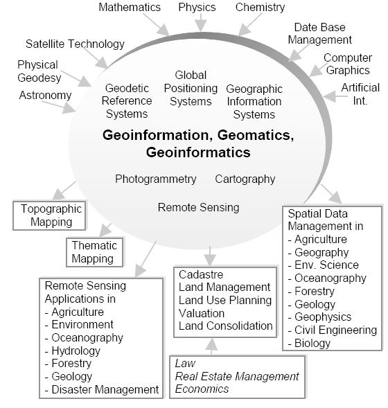
2 géomatique Geo (Earth) + informatics Geodesy + Geoinformatics Geomatics: The mathematics of the earth; the science of the collection, analysis, and interpretation of data, especially instrumental data, relating to the earth's surface. Oxford Dictionary 2
3 What is Geomatics? Geomatics Engineering is a rapidly developing discipline that focuses on spatial information Geomatics Engineers work with state of the art technology Geodesy Digital photogrammetry Remote sensing Digital cartography Geographic information systems Spatial analysis & modeling Global positioning systems Computer vision, digital image processing 3
4 Geomatics Engineering is developing the science and creating new uses for the technology developed The word geomatics describes the integrated approach of Measurement Analysis Management Storage and Display of spatial Earth related data in digital form It can be said that geomatics is based on spatial information technology 4
5 Besides it also involves Pyhsical Social Biological Economical Business sciences with respect to mathematical and logical relatioships Ipbuker,
6 6
7 The graduates of Geomatics Engineering work in a range of organizations Specialist land, air and offshore mapping companies, Central and local government agencies, Cartographic publishers, Suppliers of computer-based mapping technology and GIS companies, Civil engineering contractors, Oil exploration multinationals and geophysical consultants. 7
8 The questions that investigated by geomatics engineering (surveying engineering) How do satellite navigation systems work? How do we know the Earth s continents move? If we look at the Earth from space what can we see? How do we make maps of the land and sea? 8
9 What do geomatics engineers use? Hardware: Computers and networks Surveying and geodetic instruments Photogrammetric workstations Visualization tools Software: GIS Digital image processing Satellite positioning and GPS 9

10 What do we use? 10
11 High precision geodetic measurements and use advanced methods of processing Application of sensor technology in spatial data acquisition Implementing GIS solutions in urban cadaster 3D space modeling through modern mapping techniques Monitoring and probabilistic analyzing of environment systems Use satellite, laser and 3D technology to create the maps of tomorrow (prediction) 11
12 Surveying It is the science, art, and technology of determining the relative positions of points above, on or beneath the Earth s surface Geomatics embraces the traditional areas of surveying and mapping Topographic surveying Geodesy Cadastrial surveying Photogrammetry Hydrography 12
 https://www.")
13 Geodesy Traditionally it is the shape, size, and the gravity field of the Earth. Nowadays: Monitoring the solid Earth (displacement, subsidence or deformation due to tectonic or other natural phenomena as well as human activity. (?) 13
14 monitoring variations in the liquid Earth (sea-level rise, ice sheets); monitoring variations in the Earth's rotation (polar motion, the length of the day); monitoring the atmosphere with satellite geodetic techniques (ionosphere and troposphere composition and physical state); monitoring the temporal variations in the Earth's gravity field; determining satellite orbits (including Earth observation and navigation satellites); determining positions - and their changes with time - of points on or above the surface of the Earth 14
15 GNSS Global Positioning System - GPS A navigation system developed and maintained by the U.S Dept. of Defense Satellite based system Consists of 3 segments: Space Control Users 15
16 Space segment: GPS constellation 31 satellites currently operational in orbit Orbital period 12 hours (satellites pass over the same locations or almost the same locations every day.) Each satellite circles the Earth twice a day. Four satellites must be in view of the receiver for it to compute four unknown quantities (three position coordinates and clock deviation from satellite time). 16


17 Applications of GPS Map projections and geodetic datum Ground motion Geohazards and the deformation of the Earth Seismic and gravitational survey Precise positioning in agriculture, environment, marine, rail and road Create maps and verify the boundaries of property 17
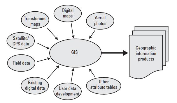
18 GIS A geographic information system (GIS) is a computer system designed to capture, store, manipulate, analyze, manage, and present all types of spatial or geographical data. Database technology can manage multidimensional data 18

19 GIS A digital model of the real world 19
20 20

21 GIS application examples Land suitability analysis Prediction modeling Time series analysis Change detection Digital landscape rschapter/ 21
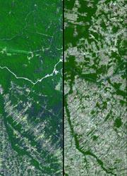
22 Before and after imagery of Amazon deforestation 22

23 Digital image & mapping Pixel Digital Number 23
24 Photogrammetry Photogrammetry is the art and science of making accurate measurements by means of aerial photography: Analog photogrammetry (using films: hardcopy photos) Analytical photogrammetry Digital photogrammetry (digital images) 24


25 Flight planning Ground Control Points - GCP Equipment Aerial cameras - Orthophoto - Stereo model - Digital elevation model


26 Remote Sensing Collection of data without being in physical contact Human eye 26

27 Electromagnetic spectrum Visible & infrared bands & thermal Microwave remote sensing 27
28 Remote Sensing Satellite imagery Sensor types Passive / active systems Lidar (Light detection and ranging) Radar (Radio detection and ranging) Multispectral / Hyperspectral imagery Bathymetry Thermal imagery 28

29 Remote Sensing applications Land use/cover maps

30 Temporal analysis Change detection Fusun Balik Sanli & Filiz Bektas Balcik & Cigdem Goksel,2007, Environ Monit Assess Defining temporal spatial patterns of mega city Istanbul to see the impacts of increasing population 30


31 Global monitoring CarbonTracker CO2 weather for June-July, Warm colors show high atmospheric CO2 concentrations, and cool colors show low concentrations. The soil moisture conditions around the planet were like in August 2013: dry areas are represented in the brown scale, while wetter areas are in blue and green. 31
 crop yield estimation (ürün verim")
32 Vegetation crop (ekin/ürün) type classification crop condition assessment (crop monitoring, damage assessment) crop yield estimation (ürün verim tahmini) 32
33 Cartography It is the study and practice of making maps. What is a map? a symbolized image of geographic reality, representing selected features or characteristics resulting from the creative efforts of cartographers and designed for use when spatial relationships are of special relevance. (ICA, 1995) 33
34 Function of maps in general: Storage medium for information Provides a picture of the world to help understand spatial patterns spatial relationships environmental complexity 34
35 Map scale (Large/small scale) Components of a map Generalization Exaggeration Map projections Symbols, legend 35

36 Types of maps: Reference maps: planimetric & topographic 36

37 Thematic maps: spatial relations & patterns: soils, forest etc. Specific geographic themes, oriented toward specific audiences 37
38 38

39 Education program 39

40 40
41 41
42 42
43 43
44 References A geo multimedia presentation by UAA Geomatics Faculty İpbuker C The Reason of Changing The Name to Geomatics FIG Congress, Sydney, Australia, April 2010 Presentation of Department of geomatics university of Alaska Anchorage 44
Yrd. Doç. Dr. Saygın ABDİKAN Öğretim Yılı Güz Dönemi
 Foreign Language (Eng.) IV(GEO/YDL286) Introduction Yrd. Doç. Dr. Saygın ABDİKAN 2017-2018 Öğretim Yılı Güz Dönemi 1 İletişim bilgileri sabdikan@beun.edu.tr 0 372 291 2565 http://geomatik.beun.edu.tr/abdikan/
GEOMATICS. Shaping our world. A company of
 GEOMATICS Shaping our world A company of OUR EXPERTISE Geomatics Geomatics plays a mayor role in hydropower, land and water resources, urban development, transport & mobility, renewable energy, and infrastructure
Themes for Geomatics Conference. Geodesy Themes
 Themes for Geomatics Conference Geodesy Themes Geodynamics o Modeling the Deformation of the Earth s Crust o Recent Advances in Geometric Approaches to Deformation Analysis o Monitoring Systems (Sensors
Land Administration and Cadastre
 Geomatics play a major role in hydropower, land and water resources and other infrastructure projects. Lahmeyer International s (LI) worldwide projects require a wide range of approaches to the integration
REVIEW MAPWORK EXAM QUESTIONS 31 JULY 2014
 REVIEW MAPWORK EXAM QUESTIONS 31 JULY 2014 Lesson Description In this lesson we: Focus on key concepts and exam questions relating to GIS. Question 1 Test Yourself The most important component of a GIS
History & Scope of Remote Sensing FOUNDATIONS
 History & Scope of Remote Sensing FOUNDATIONS Lecture Overview Introduction Overview of visual information Power of imagery Definition What is remote sensing? Definition standard for class History of Remote
GE 11 Overview of Geodetic Engineering. Florence A. Galeon Assistant Professor U.P. College of Engineering
 GE 11 Overview of Geodetic Engineering Florence A. Galeon Assistant Professor U.P. College of Engineering 1 Outline I. Five Major Fields of Geodetic Engineering II. Overview of Surveying III. Overview
THE USE OF GEOMATICS IN CULTURAL HERITAGE AND ARCHAEOLOGY FOR VARIOUS PURPOSES
 THE USE OF GEOMATICS IN CULTURAL HERITAGE AND ARCHAEOLOGY FOR VARIOUS PURPOSES FEBRUARY 2013 AL BEIDA GEOPLAN CONTENT Company Profile Concept Objectives and Strategies Data Production Methods Data Samples
CARTOGRAPHIC INFORMATION MANAGEMENT IN COLOMBIA REACH A LEVEL OF PERFECTION
 CARTOGRAPHIC INFORMATION MANAGEMENT IN COLOMBIA REACH A LEVEL OF PERFECTION Jaime Alberto Duarte Castro 1 Carrera 30 No. 48 51 Bogotá - Colombia, jduarte@igac.gov.co Claudia Inés Sepúlveda Fajardo 2 Carrera
INSTITUTE OF AERONAUTICAL ENGINEERING (Autonomous) Dundigal, Hyderabad
 Dundigal, Hyderabad") INSTITUTE OF AERONAUTICAL ENGINEERING (Autonomous) Dundigal, Hyderabad -00 0 CIVIL ENGINEERING TUTORIAL QUESTION BANK Course Name : Remote Sensing and GIS Course Code : A00 Class : IV B. Tech I Semester
INSTITUTE OF AERONAUTICAL ENGINEERING (Autonomous) Dundigal, Hyderabad -00 0 CIVIL ENGINEERING TUTORIAL QUESTION BANK Course Name : Remote Sensing and GIS Course Code : A00 Class : IV B. Tech I Semester
GIS = Geographic Information Systems;
 What is GIS GIS = Geographic Information Systems; What Information are we talking about? Information about anything that has a place (e.g. locations of features, address of people) on Earth s surface,
Spanish national plan for land observation: new collaborative production system in Europe
 ADVANCE UNEDITED VERSION UNITED NATIONS E/CONF.103/5/Add.1 Economic and Social Affairs 9 July 2013 Tenth United Nations Regional Cartographic Conference for the Americas New York, 19-23, August 2013 Item
Part : General Situation of Surveying and Mapping. The Development of Surveying and Mapping in China. The contents
 The Development of Surveying and Mapping in China Dr. Ping Xiao China.P.R The contents Part : General Situation of Surveying and Mapping 1. The legal systems of surveying and mapping 2. The technologies
Eyes in the Sky & Data Analysis.
 Eyes in the Sky & Data Analysis How can we collect Information about Earth Climbing up Trees & Mountains Gathering Food Self Protection Understanding Surroundings By Travelling Collected Information Converted
Lesson 4b Remote Sensing and geospatial analysis to integrate observations over larger scales
 Lesson 4b Remote Sensing and geospatial analysis to integrate observations over larger scales We have discussed static sensors, human-based (participatory) sensing, and mobile sensing Remote sensing: Satellite
GIS and Remote Sensing
 Spring School Land use and the vulnerability of socio-ecosystems to climate change: remote sensing and modelling techniques GIS and Remote Sensing Katerina Tzavella Project Researcher PhD candidate Technology
Hazard Mapping Along the Dead Sea Shoreline
 FIG Working Week in Marrakech, Morocco 18-22 May 2011 Hazard Mapping Along the Dead Sea Shoreline Rami Al-Ruzouq, Abdullah Al-Zuobi, AbdEl-Rahman Abueladas, Emad Akkawi Department of Surveying and Geomatics
Identifying Audit, Evidence Methodology and Audit Design Matrix (ADM)
") 11 Identifying Audit, Evidence Methodology and Audit Design Matrix (ADM) 27/10/2012 Exercise XXX 2 LEARNING OBJECTIVES At the end of this session participants will be able to: 1. Identify types and sources
11 Identifying Audit, Evidence Methodology and Audit Design Matrix (ADM) 27/10/2012 Exercise XXX 2 LEARNING OBJECTIVES At the end of this session participants will be able to: 1. Identify types and sources
An Introduction to Geographic Information System
 An Introduction to Geographic Information System PROF. Dr. Yuji MURAYAMA Khun Kyaw Aung Hein 1 July 21,2010 GIS: A Formal Definition A system for capturing, storing, checking, Integrating, manipulating,
PROJECT FOR THE PRODUCTION OF 1/1000 SCALE BASE MAPS FROM COLOUR IMAGES USING DIGITAL CAMERAS IN BURSA METROPOLITAN AREA (BMA) IN TURKEY
 IN TURKEY") PROJECT FOR THE PRODUCTION OF 1/1000 SCALE BASE MAPS FROM COLOUR IMAGES USING DIGITAL CAMERAS IN BURSA METROPOLITAN AREA (BMA) IN TURKEY Şenol KUŞCU, M.Sait AYIK, Eray CAN, Hasan Yasar ARKAYIN, Turkey
PROJECT FOR THE PRODUCTION OF 1/1000 SCALE BASE MAPS FROM COLOUR IMAGES USING DIGITAL CAMERAS IN BURSA METROPOLITAN AREA (BMA) IN TURKEY Şenol KUŞCU, M.Sait AYIK, Eray CAN, Hasan Yasar ARKAYIN, Turkey
Basics of GIS reviewed
 Basics of GIS reviewed Martin Breunig Karlsruhe Institute of Technology martin.breunig@kit.edu GEODETIC INSTITUTE, DEPARTMENT OF CIVIL ENGINEERING, GEO AND ENVIRONMENTAL SCIENCES, CHAIR IN GEOINFORMATICS
Geomatics: Geotechnologies in Action, Grade 12, University/College Expectations
 Geographic Foundations: Space and Systems SSV.01 explain how the earth is modelled for scientific and mapping purposes; SSV.02 demonstrate an understanding of basic spatial concepts; Page 1 SSV.03 explain
Techniques for Science Teachers: Using GIS in Science Classrooms.
 Techniques for Science Teachers: Using GIS in Science Classrooms. After ESRI, 2008 GIS A Geographic Information System A collection of computer hardware, software, and geographic data used together for
Exploring the boundaries of your built and natural world. Geomatics
 Exploring the boundaries of your built and natural world Geomatics Before the Luxor brought magic to the Las Vegas strip and before the South LRT extension in Edmonton gave residents a new route to travel,
Course Syllabus. Geospatial Data & Spatial Digital Technologies: Assessing Land Use/Land Cover Change in the Ecuadorian Amazon.
 Course Syllabus Geospatial Data & Spatial Digital Technologies: Assessing Land Use/Land Cover Change in the Ecuadorian Amazon Co- Instructors Dr. Carlos F. Mena, Universidad San Francisco de Quito, Ecuador
Interferometric Synthetic Aperture Radar (InSAR) and GGOS. Andrea Donnellan NASA/JPL February 21, 2007
 and GGOS. Andrea Donnellan NASA/JPL February 21, 2007") Interferometric Synthetic Aperture Radar (InSAR) and GGOS Andrea Donnellan NASA/JPL February 21, 2007 Sources for Science Objectives Fourth component of EarthScope Involvement: NSF, NASA, USGS, Universities
Interferometric Synthetic Aperture Radar (InSAR) and GGOS Andrea Donnellan NASA/JPL February 21, 2007 Sources for Science Objectives Fourth component of EarthScope Involvement: NSF, NASA, USGS, Universities
SURVEYING Chapter 1 Introduction
 PHILADELPHIA UNIVERSITY Faculty of Engineering. Department of Civil Engineering. SURVEYING Chapter 1 Introduction Surveying : the art or science of measuring and representing natural and artificial features
Pierce Cedar Creek Institute GIS Development Final Report. Grand Valley State University
 Pierce Cedar Creek Institute GIS Development Final Report Grand Valley State University Major Goals of Project The two primary goals of the project were to provide Matt VanPortfliet, GVSU student, the
ECTS School of Rural and Surveying Engineering. 1 st SEMESTER Ι. Mandatory Courses A/A Code Courses Hours ECTS
 ECTS School of Rural and Surveying Engineering 1 st SEMESTER Ι. Mandatory Courses 1. 6209 Linear Algebra and Analytical 4 4,0 Geometry 2. 6210 Analysis 5 4,5 3. 6211 Introduction to Informatics 4 4,0 4.
BANGLADESH SURVEY OF BANGLADESH PREMISES
 BANGLADESH SURVEY OF BANGLADESH PREMISES Survey of Bangladesh (SOB) is the National Mapping organization of Bangladesh SOB is carrying out all Geodetic activities of Bangladesh SOB is responsible for taking
Airborne Corridor-Mapping. Planning and documentation of company infrastructure: precise, rapid, and cost effective
 Airborne Corridor-Mapping Planning and documentation of company infrastructure: precise, rapid, and cost effective Technology Airborne Laser-Scanning, digital orthophotos and thermal imaging: one flight
A Case Study of Using Remote Sensing Data and GIS for Land Management; Catalca Region
 A Case Study of Using Remote Sensing Data and GIS for Land Management; Catalca Region Dr. Nebiye MUSAOGLU, Dr. Sinasi KAYA, Dr. Dursun Z. SEKER and Dr. Cigdem GOKSEL, Turkey Key words: Satellite data,
Test Bank Chapter 2: Representations of Earth
 Multiple Choice Test Bank Chapter 2: Representations of Earth 1. A rhumb line on a Mercator projection is a line of. a. true size b. true shape c. true compass bearing d. true location 2. Maximum longitude
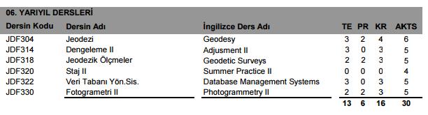
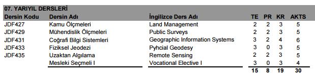
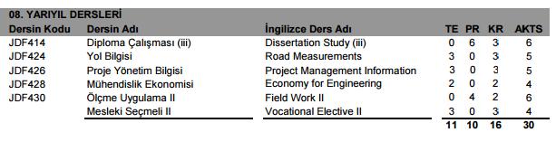
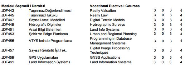
The courses presently offered in the Geomatics Engineering Program by the Department of Geodesy and Geomatics Engineering are described below.
 GGE GEODESY AND GEOMATICS ENGINEERING The courses presently offered in the Geomatics Engineering Program by the Department of Geodesy and Geomatics Engineering are described below. The first digit of the
Lecture 9: Reference Maps & Aerial Photography
 Lecture 9: Reference Maps & Aerial Photography I. Overview of Reference and Topographic Maps There are two basic types of maps? Reference Maps - General purpose maps & Thematic Maps - maps made for a specific
Introduction to GIS. Dr. M.S. Ganesh Prasad
 Introduction to GIS Dr. M.S. Ganesh Prasad Department of Civil Engineering The National Institute of Engineering, MYSORE ganeshprasad.nie@gmail.com 9449153758 Geographic Information System (GIS) Information
Chapter 1 Overview of Maps
 Chapter 1 Overview of Maps In this chapter you will learn about: Key points when working with maps General types of maps Incident specific maps Map legend and symbols Map sources A map is a navigational
Use of Corona, Landsat TM, Spot 5 images to assess 40 years of land use/cover changes in Cavusbasi
 New Strategies for European Remote Sensing, Olui (ed.) 2005 Millpress, Rotterdam, ISBN 90 5966 003 X Use of Corona, Landsat TM, Spot 5 images to assess 40 years of land use/cover changes in Cavusbasi N.
UNITED NATIONS E/CONF.96/CRP. 5
 UNITED NATIONS E/CONF.96/CRP. 5 ECONOMIC AND SOCIAL COUNCIL Eighth United Nations Regional Cartographic Conference for the Americas New York, 27 June -1 July 2005 Item 5 of the provisional agenda* COUNTRY
Derin Orhon:
 The Use of Remote Sensing and GIS Technologies for Comprehensive Wastewater Management Necla Ulugtekin*, Filiz Bektas**, Ahmet Ozgur Dogru*, Cigdem Goksel**, Idil Aslan Alaton***, Derin Orhon*** * Istanbul
(Refer Slide Time: 3:48)
") Introduction to Remote Sensing Dr. Arun K Saraf Department of Earth Sciences Indian Institute of Technology Roorkee Lecture 01 What is Satellite based Remote Sensing Hello, hello everyone this is Arun
Introduction to Remote Sensing Dr. Arun K Saraf Department of Earth Sciences Indian Institute of Technology Roorkee Lecture 01 What is Satellite based Remote Sensing Hello, hello everyone this is Arun
USING GIS CARTOGRAPHIC MODELING TO ANALYSIS SPATIAL DISTRIBUTION OF LANDSLIDE SENSITIVE AREAS IN YANGMINGSHAN NATIONAL PARK, TAIWAN
 CO-145 USING GIS CARTOGRAPHIC MODELING TO ANALYSIS SPATIAL DISTRIBUTION OF LANDSLIDE SENSITIVE AREAS IN YANGMINGSHAN NATIONAL PARK, TAIWAN DING Y.C. Chinese Culture University., TAIPEI, TAIWAN, PROVINCE
Bachelor of Geospatial Science The University of the South Pacific
 Bachelor of Geospatial Science The University of the South Pacific Geospatial Science Unit School of Geography, Earth Science and Environment Aleen Elisha Prasad Inesha Manzini Semisi Ketenilagi Geospatial
Undergraduate Study. Geomatics
 Undergraduate Study Geomatics 13 Geomatics How do satellite navigation systems work? How do we ensure construction projects match their design? How do we know the Earth s continents move? If we look at
Remote Sensing and EO activities at the University of Turku
 Remote Sensing and EO activities at the University of Turku Niina Käyhkö Associate Professor Department of Geography and Geology GEO meeting/syke May 23rd, 2018 Geospatial competence at the University
DEPARTMENT OF GEOGRAPHY B.A. PROGRAMME COURSE DESCRIPTION
 DEPARTMENT OF GEOGRAPHY B.A. PROGRAMME COURSE DESCRIPTION (3 Cr. Hrs) (2340100) Geography of Jordan (University Requirement) This Course pursues the following objectives: - The study the physical geographical
Imagery and the Location-enabled Platform in State and Local Government
 Imagery and the Location-enabled Platform in State and Local Government Fred Limp, Director, CAST Jim Farley, Vice President, Leica Geosystems Oracle Spatial Users Group Denver, March 10, 2005 TM TM Discussion
Innovation in mapping and photogrammetry at the Survey of Israel
 16, October, 2017 Innovation in mapping and photogrammetry at the Survey of Israel Yaron Felus and Ronen Regev Contents Why HD mapping? Government requirements Mapping regulations o Quality requirements
on the rapidly growing Auckland Region [Name of the Writer] [Name of the Institute]
![on the rapidly growing Auckland Region [Name of the Writer] [Name of the Institute]](/thumbs/79/79508878.jpg "on the rapidly growing Auckland Region [Name of the Writer] [Name of the Institute]") RUNNING HEAD: PROPOSAL 1 GIS and remote sensing - based approach to assess land cover classification and spatial pattern on the rapidly growing Auckland Region [Name of the Writer] [Name of the Institute]
RUNNING HEAD: PROPOSAL 1 GIS and remote sensing - based approach to assess land cover classification and spatial pattern on the rapidly growing Auckland Region [Name of the Writer] [Name of the Institute]
Development of an urban classification method using a built-up index
 Development of an urban classification method using a built-up index JIN A LEE, SUNG SOON LEE, KWANG HOON CHI Dep.Geoinformatic Engineering, University of Science & Technology Dep. Geoscience Information,
Fugro Geospatial: Turning Spatial Data into Knowledge
 Fugro Geospatial: Turning Spatial Data into Knowledge 2016 Fugro Geospatial, GIS and Consultants Locations Variety of Collection Platforms Traditional Mapping Traditional Mapping Imagery Photogrammetric
Landuse and Landcover change analysis in Selaiyur village, Tambaram taluk, Chennai
 Landuse and Landcover change analysis in Selaiyur village, Tambaram taluk, Chennai K. Ilayaraja Department of Civil Engineering BIST, Bharath University Selaiyur, Chennai 73 ABSTRACT The synoptic picture
DEVELOPMENT OF DIGITAL CARTOGRAPHIC DATABASE FOR MANAGING THE ENVIRONMENT AND NATURAL RESOURCES IN THE REPUBLIC OF SERBIA
 DEVELOPMENT OF DIGITAL CARTOGRAPHIC BASE FOR MANAGING THE ENVIRONMENT AND NATURAL RESOURCES IN THE REPUBLIC OF SERBIA Dragutin Protic, Ivan Nestorov Institute for Geodesy, Faculty of Civil Engineering,
INVESTIGATION LAND USE CHANGES IN MEGACITY ISTANBUL BETWEEN THE YEARS BY USING DIFFERENT TYPES OF SPATIAL DATA
 INVESTIGATION LAND USE CHANGES IN MEGACITY ISTANBUL BETWEEN THE YEARS 1903-2010 BY USING DIFFERENT TYPES OF SPATIAL DATA T. Murat Celikoyan, Elif Sertel, Dursun Zafer Seker, Sinasi Kaya, Uğur Alganci ITU,
ISLAMIC REPUBLIC OF IRAN NATIONAL REPORT FOR PHOTOGRAMMETRY, REMOTE SENSING AND SPATIAL INFORMATION SCIENCE
 ISLAMIC REPUBLIC OF IRAN NATIONAL REPORT FOR PHOTOGRAMMETRY, REMOTE SENSING AND SPATIAL INFORMATION SCIENCE 2004-2008 A. Eslami Rad a, M. Sarpoulaki b a Director Technical Advisor, National Cartographic
Nineteen engineering disciplines are included in the Examination Syllabus issued by the Canadian Engineering Qualifications Board of Engineers Canada.
 INTRODUCTION Nineteen engineering disciplines are included in the Examination Syllabus issued by the Canadian Engineering Qualifications Board of Engineers Canada. Each discipline examination syllabus
CE 59700: Digital Photogrammetric Systems
 CE 59700: Digital Photogrammetric Systems Fall 2016 1 Instructor: Contact Information Office: HAMP 4108 Tel: (765) 496-0173 E-mail: ahabib@purdue.edu Lectures (HAMP 2102): Monday, Wednesday & Friday (12:30
ACCURACY ASSESSMENT OF ASTER GLOBAL DEM OVER TURKEY
 ACCURACY ASSESSMENT OF ASTER GLOBAL DEM OVER TURKEY E. Sertel a a ITU, Civil Engineering Faculty, Geomatic Engineering Department, 34469 Maslak Istanbul, Turkey sertele@itu.edu.tr Commission IV, WG IV/6
Overview of Remote Sensing in Natural Resources Mapping
 Overview of Remote Sensing in Natural Resources Mapping What is remote sensing? Why remote sensing? Examples of remote sensing in natural resources mapping Class goals What is Remote Sensing A remote sensing
Cutting Edge Engineering for Modern Geospatial Systems Rear Admiral Dr. S Kulshrestha, retd
 Cutting Edge Engineering for Modern Geospatial Systems Rear Admiral Dr. S Kulshrestha, retd 11 Jun 2015 GeoIntelligence Asia 2015 The technology would become so pervasive that it becomes a part of you
DATA SOURCES AND INPUT IN GIS. By Prof. A. Balasubramanian Centre for Advanced Studies in Earth Science, University of Mysore, Mysore
 DATA SOURCES AND INPUT IN GIS By Prof. A. Balasubramanian Centre for Advanced Studies in Earth Science, University of Mysore, Mysore 1 1. GIS stands for 'Geographic Information System'. It is a computer-based
Graduate Courses Meteorology / Atmospheric Science UNC Charlotte
 Graduate Courses Meteorology / Atmospheric Science UNC Charlotte In order to inform prospective M.S. Earth Science students as to what graduate-level courses are offered across the broad disciplines of
enny Mills chool of Civil ngineering & eosciences ewcastle University
 Future of Surveying: Educating the future geospatial expert A Newcastle University perspective enny Mills chool of Civil ngineering & eosciences ewcastle University Future of surveying: Do we still need
THE NEW TECHNOLOGICAL ADVANCES IN CARTOGRAPHY
 Distr.: LIMITED ECA/NRD/CART. 9/ETH. 6 October 1996 Original: ENGLISH Ninth United Nations Regional Cartographic Conference for Africa Addis Ababa, Ethiopia 11-15 November 1996 THE NEW TECHNOLOGICAL ADVANCES
THE NEW CHALLENGES FOR THE HIGHER EDUCATION OF GEODESY IN UACEG SOFIA
 THE NEW CHALLENGES FOR THE HIGHER EDUCATION OF GEODESY IN UACEG SOFIA Ivan Kunchev University of Architecture, Civil Engineering and Geodesy, 1 Hristo Smirnenski Blvd., Sofia 1046, Bulgaria Abstract Report
10 years of monitoring of the Doesen rock glacier (Ankogel group, Austria) a review of the research activities for the time period
 a review of the research activities for the time period") 10 years of monitoring of the Doesen rock glacier (Ankogel group, Austria) a review of the research activities for the time period 1995-2005 V. Kaufmann 1, R. Ladstädter 1 and G. Kienast 2 1 Institute
10 years of monitoring of the Doesen rock glacier (Ankogel group, Austria) a review of the research activities for the time period 1995-2005 V. Kaufmann 1, R. Ladstädter 1 and G. Kienast 2 1 Institute
GEOGRAPHY (GE) Courses of Instruction
 Courses of Instruction") GEOGRAPHY (GE) GE 102. (3) World Regional Geography. The geographic method of inquiry is used to examine, describe, explain, and analyze the human and physical environments of the major regions of the
GEOGRAPHY (GE) GE 102. (3) World Regional Geography. The geographic method of inquiry is used to examine, describe, explain, and analyze the human and physical environments of the major regions of the
Faculty of Science and Technology Parthenope University Napoli
 Faculty of Science and Technology Parthenope University Napoli First Level Degree Course in COMPUTER SCIENCE (class L-31 DM 17) Years I and II running Computer Architecture with laboratory INF/01 12 Mathematics
Portfolio of karteco Cadastral Survey Department
 Portfolio of karteco Cadastral Survey Department 01-2016 Who we are? karteco Environmental & Energy Engineering Consultancy Founding members: Apostolos Karteris Dr. Environmental Engineer Marinos Karteris
GEOGRAPHY (GEOG) Geography (GEOG) 1. GEOG 11. Laboratory in Physical Geography. 1 Unit Prerequisite(s): GEOG 1; may be taken concurrently.
 Geography (GEOG) 1. GEOG 11. Laboratory in Physical Geography. 1 Unit Prerequisite(s): GEOG 1; may be taken concurrently.") Geography (GEOG) 1 GEOGRAPHY (GEOG) GEOG 1. Physical Geography: The Distribution of Natural Phenomena. 3 Units General Education Area/Graduation Requirement: Physical Science (B1), Summer Introductory
Geography (GEOG) 1 GEOGRAPHY (GEOG) GEOG 1. Physical Geography: The Distribution of Natural Phenomena. 3 Units General Education Area/Graduation Requirement: Physical Science (B1), Summer Introductory
Technical Drafting, Geographic Information Systems and Computer- Based Cartography
 Technical Drafting, Geographic Information Systems and Computer- Based Cartography Project-Specific and Regional Resource Mapping Services Geographic Information Systems - Spatial Analysis Terrestrial
Academic Model in South Africa Some Background
 Academic Model in South Africa Some Background 6 Professional models. (Land, Hydro, Engineering, Photo, GISc) 4 Technologist Models. (Engineering, Mining, Photo, GISc) 4 Technician Models. (Engineering,
WHAT YOU WILL LEARN TODAY
 WHAT YOU WILL LEARN TODAY Overview of the new QGIS Academy Curriculum Background on curriculum development Curriculum alignment with national standards Description of the five GIS courses Details of the
Route To A Remote Sensing Geology Career
 INFORMATION SYSTEMS LLC a U.S. company Route To A Remote Sensing Geology Career Today s Agenda: My Route Potential Employers & Skills Trends Going Forward Take-Away Messages GRSG - September 10, 2014 Cynthia
Building a National Data Repository
 Building a National Data Repository Mladen Stojic, Vice President - Geospatial 1/30/2013 2012 Intergraph Corporation 1 Information has meaning and gives power only when shared and distributed. Information,
CE 316 GEOMATICS COURSE NOTES DR. MOIR D HAUG, C.L.S., P. ENG. JANUARY 2012
 CE 316 GEOMATICS COURSE NOTES DR. MOIR D HAUG, C.L.S., P. ENG. JANUARY 2012 0 COURSE INFORMATION Dr Moir D Haug, P. Eng University Office 2B25 Engineering 966 5355 moir.haug@usask.ca MDH Engineered Solutions
What is GIS? Introduction to data. Introduction to data modeling
 What is GIS? Introduction to data Introduction to data modeling 2 A GIS is similar, layering mapped information in a computer to help us view our world as a system A Geographic Information System is a
VISUALIZING THE SMART CITY 3D SPATIAL INFRASTRUCTURE GEOSMART ASIA- 30 SEP, 2015
 www.aamgroup.com VISUALIZING THE SMART CITY 3D SPATIAL INFRASTRUCTURE GEOSMART ASIA- 30 SEP, 2015 Agenda AAM What is a Smart City? Data Acquisition 3D Modelling Benefits Questions AAM AAM is a Geospatial
Mapping Earth s Surface Chapter 2 Section 3
 Mapping Earth s Surface Chapter 2 Section 3 Day 1 Objective I will understand maps can be used to find locations on Earth and to represent information about features on Earth s Surface I will understand
Reminder: All answers MUST GO ON ANSWER SHEET! Answers recorded in the exam booklet will not count.
 Reminder: All answers MUST GO ON ANSWER SHEET! Answers recorded in the exam booklet will not count. 1. Identify the following acronyms; compare these platform types; provide situations where one platform
Country Report on SDI Activities in Singapore *
 UNITED NATIONS E/CONF.100/CRP.9 ECONOMIC AND SOCIAL COUNCIL Eighteenth United Nations Regional Cartographic Conference for Asia and the Pacific Bangkok, 26-29 October 2009 Item 7(a) of the provisional
Investigation of the Effect of Transportation Network on Urban Growth by Using Satellite Images and Geographic Information Systems
 Presented at the FIG Congress 2018, May 6-11, 2018 in Istanbul, Turkey Investigation of the Effect of Transportation Network on Urban Growth by Using Satellite Images and Geographic Information Systems
Sampling The World. presented by: Tim Haithcoat University of Missouri Columbia
 Sampling The World presented by: Tim Haithcoat University of Missouri Columbia Compiled with materials from: Charles Parson, Bemidji State University and Timothy Nyerges, University of Washington Introduction
ENVS S102 Earth and Environment (Cross-listed as GEOG 102) ENVS S110 Introduction to ArcGIS (Cross-listed as GEOG 110)
 ENVS S110 Introduction to ArcGIS (Cross-listed as GEOG 110)") ENVS S102 Earth and Environment (Cross-listed as GEOG 102) 1. Describe the fundamental workings of the atmospheric, hydrospheric, lithospheric, and oceanic systems of Earth 2. Explain the interactions
ENVS S102 Earth and Environment (Cross-listed as GEOG 102) 1. Describe the fundamental workings of the atmospheric, hydrospheric, lithospheric, and oceanic systems of Earth 2. Explain the interactions
DEPARTMENT OF GEOMATICS
 DEPARTMENT OF GEOMATICS UNDERGRADUATE COURSES F611800 Introduction to Geomatics (2) Definition of Surveying and its history; Coordinate system and map projection; Fundamental conception of surveying engineering;
WHAT YOU WILL LEARN TODAY
 WHAT YOU WILL LEARN TODAY Overview of the new GeoAcademy Curriculum Background on curriculum development Curriculum alignment with national standards Description of the five GIS courses Details of the
Fig. 1: Test area the Municipality of Mali Idjos, Cadastral Municipality Feketic
 Remote Sensing Application for Agricultural Land Value Classification Integrated in the Land Consolidation Survey Stojanka Brankovic, Ljiljana Parezanovic Republic Geodetic Authority, Belgrade, Serbia
CLICK HERE TO KNOW MORE
 CLICK HERE TO KNOW MORE GENERALIZATION OF TOPOGRAPHIC DATABASE FOR SERVING GEOSPATIAL DATA FOR MILITARY AND SOCIO-ECONOMIC TASKS IN VIETNAM Speaker: Lieutenant Colonel, Nguyen Dinh Minh GENERAL STAFF -
Effect of Data Processing on Data Quality
 Journal of Computer Science 4 (12): 1051-1055, 2008 ISSN 1549-3636 2008 Science Publications Effect of Data Processing on Data Quality Al Rawashdeh Samih Department of Engineering, Department of Surveying
8/28/2011. Contents. Lecture 1: Introduction to GIS. Dr. Bo Wu Learning Outcomes. Map A Geographic Language.
 Contents Lecture 1: Introduction to GIS Dr. Bo Wu lsbowu@polyu.edu.hk Department of Land Surveying & Geo-Informatics The Hong Kong Polytechnic University 1. Learning outcomes 2. GIS definition 3. GIS examples
Surveyors, Cartographers, Photogrammetrists, and Surveying and Mapping Technicians
 http://www.bls.gov/oco/ocos040.htm Surveyors, Cartographers, Photogrammetrists, and Surveying and Mapping Technicians * Nature of the Work * Training, Other Qualifications, and Advancement * Employment
a system for input, storage, manipulation, and output of geographic information. GIS combines software with hardware,
 Introduction to GIS Dr. Pranjit Kr. Sarma Assistant Professor Department of Geography Mangaldi College Mobile: +91 94357 04398 What is a GIS a system for input, storage, manipulation, and output of geographic
Geography (GEOG) Courses
 Courses") Geography (GEOG) 1 Geography (GEOG) Courses GEOG 100. Introduction to Human Geography. 4 (GE=D4) Introduction to the global patterns and dynamics of such human activities as population growth and movements,
Geography (GEOG) 1 Geography (GEOG) Courses GEOG 100. Introduction to Human Geography. 4 (GE=D4) Introduction to the global patterns and dynamics of such human activities as population growth and movements,
Modeling Coastal Change Using GIS Technology
 Emily Scott NRS 509 Final Report December 5, 2013 Modeling Coastal Change Using GIS Technology In the past few decades, coastal communities around the world are being threatened by accelerating rates of
THE ESTABLISHMENT OF DIGITAL HIGH RESOLUTION GEODATABASES FOR WEBGIS: FROM DIGITAL CAMPUS TO DIGITAL NATIONAL PARK
 THE ESTABLISHMENT OF DIGITAL HIGH RESOLUTION GEODATABASES FOR WEBGIS: FROM DIGITAL CAMPUS TO DIGITAL NATIONAL PARK Y. C. Ding a, *, C. C. Huang a a Digital Earth Research Center (DERC), Chinese Culture
10-C Approach for Quality Assesment and Accuracy of Geospatial Information in Indonesia
 10-C Approach for Quality Assesment and Accuracy of Geospatial Information in Indonesia Dr.-Ing Fahmi Amhar 1 1 Geospatial Information Agency, Jl. Jakarta-Bogor km. 46 Cibinong-Indonesia famhar@yahoocom
SHRI ANGALAMMAN COLLEGE OF ENGINEERING AND TECHNOLOGY (An ISO 9001:2008 Certified Institution) Siruganoor, Tiruchirappalli
 Siruganoor, Tiruchirappalli") SHRI ANGALAMMAN COLLEGE OF ENGINEERING AND TECHNOLOGY (An ISO 9001:2008 Certified Institution) Siruganoor, Tiruchirappalli 621 105. FS 81504 DEPARTMENT OF CIVIL ENGINEERING 1. Define remote sensing. CE-1304
SHRI ANGALAMMAN COLLEGE OF ENGINEERING AND TECHNOLOGY (An ISO 9001:2008 Certified Institution) Siruganoor, Tiruchirappalli 621 105. FS 81504 DEPARTMENT OF CIVIL ENGINEERING 1. Define remote sensing. CE-1304
Role of GIS and Remote Sensing to Environment Statistics
 United Nations Economic Commission for Africa Role of GIS and Remote Sensing to Environment Dozie Ezigbalike Data Management Coordinator A Definition Environment statistics are statistics that describe
Application of Remote Sensing and GIS in Seismic Surveys in KG Basin
 P-318 Summary Application of Remote Sensing and GIS in Seismic Surveys in KG Basin M.Murali, K.Ramakrishna, U.K.Saha, G.Sarvesam ONGC Chennai Remote Sensing provides digital images of the Earth at specific
Syllabus Reminders. Geographic Information Systems. Components of GIS. Lecture 1 Outline. Lecture 1 Introduction to Geographic Information Systems
 Syllabus Reminders Geographic Information s Lecture Introduction to Geographic Information s. Class Info: www.saigis.com/class/ 2. Office T / TH (8:00-9:30 a.m.) and (2:30 3:30pm) or Appt 3. Email: burgerpr@unk.edu