ANALYSIS OF VERTICAL MOVEMENTS DETECTED BY RADAR INTERFEROMETRY IN URBAN AREAS
|
|
|
- Eunice Barton
- 5 years ago
- Views:
Transcription
1 10TH CZECH-POLISH WORKSHOP ON RECENT GEODYNAMICS OF THE SUDETEN AND ADJACENT AREAS Szklarska Poręba, Poland, November 5 7, 2009 ANALYSIS OF VERTICAL MOVEMENTS DETECTED BY RADAR INTERFEROMETRY IN URBAN AREAS Kadlečík Pavel, Schenk Vladimír, Seidlová Zuzana, Schenková Zdeňka Centre for Earth Dynamics Research Institute of Rock Structure and Mechanics, Academy of Sciences of the Czech Republic, Prague, v.v.i.; kadlecik@irsm.cas.cz
2 Application InSAR in urban areas PSI (Persistent Scatterer interferometry) DInSAR (Differential Interferometry) InSAR data acquired in Terrafirma ESA project processed by GAMMA Remote Sensing, Switzerland 2 areas: Prague, The Ostrava region PSI - IPTA (Interferometric Point Target Analysis) (Werner et al. 2003) primary analysis (derived from ERS-1/2) additional analysis (especially two-year - ERS-1/2, ENVISAT) RESULTS average deformation rate (change in vertical position) for PS time series for PS Differential interferograms (only for the Ostrava region) 1-day, 35- to 71-day processed from ERS-1/2 scenes during RESULTS sum of vertical movement for processed period (generally 35 or 70 days)
 average deformation rates")


3 PRAGUE AREA PSI (Persistent Scatterer interferometry) average deformation rates and are included because of allowing different def. rates Study areas 3 examples 1. STODŮLKY CANALIZATION construction of canalization feeder ( ) jump nature of subsidence complicated geological situation 2. BRANÍK RAILWAY TRACK slow subsidence for whole period cause of movement: instability of sediments building the railway embankment local distinction of movement
4 OSTRAVA REGION processed by GAMMA Remote Sensing PSI - IPTA (Interferometric Point Target Analysis) average deformation rates average deformation rates for shorter periods , , , (all ERS-1/2), (ENVISAT) differential interferograms 1-day, 35-day, 70-day from period undermined region subsidence up to tens of cm/year 3. MICHAL MINE former mine Petr Cingr located in settled parts of the Ostrava city closed in April 1994 analysis of subsidence during coal-mining and after Study areas 3 examples
 feeder kanalizační č přivqděč builded")


 housing estate Stodůlky")
5 1. STODŮLKY CANALIZATION construction of canalization (sewer) feeder kanalizační č přivqděč builded ; in depth m under surface subsidence along the line of feeder average vertical movements ( ) up to 4,5 mm per year jump nature of movement 5-20 mm during 1-7 months analysed data - PSI complicated geological situation (silurianordovician complex) housing estate Stodůlky builded in the 1980s line of drainage
6 1. STODŮLKY CANALIZATION
7 Cross-section profiles 1. STODŮLKY CANALIZATION average deformation rates (mm/year) 4 2 A A C B 4 2 B C line of drainage


8 GEOLOGY - ordovician-silurian complex - zvrásnění komplex sedimentárních hornin středního ř a svrchního ordoviku a spodního siluru s vulkanickými průniky diabazových těles a žil - jílovité a prachovité břidlice, písčité břidlice až pískovce, produkty diabazového vulkanismu 1. STODŮLKY CANALIZATION


9 1. STODŮLKY CANALIZATION Time series analysis jump 5-20 mm during 1-7 months along the line of canalization


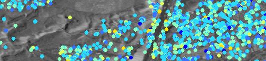


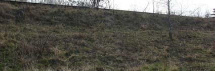

10 track runs on railway embankment (2-3 m high) h) m far from the Vltava river embankment was transfered towards to river (finished in 1992) part of antiflood protection of Prague analysed data - PSI BRANÍK RAILWAY TRACK
11 subsidence of track varying in 1,5 65 6,5 mm per year ( ) subsidence is evident for whole period BRANÍK RAILWAY TRACK Time series character of movement
12 Time series analysis detected 2 events November January 1993 August November 2004 flood in summer 2002 water rised 1 m under top of embankment not distinct display on time series of PS 2. BRANÍK RAILWAY TRACK flood
13 2. BRANÍK RAILWAY TRACK 60,000 40,000 20,000 0, ,000-40,000-60,000 60,000 40,000 20,000 0, ,000-40,000-60,000 60,000 40,000 20,000 possible explanation - non-uniform sinking of the embankment-massmass not long from its building 0, ,000-40,000-60,000


14 3. MICHAL MINE former Petr Cingr mine czech part of Upper Silesian Basin coal mining ended in 1994 located in settled part of Ostrava City analysed data - PSI , DInSAR (about 20 differential interferograms from these period)


")


15 3. MICHAL MINE MAXIMUM DEFORMATION RATE (mm/year) CENTER OTHER mining ended
16 3. MICHAL MINE


17 absence of PS 3. MICHAL MINE
18 3. MICHAL MINE Total rate of subsidence for period (mm) mining ended
19 Application of InSAR in urban areas Prague very stable area (92% of PS movement up to +-2 mm/year in period ) PSI data can detect long-term movements in mm range Short-term movements in mm and cm range The Ostrava region primary cause of movement coal mining subsidence bid up to tens of centimeter t per year PSI data not detected maximum rate of movement (center of sudsiding depression) can detect subsidence in period after the end of the coal mining DInSAR data can detect movements in tens of cm per year maximum detectable rate of movement (wavelength of ERS-1/2, ENVISAT 56 mm) InSAR data can detect origin and spatio-temporaltemporal progress of subsiding depression For analysing InSAR dat vertical movement (from changes in the LOS direction) > possible horizontal movement reference point (relative values) PSI time series the value of vertical position not for every repeat cycle (e.g. 35 days)
20 Děkuji za pozornost Dziękuję za uwagę
A COMPREHENSIVE ANALYSIS OF THE CAPABILITES AND LIMITATIONS OF PSI
 A COMPREHENSIVE ANALYSIS OF THE CAPABILITES AND LIMITATIONS OF PSI Rachel Holley, InSAR Surveying Consultant InSAR Surveying Team Fugro NPA Satellite Mapping Introduction Look at the capabilities and limitations
THE FEASIBILITY AND APPLICATION OF PSI TO DETECT A RANGE OF GROUND AND STRUCTURE MOTION PHENOMENA.
 THE FEASIBILITY AND APPLICATION OF PSI TO DETECT A RANGE OF GROUND AND STRUCTURE MOTION PHENOMENA. Rachel Holley, InSAR Surveying Consultant InSAR Surveying Team Fugro NPA Satellite Mapping Introduction
Analysis of mining deformations based on PSInSAR technique case study of the Walbrzych coal mines (Poland)
") Analysis of mining deformations based on PSInSAR technique case study of the Walbrzych coal mines (Poland) Dr. Jan Blachowski, Dr. Wojciech Milczarek Faculty of Geoengineering, Mining and Geology, Wroclaw
Analysis of mining deformations based on PSInSAR technique case study of the Walbrzych coal mines (Poland) Dr. Jan Blachowski, Dr. Wojciech Milczarek Faculty of Geoengineering, Mining and Geology, Wroclaw
APPLICABILITY OF PSINSAR FOR BUILDING HAZARD IDENTIFICATION
 APPLICABILITY OF PSINSAR FOR BUILDING HAZARD IDENTIFICATION. STUDY OF THE 29 JANUARY 2006 KATOWICE EXHIBITION HALL COLLAPSE AND THE 24 FEBRUARY 2006 MOSCOW BASMANNY MARKET COLLAPSE Zbigniew Perski (1),
Geodynamic Pattern of the West Bohemia during the October 2008 Earthquake Swarm
 10th Czech-Polish Workshop on RECENT GEODYNAMICS OF THE SUDETEN AND ADJACENT AREAS Szklarska Poręba, November 5-7, 2009 Geodynamic Pattern of the West Bohemia during the October 2008 Earthquake Swarm Vladimír
Evaluation of subsidence from DinSAR techniques using Envisat-ASAR data at Toluca Valley Basin, Mexico.
 Evaluation of subsidence from DinSAR techniques using Envisat-ASAR data at Toluca Valley Basin, Mexico. Norma Angélica Dávila Hernández 1 Delfino Madrigal Uribe 1 Xanat Antonio Némiga 1 1 Autonomous University
EO, Land Motion and Climate Adaptation in Mediterranean Cities June 2014, Athens
 EO, Land Motion and Climate Adaptation in Mediterranean Cities 10-11 June 2014, Athens 1 Context UN Report: Water and Cities Facts and Figures 2 Context UN Report: Water and Cities Facts and Figures 3
Continuous Risk Assessment of Structures and Plants in Areas of Ground Deformation Susceptibility by Space-based SAR/ASAR Interferometry
 CCN4 Project Continuous Risk Assessment of Structures and Plants in Areas of Ground Deformation Susceptibility by Space-based SAR/ASAR Interferometry Issaak Parcharidis*, Michael Foumelis and Penelope
Advanced interpretation of land subsidence by validating multiinterferometric SAR data: the case study of Anthemountas basin (Northern Greece)
") Revision of paper Advanced interpretation of land subsidence by validating multiinterferometric SAR data: the case study of Anthemountas basin (Northern Greece) By Raspini et al. General comments This
Revision of paper Advanced interpretation of land subsidence by validating multiinterferometric SAR data: the case study of Anthemountas basin (Northern Greece) By Raspini et al. General comments This
ALOS PI Symposium 2009, 9-13 Nov 2009 Hawaii MOTION MONITORING FOR ETNA USING ALOS PALSAR TIME SERIES
 ALOS PI Symposium 2009, 9-13 Nov 2009 Hawaii ALOS Data Nodes: ALOS RA-094 and RA-175 (JAXA) MOTION MONITORING FOR ETNA USING ALOS PALSAR TIME SERIES Urs Wegmüller, Charles Werner and Maurizio Santoro Gamma
GEODYNAMICS AND DEFORMATIONS OF THE SUDETIC GEOLOGICAL STRUCTURAL BLOCKS
 Proceedings, 11 th FIG Symposium on Deformation Measurements, Santorini, Greece, 2003. GEODYNAMICS AND DEFORMATIONS OF THE SUDETIC GEOLOGICAL STRUCTURAL BLOCKS Vladimír Schenk 1, Zuzana Jechumálová 2,
GPS and GIS Assisted Radar Interferometry
 GPS and GIS Assisted Radar Interferometry Linlin Ge, Xiaojing Li, Chris Rizos, and Makoto Omura Abstract Error in radar satellite orbit determination is a common problem in radar interferometry (INSAR).
IDENTIFICATION AND CHANGES OF SUBSIDENCE BASINS CAUSED BY COAL MINING ACTIVITY IN UPPER SILESIA USING SATELLITE INTERFEROMETRIC DATA
 IDENTIFICATION AND CHANGES OF SUBSIDENCE BASINS CAUSED BY COAL MINING ACTIVITY IN UPPER SILESIA USING SATELLITE INTERFEROMETRIC DATA Maria Przyłucka (1), Marek Graniczny (1), Zbigniew Kowalski (1) (1)
(2) INERIS-RNOS, Ecoles des Mines de Nancy - Parc de Saurupt Nancy Cedex - France
 INERIS-RNOS, Ecoles des Mines de Nancy - Parc de Saurupt Nancy Cedex - France") DETECTION AND CHARACTERISATION OF RESIDUAL MINING SUBSIDENCE USING DINSAR AND PS INTERFEROMETRY: APPLICATION TO NORD/PAS-DE-CALAIS COALBASIN (NORTHERN FRANCE) Guéguen, Y. (1,2), Deffontaines, B. (1), Al
DETECTION AND CHARACTERISATION OF RESIDUAL MINING SUBSIDENCE USING DINSAR AND PS INTERFEROMETRY: APPLICATION TO NORD/PAS-DE-CALAIS COALBASIN (NORTHERN FRANCE) Guéguen, Y. (1,2), Deffontaines, B. (1), Al
ERS-ENVISAT CROSS-INTERFEROMETRY SIGNATURES OVER DESERTS. Urs Wegmüller, Maurizio Santoro and Christian Mätzler
 ERS-ENVISAT CROSS-INTERFEROMETRY SIGNATURES OVER DESERTS Urs Wegmüller, Maurizio Santoro and Christian Mätzler Gamma Remote Sensing AG, Worbstrasse 225, CH-3073 Gümligen, Switzerland, http://www.gamma-rs.ch,
GMES Terrafirma II Stassfurt Case Study - Preliminary Results -
 GMES Terrafirma II Stassfurt Case Study - Preliminary Results - Friedrich Kuehn BGR/Germany Email: friedrich.kuehn@bgr.de PSI-Processing by DLR Oberpfaffenhofen/Germany The Study Area: - The Stassfurt/Bernburg
Implementation of Multi-Temporal InSAR to monitor pumping induced land subsidence in Pingtung Plain, Taiwan
 Implementation of Multi-Temporal InSAR to monitor pumping induced land subsidence in Pingtung Plain, Taiwan Presenter: Oswald Advisor: Chuen-Fa Ni Date: March 09, 2017 Literature Review Pingtung Plain
The Potential of High Resolution Satellite Interferometry for Monitoring Enhanced Oil Recovery
 The Potential of High Resolution Satellite Interferometry for Monitoring Enhanced Oil Recovery Urs Wegmüller a Lutz Petrat b Karsten Zimmermann c Issa al Quseimi d 1 Introduction Over the last years land
DETECTION OF GROUND MOTION IN THE LISBON REGION WITH PERSISTENT SCATTERER INTERFEROMETRY (PSI)
") DETECTION OF GROUND MOTION IN THE LISBON REGION WITH PERSISTENT SCATTERER INTERFEROMETRY (PSI) Sandra HELENO 1, Afonso LOUREIRO 1,2, João FONSECA 1, João MATOS 1, João CARVALHO 3, Geraint COOKSLEY 4, Ana
DETECTION OF GROUND MOTION IN THE LISBON REGION WITH PERSISTENT SCATTERER INTERFEROMETRY (PSI) Sandra HELENO 1, Afonso LOUREIRO 1,2, João FONSECA 1, João MATOS 1, João CARVALHO 3, Geraint COOKSLEY 4, Ana
MAPPING DEFORMATION OF MAN-MADE LINEAR FEATURES USING DINSAR TECHNIQUE
 MAPPING DEFORMATION OF MAN-MADE LINEAR FEATURES USING DINSAR TECHNIQUE H. Wu a, *, Y. Zhang a, J. Zhang a, X. Chen b a Key Laboratory of Mapping from Space of State Bureau of Surveying and Mapping, Chinese
P079 First Results from Spaceborne Radar Interferometry for the Study of Ground Displacements in Urban Areas SUMMARY
 P079 First Results from Spaceborne Radar Interferometry for the Study of Ground Displacements in Urban Areas C.M. Crosetto (Instituto de Geomatica), C.A. Casas (University of Barcelona), R.G. Ranieri (University
J. Manuel Delgado (1,2), Roberto Cuccu (1), Giancarlo Rivolta (1)
, Roberto Cuccu (1), Giancarlo Rivolta (1)") MONITORING GROUND DEFORMATION USING PERSISTENT SCATTERS INTERFEROMETRY (PSI) AND SMALL BASELINES (SBAS) TECHNIQUES INTEGRATED IN THE ESA RSS SERVICE: THE CASE STUDY OF VALENCIA, ROME AND SOUTH SARDINIA
MONITORING GROUND DEFORMATION USING PERSISTENT SCATTERS INTERFEROMETRY (PSI) AND SMALL BASELINES (SBAS) TECHNIQUES INTEGRATED IN THE ESA RSS SERVICE: THE CASE STUDY OF VALENCIA, ROME AND SOUTH SARDINIA
GMES Terrafirma II Stassfurt Case Study - Preliminary Results -
 GMES Terrafirma II Stassfurt Case Study - Preliminary Results - Presenter: Kai Hahne Author: Friedrich Kuehn BGR/Germany Email: kai.hahne@bgr.de friedrich.kuehn@bgr.de PSI-Processing by DLR Oberpfaffenhofen/Germany
DIFFERENTIAL INSAR STUDIES IN THE BOREAL FOREST ZONE IN FINLAND
 DIFFERENTIAL INSAR STUDIES IN THE BOREAL FOREST ZONE IN FINLAND Kirsi Karila (1,2), Mika Karjalainen (1), Juha Hyyppä (1) (1) Finnish Geodetic Institute, P.O. Box 15, FIN-02431 Masala, Finland, Email:
Deformation measurement using SAR interferometry: quantitative aspects
 Deformation measurement using SAR interferometry: quantitative aspects Michele Crosetto (1), Erlinda Biescas (1), Ismael Fernández (1), Ivan Torrobella (1), Bruno Crippa (2) (1) (2) Institute of Geomatics,
PERSISTENT SCATTERER SAR INTERFEROMETRY APPLICATIONS ON LANDSLIDES IN CARPATHIANS (SOUTHERN POLAND)
") Acta Geodyn. Geomater., Vol. 7, No. 3 (159), 1 7, 2010 PERSISTENT SCATTERER SAR INTERFEROMETRY APPLICATIONS ON LANDSLIDES IN CARPATHIANS (SOUTHERN POLAND) Zbigniew PERSKI 1) *, Tomasz WOJCIECHOWSKI 1)
Acta Geodyn. Geomater., Vol. 7, No. 3 (159), 1 7, 2010 PERSISTENT SCATTERER SAR INTERFEROMETRY APPLICATIONS ON LANDSLIDES IN CARPATHIANS (SOUTHERN POLAND) Zbigniew PERSKI 1) *, Tomasz WOJCIECHOWSKI 1)
Observing Dam s Movements with Spaceborne SAR Interferometry
 Observing Dam s Movements with Spaceborne SAR Interferometry 26 Milan Lazecký, Daniele Perissin, Wang Zhiying, Lei Ling, and Qin Yuxiao Abstract Advantages of satellite synthetic aperture radar (SAR) interferometry
Terrafirma monitoring and mapping landslide services for Europe based on InSAR satellite data
 Department of Earth Sciences CENTRE OF COMPETENCE OF THE CIVIL PROTECTION DEPARTMENT PRESIDENCY OF THE COUNCIL OF MINISTERS Terrafirma monitoring and mapping landslide services for Europe based on InSAR
Copernicus for Raw Materials Workshop
 Copernicus for Raw Materials Workshop Copernicus 40 User Years Forum Listening Industry Workshop, to the Beat 5th September of the Earth 2016, Brussels About http://copernicus.eu/raw-materials-workshop
MODELING INTERFEROGRAM STACKS FOR SENTINEL - 1
 MODELING INTERFEROGRAM STACKS FOR SENTINEL - 1 Fabio Rocca (1) (1) Politecnico di Milano, Via Ponzio 34/5, 20133 Milano, Italy, Email: rocca@elet.polimi.it ABSTRACT The dispersion of the optimal estimate
.Hana DOLEŽALOVÁ, Vlastimil KAJZAR, Kamil SOUČEK and Lubomír STAŠ
 Acta Geodyn. Geomater., Vol. 6, No. 3 (155), 359 367, 2009 EVALUATION OF MINING SUBSIDENCE USING GPS DATA.Hana DOLEŽALOVÁ, Vlastimil KAJZAR, Kamil SOUČEK and Lubomír STAŠ Institute of Geonics, Academy
COAL MINE LAND SUBSIDENCE MONITORING BY USING SPACEBORNE INSAR DATA-A CASE STUDY IN FENGFENG, HEBEI PROVINCE, CHINA
 COAL MINE LAND SUBSIDENCE MONITORING BY USING SPACEBORNE INSAR DATA-A CASE STUDY IN FENGFENG, HEBEI PROVINCE, CHINA Li Cao a, Yuehua Zhang a, Jianguo He a, Guang Liu b,huanyin Yue b, Runfeng Wang a, Linlin
PERSISTENT SCATTERER INTERFEROMETRY: POTENTIAL AND LIMITS
 PERSISTENT SCATTERER INTERFEROMETRY: POTENTIAL AND LIMITS M. Crosetto a, O. Monserrat a, A. Jungner, B. Crippa b a Institute of Geomatics, Av. del Canal Olímpic, s/n, Castelldefels, E-08860, Spain (michele.crosetto,
CHINA-ITALY BILATERAL SYMPOSIUM ON THE COASTAL ZONE: EVOLUTION AND SAFEGUARD
 CHINA-ITALY BILATERAL SYMPOSIUM ON THE COASTAL ZONE: EVOLUTION AND SAFEGUARD 4-8 November 2007 Bologna, ITALY Editors F.Marabini, A.Galvani, M.Ciabatti Editorial Assistant M.Barazutti C.N.R. Bologna LAND
Improved PSI Performance for Landslide Monitoring Applications. J. Duro, R. Iglesias, P. Blanco-Sánchez, F. Sánchez and D. Albiol
 Improved PSI Performance for Landslide Monitoring Applications J. Duro, R. Iglesias, P. Blanco-Sánchez, F. Sánchez and D. Albiol Outline Area of Study Previous PSI (and others) studies Main conclusions
Infrastructure Non-Linear Deformation Monitoring Via Satellite Radar Interferometry
 Available online at www.sciencedirect.com ScienceDirect Procedia Technology 00 (2014) 000 000 www.elsevier.com/locate/procedia CENTERIS 2014 - Conference on ENTERprise Information Systems / ProjMAN 2014
GEOLOGY OF PRAGUE ITS INTERACTION WITH THE PRAGUE METRO
 Underground M3 meeting, November 3-5, 2008, Prague GEOLOGY OF PRAGUE ITS INTERACTION WITH THE PRAGUE METRO Svatoslav Chamra Department of Geotechnics Faculty of Civil Engineering Czech Technical University
SAR APPLICATIONS IN GREECE With emphasis for Harokopio University/ Dep. of Geography activities
 SAR APPLICATIONS IN GREECE With emphasis for Harokopio University/ Dep. of Geography activities Issaak Parcharidis, Assist. Prof. Harokopio University of Athens Department of Geography parchar@hua.gr 4
Abstract. 1. Introduction
 MONITORING AND INVESTIGATING CAUSES OF SHORT- AND LONG- TERM GROUND DEFORMATION BY IMPLEMENTING SAR INTERFEROMETRIC TECHNIQUES IN THE SETTLEMENT OF LARISSA, CENTRAL GREECE Abstract Falah Fakhri Department
VALIDATION OF THE PERMANENT SCATTERERS TECHNIQUE IN URBAN AREAS
 VALIDATION OF THE PERMANENT SCATTERERS TECHNIQUE IN URBAN AREAS Alessandro Ferretti, Claudio Prati, Fabio Rocca, Carlo Colesanti Dipartimento di Elettonica e Informazione Politecnico di Milano Piazza L.
SAR interferometry Status and future directions. Rüdiger Gens
 SAR interferometry Status and future directions Rüdiger Gens Polarimetric InSAR Polarimetric InSAR InSAR - Status and future directions sensitivity to changes in surface scattering, even in the presence
Deformations of highway over undermined Ostrava-Svinov area monitored by InSAR using limited set of SAR images
 Available online at www.sciencedirect.com ScienceDirect Procedia Technology 00 (2014) 000 000 www.elsevier.com/locate/procedia CENTERIS 2014 - Conference on ENTERprise Information Systems / ProjMAN 2014
POSTSEISMIC DEFORMATION IN SOUTH ICELAND STUDIED USING MULTIPLE ACQUISTION RADAR INTERFEROMETRY
 POSTSEISMIC DEFORMATION IN SOUTH ICELAND STUDIED USING MULTIPLE ACQUISTION RADAR INTERFEROMETRY Sigurjón Jónsson (1), Jörn Hoffmann (2), Thóra Árnadóttir (3) (1) Institute of Geophysics, ETH Zurich, Schafmattstr.
CSK AO project workshop. AO CSK 3655 Continuous subsidence monitoring employing Cosmo-Skymed constellation.
 CSK AO project workshop AO CSK 3655 Continuous subsidence monitoring employing Cosmo-Skymed constellation. Pablo Blanco Sánchez, Roman Arbiol, Fernando Pérez pablo.blanco@icc.cat Roma 8/5/11 Outline Project
118 EXPERIENCE OF APPLICATION INSAR TECHNOLOGY IN POLAND MINING INDUSTRY
 118 EXPERIENCE OF APPLICATION INSAR TECHNOLOGY IN POLAND MINING INDUSTRY Edward Popiolek, Artur Krawczyk, University of Science and Technology AGH, Krakow, Poland Summary: The article presents the experience
ERS Track 98 SAR Data and InSAR Pairs Used in the Analysis
 ERS Track 98 SAR Data and InSAR Pairs Used in the Analysis Date 1 Date 2 Date 1 Date 2 Date 1 Date 2 Date 1 Date 2 7/17/1992 6/19/2000 7/17/1992 7/2/1993 9/10/1993 10/28/1996 9/3/1995 10/18/1999 9/25/1992
Objectives and hypotheses. Remote sensing: applications for landslide hazard assessment and risk management. Ping Lu (University of Firenze) Methods
 Methods") Topical Workshop Remote sensing: applications for landslide hazard assessment and risk management Ping Lu (University of Firenze) Supervisors: Prof. Nicola Casagli; Prof. Filippo Catani (Unifi) Dr. Veronica
Topical Workshop Remote sensing: applications for landslide hazard assessment and risk management Ping Lu (University of Firenze) Supervisors: Prof. Nicola Casagli; Prof. Filippo Catani (Unifi) Dr. Veronica
Monitoring of landslide dynamics with LIDAR, SAR interferometry and photogrammetry. Case study of Kłodne landslide (Southern Poland)
") Proceedings of World Landslide Forum 3, 2-6 June 2014, Beijing Monitoring of landslide dynamics with LIDAR, SAR interferometry and photogrammetry. Case study of Kłodne landslide (Southern Poland) Zbigniew
Proceedings of World Landslide Forum 3, 2-6 June 2014, Beijing Monitoring of landslide dynamics with LIDAR, SAR interferometry and photogrammetry. Case study of Kłodne landslide (Southern Poland) Zbigniew
Application of satellite InSAR data for hydrocarbon reservoir monitoring
 Application of satellite InSAR data for hydrocarbon reservoir monitoring A. Tamburini, A. Belson, A. Ferretti, F. Novali TRE Milano, Italy Copyright - Tele-Rilevamento Europa - 2004 Outline SqueeSAR TM
Retrieving 3D deformation pattern of a landslide with hiresolution InSAR and in-situ measurements: Just landslide case-study
 Retrieving 3D deformation pattern of a landslide with hiresolution InSAR and in-situ measurements: Just landslide case-study Zbigniew Perski (1), Petar Marinković (2), Yngvar Larsen (3), Tomasz Wojciechowski
Terrafirma Persistent Scatterer Processing Validation
 Terrafirma Persistent Scatterer Processing Validation Nico Adam (1), Alessandro Parizzi (1), Michael Eineder (1), Michele Crosetto () (1) Remote Sensing Technology Institute () Institute of Geomatics Signal
Dr. Simon Plank. German Remote Sensing Data Center (DFD), German Aerospace Center (DLR)
, German Aerospace Center (DLR)") Pre-survey suitability analysis of the differential and persistent scatterer synthetic ti aperture radar interferometry t method for deformation monitoring of landslides Dr. Simon Plank German Remote Sensing
Pre-survey suitability analysis of the differential and persistent scatterer synthetic ti aperture radar interferometry t method for deformation monitoring of landslides Dr. Simon Plank German Remote Sensing
Report no.: ISSN Grading: Open
 Geological Survey of Norway N-7491 Trondheim, Norway REPORT Report no.: 2005.082 ISSN 0800-3416 Grading: Open Title: Subsidence in Trondheim, 1992-2003: Results of PSInSAR analysis Authors: Dehls, J. F.
Application of advanced InSAR techniques for the measurement of vertical and horizontal ground motion in longwall minings
 University of Wollongong Research Online Coal Operators' Conference Faculty of Engineering and Information Sciences 2013 Application of advanced InSAR techniques for the measurement of vertical and horizontal
Journal of Geodynamics
 Journal of Geodynamics 49 (2010) 161 170 Contents lists available at ScienceDirect Journal of Geodynamics journal homepage: http://www.elsevier.com/locate/jog Recent advances on surface ground deformation
CAPABILITY OF DETECTING RAPID SUBSIDENCE WITH COSMO SKYMED AND SENTINEL-1 DATASET OVER KONYA CITY
 CAPABILITY OF DETECTING RAPID SUBSIDENCE WITH COSMO SKYMED AND SENTINEL-1 DATASET OVER KONYA CITY Fatma CANASLAN ÇOMUT (1), Aydın USTUN (2), Milan LAZECKY (3), Daniele PERISSIN (4) (1) Disaster & Emergency
Ground deformation monitoring in Pearl River Delta region with Stacking D-InSAR technique
 Ground deformation monitoring in Pearl River Delta region with Stacking DInSAR technique Zhao Qing*, LIN Hui, JIANG Liming Institute of Space and Earth Information Science, Room 615, Esther Lee Building,
PSI Precision, accuracy and validation aspects
 PSI Precision, accuracy and validation aspects Urs Wegmüller Gamma Remote Sensing AG, Gümligen, Switzerland, wegmuller@gamma-rs.ch Contents - Precision - Accuracy - Systematic errors - Atmospheric effects
PSI analysis of ground deformations along the south-western coast of the Gulf of Gdansk (Poland)
") FRINGE 2009 WORKSHOP, Advances in the Science and Applications of SAR Interferometry 30 November 4 December 2009 ESA-ESRIN Frascati, Italy PSI analysis of ground deformations along the south-western coast
FRINGE 2009 WORKSHOP, Advances in the Science and Applications of SAR Interferometry 30 November 4 December 2009 ESA-ESRIN Frascati, Italy PSI analysis of ground deformations along the south-western coast
A DInSAR Investigation of the Ground Settlement Time Evolution of Ocean-Reclaimed Lands in Shanghai
 A DInSAR Investigation of the Ground Settlement Time Evolution of Ocean-Reclaimed Lands in Shanghai Dr 3 project Id. 10644 Zhao, Qing 1 ; Pepe, Antonio 2 ; Gao, Wei 1 ; Li, Xiaofeng 3,4 ; Lu, Zhong 5 ;
Università di Roma La Sapienza, Facoltà d Ingegneria, Dipartimento di Idraulica,Trasporti e Strade (D.I.T.S.) 00185, Roma, Italy
 00185, Roma, Italy") DORIS FP7-EU PROJECT: EXPLOITATION OF 20 YEARS DINSAR DATA ARCHIVE FOR LANDSLIDE MONITORING Manunta M. (1), Calò F. (1), Paglia L., (1), Bonano M. (1,2), Lanari R. (1) (1) IREA-CNR, Via Diocleziano 328,
DORIS FP7-EU PROJECT: EXPLOITATION OF 20 YEARS DINSAR DATA ARCHIVE FOR LANDSLIDE MONITORING Manunta M. (1), Calò F. (1), Paglia L., (1), Bonano M. (1,2), Lanari R. (1) (1) IREA-CNR, Via Diocleziano 328,
Haiti Earthquake (12-Jan-2010) co-seismic motion using ALOS PALSAR
 co-seismic motion using ALOS PALSAR") Haiti Earthquake (12-Jan-2010) co-seismic motion using ALOS PALSAR Urs Wegmüller, Charles Werner, Maurizio Santoro Gamma Remote Sensing, CH-3073 Gümligen, Switzerland SAR data: JAXA, METI; PALSAR AO Project
Haiti Earthquake (12-Jan-2010) co-seismic motion using ALOS PALSAR Urs Wegmüller, Charles Werner, Maurizio Santoro Gamma Remote Sensing, CH-3073 Gümligen, Switzerland SAR data: JAXA, METI; PALSAR AO Project
Use of space-borne DInSAR data to optimize landslide numerical models: the example of an ancient landslide in El Portalet, Central Pyrenees, Spain
 FRINGE 2015 Workshop ESA-ESRIN, 23-27 March, 2015 Use of space-borne DInSAR data to optimize landslide numerical models: the example of an ancient landslide in El Portalet, Central Pyrenees, Spain Andrea
Retrieval of the Long Term Ground Settlement of Ocean Reclaimed Land in Shanghai with Multi Platform Time-series InSAR
 Retrieval of the Long Term Ground Settlement of Ocean Reclaimed Land in Shanghai with Multi Platform Time-series InSAR Dr 3 project Id. 10644 Zhao, Qing 1 ; Pepe, Antonio 2 ; Bonano, Manuela 2 ; Gao, Wei
Publication V Finnish Society of Photogrammetry and Remote Sensing (FSPRS)
") Publication V Kirsi Karila, Mika Karjalainen, and Juha Hyyppä. 2005. Urban land subsidence studies in Finland using synthetic aperture radar images and coherent targets. The Photogrammetric Journal of
Publication V Kirsi Karila, Mika Karjalainen, and Juha Hyyppä. 2005. Urban land subsidence studies in Finland using synthetic aperture radar images and coherent targets. The Photogrammetric Journal of
Ground surface deformation of L Aquila. earthquake revealed by InSAR time series
 Ground surface deformation of L Aquila earthquake revealed by InSAR time series Reporter: Xiangang Meng Institution: First Crust Monitoring and Application Center, CEA Address: 7 Naihuo Road, Hedong District
On the variations of InSAR-ICA altitudes in a mountain area of the Sele Valley (South Italy)
") ANNALS OF GEOPHYSICS, VOL. 52, N. 2, April 2009 On the variations of InSAR-ICA altitudes in a mountain area of the Sele Valley (South Italy) Paola Ballatore Mediterranean Agency for Remote Sensing and
ANNALS OF GEOPHYSICS, VOL. 52, N. 2, April 2009 On the variations of InSAR-ICA altitudes in a mountain area of the Sele Valley (South Italy) Paola Ballatore Mediterranean Agency for Remote Sensing and
Subsidence-induced fault
 Surveying Monitoring underground coal mining-induced subsidence by Yaobin Sheng, Linlin Ge, Chris Rizos, University of New South Wales, and Yunjia Wang, China University of Mining and Technology This paper
SLOPE STABILITY MONITORING USING SPACE-BORNE REPEAT- PASS SAR INTERFEROMETRY
 SLOPE STABILITY MONITORING USING SPACE-BORNE REPEAT- PASS SAR INTERFEROMETRY Urs WEGMÜLLER 1, Charles WERNER 1, Tazio STROZZI 1, Andreas WIESMANN 1, and Hugo RAETZO 2 1 Gamma Remote Sensing AG, Switzerland
RADAR Remote Sensing Application Examples
 RADAR Remote Sensing Application Examples! All-weather capability: Microwave penetrates clouds! Construction of short-interval time series through cloud cover - crop-growth cycle! Roughness - Land cover,
40 Years Listening to the Beat of the Earth
 EU-LA Mining & Exploration Convention Earth Observation in support of sustainable mining by the Geological Surveys of Europe Gerardo Herrera Veronika Kopačková Eleftheria Poyiadji Maria Przyłucka 40 Years
Lecture 15: Subsidence
 Lecture 15: Subsidence Key Questions 1. How does removal of groundwater cause subsidence on a regional scale? 2. Under what conditions does a building sink into sediment? 3. Why do clays consolidate more
Pre-eruptive ground deformation of Azerbaijan mud volcanoes detected through satellite radar interferometry (DInSAR)
") Pre-eruptive ground deformation of Azerbaijan mud volcanoes detected through satellite radar interferometry (DInSAR) Tectonophysics 637 (2014) 163 177 Speaker:Yi-Huei,Cho Advisor :Loung-Yie,Tsai Date:2016/12/08
Pre-eruptive ground deformation of Azerbaijan mud volcanoes detected through satellite radar interferometry (DInSAR) Tectonophysics 637 (2014) 163 177 Speaker:Yi-Huei,Cho Advisor :Loung-Yie,Tsai Date:2016/12/08
Title: Effect on surface deformation resulting from mining activity on value of property valuation : a case study from Jastrzębie-Zdrój region
 Title: Effect on surface deformation resulting from mining activity on value of property valuation : a case study from Jastrzębie-Zdrój region Author: Paweł Pala Citation style: Pala Paweł. (2018). Effect
DETECTING ICE MOTION IN GROVE MOUNTAINS, EAST ANTARCTICA WITH ALOS/PALSAR AND ENVISAT/ASAR DATA
 DETECTING ICE MOTION IN GROVE MOUNTAINS, EAST ANTARCTICA WITH ALOS/PALSAR AND ENVISAT/ASAR DATA TIAN Xin (1), LIAO Mingsheng (1), ZHOU Chunxia (2), ZHOU Yu (3) (1) State Key Laboratory of Information Engineering
TEMPORAL VARIABILITY OF ICE FLOW ON HOFSJÖKULL, ICELAND, OBSERVED BY ERS SAR INTERFEROMETRY
 TEMPORAL VARIABILITY OF ICE FLOW ON HOFSJÖKULL, ICELAND, OBSERVED BY ERS SAR INTERFEROMETRY Florian Müller (1), Helmut Rott (2) (1) ENVEO IT, Environmental Earth Observation GmbH, Technikerstrasse 21a,
The PaTrop Experiment
 Improved estimation of the tropospheric delay component in GNSS and InSAR measurements in the Western Corinth Gulf (Greece), by the use of a highresolution meteorological model: The PaTrop Experiment N.
STUDY OF SITE EFFECT USING MINING INDUCED SEISMIC EVENTS AND AMBIENT NOISE FROM KARVINÁ REGION
 Acta Geodyn. Geomater., Vol. 5, No. 2 (150), 105 113, 2008 STUDY OF SITE EFFECT USING MINING INDUCED SEISMIC EVENTS AND AMBIENT NOISE FROM KARVINÁ REGION Zdeněk KALÁB 1) * and Alexey A. LYUBUSHIN 2) 1)
THE USE OF DIFFERENT REMOTE SENSING TECHNIQUES FOR LANDSLIDE CHARACTERIZATION
 THE USE OF DIFFERENT REMOTE SENSING TECHNIQUES FOR LANDSLIDE CHARACTERIZATION Ph.D. candidate: ANNA DE AGOSTINI Tutor: Dr. M. FLORIS Cycle: XXVI Abstract The aim of my research is to investigate the potential
estimated by InSAR, and the temporal evolution of the deformation and possible cause.
 QUANTIFICATION OF SUBSIDENCE RATES ASSOCIATED WITH GROUNDWATER FLOW USING SAR INTERFEROMETRY J. Catalao (1), G. Nico (2), V. Conde (1), J.M. Miranda (1) (1) IDL, Universidade Lisboa, Campo Grande, Portugal,
Basics of the modelling of the ground deformations produced by an earthquake. EO Summer School 2014 Frascati August 13 Pierre Briole
 Basics of the modelling of the ground deformations produced by an earthquake EO Summer School 2014 Frascati August 13 Pierre Briole Content Earthquakes and faults Examples of SAR interferograms of earthquakes
PROVENCE INTER-COMPARISON. Marta Agudo, Michele Crosetto Institute of Geomatics
 PROVENCE INTER-COMPARISON Marta Agudo, Michele Crosetto Institute of Geomatics Final version Castelldefels, 16 March 2007 INDEX INDEX... 2 1. INTRODUCTION... 3 2. PRE-PROCESSING STEPS... 5 2.1 Input data...
Two-pass DInSAR uses an interferometric image pair and an external digital elevation model (DEM). Among the two singlelook complex (SLC) images, one i
. Among the two singlelook complex (SLC) images, one i") DIFFERENTIAL RADAR INTERFEROMETRY AND ITS APPLICATION IN MONITORING UNDERGROUND COAL MINING-INDUCED SUBSIDENCE Yaobin Sheng a, b, c, *, Yunjia Wang a, b, Linlin Ge c, Chris Rizos c a Jiangsu Key Laboratory
DIFFERENTIAL RADAR INTERFEROMETRY AND ITS APPLICATION IN MONITORING UNDERGROUND COAL MINING-INDUCED SUBSIDENCE Yaobin Sheng a, b, c, *, Yunjia Wang a, b, Linlin Ge c, Chris Rizos c a Jiangsu Key Laboratory
APPEARANCE OF PERSISTENT SCATTERERS FOR DIFFERENT TERRASAR-X ACQUISITION MODES
 APPEARANCE OF PERSISTENT SCATTERERS FOR DIFFERENT TERRASAR-X ACQUISITION MODES Stefan Gernhardt a, Nico Adam b, Stefan Hinz c, Richard Bamler a,b a Remote Sensing Technology, TU München, Germany b Remote
ERS AND ENVISAT SAR INTERFEROMETRY TO MEASURE LAND SUBSIDENCE IN THE VENICE LAGOON ON NATURAL AND ARTIFICIAL POINT TARGETS
 ERS AND ENVISAT SAR INTERFEROMETRY TO MEASURE LAND SUBSIDENCE IN THE VENICE LAGOON ON NATURAL AND ARTIFICIAL POINT TARGETS P. Teatini (1), T. Strozzi (2), L. Tosi (3), U. Wegmüller (2), C. Werner (2),
ERS-ENVISAT Cross-interferometry for Coastal DEM Construction
 ERS-ENVISAT Cross-interferometry for Coastal DEM Construction Sang-Hoon Hong and Joong-Sun Won Department of Earth System Sciences, Yonsei University, 134 Shinchon-dong, Seodaemun-gu, 120-749, Seoul, Korea
GRAVITY MEASUREMENTS IN THE GEODYNAMIC NETWORK SUDETY
 Acta Geodyn. Geomater., Vol. 3, No. 3 (143), 117-123, 2006 GRAVITY MEASUREMENTS IN THE GEODYNAMIC NETWORK SUDETY Petr LUKAVEC 1) 2) * and Martin LEDERER 2) 1) CEDR (Center of Earth Dynamic Research) -
Use of remote sensing for proactive management of geotechnical assets on the strategic road network in England
 Use of remote sensing for proactive management of geotechnical assets on the strategic road network in England Áine Ní Bhreasail Ground Related Risk to Transportation Infrastructure October 26 th -27 th
Surface Deformation Measurements Scientific Requirements & Challenges
 Surface Deformation Measurements Scientific Requirements & Challenges 1st Science and Application Workshop for Germany-Japan Next-Generation SAR M. Eineder, C. Minet, A. Parizzi Tokyo, 27.6.2013 Tandem-L
In order to obtain a long term monitoring result for the Kilauea Volcano, ALOS PALSAR images taken on Track 287, Frame 38, ascending orbit with 21.5 d
 ALOS PALSAR OBSERVATION OF KILAUEA VOLCANO ACTIVITIES FROM 2006 TO 2009 Zhe Hu, Linlin Ge, Xiaojing Li, Kui Zhang, Alex Hay-Man NG and Chris Rizos Cooperative Research Centre for Spatial Information &
MEASUREMENT OF SURFACE DISPLACEMENT CAUSED BY UNDERGROUND NUCLEAR EXPLOSIONS BY DIFFERENTIAL SAR INTERFEROMETRY
 MEASUREMENT OF SURFACE DISPLACEMENT CAUSED BY UNDERGROUND NUCLEAR EXPLOSIONS BY DIFFERENTIAL SAR INTERFEROMETRY X. Cong a, KH. Gutjahr b, J. Schlittenhardt a, U. Soergel c, a Bundesanstalt für Geowissenschaften
Fernanda Ledo G. Ramos (1) Fernando P. De Miranda (2) Federal University of Rio de Janeiro UFRJ/COPPE
 Fernando P. De Miranda (2) Federal University of Rio de Janeiro UFRJ/COPPE") USE OF INFORMATION DERIVED FROM RADAR REMOTE SENSING (RADARSAT-1 INTERFEROMETRY AND SRTM MOSAIC) FOR MAPPING NEOTECTONIC ACTIVITIES IN THE REGION OF MANAUS (AMAZONAS STATE) Fernanda Ledo G. Ramos (1) Fernando
USE OF INFORMATION DERIVED FROM RADAR REMOTE SENSING (RADARSAT-1 INTERFEROMETRY AND SRTM MOSAIC) FOR MAPPING NEOTECTONIC ACTIVITIES IN THE REGION OF MANAUS (AMAZONAS STATE) Fernanda Ledo G. Ramos (1) Fernando
sensors ISSN
 Sensors 2009, 9, 503-518; doi:10.3390/s90100503 Article OPEN ACCESS sensors ISSN 1424-8220 www.mdpi.com/journal/sensors A Study of Ground Deformation in the Guangzhou Urban Area with Persistent Scatterer
Real Time Subsidence Monitoring Techniques in Undercity Mining and a Case Study: Zonguldak Undercity Applications-Turkey
 Real Time Subsidence Monitoring Techniques in Undercity Mining and a Case Study: Zonguldak Undercity Hakan AKCIN, Hakan S. KUTOGLU, Turkey Keywords: Undercity mining, subsidence, PALSAR, RADARSAT, GNSS.
The March 11, 2011, Tohoku-oki earthquake (Japan): surface displacement and source modelling
: surface displacement and source modelling") The March 11, 2011, Tohoku-oki earthquake (Japan): surface displacement and source modelling Salvatore Stramondo Bignami C., Borgstrom S., Chini M., Guglielmino F., Melini D., Puglisi G., Siniscalchi V.,
The March 11, 2011, Tohoku-oki earthquake (Japan): surface displacement and source modelling Salvatore Stramondo Bignami C., Borgstrom S., Chini M., Guglielmino F., Melini D., Puglisi G., Siniscalchi V.,
3-Dimension Deformation Mapping from InSAR & Multiaperture. Hyung-Sup Jung The Univ. of Seoul, Korea Zhong Lu U.S. Geological Survey, U.S.A.
 3-Dimension Deformation Mapping from InSAR & Multiaperture InSAR Hyung-Sup Jung The Univ. of Seoul, Korea Zhong Lu U.S. Geological Survey, U.S.A. Outline Introduction to multiple-aperture InSAR (MAI) 3-D
Modeling of Atmospheric Effects on InSAR Measurements With the Method of Stochastic Simulation
 Modeling of Atmospheric Effects on InSAR Measurements With the Method of Stochastic Simulation Z. W. LI, X. L. DING Department of Land Surveying and Geo-Informatics, Hong Kong Polytechnic University, Hung
Jakarta Land Subsidence and Inundation Vulnerability Based on SAR Data
 Jakarta Land Subsidence and Inundation Vulnerability Based on SAR Data Agustan 1, Hartanto Sanjaya 1, Takeo Ito 2 1 Center of Technology for Natural Resources Inventory (PTISDA) Agency for the Assessment
DEMONSTRATION OF TERRASAR-X SCANSAR PERSISTENT SCATTERER INTERFEROMETRY
 DEMONSTRATION OF TERRASAR-X SCANSAR PERSISTENT SCATTERER INTERFEROMETRY Fernando Rodriguez Gonzalez (1) Ramon Brcic (1) Nestor Yague-Martinez (1) Robert Shau (1) Alessandro Parizzi (1) Nico Adam (1) (1)
Contrasting ground movements revealed by radar interferometry over abandoned coal mines (Campine, Belgium)
") Contrasting ground movements revealed by radar interferometry over abandoned coal mines (Campine, Belgium) Xavier Devleeschouwer*, Pierre-Yves Declercq*, Michiel Dusar*, Annekatrien Debien^ *Geological
Contrasting ground movements revealed by radar interferometry over abandoned coal mines (Campine, Belgium) Xavier Devleeschouwer*, Pierre-Yves Declercq*, Michiel Dusar*, Annekatrien Debien^ *Geological