Terrafirma monitoring and mapping landslide services for Europe based on InSAR satellite data
|
|
|
- Vanessa Benson
- 6 years ago
- Views:
Transcription


1 Department of Earth Sciences CENTRE OF COMPETENCE OF THE CIVIL PROTECTION DEPARTMENT PRESIDENCY OF THE COUNCIL OF MINISTERS Terrafirma monitoring and mapping landslide services for Europe based on InSAR satellite data Pancioli V., Casagli N., Righini G., Corazza A., Putrino P.


2 Working group and expertise Department of Earth Sciences - University of Firenze Responsible: Prof. Nicola Casagli Interpretation of remote sensing data: Valeria Pancioli & Gaia Righini Italian National Department of Civil Protection End user - support and data validation: Angelo Corazza & Paolo Putrino
3 Objectives To illustrate the landslide service in the framework of Terrafirma. To present some examples of the Landslide Inventory product. To present some examples of the Landslide Monitoring product. To highlight the User s role and feedback.
 IGME")
4 TERRAFIRMA landslide service Operational service providers and value adders: UNIFI TRE GAMMA ALTAMIRA ISTITUT DE GEOMATICA End Users: Italian Civil Protection Italian local agencies in charge of risk management Swiss Federal Office of Environment IGME (Spain) IGME (Greece)
 PSI products are made from")
, of radar data acquired by three")
, giving motion measurements from 1992 to now.")


5 Landslide products Landslide Inventory (LSI) and Landslide Monitoring (LSM) PSI products are made from integration of VHR optical data (air-photo, SPOT5, Ikonos/Quickbird), of radar data acquired by three ESA missions; ERS-1/2 ( ), and ENVISAT (2002- present), giving motion measurements from 1992 to now. LSI Product: upgrade of a landslide inventory map produced through the integration of radar data and optical VHR data LSM Product: long term PSI monitoring of ground movements induced by a specific slow-moving landslides
6 TERRAFIRMA landslide sites Terrafirma is delivering products for areas of Europe with a high landslide risk. By 2009, 17 landslide products will be completed, interpreted and activated. Lumnez (LSM) Graubünden Canton (LSI) Gaggio Montano (LSM) S. Stefano d Aveto (LSM) Reno basin (LSI) Ancona (LSM) Biferno basin (LSI) Gorgoglione(LSM) Corinth Gulf (LSI) UNIFI SITES (11) Frazzanò(LSM) Sites processed Sites in processing Other value adder providers Calabrian basin (LSI)


7 USERS involved The users of the services are Civil Protection Authorities at national and local level, regional agencies for the protection of the environment and municipalities Italian National Civil Protection Department Italy Institute of Geology & Mineral Exploration Greece REGIONE CALABRIA Basin Autority Italy REGIONE LIGURIA Environmental Dept. Italy REGIONE MARCHE Civil Protection Italy Federal Office for the Environment Switzerland Ancona Municipality Italy REGIONE EMILIA ROMAGNA Civil Protection Italy
8 Methodology Acquisition of Radar ERS - ENVISAT datasets Acquisition of Ancillary data and Optical images GIS Environment GIS Environment Homogenization User Input and Recomendation Homogenization Radar Interpretation ERS (92-02) ENVISAT (03- now) Photointerpretation Aerial photo + Topographic map Field surveys LSI and LSM products


9 Landslide Inventory products Graubünden Canton Reno basin Biferno basin Corinth Gulf Calabrian basin LSI test sites


10 Landslide Monitoring products Lumnez Gaggio Montano S. Stefano d Aveto Ancona Gorgoglione Frazzanò LSM test sites

11 User: Swiss Federal Office of Environment LSI: GRAUBÜNDEN CANTON, Switzerland Graubünden Canton: 3828 km² Landslide prone area characterized by fine-grained rocks such as the Flysch formations, many of the largest rock and earth slides are well known Landslide Inventory is not available


 25 m pixel")


12 Ortophoto - copyright Swiss Federal Office of Environment Input Data IPTA datasets processed by GAMMA Remote Sensing supplier Digital elevation model (Dem) 25 m pixel resolution Topographic map 1: scale - copyright Swiss Federal Office of Environment
 (1992-2001) 20 images ENVISAT (10 ascending -10 descending) (2002-2007) Data processing by GAMMA Remote")
13 Graubuenden Canton: InSAR data IPTA Investigated area: 3828 km 2 (UL: 47 N, 9 E - LR: 46 N,10 E) 120 images ERS (40 ascending 80 descending) ( ) 20 images ENVISAT (10 ascending -10 descending) ( ) Data processing by GAMMA Remote Sensing

14 IPTA datasets Department of Earth Sciences CENTRE OF COMPETENCE OF THE CIVIL PROTECTION DEPARTMENT PRESIDENCY OF THE COUNCIL OF MINISTERS Data processing by GAMMA Remote Sensing

15 Landslide Classification Landslide classification is based on the medium velocity computed for every landslides from ERS/ENVISAT IPTA data Terrafirma Landslide Inventory: mm/y moderate 5-10 mm/y slow 2-5 mm/y very slow 0-2 mm/y stable Under investigation Information by FOEN
16 TERRAFIRMA Landslide Inventory Department of Earth Sciences CENTRE OF COMPETENCE OF THE CIVIL PROTECTION DEPARTMENT PRESIDENCY OF THE COUNCIL OF MINISTERS


17 Field validation


18 Field validation
19 Analysed area: 3828 km 2 Results Number of landslide identified: 112 Landslide area: km 2 (7.1%) IPTA that has given landslide information 7264 (10.7 %) Classes Number of landslides Landslide interested area (km²) Moderate Classes frequency distribution Slow Very slow Stable Under investigation Information by FOEN ,8% 3,6% By number 8,9% 5,4% 23,2% mm/y Moderate 5-10 mm/y Slow 2-5 mm/y Very slow 6,5% 17,1% By area (km²) 16,3% 12,3% 49,1% 0-2 mm/y Stable Under investigation Information by FOEN 4,5% 43,3%

20 User: Italian Civil Protection Department LSI: Biferno basin, Italy Biferno basin: 800 km² Landslide prone area characterized by calcareous marls flysch formation and clayey formation, almost all the phenomena are represented by roto-translational, complex and flows. In January 2003, the area has been affected by a flood caused by intense and prolonged precipitation, that re-activated several preexisting landslides. Landslide Inventory is available


21 Input data Geology map
22 PS ERS ascending PS ,5 PS/km 2 Data processing by TRE
23 PS ERS descending PS ,6 PS/km 2 Data processing by TRE
24 PS ENVISAT ascending PS ,6 PS/km 2 Data processing by TRE

25 PS ENVISAT descending PS ,2 PS/km 2 Data processing by TRE
26 Activity matrix ERS ( ) mm/y 2 10 ERS missing mm/y STABILIZED ENVISAT ( ) 2 10 ENVISAT missing V 00 V 01 V 02 V 0# DORMANT ACTIVE Extremely slow ACTIVE Very slow INACTIVE 2000 ACTIVE 2000 Extremely slow V 10 V 11 V 12 V 1# ACTIVE 2000 Very slow V 20 V 21 V 22 V 2# INACTIVE 2007 N.C. V #0 V #1 V #2 V ##


27 Field validation CASTELMAURO GUARDIALFIERA LARINO CIVITACAMPOMARANO CASACALENDA RIPABOTTONI
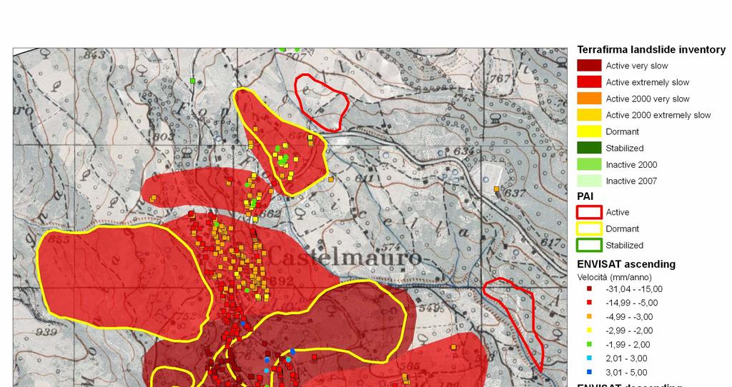
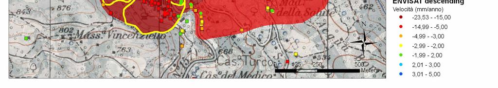


28 Castelmauro New Landslide Activity: modified Boundary: modified New Landslide
29 Guardialfiera: PS ERS


30 Guardialfiera: PS ENVISAT New Landslide Activity: confirmed Boundary: modified New Landslide

31 Terrafirma landslide inventory

32 Terrafirma landslide inventory database - Geometric boundary - Data origin - State of activity - N PS ERS and ENVISAT - Velocity statistical data
33 Terrafirma Inventory results The final database consists of 3093 landslides 261 of which (8,5%) have been modified or added by means PS information Number of landslides Landslides interested area (km²) New landslides 95 10,3 Confirmed landalsides 17 2,8 Modified landslide activity 32 4,8 Modified boundaries 81 27,6 Modified boundaries and activity 36 5,1 By number new landslides By area (km²) 13,8% 36,4% confirmed changed activity 10,0% 20,3% 5,6% 31,0% 12,3% 6,5% changed boundaries changed boundaries and activity 54,6% 9,5%


34 LSM: GORGOGLIONE, Italy Basilicata Region: Basilicata Hydrographic basin: Agri Altitude a.s.l.: 820 m m Geology: Gorgolgione Flysch (Tortonian siliciclastic turbidite formation) villages affected: 1 citizens: Type: earth slides State of activity: active Dimension: 0.33 km 2
35 Gorgoglione Landslide Gorgoglione is affected by an ancient landslide, re-activated during the Irpinia earthquake (1980). An acceleration of the ground movements between late 2003 and the summer 2004 induced the evacuation and the demolition of several buildings. Field surveys (National Group for Geo-hydrological Disaster Prevention of the Italian funded by the CPA), highlighted the presence of a general slope instability in the portion of the village located below Piazza Zanardelli. After the acceleration in situ instrumentations has been installed by the Gorgoglione municipality, but the causes of the slope movements are still under investigation.


36 Damages Damaged pavement and repaired works in the main square
 (1992-2000) 23 images ENVISAT ascending")
37 Gorgoglione: InSAR Data APSA Investigated area: 0.33 km images ERS (44 ascending 84 descending) ( ) 23 images ENVISAT ascending ( ) Data processing by TeleRilevamento Europa


38 Datasets ERS-ENVISAT Department of Earth Sciences CENTRE OF COMPETENCE OF THE CIVIL PROTECTION DEPARTMENT PRESIDENCY OF THE COUNCIL OF MINISTERS Hazard map Very high High Medium Low Data processing by TRE


39 PSI analysis Hazard map Very high High Medium Low The PSI analysis performed confirm the above information highlighting the presence of ground displacement perfectly correspondent to the portion where damages were registered

40 Results of PSI analysis PS analysis has allowed to redraw correctly the landslide boundaries, in particular to define the landslide crowns. Is evident a clear line of demarcation between PS with null velocity and PS with high velocity values.
41 20,00 0,00-20,00-40,00-60,00-80,00-100,00-120,00-140,00-160,00-180,00-200,00 Time Series: ERS - ENVISAT ERS ascending (A08F5) ENVISAT ascending (A2FW4) no data 23/05/ /08/ /11/ /02/ /04/ /07/ /10/ /01/ /04/ /06/ /09/ /12/ /03/2007 displacement (mm) ERS V = - 13,14 mm/y ENVISAT V = - 22,01 mm/y


42 Comparison with Topographic Data Vertical displacement Topographic levelling (nov 2004-may 2005) Average vertical displacement = 8.6 mm
43 Time Series ENVISAT vs Topographic Data Envisat ascending Code A2FPY 0,00-10,00-20,00-30,00 Topographic levelling Vertical component of ENVISAT acquisition V = mm/y Average displacement of topographic levelling = 8.66 mm ( v = 15,0 mm/y ) -40,00-50,00-60,00 V = mm/y -70,00-80,00 14/11/2007 displacement (mm) 10/12/ /06/ /01/ /11/ /08/ /04/ /02/ /09/ /03/ /10/ /04/2007


44 Geologic section - InSAR data analysis The upper part of the slope is characterized by the presence of a clear line of demarcation between PS with null velocity and PS with high velocity values. This suggest an advancing phenomenon without any retrogressive activity; the information is consistent with the geological cross section and with the slope instability behaviour since its re-activation in m 800 m 750 m 0 velocity (mm/y) Envisat ascending ERS descending ERS ascending
45 User s role FROM the definition/validation of the PRODUCTS TO the definition/validation of the SERVICE User as a PRODUCT co-designer Site selection requirements User as a SERVICE observer, tester & validator
46 User s evaluation What applications Practical benefits BENEFITS Decision process? How much is saved?
47 User s feedback For what applications would you use Terrafirma products? What are the practical benefits of Terrafirma products? The product can be used following emergencies induced by landslides to understand the general stability conditions of the area before the event, or as a basic information layer to be used along with other thematic layers to carry out field surveys following requests coming from local or regional authorities for the joint analysis of risk situations induced by slope instability considered as national priorities. The product can be also used for a better definition of the civil protection plans at inter-municipal level. The knowledge of past ground movements using quantitative measurements over wide areas represents a fundamental benefit for our activity. In particular, the added value of using PSI in the estimation of the state of activity of landslides based on a pretty good temporal interval (15 years) is impressive (no other techniques can provide an instrumental and objective measurements over a so large number of points and over wide regions).
48 User s feedback What decision making process could it help? How much could you save by using Terrafirma products? A better identification of the boundaries of unstable areas, especially in urban sectors of the slope, and of their state of activity improves the quality of the emergency plans. In order to obtain over basin and regional scale areas, ground displacement measurements, we should install a few thousands inclinometric tubes or geodetic benchmarks, with high costs in the installation and in the following measurement acquisition.
49 Conclusions Results confirm the capabilities of multi-interferometric InSAR data, integrated with conventional techniques and field surveys, to support landslide investigation at regional and slope scale. Considering the damages related to the landslide activity and the difficulties in the detection of the active, slow and dormant part of the landslide, especially over urban areas, the use of an InSAR approach can positively impact on the current hazard mitigation activities along national and local authorities. A next step is to tailor the service to new EO missions (Sentinel 1, Terrasar-X, CosmoSky Med).

50 THANK YOU FOR THE ATTENTION
Objectives and hypotheses. Remote sensing: applications for landslide hazard assessment and risk management. Ping Lu (University of Firenze) Methods
 Methods") Topical Workshop Remote sensing: applications for landslide hazard assessment and risk management Ping Lu (University of Firenze) Supervisors: Prof. Nicola Casagli; Prof. Filippo Catani (Unifi) Dr. Veronica
Topical Workshop Remote sensing: applications for landslide hazard assessment and risk management Ping Lu (University of Firenze) Supervisors: Prof. Nicola Casagli; Prof. Filippo Catani (Unifi) Dr. Veronica
Pilot service: Southern Emilia Romagna (Italy)
") Pilot service: Southern Emilia Romagna (Italy) Surface deformation service provider (PSInSAR TM ) Geodetic and optical remote sensing data integration Final user The study area The Southern Emilia-Romagna
Pilot service: Southern Emilia Romagna (Italy) Surface deformation service provider (PSInSAR TM ) Geodetic and optical remote sensing data integration Final user The study area The Southern Emilia-Romagna
ESA GMES: Terrafirma S3: Service Prospectus V4.4 June 2013 GMES TERRAFIRMA. ESRIN/Contract no / 05 / I-EC. S3: Service Prospectus
 GMES TERRAFIRMA ESRIN/Contract no. 19366 / 05 / I-EC S3: Service Prospectus Version 4.4 June 14 th 2013 Geraint Cooksley, Chris Bremmer, Salvatore Stramondo & Gaia Righini Reviewed by: Project Manager
EO Information Services. Assessing Vulnerability in the metropolitan area of Rio de Janeiro (Floods & Landslides) Project
 Project") EO Information Services in support of Assessing Vulnerability in the metropolitan area of Rio de Janeiro (Floods & Landslides) Project Ricardo Armas, Critical Software SA Haris Kontoes, ISARS NOA World
EO Information Services in support of Assessing Vulnerability in the metropolitan area of Rio de Janeiro (Floods & Landslides) Project Ricardo Armas, Critical Software SA Haris Kontoes, ISARS NOA World
The PREVIEW project: general objectives and an overview of the landslides platform
 The PREVIEW project: general objectives and an overview of the landslides platform Risk Mitigation for Earthquakes and Landslides Giacomo Falorni Earth Sciences Dept. University of Firenze 19-20 July 2007
Dr. Simon Plank. German Remote Sensing Data Center (DFD), German Aerospace Center (DLR)
, German Aerospace Center (DLR)") Pre-survey suitability analysis of the differential and persistent scatterer synthetic ti aperture radar interferometry t method for deformation monitoring of landslides Dr. Simon Plank German Remote Sensing
Pre-survey suitability analysis of the differential and persistent scatterer synthetic ti aperture radar interferometry t method for deformation monitoring of landslides Dr. Simon Plank German Remote Sensing
Retrieving 3D deformation pattern of a landslide with hiresolution InSAR and in-situ measurements: Just landslide case-study
 Retrieving 3D deformation pattern of a landslide with hiresolution InSAR and in-situ measurements: Just landslide case-study Zbigniew Perski (1), Petar Marinković (2), Yngvar Larsen (3), Tomasz Wojciechowski
Continuous Risk Assessment of Structures and Plants in Areas of Ground Deformation Susceptibility by Space-based SAR/ASAR Interferometry
 CCN4 Project Continuous Risk Assessment of Structures and Plants in Areas of Ground Deformation Susceptibility by Space-based SAR/ASAR Interferometry Issaak Parcharidis*, Michael Foumelis and Penelope
Interpretive Map Series 24
 Oregon Department of Geology and Mineral Industries Interpretive Map Series 24 Geologic Hazards, and Hazard Maps, and Future Damage Estimates for Six Counties in the Mid/Southern Willamette Valley Including
EO Information Services in support of Satellite Tools for Building Flood Defence Systems in Guyana
 EO Information Services in support of Satellite Tools for Building Flood Defence Systems in Guyana F. N. Koudogbo and A. Arnaud Altamira Information J. Leen, Eurosense World Bank HQ, Washington DC Date
Innovative Ways to Monitor Land Displacement
 ARTICLE Innovative Ways to Monitor Land Displacement When people think about landslides, they usually imagine large mud streams which cause considerable loss of life. Whereas such large-scale disasters
Improved PSI Performance for Landslide Monitoring Applications. J. Duro, R. Iglesias, P. Blanco-Sánchez, F. Sánchez and D. Albiol
 Improved PSI Performance for Landslide Monitoring Applications J. Duro, R. Iglesias, P. Blanco-Sánchez, F. Sánchez and D. Albiol Outline Area of Study Previous PSI (and others) studies Main conclusions
SAR APPLICATIONS IN GREECE With emphasis for Harokopio University/ Dep. of Geography activities
 SAR APPLICATIONS IN GREECE With emphasis for Harokopio University/ Dep. of Geography activities Issaak Parcharidis, Assist. Prof. Harokopio University of Athens Department of Geography parchar@hua.gr 4
PERSISTENT SCATTERER INTERFEROMETRY: POTENTIAL AND LIMITS
 PERSISTENT SCATTERER INTERFEROMETRY: POTENTIAL AND LIMITS M. Crosetto a, O. Monserrat a, A. Jungner, B. Crippa b a Institute of Geomatics, Av. del Canal Olímpic, s/n, Castelldefels, E-08860, Spain (michele.crosetto,
EMERGENCY PLANNING IN NORTHERN ALGERIA BASED ON REMOTE SENSING DATA IN RESPECT TO TSUNAMI HAZARD PREPAREDNESS
 EMERGENCY PLANNING IN NORTHERN ALGERIA BASED ON REMOTE SENSING DATA IN RESPECT TO TSUNAMI HAZARD PREPAREDNESS Barbara Theilen-Willige Technical University of Berlin, Institute of Applied Geosciences Department
Progress Report Form of WCoEs 2014
 Date of Submission 25/02/2015 Progress Report Form of WCoEs 2014 3 June 2014 to 31 December 2014 1. Short Title of WCoE: Advanced Technologies for LandSlides (ATLaS) 2. Name of Institution (Name of leader
THE USE OF DIFFERENT REMOTE SENSING TECHNIQUES FOR LANDSLIDE CHARACTERIZATION
 THE USE OF DIFFERENT REMOTE SENSING TECHNIQUES FOR LANDSLIDE CHARACTERIZATION Ph.D. candidate: ANNA DE AGOSTINI Tutor: Dr. M. FLORIS Cycle: XXVI Abstract The aim of my research is to investigate the potential
Application of PSI technique to slope stability monitoring in the Daunia mountains, Italy
 ESA ESRIN - Frascati 28 November- 2 December Application of PSI technique to slope stability monitoring in the Daunia mountains, Italy F. Bovenga (1) (fabio.bovenga@ba.infn.it) L. Guerriero (1) R. Nutricato
Spanish national plan for land observation: new collaborative production system in Europe
 ADVANCE UNEDITED VERSION UNITED NATIONS E/CONF.103/5/Add.1 Economic and Social Affairs 9 July 2013 Tenth United Nations Regional Cartographic Conference for the Americas New York, 19-23, August 2013 Item
LANDSLIDE IDENTIFICATION, MOVEMENT MONITORING AND RISK ASSESSMENT USING ADVANCED EARTH OBSERVATION TECHNIQUES
 LANDSLIDE IDENTIFICATION, MOVEMENT MONITORING AND RISK ASSESSMENT USING ADVANCED EARTH OBSERVATION TECHNIQUES European Leader Investigator Dr. Zbigniew Perski Carpathian Branch, Polish Geological Institute
The Safeland Project General Overview and Monitoring Technology Development
 Ber. Geol. B. A., 82, ISSN 1017 8880 Landslide Monitoring Technologies & Early Warning Systems The Safeland Project General Overview and Monitoring Technology Development The SafeLand Consortium a), N.
Airbus DS Consortium Risk and Recovery. Airbus DS Corporate Presentation
 Airbus DS Consortium Risk and Recovery 1 January, 2017 Airbus DS Corporate Presentation 2 SERTIT s Copernicus EMS mapping service Risk & Recovery and Rapid Mapping Based on our 24/7/365 operational rapid
Università di Roma La Sapienza, Facoltà d Ingegneria, Dipartimento di Idraulica,Trasporti e Strade (D.I.T.S.) 00185, Roma, Italy
 00185, Roma, Italy") DORIS FP7-EU PROJECT: EXPLOITATION OF 20 YEARS DINSAR DATA ARCHIVE FOR LANDSLIDE MONITORING Manunta M. (1), Calò F. (1), Paglia L., (1), Bonano M. (1,2), Lanari R. (1) (1) IREA-CNR, Via Diocleziano 328,
DORIS FP7-EU PROJECT: EXPLOITATION OF 20 YEARS DINSAR DATA ARCHIVE FOR LANDSLIDE MONITORING Manunta M. (1), Calò F. (1), Paglia L., (1), Bonano M. (1,2), Lanari R. (1) (1) IREA-CNR, Via Diocleziano 328,
Manitoba s Elevation (LiDAR) & Imagery Datasets. Acquisition Plans & Opportunities for Collaboration
 & Imagery Datasets. Acquisition Plans & Opportunities for Collaboration") Manitoba s Elevation (LiDAR) & Imagery Datasets Acquisition Plans & Opportunities for Collaboration Manitoba Planning Conference May 2017 Presentation Outline Manitoba s Elevation (LiDAR) and Imagery Datasets
Manitoba s Elevation (LiDAR) & Imagery Datasets Acquisition Plans & Opportunities for Collaboration Manitoba Planning Conference May 2017 Presentation Outline Manitoba s Elevation (LiDAR) and Imagery Datasets
Georeferencing and Satellite Image Support: Lessons learned, Challenges and Opportunities
 Georeferencing and Satellite Image Support: Lessons learned, Challenges and Opportunities Shirish Ravan shirish.ravan@unoosa.org UN-SPIDER United Nations Office for Outer Space Affairs (UNOOSA) UN-SPIDER
ZRCSAZU. Remote sensing and Earth observation data at ZRC SAZU. dr. Tatjana Veljanovski Atrij ZRC Ljubljana
 ZRCSAZU Remote sensing and Earth observation data at ZRC SAZU dr. Tatjana Veljanovski 2016-06-08 Atrij ZRC Ljubljana Remote Sensing Department Remote Sensing Department 20 years of experience application,
Terrafirma Extension Tectonic Theme. 6 th Terrafirma Workshop ESA-ESRIN, December 1st, 2010
 Terrafirma Extension Tectonic Theme 6 th Terrafirma Workshop ESA-ESRIN, December 1st, 2010 Summary - Service Prospectus Presentation - The Terrafirma Extension Tectonic Theme (TFX-TT) - Greek Task Force
AND THE COOPERATION WITH SENTINEL ASIA FOR DISASTER MANAGEMENT
 Ministry of Natural resources and Environment National Remote Sensing DEpartment NATIONAL REMOTE SENSING DEPARTMENT (NRSD) AND THE COOPERATION WITH SENTINEL ASIA FOR DISASTER MANAGEMENT By: Dr. Chu Hai
Objectives. to map land subsidence at a basin scale through spaceborne
 Dipartimento di Scienze della Terra www.geo.unifi.it Tele-Rilevamento Europa TRE, a POLIMI spin-off company Land subsidence mapping and monitoring through PSInSAR: examples from the Arno river basin (Italy)
Landslide Hazard Assessment Methodologies in Romania
 A Scientific Network for Earthquake, Landslide and Flood Hazard Prevention SciNet NatHazPrev Landslide Hazard Assessment Methodologies in Romania In the literature the terms of susceptibility and landslide
VALIDATION OF THE PERMANENT SCATTERERS TECHNIQUE IN URBAN AREAS
 VALIDATION OF THE PERMANENT SCATTERERS TECHNIQUE IN URBAN AREAS Alessandro Ferretti, Claudio Prati, Fabio Rocca, Carlo Colesanti Dipartimento di Elettonica e Informazione Politecnico di Milano Piazza L.
March 2007 The Survey Department of Sri Lanka
 Contribution of Survey Department of Sri Lanka for Mitigation of Disasters in Sri Lanka K.A.U.N.Kasthuri Deputy Surveyor General (Information Technology) March 2007 The Survey Department of Sri Lanka 1
CEOS WG Disasters Report
 Committee on Earth Observation Satellites CEOS WG Disasters Report Stéphane Chalifoux SIT Tech Workshop 2016 Agenda Item # 16 CEOS Strategic Implementation Team Tech Workshop Oxford, UK 14 th -15 th September
Deformation measurement using SAR interferometry: quantitative aspects
 Deformation measurement using SAR interferometry: quantitative aspects Michele Crosetto (1), Erlinda Biescas (1), Ismael Fernández (1), Ivan Torrobella (1), Bruno Crippa (2) (1) (2) Institute of Geomatics,
Preparing Landslide Inventory Maps using Virtual Globes
 Introduction: A landslide is the movement of a mass of rock, debris, or earth down a slope, under the influence of gravity. Landslides can be caused by different phenomena, including intense or prolonged
A METHODOLOGY FOR ASSESSING EARTHQUAKE-INDUCED LANDSLIDE RISK. Agency for the Environmental Protection, ITALY (
 A METHODOLOGY FOR ASSESSING EARTHQUAKE-INDUCED LANDSLIDE RISK Roberto W. Romeo 1, Randall W. Jibson 2 & Antonio Pugliese 3 1 University of Urbino, ITALY (e-mail: rwromeo@uniurb.it) 2 U.S. Geological Survey
Volcanoes Session. Chairs: Y. Fukushima & G. Puglisi
 Volcanoes Session Chairs: Y. Fukushima & G. Puglisi Presentation Summary We had presentations on volcanoes all over the world, more than the last FRINGE workshops: Etna, Campi Flegrei, Ethiopian rift,
Supplement of Brief Communication: Rapid mapping of landslide events: the 3 December 2013 Montescaglioso landslide, Italy
 Supplement of Nat. Hazards Earth Syst. Sci., 14, 1835 1841, 2014 http://www.nat-hazards-earth-syst-sci.net/14/1835/2014/ doi:10.5194/nhess-14-1835-2014-supplement Author(s) 2014. CC Attribution 3.0 License.
Outline. Remote Sensing, GIS and DEM Applications for Flood Monitoring. Introduction. Satellites and their Sensors used for Flood Mapping
 Outline Remote Sensing, GIS and DEM Applications for Flood Monitoring Prof. D. Nagesh Kumar Chairman, Centre for Earth Sciences Professor, Dept. of Civil Engg. Indian Institute of Science Bangalore 560
Two case history of EMS data application: earthquake in central italy and flooding in Piedmont region
 Two case history of EMS data application: earthquake in central italy and flooding in Piedmont region Luca Lanteri*, Rocco Pispico*, R. Cremonini** *Arpa Piemonte, Geological and Natural Risk Dipartiment
SPATIAL MODELS FOR THE DEFINITION OF LANDSLIDE SUSCEPTIBILITY AND LANDSLIDE HAZARD. J.L. Zêzere Centre of Geographical Studies University of Lisbon
 SPATIAL MODELS FOR THE DEFINITION OF LANDSLIDE SUSCEPTIBILITY AND LANDSLIDE HAZARD J.L. Zêzere Centre of Geographical Studies University of Lisbon CONCEPTUAL MODEL OF LANDSLIDE RISK Dangerous Phenomena
Space for Smarter Government Programme
 Space for Smarter Government Programme Development of Operational National Satellite Imaging Flood Mapping Capability Project Number: 59287-454144 Web: http://www.spaceforsmartergovernment.uk/ Email: ssgp@sa.catapult.org.uk
Earth Observation for Emergency Response and the International Charter on Space and Major Disasters.
 Earth Observation for Emergency Response and the International Charter on Space and Major Disasters. Case studies of the 2016 Alberta wildfires and 2017 Québec flooding Simon Tolszczuk-Leclerc 1, Brad
Emergency preparedness tools for landslides
 http://omiv.unistra.fr Emergency preparedness tools for landslides A. Remaître, J.-P. Malet, S. Sterlacchinni, A. Pasuto Institut de Physique du Globe, Université de Strasbourg, Strasbourg, France CERG,
Effect of land cover / use change on soil erosion assessment in Dubračina catchment (Croatia)
") European Water 57: 171-177, 2017. 2017 E.W. Publications Effect of land cover / use change on soil erosion assessment in Dubračina catchment (Croatia) N. Dragičević *, B. Karleuša and N. Ožanić Faculty
European Water 57: 171-177, 2017. 2017 E.W. Publications Effect of land cover / use change on soil erosion assessment in Dubračina catchment (Croatia) N. Dragičević *, B. Karleuša and N. Ožanić Faculty
SLOPE STABILITY MONITORING USING SPACE-BORNE REPEAT- PASS SAR INTERFEROMETRY
 SLOPE STABILITY MONITORING USING SPACE-BORNE REPEAT- PASS SAR INTERFEROMETRY Urs WEGMÜLLER 1, Charles WERNER 1, Tazio STROZZI 1, Andreas WIESMANN 1, and Hugo RAETZO 2 1 Gamma Remote Sensing AG, Switzerland
SAR interferometry Status and future directions. Rüdiger Gens
 SAR interferometry Status and future directions Rüdiger Gens Polarimetric InSAR Polarimetric InSAR InSAR - Status and future directions sensitivity to changes in surface scattering, even in the presence
Involvement of the Geological Survey of Slovenia in the field of natural hazard risk management
 Involvement of the Geological Survey of Slovenia in the field of natural hazard risk management Špela Kumelj, Mateja Jemec-Auflič, Jernej Jež, Tina Peternel, Blaž Milanič Geohazard group, GeoZS COMLAND
1. INTRODUCTION. EXAMPLE OF SECHILIENNE ROCKFALL (France)
") FORM OSE POST-GRADUATE COURSE Landslide vulnerability and risk 1 FORM OSE POST-GRADUATE COURSE Landslide vulnerability and risk 2 FORM OSE POST-GRADUATE COURSE Landslide vulnerability and risk 3 Christophe
FORM OSE POST-GRADUATE COURSE Landslide vulnerability and risk 1 FORM OSE POST-GRADUATE COURSE Landslide vulnerability and risk 2 FORM OSE POST-GRADUATE COURSE Landslide vulnerability and risk 3 Christophe
ANALYSIS OF VERTICAL MOVEMENTS DETECTED BY RADAR INTERFEROMETRY IN URBAN AREAS
 10TH CZECH-POLISH WORKSHOP ON RECENT GEODYNAMICS OF THE SUDETEN AND ADJACENT AREAS Szklarska Poręba, Poland, November 5 7, 2009 ANALYSIS OF VERTICAL MOVEMENTS DETECTED BY RADAR INTERFEROMETRY IN URBAN
IPL Project (IPL - 196) Annual Report Form 2017
 Annual Report Form 2017") Date of Submission 26/03/2017 IPL Project (IPL - 196) Annual Report Form 2017 1 January 2016 to 31 December 2016 1. Project Number (approved year) and Title, IPL-196 (2015) Development and applications
Date of Submission 26/03/2017 IPL Project (IPL - 196) Annual Report Form 2017 1 January 2016 to 31 December 2016 1. Project Number (approved year) and Title, IPL-196 (2015) Development and applications
GMES EURORISK Geo-information services for natural and man-made risks management
 GMES EURORISK Geo-information services for natural and man-made risks management 8/11/2004 EURORISK A European scale approach for developing, delivering and operationally exploiting new information services
Copernicus Overview and Emergency Management Service
 Copernicus Overview and Emergency Management Service Frédéric BASTIDE European Commission Open informal session of the United Nations Inter-Agency Meeting on Outer Space Activities 12 March 2013, Geneva
Castaldo R. (1) De Novellis V. (1) Lollino P. (2) Manunta M. (1) Tizzani P. (1) 1: IREA-CNR, Napoli, Italy. 2: IRPI-CNR, Bari, Italy.
 De Novellis V. (1) Lollino P. (2) Manunta M. (1) Tizzani P. (1) 1: IREA-CNR, Napoli, Italy. 2: IRPI-CNR, Bari, Italy.") Advanced Numerical Modelling for Slow Landslide Analyses through the Effective Integration of SBAS-DInSAR and in situ Observations: the Case Study of Ivancich Landslide (Assisi, Italy) Castaldo R. (1)
Advanced Numerical Modelling for Slow Landslide Analyses through the Effective Integration of SBAS-DInSAR and in situ Observations: the Case Study of Ivancich Landslide (Assisi, Italy) Castaldo R. (1)
Remote sensing data uses and supply in Vietnam. Dr. Chu Hải Tùng National Remote Sensing Department, Ministry of Natural Resource and Environment
 Remote sensing data uses and supply in Vietnam Dr. Chu Hải Tùng National Remote Sensing Department, Ministry of Natural Resource and Environment Content Uses of remote sensing data in Vietnam Roles of
Transactions on Information and Communications Technologies vol 18, 1998 WIT Press, ISSN
 Ready-to-use GIS information from remotely sensed data G. Sylos Labini*, S. Samarelli*, G. Pasquariello^ G. Nico*, A. Refice* & J. Bequignon ' Planetek Italia, Tecnopolis, 70010 Valenzano, Bari, Italy
Compact guides GISCO. Geographic information system of the Commission
 Compact guides GISCO Geographic information system of the Commission What is GISCO? GISCO, the Geographic Information System of the COmmission, is a permanent service of Eurostat that fulfils the requirements
THE 3-REGIONS WORKING GROUP SLOPE INSTABILITIES (SlopeIn)
") Bayerisches Landesamt für Umwelt THE 3-REGIONS WORKING GROUP SLOPE INSTABILITIES (SlopeIn) COMMON LANGUAGE, COMPARABLE HAZARD MAPPING AND SHARED EXPERIENCES ACROSS EUROPE The 3-Regions Working-Group SlopeIn:
Bayerisches Landesamt für Umwelt THE 3-REGIONS WORKING GROUP SLOPE INSTABILITIES (SlopeIn) COMMON LANGUAGE, COMPARABLE HAZARD MAPPING AND SHARED EXPERIENCES ACROSS EUROPE The 3-Regions Working-Group SlopeIn:
Data Origin. How to obtain geodata? Ron van Lammeren CGI-GIRS 0910
 Data Origin How to obtain geodata? Ron van Lammeren CGI-GIRS 0910 Spatial Data interest Improvement of policy making. ± 90% of all information used by government has spatial characteristics SPATIAL INFORMATION
INCA CE: Integrating Nowcasting with crisis management and risk prevention in a transnational framework
 INCA CE: Integrating Nowcasting with crisis management and risk prevention in a transnational framework Yong Wang ZAMG, Austria This project is implemented through the CENTRAL EUROPE Programme co-financed
Copernicus Overview. Major Emergency Management Conference Athlone 2017
 Copernicus Overview Major Emergency Management Conference Athlone 2017 Copernicus is a European programme implemented by the European Commission. The services address six thematic areas: land, marine,
GEO-VIII November Geohazard Supersites and Natural Laboratories Progress Report. Document 9
 GEO-VIII 16-17 November 2011 Geohazard Supersites and Natural Laboratories Progress Report Document 9 This document is submitted to GEO-VIII for information. Geohazard Supersites and Natural Laboratories
Landslide Susceptibility, Hazard, and Risk Assessment. Twin Hosea W. K. Advisor: Prof. C.T. Lee
 Landslide Susceptibility, Hazard, and Risk Assessment Twin Hosea W. K. Advisor: Prof. C.T. Lee Date: 2018/05/24 1 OUTLINE INTRODUCTION LANDSLIDE HAZARD ASSESSTMENT LOGISTIC REGRESSION IN LSA STUDY CASE
COMPREHENSIVE GIS-BASED SOLUTION FOR ROAD BLOCKAGE DUE TO SEISMIC BUILDING COLLAPSE IN TEHRAN
 COMPREHENSIVE GIS-BASED SOLUTION FOR ROAD BLOCKAGE DUE TO SEISMIC BUILDING COLLAPSE IN TEHRAN B. Mansouri 1, R. Nourjou 2 and K.A. Hosseini 3 1 Assistant Professor, Dept. of Emergency Management, International
A COMPREHENSIVE ANALYSIS OF THE CAPABILITES AND LIMITATIONS OF PSI
 A COMPREHENSIVE ANALYSIS OF THE CAPABILITES AND LIMITATIONS OF PSI Rachel Holley, InSAR Surveying Consultant InSAR Surveying Team Fugro NPA Satellite Mapping Introduction Look at the capabilities and limitations
NASA Jet Propulsion Laboratory Data Products
 NASA Jet Propulsion Laboratory Data Products 17 April 2014 Emergency Response Spatial Tools Technical Interchange Maggi Glasscoe Margaret.T.Glasscoe@jpl.nasa.gov Sang-Ho Yun Sang-Ho.Yun@jpl.nasa.gov www.nasa.gov
Applying Hazard Maps to Urban Planning
 Applying Hazard Maps to Urban Planning September 10th, 2014 SAKAI Yuko Disaster Management Expert JICA Study Team for the Metro Cebu Roadmap Study on the Sustainable Urban Development 1 Contents 1. Outline
CNES R&D and available software for Space Images based risk and disaster management
 CNES R&D and available software for Space Images based risk and disaster management 1/21 Contributors: CNES (Centre National d Etudes Spatiales), Toulouse, France Hélène Vadon Jordi Inglada 2/21 Content
USING SAR INTERFEROGRAMS AND COHERENCE IMAGES FOR OBJECT-BASED DELINEATION OF UNSTABLE SLOPES
 USING SAR INTERFEROGRAMS AND COHERENCE IMAGES FOR OBJECT-BASED DELINEATION OF UNSTABLE SLOPES Barbara Friedl (1), Daniel Hölbling (1) (1) Interfaculty Department of Geoinformatics Z_GIS, University of
Land Use / Land Cover Mapping in
 Land Use / Land Cover Mapping in Eastern and Southern African Regions RCMRD Experience by 6/24/2013, Nairobi Kenya Dr. Tesfaye Korme Director of RS, GIS and Mapping, RCMRD I. About RCMRD, Its Vision and
PROANA A USEFUL SOFTWARE FOR TERRAIN ANALYSIS AND GEOENVIRONMENTAL APPLICATIONS STUDY CASE ON THE GEODYNAMIC EVOLUTION OF ARGOLIS PENINSULA, GREECE.
 PROANA A USEFUL SOFTWARE FOR TERRAIN ANALYSIS AND GEOENVIRONMENTAL APPLICATIONS STUDY CASE ON THE GEODYNAMIC EVOLUTION OF ARGOLIS PENINSULA, GREECE. Spyridoula Vassilopoulou * Institute of Cartography
Statewide Topographic Mapping Program
 Statewide Topographic Mapping Program February 28, 2018 www.dotd.la.gov Outline Purpose of the Statewide Topographic Mapping Program History Breakdown of R.S. 48:36 - Topographic Mapping Statewide Topographic
Geo-hazard Potential Mapping Using GIS and Artificial Intelligence
 Geo-hazard Potential Mapping Using GIS and Artificial Intelligence Theoretical Background and Uses Case from Namibia Andreas Knobloch 1, Dr Andreas Barth 1, Ellen Dickmayer 1, Israel Hasheela 2, Andreas
Philippines NSDI Foundation Data Program. Andrew Bashfield
 Philippines NSDI Foundation Data Program Andrew Bashfield 1 Overview Part 1: Building the NSDI Framework Part 2: Collecting Foundation Datasets 2 Building the NSDI Framework Background & NDSI Overview
Data Origin. Ron van Lammeren CGI-GIRS 0910
 Data Origin Ron van Lammeren CGI-GIRS 0910 How to obtain geodata? Geo data initiative Executive Order 12906, "Coordinating Geographic Data Acquisition and Access: The National Spatial Data Infrastructure,"
International Conference Analysis and Management of Changing Risks for Natural Hazards November 2014 l Padua, Italy
 Abstract Code: B01 Assets mapping products in support of preparedness and prevention measures (examples from Germany, Italy and France) Marc Mueller, Thierry Fourty, Mehdi Lefeuvre Airbus Defence and Space,
NGIAs' roles in successful disaster response
 The Second UN-GGIM-AP Plenary Meeting NGIAs' roles in successful disaster response Japan Teheran Iran 28 October 2013 Shin-ichi SAKABE, Director of International Affairs Division Geospatial Information
Subsidence and associated shallow faulting hazard assessment in central Mexico using InSAR and GPS.
 Subsidence and associated shallow faulting hazard assessment in central Mexico using InSAR and GPS. E. Cabral-Cano, Instituto de Geofísica, UNAM D. Solano-Rojas, Univ. of Miami-RSMAS T. Oliver-Cabrera
Roles of NGII in successful disaster management
 The Second UN-GGIM-AP Plenary Meeting Roles of NGII in successful disaster management Republic of Korea Teheran Iran 28 October 2013 Sanghoon Lee, Ph.D. NGII Outline Type of Disasters Occur in Korea Practical
The financial and communal impact of a catastrophe instantiated by. volcanoes endlessly impact on lives and damage expensive infrastructure every
 Chapter 1 Introduction The financial and communal impact of a catastrophe instantiated by geophysical activity is significant. Landslides, subsidence, earthquakes and volcanoes endlessly impact on lives
RESAP Progress Report
 RESAP Progress Report December 2016 to October 2017 Presentation to the Twenty-first session of the Intergovernmental Consultative Committee on the Regional Space Applications Programme for Sustainable
GEOMATICS. Shaping our world. A company of
 GEOMATICS Shaping our world A company of OUR EXPERTISE Geomatics Geomatics plays a mayor role in hydropower, land and water resources, urban development, transport & mobility, renewable energy, and infrastructure
Portfolio of karteco Cadastral Survey Department
 Portfolio of karteco Cadastral Survey Department 01-2016 Who we are? karteco Environmental & Energy Engineering Consultancy Founding members: Apostolos Karteris Dr. Environmental Engineer Marinos Karteris
Application of satellite InSAR data for hydrocarbon reservoir monitoring
 Application of satellite InSAR data for hydrocarbon reservoir monitoring A. Tamburini, A. Belson, A. Ferretti, F. Novali TRE Milano, Italy Copyright - Tele-Rilevamento Europa - 2004 Outline SqueeSAR TM
The Safety project: Updating geohazard activity maps with Sentinel-1data
 The Safety project: Updating geohazard activity maps with Sentinel-1data Oriol Monserrat a, Safety Consortium a Centre Tecnològic de Telecomunicacions de Catalunya (CTTC/CERCA), Division of Geomatics,
Sustainable and Harmonised Development for Smart Cities The Role of Geospatial Reference Data. Peter Creuzer
 Sustainable and Harmonised Development for Smart Cities The Role of Geospatial Reference Data Peter Creuzer 1. Introduction - Smart Cities and Geodata 2. Geodata in Germany 3. Examples 4. Data and Service
MISSOURI LiDAR Stakeholders Meeting
 MISSOURI LiDAR Stakeholders Meeting East-West Gateway June 18, 2010 Tim Haithcoat Missouri GIO Enhanced Elevation Data What s different about it? Business requirements are changing.fast New data collection
Progress Report. Flood Hazard Mapping in Thailand
 Progress Report Flood Hazard Mapping in Thailand Prepared By: Mr. PAITOON NAKTAE Chief of Safety Standard sub-beuro Disaster Prevention beuro Department of Disaster Prevention and Mitigation THAILAND E-mail:
Central Asian Institute for Applied Geosciences: one year with Sentinel Asia
 Central Asian Institute for Applied Geosciences: one year with Sentinel Asia http://www.caiag.kg Dr. B.Moldobekov DPN and JPTM 2010 for Sentinel Asia STEP-2 5-8 July 2010, Manila, Philippines Concept of
I&CLC2000 in support to new policy initiatives (INSPIRE, GMES,..)
") I&CLC2000 in support to new policy initiatives (INSPIRE, GMES,..) Manfred Grasserbauer, Director Joint Research Centre Institute for Environment and Sustainability 1 IMAGE 2000 European mosaic of satellite
I&CLC2000 in support to new policy initiatives (INSPIRE, GMES,..) Manfred Grasserbauer, Director Joint Research Centre Institute for Environment and Sustainability 1 IMAGE 2000 European mosaic of satellite
Coastal cliffs hazard Natural and human-induced hazards. Stefano FURLANI, Stefano DEVOTO Department of Mathematics and Geosciences
 Coastal cliffs hazard Natural and human-induced hazards Stefano FURLANI, Stefano DEVOTO Department of Mathematics and Geosciences Program of the lecture Types of landslides Geohazards Accidents and perception
Copernicus for Raw Materials Workshop
 Copernicus for Raw Materials Workshop Copernicus 40 User Years Forum Listening Industry Workshop, to the Beat 5th September of the Earth 2016, Brussels About http://copernicus.eu/raw-materials-workshop
Use of Geospatial data for disaster managements
 Use of Geospatial data for disaster managements Source: http://alertsystemsgroup.com Instructor : Professor Dr. Yuji Murayama Teaching Assistant : Manjula Ranagalage What is GIS? A powerful set of tools
Roadmap to Stability
 Landslide Policy Committee for Aizawl City February 2014 Technical Support by: Aizawl is in earthquake hazard zone V and highly prone to natural, man-made and earthquake induced landslides. In order to
Persistent Scatterer Interferometry (PSI) Technique for Landslide Characterization and Monitoring
 Technique for Landslide Characterization and Monitoring") Remote Sens. 2013, 5, 1045-1065; doi:10.3390/rs5031045 Article OPEN ACCESS Remote Sensing ISSN 2072-4292 www.mdpi.com/journal/remotesensing Persistent Scatterer Interferometry (PSI) Technique for Landslide
Remote Sens. 2013, 5, 1045-1065; doi:10.3390/rs5031045 Article OPEN ACCESS Remote Sensing ISSN 2072-4292 www.mdpi.com/journal/remotesensing Persistent Scatterer Interferometry (PSI) Technique for Landslide
SEISMIC RISK ASSESSMENT IN ARMENIA
 SEISMIC RISK ASSESSMENT IN ARMENIA Hovhannes Khangeldyan Head of National Crisis Management Center Rescue Service Ministry of Emergency Situations of the Republic of Armenia Tokyo, 2016 ARMENIA: GEOGRAPHICAL
Practical reliability approach to urban slope stability
 University of Wollongong Research Online Faculty of Engineering - Papers (Archive) Faculty of Engineering and Information Sciences 2011 Practical reliability approach to urban slope stability R. Chowdhury
Contribution to the Mountain-Risks project of the Rock Mechanics Laboratory of the Swiss Federal Institute of Technology of Lausanne
 Contribution to the Mountain-Risks project of the Rock Mechanics Laboratory of the Swiss Federal Institute of Technology of Lausanne PhD Student: Jacopo Abbruzzese Supervisor: Dr. Vincent Labiouse MOUNTAIN
RISK ASSESSMENT METHODOLOGIES FOR LANDSLIDES
 RISK ASSESSMENT METHODOLOGIES FOR LANDSLIDES Jean-Philippe MALET Olivier MAQUAIRE CNRS & CERG. Welcome to Paris! 1 Landslide RAMs Landslide RAM A method based on the use of available information to estimate
Geotechnical Risks and Management Systems: An FHWA Perspective
 October 13, 2010 2010 STGE Conference Charleston, WV Geotechnical Risks and Management Systems: An FHWA Perspective Silas C. Nichols, PE, Senior Bridge Engineer - Geotechnical Federal Highway Administration