NGIAs' roles in successful disaster response
|
|
|
- Earl Phillips
- 5 years ago
- Views:
Transcription
 Outline Type of Disasters Occur in Japan Practical Examples for Type of Disasters Mandate Given to NGIA for Disaster Management Practical Examples of Measures")
1 The Second UN-GGIM-AP Plenary Meeting NGIAs' roles in successful disaster response Japan Teheran Iran 28 October 2013 Shin-ichi SAKABE, Director of International Affairs Division Geospatial Information Authority of Japan (GSI) Outline Type of Disasters Occur in Japan Practical Examples for Type of Disasters Mandate Given to NGIA for Disaster Management Practical Examples of Measures Taken for Disaster Management by NGIA Type of Data Developed and Provided Equipment or Technical Methods used by NGIA for Disaster Management. Factors Contributing to Effective Disaster Preparedness by NGIA Users of NGIA s Data and Services Cooperation with Related Communities for Disaster Management Kinds of Data/Services NGIAs Should Deliver to the Communities Role of UN-GGIM-AP in Disaster 1


 Tsunami: - Highest")


2 Type of Disasters Occur in Japan Earthquake Tsunami Volcanic Eruption Flood Landslide Storm Heavy Rain Heavy Snow Tornado Like a shopping mall Practical Example for Earthquake - the Great East Japan Earthquake on March 11 th, 2011 Earthquake: - Mw: Ground surface movement (max): 5.3m (horizontal), -1.2m (vertical) Tsunami: - Highest elevation reached: 43m - Inundated areas: 561 square km (approx. 10 times of the Manhattan Island in New York) - 15,883 people dead, 2,654 people missing Land Slide Liquefaction Damage 2
3 Mandate Given to NGIA for Disaster Management Basic Act on Disaster Control Measures - To protect land and property of the country/people from hazards by making necessary institutional arrangements and other measures including financial provisions - 24 designated organizations in the Government including GSI mandated to develop and implement disaster prevention plan mandated to gather and share information on disasters, while maximizing the use of geospatial information. Amended after 3.11 Earthquake Practical Examples of Measures Taken for Disaster Management by NGIA What GSI did at 3.11 Earthquake in Emergency Response Phase Provision of maps of affected areas - Immediately (< 1h) provide to Government offices starting from smallscale maps (1:500k) Detection and analysis of ground surface movement with GNSS control point network Aerial Survey (Aerial photos + Ortho images) - Photo interpretation and measurement of damaged areas 3
4 Practical Examples of Measures Taken for Disaster Management by NGIA What GSI did at 3.11 Earthquake in Recovery Phase(+1-2 months -) Resurvey for new coordinates of geodetic control points - Resurvey of horizontal and leveling control points - Revision of coordinates of control point network origins (horizontal & vertical) - Distributing survey results of control points New mapping of damaged areas - 1:2,500 scale mapping for reconstruction planning Type of Data Developed and Provided Base Maps (paper and digital) Data of Ground Surface Movement with GNSS Control Point Network Aerial Photos and Ortho Images Disaster Overview Maps Thematic Maps (e.g. Tsunami Inundation Mapping) Correction Parameters for Horizontal Control Points Recovery Planning Maps 4
 GNSS based control")

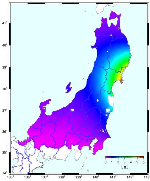
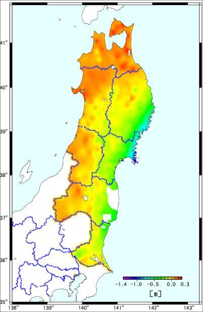
5 Provision of Base Maps (< 1 hour) Ground Surface Movement (+ 5 hours -) GNSS based control stations observed large crustal movement Horizontal Vertical Oshika: 5.3 m Tokyo: 0.2 m Oshika: 1.2 m 5


6 Aerial Photos (+ one day ~) Take aerial photos of major damaged area in a few days Disaster Overview Maps of Traffic Network 6


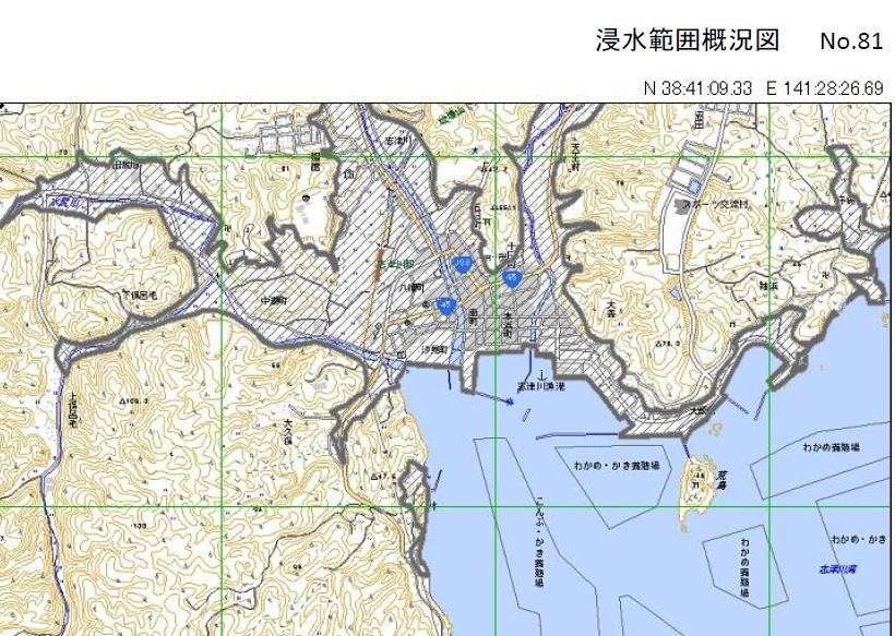
7 Tsunami Inundation Maps Inundation Areas by Photo Interpretation Correction Parameters for Horizontal Control Points Horizontal Vertical 7


 Mobile Mapping System (MMS)")
8 Recovery Planning Map 1:2,500 base map in support of reconstruction planning Equipment or Technical Methods Used by NGIA for Disaster Management Detection and analysis of ground surface movement with GNSS control point network and In SAR analysis Fault Modeling and Observation of Post Seismic Slow Slip Triangulation Survey and Leveling survey Aerial Survey (Aerial Photographs, Ortho Images and Photo Interpretation) Airborne Laser (DEM and 3D Maps) Mobile Mapping System (MMS) Thematic Mapping.. 8


9 Factors Contributing to Effective Disaster Preparedness by NGIA Archive Data (Aerial Photos, Base Maps and Thematic Maps ) Web Site Preparation of Data Distribution Routes to Government Organizations Disaster Drills for cooperation with government organizations Users of NGIA s Data and Services Central Government Offices - Prime Minister s Office - Ministry of Land, Infrastructure, Transport and Tourism - Relevant Ministries and Agencies Local Governments affected by the disaster General Public and Mass Media Researchers 9
10 Users of NGIA s Data and Services Briefing Maps MLIT Sit. Cen. Liaison PM Office Sit. Cen. Printed Central Gov. Maps Ministries Agencies Liaison HDD Web People/Media GSI HQ. Printed Map Team Liaison Printed Maps Gov. L.O. GSI R.O. Local Maps Governments Printed Maps S.D.F. HDD Local Governments HDD Cooperation with Related Communities for Disaster Management Dispatch of Liaisons to Operational Offices and to the affected areas - GSI send staffs as liaisons to the relevant administrative organizations. They understood the needs of relevant administrative organizations and GSI played a major role in providing maps and geospatial information required by the disaster response. Geospatial Information Support Team in GSI - One stop center at GSI HQs in the disaster response - 1,537 requests (by 2012/3/31) at 3.11 Earthquake - Provision the geospatial information effectively and easily understood properly Cooperation with the aerial survey companies in the disaster response - Emergency Aerial Photography 10

 Data of Ground Surface Movement with GNSS Control Point Network Aerial Photos and Ortho Images Disaster Overview Maps Thematic")
11 Arrangement for Emergency Aerial Photography Kinds of Data/Services NGIAs Should Deliver to the Communities NGIA should deliver the data/services that enlighten policy makers and government officials on utilization of the geospatial information in disaster management. Such data/services should provide common tools for utilization of the geospatial information in disaster management. Base Maps (paper and degital) Data of Ground Surface Movement with GNSS Control Point Network Aerial Photos and Ortho Images Disaster Overview Maps Thematic Maps Correction Parameters for Triangulation Points Recovery Planning Maps etc. 11
12 Role of UN-GGIM-AP in Disaster Management Share the NGIA s Experiences of Disaster Management with the Asia- Pacific countries Share the Disaster Information of Maps and Photos etc. with the Asia- Pacific countries Consultant of Technology Transfer on Disaster Management NGIA should (and can) contribute more in the stage of rescue and recovery. GSI has many experiences and know-how, especially against earthquake, volcano eruption and flood. GSI can share these experiences, so we welcome you to contact to us. Contact information [Name] Shin-ichi SAKABE [Organization Name] Geospatial Information Authority of Japan (GSI), Ministry of Land, Infrastructure, Transport and Tourism (MLIT) [ address] intex@gsi.go.jp 12
Roles of NGII in successful disaster management
 The Second UN-GGIM-AP Plenary Meeting Roles of NGII in successful disaster management Republic of Korea Teheran Iran 28 October 2013 Sanghoon Lee, Ph.D. NGII Outline Type of Disasters Occur in Korea Practical
Disaster Management in Republic of Korea
 The Third UN-GGIM-AP Plenary Meeting Disaster Management in Republic of Korea ~Coordination among NGIA & Other Related Organizations and Recommendations~ Bali Indonesia 10 November 2014 Sanghoon Lee, Ph.D.
The Role of Geospatial Information in Disaster Risk Reduction
 3rd High Level Forum on UN Global Geospatial Information Management in Beijing, Session 3: Climate Change and Disaster Mitigation 23 October 2014 The Role of Geospatial Information in Disaster Risk Reduction
NSDI Policy Framework of Japan - Roles of the Private Sector in SDI -
 NSDI Policy Framework of Japan - Roles of the Private Sector in SDI - Hiroshi Murakami (GSI) Geospatial World Forum 2012 Amsterdam Background Survey Act (1949) mandates the (GSI) to develop and provide
Report of the Working Group 2 Data Sharing and Integration for Disaster Management *
 UNITED NATIONS E/CONF.104/6 ECONOMIC AND SOCIAL COUNCIL Twentieth United Nations Regional Cartographic Conference for Asia and the Pacific Jeju, 6-9 October 2015 Item 5 of the provisional agenda Report
Sentinel Asia Tsunami Working Group
 Sentinel Asia Tsunami Working Group Co-Chairman: Prof. Shunichi Koshimura Abdul Muhari, PhD 4 th Joint Project Team Meeting (JPTM 2017): Sentinel Asia STEP 3 Abdul MUHARI, PhD Ministry of Marine Affairs
Disaster Management in Mongolia
 The Third UN-GGIM-AP Plenary Meeting Disaster Management in Mongolia ~Coordination among NGIA & Other Related Organizations and Recommendations~ Bali Indonesia 10 November 2014 Khurelshagai Ayurzana, Director
NCC roles in successful disaster response I.R.IRAN
 The Second UN-GGIM-AP Plenary Meeting NCC roles in successful disaster response I.R.IRAN Teheran Iran 28-30 October 2013 Ali Javidaneh Technical Deputy of National Cartographic Center (NCC) Outline Types
Report of the Regional Committee of UN-GGIM for Asia and the Pacific (UN-GGIM-AP)
") Report of the Regional Committee of UN-GGIM for Asia and the Pacific (UN-GGIM-AP) At the Eighth Session of UN-GGIM UN Headquarters, New York, 1 3 August 2018 About UN-GGIM-AP One of the five regional committees
Report of the Regional Committee of UN-GGIM for Asia and the Pacific (UN-GGIM-AP) At the Eighth Session of UN-GGIM UN Headquarters, New York, 1 3 August 2018 About UN-GGIM-AP One of the five regional committees
UN GGIM and National SDI Strategy
 MSDI Open Forum on 26 th January 2016 Contributing to the successful delivery of MSDI UN GGIM and National SDI Strategy Hiroshi Murakami Deputy Administrator Geospatial Information Authority of Japan Geospatial
How did the Geospatial Information Authority of Japan Respond to the 2016 Kumamoto Earthquake? 11
 How did the Geospatial Information Authority of Japan Respond to the 2016 Kumamoto Earthquake? 11 How did the Geospatial Information Authority of Japan Respond to the 2016 Kumamoto Earthquake? A Case Story
The Third UN-GGIM-AP Plenary Meeting. Use of Geospatial Information in Disaster and Coordination among NDMA and Relevant Organizations/Stakeholders
 The Third UN-GGIM-AP Plenary Meeting Use of Geospatial Information in Disaster and Coordination among NDMA and Relevant Organizations/Stakeholders Bali Indonesia 10 November 2014 Bernardus Wisnu Widjaja
Seismic Activity and Crustal Deformation after the 2011 Off the Pacific Coast of Tohoku Earthquake
 J-RAPID Symposium March 6-7, 2013 Seismic Activity and Crustal Deformation after the 2011 Off the Pacific Coast of Tohoku Earthquake Y. Honkura Tokyo Institute of Technology Japan Science and Technology
KNOWLEDGE NOTE 5-1. Risk Assessment and Hazard Mapping. CLUSTER 5: Hazard and Risk Information and Decision Making. Public Disclosure Authorized
 Public Disclosure Authorized Public Disclosure Authorized Public Disclosure Authorized Public Disclosure Authorized KNOWLEDGE NOTE 5-1 CLUSTER 5: Hazard and Risk Information and Decision Making Risk Assessment
Geospatial Infrastructure that Helps Keep us Resilient to Natural Disasters - Japan s example
 Regional Workshop on Strengthening Multi-Hazard Early Warning System in Pacific Islands Countries Nuku alofa, Tonga 26-27 April 2018 Geospatial Infrastructure that Helps Keep us Resilient to Natural Disasters
GEO-VIII November Geohazard Supersites and Natural Laboratories Progress Report. Document 9
 GEO-VIII 16-17 November 2011 Geohazard Supersites and Natural Laboratories Progress Report Document 9 This document is submitted to GEO-VIII for information. Geohazard Supersites and Natural Laboratories
EXTRACTION OF FLOODED AREAS DUE THE 2015 KANTO-TOHOKU HEAVY RAINFALL IN JAPAN USING PALSAR-2 IMAGES
 EXTRACTION OF FLOODED AREAS DUE THE 2015 KANTO-TOHOKU HEAVY RAINFALL IN JAPAN USING PALSAR-2 IMAGES F. Yamazaki a, *, W. Liu a a Chiba University, Graduate School of Engineering, Chiba 263-8522, Japan
Background Document: Report of the Regional Committee of United Nations Global Geospatial Information Management for Asia and the Pacific
 Background Document: Report of the Regional Committee of United Nations Global Geospatial Information Management for Asia and the Pacific 1. Summary 1. This report highlights the activities carried out
Utilization and Provision of Geographical Name Information on the Basic Map of Japan*
 UNITED NATIONS WORKING PAPER GROUP OF EXPERTS NO. 1/9 ON GEOGRAPHICAL NAMES Twenty-eight session 28 April 2 May 2014 Item 9 of the Provisional Agenda Activities relating to the Working Group on Toponymic
Risk-based land use and spatial planning
 Risk-based land use and spatial planning Miho OHARA International Centre for Water Hazards and Risk Management (ICHARM) Public Works Research Institute PWRI), Japan Under the auspices of UNESCO Introduction
Strategic Framework on Geospatial Information and Services for Disasters Relevance for the Americas Region
 Strategic Framework on Geospatial Information and Services for Disasters Relevance for the Americas Region Seventh Session of the Committee of Experts on UN-GGIM Side Event --- UN Headquarters, New York
How did the Geospatial Information Authority of Japan. Respond to the 2016 Kumamoto Earthquake? -A Case Story- October 2017
 How did the Geospatial Information Authority of Japan Respond to the 2016 Kumamoto Earthquake? -A Case Story- October 2017 Geospatial Information Authority of Japan Contents Introduction 1 Role of Geospatial
Global Map: A Tool for Disaster Mitigation for the Asia and Pacific Region
 Global Map: A Tool for Disaster Mitigation for the Asia and Pacific Region D. R. Fraser Taylor Chair, International Steering Committee for Global Mapping (ISCGM) fraser_taylor@carleton.ca www. 18 th United
Progress Report. Flood Hazard Mapping in Thailand
 Progress Report Flood Hazard Mapping in Thailand Prepared By: Mr. PAITOON NAKTAE Chief of Safety Standard sub-beuro Disaster Prevention beuro Department of Disaster Prevention and Mitigation THAILAND E-mail:
ÖBB Natural Hazard Management
 ÖBB Natural Hazard Management Management of Weather Events in the Austrian Federal Railways MOWE-IT, Brussels 17 th of September 2013 DI Günther Kundela Integrated Track Management Integration Technic
Geospatial Information Management in the Americas: Lessons for the Post-2015 development agenda
 Geospatial Information Management in the Americas: Lessons for the Post-2015 development agenda Rolando Ocampo President, UN-GGIM: Americas October 2014 The integration of statistical and geographical
Status and Challenges on Geo-DRM Information Systems in Tonga
 Name: Mafua- i-vai utukakau Maka Status and Challenges on Geo-DRM Information Systems in Tonga 1 Roles and Relationships Land and Geographic Information Systems (LGIS) Unit: Establish updated high-resolution
Norwegian spatial data infrastructure supporting disaster risk management Norwegian Mapping Authority
 Norwegian spatial data infrastructure supporting disaster risk management Norwegian Mapping Authority Arvid Lillethun, Norwegian Mapping Authority Land and Poverty 2018 Conference, World Bank 19.-23. March
State of Israel Ministry of Housing and Construction Survey of Israel. The Hydrological project case
 State of Israel Ministry of Housing and Construction Survey of Israel The Hydrological project case Survey of Israel Content Introduction To the Survey of Israel The operation assumptions The main responsibilities
SEISMIC RISK ASSESSMENT IN ARMENIA
 SEISMIC RISK ASSESSMENT IN ARMENIA Hovhannes Khangeldyan Head of National Crisis Management Center Rescue Service Ministry of Emergency Situations of the Republic of Armenia Tokyo, 2016 ARMENIA: GEOGRAPHICAL
GIS present situation in Japan
 GIS present situation in Japan September 26, 2006 INTERPREVENT 2006 in Niigata University Geographic Information Analysis Research Div. Geography and Crustal Dynamics Research Senter Geographical Survey
SDI DEVELOPMENT UPDATES OF INDONESIA
 SDI DEVELOPMENT UPDATES OF INDONESIA DR. ANTONIUS B. WIJANARTO Center For Management And Dissemination Of Geospatial Information GEOSPATIAL INFORMATION AUTHORITY GOVERNMENT OF THE REPUBLIC OF INDONESIA
Copernicus Overview and Emergency Management Service
 Copernicus Overview and Emergency Management Service Frédéric BASTIDE European Commission Open informal session of the United Nations Inter-Agency Meeting on Outer Space Activities 12 March 2013, Geneva
AND THE COOPERATION WITH SENTINEL ASIA FOR DISASTER MANAGEMENT
 Ministry of Natural resources and Environment National Remote Sensing DEpartment NATIONAL REMOTE SENSING DEPARTMENT (NRSD) AND THE COOPERATION WITH SENTINEL ASIA FOR DISASTER MANAGEMENT By: Dr. Chu Hai
Final Presentation on Disaster Risk Management in Japan. Through ADRC V. R Programme. Main Findings and Action Plan:
 Final Presentation on Disaster Risk Management in Japan Through ADRC V. R Programme Main Findings and Action Plan: Problem/Hazard and Disaster in Japan Good Practiced on Disaster Risk Management in Japan
Development of the Kingdom of Tonga Cyclone Emergency Recovery and Management System using Geospatial Tools
 Development of the Kingdom of Tonga Cyclone Emergency Recovery and Management System using Geospatial Tools Case Studies from Small Island States FIG Commissions 3, 7 and 8 Malcolm Archbold General Manager
"The Natural Disasters, like The Sumatra Tsunami had taught us before -BUT" U Than Myint President Myanmar Engineering Society
 "The Natural Disasters, like The Sumatra Tsunami had taught us before -BUT" U Than Myint President Myanmar Engineering Society Present Day Regional Tectonic Setting of South East Asia Tsunami-generated
JICA s Experiences of Connecting Japanese Science & Technologies for Disaster Risk Reduction in Developing Countries
 JICA s Experiences of Connecting Japanese Science & Technologies for Disaster Risk Reduction in Developing Countries Junji WAKUI Deputy Director General, Group Leader Disaster Risk Reduction Group Global
Concept Formulation of Geospatial Infrastructure. Hidenori FUJIMURA*
 Concept Formulation of Geospatial Infrastructure 1 Concept Formulation of Geospatial Infrastructure Hidenori FUJIMURA* (Published online: 28 December 2016) Abstract Technical trends in the field of surveying
The Efforts of Building GIS Infrastructure in a Newly Independent State: The case of Timor Leste *
 UNITED NATIONS E/CONF.100/IP.12 ECONOMIC AND SOCIAL COUNCIL Eighteenth United Nations Regional Cartographic Conference for Asia and the Pacific Bangkok, 26-29 October 2009 Item 7(b) of the provisional
4-3-1 Earthquake and Tsunami Countermeasures of Tokyo s
 4-3-1 Earthquake and Tsunami Countermeasures of Tokyo s Sewerage Masahiro Hikino* and Gaku Sato** *Planning Section, Planning and Coordinating Division, Bureau of Sewerage, Tokyo Metropolitan Government
Georeferencing and Satellite Image Support: Lessons learned, Challenges and Opportunities
 Georeferencing and Satellite Image Support: Lessons learned, Challenges and Opportunities Shirish Ravan shirish.ravan@unoosa.org UN-SPIDER United Nations Office for Outer Space Affairs (UNOOSA) UN-SPIDER
Report of PCGIAP to the 18 th United Nations Regional Cartographic Conference for Asia and the Pacific (UNRCC-AP) for the period
 for the period") Permanent Committee on GIS Infrastructure for Asia and the Pacific (PCGIAP) Established in 1995 by a United Nations Resolution Report of PCGIAP to the 18 th United Nations Regional Cartographic Conference
Permanent Committee on GIS Infrastructure for Asia and the Pacific (PCGIAP) Established in 1995 by a United Nations Resolution Report of PCGIAP to the 18 th United Nations Regional Cartographic Conference
Proposing Effective Method to Develop Common Operational Picture in Disaster Response Utilizing Cloud-based Geospatial Infrastructure
 Proposing Effective Method to Develop Common Operational Picture in Disaster Response Utilizing Cloud-based Geospatial Infrastructure Munenari Inoguchi Research Institute for Natural Hazard & Disaster
Challenges and Issues for Regional Geoportal on Disaster Data Sharing - from Perspective of China
 The 3 rd UN-GGIM-AP Plenary Meeting Challenges and Issues for Regional Geoportal on Disaster Data Sharing - from Perspective of China ZHOU Xu, Vice Chair of WG2 National Geomatics Center of China Outline
Outline of Guideline for Development and Utilization of Tsunami Disaster Management Map
 Outline of Guideline for Development and Utilization of Tsunami Disaster Management Map Port and Airport Research Institute, Japan The Overseas Coastal Area Development Institute of Japan Ports and Harbours
Prevention Tsunami wall 10m high (breached by the tsunami due to land level falling by 3m)
") Plate margin Plates Causes Sendai, Japan Convergent plate margin Pacific and Eurasian Plates Convergent plate margin Sima (Pacific plate) moves towards the sial (Eurasian plate) Sima (Pacific plate) is
Plate margin Plates Causes Sendai, Japan Convergent plate margin Pacific and Eurasian Plates Convergent plate margin Sima (Pacific plate) moves towards the sial (Eurasian plate) Sima (Pacific plate) is
The Impact of the 2010 Darfield (Canterbury) Earthquake on the Geodetic Infrastructure in New Zealand 1
 Earthquake on the Geodetic Infrastructure in New Zealand 1") The Impact of the 2010 Darfield (Canterbury) Earthquake on the Geodetic Infrastructure in New Zealand 1 Graeme BLICK, John BEAVAN, Chris CROOK, Nic DONNELLY Keywords: Darfield Earthquake, control, survey,
The Impact of the 2010 Darfield (Canterbury) Earthquake on the Geodetic Infrastructure in New Zealand 1 Graeme BLICK, John BEAVAN, Chris CROOK, Nic DONNELLY Keywords: Darfield Earthquake, control, survey,
Guidelines for Site-Specific Seismic Hazard Reports for Essential and Hazardous Facilities and Major and Special-Occupancy Structures in Oregon
 Guidelines for Site-Specific Seismic Hazard Reports for Essential and Hazardous Facilities and Major and Special-Occupancy Structures in Oregon By the Oregon Board of Geologist Examiners and the Oregon
Copernicus Overview. Major Emergency Management Conference Athlone 2017
 Copernicus Overview Major Emergency Management Conference Athlone 2017 Copernicus is a European programme implemented by the European Commission. The services address six thematic areas: land, marine,
How GNSS CORS in Japan works for geodetic control and disaster mitigations
 ICG Working Group D Reference Frames, Timing and Applications How GNSS CORS in Japan works for geodetic control and disaster mitigations ICG11, Nov. 7-11, 2016, Sochi, Russia Hiromichi TSUJI Geodetic Observation
History of International Training in Seismology and Earthquake Engineering at IISEE
 History of International Training in Seismology and Earthquake Engineering at IISEE Activities of International Institute of Seismology and Earthquake Engineering (IISEE), BRI - Training for young researchers/engineers
National Public Weather and Warning Services in the Swaziland Meteorological Service Dennis S.Mkhonta /
 National Public Weather and Warning Services in the Swaziland Meteorological Service Dennis S.Mkhonta dennis.mkhonta@gmail.com / dennis@swazimet.gov.sz Introduction Swaziland s geographical position exposes
Qatar s Nation-Wide GIS Cooperation on Local and Regional Levels
 Qatar s Nation-Wide GIS Cooperation on Local and Regional Levels Dr. Mohammad Abd El-Wahab Hamouda GIS Consultant & Chairman of GIS Coordinators Group The Center for GIS State of Qatar Second High Level
KARI Activation for the International Disasters
 KARI Activation for the International Disasters 5 th Joint Project Team Meeting for Sentinel Asia STEP2 (JPTM2012) 14 th Nov 2012 Boyeol Yoon Senior Researcher, Satellite Information Research Center (SIRC)
The World Bank Ecuador Risk Mitigation and Emergency Recovery Project (P157324)
") Public Disclosure Authorized LATIN AMERICA AND CARIBBEAN Ecuador Social, Urban, Rural and Resilience Global Practice Global Practice IBRD/IDA Investment Project Financing FY 2016 Seq No: 2 ARCHIVED on
Public Disclosure Authorized LATIN AMERICA AND CARIBBEAN Ecuador Social, Urban, Rural and Resilience Global Practice Global Practice IBRD/IDA Investment Project Financing FY 2016 Seq No: 2 ARCHIVED on
Application of a GIS for Earthquake Hazard Assessment and Risk Mitigation in Vietnam
 Application of a GIS for Earthquake Hazard Assessment and Risk Mitigation in Vietnam Nguyen Hong Phuong Earthquake Information and Tsunami Warning Centre, VAST OUTLINE Introduction Fault Source Model and
Applied Geoscience and Technology Division SOPAC. Joy Papao, Risk Information Systems Officer
 Joy Papao, Risk Information Systems Officer Secretariat of the Pacific Community SPC 22 Pacific Island States Head office in Noumea, New Caledonia 2 Regional offices (Pohnpei and Honiara) 600 staff 9 Technical
Australia Government Geospatial Capacity Building Efforts in Asia and the Pacific. Dr John Dawson
 Australia Government Geospatial Capacity Building Efforts in Asia and the Pacific Dr John Dawson Presentation Overview About Geoscience Australia Examples of Geospatial Capacity Building Activity Geodesy
Hurricane Preparation and Recovery. October 11, 2011 Jon Nance, Chief Engineer, NCDOT
 Hurricane Preparation and Recovery October 11, 2011 Jon Nance, Chief Engineer, NCDOT North Carolina & Severe Weather Our state often bears the brunt of storms, which include: Ice storms Snow storms Heavy
Hazardous Weather and Flooding Preparedness. Hazardous Weather and Flooding Preparedness
 Hazardous Weather and Flooding Preparedness 1 A Cooperative Effort 2 Administrative Information Emergency exits and procedures Location of restrooms Mobile devices Procedure for questions Course materials
Status & Challengers of Cook Islands GEO DRM. Cook Islands GEO S/GIS History
 Status & Challengers of Cook Islands GEO DRM By Patrick A. ARIOKA Planning & Advisory Officer EMERGENCY MANAGEMENT COOK ISLANDS Cook Islands GEO S/GIS History 1990 NZODA/MFAT trained by Landcare Research
Training System and Information Network for Earthquake Disaster Mitigation. Taiki SAITO. Building Research Institute (BRI)
") 1 Training System and Information Network for Earthquake Disaster Mitigation Taiki SAITO Chief Research Engineer, International Institute of Seismology and Earthquake Engineering (IISEE), Building Research
1 Training System and Information Network for Earthquake Disaster Mitigation Taiki SAITO Chief Research Engineer, International Institute of Seismology and Earthquake Engineering (IISEE), Building Research
GEOMATICS. Shaping our world. A company of
 GEOMATICS Shaping our world A company of OUR EXPERTISE Geomatics Geomatics plays a mayor role in hydropower, land and water resources, urban development, transport & mobility, renewable energy, and infrastructure
Positioning the Pacific: NOAA s Geospatial Activities. Juliana Blackwell, Director NOAA s National Geodetic Survey March 6, 2012
 Positioning the Pacific: NOAA s Geospatial Activities Juliana Blackwell, Director NOAA s National Geodetic Survey March 6, 2012 A Common Problem of the Early 19 th Century 1807 President Thomas Jefferson
Case study of Japan: Reference Frames in Practice
 Case study of Japan: Reference Frames in Practice Basara Miyahara and Koji Matsuo Sponsors: 1 Outline Introduction - Geodetic reference frame of Japan - GEONET : continuous GNSS observation system Geometric
F I G PA RT LX capacity in natural disaster area and disaster survey case in Jeju area
 F I G PA RT 7 2017. 12. 6. LX capacity in natural disaster area and disaster survey case in Jeju area Reporting order 1 2 3 General Information of LX Competence of LX on Natural disaster area Examples
Report for 15th PCGIAP Meeting at 18th UNRCC-AP Working Group 1 Regional Geodesy
 Report for 15th PCGIAP Meeting at 18th UNRCC-AP Working Group 1 Regional Geodesy Chairman Shigeru Matsuzaka, Japan - shigeru@gsi.go.jp Vice Chairman Prof. Pengfei Cheng, China - chengpf@casm.ac.cn John
Case Studies on Mega Cities
 Case Studies on Mega Cities Paul Kelly Director, Spatial Strategies Pty Ltd Vice Chair FIG Commission 3 The Case Study Cities Hong Kong SAR, China (Q) Tokyo, Japan (Q) Seoul, Korea (Q) Istanbul, Turkey
Interpretive Map Series 24
 Oregon Department of Geology and Mineral Industries Interpretive Map Series 24 Geologic Hazards, and Hazard Maps, and Future Damage Estimates for Six Counties in the Mid/Southern Willamette Valley Including
GENERAL. CHAPTER 1 BACKGROUND AND PURPOSE OF THE GUIDELINES Background of the Guidelines Purpose of the Guidelines...
 GENERAL CHAPTER 1 BACKGROUND AND PURPOSE OF THE GUIDELINES... 1 1.1 Background of the Guidelines... 1 1.2 Purpose of the Guidelines... 3 CHAPTER 2 APPLICATION OF THE GUIDELINES... 3 2.1 Potential Users
Geospatial application in Kiribati
 Geospatial application in Kiribati ICC-21 ST RESAP (9 TH TO 13 TH OCTOBER, 2017) BANGKOK, THAILAND Outline Kiribati Profile Natural disasters in Kiribati Achievements Challenges/Issues Ways forward 1 Kiribati
Progress on the Development of the Strategic Framework on Geospatial Information and Services for Disasters
 Progress on the Development of the Strategic Framework on Geospatial Information and Services for Disasters Dr. Peter N. Tiangco Administrator, NAMRIA, Philippines Co-chair, Working Group on Geospatial
Global Monitoring for Environment and Security (GMES)
") Global Monitoring for Environment and Security (GMES) Satellite Earth Observation for the Emergency Services Dr Nick Veck Presentation to the G-STEP Launch Univ. of Leicester 19 th June 2009 Contents of
Global Monitoring for Environment and Security (GMES) Satellite Earth Observation for the Emergency Services Dr Nick Veck Presentation to the G-STEP Launch Univ. of Leicester 19 th June 2009 Contents of
Economic and Social Council
 United Nations Economic and Social Council Distr.: General 18 July 2016 Original: English Committee of Experts on Global Geospatial Information Management Sixth session New York, 3-5 August 2016 Item 2
Basic Act on the Advancement of Utilizing Geospatial Information
 Basic Act on the Advancement of Utilizing Geospatial Information (Act No. 63 of May 30, 2007) Table of Contents Chapter I General Provisions (Articles 1 to 8) Chapter II Basic Plan for the Advancement
Introduction of PASCO Corporation
 Technical Seminar Reference Frame in Practice, Introduction of PASCO Corporation MASAKI MIYASAKA Sponsors: Page 1 Company Profile Establishment: October 27, 1953 Head office: Meguro-ku, Tokyo (57 offices
Word Cards. 2 map. 1 geographic representation. a description or portrayal of the Earth or parts of the Earth. a visual representation of an area
 Name: Date: Hour: Word Cards 1 geographic representation a description or portrayal of the Earth or parts of the Earth Example: A map is a representation of an actual location or place. 2 map a visual
Manitoba s Elevation (LiDAR) & Imagery Datasets. Acquisition Plans & Opportunities for Collaboration
 & Imagery Datasets. Acquisition Plans & Opportunities for Collaboration") Manitoba s Elevation (LiDAR) & Imagery Datasets Acquisition Plans & Opportunities for Collaboration Manitoba Planning Conference May 2017 Presentation Outline Manitoba s Elevation (LiDAR) and Imagery Datasets
Manitoba s Elevation (LiDAR) & Imagery Datasets Acquisition Plans & Opportunities for Collaboration Manitoba Planning Conference May 2017 Presentation Outline Manitoba s Elevation (LiDAR) and Imagery Datasets
Establishment of WINDS Ground Station in Sri Lanka. By G.K.D. Amarawardena Additional Secretary Ministry of Disaster Management Sri Lanka
 Establishment of WINDS Ground Station in Sri Lanka By G.K.D. Amarawardena Additional Secretary Ministry of Disaster Management Sri Lanka Contents Background SAS Implementation Progress of WINDS establishment
Emergency Management Service (EMS) mapping
 mapping") GMES Emergency Management Service (EMS) mapping Frédéric BASTIDE GMES unit, European Commission UN-SPIDER Expert Meeting: "Crowdsource Mapping for Disaster Risk Management and Emergency Response" 3-5 December,
GMES Emergency Management Service (EMS) mapping Frédéric BASTIDE GMES unit, European Commission UN-SPIDER Expert Meeting: "Crowdsource Mapping for Disaster Risk Management and Emergency Response" 3-5 December,
Economic and Social Council
 United Nation E/C.20/2012/4/Add.1 Economic and Social Council Distr.: General 2 July 2012 Original: English Committee of Experts on Global Geospatial Information Management Second session New York, 13-15
The Use of Geographic Information Systems (GIS) by Local Governments. Giving municipal decision-makers the power to make better decisions
 by Local Governments. Giving municipal decision-makers the power to make better decisions") The Use of Geographic Information Systems (GIS) by Local Governments Giving municipal decision-makers the power to make better decisions Case Study: Examples of GIS Usage by Local Governments in North
The Use of Geographic Information Systems (GIS) by Local Governments Giving municipal decision-makers the power to make better decisions Case Study: Examples of GIS Usage by Local Governments in North
3D Seismic Hazard and Risk Maps for Earthquake Awareness of Citizens with Aids of GIS and Remote Sensing Technologies
 3D Seismic Hazard and Risk Maps for Earthquake Awareness of Citizens with Aids of GIS and Remote Sensing Technologies Saburoh Midorikawa Tokyo Institute of Technology In Japan, seismic hazard and risk
Risk Management Strategy
 Risk Management Strategy 1 Purpose To protect the component parts of the World Heritage property as well as the lives and the property of visitors and residents from disasters such as volcanic eruptions,
GUIDELINES FOR CONSTRUCTION TECHNOLOGY TRANSFER DEVELOPMENT OF WARNING AND EVACUATION SYSTEM AGAINST SEDIMENT DISASTERS IN DEVELOPING COUNTRIES
 GUIDELINES FOR CONSTRUCTION TECHNOLOGY TRANSFER DEVELOPMENT OF WARNING AND EVACUATION SYSTEM AGAINST SEDIMENT DISASTERS IN DEVELOPING COUNTRIES MARCH 2004 Ministry of Land, Infrastructure and Transport
Overview of Technical Advisory Missions
 Expert Group Meeting (EGM) on Georeferenced Information Systems for Disaster Risk Management (Geo-DRM) and sustaining the Community of Practice (COP) 23-25 April 2014 Bangkok Overview of Technical Advisory
GEOLOGICAL HAZARD MITIGATION STRATEGY IN INDONESIA
 GEOLOGICAL HAZARD MITIGATION STRATEGY IN INDONESIA Surono Head of Geological Agency presented in: The 2nd Global Summit of Research Institutes for Disaster Risk Reduction Kihada Hall, Uji Campus, Kyoto
Topographic Strategy National Topographic Office March 2015
 www.linz.govt.nz Topographic Strategy National Topographic Office March 2015 >> Foreword Topographic information is vital to understanding our country and its assets, and for supporting economic development.
Country Report on SDI Activities in Singapore *
 UNITED NATIONS E/CONF.100/CRP.9 ECONOMIC AND SOCIAL COUNCIL Eighteenth United Nations Regional Cartographic Conference for Asia and the Pacific Bangkok, 26-29 October 2009 Item 7(a) of the provisional
LAND USE PLANNING AND RISK: LESSONS FROM THREE AUSTRALIAN PORT CITIES
 LAND USE PLANNING AND RISK: LESSONS FROM THREE AUSTRALIAN PORT CITIES Ken Granger Disaster Risk Scientist Slide No. 1 Land use planning is the single most important mitigation measure for limiting future
Progress Report: Sentinel Asia Success Story in the Philippines
 Progress Report: Sentinel Asia Success Story in the Philippines 3 rd Joint Project Team Meeting on the Sentinel Asia STEP-2 July 6-8, 2010 Hyatt Hotel, Manila, Philippines Renato U. Solidum Jr. Director
STUDY ON URGENT ESTABLISHMENT OF TOPOGRAPHIC MAPPING IN EAST TIMOR CREATION OF TOPOGRAPHIC INFORMATION FOR ESTABLISHMENT OF CADASTRE IN EAST TIMOR
 STUDY ON URGENT ESTABLISHMENT OF TOPOGRAPHIC MAPPING IN EAST TIMOR CREATION OF TOPOGRAPHIC INFORMATION FOR ESTABLISHMENT OF CADASTRE IN EAST TIMOR Toru WATANABE, Japan The first digital topographic mapping
Training System and Information Network for Earthquake Disaster Mitigation. Taiki SAITO. Building Research Institute (BRI)
") Asian Science and Technology Forum Tsukuba Seminar, 2007.10.03, Tsukuba Training System and Information Network for Earthquake Disaster Mitigation Taiki SAITO Chief Research Engineer, International Institute
Asian Science and Technology Forum Tsukuba Seminar, 2007.10.03, Tsukuba Training System and Information Network for Earthquake Disaster Mitigation Taiki SAITO Chief Research Engineer, International Institute
NOAA S2S Planning. Dave DeWitt Fred Toepfer
 NOAA S2S Planning Dave DeWitt Fred Toepfer 1 Agenda 1. Brief synopsis of The Weather Research and Forecasting Act of 2017 2. Report to Congress a. Timeline b. Process c. Document Outline 3. Some Preliminary
Application of high-resolution (10 m) DEM on Flood Disaster in 3D-GIS
 DEM on Flood Disaster in 3D-GIS") Risk Analysis V: Simulation and Hazard Mitigation 263 Application of high-resolution (10 m) DEM on Flood Disaster in 3D-GIS M. Mori Department of Information and Computer Science, Kinki University, Japan
Risk Analysis V: Simulation and Hazard Mitigation 263 Application of high-resolution (10 m) DEM on Flood Disaster in 3D-GIS M. Mori Department of Information and Computer Science, Kinki University, Japan
KNOWLEDGE NOTE 5-2. Risk and Damage Information Management. CLUSTER 5: Hazard and Risk Information and Decision Making
 KNOWLEDGE NOTE 5-2 CLUSTER 5: Hazard and Risk Information and Decision Making Risk and Damage Information Management 1 Prepared by Keiko Saito, World Bank. Special thanks to the Earthquake Engineering
Case Study of Japan: Crustal deformation monitoring with GNSS and InSAR
 Technical Seminar Reference Frame in Practice, Case Study of Japan: Crustal deformation monitoring with GNSS and InSAR Basara Miyahara miyahara-b96ip@milt.go.jp Geospatial Information Authority of Japan
County Report on the status of Geospatial Information activity of Japan *
 UNITED NATIONS E/CONF.102/CRP.1 ECONOMIC AND SOCIAL COUNCIL Nineteenth United Nations Regional Cartographic Conference for Asia and the Pacific Bangkok, 29 October 1 November 2012 Item 6(a) of the provisional
International Cooperation on Earthquake Disaster Management to Protect Lives
 Pontificia Universidad Católica de Chile Chile, un país s con múltiples m amenazas International Cooperation on Earthquake Disaster Management to Protect Lives Raúl Alvarez Medel, Pontificia Universidad