GEOLOGICAL HAZARD MITIGATION STRATEGY IN INDONESIA
|
|
|
- Nathaniel Richardson
- 6 years ago
- Views:
Transcription
1 GEOLOGICAL HAZARD MITIGATION STRATEGY IN INDONESIA Surono Head of Geological Agency presented in: The 2nd Global Summit of Research Institutes for Disaster Risk Reduction Kihada Hall, Uji Campus, Kyoto University Kyoto, Japan, March 19-20, 2015 Ministry of Energy and Mineral Resources Geological Agency Jln. Diponegoro no. 57 Bandung 40122, Jawa Barat, Republic of Indonesia Phone: , Fax: , Website : geologi@bgl.esdm.go.id

2 Indonesian children s painting

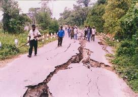
3 Background Indonesia is located between the collision of 3 major tectonic plates including Eurasia, Indo-Australia and Pacific plates. EURASIAN PLATE INDO-AUSTRALIA PLATE PASICIC PLATE Indonesia s tectonic settings resulted in abundant natural resources including geological hazard, such as: 1. Earthquakes & tsunamis 2. Landslides 3. Volcanic eruptions 4. etc 127 volcanoes (13 % of the World s volcanoes) 67 volcanoes have erupted at least once since 1600 (Type- A) and are continuously monitored by 74 volcano observatories


4 Earthquake Volcano Eruption Landslide Tsunami Major Geological Hazard in Indonesia
, Indonesia 9.")
5 Statistics of geological disasters victims in Indonesia Date Location M Victims 2011/3/11 Tohoku, Japan 9.0 >20, /1/12 Haiti , /9/30 Padang, Indonesia 7.5 1, /5/12 Sichuan, China , /5/26 Yogjakarta, Indonesia 6.3 5, /10/8 Kashmir, Pakistan , /3/28 Nias, Indonesia 8.6 1, /12/26 Sumatra (Aceh), Indonesia , /12/26 Bam, Iran , /5/21 Algeria 6.8 2, /3/25 Afghanistan 6.1 1, /1/26 Bhuj, India ,023 List of earthquakes that have caused more than 1000 victims since year 2000 Year Location Victims Sunda Strait (following Krakatau eruption) 36,000 West Sumatera, Bengkulu, Lampung Unknown 1938 Kai Island Banda Unknown 1967 Tinambung Tambu, Southeast of Sulawesi Sumbawa Flores 2, Banyuwangi Toli-toli Biak Banggai Nanggroe Aceh Darussalam South of Java 265, List of tsunami occurrence and victims in Indonesian history. Mortality caused by volcanic eruptions in Indonesia. Mortality caused by volcanic eruptions in world. Indonesia has been recognized as the world s most victims caused by volcanic eruptions. Distribution of victims caused by natural hazards. Landslide manifests the third deadliest natural hazard in Indonesia (after flood and tornado).


6 Challenges : Geological hazard areas are becoming more populated Hazardous areas in Indonesia are typically fertile land, have an abundant amount of water, and beautiful scenery. Consequently, people are attracted to live and conduct activities in hazardous areas.


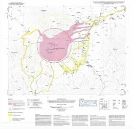
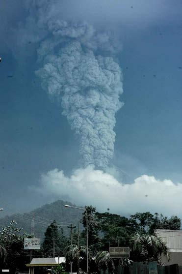
7 The Geological Agency (since 1850) The Volcanological Survey was initiated in 1920 in response to the 1919 eruptions of Kelud volcano in East Java. Kelud Volcano 1919
8 Task and Function of the Geological Agency Legal Basis Indonesian Constitution Mandate of Laws: Geothermal, Oil and Gas, Mining, Mineral and Coal, Water Resources, Spatial Planning, Hazard Mitigation, Environmental Management Challenges and strategic issues (national and global) VISION Protection and welfare of the community Geological Resources Geological Hazard GEOSAINS Environment FUNCTION Research and services in geological areas Development Program in Geological Areas Development of energy resources Development of mineral resources Groundwater management Geological hazard mitigation Environmental management/spatial planning Data management and geological information
9 Regulations Concerning Geological Hazard Mitigation in Indonesia UU RI n. 24 Year 2007 : Disaster Management UU RI n. 26 Year 2007 : Spatial Planning PP n. 21 Year 2008 : Implementation of Disaster Management PERMEN ESDM n. 18 Year 2010 : Organization and Administration of the Ministry of Energy and Mineral Resources PERMEN ESDM n. 15 Year 2011 : Guidelines for Geological Hazard Mitigation including Volcanic Eruptions, Landslides, Earthquakes and Tsunamis
10 Regulations Concerning Geological Hazard Mitigation in Indonesia UU RI (law of the Republic of Indonesia) no. 24 Year 2007 concerning Disaster management UU RI (law of the Republic of Indonesia) no. 26 Year 2007 concerning Spatial Planning The existence of these two laws have changed the paradigm of disaster management which is more focused on pre-disaster efforts.


11 Task and Function of Geological Agency concerning Hazard Mitigation based on the Regulation of the Minister of Energy and Mineral Resources N o 18/2010 Task Responsible for conducting research, investigation, engineering and services in the field of volcanology and geological hazard mitigation. Function - Conduct monitoring, research, thematic mapping, geological disaster risk analysis - Early warning of volcanic activities, landslide potential and technical recommendation in geological hazard mitigation.

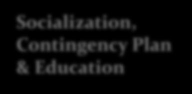

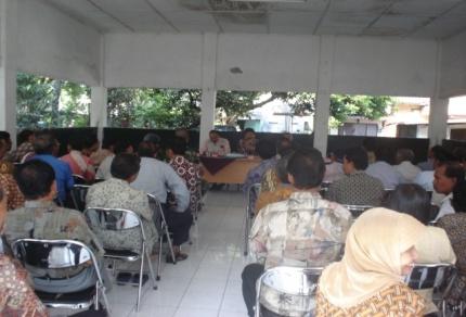
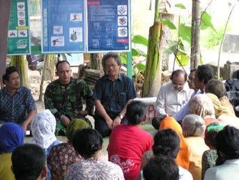

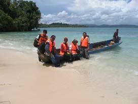
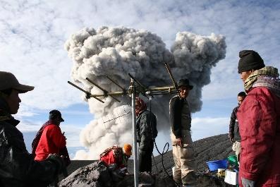
12 Strategy Of Geological Hazard Mitigation in Indonesia Research & Monitoring Hazard Mapping Socialization, Contingency Plan & Education Quick Response


13 International and National Cooperation (past 10 years) etc

14
15 CHALLENGES Dense population and high rate of population growth, the risk due to geological hazard in Indonesia is very high. Our main challenges are : Evaluate the effectiveness and develop the existing mitigation system. Increase the capacity of people living around the hazardous areas to create a resilience society to destructive geological hazard. Empower the participation of all elements of the society in disaster mitigation system.

16 Ministry of Energy and Mineral Resources Geological Agency Jln. Diponegoro no. 57 Bandung 40122, Jawa Barat, Republic of Indonesia Phone: , Fax: , Website : geologi@bgl.esdm.go.id
TSUNAMI AND EARTHQUAKE ACTIVITY IN INDONESIA *
 LOCAL TSUNAMI WARNING AND MITIGATION TSUNAMI AND EARTHQUAKE ACTIVITY IN INDONESIA * Nanang T. Puspito Department of Geophysics and Meteorology, Institute of Technology Bandung (ITB) Address: Jalan Ganeca
Earth Issue: November 2017
 Earth Issue: November 2017 Earthquake Risk In Indonesia Damage in Banda Aceh During 2004 tsunami Source: US Military The Indonesian archipelago is located at the boundary of three major tectonic plates,
STUDY ON TSUNAMIGENIC EARTHQUAKE CRITERIA FOR THE INDONESIAN TSUNAMI EARLY WARNING SYSTEM
 STUDY ON TSUNAMIGENIC EARTHQUAKE CRITERIA FOR THE INDONESIAN TSUNAMI EARLY WARNING SYSTEM Nanang T. Puspito 1 1 Geophysics Research Group, Faculty of Mining and Petroleum Engineering, Institute of Technology
The Challenge of Earthquake Disaster in Indonesia. Hery Harjono Indonesian Institute of Sciences
 The Challenge of Earthquake Disaster in Indonesia Hery Harjono Indonesian Institute of Sciences * Presented at the J-Rapid Symposium, Sendai, Japan, March 6-7, 2013 INTRODUCTION The 2004 Giant Sumatran-Andaman
What is a Tsunami? Tsu = harbor Nami = wave (Japanese terms)
") Tsunami Hazard What is a Tsunami? Tsu = harbor Nami = wave (Japanese terms) A tsunami is a series of travelling waves most commonly generated by vertical displacements of the sea floor associated with
Tsunami Hazard What is a Tsunami? Tsu = harbor Nami = wave (Japanese terms) A tsunami is a series of travelling waves most commonly generated by vertical displacements of the sea floor associated with
INTRODUCTION Full Name : Republic Indonesia Area : 1,904,000 sq Km Capital City : Jakarta
 INTRODUCTION Full Name : Republic Indonesia Area : 1,904,000 sq Km Capital City : Jakarta Papua Population : More than 210 Million People (2002) Season : Dry and Rainy Season Total Number Of Island : 17.583
Building Disaster Resilience Community in Asia: Indonesian perspective
 Workshop C of the 7th Science Council of Asia (SCA) Conference Construction of Secure and Safe Society against Global Changes of Natural Disasters Okinawa, June 14 th, 2007 Building Disaster Resilience
The Third UN-GGIM-AP Plenary Meeting. Use of Geospatial Information in Disaster and Coordination among NDMA and Relevant Organizations/Stakeholders
 The Third UN-GGIM-AP Plenary Meeting Use of Geospatial Information in Disaster and Coordination among NDMA and Relevant Organizations/Stakeholders Bali Indonesia 10 November 2014 Bernardus Wisnu Widjaja
Global Map: A Tool for Disaster Mitigation for the Asia and Pacific Region
 Global Map: A Tool for Disaster Mitigation for the Asia and Pacific Region D. R. Fraser Taylor Chair, International Steering Committee for Global Mapping (ISCGM) fraser_taylor@carleton.ca www. 18 th United
Word Cards. 2 map. 1 geographic representation. a description or portrayal of the Earth or parts of the Earth. a visual representation of an area
 Name: Date: Hour: Word Cards 1 geographic representation a description or portrayal of the Earth or parts of the Earth Example: A map is a representation of an actual location or place. 2 map a visual
2018 REVIEW OF DISASTER EVENTS
 2018 REVIEW OF DISASTER EVENTS Supplementary Information* BRUSSELS, 24 January, 2019 In 2018, there were 281 climate-related and geophysical events recorded in the EM-DAT (International Disaster Database)
Volcanic Disaster Mitigation for Living in Harmony with Active Volcanoes
 Volcanic Disaster Mitigation for Living in Harmony with Active Volcanoes SURONO Expert Staf of Ministry of Energy and Mineral Resources, Republic of Indonesia Presented on : The 9 th International Graduate
Predicting Tsunami Inundated Area and Evacuation Road Based On Local Condition Using GIS
 IOSR Journal of Environmental Science, Toxicology and Food Technology (IOSR-JESTFT) ISSN: 2319-2402, ISBN: 2319-2399. Volume 1, Issue 4 (Sep-Oct. 2012), PP 05-11 Predicting Tsunami Inundated Area and Evacuation
Weather Satellite Data Applications for Monitoring and Warning Hazard at BMKG
 The 5th Meeting of the Coordinating Group of the RA II WIGOS Satellite Project 21 October 2017, Vladivostok city, Russky Island, Russia Far Eastern Federal University Weather Satellite Data Applications
International Research Collaboration in Indonesia: LIPI as a special reference
 Workshop on Science & Technology Cooperation With Developing Countries on Global Issues. Tokyo, 8 October 2008 International Research Collaboration in Indonesia: LIPI as a special reference Hery Harjono
Socio-Eco-Engineering-based Approach on Integrated Sediment Management in Mt. Merapi Area, Indonesia
 Socio-Eco-Engineering-based Approach on Integrated Sediment Management in Mt. Merapi Area, Indonesia Legono DJOKO, 1,* Katsuhiko OTANI 2, and Suharyanto 3 1 Civil and Environmental Engineering Department,
NGIAs' roles in successful disaster response
 The Second UN-GGIM-AP Plenary Meeting NGIAs' roles in successful disaster response Japan Teheran Iran 28 October 2013 Shin-ichi SAKABE, Director of International Affairs Division Geospatial Information
ENHANCING COMMITMENTS TO DISASTER PREPAREDNESS AND RESILIENCE OF PEOPLE WITH DISABILITIES
 ENHANCING COMMITMENTS TO DISASTER PREPAREDNESS AND RESILIENCE OF PEOPLE WITH DISABILITIES Global Risk Forum GRF Davos www.grforum.org Global Risk Forum GRF Davos Disasters Conflicts Natural Hazards Anthropogenic
Cooperating Country Report of GERMANY
 CCOP-47AS/4.1-19 COORDINATING COMMITTEE FOR GEOSCIENCE PROGRAMMES IN EAST AND SOUTHEAST ASIA (CCOP) 47 th CCOP Annual Session 17-21 October 2010 Manado, Indonesia Cooperating Country Report of GERMANY
SPICE & Disaster Risk Managment
 SPICE & Disaster Risk Managment Linking Integrated Coastal Zone Management (ICZM) with Tsunami Disaster Risk Management: Some Experiences from Capacity Building Measures in Indonesia International Symposium
LEMBAGA PENERBANGAN DAN ANTARIKSA NASIONAL INDONESIAN NATIONAL INSTITUTE OF AERONAUTICS AND SPACE (LAPAN)
") LEMBAGA PENERBANGAN DAN ANTARIKSA NASIONAL INDONESIAN NATIONAL INSTITUTE OF AERONAUTICS AND SPACE (LAPAN) The Utilization of Remotely Sensed Data to Analyze The Estimated Volume of Pyroclastic Deposits
LEMBAGA PENERBANGAN DAN ANTARIKSA NASIONAL INDONESIAN NATIONAL INSTITUTE OF AERONAUTICS AND SPACE (LAPAN) The Utilization of Remotely Sensed Data to Analyze The Estimated Volume of Pyroclastic Deposits
5. Principles. 1. Malaysia is not free from. Kuala Teriang, Langkawi
 5. Principles 1. Malaysia is not free from seismic-induced geohazards. However, the degree and magnitude of the geohazards are relatively small or minor because Malaysia is located in a stable tectonic
LOCAL TSUNAMIS: CHALLENGES FOR PREPAREDNESS AND EARLY WARNING
 LOCAL TSUNAMIS: CHALLENGES FOR PREPAREDNESS AND EARLY WARNING HARALD SPAHN 1 1 German Technical Cooperation International Services, Jakarta, Indonesia ABSTRACT: Due to the threat of local tsunamis warning
Predicting of Tsunami Inundation Area based on Propagation and Runup Numerical Model in Pacitan City
 Predicting of Tsunami Inundation Area based on Propagation and Runup Numerical Model in Pacitan City 1 Agus Suharyanto, 1 Alwafi Pujiraharjo, 2 Adipandang Yudono, 3 Keisuke Murakami, and 3 Chikashi Deguchi
SEISMIC RISK ASSESSMENT IN ARMENIA
 SEISMIC RISK ASSESSMENT IN ARMENIA Hovhannes Khangeldyan Head of National Crisis Management Center Rescue Service Ministry of Emergency Situations of the Republic of Armenia Tokyo, 2016 ARMENIA: GEOGRAPHICAL
In Issue of International Sabo News Letter
 In Issue of International Sabo News Letter I had an opportunity to make a keynote speech on March 18 2003 at the session on Sedimentrelated Issues at the 3rd World Water Forum held in (Kyoto) Japan. Chairing
REGIONAL GROUND MOTION PREDICTION AND DATABASE
 REGIONAL GROUND MOTION PREDICTION AND DATABASE 1.1 Identification of Primary input parameters a. Magnitudes and intensities of historical Earthquake In this recent century, Indonesia has been impacted
MAP FOR COMMUNICATING NATURAL HAZARDS: AN EVALUATION OF INDONESIA PRE-DISASTER SPATIAL INFORMATION
 CO-147 MAP FOR COMMUNICATING NATURAL HAZARDS: AN EVALUATION OF INDONESIA PRE-DISASTER SPATIAL INFORMATION NARIESWARI L., MUNAJATI S.L., KRESNAWATI D.K., WINDIASTUTI R. BAKOSURTANAL (National Coordinating
Increasingly technological
 QU: How can tectonic events be managed? AIM: To explain the approaches to tectonic hazard prediction, monitoring and event modification. Hazard Modification, Mitigation and Adaption Modify the loss Modify
UNIVERSITY GADJAH MADA EUBIOS YOUTH LOOKING BEYOND DISASTER (LBD5) FORUM 4-8 SEPTEMBER, Hosted by: Universitas Gadjah Mada
 FORUM 4-8 SEPTEMBER, Hosted by: Universitas Gadjah Mada") UNIVERSITY GADJAH MADA EUBIOS YOUTH LOOKING BEYOND DISASTER (LBD5) FORUM 4-8 SEPTEMBER, 2014 Hosted by: Universitas Gadjah Mada Outline LBD program Brief Information of Universitas Gadjah Mada, Indonesia
UNIVERSITY GADJAH MADA EUBIOS YOUTH LOOKING BEYOND DISASTER (LBD5) FORUM 4-8 SEPTEMBER, 2014 Hosted by: Universitas Gadjah Mada Outline LBD program Brief Information of Universitas Gadjah Mada, Indonesia
GEO-VIII November Geohazard Supersites and Natural Laboratories Progress Report. Document 9
 GEO-VIII 16-17 November 2011 Geohazard Supersites and Natural Laboratories Progress Report Document 9 This document is submitted to GEO-VIII for information. Geohazard Supersites and Natural Laboratories
Report of the Working Group 2 Data Sharing and Integration for Disaster Management *
 UNITED NATIONS E/CONF.104/6 ECONOMIC AND SOCIAL COUNCIL Twentieth United Nations Regional Cartographic Conference for Asia and the Pacific Jeju, 6-9 October 2015 Item 5 of the provisional agenda Report
Tectonic Processes and Hazards Enquiry Question 1: Why are some locations more at risk from tectonic hazards?
 Tectonic Processes and Hazards Enquiry Question 1: Why are some locations more at risk from tectonic hazards? Key words Basalt Andesite Rhyolite Benioff Zone Subduction zone Crustal fracturing Definition
The Indian Ocean. Copyright 2010 LessonSnips
 The Indian Ocean One of the five major geographic divisions of the world s ocean, the Indian Ocean is located in the Eastern Hemisphere. The Indian Ocean is bounded by three continents: Africa to the west,
Earthquake Risk in Indonesia
 過去の火災事例 MM I TTSS UU I SSUU MMI I TTOO MMOO I NN SSUURR AA NN CC EE GG RR OOUUPP INTTEERRI I ISSK AASSI IAA PPTTEE LLTTD... Earthquake Risk in Indonesia October 2009 In Indonesia, the Sumatra Earthquake
Role of Science and Technology in Disaster Preparedness in Indonesia
 2014/SOM3/EPWG/SDMOF/014 Session 1 Role of Science and Technology in Disaster Preparedness in Indonesia Submitted by: Indonesia 8 th Senior Disaster Management Officials Forum Beijing, China 11-12 August
Ring of Fire: ICT for Disaster Mi4ga4on and Environment Protec4on. Hammam Riza Deputy Chairman Agency for the Assessment and Applica:on of Technology
 Ring of Fire: ICT for Disaster Mi4ga4on and Environment Protec4on Hammam Riza Deputy Chairman Agency for the Assessment and Applica:on of Technology INDONESIA - RING OF FIRE Most of the big ci:es in the
DATA BASE DEVELOPMENT OF ETA (ESTIMATED TIME OF ARRIVAL) FOR TSUNAMI DISASTER MITIGATION AT SOUTHWESTERN CITIES OF ACEH, INDONESIA
 FOR TSUNAMI DISASTER MITIGATION AT SOUTHWESTERN CITIES OF ACEH, INDONESIA") 6 th South China Sea Tsunami Workshop Nanyang Technology University, Singapore, 6-8 November 2013 DATA BASE DEVELOPMENT OF ETA (ESTIMATED TIME OF ARRIVAL) FOR TSUNAMI DISASTER MITIGATION AT SOUTHWESTERN
6 th South China Sea Tsunami Workshop Nanyang Technology University, Singapore, 6-8 November 2013 DATA BASE DEVELOPMENT OF ETA (ESTIMATED TIME OF ARRIVAL) FOR TSUNAMI DISASTER MITIGATION AT SOUTHWESTERN
Earthquake Hazards. Tsunami
 Earthquake Hazards Tsunami Measuring Earthquakes Two measurements that describe the power or strength of an earthquake are: Intensity a measure of the degree of earthquake shaking at a given locale based
Earthquake Hazards. Tsunami
 Earthquake Hazards Tsunami Review: What is an earthquake? Earthquake is the vibration (shaking) and/or displacement of the ground produced by the sudden release of energy. The point inside the Earth where
Prof. Isaac Kerlow. Principal Investigator Art+Media Group Leader
 Prof. Isaac Kerlow Principal Investigator Art+Media Group Leader The EOS/AXA Partnership The EOS/AXA Partnership 1. AXA Chair for Natural Hazards 2. Living with Disaster Mission of the Earth Observatory
Risk-based land use and spatial planning
 Risk-based land use and spatial planning Miho OHARA International Centre for Water Hazards and Risk Management (ICHARM) Public Works Research Institute PWRI), Japan Under the auspices of UNESCO Introduction
Center for Spatial Data Infrastructures and Land Administration Department of Geomatics, University of Melbourne. Content
 Heri SUTANTA, Abbas RAJABIFARD, Ian BISHOP Center for Spatial Data Infrastructures and Land Administration Department of Geomatics, University of Melbourne Content Introduction Coastal Urban Environment
Hazardous Weather and Flooding Preparedness. Hazardous Weather and Flooding Preparedness
 Hazardous Weather and Flooding Preparedness 1 A Cooperative Effort 2 Administrative Information Emergency exits and procedures Location of restrooms Mobile devices Procedure for questions Course materials
Disaster Risk Reduction in Survey for Seismic Protection of MES
 Survey for Seismic Protection Ministry of Emergency Situations of Republic of Armenia Disaster Risk Reduction in Survey for Seismic Protection of MES Syuzanna Kakoyan Leading specialist at the Department
One map policy (OMP) implementation strategy to accelerate mapping of regional spatial planing (RTRW) in Indonesia
 implementation strategy to accelerate mapping of regional spatial planing (RTRW) in Indonesia") IOP Conference Series: Earth and Environmental Science PAPER OPEN ACCESS One map policy (OMP) implementation strategy to accelerate mapping of regional spatial planing (RTRW) in Indonesia To cite this
IOP Conference Series: Earth and Environmental Science PAPER OPEN ACCESS One map policy (OMP) implementation strategy to accelerate mapping of regional spatial planing (RTRW) in Indonesia To cite this
DEBRIS FLOW DISASTER MITIGATION THROUGH COMMUNITY-BASED INTEGRATED SEDIMENT MANAGEMENT (BEST PRACTICE IN MT. MERAPI AREA, INDONESIA)
") Civil Engineering Forum Volume XXI/3 - September 2012 DEBRIS FLOW DISASTER MITIGATION THROUGH COMMUNITY-BASED INTEGRATED SEDIMENT MANAGEMENT (BEST PRACTICE IN MT. MERAPI AREA, INDONESIA) K. Otani Yachiyo
Civil Engineering Forum Volume XXI/3 - September 2012 DEBRIS FLOW DISASTER MITIGATION THROUGH COMMUNITY-BASED INTEGRATED SEDIMENT MANAGEMENT (BEST PRACTICE IN MT. MERAPI AREA, INDONESIA) K. Otani Yachiyo
GENERAL. CHAPTER 1 BACKGROUND AND PURPOSE OF THE GUIDELINES Background of the Guidelines Purpose of the Guidelines...
 GENERAL CHAPTER 1 BACKGROUND AND PURPOSE OF THE GUIDELINES... 1 1.1 Background of the Guidelines... 1 1.2 Purpose of the Guidelines... 3 CHAPTER 2 APPLICATION OF THE GUIDELINES... 3 2.1 Potential Users
Uses of The Climate and Climate-related Hazard Information in The Adaptation Strategies for Development and Spatial Planning Assessments
 Uses of The Climate and Climate-related Hazard Information in The Adaptation Strategies for Development and Spatial Planning Assessments Wilmar Salim, ST., M. Reg. Dev., Ph.D. Yogyakarta Monday, March
Indian Ocean Tsunami Warning System: Example from the 12 th September 2007 Tsunami
 Indian Ocean Tsunami Warning System: Example from the 12 th September 2007 Tsunami Charitha Pattiaratchi 1 Professor of Coastal Oceanography, The University of Western Australia Email: chari.pattiaratchi@uwa.edu.au
Australia Government Geospatial Capacity Building Efforts in Asia and the Pacific. Dr John Dawson
 Australia Government Geospatial Capacity Building Efforts in Asia and the Pacific Dr John Dawson Presentation Overview About Geoscience Australia Examples of Geospatial Capacity Building Activity Geodesy
Publishable Summary. Summary Description of the project context and main objectives
 Publishable Summary Summary Description of the project context and main objectives Tsunamis are low frequency but high impact natural disasters. In 2004, the Boxing Day tsunami killed hundreds of thousands
Evidence for plate tectonics
 Evidence for plate tectonics See class powerpoint Printed tables 2x essay Qs markschemes Discuss/Evaluate the evidence for plate tectonics Discuss/evaluate the evidence for plate tectonics Essay: To what
The Science and Policy of Natural Hazards
 Image courtesy of USGS. 12.103 Image courtesy of NOAA. The Science and Policy of Natural Hazards Image courtesy of USGS. Image courtesy of NOAA. Topics Four categories of hazards will be investigated in
THE INDONESIA S MINERAL ENERGY POTENTIALS AS THE BASE OF THE REGIONAL ENERGY RESILIENCE 1 By : Mega Fatimah Rosana.
 THE INDONESIA S MINERAL ENERGY POTENTIALS AS THE BASE OF THE REGIONAL ENERGY RESILIENCE 1 By : Mega Fatimah Rosana Senior lecturer at Geology Department, Faculty of Mathematics and Natural Sciences, Padjadjaran
Preparation for Future Earthquake and Tsunami Hazards: Lessons Learned from the 2004 Sumatra-Andaman Earthquake and the Asian Tsunami
 First International Conference of Aceh and Indian Ocean Studies Organized by Asia Research Institute, National University of Singapore & Rehabilitation and Construction Executing Agency for Aceh and Nias
On the Development and Implementations of the New Semi- Dynamic Datum for Indonesia
 On the Development and Implementations of the New Semi- Dynamic Datum for Indonesia SusiloSUSILO 1, HasanuddinZ. ABIDIN 2, IrwanMEILANO 2, Benyamin SAPEII 2 1) Center for Geodetic Control Network and Geodynamic,
DEPARTMENT OF GEOLOGY AND MINERAL INDUSTRIES WAYS & MEANS SUBCOMMITTEE ON NATURAL RESOURCES MARCH 2, 2017
 DEPARTMENT OF GEOLOGY AND MINERAL INDUSTRIES WAYS & MEANS SUBCOMMITTEE ON NATURAL RESOURCES MARCH 2, 2017 1 ABOUT DOGAMI AGENCY MISSION, VISION & GOALS 2 Lidar image of a stream network along the Umpqua
Capacity Building in Applications of Remote Sensing and GIS for Disaster Management
 Capacity Building in Applications of Remote Sensing and GIS for Disaster Management M.K. Hazarika, L. Samarakoon, N. Senevirathne, J.S.M. Fowze and R. de Silva Project Researcher GeoInformatics Center
ECONOMIC AND SOCIAL COUNCIL 12 July 2007
 UNITED NATIONS E/CONF.98/CRP.26 ECONOMIC AND SOCIAL COUNCIL 12 July 2007 Ninth United Nations Conference on the Standardization of Geographical Names New York, 21-30 August 2007 Item 9(e) of the provisional
GUIDELINES FOR CONSTRUCTION TECHNOLOGY TRANSFER DEVELOPMENT OF WARNING AND EVACUATION SYSTEM AGAINST SEDIMENT DISASTERS IN DEVELOPING COUNTRIES
 GUIDELINES FOR CONSTRUCTION TECHNOLOGY TRANSFER DEVELOPMENT OF WARNING AND EVACUATION SYSTEM AGAINST SEDIMENT DISASTERS IN DEVELOPING COUNTRIES MARCH 2004 Ministry of Land, Infrastructure and Transport
held on 4 June 2013 Prof. Yoshimori Honkura, Program Officer of Japan Science and Technology Agency (JST) Jakarta, Indonesia Pan Pacific Hotel)
 Jakarta, Indonesia Pan Pacific Hotel)") Overview of the Outcomes from e-asia JRP Disaster Prevention Workshop held on 4 June 2013 Prof. Yoshimori Honkura, Program Officer of Japan Science and Technology Agency (JST) Jakarta, Indonesia (@Sari
Overview of the Outcomes from e-asia JRP Disaster Prevention Workshop held on 4 June 2013 Prof. Yoshimori Honkura, Program Officer of Japan Science and Technology Agency (JST) Jakarta, Indonesia (@Sari
Use this checklist for revision. Combine with textbook, revision websites and revision guide.
 Paper 1: Tectonics Use this checklist for revision. Combine with textbook, revision websites and revision guide. Lesson Title Spec Point Keywords Case Studies/Key skills Practiced Exam Questions Revised?
Report for 15th PCGIAP Meeting at 18th UNRCC-AP Working Group 1 Regional Geodesy
 Report for 15th PCGIAP Meeting at 18th UNRCC-AP Working Group 1 Regional Geodesy Chairman Shigeru Matsuzaka, Japan - shigeru@gsi.go.jp Vice Chairman Prof. Pengfei Cheng, China - chengpf@casm.ac.cn John
KNOWLEDGE NOTE 5-1. Risk Assessment and Hazard Mapping. CLUSTER 5: Hazard and Risk Information and Decision Making. Public Disclosure Authorized
 Public Disclosure Authorized Public Disclosure Authorized Public Disclosure Authorized Public Disclosure Authorized KNOWLEDGE NOTE 5-1 CLUSTER 5: Hazard and Risk Information and Decision Making Risk Assessment
1. Outline of the Workshop
 1. Outline of the Workshop 2007 11 22 11 23 2 The Second International Workshop on Water and Sediment Management COE 1 Jasa Tirta 1 Public Cooperation 2005 7 28 29 1 11,800km 2 320km 2 1960 2 1. Introduction
"The Natural Disasters, like The Sumatra Tsunami had taught us before -BUT" U Than Myint President Myanmar Engineering Society
 "The Natural Disasters, like The Sumatra Tsunami had taught us before -BUT" U Than Myint President Myanmar Engineering Society Present Day Regional Tectonic Setting of South East Asia Tsunami-generated
Assessing Hazards and Risk
 Page 1 of 6 EENS 204 Tulane University Natural Disasters Prof. Stephen A. Nelson Assessing Hazards and Risk This page last updated on 07-Jan-2004 As discussed before, natural disasters are produced by
Earthquake Hazards. Tsunami
 Earthquake Hazards Tsunami Review: What is an earthquake? Earthquake is the vibration (shaking) and/or displacement of the ground produced by the sudden release of energy. The point inside the Earth where
The Understanding of Blind People in Recognizing Road Infrastructure On Tactile Map
 The Understanding of Blind People in Recognizing Road Infrastructure On Tactile Map F Mustofa 1), S Eka Wati 1), Turmudi 1),, Setiyani 1), Setia AP 2), S Murdoko 1), 1) National Coordinanting Agency for
What are the social, technical, environmental and economic benefits and opportunities of accessing and sharing geodetic data?
 What are the social, technical, environmental and economic benefits and opportunities of accessing and sharing geodetic data? Graeme Blick Group Manager Positioning and Resilience Land Information New
SDI DEVELOPMENT UPDATES OF INDONESIA
 SDI DEVELOPMENT UPDATES OF INDONESIA DR. ANTONIUS B. WIJANARTO Center For Management And Dissemination Of Geospatial Information GEOSPATIAL INFORMATION AUTHORITY GOVERNMENT OF THE REPUBLIC OF INDONESIA
Environmental Geology
 GEO106 Environmental Geology SF movie Have your clicker ready 1906: San Francisco on fire 1906: San Francisco: a destroyed city 1 1994: Northridge earthquake December 26 th, 2003 Bam earthquake, Iran magnitude
Space-based technology and applications and space science for humanitarian affairs, environment and security
 Space-based technology and applications and space science for humanitarian affairs, environment and security LUC ST-PIERRE United Nations Office for Outer Space Affairs United Nations Office at Vienna
Implementation Status & Results Indonesia Third National Program for Community Empowerment in Rural Areas - Disaster Management Support (P125600)
") Public Disclosure Authorized Public Disclosure Authorized The World Bank Implementation Status & Results Indonesia Third National Program for Community Empowerment in Rural Areas - Disaster Management
Public Disclosure Authorized Public Disclosure Authorized The World Bank Implementation Status & Results Indonesia Third National Program for Community Empowerment in Rural Areas - Disaster Management
Inquiry: Sumatran earthquakes with GPS Earth Science Education
 Inquiry: Sumatran earthquakes with GPS Earth Science Education www.earthobservatory.sg Preparation: Before doing this investigation, complete two introductory investigations using GPS data from UNAVCO
EXECUTIVE SUMMARY. The title of this dissertation is Quantitative Study on Natural Disasters Risk
 1 EXECUTIVE SUMMARY The title of this dissertation is Quantitative Study on Natural Disasters Risk Management Policy Applying Statistical Data Analysis and Mathematical Modeling Approach. This research
DISATER MANAGEMENT IN LIBRARIES
 DISATER MANAGEMENT IN LIBRARIES by S. Padmashree National Seminar cum Workshop on Trends & Challenges in LIS Education and Profession March 24 25 th 2017 Andhra University, Visakhapatnam Disaster - A
Japan Quake: Why Do Humans Live In Dangerous Places? By Simon Saint
 Japan Quake: Why Do Humans Live In Dangerous Places? By Simon Saint What are some good things that volcanoes do? - Mount Saint Helens; Japan Earthquakes and Volcanoes; Eruptions; Rocks of the countries
Implementation Status & Results Indonesia Improving Governance for Sustainable Indigenous Community Livelihoods in Forested Areas (P130632)
") Public Disclosure Authorized Public Disclosure Authorized The World Bank Implementation Status & Results Indonesia Improving Governance for Sustainable Indigenous Community Livelihoods in Forested Areas
Public Disclosure Authorized Public Disclosure Authorized The World Bank Implementation Status & Results Indonesia Improving Governance for Sustainable Indigenous Community Livelihoods in Forested Areas
Funded by Japan Government through UN ESCAP and BMKG
 METEOROLOGY & COAST RADIO SERVICES MINISTRY OF METEOROLOGY, ENERGY, INFORMATION,DISASTER MANAGEMENT, ENVIRONMENT, CLIMATE CHANGE AND COMMUNICATION KINGDOM OF TONGA P. O. Box 845, Domestic Terminal, Fua
Disaster Mitigation Efforts in Indonesia
 State Ministry of Research and Technology Republic of Indonesia Disaster Mitigation Efforts in Indonesia presented at Second Asian Science and Technology Forum Tokyo, 8 September 2006 by Dr. Idwan Suhardi
Emergency Situation Report, 18 April 2005
 WHO Indonesia Emergency and Humanitarian Action (EHA) Section Emergency Situation Report, 18 April 2005 Up-date on Increased Volcanic Activities in Indonesia Krakatau Talang Padang Tangkuban Perahu Jakarta
Tsunami Risk Mitigation Strategy for Thailand. Kjell Karlsrud Norwegian Geotechnical Institute (NGI)
") Tsunami Risk Mitigation Strategy for Thailand Kjell Karlsrud Norwegian Geotechnical Institute (NGI) The project was undertaken by NGI in cooperation with: NORSAR, UiB, UiO, NIBR, B.Heyerdahl, NTNU, Sintef
Tsunami Risk Mitigation Strategy for Thailand Kjell Karlsrud Norwegian Geotechnical Institute (NGI) The project was undertaken by NGI in cooperation with: NORSAR, UiB, UiO, NIBR, B.Heyerdahl, NTNU, Sintef
Disclaimer. This report was compiled by an ADRC visiting researcher (VR) from ADRC member countries.
 from ADRC member countries.") Disclaimer This report was compiled by an ADRC visiting researcher (VR) from ADRC member countries. The views expressed in the report do not necessarily reflect the views of the ADRC. The boundaries and
Disclaimer This report was compiled by an ADRC visiting researcher (VR) from ADRC member countries. The views expressed in the report do not necessarily reflect the views of the ADRC. The boundaries and
Texas Essential Knowledge and Skills (TEKS) Science Grade: 6 - Adopted: 2010
 Science Grade: 6 - Adopted: 2010") Main Criteria: Texas Essential Knowledge and Skills (TEKS) Secondary Criteria: Subjects: Science, Social Studies Grade: 6 Correlation Options: Show Correlated Texas Essential Knowledge and Skills (TEKS)
Main Criteria: Texas Essential Knowledge and Skills (TEKS) Secondary Criteria: Subjects: Science, Social Studies Grade: 6 Correlation Options: Show Correlated Texas Essential Knowledge and Skills (TEKS)
28 th March 2005 magnitude 8.7 earthquake Northern Sumatra, Indonesia
 29 th March 2005 GAPResponse 28 th March 2005 magnitude 8.7 earthquake Northern Sumatra, Indonesia Russell Blong T: +61 2 8209 4288 F: +61 2 9241 2441 E: russell.blong@benfieldgroup.com Ben Miliauskas
Guidance for GEOGRAPHY End of Year Examination 2016
 Guidance for GEOGRAPHY End of Year Examination 2016 The End of Year Examination takes place in Week 4 of the Summer Term. The Geography Examination will last 50 minutes. The Examination will include questions
History of International Training in Seismology and Earthquake Engineering at IISEE
 History of International Training in Seismology and Earthquake Engineering at IISEE Activities of International Institute of Seismology and Earthquake Engineering (IISEE), BRI - Training for young researchers/engineers
Bringing Earth Science to Life
 Bringing Earth Science to Life Earth History Geomorphology Surface Processes Soils Rocks Minerals Tectonics Using Natural Resources Careers www.edgeo.org In partnership with: Students investigate the
INTEGRATING CLIMATE VULNERABILITY & RISK ASSESSMENT INTO URBAN SPATIAL PLANNING PROCESS
 INTEGRATING CLIMATE VULNERABILITY & RISK ASSESSMENT INTO URBAN SPATIAL PLANNING PROCESS (CASE STUDY: BLITAR CITY, EAST JAVA, INDONESIA) SHINTA MICHIKO PUTERI, ST, MT. DR. IR. DENNY ZULKAIDI, MUP. WRITER
Lessons from the 2004 Sumatra earthquake and the Asian tsunami
 Lessons from the 2004 Sumatra earthquake and the Asian tsunami Kenji Satake National Institute of Advanced Industrial Science and Technology Outline 1. The largest earthquake in the last 40 years 2. Tsunami
Part II: Succession Stations
 Part II: Succession Stations Station 1: Mount St. Helens - Before and After Mount St. Helens is a volcano in the Cascade Mountain range in Washington state. For many years, it was dormant. Then, at 8:32
RCEnE 2018 Manila. Geothermal Energy Development: a Synergy between Science and Engineering
 RCEnE 2018 Manila : a Synergy between Science and Engineering Pri Utami Geothermal Research Centre Faculty of Engineering Universitas Gadjah Mada Jalan Grafika 2, Yogyakarta p.utami@ugm.ac.id Talk Coverage
DEVASTATING DAMAGE DUE TO THE 2004 INDIAN OCEAN TSUNAMI AND ITS LESSONS
 DEVASTATING DAMAGE DUE TO THE 2004 INDIAN OCEAN TSUNAMI AND ITS LESSONS Fumihiko Imamura 1 1 Professor, Tsunami Engineering, Disaster Control Research Center, Tohoku University, Japan Email: imamura@tsunami2.civil.tohoku.ac.jp
Seismic Activity and Crustal Deformation after the 2011 Off the Pacific Coast of Tohoku Earthquake
 J-RAPID Symposium March 6-7, 2013 Seismic Activity and Crustal Deformation after the 2011 Off the Pacific Coast of Tohoku Earthquake Y. Honkura Tokyo Institute of Technology Japan Science and Technology
Authors. Executive Editors Sutopo Purwo Nugroho Razali Ritonga Rosilawati Anggraini
 Authors Executive Editors Sutopo Purwo Nugroho Razali Ritonga Rosilawati Anggraini Writers Suprapto Theophilus Yanuarto Ratih Nurmasari Ikhsan Prabowo Editors Agus Wibowo Indra Murty Surbakti Ario Akbar
Geology 101: Earth Processes and Environment
 1 Course Introduction 2 Geology 101: Earth Processes and Environment Syllabus & overview of topics The big challenges Why Geology Matters Dr. Steve Kuehn What is environmental geology? Major Earth systems
1/31/17. Human Response to Natural Hazards. Human Response to Natural Hazards. Announcements. Recent natural disasters???
 Human Response to Natural Hazards 2. Anticipatory Response - pre-hazard response. Think of at least 3 ways society can prepare. Compare your ideas with your neighbors. Our quick list- just a few of many
Universitas Gadjah Mada implements research, enhances knowledge, empowers society Join us to lead the way!
 SPIRIT OF MERAPI Universitas Gadjah Mada implements research, enhances knowledge, empowers society Join us to lead the way! UNIVERSITAS GADJAH MADA Yogyakarta, Indonesia SPIRIT OF MERAPI Field : Geography