Increasingly technological
|
|
|
- Rosamond Hicks
- 5 years ago
- Views:
Transcription
1 QU: How can tectonic events be managed? AIM: To explain the approaches to tectonic hazard prediction, monitoring and event modification. Hazard Modification, Mitigation and Adaption Modify the loss Modify Vulnerability Modify the event Modify the cause Aid supplies Insurance cover Self help schemes Prediction and warning. Education to prevent hazard becoming a disaster. Land use zoning Hazard resistent designs. Engineered defences Prevent the hazard Only really possible for minor secondary impacts eg. landslides. Increasingly technological ST: Stick your copy of the above diagram in your book. a - You are the Government of an LIC. List the bullet points which you consider are most achievable. b - As an LIC which stage/stages are most difficult to take action on and why? EXT: Who (players) can help LIC's with some of these modifications?
2 The Swiss cheese model of accident causation illustrates that, although many layers of defence and modification lie between hazards and disasters, there are flaws in each layer that, if aligned, can allow the disaster to occur. Hence even in HIC's disasters are possible. However the more you do towards modifying the risks the less likely that a disaster will occur. EG: NEPAL 2105 Earthquake Christchurch, NZ, 2011 Poorly distributed aid Modify the loss Local community had no knowledge of emergency procedures. Swiss Cheese Model People were uninsured in poorer suburbs This meant that they stood to lose a great deal and were vulnerable. vulnerability event However most buildings still stood due to code enforcements so material goods only were lost. DISASTER AVERTED. They were living in isolated areas prone to landslides Consequently the impacts of the EQ were exacerbated by this lack of resiliance. = DISASTER This shows how HIC often avoid disaster due to having less holes in each level of their modification.

3 Pressure release model Hazard Modification can be linked with the PRM as they seek to alter Root and Dynamic causes. A grade!!
4 Park Model A grade!! Hazard modification can also be linked to the Park model. Levels of modification can positively impact disruption and recovery rates.
5 Earthquake proof buldings Move somewhere else Insurance Land use zoning, keep key infrastructure away from most vulnerable areas. Evacuation procedures Aid provision Education Earthquake Tsunami Volcano Monitor gas and earthquake activity. Install seismographs Tsunami wall Divert lava flows TASK: List the actions on this slide that a) Modify loss, b) Modify vulnerability, c) Modify the event, d) Modify the cause Ext: Why is it easier to alter Human systems than natural ones?

6 Hazard Modification, Mitigation and Adaption Modify the loss Modify Vulnerability Modify the event Modify the cause Aid supplies Insurance cover Self help schemes Prediction and warning. Education to prevent hazard becoming a disaster. Land use zoning Hazard resistent designs. Engineered defences Prevent the hazard Only really possible for minor secondary impacts eg. landslides. Increasingly technological So how do we do modify vulnerability and modify the event for Volcanoes and earthquakes?


7 In modern Volcanology it is no longer enough to say 'a volcano on this type of plate boundary will do this'. Different volcanoes act in different ways just look at Eyjafjallajökull and it's ash cloud. Volcano prediction now aims to say 'what will THIS particular volcano do'. Role of Scientists - The above statement is relatively new thinking. Task - DVD 48. Complete notes on the sheet. Add to this when revising by reading the resource slides at the end of this lesson.
8 How can volcanoes be monitored or predicted? Task: On your own copy, match the pictures to the correct descriptions. (Extension: Without any of this technology what could be done to predict eruptions?) Global Positional Systems GPS stations situated around the volcano can indicate the slightest movements in the crust which could mean an eruption. Gas emmissions Levels of SO and CO can increase shortly before an eruption suggesting an event is about to occur. 2 2 Groundwater measurements can be measured for changes in temperature or chemical structure and can indicate pressure building towards an eruption. Tilt Meters Acts like a giant spirit level. Magma rising below the volcano can deform the sides causing the ground angle to alter. These readings can indicate a future eruption. Infra red imaging observations of the earths surface temperature from space can detect rising magma below the surface helping predict an eruption. Seismographs Rising magma can force rocks apart creating hundreds of small shallow focus earthquakes. These can indicate an eruption is on the way.
9 Equipment used to monitor volcanoes Infra red imaging observations of the earths surface temperature from space can detect rising magma below the surface helping predict an eruption. Tilt Meters Acts like a giant spirit level. Magma rising below the volcano can deform the sides causing the ground angle to alter. These readings can indicate a future eruption. Gas emmissions Levels of SO and CO can increase shortly before an eruption suggesting an event is about to occur. 2 2 Groundwater measurements can be measured for changes in temperature or chemical structure and can indicate pressure building towards an eruption. Seismographs Rising magma can force rocks apart creating hundreds of small shallow focus earthquakes. These can indicate an eruption is on the way. Global Positional Systems GPS stations situated around the volcano can indicate the slightest movements in the crust which could mean an eruption.
10 Extra reading
11 Homework - Comparing events and success of hazard management. (pg.s 27,28 30,31, 32 from Lizard book needed. Compare the 3 case studies. 1 - List actions or lack of, in modifying losses, vulnerability and the event. A comprehensive set of notes tabled as below is a suggestion. Actions to Modify losses Actions to Modify vulnerability Actions to Modify event Haiti EQ 2010 (LIC) China EQ 2008 (NEE) Japan EQ/Tsunami 2011 (HIC) 2 - Assess the role governments as key players in each of Haiti, China and Japan. For each country, identify examples of (a) poor governance) (b) good governance (c) what actions should be taken in the future. Why put the effort in? Look what this home work revises and recaps!! As well as giving you more case study material.
12 The following 8 slides are further information for your own reading around the subject. Download the PDF from the school website, read and take relevent notes.

13 GPS monitoring equipment located near Eyjafjallajokull, Iceland. Placed by Lancaster University


14 Hazard mapping - informs land use zoning
15
16
17
18

19
20
21
Aim: To be able to describe and explain techniques used to predict or reduce the impacts of volcanic eruptions in NAMED locations.
 C/W Qu: Can we predict volcanoes? 18/10/12 Aim: To be able to describe and explain techniques used to predict or reduce the impacts of volcanic eruptions in NAMED locations. Starter: Read and correct the
Tectonic Processes and Hazards Enquiry Question 1: Why are some locations more at risk from tectonic hazards?
 Tectonic Processes and Hazards Enquiry Question 1: Why are some locations more at risk from tectonic hazards? Key words Basalt Andesite Rhyolite Benioff Zone Subduction zone Crustal fracturing Definition
QU: How do we define natural hazards? AIM: To explain community vulnerability and resilience using established geographical models.
 QU: How do we define natural hazards? AIM: To explain community vulnerability and resilience using established geographical models. ST: Account for the difference in eruption height and explosivity of
Use this checklist for revision. Combine with textbook, revision websites and revision guide.
 Paper 1: Tectonics Use this checklist for revision. Combine with textbook, revision websites and revision guide. Lesson Title Spec Point Keywords Case Studies/Key skills Practiced Exam Questions Revised?
LECTURE #11: Volcanoes: Monitoring & Mitigation
 GEOL 0820 Ramsey Natural Disasters Spring, 2018 LECTURE #11: Volcanoes: Monitoring & Mitigation Date: 15 February 2018 I. What is volcanic monitoring? the continuous collection of one or more data sources
Jeopardy. Final Jeopardy $100 $100 $100 $100 $100 $200 $200 $200 $200 $200 $300 $300 $300 $300 $400 $400 $400 $500 $500 $500 $500 $500
 Jeopardy Earthquakes Volcanoes Tsunamis Wildfires Landslides/ Droughts $100 $100 $100 $100 $100 $200 $200 $200 $200 $200 $300 $300 $300 $300 $300 $400 $400 $400 $400 $400 $500 $500 $500 $500 $500 Final
Stratford School Academy Schemes of Work GEOG: RESTLESS EARTH
 Case studies Drawing maps, graphs and diagrams. Stratford School Academy Year 10 Restless Earth Geography: YEAR 10 Restless Earth Number of weeks Content of the unit Assumed prior learning (tested at the
ST: A - Using the info on the
 QU: How can the Eyjafjallajökull eruption in Iceland 2010 be seen as a mega-disaster? AIM: To evaluate the social and economic impacts of a tectonic event in an HIC and the idea of a tectonic 'mega-disaster'.
Earthquakes Modified
 Plate Tectonics Earthquakes Modified Recall that the earth s crust is broken into large pieces called. These slowly moving plates each other, each other, or from each other. This causes much on the rocks.
Vulnerable population which experiences human and/or economic loss. Hazardous natural event such as an earthquake or volcano
 Tectonic activity offers varying degrees of challenge for the communities experiencing it. Discuss. 1 Introduction Before beginning this report, it is important to note that many forms of tectonic activity
Evidence for plate tectonics
 Evidence for plate tectonics See class powerpoint Printed tables 2x essay Qs markschemes Discuss/Evaluate the evidence for plate tectonics Discuss/evaluate the evidence for plate tectonics Essay: To what
Rapid Changes on Earth: Earthquakes, Volcanoes, Landslides. Chapter 6 Study Guide
 Rapid Changes on Earth: Earthquakes, Volcanoes, Landslides Chapter 6 Study Guide Magma is 1. The point underground where an earthquake starts. 2. Molten rock beneath the Earth s surface. 3. Molten rock
Word Cards. 2 map. 1 geographic representation. a description or portrayal of the Earth or parts of the Earth. a visual representation of an area
 Name: Date: Hour: Word Cards 1 geographic representation a description or portrayal of the Earth or parts of the Earth Example: A map is a representation of an actual location or place. 2 map a visual
Activity Template. Drexel-SDP GK-12 ACTIVITY. Subject Area(s): Sound Associated Unit: Associated Lesson: None
: Sound Associated Unit: Associated Lesson: None") Activity Template Subject Area(s): Sound Associated Unit: Associated Lesson: None Drexel-SDP GK-12 ACTIVITY Activity Title: Where did the earthquake begin? Grade Level: 8 (7-9) Activity Dependency: None
Activity Template Subject Area(s): Sound Associated Unit: Associated Lesson: None Drexel-SDP GK-12 ACTIVITY Activity Title: Where did the earthquake begin? Grade Level: 8 (7-9) Activity Dependency: None
Preparing for Eruptions What will happen in future eruptions and how can we be prepared?
 Lesson Plan 12 Activities 1. Read or listen to Matt s Volcano Story from What s the Plan Stan Stories on: http://www.whatstheplanstan.govt.nz/teacher.html#disasters Discuss what Matt saw and did before,
Assessing Hazards and Risk
 Page 1 of 6 EENS 204 Tulane University Natural Disasters Prof. Stephen A. Nelson Assessing Hazards and Risk This page last updated on 07-Jan-2004 As discussed before, natural disasters are produced by
Year 9 Revision. The exam will be based on two topics: Natural hazards and Population. The Exam
 Year 9 Revision The exam will be based on two topics: Natural hazards and Population This document is designed to help you revise. You should use it alongside your class notes. In places there are some
Hazard Resilience Index (HRI) Earthquakes, Tsunamis, and Volcanoes
 Earthquakes, Tsunamis, and Volcanoes") Hazard Index (HRI) Earthquakes, Tsunamis, and Volcanoes Earthquakes Tsunamis Volcano-Ash Falls, Projectiles and Lateral Blasts, Pyroclastic Flows and Lava Flows Earthquakes, Tsunamis and Volcanoes Please
Hazard Index (HRI) Earthquakes, Tsunamis, and Volcanoes Earthquakes Tsunamis Volcano-Ash Falls, Projectiles and Lateral Blasts, Pyroclastic Flows and Lava Flows Earthquakes, Tsunamis and Volcanoes Please
SIO15 Midterm 1, Monday Oct. 30, 2017 TEST VARIATION: 2
 SIO15 Midterm 1, Monday Oct. 30, 2017 TEST VARIATION: 2 1) Over the last 20 years, which of these natural disasters killed the most people in the U.S.? a) heat waves b) hurricanes c) lightning strikes
Processes and Impact of Natural Hazards
 The Big Island of Hawaii is the largest of the Hawaiian Islands. It is also home to a very active volcano. The Kilauea volcano has been active since 1983. The lava that flows from the Kilauea volcano has
PROCESSES THAT SHAPE EARTH (4.ES.NGSS)
") TM PROCESSES THAT SHAPE EARTH (4.ES.NGSS) UNIT AT A GLANCE ACTIVITY 1 - Weathering and Erosion Detectives QUESTIONS: How can we make observations and collect data to provide evidence that the surface of
TM PROCESSES THAT SHAPE EARTH (4.ES.NGSS) UNIT AT A GLANCE ACTIVITY 1 - Weathering and Erosion Detectives QUESTIONS: How can we make observations and collect data to provide evidence that the surface of
Seismic Retrofit R-Us Laura Branch Earnest Righetti High School Grade Level: 9-12 Subject Area: Earth Science/Geology
 Seismic Retrofit R-Us Laura Branch Earnest Righetti High School Grade Level: 9-12 Subject Area: Earth Science/Geology Project Summary: The world is shaking!!! Why? Why is there so much damage to buildings
Take a Chance on the volcano erupting How hazardous is the volcano?
 Earthlearningidea - http://www.earthlearningidea.com/ Take a Chance on the volcano erupting How hazardous is the volcano? Earth Learning Idea has already published Party time for volcanoes! How much force
Edexcel GCSE Geography B Scheme of Work. Component 1, Topic 1: Hazardous Earth
 Edexcel GCSE Geography B Scheme of Work Component 1, Topic 1: Hazardous Earth Introduction Edexcel GCSE Geography B Investigating Geographical Issues offers an issues-based approach to the content and
ADDITIONAL RESOURCES. Duration of resource: 30 Minutes. Year of Production: Stock code: VEA Resource written by: Andrew Clarke BA Dip Tchg
 ADDITIONAL RESOURCES The destructive and unexpected nature of earthquakes has remained a constant threat since civilisation began. Suitable for all secondary audiences, this two-part program firstly examines
4 Deforming the Earth s Crust
 CHAPTER 7 4 Deforming the Earth s Crust SECTION Plate Tectonics BEFORE YOU READ After you read this section, you should be able to answer these questions: What happens when rock is placed under stress?
Kīlauea Volcano: Be a Volcanologist. Image Credit: Julien Millet / Unsplash. Final Project
 The Kīlauea Volcano: Be a Volcanologist Image Credit: Julien Millet / Unsplash Final Project Final Project The Kīlauea Volcano: Be a Volcanologist In this two-day project, students apply their previous
Chapter 15. Earthquakes and Plate Tectonics. what s the connection? At the boundaries friction causes plates to stick together.
 Chapter 15 Earthquakes and Plate Tectonics what s the connection? As with volcanoes, earthquakes are not randomly distributed over the globe At the boundaries friction causes plates to stick together.
PLEASE FILL AND BUBBLE IN THE FOLLOWING INFORMATION ON THE SCANTRON:
 TEST VARIATION 1 STUDENT ID: FAMILY NAME (last name): YOUR OWN NAME (first name): PLEASE FILL AND BUBBLE IN THE FOLLOWING INFORMATION ON THE SCANTRON: your name Family name first! upper portion of scantron
Chapter 4 Earthquakes and Tsunamis
 Geology of the Hawaiian Islands Class 21 30 March 2004 100 100 100 96 A B C D F Exam Scores 95 94 94 90 85 83 83 83 Mean 72 67 61 59 59 55 54 41 Mean = 78.5 Median = 83 Any Questions? Chapter 4 Earthquakes
Chapter 4 Earthquakes and Tsunamis. Geology of the Hawaiian Islands. Any Questions? Class March Mean = 78.
 Geology of the Hawaiian Islands Class 21 30 March 2004 Any Questions? 100 100 100 96 A B C D F Exam Scores 95 94 94 90 85 83 83 83 Mean 72 67 61 59 59 55 54 41 Mean = 78.5 Median = 83 Chapter 4 Earthquakes
How do Volcanoes change the Earth s surface?
 How do Volcanoes change the Earth s surface? Volcanoes In the Earth s mantle, there are pockets of hot, liquid-like rocks and gases called magma. As heat and pressure builds up in these pockets (chambers)
Earthquakes & Volcanoes
 Earthquakes & Volcanoes Geology - the study of solid Earth, the rocks of which it is composed, and the processes by which they change geo = Earth; ology = study of Earth s Layers Plate Tectonics - the
What is plate tectonics?
 What is plate tectonics? The Earth is made up of four layers: inner core, outer core, mantle and crust (the outermost layer where we are!). The Earth s crust is made up of oceanic crust and continental
Natural Disasters. Why Are There Earthquakes? 197 words. The Power of the Earth 221 words. Big Waves! 188 words
 ARTICLE-A-DAY Natural Disasters 6 Articles Check articles you have read: Why Are There Earthquakes? 197 words The Power of the Earth 221 words Big Waves! 188 words The Volcano That Keeps Erupting 228 words
Topics. Nuclear waste storage, risk analysis, evidence and tradeoffs, Groundwater, aquifer, aquitard. literacy
 UNIT OVERVIEW GEOLOGICAL PROCESSES Listed below is a summary of the activities in this unit. Note that the total teaching time is listed as 26 32 periods of approximately 45 50 minutes (approximately 6
Global Atmospheric Circulation. Past climate change and natural causes. Global climate change and human activity
 GCSE Geography Edexcel B Revision Checklist Paper 1. Global Geographical Issues Topic 1. Hazardous Earth Key Idea I know/ understand The world s climate system Global Atmospheric Circulation Past climate
05/22/15. Tectonic plate (Noun) Plate tectonics (Noun) Oceanic crust/plate (Noun) Continental crust/plate (Noun) Continental drift (Noun)
 Plate tectonics (Noun) Oceanic crust/plate (Noun) Continental crust/plate (Noun) Continental drift (Noun)") Tectonic plate (Noun) The pieces of the Earth s crust that float on the mantle, causing continental drift and earthquakes and creating volcanoes, trenches, and mountains. The Earth s crust is divided into
Tectonic plate (Noun) The pieces of the Earth s crust that float on the mantle, causing continental drift and earthquakes and creating volcanoes, trenches, and mountains. The Earth s crust is divided into
Earthquakes and Volcanoes
 Name Earthquakes and Volcanoes What causes earthquakes and volcanic eruptions? Before You Read Before you read the chapter, think about what you know about earthquakes and volcanoes. In the first column,
Module 1, Investigation 3: Predicting Eruptions
 Module 1, Investigation 3: Predicting Eruptions Introduction Welcome! Volcanoes are either "active" or "extinct". Active means that the volcano has erupted during the past 10,000 years. It can also mean
Earthquake Hazards. Tsunami
 Earthquake Hazards Tsunami Measuring Earthquakes Two measurements that describe the power or strength of an earthquake are: Intensity a measure of the degree of earthquake shaking at a given locale based
Earthquakes. Earthquakes and Plate Tectonics. Earthquakes and Plate Tectonics. Chapter 6 Modern Earth Science. Modern Earth Science. Section 6.
 Earthquakes Chapter 6 Modern Earth Science Earthquakes and Plate Tectonics Section 6.1 Modern Earth Science Earthquakes and Plate Tectonics Earthquakes are the result of stresses in Earth s s lithosphere.
Earthquake Hazards. Tsunami
 Earthquake Hazards Tsunami Review: What is an earthquake? Earthquake is the vibration (shaking) and/or displacement of the ground produced by the sudden release of energy. The point inside the Earth where
Forces that Shape the Land. Plate Tectonics
 Forces that Shape the Land Plate Tectonics Directions: This packet goes along with my plate tectonics powerpoint. After viewing the powerpoint, students are to complete this activity sheet. 1. Start by
Plate tectonics passport activity Teachers notes
 Plate tectonics passport activity Teachers notes These notes have been designed be used with the plate tectonics powerpoint presentation and passport activity. The presentation and activity materials can
Tectonic Processes and Hazards
 Tectonic Processes and Hazards Enquiry question 1: Why are some locations more at risk from tectonic hazards? The Global Distribution of Hazards A hazard is a potential threat to human life and property.
Lesson 8. Natural Disasters
 Lesson 8 Natural Disasters 1 Reading is NOT a spectator sport! 2 Reading requires active participation! 3 PREDICT Try to figure out what information will come next and how the selection might end. 4 Natural
Continental Drift Discussion Questions:
 Continental Drift Discussion Questions: 1) What are tectonic plates? 2) What happens at the boundaries between these plates? 3) What are fault lines? 4) What effect has Continental Drift had on the shape
GEOLOGICAL HAZARD MITIGATION STRATEGY IN INDONESIA
 GEOLOGICAL HAZARD MITIGATION STRATEGY IN INDONESIA Surono Head of Geological Agency presented in: The 2nd Global Summit of Research Institutes for Disaster Risk Reduction Kihada Hall, Uji Campus, Kyoto
Images from: Boston.com
 Images from: Boston.com Ireland in the shadow of a volcano: Understanding the 2010 eruption at Eyjafjallajökull, Iceland. Chris Bean, School of Geological Sciences, UCD. World Quakes and Volcanoes 1960-2010
The Basics The lithosphere is made up of numerous plates (14 major, 38 minor)
") The Basics The lithosphere is made up of numerous plates (14 major, 38 minor) These plates float atop the asthenosphere, where they can move (albeit very slowly) Plate tectonics describes the formation,
The Basics The lithosphere is made up of numerous plates (14 major, 38 minor) These plates float atop the asthenosphere, where they can move (albeit very slowly) Plate tectonics describes the formation,
Homework III. Volcanological Exercises
 Page 1 of 5 EENS 3050 Tulane University Natural Disasters Prof. Stephen A. Nelson Homework III. Volcanological Exercises This page last updated on 16-Feb-2018 1. In your work as an insurance company executive
Year 4 Geography Revision Pack Summer 2018 Name
 Year 4 Geography Revision Pack Summer 2018 Name Welcome to your geography revision pack for the upcoming Summer exams. Everything that we have been working on in lessons since Christmas will be covered
PHILIP MORANT SCHOOL AND COLLEGE. Catastrophe. Autumn term homework 1H
 PHILIP MORANT SCHOOL AND COLLEGE Catastrophe Autumn term homework 1H Unit: Catastrophe Homework tasks 1. Self- Assessment - What do I already know? 2. LAT - "Explaining the Rock cycle" Level 2-5 + Level
EQ Monitoring and Hazards NOTES.notebook. January 07, P-wave. S-wave. surface waves. distance
 Earthquake Monitoring and Hazards Reading a Seismogram General guidelines: P-wave First disruption of trace = Second disruption of trace = surface waves Largest disruption of trace = Not the distance to
8.1b EARTHQUAKES REVIEW
 8.1b EARTHQUAKES REVIEW Directions To prepare for your assessment, review your notes, your student sheets, and the reading selections for Lessons 1 through 8. Then answer these questions: 1 Explain what
NORTH VISTA SECONDARY SCHOOL HUMANITIES DEPARTMENT SECONDARY 3 EXPRESS HUMANITIES (GEOGRAPHY) 2272/02 CONTENT OUTLINE Term 1
 2272/02 CONTENT OUTLINE Term 1") NORTH VISTA SECONDARY SCHOOL HUMANITIES DEPARTMENT SECONDARY 3 EXPRESS HUMANITIES (GEOGRAPHY) 2272/02 CONTENT OUTLINE 2019 Term 1 Week Learning Outcomes Skills to be covered Assignment Test Project 1-2
NORTH VISTA SECONDARY SCHOOL HUMANITIES DEPARTMENT SECONDARY 3 EXPRESS HUMANITIES (GEOGRAPHY) 2272/02 CONTENT OUTLINE 2019 Term 1 Week Learning Outcomes Skills to be covered Assignment Test Project 1-2
What are the social, technical, environmental and economic benefits and opportunities of accessing and sharing geodetic data?
 What are the social, technical, environmental and economic benefits and opportunities of accessing and sharing geodetic data? Graeme Blick Group Manager Positioning and Resilience Land Information New
GCSE Geography Assessment Workbook The Restless Earth
 GCSE Geography Assessment Workbook The Restless Earth Name: Contents Page Aims and Objectives page 3 Command Terms Glossary page 4-5 Marksheet page 6-8 Section 1: One & Two mark questions page 9-12 Section
The Structure of the Earth
 The Structure of the Earth Structure of the Earth The Crust Outer layer of solid rock Quite thin (10km 60 km) Contains the earths plates The Mantle Hot, soft rock (4000 o C) Made up of molten rock (magma)
Geodesy. orientation. shape. gravity field
 Geodesy noun Science of measuring the shape, orientation and gravity field of the Earth and how it changes over time. shape orientation gravity field Positioning has always been important Downstream applications
Plate tectonics. Temperature increases towards the centre
 Temperature increases towards the centre Plate tectonics Structure of the Earth Crust Two layers of rock that move on top of the mantle 1. Oceanic Lithosphere heavy rock created at constructive plate boundaries
Name: Page 1. 2) What do increases and decreases in RSAM data indicate about magma movement inside the volcano?
 What do increases and decreases in RSAM data indicate about magma movement inside the volcano?") Name: Page 1 Living on the Edge Unit 5: SEISMOLOGISTS A report on the seismic activity must be prepared in order to assess and forecast future activity. Complete the following components of the seismology
Name: Page 1 Living on the Edge Unit 5: SEISMOLOGISTS A report on the seismic activity must be prepared in order to assess and forecast future activity. Complete the following components of the seismology
Tectonic Plates Lexile 840L
 6.10: Tectonic Plates Tectonic Plates Lexile 840L 1 On March 11, 2011, an earthquake measuring 8.9 on the Richter scale rocked the sea floor. It made a giant wave, which grew as tall as 30 feet (9.14 meters)
Section Forces Within Earth. 8 th Grade Earth & Space Science - Class Notes
 Section 19.1 - Forces Within Earth 8 th Grade Earth & Space Science - Class Notes Stress and Strain Stress - is the total force acting on crustal rocks per unit of area (cause) Strain deformation of materials
Interpretive Map Series 24
 Oregon Department of Geology and Mineral Industries Interpretive Map Series 24 Geologic Hazards, and Hazard Maps, and Future Damage Estimates for Six Counties in the Mid/Southern Willamette Valley Including
FOURTH GRADE HAZARDS 1 WEEK LESSON PLANS AND ACTIVITIES
 FOURTH GRADE HAZARDS 1 WEEK LESSON PLANS AND ACTIVITIES PLATE TECTONIC CYCLE OVERVIEW OF FOURTH GRADE VOLCANOES WEEK 1. PRE: Comparing different structures of volcanoes. LAB: Modeling three types of volcanoes.
FIFTH GRADE WORKBOOK
 FIFTH GRADE WORKBOOK student PLATE TECTONIC CYCLE - VOLCANOES (5) LAB PROBLEM: Do rocks produced by volcanoes provide clues about that volcanic eruption? PREDICTION: Look at a map and locate where the
Land-use planning and volcanic hazards: Opportunities for New Zealand
 Land-use planning and volcanic hazards: Opportunities for New Zealand Julia Becker, Wendy Saunders, Graham Leonard, David Johnston, Lower Hutt Clare Robertson, Massey University, Palmerston North Presentation
SAMPLE ASSESSMENT TASKS EARTH AND ENVIRONMENTAL SCIENCE ATAR YEAR 12
 SAMPLE ASSESSMENT TASKS EARTH AND ENVIRONMENTAL SCIENCE ATAR YEAR 12 Copyright School Curriculum and Standards Authority, 2015 This document apart from any third party copyright material contained in it
Earthquakes. Earthquake Magnitudes 10/1/2013. Environmental Geology Chapter 8 Earthquakes and Related Phenomena
 Environmental Geology Chapter 8 Earthquakes and Related Phenomena Fall 2013 Northridge 1994 Kobe 1995 Mexico City 1985 China 2008 Earthquakes Earthquake Magnitudes Earthquake Magnitudes Richter Magnitude
CHAPTER 2 NOTES -FOUNDATIONS OF GEOLOGY-
 CHAPTER 2 NOTES -FOUNDATIONS OF GEOLOGY- LESSON 2.1A: LAYERS OF THE EARTH GEOLOGY Geology- LAYERS OF THE EARTH Earth has 3 major layers based on their composition: o - the outer layer, made of solid rock.
SCIENCE. Natural Disasters ARTHUR P. SCHALICK HIGH SCHOOL CURRICULUM PITTSGROVE TOWNSHIP SCHOOL DISTRICT PITTSGROVE, NJ
 SCIENCE Natural Disasters ARTHUR P. SCHALICK HIGH SCHOOL CURRICULUM PITTSGROVE TOWNSHIP SCHOOL DISTRICT PITTSGROVE, NJ 2013 PITTSGROVE BOARD OF EDUCATION Melissa Conover Cheryl Berwick William H. Rumpp
"The Natural Disasters, like The Sumatra Tsunami had taught us before -BUT" U Than Myint President Myanmar Engineering Society
 "The Natural Disasters, like The Sumatra Tsunami had taught us before -BUT" U Than Myint President Myanmar Engineering Society Present Day Regional Tectonic Setting of South East Asia Tsunami-generated
The Variety of Maps By ReadWorks
 The Variety of Maps By ReadWorks Maps are known for helping us figure out how to get to a certain location: which road do I take to the ice-cream parlor? How do I get from my house to my best friend s?
Beneath our Feet: The 4 Layers of the Earty by Kelly Hashway
 Beneath our Feet: The 4 Layers of the Earty by Kelly Hashway The Earth is more than a giant ball made up of dirt, rocks, and minerals. The Earth may look like a giant ball from when looking at it from
Forces in Earth s Crust
 Name Date Class Earthquakes Section Summary Forces in Earth s Crust Guide for Reading How does stress in the crust change Earth s surface? Where are faults usually found, and why do they form? What land
An entire branch of Earth science, called, is devoted to the study of earthquakes.
 Lesson One Essential Question Where do earthquakes take place? What causes earthquakes? What are three different types of faults that occur at plate boundaries? How does energy from earthquakes travels
AIM: What are the features of Earthquakes and where are they located? Do Now: What are some words that are associated with earthquakes?
 Notepack # 11 November 8, 201 AIM: What are the features of Earthquakes and where are they located? Do Now: What are some words that are associated with earthquakes? What are Earthquakes? The shaking or
Name Hour. Environmental Science Semester 2 Study Guide. Plate Tectonics. 1. Explain sea floor spreading.
 Name Hour Environmental Science Semester 2 Study Guide Plate Tectonics 1. Explain sea floor spreading. 2. Describe Wegener s idea of continental drift. 3. List 5 pieces of evidence to support the idea
Earthquakes Web Quest
 NAME: Earthquakes Web Quest DATE: TASK #1: http://projects.crustal.ucsb.edu/understanding/history/historyhtml Read through the slides and answer the following questions: What did our ancient ancestors
EAS 116 Earthquakes and Volcanoes
 EAS 116 Earthquakes and Volcanoes J. Haase Forecasting Volcanic Eruptions Assessment of Volcanic Hazard Is that volcano active? Mount Lassen: 12000 BP and 1915 Santorini, IT: 180,000 BP, 70,000 BP, 21000
Volcano Unit Pre Assessment. Match the type of volcano to the correct picture by drawing a line to connect the two.
 Volcano Unit Pre Assessment Name Matching Match the type of volcano to the correct picture by drawing a line to connect the two. Composite Volcano Shield Volcano Cinder Cone Volcano Multiple Choice Select
I. Locations of Earthquakes. Announcements. Earthquakes Ch. 5. video Northridge, California earthquake, lecture on Chapter 5 Earthquakes!
 51-100-21 Environmental Geology Summer 2006 Tuesday & Thursday 6-9:20 p.m. Dr. Beyer Earthquakes Ch. 5 I. Locations of Earthquakes II. Earthquake Processes III. Effects of Earthquakes IV. Earthquake Risk
Earthquake (Go Facts: Natural Disasters) By BLAKES
 By BLAKES") Earthquake (Go Facts: Natural Disasters) By BLAKES If looking for the ebook by BLAKES Earthquake (Go Facts: Natural Disasters) in pdf format, then you've come to faithful site. We furnish the utter variation
Earthquake (Go Facts: Natural Disasters) By BLAKES If looking for the ebook by BLAKES Earthquake (Go Facts: Natural Disasters) in pdf format, then you've come to faithful site. We furnish the utter variation
GLY July Ms. Nelda Breedt. Plates move slowly and eventually.
 GLY 162 Tectonic Processes: Volcanism Ms. Nelda Breedt GLY 162 Environmental Geology Plate Tectonics Plates move slowly and eventually. 2 Spread apart (divergent plates) Dive beneath one another (converging
Unit 4 Lesson 7 Mountain Building
 Indiana Standards 7.2.4 Explain how convection currents in the mantle cause lithospheric plates to move causing fast changes like earthquakes and volcanic eruptions, and slow changes like creation of mountains
M 7.1 EARTHQUAKE 5KM ENE OF RABOSO, MEXICO EXACT LOCATION: N W DEPTH: 51.0KM SEPTEMBER 19, 1:14 LOCAL TIME
 M 7.1 EARTHQUAKE 5KM ENE OF RABOSO, MEXICO EXACT LOCATION: 18.584 N 98.399 W DEPTH: 51.0KM SEPTEMBER 19, 2017 @ 1:14 LOCAL TIME Photo: Eduardo Verdugo / AP Photo: Alfredo Estrella/ Agence France-Presse/
Topic 12 Review Book Earth s Dynamic Crust and Interior
 Topic 12 Review Book Earth s Dynamic Crust and Interior Define the Vocabulary 1. asthenosphere 2. continental crust 3. Convection current 4. Convergent plate boundary 5. Divergent plate boundary 6. earthquake
NATIONAL SPORTS SCHOOL ST BENEDICT COLLEGE
 NATIONAL SPORTS SCHOOL ST BENEDICT COLLEGE Mark HALF-YEARLY EXAMINATION 2013/14 FORM 2 GEOGRAPHY (Levels 8 7 6 5) TIME: 1h 30 min Name: Class: Answer ALL the questions. 1. TRUE or FALSE? Put a in the correct
Report of the Working Group 2 Data Sharing and Integration for Disaster Management *
 UNITED NATIONS E/CONF.104/6 ECONOMIC AND SOCIAL COUNCIL Twentieth United Nations Regional Cartographic Conference for Asia and the Pacific Jeju, 6-9 October 2015 Item 5 of the provisional agenda Report
Not all eruptions are the same. Sometimes, there is a huge explosion. The hot magma shoots
 Natural Disasters A natural disaster is an event that happens in nature. It is an event that can cause a lot of damage. Volcanoes, earthquakes, and tsunamis are all natural disasters. Volcanoes A volcano
3.2 Notes: Volcanoes Form as Molten Rock Erupts
 3.2 Notes: Volcanoes Form as Molten Rock Erupts Think about What happens when a volcano erupts? Volcanoes erupt many types of material Earth s thin outer layer is, but most of Earth is extremely hot rock
1. In the block diagram shown here, which is the oldest rock unit?
 Pre/Post GCI Name (print) 1. In the block diagram shown here, which is the oldest rock unit? 2. Referring to the same diagram as the previous question, which of the labeled rock units is the youngest?
Tsunami! Beyond the Book. FOCUS Book
 FOCUS Book Use the engineering design process to design a structure that will protect a coastal town from possible tsunami damage. Brainstorm design ideas for your structure with a group of classmates.
Predicting and Preparing for Volcanoes
 Predicting and Preparing for Volcanoes Prediction methods for volcanic eruptions are more reliable than those for earthquakes. Some volcanoes such as Mount Etna in Italy are monitored all of the time because
Name Date Class. radiate in all directions, carrying some of the. of plate boundaries have different usual patterns of.
 Chapter Outline Earthquakes CHAPTER 6 Lesson 1: Earthquakes and Plate Boundaries A. What is an earthquake? 1. A(n) is the rupture and sudden movement of rocks along a fault. A fault is a fracture surface
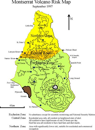
Montserrat Eruption = Monster rat
 Montserrat Eruption 1997 = Monster rat Small island in the Caribbean sea Montserrat is a small... Soufriere Hills volcano Key facts: Date: 25 th June 1997 (small eruptions began in July 1995) Size: 4.5
Earth s Changing Surface
 Earth s Changing Surface Earthquakes and Volcanoes Key Concepts What causes earthquakes? What causes volcanoes to form? How do earthquakes and volcanoes change Earth s surface? What do you think? Read
Virtual Design Center Deliverable 4-2: Three Levels of Assessment
 Virtual Design Center Deliverable 4-2: Three Levels of Assessment Project Name Operation Montserrat Test Questions 1. Which of these is an immediate result of the movement of tectonic plates: a) Ocean