3D Seismic Hazard and Risk Maps for Earthquake Awareness of Citizens with Aids of GIS and Remote Sensing Technologies
|
|
|
- Mildred Mason
- 6 years ago
- Views:
Transcription

1 3D Seismic Hazard and Risk Maps for Earthquake Awareness of Citizens with Aids of GIS and Remote Sensing Technologies Saburoh Midorikawa Tokyo Institute of Technology In Japan, seismic hazard and risk maps have been published by central and local governments. The objectives of the mapping are for planning of earthquake mitigation programs, for earthquake resistant design, and for earthquake awareness of citizens. One of the mapping projects is the National Seismic Hazard Mapping Project of Japan by the Headquarters for Earthquake Research Promotion. The regional mapping projects by local governments are also carried out to publish the detailed maps for citizens.
 Deterministic Ground Shaking Map (Scenario Earthquake Ground Shaking Map) 2) Probabilistic Ground Shaking Map (Probabilistic")

2 National Seismic Hazard Mapping Project The project started in 1999 and the maps have been published on March, The maps consist of 1) Deterministic Ground Shaking Map (Scenario Earthquake Ground Shaking Map) 2) Probabilistic Ground Shaking Map (Probabilistic Seismic Hazard Map) Scenario Earthquake Ground Shaking Map The source model is established for a scenario earthquake, considering asperities with larger slip and higher stress drop on the fault plane. The time history of ground motion is computed, and then converted to the seismic intensity. Asperity Source Model Time History Seismic Intensity Map


3 Deterministic maps have been published for thirteen scenario earthquakes which have high potential of occurrence or may give high impact to urban areas. Probabilistic Seismic Hazard Map Earthquake Occurrence Model for Different Types of Earthquakes Probability of Exceedance Attenuation Relationship of Ground Motion Intensity Hazard Curves for Different Types of Earthquakes Hazard Curve at a Site Ground Motion Intensity Hazard Map
 Is my house in the red")


4 When a citizen look the seismic hazard map, he thinks that; 1) Is my house in the red zone? 2) If my house is in the red zone, what should I do? 2000) (after Olshansky, The national seismic hazard maps are too large in scale, and difficult to catch citizen s strong interest.


")

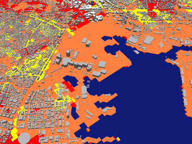
5 BASIC MAP National Seismic Hazard Map ADVANCED MAP Yokohama Shake Map Project 2001 Yokohama City Population 3,500,000 TOKYO YOKOHAMA Collection and Compilation of Boring Data (more than 15,000 data) Construction of Soil Profile Model for 50m Micro-Mesh Shake Map with 50m Micro-Mesh


6 Close-up of Shake Map 50 Mesh INCENTIVE POLICIES OF YOKOHAMA FOR SEISMIC RETROFIT 1. FREE SEISMIC PERFORMANCE APPRAISAL FOR OLDER WOODEN HOUSES 2. SEISMIC RETROFIT SUBSIDIES (up to 1,700,000 for average income household and 4,500,000 for low-income household)

7 EFFCTS OF SHAKE MAP Seismic Performance Appraisal Before 1,000 applicants per year, After 2,000 applicants per year. Seismic Retrofit Subsidies Before 70 applicants per year, After 150 applicant per year. Success of the Yokohama map stimulated the other governments. On August 2004, the city of Nagoya published Seismic Hazard Town Map and distributed to all households in the city.


8 The department of disaster management at the Cabinet Office has also published the detailed maps for nine municipalities as the case studies on January Web-GIS Yokohama Hazard & Risk Maps January, 2005)


9 They print the map, and walk around our region to check their environments. They write in hazardous points and safety facilities in the map, and paste their photos on the map to create their own disaster preparedness map. To get stronger interest of citizens, 3D Presentation will be effective.


10 Digital City with DEM by Laser Profiler and GIS Building Data 3D Presentation of Shake Map in Digital City
11 Concluding Remarks In Japan, seismic hazard and risk maps have been published by central and local governments. The maps, however, may not be attractive to catch strong interest of citizens. The 3-D presentation with aids of GIS and Remote Sensing technologies will be effective to educate citizens for earthquake awareness. Damage in the Northridge earthquake was lower when local governments paid more attention to enforcement of the seismic provisions and to public awareness (Burby, 1998).


12 About 100,000 copies are printed and distributed to citizens. Seminars on the map for citizens are carried out.
13
Japan Seismic Hazard Information Station
 Japan Seismic Hazard Information Station (J-SHIS) Hiroyuki Fujiwara National Research Institute for Earth Science and Disaster Prevention (NIED) Background of the Project Headquarters for Earthquake Research
REAL-TIME ASSESSMENT OF EARTHQUAKE DISASTER IN YOKOHAMA BASED ON DENSE STRONG-MOTION NETWORK
 REAL-TIME ASSESSMENT OF EARTHQUAKE DISASTER IN YOKOHAMA BASED ON DENSE STRONG-MOTION NETWORK Saburoh MIDORIKAWA 1 And Susumu ABE 2 SUMMARY This paper describes a system for REal-time Assessment of earthquake
Some Problems Related to Empirical Predictions of Strong Motion
 Bull. Earthq. Res. Inst. Univ. Tokyo Vol. 2+,**0 pp.,/-,/2 Some Problems Related to Empirical Predictions of Strong Motion Saburoh Midorikawa + * + Center for Urban Earthquake Engineering, Tokyo Institute
Uncertainty in the assessment of seismic hazard
 The 3rd annual meeting of the seismic hazard assessment for the next generation map China-Japan-Korea cooperative program June 17 21, 2013, in Sendai, Japan Uncertainty in the assessment of seismic hazard
Chapter 2 Land Use Management and Risk Communication
 Chapter 2 Land Use Management and Risk Communication Michiko Banba Abstract Land use represents a relationship between natural and urban environment. Land use management is the way of managing land use
PREDICTION OF AVERAGE SHEAR-WAVE VELOCITY FOR GROUND SHAKING MAPPING USING THE DIGITAL NATIONAL LAND INFORMATION OF JAPAN
 th World Conference on Earthquake Engineering Vancouver, B.C., Canada August -6, 00 Paper No. 07 PREDICTION OF AVERAGE SHEAR-WAVE VELOCITY FOR GROUND SHAKING MAPPING USING THE DIGITAL NATIONAL LAND INFORMATION
Seismic Activity and Crustal Deformation after the 2011 Off the Pacific Coast of Tohoku Earthquake
 J-RAPID Symposium March 6-7, 2013 Seismic Activity and Crustal Deformation after the 2011 Off the Pacific Coast of Tohoku Earthquake Y. Honkura Tokyo Institute of Technology Japan Science and Technology
Seismic Hazard Abatement Program
 Seismic Hazard Abatement Program Recommendations To take the first steps toward a seismic mitigation program for older existing buildings To improve our current regulatory system for implementation of
PROBABILISTIC LIQUEFACTION HAZARD ANALYSIS IN JAPAN
 SECED 2015 Conference: Earthquake Risk and Engineering towards a Resilient World 9-10 July 2015, Cambridge UK PROBABILISTIC LIQUEFACTION HAZARD ANALYSIS IN JAPAN Tetsushi KURITA 1 and Sei ichiro FUKUSHIMA
A Study on the Risk Assessment of Emergency Supplies. Transportation Routes Considering Scenario Earthquakes
 ORIGINAL ARTICLE A Study on the Risk Assessment of Emergency Supplies Transportation s Considering Scenario Earthquakes Kazuaki Torisawa 1, Harumi Yashiro 2, Sei ichiro Fukushima 3*, Satoshi Kina 4 1 Kajima
The Current Activities of the Headquarters for Earthquake Research Promotion Concerning Tonankai/Nankai Earthquakes
 The Current Activities of the Headquarters for Earthquake Research Promotion Concerning Tonankai/Nankai Earthquakes ISOGAI Keisuke Director of Earthquake Research Division, Research and Development Bureau,
Scenario Earthquake Shaking Maps in Japan
 1 Scenario Earthquake Shaking Maps in Japan Nobuyuki Morikawa National Research Institute for Earth Science and Disaster Prevention (NIED), JAPAN Scenario Earthquake Shaking Maps (SESMs) The shaking maps
ENGINEERING-SEISMOLOGICAL ASPECTS OF EARTHQUAKE SCENARIO DEVELOPMENT ON THE EXAMPLE OF TASHKENT, UZBEKISTAN
 International Journal of Geology, Earth & Environmental Sciences ISSN: 2277-281 (Online) 218 Vol. 8 (2) May-August, pp. 3-35/Alixanovich ENGINEERING-SEISMOLOGICAL ASPECTS OF EARTHQUAKE SCENARIO DEVELOPMENT
Earthquake Source. Kazuki Koketsu. Special Session: Great East Japan (Tohoku) Earthquake. Earthquake Research Institute, University of Tokyo
 Earthquake. Earthquake Research Institute, University of Tokyo") 2012/9/24 17:20-17:35 WCEE SS24.4 Special Session: Great East Japan (Tohoku) Earthquake Earthquake Source Kazuki Koketsu Earthquake Research Institute, University of Tokyo 1 Names and features of the earthquake
2012/9/24 17:20-17:35 WCEE SS24.4 Special Session: Great East Japan (Tohoku) Earthquake Earthquake Source Kazuki Koketsu Earthquake Research Institute, University of Tokyo 1 Names and features of the earthquake
KNOWLEDGE NOTE 5-1. Risk Assessment and Hazard Mapping. CLUSTER 5: Hazard and Risk Information and Decision Making. Public Disclosure Authorized
 Public Disclosure Authorized Public Disclosure Authorized Public Disclosure Authorized Public Disclosure Authorized KNOWLEDGE NOTE 5-1 CLUSTER 5: Hazard and Risk Information and Decision Making Risk Assessment
AUTOMATED BUILDING DETECTION FROM HIGH-RESOLUTION SATELLITE IMAGE FOR UPDATING GIS BUILDING INVENTORY DATA
 13th World Conference on Earthquake Engineering Vancouver, B.C., Canada August 1-6, 2004 Paper No. 678 AUTOMATED BUILDING DETECTION FROM HIGH-RESOLUTION SATELLITE IMAGE FOR UPDATING GIS BUILDING INVENTORY
Application of a GIS for Earthquake Hazard Assessment and Risk Mitigation in Vietnam
 Application of a GIS for Earthquake Hazard Assessment and Risk Mitigation in Vietnam Nguyen Hong Phuong Earthquake Information and Tsunami Warning Centre, VAST OUTLINE Introduction Fault Source Model and
COMPREHENSIVE GIS-BASED SOLUTION FOR ROAD BLOCKAGE DUE TO SEISMIC BUILDING COLLAPSE IN TEHRAN
 COMPREHENSIVE GIS-BASED SOLUTION FOR ROAD BLOCKAGE DUE TO SEISMIC BUILDING COLLAPSE IN TEHRAN B. Mansouri 1, R. Nourjou 2 and K.A. Hosseini 3 1 Assistant Professor, Dept. of Emergency Management, International
"The Natural Disasters, like The Sumatra Tsunami had taught us before -BUT" U Than Myint President Myanmar Engineering Society
 "The Natural Disasters, like The Sumatra Tsunami had taught us before -BUT" U Than Myint President Myanmar Engineering Society Present Day Regional Tectonic Setting of South East Asia Tsunami-generated
Usually, only a couple of centuries of earthquake data is available, much shorter than the complete seismic cycle for most plate motions.
 Earthquake Hazard Analysis estimate the hazard presented by earthquakes in a given region Hazard analysis is related to long term prediction and provides a basis to expressed hazard in probabilistic terms.
Measuring Disaster Risk for Urban areas in Asia-Pacific
 Measuring Disaster Risk for Urban areas in Asia-Pacific Acknowledgement: Trevor Clifford, Intl Consultant 1 SDG 11 Make cities and human settlements inclusive, safe, resilient and sustainable 11.1: By
Project on Seismic Hazard & Vulnerability. areas, Bangladesh. Mohammad Ashraful Kamal (Geologist)
") Project on Seismic Hazard & Vulnerability Assessment in Dhaka, Chittagong & Sylhet city areas, Bangladesh By Mohammad Ashraful Kamal (Geologist) Tectonic & Seismic zoning map of Bangladesh Geological map
Project on Seismic Hazard & Vulnerability Assessment in Dhaka, Chittagong & Sylhet city areas, Bangladesh By Mohammad Ashraful Kamal (Geologist) Tectonic & Seismic zoning map of Bangladesh Geological map
SEISMIC RISK ANALYSIS FOR CITY GAS NETWORK IN SOUTHERN KANTO AREA, JAPAN ABSTRACT
 Proceedings of the 8 th U.S. National Conference on Earthquake Engineering April 18-22, 2006, San Francisco, California, USA Paper No. 1228 SEISMIC RISK ANALYSIS FOR CITY GAS NETWORK IN SOUTHERN KANTO
NGIAs' roles in successful disaster response
 The Second UN-GGIM-AP Plenary Meeting NGIAs' roles in successful disaster response Japan Teheran Iran 28 October 2013 Shin-ichi SAKABE, Director of International Affairs Division Geospatial Information
The Development of the Slope Failure Management System
 FANG Ji, Akiyuki KAWASAKI, Satoru SADOHARA The Development of the Slope Failure Management System There are many incidents of slope failure across Japan. The measures are required. Recently soft-measures
Disaster Risk Assessment: Opportunities for GIS and data management with Open DRI
 Disaster Risk Assessment: Opportunities for GIS and data management with Open DRI Jacob Opadeyi Department of Geomatics Engineering and Land Management, The University of the West Indies, St. Augustine,
Information analysis and risk management by cartography
 Information analysis and risk management by cartography Keiichi ISHIDA ABSG Consulting Inc. Tokyo Japan kishida@absconsulting.co.jp Propose: I propose the usage of cartography as an information analysis
Geo-hazard Potential Mapping Using GIS and Artificial Intelligence
 Geo-hazard Potential Mapping Using GIS and Artificial Intelligence Theoretical Background and Uses Case from Namibia Andreas Knobloch 1, Dr Andreas Barth 1, Ellen Dickmayer 1, Israel Hasheela 2, Andreas
PROBABILISTIC SEISMIC HAZARD MAPS AT GROUND SURFACE IN JAPAN BASED ON SITE EFFECTS ESTIMATED FROM OBSERVED STRONG-MOTION RECORDS
 13 th World Conference on Earthquake Engineering Vancouver, B.C., Canada August 1-6, 2004 Paper No. 3488 PROBABILISTIC SEISMIC HAZARD MAPS AT GROUND SURFACE IN JAPAN BASED ON SITE EFFECTS ESTIMATED FROM
Earthquake Hazard Analysis Methods: A Review
 IOP Conference Series: Earth and Environmental Science PAPER OPEN ACCESS Earthquake Hazard Analysis Methods: A Review To cite this article: A M Sari and A Fakhrurrozi 2018 IOP Conf. Ser.: Earth Environ.
EARTHQUAKE HAZARD ASSESSMENT IN KAZAKHSTAN
 EARTHQUAKE HAZARD ASSESSMENT IN KAZAKHSTAN Dr Ilaria Mosca 1 and Dr Natalya Silacheva 2 1 British Geological Survey, Edinburgh (UK) imosca@nerc.ac.uk 2 Institute of Seismology, Almaty (Kazakhstan) silacheva_nat@mail.ru
Guidelines for Site-Specific Seismic Hazard Reports for Essential and Hazardous Facilities and Major and Special-Occupancy Structures in Oregon
 Guidelines for Site-Specific Seismic Hazard Reports for Essential and Hazardous Facilities and Major and Special-Occupancy Structures in Oregon By the Oregon Board of Geologist Examiners and the Oregon
Borah Peak Earthquake HAZUS Scenario Project Executive Summary Idaho Bureau of Homeland Security Idaho Geological Survey Western States Seismic
 Borah Peak Earthquake HAZUS Scenario Project Executive Summary Idaho Bureau of Homeland Security Idaho Geological Survey Western States Seismic Policy Council 12/30/2008 The HAZUS-MH analysis of the Borah
Final Presentation on Disaster Risk Management in Japan. Through ADRC V. R Programme. Main Findings and Action Plan:
 Final Presentation on Disaster Risk Management in Japan Through ADRC V. R Programme Main Findings and Action Plan: Problem/Hazard and Disaster in Japan Good Practiced on Disaster Risk Management in Japan
Earthquakes. & Expansive Soils
 Earthquakes & Expansive Soils January 22, 2009 Plan Update Flanagan & Associates, LLC Consultants Tulsa, OK www.rdflanagan.com rdflanagan@rdflanagan.com Plan can be reviewed at: www.rdflanagan.com/.html
ACTIVITIES OF THE HEADQUARTERS FOR EARTHQUAKE RESEARCH PROMOTION
 Journal of Japan Association for Earthquake Engineering, Vol.4, No.3 (Special Issue), 2004 ACTIVITIES OF THE HEADQUARTERS FOR EARTHQUAKE RESEARCH PROMOTION Sadanori HIGASHI 1 1 Member of JAEE, Earthquake
5. Probabilistic Seismic Hazard Analysis
 Probabilistic Seismic Hazard Analysis (PSHA) proposed by C.A. Cornell (1968) used to determine the design earthquake for all locations in USA. PSHA gives a relative quantification i of the design earthquake,
To estimate damage ratios of water and gas distribution pipes, fragility curves were empirically obtained based on damage datasets after the 1995 Kobe
 Proceedings of the 9th U.S. National and 10th Canadian Conference on Earthquake Engineering Compte Rendu de la 9ième Conférence Nationale Américaine et 10ième Conférence Canadienne de Génie Parasismique
Geographic Information Systems
 Geographic Information Systems What is a Geographic Information System (GIS)? definition of GIS - An internally referenced, automated, spatial information system for data mapping, management, and analysis
SEISMIC HAZARD ASSESSMENT FOR JAPAN AFTER THE 2011 TOHOKU-OKI MEGA-THRUST EARTHQUAKE (Mw9.0)
") Proceedings of the International Symposium on Engineering Lessons Learned from the 2011 Great East Japan Earthquake, March 1-4, 2012, Tokyo, Japan SEISMIC HAZARD ASSESSMENT FOR JAPAN AFTER THE 2011 TOHOKU-OKI
Proceedings of the International Symposium on Engineering Lessons Learned from the 2011 Great East Japan Earthquake, March 1-4, 2012, Tokyo, Japan SEISMIC HAZARD ASSESSMENT FOR JAPAN AFTER THE 2011 TOHOKU-OKI
Application of high-resolution (10 m) DEM on Flood Disaster in 3D-GIS
 DEM on Flood Disaster in 3D-GIS") Risk Analysis V: Simulation and Hazard Mitigation 263 Application of high-resolution (10 m) DEM on Flood Disaster in 3D-GIS M. Mori Department of Information and Computer Science, Kinki University, Japan
Risk Analysis V: Simulation and Hazard Mitigation 263 Application of high-resolution (10 m) DEM on Flood Disaster in 3D-GIS M. Mori Department of Information and Computer Science, Kinki University, Japan
Xiang Wen, & Takahashi Toru Chiba University, Chiba City, Japan. Katada Masaki Kyoto University, Kyoto, Japan
 Damage Scenario and Its Reduction for Nishi-Chiba Campus, Chiba University due to Tokai, Tonankai, Nankai Coupled Earthquake and The Capital, Tokyo Inland Earthquake Xiang Wen, & Takahashi Toru Chiba University,
New Seismic Activity Model of Large Earthquakes along Nankai Trough for Probabilistic Seismic Hazard Maps
 New Seismic Activity Model of Large Earthquakes along Nankai Trough for Probabilistic Seismic Hazard Maps Toshihiko Okumura (Shimizu Corp.) Hiroyuki Fujiwara (NIED) Plate Tectonics around Japan Pacific
Scenario Earthquake Shaking Maps in Japan
 Scenario Earthquake Shaking Maps in Japan Nobuyuki Morikawa National Research Institute for Earth Science and Disaster Prevention (NIED), JAPAN Example of SESMs The Kego fault zone (south-east part) The
Progress Report. Flood Hazard Mapping in Thailand
 Progress Report Flood Hazard Mapping in Thailand Prepared By: Mr. PAITOON NAKTAE Chief of Safety Standard sub-beuro Disaster Prevention beuro Department of Disaster Prevention and Mitigation THAILAND E-mail:
Mechanism of tsunami generation,propagation and runup -sharing experiences with Japanese
 Mechanism of tsunami generation,propagation and runup -sharing experiences with Japanese Mechanism of tsunami generation Predicting the propagation, runup and inundation of tsunamis Near and far-field
2 Approaches To Developing Design Ground Motions
 2 Approaches To Developing Design Ground Motions There are two basic approaches to developing design ground motions that are commonly used in practice: deterministic and probabilistic. While both approaches
Training System and Information Network for Earthquake Disaster Mitigation. Taiki SAITO. Building Research Institute (BRI)
") 1 Training System and Information Network for Earthquake Disaster Mitigation Taiki SAITO Chief Research Engineer, International Institute of Seismology and Earthquake Engineering (IISEE), Building Research
1 Training System and Information Network for Earthquake Disaster Mitigation Taiki SAITO Chief Research Engineer, International Institute of Seismology and Earthquake Engineering (IISEE), Building Research
Georeferencing and Satellite Image Support: Lessons learned, Challenges and Opportunities
 Georeferencing and Satellite Image Support: Lessons learned, Challenges and Opportunities Shirish Ravan shirish.ravan@unoosa.org UN-SPIDER United Nations Office for Outer Space Affairs (UNOOSA) UN-SPIDER
DOWNLOAD OR READ : GIS BASED FLOOD LOSS ESTIMATION MODELING IN JAPAN PDF EBOOK EPUB MOBI
 DOWNLOAD OR READ : GIS BASED FLOOD LOSS ESTIMATION MODELING IN JAPAN PDF EBOOK EPUB MOBI Page 1 Page 2 gis based flood loss estimation modeling in japan gis based flood loss pdf gis based flood loss estimation
RELATIONSHIP BETWEEN AGE OF GROUND AND LIQUEFACTION OCCURRENCE IN THE 2011 GREAT EAST JAPAN EARTHQUAKE
 Proceedings of the International Symposium on Engineering Lessons Learned from the 2011 Great East Japan Earthquake, March 1-4, 2012, Tokyo, Japan RELATIONSHIP BETWEEN AGE OF GROUND AND LIQUEFACTION OCCURRENCE
In the early morning hours of
 Figure 1. Brace that Chimney! Bracing of masonry chimneys is very difficult to do properly and has generally been ineffective in preventing their failure during earthquakes. While replacement of the chimney
GIS present situation in Japan
 GIS present situation in Japan September 26, 2006 INTERPREVENT 2006 in Niigata University Geographic Information Analysis Research Div. Geography and Crustal Dynamics Research Senter Geographical Survey
SUVA EARTHQUAKE RISK MANAGEMENT SCENARIO PILOT PROJECT (SERMP)
") SUVA EARTHQUAKE RISK MANAGEMENT SCENARIO PILOT PROJECT (SERMP) Jack RYNN 1, Josefa SERULAGILAGI 2, Atu KALOUMARIA 3 And Allan HULL 4 SUMMARY (Presented on behalf of the Government of the Republic of Fiji;
SUVA EARTHQUAKE RISK MANAGEMENT SCENARIO PILOT PROJECT (SERMP) Jack RYNN 1, Josefa SERULAGILAGI 2, Atu KALOUMARIA 3 And Allan HULL 4 SUMMARY (Presented on behalf of the Government of the Republic of Fiji;
Downtown Anchorage Seismic Risk Assessment & Land Use Regulations to Mitigate Seismic Risk
 Prepared for: The Municipality of Anchorage Planning Department and the Geotechnical Advisory Commission Downtown Anchorage Seismic Risk Assessment & Land Use Regulations to Mitigate Seismic Risk Prepared
REPORT ON THE TOHOKU AREA PASIFIC OFFSHORE EARTHQUAKE
 REPORT ON THE TOHOKU AREA PASIFIC OFFSHORE EARTHQUAKE GENERAL PERSPECTIVE The Highest Magnitude Ever Recorded The 2011 off the Pacific Coast of Tohoku Earthquake (hereafter, the 2011 Tohoku- Pacific Earthquake
CHAPTER 3 METHODOLOGY
 32 CHAPTER 3 METHODOLOGY 3.1 GENERAL In 1910, the seismological society of America identified the three groups of earthquake problems, the associated ground motions and the effect on structures. Indeed
Estimation of Damage Ratios of Wooden Houses and Water Distribution Pipelines in an Earthquake Scenario for the Tokyo Metropolitan Region
 The 2011 World Congress on Advances in Structural Engineering and Mechanics (ASEM'11 + ) Seoul, Korea, 18-22 September, 2011 Estimation of Damage Ratios of Wooden Houses and Water Distribution Pipelines
RECENT ACTIVITIES OF JST-JICA PROJECT ON EARTHQUAKE AND TSUNAMI DISASTER MITIGATION IN PERU
 JOINT CONFERENCE PROCEEDINGS 9th International Conference on Urban Earthquake Engineering/ 4th Asia Conference on Earthquake Engineering March 6-8, 2012, Tokyo Institute of Technology, Tokyo, Japan RECENT
INTEGRATING CLIMATE VULNERABILITY & RISK ASSESSMENT INTO URBAN SPATIAL PLANNING PROCESS
 INTEGRATING CLIMATE VULNERABILITY & RISK ASSESSMENT INTO URBAN SPATIAL PLANNING PROCESS (CASE STUDY: BLITAR CITY, EAST JAVA, INDONESIA) SHINTA MICHIKO PUTERI, ST, MT. DR. IR. DENNY ZULKAIDI, MUP. WRITER
Actual practices of seismic strong motion estimation at NPP sites
 ANSN Regional Workshop on Site Selection and Evaluation for Nuclear Power Plants June 2010, Hanoi Vietnam IAEA/ISSC Actual practices of seismic strong motion estimation at NPP sites Yoshi. FUKUSHIMA (JNES)
JMA Tsunami Warning Services. Tomoaki OZAKI Senior Coordinator for Tsunami Forecast Modeling Japan Meteorological Agency
 JMA Tsunami Warning Services Tomoaki OZAKI Senior Coordinator for Tsunami Forecast Modeling Japan Meteorological Agency Organization Chart of the Government of Japan Cabinet Office Diet Ministry of Internal
ESTIMATING LAND VALUE AND DISASTER RISK IN URBAN AREA IN YANGON, MYANMAR USING STEREO HIGH-RESOLUTION IMAGES AND MULTI-TEMPORAL LANDSAT IMAGES
 ESTIMATING LAND VALUE AND DISASTER RISK IN URBAN AREA IN YANGON, MYANMAR USING STEREO HIGH-RESOLUTION IMAGES AND MULTI-TEMPORAL LANDSAT IMAGES Tanakorn Sritarapipat 1 and Wataru Takeuchi 1 1 Institute
Earthquake Hazards in Douglas County
 Earthquake Hazards in Douglas County Craig M. depolo Nevada Bureau of Mines and Geology Nevada Hazard Mitigation Planning Committee August 9, 2012 Earthquake Truths The consequences of bad earthquakes
Baldwin County, Alabama
 2015 Baldwin County, Alabama Multi-Hazard Mitigation Plan I. Comprehensive Plan A multi-jurisdiction plan City of Bay Minette City of Daphne Town of Elberta City of Fairhope City of Foley City of Gulf
Assessment and Mitigation of Ground Motion Hazards from Induced Seismicity. Gail M. Atkinson
 Assessment and Mitigation of Ground Motion Hazards from Induced Seismicity Gail M. Atkinson (with acknowledgement to many collaborators, especially Ghofrani and Assatourians) NSERC/TransAlta/Nanometrics
The Role of Geospatial Information in Disaster Risk Reduction
 3rd High Level Forum on UN Global Geospatial Information Management in Beijing, Session 3: Climate Change and Disaster Mitigation 23 October 2014 The Role of Geospatial Information in Disaster Risk Reduction
BROADBAND STRONG MOTION SIMULATION OF THE 2004 NIIGATA- KEN CHUETSU EARTHQUAKE: SOURCE AND SITE EFFECTS
 Third International Symposium on the Effects of Surface Geology on Seismic Motion Grenoble, France, 30 August - 1 September 2006 Paper Number: 105 BROADBAND STRONG MOTION SIMULATION OF THE 2004 NIIGATA-
Preliminary Earthquake Risk Management Strategy Plan of Eskisehir, Turkey by using GIS
 Preliminary Earthquake Risk Management Strategy Plan of Eskisehir, Turkey by using GIS Metin Altan, Ferah Özturk and Can Ayday Space and Satellite Sciences Research Institute Anadolu University, TURKEY
A Feasibility Study about Extraction Method of Densely Crowded Areaswith Wooden Buildings in the KOBE Government. Part II 1)
") A Feasibility Study about Extraction Method of Densely Crowded Areaswith Wooden Buildings in the KOBE Government. Part II 1) Consideration of evaluation of urban fire hazard. Ritsu KATAYAMA Dept. of Architecture,
A Feasibility Study about Extraction Method of Densely Crowded Areaswith Wooden Buildings in the KOBE Government. Part II 1) Consideration of evaluation of urban fire hazard. Ritsu KATAYAMA Dept. of Architecture,
Interpretive Map Series 24
 Oregon Department of Geology and Mineral Industries Interpretive Map Series 24 Geologic Hazards, Earthquake and Landslide Hazard Maps, and Future Earthquake Damage Estimates for Six Counties in the Mid/Southern
Tectonic Processes and Hazards Enquiry Question 1: Why are some locations more at risk from tectonic hazards?
 Tectonic Processes and Hazards Enquiry Question 1: Why are some locations more at risk from tectonic hazards? Key words Basalt Andesite Rhyolite Benioff Zone Subduction zone Crustal fracturing Definition
ENSURE. Coordinator: Hormoz MODARESSI Website:
 ENSURE Coordinator: Hormoz MODARESSI h.modaressi@brgm.fr Website: http://ensureproject.eu/ The project is financed by the European Commission under the 7th Framework Programme for Research and Technological
APPLICATON OF SEAMLESS SIMULATION OF SEISMIC RESPONSE ANALYSIS AND HIGH RESOLUTION TSUNAMI SIMULATION TO COASTAL AREA OF SENDAI
 Proceedings of the International Symposium on Engineering Lessons Learned from the 2011 Great East Japan Earthquake, March 1-4, 2012, Tokyo, Japan APPLICATON OF SEAMLESS SIMULATION OF SEISMIC RESPONSE
CHARACTERISTICS OF STRONG GROUND MOTION FROM THE 2011 GIGANTIC TOHOKU, JAPAN EARTHQUAKE
 Paper No. M-4 CHARACTERISTICS OF STRONG GROUND MOTION FROM THE 2011 GIGANTIC TOHOKU, JAPAN EARTHQUAKE Saburoh MIDORIKAWA 1, Hiroyuki MIURA 2 and Tomohiro ATSUMI 3 SUMMARY The 2011 Tohoku earthquake (Mw9.0)
- Information before strong ground motion -
 -Earthquake Early Warning - Information before strong ground motion - Mitsuyuki HOSHIBA Japan Meteorological Agency January 12, 2007 1 Distribution of Earthquakes Causing Tsunami (1896~2004) in Japan Distribution
Hazard Resilience Index (HRI) Earthquakes, Tsunamis, and Volcanoes
 Earthquakes, Tsunamis, and Volcanoes") Hazard Index (HRI) Earthquakes, Tsunamis, and Volcanoes Earthquakes Tsunamis Volcano-Ash Falls, Projectiles and Lateral Blasts, Pyroclastic Flows and Lava Flows Earthquakes, Tsunamis and Volcanoes Please
Hazard Index (HRI) Earthquakes, Tsunamis, and Volcanoes Earthquakes Tsunamis Volcano-Ash Falls, Projectiles and Lateral Blasts, Pyroclastic Flows and Lava Flows Earthquakes, Tsunamis and Volcanoes Please
Promoting Sustainable Use of Natural Resources through Restoring and Conserving Socio-Ecological Production Landscapes in Cambodia
 IPSI Public Forum presentations, 13-14 March 2012, Nairobi, Kenya Promoting Sustainable Use of Natural Resources through Restoring and Conserving Socio-Ecological Production Landscapes in Cambodia By Institute
Reducing Vulnerability to Extreme Heat: Science-Policy Interface
 Reducing Vulnerability to Extreme Heat: Science-Policy Interface Olga Wilhelmi, Mary Hayden, Jennifer Boehnert, Ursula Lauper and SIMMER research team October 23, 2013 Toronto SIMMER workshop Science-Policy
A METHODOLOGY FOR ASSESSING EARTHQUAKE-INDUCED LANDSLIDE RISK. Agency for the Environmental Protection, ITALY (
 A METHODOLOGY FOR ASSESSING EARTHQUAKE-INDUCED LANDSLIDE RISK Roberto W. Romeo 1, Randall W. Jibson 2 & Antonio Pugliese 3 1 University of Urbino, ITALY (e-mail: rwromeo@uniurb.it) 2 U.S. Geological Survey
Case Studies on Mega Cities
 Case Studies on Mega Cities Paul Kelly Director, Spatial Strategies Pty Ltd Vice Chair FIG Commission 3 The Case Study Cities Hong Kong SAR, China (Q) Tokyo, Japan (Q) Seoul, Korea (Q) Istanbul, Turkey
held on 4 June 2013 Prof. Yoshimori Honkura, Program Officer of Japan Science and Technology Agency (JST) Jakarta, Indonesia Pan Pacific Hotel)
 Jakarta, Indonesia Pan Pacific Hotel)") Overview of the Outcomes from e-asia JRP Disaster Prevention Workshop held on 4 June 2013 Prof. Yoshimori Honkura, Program Officer of Japan Science and Technology Agency (JST) Jakarta, Indonesia (@Sari
Overview of the Outcomes from e-asia JRP Disaster Prevention Workshop held on 4 June 2013 Prof. Yoshimori Honkura, Program Officer of Japan Science and Technology Agency (JST) Jakarta, Indonesia (@Sari
Operational Earthquake Forecasting: Proposed Guidelines for Implementation
 Operational Earthquake Forecasting: Proposed Guidelines for Implementation Thomas H. Jordan Director, Southern California S33D-01, AGU Meeting 14 December 2010 Operational Earthquake Forecasting Authoritative
4-3-1 Earthquake and Tsunami Countermeasures of Tokyo s
 4-3-1 Earthquake and Tsunami Countermeasures of Tokyo s Sewerage Masahiro Hikino* and Gaku Sato** *Planning Section, Planning and Coordinating Division, Bureau of Sewerage, Tokyo Metropolitan Government
2014 Russell County Hazard Mitigation Plan Update STAKEHOLDERS AND TECHNICAL ADVISORS MEETING 2/6/14
 2014 Russell County Hazard Mitigation Plan Update STAKEHOLDERS AND TECHNICAL ADVISORS MEETING 2/6/14 Welcome and Introductions We cannot direct the wind, but we can adjust our sails. 44 CFR 201.6; Local
A Simple Method for Producing Probabilistic Seismic Shallow Landslide Hazard Maps
 Disaster Mitigation of Debris Flows, Slope Failures and Landslides 529 A Simple Method for Producing Probabilistic Seismic Shallow Landslide Hazard Maps Taro Uchida, 1) Nobutomo Osanai, 2) Satoshi Onoda,
at IHO IRCC7 Mexico City, Mexico, June 2015
 Report on Japan s Response to Disasters presented by JHOD at IHO IRCC7 Mexico City, Mexico, 01 03 June 2015 JAPAN COAST GUARD Actions against huge earthquake Actions taken by JHOD against the Great East
Purpose of the seminar
 Earthquake disaster preparedness June 24, 2008 Koshun Yamaoka Research Center for Seismology, Volcanology and Disaster Mitigation Graduate School of Environmental Studies Nagoya University Purpose of the
Enhancement of Earthquake and Tsunami
 Science and Technology Research Partnership for Sustainable Development t(satreps) Enhancement of Earthquake and Tsunami Disaster Mitigation Technology in Peru -Research Plan- January 2010 Principal Investigator:
9. GEOLOGY, SOILS, AND MINERALS
 June 28, 2018 Page 9-1 9. GEOLOGY, SOILS, AND MINERALS This EIR chapter describes the existing geological, soil, and mineral conditions in the planning area. The chapter includes the regulatory framework
Applying Hazard Maps to Urban Planning
 Applying Hazard Maps to Urban Planning September 10th, 2014 SAKAI Yuko Disaster Management Expert JICA Study Team for the Metro Cebu Roadmap Study on the Sustainable Urban Development 1 Contents 1. Outline
DAMAGE ANALYSIS OF WATER SUPPLY PIPES DUE TO THE 2004 NIIGATA-KEN CHUETSU, JAPAN EARTHQUAKE ABSTRACT
 Proceedings of the 8 th U.S. National Conference on Earthquake Engineering April 18-22, 2006, San Francisco, California, USA Paper No. 1163 DAMAGE ANALYSIS OF WATER SUPPLY PIPES DUE TO THE 2004 NIIGATA-KEN
Introduction. Thematic Mapping for Disaster Risk Assessment in Case of Earthquake FIG Working Week
 Thematic Mapping for Disaster Risk Assessment in Case of Earthquake Silvia MARINOVA, Temenoujka BANDROVA, Mihaela KOUTEVA-GUENTCHEVA, Stefan BONCHEV University of Architecture, Civil Engineering and Geodesy
CONTROLLING FACTORS OF STRONG GROUND MOTION PREDICTION FOR SCENARIO EARTHQUAKES
 13 th World Conference on Earthquake Engineering Vancouver, B.C., Canada August 1-6, 2004 Paper No. 2801 CONTROLLING FACTORS OF STRONG GROUND MOTION PREDICTION FOR SCENARIO EARTHQUAKES Hiroe MIYAKE 1,
Individual Self-help Housing Reconstruction with Relocation: Transformation of Built Environment after the Great East Japan Earthquake
 Individual Self-help Housing Reconstruction with Relocation: Transformation of Built Environment after the Great East Japan Earthquake Tamiyo Kondo, Kobe University tamiyok@people.kobe-u.ac.jp Yuka Karatani,
Proposing Effective Method to Develop Common Operational Picture in Disaster Response Utilizing Cloud-based Geospatial Infrastructure
 Proposing Effective Method to Develop Common Operational Picture in Disaster Response Utilizing Cloud-based Geospatial Infrastructure Munenari Inoguchi Research Institute for Natural Hazard & Disaster
Probabilistic Seismic Hazard Maps in Dam Foundation
 Probabilistic Seismic Hazard Maps in Dam Foundation by Hideaki Kawasaki 1, Masafumi Kondo 2, Akira Nakamura 3, Kenji Inagaki 4 ABSTRACT Because Japan is one of the world s most earthquake prone countries,
2014 Annual Mitigation Plan Review Meeting
 2014 Annual Mitigation Plan Review Meeting Highland County EMA MEETING OBJECTIVES Understand Your Natural Disaster Risk Review of Previous Plans Current Plan Status Future Activity Plan/Needs of Each Community
Development of U. S. National Seismic Hazard Maps and Implementation in the International Building Code
 Development of U. S. National Seismic Hazard Maps and Implementation in the International Building Code Mark D. Petersen (U.S. Geological Survey) http://earthquake.usgs.gov/hazmaps/ Seismic hazard analysis
Assessment Objectives Grid for Geography - G1. Summer Application Skills Total. (a) (b) (c) (a)
 (b) (c) (a)") Assessment Objectives Grid for Geography - G1 Summer 2014 Question 1 Knowledge and Understanding Application Skills Total Key Question (a) 0 2 3 5 1.5 (b) 8 2 10 1.3 (c) 7 3 10 1.4 15 7 3 25 Question 2
Assessment Objectives Grid for Geography - G1 Summer 2014 Question 1 Knowledge and Understanding Application Skills Total Key Question (a) 0 2 3 5 1.5 (b) 8 2 10 1.3 (c) 7 3 10 1.4 15 7 3 25 Question 2