The PREVIEW project: general objectives and an overview of the landslides platform
|
|
|
- Shauna Nancy Miller
- 6 years ago
- Views:
Transcription
1 The PREVIEW project: general objectives and an overview of the landslides platform Risk Mitigation for Earthquakes and Landslides Giacomo Falorni Earth Sciences Dept. University of Firenze July 2007 Hotel Villa Carlotta, Belgirate (VB) - Italy Priority Global Change and Ecosystems / European Integrated Project GOCE-CT
2 PREVIEW risk.com Nicola Casagli, Gaia Righini, Giacomo Falorni Earth Sciences Department, University of Firenze, Italy Maria Grazia Ciminelli (Telespazio S.p.A, Roma, Italy) Geophysical Cluster leader Jean Louis Ducuing (Infoterra France) PREVIEW coordinator July 2007 Belgirate, Italy 2
3 PREVIEW General Info FP6 project - PRIORITY 4, Aeronautics & Space, Space 2004 European Global Monitoring for Environment and Security (GMES) 58 partners from 13 countries Universities, research institutes, large firms, national, regional and local administrations Start date: 1 April 2005 Duration: 45 months July 2007 Belgirate, Italy 3
4 PREVIEW objectives Technical objective: To develop, at the European scale, new or enhanced information services for risk management in support of European Civil Protection Units and local or regional authorities, making the best use of the most advanced research and technology outcomes in Earth Observation July 2007 Belgirate, Italy 4
5 PREVIEW objectives How? By enhancing risk mitigation through: better prevention and preparedness better anticipation more accurate assessment at various temporal and spatial scales of situations at risk improved timely dissemination of meaningful and adapted early warning information, perfectly fitted to the societal needs and to the concepts of operations of rescue forces July 2007 Belgirate, Italy 5
6 PREVIEW hazards PREVIEW multi-risk management regards the following types of hazards: Floods (alluvial plain floods, flash floods, etc.) Windstorms Forest fires (summer and winter fires) Earthquakes & volcanic eruptions Landslides Man-made (industrial) July 2007 Belgirate, Italy 6

7 PREVIEW test sites Landslides, July 2007 Belgirate, Italy 7
8 Hazards are grouped in clusters: PREVIEW structure Atmospheric (windstorms, floods, fires) Geophysical (earthquakes, volcanoes, landslides) Man-made Geophysical cluster contains 2 platforms: Landslides Earthquakes and volcanoes Landslides Platform contains 2 services: Service 1: Monitoring of slow-moving landslides Service 2: Prediction of shallow rapid slope movements July 2007 Belgirate, Italy 8
9 Objective: Monitor slow moving landslides using: remote sensing interferometry Landslides Platform Service 1 integration of diverse information sources several existent pre-operational functions To obtain landslide risk assessment and hazard zonation July 2007 Belgirate, Italy 9
10 Service 1 test sites COUNTRY TARGETED AREA END USERS Italy Valfurva, Lombardia Region, Italian Civil Protection (Dipartimento Protezione Civile) General Administration of Local Police, Prevention and Civil Protection of Lombardia ARPA Lombardia Sweden Vagnhärad, Trosa area Swedish Rescue Services Agency Trosa municipality July 2007 Belgirate, Italy 10

11 Service 1 test sites Valfurva, Lombardia, Italy Vagnharad, Sweden July 2007 Belgirate, Italy 11


12 Test site Lombardia Ruinon Landslide July 2007 Belgirate, Italy 12
 19-20 July 2007 Belgirate,")
13 Ruinon landslide Monitoring of Ruinon landslide with ground-based radar (LiSA) July 2007 Belgirate, Italy 13

14 Differential SAR interferometry Ruinon landslide July 2007 Belgirate, Italy 14

15 Ruinon landslide Differential SAR interferometry for Lombardia site July 2007 Belgirate, Italy 15

16 Lombardia DIFSAR Landslide inventory updating with DIFSAR A B C July 2007 Belgirate, Italy 16

17 Service 1 - WebGIS July 2007 Belgirate, Italy 17
18 PREVIEW Landslides platform Service 2: Prediction of shallow rapid slope movements July 2007 Belgirate, Italy 18
19 Service 2 Objectives Integrate meteo-hydrological modelling, remote sensing, geophysical methods and GIS techniques to develop a prototype service for: Identifying areas with shallow landslide potential Providing early warning of potential shallow landslides to local administrations based on meteo-hydrological modelling Use as a tool for rapid activation of civil protection resources July 2007 Belgirate, Italy 19


20 Service 2 test site Armea basin, Liguria, Italy July 2007 Belgirate, Italy 20

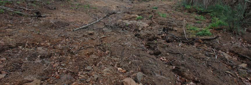
21 Armea test site In 2000, intense rainstorm triggered hundreds of shallow rapid landslides July 2007 Belgirate, Italy 21
22 Meteo-hydrological modelling Service 2 data flow and processing WebGIS CIMA TPZ FTP UNIFI Mapserver Slope stability modelling July 2007 Belgirate, Italy 22
23 Performed by CIMA (Centro Interuniversitario di Monitoraggio Ambientale Univ. Genova): Meteo-hydrological modelling Ground-based radar provides the precipitation field at a scale of a few km in space and tens of minutes in time Nowcasting of rainfall provides maps indicating the exceedance probability of given precipitation intensity-duration thresholds for the following hours July 2007 Belgirate, Italy 23
: 1x1 km 1 hr 19-20 July 2007 Belgirate,")
24 Meteo-hydrological modelling RADAR SCAN RESOLUTION: 1x1 km 10 min RADAR PRODUCT RESOLUTION (cumulated rainfall corrected on the basis of rain-gauge measurements): 1x1 km 1 hr July 2007 Belgirate, Italy 24

25 Meteo-hydrological modelling Radar rainfall July 2007 Belgirate, Italy 25

26 Meteo-hydrological modelling Radar rainfall corrected with rain gauges July 2007 Belgirate, Italy 26
27 Used as a monitoring tool Meteo-hydrological modelling Rainfall nowcasting Similar basis as the downscaling model Langevin eq (simplified convection-diffusion equation) is integrated forward randomizing the phases in the frequency domain An ensemble of nowcasts is provided together with the probability of exceedence of fixed rainfall thresholds The lead time spans from 30-min to 2 hrs (quite optimistic) July 2007 Belgirate, Italy 27
28 Meteo-hydrological modelling Rainfall nowcasting Radar history Nowcast members at T0+2 hrs July 2007 Belgirate, Italy 28

29 Meteo-hydrological modelling Soil saturation July 2007 Belgirate, Italy 29

30 Meteo-hydrological modelling Soil saturation maps July 2007 Belgirate, Italy 30
31 Slope stability other input data DEM Distributed geotechnical parameters (angle of internal friction, cohesion) Distributed soil thickness July 2007 Belgirate, Italy 31
 Slope stability Fieldwork 19-20 July 2007 Belgirate,")
32 Measure soil depth Measure soil permeability Collect soil samples for lab tests (geotechnical parameters) Slope stability Fieldwork July 2007 Belgirate, Italy 32
33 Slope stability Soil depth modelling In the infinite slope model the factor of safety is very sensitive to soil depth Soil depth is difficult to determine accurately at basin scale Simplified models for estimating soil depth generally produce poor results July 2007 Belgirate, Italy 33
34 Slope stability Soil depth modelling Common basin-scale soil depth models: Constant thickness Proportional to elevation Proportional to slope July 2007 Belgirate, Italy 34
35 We propose a model that takes into account: Slope stability Soil depth modelling Topography Mean abs. Model error (cm) Slope angle Slope curvature Elevation 78 Geology Soil catena Slope 103 GIST July 2007 Belgirate, Italy

 c / γz + r u sin β")

36 Slope Stability computation Soil saturation FS = ( 2 cos β ) c / γz + r u sin β cos β tanφ Soil thickness Soil parameters GIS Distributed FS


37 19-20 July 2007 Belgirate, Italy Slope stability Results


38 Slope stability validation Compare FS results to actual event The 2000 event in Armea basin was extensively mapped and studied but Radar rainfall data was not yet available! Need new event July 2007 Belgirate, Italy


39 Slope stability validation 18 December 2006 New event! July 2007 Belgirate, Italy
40 Couple infinite slope approach with infiltration model Introduce uncertainty: Service 2 Future development Use rainfall nowcasting to produce multiple FS maps and analyze statistically Use probability distribution of geotechnical parameters Addsecondtest site July 2007 Belgirate, Italy

41 Island of Ischia, Italy Service 2 Second test site


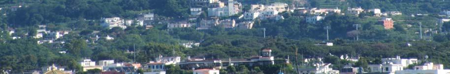

42 April 2006 Shallow landslides caused 4 deaths Service 2 Second test site

43 Where, after a hard day of work in the field The thermal baths of Ischia are waiting!
44 Contacts Thank you For more info: Nicola Casagli Gaia Righini Giacomo Falorni July 2007 Belgirate, Italy
45 Meteo-hydrological modelling NTT LAMI FORECAST 12 GMT 20 GMT 71 GMT 84 GMT NCT DOWNSCALED RAINFALL 12 GMT 20 GMT 30 GMT 39 GMT 63 GMT 72 GMT RADAR+GAUGES EVERY 3HRS C-DRiFt LANDSLIDES STABILITY MODEL 41 hrs LEAD TIME NOWCASTING 30 GMT31 GMT 72 GMT EVERY HR (lead-time 2 hrs) C-DRiFt 84 GMT 12 GMT 84 GMT Landslides Training Session 28 Feb - 1/2 March 2007 Firenze Italy
GMES EURORISK Geo-information services for natural and man-made risks management
 GMES EURORISK Geo-information services for natural and man-made risks management 8/11/2004 EURORISK A European scale approach for developing, delivering and operationally exploiting new information services
The Safeland Project General Overview and Monitoring Technology Development
 Ber. Geol. B. A., 82, ISSN 1017 8880 Landslide Monitoring Technologies & Early Warning Systems The Safeland Project General Overview and Monitoring Technology Development The SafeLand Consortium a), N.
Geophysical techniques for investigating shallow and deep landslides: results in the framework of PREVIEW project (FP6 UE)
") Geophysical techniques for investigating shallow and deep landslides: results in the framework of PREVIEW project (FP6 UE) Perrone, A; Piscitelli, S; Lampenna, V; Lamporte, A; Giocolli, A; Dahlin, Torleif
Geophysical techniques for investigating shallow and deep landslides: results in the framework of PREVIEW project (FP6 UE) Perrone, A; Piscitelli, S; Lampenna, V; Lamporte, A; Giocolli, A; Dahlin, Torleif
Europass Curriculum Vitae
 Europass Curriculum Vitae Personal information First name(s) / Surname(s) Francesco Silvestro Telephone(s) +39 019 861418 E-mail fdrancesco.silvestro@cimafoundation.org Nationality Italian Date of birth
Landslide Hazard Assessment Methodologies in Romania
 A Scientific Network for Earthquake, Landslide and Flood Hazard Prevention SciNet NatHazPrev Landslide Hazard Assessment Methodologies in Romania In the literature the terms of susceptibility and landslide
Objectives and hypotheses. Remote sensing: applications for landslide hazard assessment and risk management. Ping Lu (University of Firenze) Methods
 Methods") Topical Workshop Remote sensing: applications for landslide hazard assessment and risk management Ping Lu (University of Firenze) Supervisors: Prof. Nicola Casagli; Prof. Filippo Catani (Unifi) Dr. Veronica
Topical Workshop Remote sensing: applications for landslide hazard assessment and risk management Ping Lu (University of Firenze) Supervisors: Prof. Nicola Casagli; Prof. Filippo Catani (Unifi) Dr. Veronica
INCA CE: Integrating Nowcasting with crisis management and risk prevention in a transnational framework
 INCA CE: Integrating Nowcasting with crisis management and risk prevention in a transnational framework Yong Wang ZAMG, Austria This project is implemented through the CENTRAL EUROPE Programme co-financed
DETECTION AND FORECASTING - THE CZECH EXPERIENCE
 1 STORM RAINFALL DETECTION AND FORECASTING - THE CZECH EXPERIENCE J. Danhelka * Czech Hydrometeorological Institute, Prague, Czech Republic Abstract Contribution presents the state of the art of operational
Innovative Ways to Monitor Land Displacement
 ARTICLE Innovative Ways to Monitor Land Displacement When people think about landslides, they usually imagine large mud streams which cause considerable loss of life. Whereas such large-scale disasters
FLORA: FLood estimation and forecast in complex Orographic areas for Risk mitigation in the Alpine space
 Natural Risk Management in a changing climate: Experiences in Adaptation Strategies from some European Projekts Milano - December 14 th, 2011 FLORA: FLood estimation and forecast in complex Orographic
WMO/WWRP FDP: INCA CE
 WMO/WWRP FDP: INCA CE Yong Wang ZAMG, Austria This project is implemented through the CENTRAL EUROPE Programme co-financed by the ERDF INCA CE: implementation over Central Europe A Nowcasting Initiative
Haiti and Dominican Republic Flash Flood Initial Planning Meeting
 Dr Rochelle Graham Climate Scientist Haiti and Dominican Republic Flash Flood Initial Planning Meeting September 7 th to 9 th, 2016 Hydrologic Research Center http://www.hrcwater.org Haiti and Dominican
IPL Project (IPL - 196) Annual Report Form 2017
 Annual Report Form 2017") Date of Submission 26/03/2017 IPL Project (IPL - 196) Annual Report Form 2017 1 January 2016 to 31 December 2016 1. Project Number (approved year) and Title, IPL-196 (2015) Development and applications
Date of Submission 26/03/2017 IPL Project (IPL - 196) Annual Report Form 2017 1 January 2016 to 31 December 2016 1. Project Number (approved year) and Title, IPL-196 (2015) Development and applications
Global Monitoring for Environment and Security (GMES)
") Global Monitoring for Environment and Security (GMES) Satellite Earth Observation for the Emergency Services Dr Nick Veck Presentation to the G-STEP Launch Univ. of Leicester 19 th June 2009 Contents of
Global Monitoring for Environment and Security (GMES) Satellite Earth Observation for the Emergency Services Dr Nick Veck Presentation to the G-STEP Launch Univ. of Leicester 19 th June 2009 Contents of
Caribbean Early Warning System Workshop
 Caribbean Early Warning System Workshop Hamonization in Existing EWS April 14-16, 2016 Presenter: Shawn Boyce Caribbean Institute for Meteorology and Hydrology Husbands, St. James Barbados Background Between
Progress Report Form of WCoEs 2014
 Date of Submission 25/02/2015 Progress Report Form of WCoEs 2014 3 June 2014 to 31 December 2014 1. Short Title of WCoE: Advanced Technologies for LandSlides (ATLaS) 2. Name of Institution (Name of leader
Global Flash Flood Guidance System Status and Outlook
 Global Flash Flood Guidance System Status and Outlook HYDROLOGIC RESEARCH CENTER San Diego, CA 92130 http://www.hrcwater.org Initial Planning Meeting on the WMO HydroSOS, Entebbe, Uganda 26-28 September
Regional Flash Flood Guidance and Early Warning System
 WMO Training for Trainers Workshop on Integrated approach to flash flood and flood risk management 24-28 October 2010 Kathmandu, Nepal Regional Flash Flood Guidance and Early Warning System Dr. W. E. Grabs
Climate change and natural disasters, Athens, Greece October 31, 2018
 Flood early warning systems: operational approaches and challenges Climate change and natural disasters, Athens, Greece October 31, 2018 Athens, October 31, 2018 Marco Borga University of Padova, Italy
Two case history of EMS data application: earthquake in central italy and flooding in Piedmont region
 Two case history of EMS data application: earthquake in central italy and flooding in Piedmont region Luca Lanteri*, Rocco Pispico*, R. Cremonini** *Arpa Piemonte, Geological and Natural Risk Dipartiment
Progress Report. Flood Hazard Mapping in Thailand
 Progress Report Flood Hazard Mapping in Thailand Prepared By: Mr. PAITOON NAKTAE Chief of Safety Standard sub-beuro Disaster Prevention beuro Department of Disaster Prevention and Mitigation THAILAND E-mail:
Ingo Meirold-Mautner Yong Wang Alexander Kann Benedikt Bica Georg Pistotnik
 INCA-CE: The challenge of severe weather warnings Ingo Meirold-Mautner Yong Wang Alexander Kann Benedikt Bica Georg Pistotnik INCA Central Europe Integrated nowcasting for the Central European area BALTRAD
Aurora Bell*, Alan Seed, Ross Bunn, Bureau of Meteorology, Melbourne, Australia
 15B.1 RADAR RAINFALL ESTIMATES AND NOWCASTS: THE CHALLENGING ROAD FROM RESEARCH TO WARNINGS Aurora Bell*, Alan Seed, Ross Bunn, Bureau of Meteorology, Melbourne, Australia 1. Introduction Warnings are
Flash Flood Guidance System On-going Enhancements
 Flash Flood Guidance System On-going Enhancements Hydrologic Research Center, USA Technical Developer SAOFFG Steering Committee Meeting 1 10-12 July 2017 Jakarta, INDONESIA Theresa M. Modrick Hansen, PhD
National Public Weather and Warning Services in the Swaziland Meteorological Service Dennis S.Mkhonta /
 National Public Weather and Warning Services in the Swaziland Meteorological Service Dennis S.Mkhonta dennis.mkhonta@gmail.com / dennis@swazimet.gov.sz Introduction Swaziland s geographical position exposes
Challenges in providing effective flood forecasts and warnings
 Challenges in providing effective flood forecasts and warnings National Centre for Flood Research Inaugural Symposium Justin Robinson Bureau of Meteorology October 2018 Zero Lives Lost A key responsibility
Terrafirma monitoring and mapping landslide services for Europe based on InSAR satellite data
 Department of Earth Sciences CENTRE OF COMPETENCE OF THE CIVIL PROTECTION DEPARTMENT PRESIDENCY OF THE COUNCIL OF MINISTERS Terrafirma monitoring and mapping landslide services for Europe based on InSAR
Outline. Research Achievements
 Taiwan Typhoon and Flood Research Institute, National Applied Research Laboratories 11F., No.97, Sec. 1, Roosevelt Rd., Zhongzheng Dist., Taipei City 10093, Taiwan (R.O.C.) http://www.ttfri.narl.org.tw/eng/index.html
United States Multi-Hazard Early Warning System
 United States Multi-Hazard Early Warning System Saving Lives Through Partnership Lynn Maximuk National Weather Service Director, Central Region Kansas City, Missouri America s s Weather Enterprise: Protecting
INCA-CE achievements and status
 INCA-CE achievements and status Franziska Strauss Yong Wang Alexander Kann Benedikt Bica Ingo Meirold-Mautner INCA Central Europe Integrated nowcasting for the Central European area This project is implemented
CONTRIBUTION OF ENSEMBLE FORECASTING APPROACHES TO FLASH FLOOD NOWCASTING AT GAUGED AND UNGAUGED CATCHMENTS
 CONTRIBUTION OF ENSEMBLE FORECASTING APPROACHES TO FLASH FLOOD NOWCASTING AT GAUGED AND UNGAUGED CATCHMENTS Maria-Helena Ramos 1, Julie Demargne 2, Pierre Javelle 3 1. Irstea Antony, 2. Hydris Hydrologie,
Smart use of Geographic Information System (GIS) platform for delivering weather information and nowcasting services
 platform for delivering weather information and nowcasting services") Smart use of Geographic Information System (GIS) platform for delivering weather information and nowcasting services C. K. Pan Hong Kong Observatory Hong Kong, China It is a world of beauty Source: Image
Smart use of Geographic Information System (GIS) platform for delivering weather information and nowcasting services C. K. Pan Hong Kong Observatory Hong Kong, China It is a world of beauty Source: Image
Workshop on hydrological modelling, forecasting and warnings
 WMO RAVI Hydrological Forum 2016 Workshop on hydrological modelling, forecasting and warnings 20 September 2016, Oslo, Norway Norwegian Water Resources and Energy Directorate (NVE) Middelthunsgate 29,
Forecasting Flood Risk at the Flood Forecasting Centre, UK. Delft-FEWS User Days David Price
 Forecasting Flood Risk at the Flood Forecasting Centre, UK Delft-FEWS User Days 2012 David Price Overview of the Flood Forecasting Centre (FFC) What is the FFC? Partnership between the Met Office and Environment
Operational Hydrologic Ensemble Forecasting. Rob Hartman Hydrologist in Charge NWS / California-Nevada River Forecast Center
 Operational Hydrologic Ensemble Forecasting Rob Hartman Hydrologist in Charge NWS / California-Nevada River Forecast Center Mission of NWS Hydrologic Services Program Provide river and flood forecasts
Understanding Weather and Climate Risk. Matthew Perry Sharing an Uncertain World Conference The Geological Society, 13 July 2017
 Understanding Weather and Climate Risk Matthew Perry Sharing an Uncertain World Conference The Geological Society, 13 July 2017 What is risk in a weather and climate context? Hazard: something with the
Emergency Management Service (EMS) mapping
 mapping") GMES Emergency Management Service (EMS) mapping Frédéric BASTIDE GMES unit, European Commission UN-SPIDER Expert Meeting: "Crowdsource Mapping for Disaster Risk Management and Emergency Response" 3-5 December,
GMES Emergency Management Service (EMS) mapping Frédéric BASTIDE GMES unit, European Commission UN-SPIDER Expert Meeting: "Crowdsource Mapping for Disaster Risk Management and Emergency Response" 3-5 December,
On the use of radar rainfall estimates and nowcasts in an operational heavy rainfall warning service
 On the use of radar rainfall estimates and nowcasts in an operational heavy rainfall warning service Alan Seed, Ross Bunn, Aurora Bell Bureau of Meteorology Australia The Centre for Australian Weather
EARLY WARNING SYSTEM AND THE ROLE OF METEOROLOGICAL AND HYDROLOGICAL SERVICE CROATIA
 EARLY WARNING SYSTEM AND THE ROLE OF METEOROLOGICAL AND HYDROLOGICAL SERVICE CROATIA Meteorological and Hydrological Service National Protection and Rescue Directorate B. Ivančan an-picek V. Stajčić Establishment
Emerging Needs, Challenges and Response Strategy
 Emerging Needs, Challenges and Response Strategy Development of Integrated Observing Systems in China JIAO Meiyan Deputy Administrator China Meteorological Administration September 2011 Geneva Outline
Progress Report: Sentinel Asia Success Story in the Philippines
 Progress Report: Sentinel Asia Success Story in the Philippines 3 rd Joint Project Team Meeting on the Sentinel Asia STEP-2 July 6-8, 2010 Hyatt Hotel, Manila, Philippines Renato U. Solidum Jr. Director
INCA-CE: The Challenge of Severe Weather Warnings. Yong Wang, ZAMG
 INCA-CE: The Challenge of Severe Weather Warnings Yong Wang, ZAMG Severe Weather and Impact The need of civil society and economy Save Life! Save Cost! Reduce Risks and impacts! The Challenge of Severe
Welcome LESSLOSS Workshop
 Welcome LESSLOSS Workshop Alois J. Sieber acting Director Belgirate 19 July 2007 Page 1 JRC s Mission to provide customer-driven scientific and technical support for the conception, development, implementation
Operational Perspectives on Hydrologic Model Data Assimilation
 Operational Perspectives on Hydrologic Model Data Assimilation Rob Hartman Hydrologist in Charge NOAA / National Weather Service California-Nevada River Forecast Center Sacramento, CA USA Outline Operational
Integrating Nowcastingwith crisis management and risk prevention in a transnational framework (INCA-CE)
") Integrating Nowcastingwith crisis management and risk prevention in a transnational framework (INCA-CE) Yong Wang ZAMG, Austria This project is implemented through the CENTRAL EUROPE Programme co-financed
Integrating Nowcastingwith crisis management and risk prevention in a transnational framework (INCA-CE) Yong Wang ZAMG, Austria This project is implemented through the CENTRAL EUROPE Programme co-financed
The regional early warning system for rainfall-induced landslides operating in Campania (Italy): performance evaluation of two warning strategies
: performance evaluation of two warning strategies") 1st IMEKO TC-4 International Workshop on Metrology for geotechnics 17-18 March 2016, Benevento (Italy) The regional early warning system for rainfall-induced landslides operating in Campania (Italy): performance
1st IMEKO TC-4 International Workshop on Metrology for geotechnics 17-18 March 2016, Benevento (Italy) The regional early warning system for rainfall-induced landslides operating in Campania (Italy): performance
Application and verification of ECMWF products 2016
 Application and verification of ECMWF products 2016 Icelandic Meteorological Office (www.vedur.is) Bolli Pálmason and Guðrún Nína Petersen 1. Summary of major highlights Medium range weather forecasts
Progress Report Form of WCoEs 2012
 ANNEX 4 Date of Submission Progress Report Form of WCoEs 2012 1. Short Title of WCoE: Advanced Technologies for LandSlides (ATLaS) 2. Name of Institution (Name of leader and email): Department of Earth
EARLY WARNING IN SOUTHERN AFRICA:
 EARLY WARNING IN SOUTHERN AFRICA: Enhancing the Meteorological Early Warning System Eugene Poolman South African Weather Service OUTLINE OF PRESENTATION Impact of Climate Change Meteorological Early Warning
Copernicus Overview and Emergency Management Service
 Copernicus Overview and Emergency Management Service Frédéric BASTIDE European Commission Open informal session of the United Nations Inter-Agency Meeting on Outer Space Activities 12 March 2013, Geneva
Overview of Early Warning Systems and the role of National Meteorological and Hydrological Services
 Overview of Early Warning Systems and the role of National Meteorological and Hydrological Services South Africa Second Experts Symposium on Multi-Hazard Early Warning Systems With focus on the Role of
Estimation of landslides activities evolution due to land use changes in a Pyrenean valley
 Estimation of landslides activities evolution due to land use changes in a Pyrenean valley R. Vandromme, N. Desramaut, S. Bernardie, G. Grandjean 1 Introduction (1) > Need to produce dynamic susceptibility
Workshop on Drought and Extreme Temperatures: Preparedness and Management for Sustainable Agriculture, Forestry and Fishery
 Workshop on Drought and Extreme Temperatures: Preparedness and Management for Sustainable Agriculture, Forestry and Fishery 16-17 Feb.2009, Beijing, China Modeling Apple Tree Bud burst time and frost risk
Statistical Seismic Landslide Hazard Analysis: an Example from Taiwan
 Statistical Seismic Landslide Hazard Analysis: an Example from Taiwan Chyi-Tyi Lee Graduate Institute of Applied Geology, National Central University, Taiwan Seismology Forum 27: Natural Hazards and Surface
The importance of satellite data and products for RA1 in the WWRP strategy. Estelle de Coning World Weather Research Division
 The importance of satellite data and products for RA1 in the WWRP strategy Estelle de Coning World Weather Research Division Kofi Annan former UN Secretary-General (21 July 2016) "The poor need alerts
Practical reliability approach to urban slope stability
 University of Wollongong Research Online Faculty of Engineering - Papers (Archive) Faculty of Engineering and Information Sciences 2011 Practical reliability approach to urban slope stability R. Chowdhury
I&CLC2000 in support to new policy initiatives (INSPIRE, GMES,..)
") I&CLC2000 in support to new policy initiatives (INSPIRE, GMES,..) Manfred Grasserbauer, Director Joint Research Centre Institute for Environment and Sustainability 1 IMAGE 2000 European mosaic of satellite
I&CLC2000 in support to new policy initiatives (INSPIRE, GMES,..) Manfred Grasserbauer, Director Joint Research Centre Institute for Environment and Sustainability 1 IMAGE 2000 European mosaic of satellite
12/07/2017. Flash Flood Warning Service, an advanced approach towards flood resilient cities Floodplain Management Association Conference, Newcastle
 12/07/2017 Worldwide problem: Flash Floods Flash Floods are a Global Problem Flash Flood Warning Service, an advanced approach towards flood resilient cities Floodplain Management Association Conference,
Landslide risk. Prof. Nicola Casagli Director of ICL European Centre, University of Florence (Italy)
") Consortium on Landslides Landslide risk Prof. Nicola Casagli Director of ICL European Centre, University of Florence (Italy) Preparatory Workshop on Science and Technology for the Global Platform for Disaster
Consortium on Landslides Landslide risk Prof. Nicola Casagli Director of ICL European Centre, University of Florence (Italy) Preparatory Workshop on Science and Technology for the Global Platform for Disaster
Terranum Sàrl. Rock-solid Expertise and Software
 Terranum Sàrl Rock-solid Expertise and Software About Founded in May 2011, Terranum Sàrl develops rock-solid expertise for natural hazards, geology, hydrology, 3D and LiDAR measurements, and customized
GIS in Weather and Society
 GIS in Weather and Society Olga Wilhelmi Institute for the Study of Society and Environment National Center for Atmospheric Research WAS*IS November 8, 2005 Boulder, Colorado Presentation Outline GIS basic
Effective Utilization of Synthetic Aperture Radar (SAR) Imagery in Rapid Damage Assessment
 Imagery in Rapid Damage Assessment") Effective Utilization of Synthetic Aperture Radar (SAR) Imagery in Rapid Damage Assessment Case Study Pakistan Floods SUPARCO M. Maisam Raza, Ahmad H. Rabbani SEQUENCE Flood Monitoring using Satellite
Effective Utilization of Synthetic Aperture Radar (SAR) Imagery in Rapid Damage Assessment Case Study Pakistan Floods SUPARCO M. Maisam Raza, Ahmad H. Rabbani SEQUENCE Flood Monitoring using Satellite
GEO The Åknes rock slope. Content. Dr. Vidar Kveldsvik NGI
 GEO 4180 The Åknes rock slope Dr. Vidar Kveldsvik NGI Content Background on large rock slides Triggers Stability analysis Risk mitigation (risk reduction) The Åknes rock slope 1 Background Landslides due
World Meteorological Organization
 World Meteorological Organization Opportunities and Challenges for Development of Weather-based Insurance and Derivatives Markets in Developing Countries By Maryam Golnaraghi, Ph.D. Head of WMO Disaster
LECTURE #11: Volcanoes: Monitoring & Mitigation
 GEOL 0820 Ramsey Natural Disasters Spring, 2018 LECTURE #11: Volcanoes: Monitoring & Mitigation Date: 15 February 2018 I. What is volcanic monitoring? the continuous collection of one or more data sources
Visualising and communicating probabilistic flow forecasts in The Netherlands
 Visualising and communicating probabilistic flow forecasts in The Netherlands Eric Sprokkereef Centre for Water Management Division Crisis Management & Information Supply 2-2-2009 Content The basins Forecasting
Copernicus Overview. Major Emergency Management Conference Athlone 2017
 Copernicus Overview Major Emergency Management Conference Athlone 2017 Copernicus is a European programme implemented by the European Commission. The services address six thematic areas: land, marine,
LATE REQUEST FOR A SPECIAL PROJECT
 LATE REQUEST FOR A SPECIAL PROJECT 2016 2018 MEMBER STATE: Italy Principal Investigator 1 : Affiliation: Address: E-mail: Other researchers: Project Title: Valerio Capecchi LaMMA Consortium - Environmental
Seamless Probabilistic Forecasts for Civil Protection: from week to minutes
 Seamless Probabilistic Forecasts for Civil Protection: from week to minutes Yong Wang, Clemens Wastl, Andre Simon, Mihaly Szűcs ZAMG and HMS An EU project Bridging of Probabilistic Forecasts and Civil
Global Flood Awareness System GloFAS
 Global Flood Awareness System GloFAS Ervin Zsoter with the help of the whole EFAS/GloFAS team Ervin.Zsoter@ecmwf.int 1 Reading, 8-9 May 2018 What is GloFAS? Global-scale ensemble-based flood forecasting
Fukien Secondary School Monthly Vocabulary/Expression List for EMI Subjects Secondary Two. Subject: Geography
 Focus: General Specific : Section Two : Unit One 1 Landslide 2 Downslope movement 3 Rock 4 Soil 5 Gravity 6 Natural hazard 7 Rainwater 8 Friction 9 Hilly relief 10 Unstable 11 Season 12 Saturated 13 Construction
Landslide Forecasting and Warning Mechanism
 Annual Conference of Relief Commissioners, Disaster Management 18 May 2018, Vigyan Bhawan, New Delhi Landslide Forecasting and Warning Mechanism Dr. Saibal Ghosh Director, GSI, New Delhi Understanding
Simulation of heavy precipitation events with the COSMO model
 LM User Seminar, 6 March 2007, Langen Federal Department of Home Affairs FDHA Federal Office of Meteorology and Climatology MeteoSwiss Simulation of heavy precipitation events with the COSMO model Silke
H SAF SATELLITE APPLICATION FACILITY ON SUPPORT TO OPERATIONAL HYDROLOGY AND WATER MANAGEMENT EUMETSAT NETWORK OF SATELLITE APPLICATION FACILITIES
 H SAF SATELLITE APPLICATION FACILITY ON SUPPORT TO OPERATIONAL HYDROLOGY AND WATER MANAGEMENT EUMETSAT NETWORK OF SATELLITE APPLICATION FACILITIES H-SAF: SATELLITE PRODUCTS FOR OPERATIONAL HYDROLOGY H-SAF
Roles of NGII in successful disaster management
 The Second UN-GGIM-AP Plenary Meeting Roles of NGII in successful disaster management Republic of Korea Teheran Iran 28 October 2013 Sanghoon Lee, Ph.D. NGII Outline Type of Disasters Occur in Korea Practical
EO Information Services. Assessing Vulnerability in the metropolitan area of Rio de Janeiro (Floods & Landslides) Project
 Project") EO Information Services in support of Assessing Vulnerability in the metropolitan area of Rio de Janeiro (Floods & Landslides) Project Ricardo Armas, Critical Software SA Haris Kontoes, ISARS NOA World
EO Information Services in support of Assessing Vulnerability in the metropolitan area of Rio de Janeiro (Floods & Landslides) Project Ricardo Armas, Critical Software SA Haris Kontoes, ISARS NOA World
THE ADRIARadNet PROJECT
 THE ADRIARadNet PROJECT Activity carried out by Abruzzo Region: Results, problems, aims A. Santacasa, G. Ragni, L. Tontodimamma, F. Rossi, A. Cimoroni, B. Di Giacomantonio, A. Iovino The main project activities
REQUIREMENTS FOR WEATHER RADAR DATA. Review of the current and likely future hydrological requirements for Weather Radar data
 WORLD METEOROLOGICAL ORGANIZATION COMMISSION FOR BASIC SYSTEMS OPEN PROGRAMME AREA GROUP ON INTEGRATED OBSERVING SYSTEMS WORKSHOP ON RADAR DATA EXCHANGE EXETER, UK, 24-26 APRIL 2013 CBS/OPAG-IOS/WxR_EXCHANGE/2.3
Improvement of Hazard Assessment and Management in the Philippines
 Improvement of Hazard Assessment and Management in the Philippines (2014 Summer Training Course for Slope Land Disaster Reduction) Ian Alejandrino (Philippines) Nguyen Manh Hieu (Vietnam) Presentation
Assessing Hazards and Risk
 Page 1 of 6 EENS 204 Tulane University Natural Disasters Prof. Stephen A. Nelson Assessing Hazards and Risk This page last updated on 07-Jan-2004 As discussed before, natural disasters are produced by
COUNTRY REPORT INDONESIA
 COUNTRY REPORT INDONESIA Badan Meteorologi Klimatologi dan Geofisika (BMKG) Agency For Meteorology, Climatology, and Geophysics Republic of Indonesia DKI Jakarta, Indonesia Tel. (021) 4246321 Email: pcs@bmkg.go.id
C o p e r n i c u s E m e r g e n c y M a n a g e m e n t S e r v i c e f o r e c a s t i n g f l o o d s
 C o p e r n i c u s E m e r g e n c y M a n a g e m e n t S e r v i c e f o r e c a s t i n g f l o o d s Copernicus & Copernicus Services Copernicus EU Copernicus EU Copernicus EU www.copernicus.eu W
RISK ASSESSMENT COMMUNITY PROFILE NATURAL HAZARDS COMMUNITY RISK PROFILES. Page 13 of 524
 RISK ASSESSMENT COMMUNITY PROFILE NATURAL HAZARDS COMMUNITY RISK PROFILES Page 13 of 524 Introduction The Risk Assessment identifies and characterizes Tillamook County s natural hazards and describes how
Surface Hydrology Research Group Università degli Studi di Cagliari
 Surface Hydrology Research Group Università degli Studi di Cagliari Evaluation of Input Uncertainty in Nested Flood Forecasts: Coupling a Multifractal Precipitation Downscaling Model and a Fully-Distributed
Civil protection. (public, government and local authorities institutions)
") 23 Civil protection (public, government and local authorities institutions) Overview Statistics from the Centre for Research on the Epidemiology of Disasters (CRED) at the University of Leuven, Belgium,
23 Civil protection (public, government and local authorities institutions) Overview Statistics from the Centre for Research on the Epidemiology of Disasters (CRED) at the University of Leuven, Belgium,
DIPLOMA IN DISASTER MANAGEMENT. (Non-Semester) (With effect from the academic year )
 (With effect from the academic year )") DIPLOMA IN DISASTER MANAGEMENT (Non-Semester) (With effect from the academic year 2013-14) Eligibility for the Course Candidate should have passed the Higher Secondary Examination conducted by the Board
DIPLOMA IN DISASTER MANAGEMENT (Non-Semester) (With effect from the academic year 2013-14) Eligibility for the Course Candidate should have passed the Higher Secondary Examination conducted by the Board
MODELLING FROST RISK IN APPLE TREE, IRAN. Mohammad Rahimi
 WMO Regional Seminar on strategic Capacity Development of National Meteorological and Hydrological Services in RA II (Opportunity and Challenges in 21th century) Tashkent, Uzbekistan, 3-4 December 2008
Use of satellite information in research and operational activities at NIMH of Bulgaria
 Use of satellite information in research and operational activities at NIMH of Bulgaria Rilka Valcheva NIMH, Bulgaria WMO/EUMETSAT Satellite Products Training Course 24-28 April 2017, Budapest, Hungary
They include earthquakes, volcanic eruptions, floods, landslides, and other processes and occurrences. They are included in the broader concept of.
 They include earthquakes, volcanic eruptions, floods, landslides, and other processes and occurrences. They are included in the broader concept of. In general, natural processes are labeled hazardous only
8 Current Issues and Research on Sediment Movement in the River Catchments of Japan
 8 Current Issues and Research on Sediment Movement in the River Catchments of Japan YUTAKA ICHIKAWA INTRODUCTION Prediction of sediment movement is one of the challenging tasks in water-related research.
Folsom Dam Water Control Manual Update
 Folsom Dam Water Control Manual Update Public Workshop April 3, 2014 Location: Sterling Hotel Ballroom 1300 H Street, Sacramento US Army Corps of Engineers BUILDING STRONG WELCOME & INTRODUCTIONS 2 BUILDING
FOREST FIRE HAZARD MODEL DEFINITION FOR LOCAL LAND USE (TUSCANY REGION)
") FOREST FIRE HAZARD MODEL DEFINITION FOR LOCAL LAND USE (TUSCANY REGION) C. Conese 3, L. Bonora 1, M. Romani 1, E. Checcacci 1 and E. Tesi 2 1 National Research Council - Institute of Biometeorology (CNR-
FOREST FIRE HAZARD MODEL DEFINITION FOR LOCAL LAND USE (TUSCANY REGION) C. Conese 3, L. Bonora 1, M. Romani 1, E. Checcacci 1 and E. Tesi 2 1 National Research Council - Institute of Biometeorology (CNR-
DEVELOPMENT OF A FORECAST EARLY WARNING SYSTEM ethekwini Municipality, Durban, RSA. Clint Chrystal, Natasha Ramdass, Mlondi Hlongwae
 DEVELOPMENT OF A FORECAST EARLY WARNING SYSTEM ethekwini Municipality, Durban, RSA Clint Chrystal, Natasha Ramdass, Mlondi Hlongwae LOCATION DETAILS AND BOUNDARIES ethekwini Municipal Area = 2297 km 2
"Outcomes of the storm surge and waves workshop in Dominican Republic and the questionnaire"
 "Outcomes of the storm surge and waves workshop in Dominican Republic and the questionnaire" Strengthening Regional Cooperation to Support Forecasting with Multi Hazard Approach in RA IV Ritz Carlton Grand
FFGS Concept HYDROLOGIC RESEARCH CENTER. 2 May 2017
 FFGS Concept HYDROLOGIC RESEARCH CENTER 2 May 2017 Research and Development History 1970-1988: US NWS Produces FFG statistically for each River Forecast Center. Also, research in adaptive site specific
Crisis Management and Natural Disasters Overview of JRC operational or pre-operational activities A. Annunziato, D. Al-Khudhairy
 Papagayo, Costarica 3-4 November 2009 Security Science and The Americas 1 Joint Research Centre (JRC) Crisis Management and Natural Disasters Overview of JRC operational or pre-operational activities A.
CASA WX DFW URBAN DEMONSTRATION NETWORK
 CASA WX DFW URBAN DEMONSTRATION NETWORK Goals Background on Regional CASA WX Project Explain the capabilities, structure of the Radar Network Present the CASA WX DFW Test Bed will be rolled out Describe
A METHODOLOGY FOR ASSESSING EARTHQUAKE-INDUCED LANDSLIDE RISK. Agency for the Environmental Protection, ITALY (
 A METHODOLOGY FOR ASSESSING EARTHQUAKE-INDUCED LANDSLIDE RISK Roberto W. Romeo 1, Randall W. Jibson 2 & Antonio Pugliese 3 1 University of Urbino, ITALY (e-mail: rwromeo@uniurb.it) 2 U.S. Geological Survey
Evaluation of Landslide Hazard Assessment Models at Regional Scale (SciNet NatHazPrev Project)
") Evaluation of Landslide Hazard Assessment Models at Regional Scale (SciNet NatHazPrev Project) Democritus University of Thrace (P1) Department of Civil Engineering Geotechnical Division Scientific Staff:
Evaluation of Landslide Hazard Assessment Models at Regional Scale (SciNet NatHazPrev Project) Democritus University of Thrace (P1) Department of Civil Engineering Geotechnical Division Scientific Staff:
International Symposium on Natural Disaster Mitigation. Local vulnerability assessment of landslides and debris flows
 International Symposium on Natural Disaster Mitigation of landslides and debris flows Lessons learnt from Cam Pha town and Van Don district, Quang Ninh province, Vietnam Nguyen Quoc Phi Faculty of Environment