Landslide Hazard Assessment Methodologies in Romania
|
|
|
- Melvin Francis
- 6 years ago
- Views:
Transcription
1 A Scientific Network for Earthquake, Landslide and Flood Hazard Prevention SciNet NatHazPrev Landslide Hazard Assessment Methodologies in Romania
2 In the literature the terms of susceptibility and landslide hazard are often used as synonyms, although they are different concepts (Guzzetti, 2005). Landslides susceptibility is the probability that a landslide to occur in an area characterized by certain environmental conditions (Brabb, 1984). Is the degree which a surface can be affected by the landslide process. In contrast, landslide hazard is the probability that a landslide of a given magnitude will occur in a given period of time and in a given area. In addition to prediction of where the landslide will occur, landslide hazard forecast "when" or "how frequently" it will produce and "how large" it will be (Guzzetti et al., 2005). Thus, susceptibility is the space component of landslide hazard.


3 Methods for landslide susceptibility evaluation Qualitative methods Quantitative methods - Geomorphological mapping; - Direct mapping method; - Multi-class weighting method; - Spatial multi-criteria analysis; - Analytical hierarchy process; - Fuzzy logic approach Bivariate methods: - Weights of evidence; - Certainty factors; - Dempster-Shafer method; - Fuzzy logic. Statistical methods Multivariate methods : - Discriminant analysis; - Logistic regression analysis; - Multiple regression analysis. Deterministic methods - Static infinite slope modeling; - Dynamic infinite slope modeling with rainfall trigger; - Earthquake induced infinite slope modeling.
4 In Romania, landslides are among the most widespread geomorphological processes in the hilly regions built of Neogene molasse deposits, as well as in the mountainous regions developed on Cretaceous and Paleogene flysch. During the 90s and early 2000s, in the estimation of landslide susceptibility was used especially qualitative approaches. The number of quantitative ones has risen steeply in the last years (Micu & Bălteanu, 2009; Armaș, 2011, 2012; Constantin et al., 2011; Șandric et al., 2011; Grozavu et al., 2012; Armaș et al., 2013).

5 Position of Study area Area = sq. kms. Faculty Romania s of Natural land and zoning Agricultural in terms Sciences of potential for erosion, - (Partner landslides no 4) / falls and floods
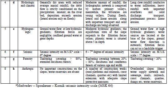
6 A series of normative acts published in several stages, such as: Law 575/2001, Law 124/1995, Government Decision 382 and 447/2003, Common Order of the Ministry of Public Works and Territorial Planning, of the Chief of Department for Local Public Administration and Ministry of Waters and Environmental Protection no. 62/N-19.0/ /1998, based on the Writing guide for landslides risk maps to ensure construction durability Indicative GT set the methodological norms regarding elaboration way and content of the landslides hazard maps based on calculating of the average coefficient of hazard K(m).
7 For drawing the map of landslide hazard are required the following steps: dividing the territory for which the hazard map is elaborated in bounded polygonal surfaces to represent as homogeneous lithologic and structural deposits ; estimating the weights and geographical distribution of risk coefficients K(a-h) depending on the criterion presented in Table 1; calculating the average hazard coefficient K(m) corresponding to each analyzed polygonal surface by using a specified formula (1); : determining the degree of potential (low, medium, high) associated with a certain probability of landslides occurrence (practically zero, low, medium, medium -high, high and very high ).

8 K ( m) K a 6 K b K c K d K e K f K g K h (1) Where: K a = lithologic criterion; K b = geomorphological criterion; K c = structural criterion; K d = hydrological and climatic criterion; K e = hydrogeological criterion; K f = seismic criterion; K g = forest cover criterion; K h = anthropogenous criterion, expressed through a scale from 0 to 1
 coefficient s value, are establish landslide occurrence Legend: potential: low potential, K(m) < 0.1 medium potential, K(m) = 0.1 to 0.3 medium-high potential, K(m) = 0.")
9 Among the landslide affecting factors, lithology and geomorphology are considered the most important. Depending on the K(m) coefficient s value, are establish landslide occurrence Legend: potential: low potential, K(m) < 0.1 medium potential, K(m) = 0.1 to 0.3 medium-high potential, K(m) = 0.3 to 0.5 high potential,, K(m) = 0.5 to 0.8 high-very high potential, K(m) are above 0.8.

10 Table 1. Rating -Criterion for landslide potential and probability occurrence assessment
11
12 Macro-zoning map of induced landslides risk in Romania

13 Map of landslides types - Romania
14 COMMENTS: In the absence of chronological information on the occurrence of landslides, spatial temporal probabilities cannot be calculated and consequently predictions must be restricted to the spatial distribution of future landslides; that is susceptibility (Bălteanu et al., 2010). There is no information regarding the differentiation between landslide types in the present methodology.
15 ADVANTAGES: gives an overview relatively suggestive of areas with different landslide potential; integrates data generally easier to find; can be used in case of lack information about the existence of landslides (obtained from inventory using different sources).
16 Hazard Risk Mitigation And Emergency Preparedness Project In Romania ( ) World Bank Project on natural disasters study in Romania, coordinated by RMSI (Risk Management Solutions India). Main goals: - execution of geological and geotechnical studies on two pilot areas for the design and implementation of an in situ monitoring system (including installation of monitoring equipment); - data collection and processing for elaboration of a model for landslides anticipation; - elaboration of a monitoring manual including elements of an early warning system; - design and implementation of a training program for local authorities.
17 More recent, Bălteanu et al., in 2010, have developed a landslide susceptibility model for the whole country applying a scoring system to a set of conditioning factors based on expert judgement (heuristic model). This research was carried out due to a World Bank project on losses and insurance costs relating to disasters in Romania, and aims to provide a unitary basis for addressing landslide susceptibility in the country. It takes into account the most important triggering factors, as well as settlements and infrastructure affected by landslides. It also forms the basis for elaboration of a landslide-hazard risk map in an attempt to quantify all potential losses related to this process.
18 Was used a Landslide Susceptibility Index (LSI) method based on quantitatively defined weighted values. Expert analysis, combined with a long history of landslide mapping and assessment and field experiments, play an important role in this method. The expert judgement involved a large number of studies and assessments undertaken at different scales, and geomorphological mapping of Romanian territory at the scale of 1:200,000. Triggering Factors In computing a GIS landslide-susceptibility map of Romania six major triggering factors were considered: lithology, height difference, slope angle, land use, rainfall seismicity. Each factor was classified under sub-classes carrying a rating from 0 to 10 according to its relevance for landslide susceptibility. Further, each factor was considered to have a differential influence on such susceptibility, named assigned weight.

19 The results were compared with different assessments from several countries. To validate the methodology, besides expert judgement, repeated geomorphic mapping over a long period, as well as field observations and measurements in the most affected regions, were used. Figure shows an example of a lithology rating map based on 1:200,000 scale map elaborated by the Institute of Geology, Romania.
, low, 10%, medium, 38.")
20 Susceptibility Classes The LSI was further classified under five hazard classes; each category based on correlation of expert judgement and existing geomorphological maps of the whole of Romania. The established classes are: no susceptibility, represents around 39% of Romania (plains and low hills), low, 10%, medium, 38.3%, high and very high susceptibility, classes around 10% (mostly in the Subcarpathian region).
 WP 103: Assets mapping")
21 IncREO - Increasing Resilience through Earth Observation (Jan. 13 Dec. 14). Project Structure WP 101: European/national legislation and existing GMES/Copernicus solutions WP 102: Three level assets mapping concept (national, regional, local) WP 103: Assets mapping specifications and production WP 201: Dam failure (Use case: Hungary) WP 202: Wind, waves and storm surges (Use cases: France and Bulgaria) WP 203: Flooding (Use case: Albania) WP 204: Landslide (Use case: Romania) WP 205: Multi-risk evaluation, hot spot identification and mapping (Use case: Italy) WP 206: Community networking and end-user facilitation WP 301: Geo-information atlas "Assets and natural hazards" WP 302: Global risk and vulnerability modelling and mapping WP 303: Multi-hazard atlas and risk analyser WP 402: Communication and dissemination WP 403: Scientific and technical coordination WP 401: Financial and contractual management of the consortium
22 IncREO project aims to: analyze legislation, existing strategies and prevention capabilities in priority regions (EU Floods Directive, the Danube Strategy); analysis of priority areas in terms of climate and hydrology using Earth observation satellite data; application of methods based on Earth Observation satellite data to study the impact of human intervention on the land use and land cover and increased incidence of natural disasters; defining and carrying out case studies for each type of hazard (earthquakes, landslides, fires, floods); recommendations on prioritizing of interventions in geographic regions prone to natural disasters. The objective of the work package which includes Romanian Space Agency ROSA, is to assess and map in a detailed manner the risk and vulnerability of areas in Romania highly prone to landslides in the Buzau County.


, geology, land use, max.")
23 The map shows the landslide susceptibility of Buzau County, Romania. For assessing the susceptibility of landslide prone areas a quantitative inventory-based probabilistic method with the approach of Weight of Evidence (WofE) was chosen. The following inputs were used: Landslide inventory (kindly provided by the FP7 CHANGES project), DEM (slope, aspect, relative relief), geology, land use, max. rainfall in 72 h, distance to drainage network. It is assumed that the landslide inventory is complete
24 CONCLUSIONS The methodology provided by the Ministry of Local Public Administration in 1998, 2001 and 2003 it is subjective and difficult to apply (Șandric et al., 2011), due to the uncertainties and different interpretations of the specialists that may occur in assigning weights to various landslide controlling factors in assessing susceptibility. Presently, there is no coherence and cohesion in decisions and actions taken by the research institutes and government institutions involved, at local or regional scale in systematic investigation, or a strategy for inventorying and monitoring of landslide affected areas, at national scale. Moreover, although a general trend of unification between the Romanian and the international terminology regarding landslide susceptibility, hazard and risk has been observed in recent years, the present methodological requirements underlying the legal framework are not updated.
Landslide Hazard Zonation Methods: A Critical Review
 International Journal of Civil Engineering Research. ISSN 2278-3652 Volume 5, Number 3 (2014), pp. 215-220 Research India Publications http://www.ripublication.com/ijcer.htm Landslide Hazard Zonation Methods:
A Framework for Web Integrated Information System for Risk Management of Natural Disasters
 2011 2nd International Conference on Education and Management Technology IPEDR vol.13 (2011) (2011) IACSIT Press, Singapore A Framework for Web Integrated Information System for Risk Management of Natural
Landslide Susceptibility Mapping Using Logistic Regression in Garut District, West Java, Indonesia
 Landslide Susceptibility Mapping Using Logistic Regression in Garut District, West Java, Indonesia N. Lakmal Deshapriya 1, Udhi Catur Nugroho 2, Sesa Wiguna 3, Manzul Hazarika 1, Lal Samarakoon 1 1 Geoinformatics
Landslide Susceptibility, Hazard, and Risk Assessment. Twin Hosea W. K. Advisor: Prof. C.T. Lee
 Landslide Susceptibility, Hazard, and Risk Assessment Twin Hosea W. K. Advisor: Prof. C.T. Lee Date: 2018/05/24 1 OUTLINE INTRODUCTION LANDSLIDE HAZARD ASSESSTMENT LOGISTIC REGRESSION IN LSA STUDY CASE
Disaster Risk Assessment: Opportunities for GIS and data management with Open DRI
 Disaster Risk Assessment: Opportunities for GIS and data management with Open DRI Jacob Opadeyi Department of Geomatics Engineering and Land Management, The University of the West Indies, St. Augustine,
SECTION II Hydrological risk
 Chapter 3 Understanding disaster risk: hazard related risk issues SECTION II Hydrological risk Peter Salamon Coordinating lead author Hannah Cloke Lead author 3.4 Giuliano di Baldassarre Owen Landeg Florian
Investigation of landslide based on high performance and cloud-enabled geocomputation
 Investigation of landslide based on high performance and cloud-enabled geocomputation Jun Liu 1, Shuguang Liu 2,*, Qiming Zhou 3, Jing Qian 1 1 Shenzhen Institutes of Advanced Technology, Chinese Academy
Debris flow: categories, characteristics, hazard assessment, mitigation measures. Hariklia D. SKILODIMOU, George D. BATHRELLOS
 Debris flow: categories, characteristics, hazard assessment, mitigation measures Hariklia D. SKILODIMOU, George D. BATHRELLOS Natural hazards: physical phenomena, active in geological time capable of producing
National Disaster Management Centre (NDMC) Republic of Maldives. Location
 Republic of Maldives. Location") National Disaster Management Centre (NDMC) Republic of Maldives Location Country Profile 1,190 islands. 198 Inhabited Islands. Total land area 300 sq km Islands range b/w 0.2 5 sq km Population approx.
National Disaster Management Centre (NDMC) Republic of Maldives Location Country Profile 1,190 islands. 198 Inhabited Islands. Total land area 300 sq km Islands range b/w 0.2 5 sq km Population approx.
STATUS OF HAZARD MAPS VULNERABILITY ASSESSMENTS AND DIGITAL MAPS
 JapanInternational Cooperation Agency STATUS OF HAZARD MAPS VULNERABILITY ASSESSMENTS AND DIGITAL MAPS ANGUILLA REPORT THE CARIBBEAN DISASTER EMERGENCY RESPONSE AGENCY () Table of Contents Page Preface
Buzau County: spatial planning vs. natural hazards September 2013 Perugia, Italy
 Buzau County: spatial planning vs. natural hazards 15-22 September 2013 Perugia, Italy National planning system: levels of administration NUTS 1: macroregions (not used yet) NUTS 2: development regions
Applying Hazard Maps to Urban Planning
 Applying Hazard Maps to Urban Planning September 10th, 2014 SAKAI Yuko Disaster Management Expert JICA Study Team for the Metro Cebu Roadmap Study on the Sustainable Urban Development 1 Contents 1. Outline
Questionnaire on Hazard Mapping
 Questionnaire on Hazard Mapping 1. General Questions 1.1. WHAT HAZARD MAPS HAVE BEEN DEVELOPED IN YOUR COUNTRY? The following refer to the work done by the Institute of Geology and Mineral Exploration
GEO Geohazards Community of Practice
 GEO Geohazards Community of Practice 1) Co-Chair of GHCP With input from: Stuart Marsh, GHCP Co-Chair Francesco Gaetani, GEO Secretariat and many GHCP contributors 1) Nevada Bureau of Mines and Geology
WMO/WWRP FDP: INCA CE
 WMO/WWRP FDP: INCA CE Yong Wang ZAMG, Austria This project is implemented through the CENTRAL EUROPE Programme co-financed by the ERDF INCA CE: implementation over Central Europe A Nowcasting Initiative
International Conference Analysis and Management of Changing Risks for Natural Hazards November 2014 l Padua, Italy
 Abstract Code: B01 Assets mapping products in support of preparedness and prevention measures (examples from Germany, Italy and France) Marc Mueller, Thierry Fourty, Mehdi Lefeuvre Airbus Defence and Space,
Increasing Resilience through Earth Observation- IncREO
 Increasing Resilience through Earth Observation- IncREO Numerical simulations and operational forecast of the hydro-meteorological hazards along the Bulgarian Black Sea coast. Results from the EU FP7 project
Hendra Pachri, Yasuhiro Mitani, Hiro Ikemi, and Ryunosuke Nakanishi
 21 2nd International Conference on Geological and Civil Engineering IPCBEE vol. 8 (21) (21) IACSIT Press, Singapore DOI: 1.7763/IPCBEE. 21. V8. 2 Relationships between Morphology Aspect and Slope Failure
Report. Developing a course component on disaster management
 Report Developing a course component on disaster management By Chira Prangkio Tawee Chaipimonplin Department of Geography, Faculty of Social Sciences, Chiang Mai University Thailand Presented at Indian
Oregon APA Legal Issues Workshop December 7, Tricia Sears, DLCD With information from Bill Burns, DOGAMI
 Oregon APA Legal Issues Workshop December 7, 2018 Tricia Sears, DLCD With information from Bill Burns, DOGAMI How this Topic Arrived WE FREQUENTLY HEAR CONCERNS ABOUT LIABILITY AND TAKINGS. Current federal
Georeferencing and Satellite Image Support: Lessons learned, Challenges and Opportunities
 Georeferencing and Satellite Image Support: Lessons learned, Challenges and Opportunities Shirish Ravan shirish.ravan@unoosa.org UN-SPIDER United Nations Office for Outer Space Affairs (UNOOSA) UN-SPIDER
Plan4all (econtentplus project)
") Plan4all (econtentplus project) Karel CHARVAT 1, Tomáš MILDORF 2 1 Help service remote sensing, Ltd., Černoleská 1600, 256 01 Benešov u Prahy, Czech Republic charvat@bnhelp.cz 2 Department of Mathematics
Plan4all (econtentplus project) Karel CHARVAT 1, Tomáš MILDORF 2 1 Help service remote sensing, Ltd., Černoleská 1600, 256 01 Benešov u Prahy, Czech Republic charvat@bnhelp.cz 2 Department of Mathematics
The PREVIEW project: general objectives and an overview of the landslides platform
 The PREVIEW project: general objectives and an overview of the landslides platform Risk Mitigation for Earthquakes and Landslides Giacomo Falorni Earth Sciences Dept. University of Firenze 19-20 July 2007
GIS Application in Landslide Hazard Analysis An Example from the Shihmen Reservoir Catchment Area in Northern Taiwan
 GIS Application in Landslide Hazard Analysis An Example from the Shihmen Reservoir Catchment Area in Northern Taiwan Chyi-Tyi Lee Institute of Applied Geology, National Central University, No.300, Jungda
Country Report Nepal Geospatial Data Sharing Initiatives of Survey Department Supporting Disaster Management
 Third JPTM Step 2 for Sentinel Asia 6-8 July, 2010 Manila, The Philippines Country Report Nepal Geospatial Data Sharing Initiatives of Survey Department Supporting Disaster Management Durgendra M Kayastha
They include earthquakes, volcanic eruptions, floods, landslides, and other processes and occurrences. They are included in the broader concept of.
 They include earthquakes, volcanic eruptions, floods, landslides, and other processes and occurrences. They are included in the broader concept of. In general, natural processes are labeled hazardous only
Interpretive Map Series 24
 Oregon Department of Geology and Mineral Industries Interpretive Map Series 24 Geologic Hazards, and Hazard Maps, and Future Damage Estimates for Six Counties in the Mid/Southern Willamette Valley Including
GIS as a tool in flood management
 GIS for the United Nations and the International Community Conference Panel: GIS and Capacity - How Territorial Planning Benefits from Geospatial Information 3-5 April 2012 Geneva, Switzerland GIS as a
SPATIAL MODELS FOR THE DEFINITION OF LANDSLIDE SUSCEPTIBILITY AND LANDSLIDE HAZARD. J.L. Zêzere Centre of Geographical Studies University of Lisbon
 SPATIAL MODELS FOR THE DEFINITION OF LANDSLIDE SUSCEPTIBILITY AND LANDSLIDE HAZARD J.L. Zêzere Centre of Geographical Studies University of Lisbon CONCEPTUAL MODEL OF LANDSLIDE RISK Dangerous Phenomena
The Third UN-GGIM-AP Plenary Meeting. Use of Geospatial Information in Disaster and Coordination among NDMA and Relevant Organizations/Stakeholders
 The Third UN-GGIM-AP Plenary Meeting Use of Geospatial Information in Disaster and Coordination among NDMA and Relevant Organizations/Stakeholders Bali Indonesia 10 November 2014 Bernardus Wisnu Widjaja
STRATEGY ON THE LANDSLIDE TYPE ANALYSIS BASED ON THE EXPERT KNOWLEDGE AND THE QUANTITATIVE PREDICTION MODEL
 STRATEGY ON THE LANDSLIDE TYPE ANALYSIS BASED ON THE EXPERT KNOWLEDGE AND THE QUANTITATIVE PREDICTION MODEL Hirohito KOJIMA*, Chang-Jo F. CHUNG**, Cees J.van WESTEN*** * Science University of Tokyo, Remote
Investigation, assessment and warning zonation for landslides in the mountainous regions of Vietnam
 Investigation, assessment and warning zonation for landslides in the mountainous regions of Vietnam (State-Funded Landslide Project SFLP) Dr. Eng. Le Quoc Hung Add: 67 Chien Thang Street, Ha Dong District,
Use of Geospatial data for disaster managements
 Use of Geospatial data for disaster managements Source: http://alertsystemsgroup.com Instructor : Professor Dr. Yuji Murayama Teaching Assistant : Manjula Ranagalage What is GIS? A powerful set of tools
LANDSLIDE SUSCEPTIBILITY MAPPING USING INFO VALUE METHOD BASED ON GIS
 LANDSLIDE SUSCEPTIBILITY MAPPING USING INFO VALUE METHOD BASED ON GIS ABSTRACT 1 Sonia Sharma, 2 Mitali Gupta and 3 Robin Mahajan 1,2,3 Assistant Professor, AP Goyal Shimla University Email: sonia23790@gmail.com
Landslide Forecasting and Warning Mechanism
 Annual Conference of Relief Commissioners, Disaster Management 18 May 2018, Vigyan Bhawan, New Delhi Landslide Forecasting and Warning Mechanism Dr. Saibal Ghosh Director, GSI, New Delhi Understanding
Response on Interactive comment by Anonymous Referee #1
 Response on Interactive comment by Anonymous Referee #1 Sajid Ali First, we would like to thank you for evaluation and highlighting the deficiencies in the manuscript. It is indeed valuable addition and
Harmonised approaches for landslide susceptibility mapping in Europe
 Harmonised approaches for landslide susceptibility mapping in Europe J. Hervás Institute for Environment and Sustainability, Joint Research Centre (JRC), European Commission, Ispra, Italy A. Günther Federal
12/05/2016. The First step in Adaptation to future climate change Reduce Vulnerability and Exposure to present Climate Variability (IPCC 2014)
") Integrating CCA, DRR and L+D to Address Emerging Challenges due to Slow Onset Processes Joy Jacqueline Pereira (Project Leader), SEADPRI-Universiti Kebangsaan Malaysia, Nguyen Van Thang (Collaborator),
Integrating CCA, DRR and L+D to Address Emerging Challenges due to Slow Onset Processes Joy Jacqueline Pereira (Project Leader), SEADPRI-Universiti Kebangsaan Malaysia, Nguyen Van Thang (Collaborator),
APPLICATIONS OF EARTHQUAKE HAZARD MAPS TO LAND-USE AND EMERGENCY PLANNING EXAMPLES FROM THE PORTLAND AREA
 APPLICATIONS OF EARTHQUAKE HAZARD MAPS TO LAND-USE AND EMERGENCY PLANNING EXAMPLES FROM THE PORTLAND AREA O. Gerald Uba Metro, Portland, Oregon OVERVIEW The extent to which we understand "below ground"
World Meteorological Organization
 World Meteorological Organization Opportunities and Challenges for Development of Weather-based Insurance and Derivatives Markets in Developing Countries By Maryam Golnaraghi, Ph.D. Head of WMO Disaster
Statistical Seismic Landslide Hazard Analysis: an Example from Taiwan
 Statistical Seismic Landslide Hazard Analysis: an Example from Taiwan Chyi-Tyi Lee Graduate Institute of Applied Geology, National Central University, Taiwan Seismology Forum 27: Natural Hazards and Surface
A METHODOLOGY FOR ASSESSING EARTHQUAKE-INDUCED LANDSLIDE RISK. Agency for the Environmental Protection, ITALY (
 A METHODOLOGY FOR ASSESSING EARTHQUAKE-INDUCED LANDSLIDE RISK Roberto W. Romeo 1, Randall W. Jibson 2 & Antonio Pugliese 3 1 University of Urbino, ITALY (e-mail: rwromeo@uniurb.it) 2 U.S. Geological Survey
Progress Report. Flood Hazard Mapping in Thailand
 Progress Report Flood Hazard Mapping in Thailand Prepared By: Mr. PAITOON NAKTAE Chief of Safety Standard sub-beuro Disaster Prevention beuro Department of Disaster Prevention and Mitigation THAILAND E-mail:
Global Monitoring for Environment and Security (GMES)
") Global Monitoring for Environment and Security (GMES) Satellite Earth Observation for the Emergency Services Dr Nick Veck Presentation to the G-STEP Launch Univ. of Leicester 19 th June 2009 Contents of
Global Monitoring for Environment and Security (GMES) Satellite Earth Observation for the Emergency Services Dr Nick Veck Presentation to the G-STEP Launch Univ. of Leicester 19 th June 2009 Contents of
CHAPTER 3 LANDSLIDE HAZARD ZONATION
 43 CHAPTER 3 LANDSLIDE HAZARD ZONATION 3.1 GENERAL Landslide hazard is commonly shown on maps, which display the spatial distribution of hazard classes (Landslide Hazard Zonation). Landslide hazard zonation
A National Scale Landslide Susceptibility Assessment for St. Lucia, Caribbean Sea
 A National Scale Landslide Susceptibility Assessment for St. Lucia, Caribbean Sea Submitted by James Varghese As a part of M.Sc. Module On Empirical Modeling of Hazard Processes TABLE OF CONTENTS INTRODUCTION...
1. 1 What hazard maps have been developed in your country?
 REPUBLIC OF SLOVENIA MINISTRY OF DEFENCE ADMINISTRATION FOR CIVIL PROTECTION AND DISASTER RELIEF Kardeljeva plošcad 21, 1000 Ljubljana telephone: (+386) 1 471 33 22, fax: (+386) 1 431 81 17 ANSWERS TO
INCA CE: Integrating Nowcasting with crisis management and risk prevention in a transnational framework
 INCA CE: Integrating Nowcasting with crisis management and risk prevention in a transnational framework Yong Wang ZAMG, Austria This project is implemented through the CENTRAL EUROPE Programme co-financed
Assessing Hazards and Risk
 Page 1 of 6 EENS 204 Tulane University Natural Disasters Prof. Stephen A. Nelson Assessing Hazards and Risk This page last updated on 07-Jan-2004 As discussed before, natural disasters are produced by
Disaster RISK Management : Bhutanese Scenario
 Disaster RISK Management : Bhutanese Scenario Expert Group Meeting (EGM) on Geo-referenced Information Systems for Disaster Risk Management (Geo-DRM) and sustaining the Community of Practice (COP), Bangkok,
FLOOD HAZARD MAPPING OF DHAKA-NARAYANGANJ-DEMRA (DND) PROJECT USING GEO-INFORMATICS TOOLS
 PROJECT USING GEO-INFORMATICS TOOLS") FLOOD HAZARD MAPPING OF DHAKA-NARAYANGANJ-DEMRA (DND) PROJECT USING GEO-INFORMATICS TOOLS Md. Aminul Islam MEE07178 Supervisor: Prof. Kuniyoshi TAKEUCHI ABSTRACT Dhaka-Narayanganj-Demra (DND) Project is
FLOOD HAZARD MAPPING OF DHAKA-NARAYANGANJ-DEMRA (DND) PROJECT USING GEO-INFORMATICS TOOLS Md. Aminul Islam MEE07178 Supervisor: Prof. Kuniyoshi TAKEUCHI ABSTRACT Dhaka-Narayanganj-Demra (DND) Project is
Disaster Risk Reduction in Survey for Seismic Protection of MES
 Survey for Seismic Protection Ministry of Emergency Situations of Republic of Armenia Disaster Risk Reduction in Survey for Seismic Protection of MES Syuzanna Kakoyan Leading specialist at the Department
EARLY WARNING SYSTEM AND THE ROLE OF METEOROLOGICAL AND HYDROLOGICAL SERVICE CROATIA
 EARLY WARNING SYSTEM AND THE ROLE OF METEOROLOGICAL AND HYDROLOGICAL SERVICE CROATIA Meteorological and Hydrological Service National Protection and Rescue Directorate B. Ivančan an-picek V. Stajčić Establishment
4.1 Hazard Identification: Natural Hazards
 data is provided in an annex, it should be assumed that the risk and potential impacts to the affected jurisdiction are similar to those described here for the entire Sacramento County Planning Area. This
Republic of Mozambique
 Republic of Mozambique Second Expert's Symposium on Multi-Hazard Early Warning Systems with focus on the Role of National Meteorological and Hydrological Services 5-7 May 2009, Toulouse France 1. Background
Integrated and Multi-Hazard Disaster Management
 GeoSmart Asia 2016: GI for Disaster Preparedness and Risk Reduction Bandung, Indonesia 12 October 2016 Integrated and Multi-Hazard Disaster Management Lim Choun Sian & Nurfashareena Muhamad Centre for
Using Weather and Climate Information for Landslide Prevention and Mitigation
 Using Weather and Climate Information for Landslide Prevention and Mitigation Professor Roy C. Sidle Disaster Prevention Research Institute Kyoto University, Japan International Workshop on Climate and
CHAPTER GEOLOGICALLY HAZARDOUS AREAS Applicability Regulations.
 CHAPTER 19.07 GEOLOGICALLY HAZARDOUS AREAS 19.07.010 Applicability. Geologically hazardous areas may pose a threat to the health and safety of citizens when incompatible development is sited in areas of
Floods 2014 a wake up call to natural hazards
 Floods 2014 a wake up call to natural hazards Floods affected 119 municipalities (out of 165) 22% of total population affected by floods More than 30 municipalities sustained extensive damage 57 lives
International Journal of Modern Trends in Engineering and Research e-issn No.: , Date: April, 2016
 International Journal of Modern Trends in Engineering and Research www.ijmter.com e-issn No.:2349-9745, Date: 28-30 April, 2016 Landslide Hazard Management Maps for Settlements in Yelwandi River Basin,
Practical reliability approach to urban slope stability
 University of Wollongong Research Online Faculty of Engineering - Papers (Archive) Faculty of Engineering and Information Sciences 2011 Practical reliability approach to urban slope stability R. Chowdhury
GENERAL. CHAPTER 1 BACKGROUND AND PURPOSE OF THE GUIDELINES Background of the Guidelines Purpose of the Guidelines...
 GENERAL CHAPTER 1 BACKGROUND AND PURPOSE OF THE GUIDELINES... 1 1.1 Background of the Guidelines... 1 1.2 Purpose of the Guidelines... 3 CHAPTER 2 APPLICATION OF THE GUIDELINES... 3 2.1 Potential Users
- facilitate the preparation of landslide inventory and landslide hazard zonation maps for the city, - development of precipitation thresholds,
 Date of Submission 29.03.2012 IPL Project Proposal Form 2012 (MAXIMUM: 3 PAGES IN LENGTH) 1. Project Title: (2 lines maximum)-introducing Community-based Early Warning System for Landslide Hazard Management
TESTING ON THE TIME-ROBUSTNESS OF A LANDSLIDE PREDICTION MODEL. Hirohito Kojima* and Chang-Jo F. Chung**
 TESTING ON THE TIME-ROBUSTNESS OF A LANDSLIDE PREDICTION MODEL Hirohito Kojima* and Chang-Jo F. Chung** *: Science University of Tokyo, Remote Sensing Lab., Dept. of Civil Engineering 2641 Yamazaki, Noda-City,
Landslide Hazard Mapping of Nagadhunga-Naubise Section of the Tribhuvan Highway in Nepal with GIS Application
 Journal of Geographic Information System, 2014, 6, 723-732 Published Online December 2014 in SciRes. http://www.scirp.org/journal/jgis http://dx.doi.org/10.4236/jgis.2014.66059 Landslide Hazard Mapping
2013 Esri Europe, Middle East and Africa User Conference October 23-25, 2013 Munich, Germany
 2013 Esri Europe, Middle East and Africa User Conference October 23-25, 2013 Munich, Germany Environmental and Disaster Management System in the Valles Altos Region in Carabobo / NW-Venezuela Prof.Dr.habil.Barbara
B.2 Sources for Hazard Identification, Profiling, and Ranking (Section 3) Overview of Sussex County s History of Hazards
 Overview of Sussex County s History of Hazards") Appendix B Sources B.1 Sources for Planning Process (Section 2) FEMA. Mitigation Planning Guidance (386 Series). Available on the web at: http://www.fema.gov/plan/mitplanning/planning_resources.shtm FEMA
Appendix B Sources B.1 Sources for Planning Process (Section 2) FEMA. Mitigation Planning Guidance (386 Series). Available on the web at: http://www.fema.gov/plan/mitplanning/planning_resources.shtm FEMA
D DAVID PUBLISHING. Vulnerability to Landslides in the City of Sao Paulo. 1. Introduction. 2. Methodology
 Journal of Civil Engineering and Architecture 10 (2016) 1160-1167 doi: 10.17265/1934-7359/2016.10.007 D DAVID PUBLISHING Vulnerability to Landslides in the City of Sao Paulo Letícia Palazzi Perez 1, 2
International Symposium on Natural Disaster Mitigation. Local vulnerability assessment of landslides and debris flows
 International Symposium on Natural Disaster Mitigation of landslides and debris flows Lessons learnt from Cam Pha town and Van Don district, Quang Ninh province, Vietnam Nguyen Quoc Phi Faculty of Environment
Pinyol, Jordi González, Marta Oller, Pere Corominas, Jordi Martínez, Pere
 Rockfall hazard mapping methodology applied to the Geological Hazard Prevention Map in Catalonia 1:25000 Pinyol, Jordi González, Marta Oller, Pere Corominas, Jordi Martínez, Pere ROCKFALL HAZARD MAPPING
Copernicus Overview. Major Emergency Management Conference Athlone 2017
 Copernicus Overview Major Emergency Management Conference Athlone 2017 Copernicus is a European programme implemented by the European Commission. The services address six thematic areas: land, marine,
Smart use of Geographic Information System (GIS) platform for delivering weather information and nowcasting services
 platform for delivering weather information and nowcasting services") Smart use of Geographic Information System (GIS) platform for delivering weather information and nowcasting services C. K. Pan Hong Kong Observatory Hong Kong, China It is a world of beauty Source: Image
Smart use of Geographic Information System (GIS) platform for delivering weather information and nowcasting services C. K. Pan Hong Kong Observatory Hong Kong, China It is a world of beauty Source: Image
Understanding Weather and Climate Risk. Matthew Perry Sharing an Uncertain World Conference The Geological Society, 13 July 2017
 Understanding Weather and Climate Risk Matthew Perry Sharing an Uncertain World Conference The Geological Society, 13 July 2017 What is risk in a weather and climate context? Hazard: something with the
RISK ASSESSMENT COMMUNITY PROFILE NATURAL HAZARDS COMMUNITY RISK PROFILES. Page 13 of 524
 RISK ASSESSMENT COMMUNITY PROFILE NATURAL HAZARDS COMMUNITY RISK PROFILES Page 13 of 524 Introduction The Risk Assessment identifies and characterizes Tillamook County s natural hazards and describes how
SEISMIC RISK ASSESSMENT IN ARMENIA
 SEISMIC RISK ASSESSMENT IN ARMENIA Hovhannes Khangeldyan Head of National Crisis Management Center Rescue Service Ministry of Emergency Situations of the Republic of Armenia Tokyo, 2016 ARMENIA: GEOGRAPHICAL
GIS-based multivariate statistical analysis for landslide susceptibility zoning: a first validation on different areas of Liguria region (Italy)
") FOSS4G-Europe 2015 July 14th 17th, Como GIS-based multivariate statistical analysis for landslide susceptibility zoning: a first validation on different areas of Liguria region (Italy) R. Marzocchi, A.
FOSS4G-Europe 2015 July 14th 17th, Como GIS-based multivariate statistical analysis for landslide susceptibility zoning: a first validation on different areas of Liguria region (Italy) R. Marzocchi, A.
BASIC ASSISTANCE WORKING GROUP
 BASIC ASSISTANCE WORKING GROUP 21 JAN 2019 30/09/2014 AGENDA 1. Sector Updates: a) Targeting Assistance 2. Winter Support: a) Winter activities implemented / preparedness b) Storm Response c) Additional
EIT-Japan Symposium 2011 on Human Security Engineering
 EIT-Japan Symposium 2011 on Human Security Engineering 2011 Disastrous Landslides at Khao Panom, Krabi, Thailand Suttisak Soralump Geotechnical Engineering Research and Development Center (GERD) Faculty
A Spatial Decision Support System for Agriculture and Natural Resources Management in China
 9 th APGEOSS Symposium Xiangzheng Deng A Spatial Decision Support System for Agriculture and Natural Resources Management in China Need to take decisions and make critical day-to-day and long-term planning
Copernicus EMS: Αξιολόγηση πολλαπλών φυσικών κινδύνων - Σχεδιασμός και Ανάκτηση
 Building Capacity for a Centre of Excellence for EO-based monitoring of Natural Disasters Copernicus EMS: Αξιολόγηση πολλαπλών φυσικών κινδύνων - Σχεδιασμός και Ανάκτηση Γιάννης Παπουτσής ΙΑΑΔΕΤ Εθνικό
Initiative. Country Risk Profile: papua new guinea. Better Risk Information for Smarter Investments PAPUA NEW GUINEA.
 Pacific Catastrophe Risk Assessment And Financing Initiative PAPUA NEW GUINEA September 211 Country Risk Profile: papua new is expected to incur, on average, 85 million USD per year in losses due to earthquakes
Summary of the Presentation
 CBMS & GIS Utilization in Planning for Disaster Risk Reduction & Management (DRRM) and Climate Change Adaptation (CCA) Presented by: ENGR. MARIVIC J. NIERRAS, EnP Planning Officer IV and Officer-In-Charge
DIPLOMA IN DISASTER MANAGEMENT. (Non-Semester) (With effect from the academic year )
 (With effect from the academic year )") DIPLOMA IN DISASTER MANAGEMENT (Non-Semester) (With effect from the academic year 2013-14) Eligibility for the Course Candidate should have passed the Higher Secondary Examination conducted by the Board
DIPLOMA IN DISASTER MANAGEMENT (Non-Semester) (With effect from the academic year 2013-14) Eligibility for the Course Candidate should have passed the Higher Secondary Examination conducted by the Board
Landslide hazard assessment in the Khelvachauri area, Georgia
 Report on the project of AES Geohazards Stream Landslide hazard assessment in the Khelvachauri area, Georgia May 2010 George Jianping Panisara Gaprindashvili Guo Daorueang Institute of Geo-Information
4.17 Spain. Catalonia
 4.17 Spain Catalonia In Spain, inundation studies are the responsibility of the respective Hydrographic Confederations of each river basin (River Basin Authorities). The actual status of inundation studies
IDENTIFICATION OF HAZARDS OF CONCERN
 IDENTIFICATION OF HAZARDS OF CONCERN To provide a strong foundation for mitigation strategies considered in Section 6, the Village considered a full range of hazards that could impact the area and then
Land Administration and Cadastre
 Geomatics play a major role in hydropower, land and water resources and other infrastructure projects. Lahmeyer International s (LI) worldwide projects require a wide range of approaches to the integration
Pacific Catastrophe Risk Assessment And Financing Initiative
 Pacific Catastrophe Risk Assessment And Financing Initiative PALAU September is expected to incur, on average,.7 million USD per year in losses due to earthquakes and tropical cyclones. In the next 5 years,
Need of Proper Development in Hilly Urban Areas to Avoid
 Need of Proper Development in Hilly Urban Areas to Avoid Landslide Hazard Dr. Arvind Phukan, P.E. Cosultant/Former Professor of Civil Engineering University of Alaska, Anchorage, USA RI District Governor
In a valedictory address given in 1989, H.T. Verstappen stresses the importance
 Global climate change coupled with an increasing world population, provide a sufficient rationale for the continued research of natural hazards. As the magnitude and frequency of hazards increase, there
The Safeland Project General Overview and Monitoring Technology Development
 Ber. Geol. B. A., 82, ISSN 1017 8880 Landslide Monitoring Technologies & Early Warning Systems The Safeland Project General Overview and Monitoring Technology Development The SafeLand Consortium a), N.
UTILIZATION OF SPATIAL DATA FOR CRISIS MANAGEMENT
 UTILIZATION OF SPATIAL DATA FOR CRISIS MANAGEMENT Monika Blistanová - Peter Blistan ABSTRACT Crisis management is one of the areas that cannot do without information support. Current time is marked by
Crisis Management and Natural Disasters Overview of JRC operational or pre-operational activities A. Annunziato, D. Al-Khudhairy
 Papagayo, Costarica 3-4 November 2009 Security Science and The Americas 1 Joint Research Centre (JRC) Crisis Management and Natural Disasters Overview of JRC operational or pre-operational activities A.
LANLDSIDE HAZARD, SOCIAL-ECONOMIC VULNERABILITY AND PHYSICAL (BUILDINGS) RISK ASSESMENT SAGAREJO MUNICIPALITY CASE STUDY (PROJECT)
 RISK ASSESMENT SAGAREJO MUNICIPALITY CASE STUDY (PROJECT)") LANLDSIDE HAZARD, SOCIAL-ECONOMIC VULNERABILITY AND PHYSICAL (BUILDINGS) RISK ASSESMENT SAGAREJO MUNICIPALITY CASE STUDY (PROJECT) - 1 - 1. INTRODUCTION 3 2. USED DATA 4 3. METHODOLOGY 5 3.1 Work flow
LANLDSIDE HAZARD, SOCIAL-ECONOMIC VULNERABILITY AND PHYSICAL (BUILDINGS) RISK ASSESMENT SAGAREJO MUNICIPALITY CASE STUDY (PROJECT) - 1 - 1. INTRODUCTION 3 2. USED DATA 4 3. METHODOLOGY 5 3.1 Work flow
Training on national land cover classification systems. Toward the integration of forest and other land use mapping activities.
 Training on national land cover classification systems Toward the integration of forest and other land use mapping activities. Guiana Shield 9 to 13 March 2015, Paramaribo, Suriname Background Sustainable
Improving global coastal inundation forecasting WMO Panel, UR2014, London, 2 July 2014
 Improving global coastal inundation forecasting WMO Panel, UR2014, London, 2 July 2014 Cyclone Sidr, November 2007 Hurricane Katrina, 2005 Prof. Kevin Horsburgh Head of marine physics, UK National Oceanography
VCS MODULE VMD0018 METHODS TO DETERMINE STRATIFICATION
 VMD0018: Version 1.0 VCS MODULE VMD0018 METHODS TO DETERMINE STRATIFICATION Version 1.0 16 November 2012 Document Prepared by: The Earth Partners LLC. Table of Contents 1 SOURCES... 2 2 SUMMARY DESCRIPTION
Keynote Address. Development of Multi-Hazard Early Warning System in Indonesia by Prof. Armi Susandi, PhD
 Keynote Address Development of Multi-Hazard Early Warning System in Indonesia by Prof. Armi Susandi, PhD Professor of Meteorology, Bandung Institute of Technology, Indonesia. Dr. Susandi is an expert in
EO Information Services. Assessing Vulnerability in the metropolitan area of Rio de Janeiro (Floods & Landslides) Project
 Project") EO Information Services in support of Assessing Vulnerability in the metropolitan area of Rio de Janeiro (Floods & Landslides) Project Ricardo Armas, Critical Software SA Haris Kontoes, ISARS NOA World
EO Information Services in support of Assessing Vulnerability in the metropolitan area of Rio de Janeiro (Floods & Landslides) Project Ricardo Armas, Critical Software SA Haris Kontoes, ISARS NOA World
5.2. IDENTIFICATION OF NATURAL HAZARDS OF CONCERN
 5.2. IDENTIFICATION OF NATURAL HAZARDS OF CONCERN To provide a strong foundation for mitigation strategies considered in Sections 6 and 9, County considered a full range of natural hazards that could impact