Sustainable and Harmonised Development for Smart Cities The Role of Geospatial Reference Data. Peter Creuzer
|
|
|
- Beatrice Cameron
- 6 years ago
- Views:
Transcription


1 Sustainable and Harmonised Development for Smart Cities The Role of Geospatial Reference Data Peter Creuzer
2 1. Introduction - Smart Cities and Geodata 2. Geodata in Germany 3. Examples 4. Data and Service Delivery 5. Conclusions
3 Smart Cities Urban Mobility Districts and Built Environment Integrated Infrastructures Source: European Partnership on Smart Cities and Communities Strategic Implementation Plan ( )

4 ECONOMIC SOCIAL ENVIRON- MENTAL Stability for investment Environmental quality in urban and rural areas Efficient and consistent decisionmaking... Creation and maintenance of pleasant, healthy and safe environments... Regeneration and appropriate use of land, buildings and infrastructure Use of previously developed land Addressing environmental risks Use of vacant and derelict land... Benefits of Spatial Planning ECE/HBP/146 (2008) 23 November
5 1. Introduction - Smart Cities and Geodata 2. Geodata in Germany 3. Examples 4. Data and Service Delivery 5. Conclusions
6 National Economy Area: ~ km 2 ; ~80.5 million citizens; ~ 229 citizens/km 2 Gross domestic product: 2735,8 billion in 2013 Economic growth 2011: +0.4 % Settlements: ~48500 km 2 (2013) Land consumption: 74 hectares/day in 2012 Source:
")
 Reference systems 3D-")
 Geo-topography (ATKIS )")

7 Surveying and Mapping Products REAL ESTATE CADASTRE STATE SURVEY (Map) (Register) (ALK) (ALB) Integrated data (ALKIS ) Reference systems 3D- Basic network (AFIS ) Positioning (SAPOS ) Geo-topography (ATKIS ) GEOSPATIAL REFERENCE INFORMATION SYSTEM AAA - data model GIS standards (ISO, OGC)
8 LAND REGISTER - INVENTORY Serial number of immovable property Cadastral district, sub-district, parcel identifier Location, area, land use (description) Rights, co-ownership acc. to 3 (3) GBO SECTIONS 1-3 Owner, serial number in inventory Encumbrances, restrictions and limitations (servitudes, hereditary building rights, living rights, limitations to the right of disposal.. Order of standing of rights Rights in rem (mortgages, land charges, annuity land charges) GEOSPATIAL REFERENCE DATA Uniform geodetic reference system - position, height, gravity - Substantial structural facilities without buildings and dwellings Land use and special vegetation Territorial Responsibilities Terrain contour lines Land parcels Information on ownership Buildings and dwellings Public restrictions, encumbrances or other features (soil valuation)
 Cadastre data Products, services Federal and state authorities Municipalities Utilities Telecommunication Publishers/Delivery companies Police, fire")
9 Geospatial Reference Data Basis for Decision-Making Digital Landscape Models (DLM) Digital Topographic Maps (DTM) Digital Orthophotos (DOP) Digital Elevation Models (DEM) Building coordinates Satellite Positioning Service (SAPOS ) Cadastre data Products, services Federal and state authorities Municipalities Utilities Telecommunication Publishers/Delivery companies Police, fire departments, rescue services Real estate sector Construction sector Agriculture Customer groups

10 Market Transparency GRETI Germany 2012: No. 12. Indicative land and property values Market functions and effects on general conditions Facilitate nation-wide comparisons Land prices and land-use patterns to be used as indictors in processes such as urban sprawl (EEA 2010)


11 SAPOS More than 270 SAPOS reference stations Official spatial reference International standards Networking with neighbouring countries Belgium Denmark France Netherlands Austria Poland Switzerland Czech Republic
12 1. Introduction - Smart Cities and Geodata 2. Geodata in Germany 3. Examples 4. Data and Service Delivery 5. Conclusions

13 Vacancy Cadastre
 Early warning system, municipal use only (Intranet) Features")
 Use of geospatial reference data (topographic maps, cadastre administrative")
14 Vacancy Cadastre Use Developed for municipalities Base for planning (village renewal, inward development, area consumption ) Early warning system, municipal use only (Intranet) Features Location and accumulation of vacant lots and buildings Possible future development (ageing, poor building stock) Use of geospatial reference data (topographic maps, cadastre administrative boundaries, DOP)
15 Solar Potential Cadastre Map of surroundings Orientation Building geometry (from cadastre) Roof form (airborne laser-scanning, image-matching) Roof slope (25-45 for PV, for ST) Roof area (min. 45m² for PV) Roof covering Roof load reserve Historic conservation

16

17 LIDAR Data
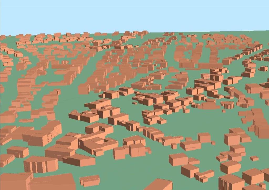
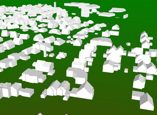
18 3D-Building Data LoD1 and LoD2


19 Police, Fire Departments, Rescue Services: Risk Management Cartographic basis for operational planning and subsequent documentation Large-scale deployment planning Special thematic mapping: hydrographic maps, forest fire operation maps Simulation of flood scenarios, identification of possibly affected buildings, calculation of volumes of water + 2m
20 1. Introduction - Smart Cities and Geodata 2. Geodata in Germany 3. Examples 4. Data and Service Delivery 5. Conclusions

21 AdV-Bereitstellungsstrategie Geobasisdaten Web Services For Geodata Delivery Customer Focus Capture, Maintenance and Delivery Standards Access and Catalogue Services INSPIRE and GDI-DE Quality Management Economicalness Online- Services with uniform licensing arrangements Harmonised Geospatial Reference Data


22 Maintenance of: AdV Customer Centres Coordinating bodies Supra-regional users, focal points Linked to Europe Same fees and measuring standards Customer Centres for products of the German official surveying and mapping Satellite Positioning Service of the German State Survey Building coordinates and polygons of the German Real Estate Cadastre Geodata of the German State Survey Lower Saxony North Rhine- Westphalia Federal Office for Geodesy and Cartography
23 1. Introduction - Smart Cities and Geodata 2. Geodata in Germany 3. Examples 4. Data and Service Delivery 5. Conclusions
24 Conclusions Land ownership and tenure structures are key elements of a smart development approach. A participatory and transparent approach to spatial planning and relevant implementation processes is critical. Integrated and standardised geospatial datasets accessible through services within spatial data infrastructures (SDI) are fundamental to success for well-informed decision-making in both urban and rural areas. Smart cities are geospatially enabled cities! 23 November
GEOMATICS. Shaping our world. A company of
 GEOMATICS Shaping our world A company of OUR EXPERTISE Geomatics Geomatics plays a mayor role in hydropower, land and water resources, urban development, transport & mobility, renewable energy, and infrastructure
E-Government and SDI in Bavaria, Germany
 135 E-Government and SDI in Bavaria, Germany Wolfgang STOESSEL, Germany Key words: GDI-BY, Bavaria, Spatial Data Infrastructure SUMMARY Spatial Data Infrastructure (SDI) is an important part of the e-government
Spatial Information Management in the Context of Organizational Development the Approach in North-Rhine Westphalia, Germany
 Spatial Information Management in the Context of Organizational Development the Approach in North-Rhine Westphalia, Germany Dr. Jens Riecken DVW Vice President c/o Ministry of the Interior North-Rhine
Norwegian spatial data infrastructure supporting disaster risk management Norwegian Mapping Authority
 Norwegian spatial data infrastructure supporting disaster risk management Norwegian Mapping Authority Arvid Lillethun, Norwegian Mapping Authority Land and Poverty 2018 Conference, World Bank 19.-23. March
Compact guides GISCO. Geographic information system of the Commission
 Compact guides GISCO Geographic information system of the Commission What is GISCO? GISCO, the Geographic Information System of the COmmission, is a permanent service of Eurostat that fulfils the requirements
SDI Implementation at the Local
 SDI Implementation at the Local Administration Level of Germany Hartmut Müller and Stephan von St. Vith FIG Working Week 2009 Surveyors Key Role in Accelerated Development, Eilat, Israel, 3-8 May 2009
Adding value to Copernicus services with member states reference data
 www.eurogeographics.org Adding value to Copernicus services with member states reference data Neil Sutherland neil.sutherland@os.uk GIS in the EU 10 November 2016 Copyright 2016 EuroGeographics 61 member
Applied spatial data for sustainable development strategy in Germany
 Applied spatial data for sustainable development strategy in Germany Stephan Arnold Areal Statistics, Federal Statistical Office, Germany Federal Statistical Office Headquarter: Wiesbaden Branch Office:
Spanish national plan for land observation: new collaborative production system in Europe
 ADVANCE UNEDITED VERSION UNITED NATIONS E/CONF.103/5/Add.1 Economic and Social Affairs 9 July 2013 Tenth United Nations Regional Cartographic Conference for the Americas New York, 19-23, August 2013 Item
Innovation in Land Management: Integrated Solutions For National Cadastre Projects
 Success With GIS Innovation in Land Management: Integrated Solutions For National Cadastre Projects XXIII International FIG Congress Munich These documents are only complete, when used in connection with
Building a National Data Repository
 Building a National Data Repository Mladen Stojic, Vice President - Geospatial 1/30/2013 2012 Intergraph Corporation 1 Information has meaning and gives power only when shared and distributed. Information,
Land Use in the context of sustainable, smart and inclusive growth
 Land Use in the context of sustainable, smart and inclusive growth François Salgé Ministry of sustainable development France facilitator EUROGI vice president AFIGéO board member 1 Introduction e-content+
ISO Series Standards in a Model Driven Architecture for Landmanagement. Jürgen Ebbinghaus, AED-SICAD
 ISO 19100 Series Standards in a Model Driven Architecture for Landmanagement Jürgen Ebbinghaus, AED-SICAD 29.10.2003 The Company 100% SIEMENS PTD SIEMENS Business Services Shareholder & Strategic Business
European Spatial Data Research. EuroSDR. Prof. Dr. Ir. Joep Crompvoets. General Assembly CLGE Tirana 18 March
 EuroSDR Prof. Dr. Ir. Joep Crompvoets General Assembly CLGE - 2016 Tirana 18 March 2016 INTRODUCTORY QUESTIONS Who knows what is EuroSDR? Who does NOT know what is EuroSDR? Who is employed at mapping agencies?
The Integrated Ge spatial Information Framework to the strengthening of NSDI, Mongolia
 Young Geospatial Professionals Summit 21 NOV 2018 The Integrated Ge spatial Information Framework to the strengthening of NSDI, Mongolia BAYARMAA ENKHTUR Geospatial information and technology department
Evolution and development of National Spatial Data Infrastructure in Republic of Moldova
 Agency for Land Relations and Cadastre of the Republic of Moldova Evolution and development of National Spatial Data Infrastructure in Republic of Moldova Alexandru Morcov Deputy general director ALRC
Geoservices in Hamburg
 Geoservices in Hamburg Dr.-Ing. Winfried Hawerk Freie und Hansestadt Hamburg Landesbetrieb Geoinformation und Vermessung FIG Commission 7 Symposium Celje 16 May 2006 Hamburg and the Metropolitan Area Hamburg
SITMUN: Cooperating to Build Local SDIs in the Barcelona Region
 SITMUN: Cooperating to Build Local SDIs in the Barcelona Region Diputació de Barcelona Territory and Sustainability Area Territorial Information Systems Department INSPIRE CONFERENCE Barcelona, September
OPEN GOVERNMENT - BENEFITS OF INSPIRE IN THE PUBLIC SECTOR
 Brussels, 04th March 2013 - Daniela Hogrebe and André Caffier from GDI-DE 1 OPEN GOVERNMENT - BENEFITS OF INSPIRE IN THE PUBLIC SECTOR Powered by INSPIRE Open Government 2 SDI is a fundament of transparent
Implementing the Smart Growth Priority in an Open and Interoperable System for Geographic Data: Sardinia SITR- IDT
 REGION OF SARDINIA (ITALY) LOCAL AUTHORITY FOR MUNICIPALITIES, FINANCES AND URBAN PLANNING DEPT. FOR THE REGIONAL SPATIAL DATA INFRASTRUCTURE Implementing the Smart Growth Priority in an Open and Interoperable
INSPIRing effort. Peter Parslow Ordnance Survey December Various European approaches to managing an SDI
 INSPIRing effort Peter Parslow Ordnance Survey December 2015 Various European approaches to managing an SDI WHAT IS INSPIRE? A European Union Directive A community effort: http://inspire.ec.europa.eu/
Land Administration and Cadastre
 Geomatics play a major role in hydropower, land and water resources and other infrastructure projects. Lahmeyer International s (LI) worldwide projects require a wide range of approaches to the integration
Who are we? Use of German State s Rhineland-Palatinate Spatial Data Infrastructure for e-government INSPIRE. Topics of Presentation INSPIRE
 Who are we? University of Applied Sciences, Mainz, Germany Institute for Spatial Information and Surveying Technology Use of German State s Rhineland-Palatinate Spatial Data Infrastructure for e-government
I&CLC2000 in support to new policy initiatives (INSPIRE, GMES,..)
") I&CLC2000 in support to new policy initiatives (INSPIRE, GMES,..) Manfred Grasserbauer, Director Joint Research Centre Institute for Environment and Sustainability 1 IMAGE 2000 European mosaic of satellite
I&CLC2000 in support to new policy initiatives (INSPIRE, GMES,..) Manfred Grasserbauer, Director Joint Research Centre Institute for Environment and Sustainability 1 IMAGE 2000 European mosaic of satellite
The German GDI a public-private cooperation project. Heinz BRÜGGEMANN Surveying and Mapping Agency NRW, Germany
 The German GDI a public-private cooperation project Heinz BRÜGGEMANN Surveying and Mapping Agency NRW, Germany Definition of Grimm Public tasks are all action lines..., which are handled by public actors,
Information Technology and Spatial Data Infrastructure for E-Government
 Technology and Hartmut Müller Who are we? University of Applied Sciences, Mainz, Germany Institute for Spatial and Surveying Technology Who are we? University of Applied Sciences, Mainz, Germany Institute
SDI Development in Georgia. Mari Khardziani Head of International Relations Unit National Agency of Public Registry
 SDI Development in Georgia Mari Khardziani Head of International Relations Unit National Agency of Public Registry Kehl, Germany September 5, 2017 2 National Agency of Public Registry Legal Entity of Public
GIS Building Communities beyond National Borders (Building Successful Spatial Data Infrastructures) Nick Land, ESRI Europe
 Nick Land, ESRI Europe") GIS Building Communities beyond National Borders (Building Successful Spatial Data Infrastructures) Nick Land, ESRI Europe UK worst flooding in the last 60 years 350,000 households without drinking water
GIS Building Communities beyond National Borders (Building Successful Spatial Data Infrastructures) Nick Land, ESRI Europe UK worst flooding in the last 60 years 350,000 households without drinking water
Introduction. Elevation Data Strategy. Status and Next Steps
 1 2 Introduction Elevation Data Strategy Status and Next Steps 3 Canada is the 2nd largest country in the world - 9.9 million sq km Surrounded by 3 oceans with 202 000 km of coastline Population over 35
Challenges and Potentials of Place Based Information Management in Nepal"
 Nineteenth United Nations Regional Cartographic Conference for Asia and the Pacific, Bangkok, Thailand, 29 October 1 November 2012 Challenges and Potentials of Place Based Information Management in Nepal"
SDI Development in the Russian Federation
 , the Russian Federation Key words: SDI development, the Russian Federation SUMMARY A reform in the field of spatial data is gathering headway in Russia. Creation of a single agency, which united state
INSPIRE - A Legal framework for environmental and land administration data in Europe
 INSPIRE - A Legal framework for environmental and land administration data in Europe Dr. Markus Seifert Bavarian Administration for Surveying and Cadastre Head of the SDI Office Bavaria Delegate of Germany
Upgrade the Datasets in NSDI for Smarter Services with the Cases of China
 Upgrade the Datasets in NSDI for Smarter Services with the Cases of China By Dr. JIANG Jie Dept of GeoInformaiton Service Platform National Geomatics Center of China October 7, 2015 Jeju, Republic of Korea
Applying Hazard Maps to Urban Planning
 Applying Hazard Maps to Urban Planning September 10th, 2014 SAKAI Yuko Disaster Management Expert JICA Study Team for the Metro Cebu Roadmap Study on the Sustainable Urban Development 1 Contents 1. Outline
Georeferencing and Satellite Image Support: Lessons learned, Challenges and Opportunities
 Georeferencing and Satellite Image Support: Lessons learned, Challenges and Opportunities Shirish Ravan shirish.ravan@unoosa.org UN-SPIDER United Nations Office for Outer Space Affairs (UNOOSA) UN-SPIDER
"GIS-Sofia" Ltd. geospatial data integration in SOFCAR geographic information system and providing services March 2018, Sofia
 "GIS-Sofia" Ltd. geospatial data integration in SOFCAR geographic information system and providing services Geographical Information System Sofia " Ltd....the beginning... Established in 1999, as a Sofia
The UN-GGIM: Europe core data initiative to encourage Geographic information supporting Sustainable Development Goals Dominique Laurent, France
 INSPIRE conference Strasbourg 6 September 2017 The UN-GGIM: Europe core data initiative to encourage Geographic information supporting Sustainable Development Goals Dominique Laurent, France Introduction
TIM-online A part of the egovernment strategy by the Federal State North-Rhine Westphalia
 TIM-online A part of the egovernment strategy by the Federal State North-Rhine Westphalia Stefan Sandmann Surveying and mapping agency of North - Rhine Westphalia Muffendorfer Straße 19 21, D-53177 Bonn
Ready for INSPIRE.... connecting worlds. European SDI Service Center
 Ready for INSPIRE Consultancy SOFTWARE T r a i n i n g Solutions... connecting worlds European SDI Service Center Increasing Added Value with INSPIRE and SDI Components INSPIRE In 2007, the European Commission
a national geological survey perspective François ROBIDA BRGM (French Geological Survey)
") a national geological survey perspective François ROBIDA BRGM (French Geological Survey) Pre-Conference Seminar on Socio-Economic Value of Geospatial for National and Regional Development 21 August 2017,
a national geological survey perspective François ROBIDA BRGM (French Geological Survey) Pre-Conference Seminar on Socio-Economic Value of Geospatial for National and Regional Development 21 August 2017,
Global Geospatial Information Management Country Report Finland. Submitted by Director General Jarmo Ratia, National Land Survey
 Global Geospatial Information Management Country Report Finland Submitted by Director General Jarmo Ratia, National Land Survey Global Geospatial Information Management Country Report Finland Background
Statistical-geospatial integration - The example of Sweden. Marie Haldorson Director, Statistics Sweden
 Statistical-geospatial integration - The example of Sweden Marie Haldorson Director, Statistics Sweden Spatial data and geospatial applications at Statistics Sweden Long tradition GI integrated in production
GEO-Government in Baden-Wuerttemberg Strategy on INSPIRE-Coordinates, Nodes and Standards
 INSPIRE Conference 2017: Thinking out of the box GEO-Government in Baden-Wuerttemberg Strategy on INSPIRE-Coordinates, Nodes and Standards Dipl. Ing. Dieter Heß Ministry of Rural Affairs and Consumer Protection
TWG BU State of Play November 2010
 TWG BU State of Play November 2010 TWG BU members General methodology Existing data Use cases User requirements Existing standards Modelling approach Next steps Plan of presentation TWG BU members TWG
Geographic information for Strasbourg : from historical land register to 3D GIS city modelling 09/07/2017
 Geographic information for Strasbourg : from historical land register to 3D GIS city modelling 09/07/2017 Table of contents 1. Introduction of Strasbourg 2. A century of land surveying and cadastre 3.
IRDAT Fvg, evolving a regional Spatial Data Infrastructure according to INSPIRE
 IRDAT Fvg, evolving a regional Spatial Data Infrastructure according to INSPIRE Tutti i diritti riservati. Proprietà INSIEL SpA. A. Benvenuti, A. Chiarandini Insiel (Italy) M. Lunardis - Friuli Venezia
Status of spatial information in the Republic of Moldova
 AGENCY FOR LAND RELATIONS AND CADASTRE OF MOLDOVA Status of spatial information in the Republic of Moldova Vasile GRAMA, Maria OVDII, Agency for Land Relations and Cadastre ovdii@agency.cadastre.md CONTENTS
SDI Implementation at the Local Administration Level of Germany
 Hartmut MÜLLER and Stephan von St. VITH, Germany Key words: SDI, Municipality, egovernment, Geospatial Basic Data SUMMARY Germany is a federal republic consisting of 16 states (so called "Laender"). At
Project based approach developing National Spatial Data Infrastructure in Lithuania
 Project based approach developing National Spatial Data Infrastructure in Lithuania National Land Service under the Ministry of Agriculture of The Republic of Lithuania Cadastres & Geodesy Department Director
Emerging Trends in Institutional Arrangements Europe - Finland
 Emerging Trends in Institutional Arrangements Europe - Finland Arvo Kokkonen Deputy Director General National Land Survey of Finland 1 Contents Facts about Finland National Land Survey of Finland European
Pal NIKOLLI Bashkim IDRIZI Ismail KABASHI Adelajda HALILI THE IMPLEMENTATION OF NATIONAL SPATIAL DATA INFRASTRUCTURE IN ALBANIA
 Pal NIKOLLI Bashkim IDRIZI Ismail KABASHI Adelajda HALILI THE IMPLEMENTATION OF NATIONAL SPATIAL DATA INFRASTRUCTURE IN ALBANIA Overview: Goals of paper Some definitions of SDI NSDI Development NSDI in
Zagreb Spatial Data Infrastructure. Sanja Batić, APIS IT Split, 14. rujna 2011.
 Zagreb Spatial Data Infrastructure Sanja Batić, APIS IT Split, 14. rujna 2011. Agenda Zagreb Spatial Data Infrastructure - ZIPP Guidelines for further ZIPP Geoportal development Conclusion 1964 The Centre
Country Case Studies Norway- The Norwegian national spatial data infrastructure improve risk management and of disaster resilience
 Country Case Studies Norway- The Norwegian national spatial data infrastructure improve risk management and of disaster resilience Arvid Lillethun Norwegian Mapping Authority Land Mapping Division arvid.lillethun@kartverket.no
State of Israel Ministry of Housing and Construction Survey of Israel. The Hydrological project case
 State of Israel Ministry of Housing and Construction Survey of Israel The Hydrological project case Survey of Israel Content Introduction To the Survey of Israel The operation assumptions The main responsibilities
To achieve these Global Sustainable Development Goals, geospatial data are crucial.
 To achieve these Global Sustainable Development Goals, geospatial data are crucial. 2 http://www.globalgoals.org/ HIGH INCOME NATION SUSTAINABLE GROWTH SOCIALLY INCLUSIVE 3 http://etp.pemandu.gov.my/ 12
Grant Agreement No. EIE/07/595/SI BEn
 Biomass energy register for sustainable site development for European regions Grant Agreement No. EIE/07/595/SI2.499697 BEn Biomass energy register for sustainable site development for European regions
INSPIRE Basics. Vlado Cetl European Commission Joint Research Centre. https://ec.europa.eu/jrc/
 INSPIRE Basics Vlado Cetl European Commission Joint Research Centre https://ec.europa.eu/jrc/ Serving society Stimulating innovation Supporting legislation Outline SDI? Why European SDI? INSPIRE Policy
The National Spatial Strategy
 Purpose of this Consultation Paper This paper seeks the views of a wide range of bodies, interests and members of the public on the issues which the National Spatial Strategy should address. These views
STEREO ANALYST FOR ERDAS IMAGINE Stereo Feature Collection for the GIS Professional
 STEREO ANALYST FOR ERDAS IMAGINE Stereo Feature Collection for the GIS Professional STEREO ANALYST FOR ERDAS IMAGINE Has Your GIS Gone Flat? Hexagon Geospatial takes three-dimensional geographic imaging
National Geospatial Platforms Solution to interoperability challenge in Europe. Antti Jakobsson Programme manager National Land Survey of Finland
 National Geospatial Platforms Solution to interoperability challenge in Europe Antti Jakobsson Programme manager National Land Survey of Finland 1 Questionnaire made in 2017: Google search: Public Geospatial
GIS FOR MAZOWSZE REGION - GENERAL OUTLINE
 GIS FOR MAZOWSZE REGION - GENERAL OUTLINE S. Bialousz 1), K Mączewski 2), E. Janczar 2), K. Osinska-Skotak 1) 1) Warsaw University of Technology, Warsaw, Poland 2) Office of the Surveyor of the Mazowieckie
v1.0 Session: Managing a national names programme Pier-Giorgio Zaccheddu
 Session: Managing a national names programme v1.0 Pier-Giorgio Zaccheddu Federal Agency for Cartography and Geodesy (BKG) Department of Geo Information Richard-Strauss-Allee 11 60598 Frankfurt am Main
EuroSDR (European Spatial Data Research)
") EuroSDR (European Spatial Data Research) ROLLING RESEARCH PLAN 2015-2018 EuroSDR Secretariat Public Governance Institute KU Leuven Parkstraat 45 bus 3609 3000 Leuven Belgium Tel.: +32 16 32 31 80 Fax:
EuroSDR (European Spatial Data Research) ROLLING RESEARCH PLAN 2015-2018 EuroSDR Secretariat Public Governance Institute KU Leuven Parkstraat 45 bus 3609 3000 Leuven Belgium Tel.: +32 16 32 31 80 Fax:
Portfolio of karteco Cadastral Survey Department
 Portfolio of karteco Cadastral Survey Department 01-2016 Who we are? karteco Environmental & Energy Engineering Consultancy Founding members: Apostolos Karteris Dr. Environmental Engineer Marinos Karteris
A Case Study on Local SDI Implementation in Germany
 A Case Study on Local SDI Implementation in Germany Hartmut MÜLLER, Falk WÜRRIEHAUSEN, Germany Key words: Local SDI, Municipality, Commune SDI, Geospatial Basic Data, Geospatial Thematic Data, Web Service,
Ministry of ICT of I.R.IRAN
 The ECO 8/6 mill km 2 10 Slamic countries ~330 mill people Oil, Gas, Industries,Tourism 2 Issue transformation in last decade Problem solving needs more integrated approach More interaction &complexity
SUPPORTS SUSTAINABLE GROWTH
 DDSS BBUUN NDDLLEE G E O S P AT I A L G O V E R N A N C E P A C K A G E SUPPORTS SUSTAINABLE GROWTH www.digitalglobe.com BRISBANE, AUSTRALIA WORLDVIEW-3 30 CM International Civil Government Programs US
Modular Web Framework for the BRANDENBURGVIEWER
 Modular Web Framework for the BRANDENBURGVIEWER Geoinformation System (GIS) 2 GIS = geo + information + system + + Survey of data Organization of data Processing and Analysis Presentation geodata infrastructure
Stay of play in the Serbian geo-sector
 Stay of play in the Serbian geo-sector Republic Geodetic Authority, Serbia IGN France International, France INSPIRE Conference Florence, 27 th June 2013 Outline NSDI status Institutional framework Technical
Country Report On Sdi Activities In Singapore ( )
") UNITED NATIONS E/CONF.102/IP.4 ECONOMIC AND SOCIAL COUNCIL Nineteenth United Nations Regional Cartographic Conference for Asia and the Pacific Bangkok, 29 October 1 November 2012 Item 6(b) of the provisional
UNITED NATIONS E/CONF.102/IP.4 ECONOMIC AND SOCIAL COUNCIL Nineteenth United Nations Regional Cartographic Conference for Asia and the Pacific Bangkok, 29 October 1 November 2012 Item 6(b) of the provisional
Geospatial SDI Portal for effective Governance of Pune METROPOLIS region
 Geospatial SDI Portal for effective Governance of Pune METROPOLIS region Mr. Praveen Gautam Senior Manager 19 th January 2018 PMRDA Overview Provide a Spatial Framework for the entire region with various
Preparation of Database for Urban Development
 Preparation of Database for Urban Development By PunyaP OLI, 1. Chairman, ERMC (P) Ltd., Kathmandu, Nepal. Email: punyaoli@ermcnepal.com 2. Coordinator, Himalayan College of Geomatic Engineering and Land
ArcGIS for INSPIRE. Marten Hogeweg
 ArcGIS for INSPIRE Marten Hogeweg Please Take Our Survey on the App Download the Esri Events app and find your event Select the session you attended Scroll down to find the feedback section Complete answers
Tomas Mildorf New technologies for the information society University of west bohemia in pilsen, Czech republic
 Tomas Mildorf New technologies for the information society University of west bohemia in pilsen, Czech republic Karel Charvat Help Service Remote Sensing, Czech republic AIP-7 GEOSS, 20 MAY 2014 By 2015,
THE BEST POLICY (SMART) DECISIONS COME FROM SPATIALLY CONNECTED GOVERNMENT
 DECISIONS COME FROM SPATIALLY CONNECTED GOVERNMENT") THE BEST POLICY (SMART) DECISIONS COME FROM SPATIALLY CONNECTED GOVERNMENT Andy Wilson Ordnance Survey International andy.wilson@osi.os.uk Geospatial World Forum, Rotterdam, May 24th Mapping is everywhere
THE BEST POLICY (SMART) DECISIONS COME FROM SPATIALLY CONNECTED GOVERNMENT Andy Wilson Ordnance Survey International andy.wilson@osi.os.uk Geospatial World Forum, Rotterdam, May 24th Mapping is everywhere
Manitoba s Elevation (LiDAR) & Imagery Datasets. Acquisition Plans & Opportunities for Collaboration
 & Imagery Datasets. Acquisition Plans & Opportunities for Collaboration") Manitoba s Elevation (LiDAR) & Imagery Datasets Acquisition Plans & Opportunities for Collaboration Manitoba Planning Conference May 2017 Presentation Outline Manitoba s Elevation (LiDAR) and Imagery Datasets
Manitoba s Elevation (LiDAR) & Imagery Datasets Acquisition Plans & Opportunities for Collaboration Manitoba Planning Conference May 2017 Presentation Outline Manitoba s Elevation (LiDAR) and Imagery Datasets
Prof Chryssy Potsiou, FIG President
 THE VALUE OF GEOSPATIAL DATA AND ROLE OF SURVEYORS IN SUSTAINABLE DEVELOPMENT Prof Chryssy Potsiou, FIG President National Technical University of Athens School of Rural and Surveying Engineering, Greece
Features and Benefits
 Autodesk LandXplorer Features and Benefits Use the Autodesk LandXplorer software family to help improve decision making, lower costs, view and share changes, and avoid the expense of creating physical
Overview of CityGML. Dave Capstick, Ordnance Survey Research Department
 Overview of CityGML Dave Capstick, Ordnance Survey Research Department Introduction Why is citygml necessary CityGML development who is responsible? Ordnance Surveys interest 3D modelling basic concepts
Monitoring of Settlement Development Methodological Problems and Solutions in Germany
 Monitoring of Settlement Development Methodological Problems and Solutions in Germany Gotthard Meinel Leibniz Institute for Ecological Urban and Regional Development (IOER), Germany/Dresden Overview LU-Problem
EO Information Services. Assessing Vulnerability in the metropolitan area of Rio de Janeiro (Floods & Landslides) Project
 Project") EO Information Services in support of Assessing Vulnerability in the metropolitan area of Rio de Janeiro (Floods & Landslides) Project Ricardo Armas, Critical Software SA Haris Kontoes, ISARS NOA World
EO Information Services in support of Assessing Vulnerability in the metropolitan area of Rio de Janeiro (Floods & Landslides) Project Ricardo Armas, Critical Software SA Haris Kontoes, ISARS NOA World
A Broad View of Geospatial Technology & Systems
 A Broad View of Geospatial Technology & Systems Pete Large Vice President, Trimble On the shoulders of giants 1 Since their time, our ability to generate geospatial information has grown exponentially
Land Accounts - The Canadian Experience
 Land Accounts - The Canadian Experience Development of a Geospatial database to measure the effect of human activity on the environment Who is doing Land Accounts Statistics Canada (national) Component
EuroGeographics & INSPIRE. Nick Land, Executive Director of EuroGeographics
 EuroGeographics & INSPIRE Nick Land, Executive Director of EuroGeographics EuroGeographics A growing association 49 Members, 42 countries Topographic mapping, cadastre, land registry + Networked organisation
NSDI as a tool for Secure land tenure
 NSDI as a tool for Secure land tenure General Overview To look at the progress in SDI development and its application in policy formulation and impact on land tenure. INTEGRATION OF INFORMATION POLICIES
Imagery and the Location-enabled Platform in State and Local Government
 Imagery and the Location-enabled Platform in State and Local Government Fred Limp, Director, CAST Jim Farley, Vice President, Leica Geosystems Oracle Spatial Users Group Denver, March 10, 2005 TM TM Discussion
IDEBarcelona: Cooperating for a Smart Region Infrastructure
 IDEBarcelona: Cooperating for a Smart Region Infrastructure Marta Codinachs Serra Diputació de Barcelona Territory and Sustainability Area Territorial Information Systems Department SMART CITY EXPO WORLD
Demonstration of a local SDI solution with several stakeholders in pilot areas in line with EU best practices
 EU Twinning project for the Agency of Land Relations and Cadaster (ALRC)- Organization, Streamlining and Computerization Process in Mapping in the Republic of Moldova. Demonstration of a local SDI solution
ESDIN Results from a Crossborder INSPIRE Preparatory Project. Jörgen Hartnor, Lantmäteriet.
 ESDIN Results from a Crossborder INSPIRE Preparatory Project Jörgen Hartnor, Lantmäteriet www.esdin.eu Ett econtentplus Best Practice Network projekt September 2008 February 2011 Coordinated by EuroGeographics
Influence of INSPIRE on European/national data specifications
 www.eurogeographics.org Influence of INSPIRE on European/national data specifications Saulius Urbanas, EuroGeographics 20 th June 2017 Copyright 2013 EuroGeographics EuroGeographics 46 European countries
Proposal for a DIRECTIVE OF THE EUROPEAN PARLIAMENT AND OF THE COUNCIL. establishing an infrastructure for spatial information in the Community
 Proposal for a DIRECTIVE OF THE EUROPEAN PARLIAMENT AND OF THE COUNCIL establishing an infrastructure for spatial information in the Community INSPIRE http://inspire.jrc.it/ Alessandro Annoni 1 EU Commission
Building a national spatial data infrastructure. Thorben Hansen, Head of Division Danish Agency for Data Supply and Efficiency
 Building a national spatial data infrastructure Thorben Hansen, Head of Division Danish Agency for Data Supply and Efficiency About Spatial Data Infrastructure Spatial data come from many sources and is
Study Visit University of Applied Sciences Utrecht Netherlands
 Study Visit University of Applied Sciences Utrecht Netherlands Directorate-General for Territorial Development Lisbon 1 April 2014 1 Agenda Presentation Cadastre Department Surveying / Geodesy Department
Funding systems used in Mexico to support institutional arrangements: INEGI case
 Funding systems used in Mexico to support institutional arrangements: INEGI case Sistemas de financiamiento usados en México, para soportar arreglos institucionales: Caso INEGI United Nations Committee
A donor partner view. Olaf Magnus Østensen. 'Modernization of spatial data infrastructure to reduce risks and impacts of floods'
 A donor partner view Olaf Magnus Østensen 'Modernization of spatial data infrastructure to reduce risks and impacts of floods' About the EEA Grants programme http://eeagrants.org/ Beneficiary country Donor
Data Origin. Ron van Lammeren CGI-GIRS 0910
 Data Origin Ron van Lammeren CGI-GIRS 0910 How to obtain geodata? Geo data initiative Executive Order 12906, "Coordinating Geographic Data Acquisition and Access: The National Spatial Data Infrastructure,"
Plan4all (econtentplus project)
") Plan4all (econtentplus project) Karel CHARVAT 1, Tomáš MILDORF 2 1 Help service remote sensing, Ltd., Černoleská 1600, 256 01 Benešov u Prahy, Czech Republic charvat@bnhelp.cz 2 Department of Mathematics
Plan4all (econtentplus project) Karel CHARVAT 1, Tomáš MILDORF 2 1 Help service remote sensing, Ltd., Černoleská 1600, 256 01 Benešov u Prahy, Czech Republic charvat@bnhelp.cz 2 Department of Mathematics
Work Group A «Core Data» Report and Update François Chirié, Dominique Laurent, France
 JOINT UN-GGIM: EUROPE ESS MEETING ON THE INTEGRATION OF STATISTICAL AND GEOSPATIAL INFORMATION LUXEMBOURG 11 MARCH 2016 Work Group A «Core Data» Report and Update François Chirié, Dominique Laurent, France
Exploit your geodata to enable smart cities and countries
 Exploit your geodata to enable smart cities and countries Carsten Rönsdorf, Head of Advisory Services Middle East Practice Manager Future Cities, standards and 3D 24 November 2014 Importance of Standards
Land Board, NW Services and SDI Tambet Tiits, FRICS
 Land Board, NW Services and SDI Tambet Tiits, FRICS 07.09.2016 200th anniversary of the Struve Geodetic Arc Friedrich Georg Wilhelm Struve and Carl Friedrich Tenner Struve Geodetic Arc The Struve Geodetic