Copernicus for Raw Materials Workshop
|
|
|
- Lindsey Green
- 5 years ago
- Views:
Transcription

1 Copernicus for Raw Materials Workshop Copernicus 40 User Years Forum Listening Industry Workshop, to the Beat 5th September of the Earth 2016, Brussels
2 About The objective of this workshop is to propose effective measures to support Copernicus uptake from private intermediate and end users. Specifically, the workshop will focus on the area of raw materials and extractive industries, as well as identifying potential research and development needs. In the raw material sector, several tasks within the mining lifecycle can be supported by means of remote sensing. This workshop will highlight potential Copernicus contributions to the extractive industries domain while focusing on new and emerging needs of the sector. The long term aim is to build an EU-level community of remote sensing users and service developers in the industry of raw materials and extractive industries

3 About Copernicus for Raw Materials Workshop 1. Earth Observation and Geohazards Expert Group 2. Earth Observation for Raw materials Geological mapping Mineral mapping Mining monitoring 3. Potential research and development needs 4. EGS community building


4 1. Earth Observation and Geohazards Expert Group Mission and vision 28 GSs Apply Earth Observation technology to improve geoscience delivery on geohazards and raw materials lyfe cycle Deliver harmonized Earth Observation based geo-information improving the operational capacity and economic capabilities of governments, institutions, organizations, businesses and individuals. 4


5 2. Earth Observation and Geohazards Expert Group Working groups: Geohazards: subsidence and landslide WG Leaded by Gerardo Herrera (IGME), Earth Observation and Exploration WG Leaded by Veronika Kopackova (CGS), 5

6 3. Earth Observation for Raw Materials EGS applies and develops EO-based methods and tools to improve the interaction between the mineral extractive industry and society for its sustainable development while improving its societal acceptability. 6
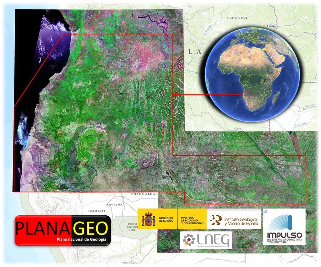
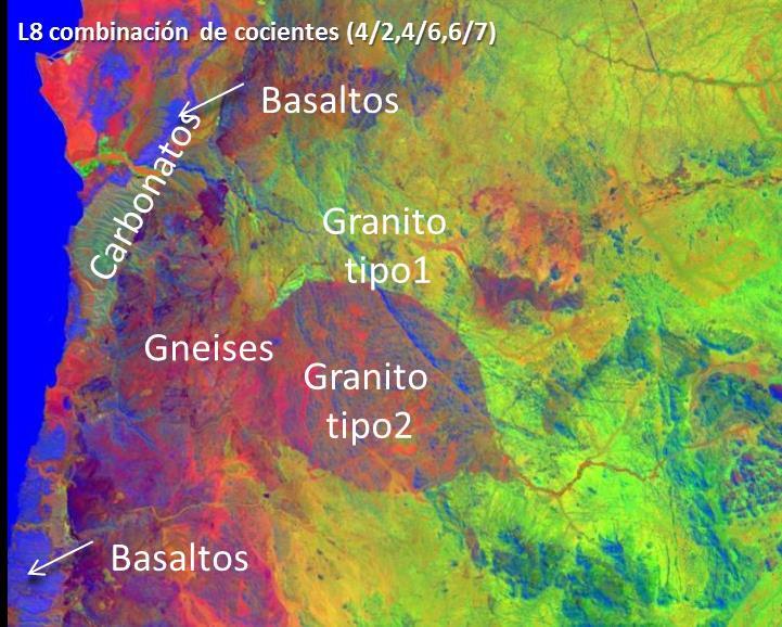
7 Geological mapping Angola Geology map


.")
8 Mineral mapping Mineral thematic map showing surface geological materials from hyperspectral data Sokolov Lignite Open-Pit Mines, Czech Republic Higher Quartz content Notesco, G. Kopačková V. Rojík, P. Schwartz, G. Livne, I. Ben-Dor, E. (2014): Mineral Classification of Land Surface Using Multispectral LWIR and Hyperspectral SWIR Remote-Sensing Data. A Case Study over the Sokolov Lignite Open-Pit Mines, the Czech Republic. Remote Sensing 6, 8, ISSN (on line). DOI /rs Higher Phyllosilicatescontent


9 Mineral mapping: Acid Mine drainage Mining waste mapping derived from hyperspectral data and field meaurements Case study, S. Domingos Mine Iberian pyrite Belt Quental, L. Sousa, A.J, Marsh, S., Brito, G. Abreu, M.M. (2011) Imaging spectroscopy answers to acid mine drainage detection, Iberian Pyrite Belt, Portugal. Comunicações Geológicas, 98,

10 Mineral mapping: quantitative ph evaluation Soil ph map derived from mineral association using hyperspectral imagery 10
 Kopačková V. Hladíková, L.")

11 Mineral mapping: surface water mineral content Mapping surface water parameters from hyperspectral and HR optical satellite (Worldview 2) Kopačková V. Hladíková, L. (2014): Applying Spectral Unmixing to Determine Surface Water Parameters in a Mining Environment. Remote Sensing 6, 11, ISSN DOI /rs
![Mineral mapping: Sentinel-2 evaluation Sentinel-2 data preliminar evaluation for mineral mapping partially successful 1st derivative analysis Unclassified Region #1 [Red] 21 points](/docs-images/93/114317263/images/12-1.jpg "Region #2 [Green] 27 points Region #3 [Blue] 19 points Unclassified tuffs, claystones Region #4 [Yellow] 22 points Region lignite #1 [Red] 21 Region tuffs, points claystones #5")
![[Cyan] (iron oxides) 22 points Region kaolinite #2 [Green] Region 27 tuffs, points claystones #6 [Magenta] (jarosit) 21 points Region tuffs, claystones #3 [Blue] with19 lignite](/docs-images/93/114317263/images/12-2.jpg "Region points#7 [Maroon] 28 points Region #4 [Yellow] Copernicus User Forum Industry Workshop, 5th September 2016, Region 22 points Brussels #8 [Sea Green] 10 poin Region #5 [Cyan]")
12 Mineral mapping: Sentinel-2 evaluation Sentinel-2 data preliminar evaluation for mineral mapping partially successful 1st derivative analysis Unclassified Region #1 [Red] 21 points Region #2 [Green] 27 points Region #3 [Blue] 19 points Unclassified tuffs, claystones Region #4 [Yellow] 22 points Region lignite #1 [Red] 21 Region tuffs, points claystones #5 [Cyan] (iron oxides) 22 points Region kaolinite #2 [Green] Region 27 tuffs, points claystones #6 [Magenta] (jarosit) 21 points Region tuffs, claystones #3 [Blue] with19 lignite Region points#7 [Maroon] 28 points Region #4 [Yellow] Copernicus User Forum Industry Workshop, 5th September 2016, Region 22 points Brussels #8 [Sea Green] 10 poin Region #5 [Cyan] 22 points
![Unclassified Region #1 [Red] 5 points Mineral mapping: EnMAP simulation Region #2 [Green] 5 points Region Unclassified #3 [Blue] 4 points Simulation Region of #1 #4 EnMap [Red] [Yellow] 5 points data](/docs-images/93/114317263/images/13-1.jpg "5 points to test mineral mapping potential of the future hyperspectral satellite - EnMap Region Unclassified #2 #5 [Green] [Cyan] 75 points Unclassified Region #3 #6 #1 [Blue] [Magenta] [Red] 54")
13 Unclassified Region #1 [Red] 5 points Mineral mapping: EnMAP simulation Region #2 [Green] 5 points Region Unclassified #3 [Blue] 4 points Simulation Region of #1 #4 EnMap [Red] [Yellow] 5 points data 5 points to test mineral mapping potential of the future hyperspectral satellite - EnMap Region Unclassified #2 #5 [Green] [Cyan] 75 points Unclassified Region #3 #6 #1 [Blue] [Magenta] [Red] 54 points 5 points tuffs enriched #1 [Red] in jarosite 5 points Region #4 #7 #2 [Yellow] [Maroon] [Green] 523 points points kaolinized#2 tuffs [Green] 5 Region #5 #8 #3 [Cyan] [Sea [Blue] Green] 47 points 14 points clays (iron-bearing minerals and #3 [Blue] lignite) 4 points Region #6 #10 #4 [Magenta] [Yellow] [Coral] 514 points 5 points #4 [Yellow] 5 kaolinized #9 #5 tuffs [Purple] [Cyan] with lignite Region #7 [Maroon] 711 points 23 points claystones #5 rich [Cyan] in ferric7 points Region minerals #8 #11 #6 [Sea [Magenta] [Aquamarine] Green] 5 points 145 points Region lignite #6 [Magenta] 5 points Region #10 #12 #7 [Maroon] [Coral] [Orchid] points Region cypris clays #7 mixed [Maroon] with 23 points Region #13 #8 [Sea [Sienna] Green] 5 14 points lignite #9 [Purple] 11 points Region #8 [Sea Green] 14 points Region kaolinite (fresh) #11 #14 #10 [Aquamarine] [Chartreuse] [Coral] 14 points 20 5 points Region #10 [Coral] 14 points Region weathered #12 #15 #9 claystones [Purple] [Orchid] [Thistle] points Region #9 [Purple] 11 points Region #13 #11 [Aquamarine] [Sienna] 5 points 5 points Region #11 [Aquamarine] 5 points Region #14 #12 [Chartreuse] [Orchid] 8 points 20 points
14 4. Potential reseach and development needs Mineral mapping: developping models for quantitative assessment of physical and chemical surface properties (mines, post-mining areas, remediation's) using Sentinel-2 and EnMap satellite data Building a world-wide mineral/rock/soil reflectance and emissivity libraries


15 Mining monitoring: InSAR Detection of underground coal mining subsidence in urban areas using Radar Interferometry: USCB (Poland) Przyłucka, M.; Herrera, G.; Graniczny, M.; Colombo, D.; Béjar-Pizarro, M. Combination of Conventional and Advanced DInSAR to Monitor Very Fast Mining Subsidence with TerraSAR-X Data: Bytom City (Poland). Remote Sens. 2015, 7,


16 Mining monitoring: tailing dumps instabilities Detection and monitoring of ground instabilities related to mining tailing dumps based on satellite radar interferometry Herrera et al. Mapping ground movements in open pit mining areas using differential SAR interferometry. International Journal of Rock Mechanics and Mining Sciences, 2010, vol. 47, no 7, p

17 Mining monitoring: Sentinel 1 service level Monitoring mining activity every 12-6 days is possible Target: active mines, abandoned mines, mining waste and induced anthropogenic hazards
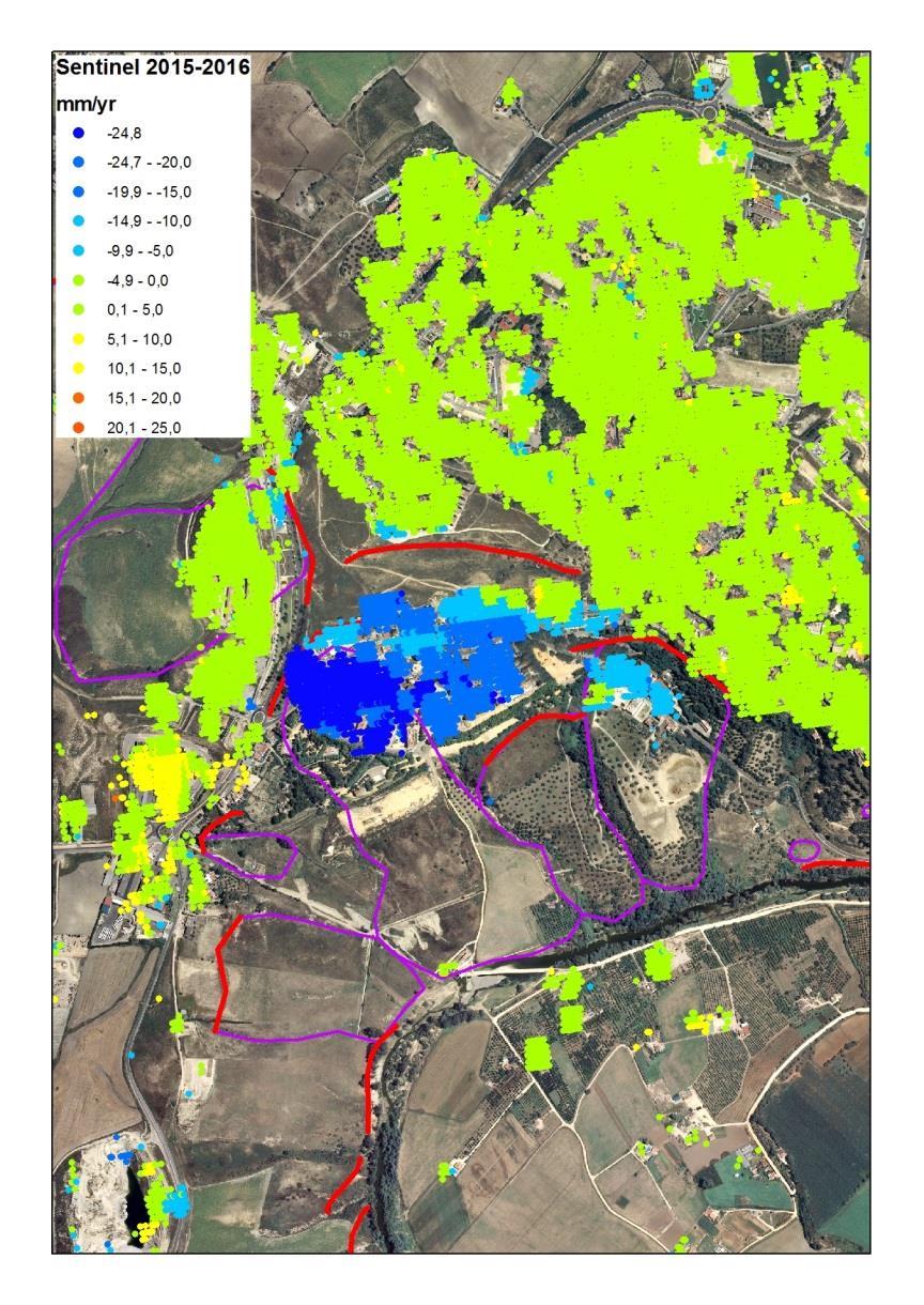
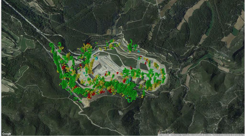
18 Mining monitoring: Sentinel 1


19 Mining monitoring: Sentinel 1 Acumulated displacement April November 2015 of a waste dam
20 4. Potential reseach and development needs Monitoring mining environments Potential: Sentinel 1 provides, for the first time, a low cost do it yourself opportunity to provide continuous monitoring of mining with InSAR What is needed? Knowledge transfer to end users (public and private) Provide cloud computing access (national level?) Who can/should act? EU level visibility project.- Terrafirma, PanGeo EU directive in antropogenic & mass movement hazards?
21 EGS community building on Earth Observation for Raw Materials EOEG is contributing to build a community of remote sensing users and service developers in the industry of raw materials and extractive industries, through: GEO-Cradle PanAfGeo collaboration with OAGS (Geological Surveys Africa) LATAM MOU with ASGMI (Geological Surveys Latinamerica) New Geo Community of Activity


22 GEO-Cradle Coordinating and integrating state-of-the Art Earth Observation Activities in the regions of North Africa, Middle East, and Balkans and Developing Links with GEOSS

")
23 Increasing geoscientific Knowledge & Skills for the Raw Materials in African Geological Surveys The course Introduction to remote sensing from EOEG to EGS will focus on: Remote sensing sources fro mapping geology & minerals Measuring ground deformations from radar data The 1 st training will take place in Bishoftu (Ethiopia, 35 km SE from Addis Ababa) in 2017


24 New Geo Community of Activity (CA) Earth observation for Geohazards, land degradation and Environmental monitoring Proposed and leaded by EOEG To be included in GEO 2017 work programme Exploit current and emerging Earth Observation (EO) technologies that provide regular top- surface compositional information with a high temporal rate and high spatial resolution from: Optical, hyperspectral thermal and radar imageries Target: anthropogenic hazards
25 Copernicus 40 User Years Forum Listening Industry Workshop, to the Beat 5th September of the Earth 2016, Brussels
40 Years Listening to the Beat of the Earth
 EU-LA Mining & Exploration Convention Earth Observation in support of sustainable mining by the Geological Surveys of Europe Gerardo Herrera Veronika Kopačková Eleftheria Poyiadji Maria Przyłucka 40 Years
Addressing GEO-CRADLE regional challenges - Access to raw materials MINUTES
 Observation Activities in the regions of North Africa, Middle East, and Addressing GEO-CRADLE regional challenges - Access to raw materials MINUTES The GEO-CRADLE project has received funding from the
Change Detection Over Sokolov Open Pit Mine Areas, Czech Republic, Using Multi Temporal HyMAP Data ( )
") Change Detection Over Sokolov Open Pit Mine Areas, Czech Republic, Using Multi Temporal HyMAP Data (2009 2010) S. Adar* a G. Notesco b, A. Brook b, I. Livne b, P. Rojik c, V. Kopackova d, K. Zelenkova
Change Detection Over Sokolov Open Pit Mine Areas, Czech Republic, Using Multi Temporal HyMAP Data (2009 2010) S. Adar* a G. Notesco b, A. Brook b, I. Livne b, P. Rojik c, V. Kopackova d, K. Zelenkova
Introduction of Remote Sensing Methods for Monitoring the Under Restoration Amiantos Mine, Cyprus
 Sixth International Conference on Remote Sensing and Geoinformation of Environment, 26-29 March, 2018 - Cyprus Introduction of Remote Sensing Methods for Monitoring the Under Restoration Amiantos Mine,
Call for Applications
 Call for Applications for a PanAfGeo Training «WP1 Geoscientific Mapping, part WP1E1 Remote Sensing» 20-30 November 2017, Bishoftu, Ethiopia in English 1. MAIN CONTEXT OF PANAFGEO PanAfGeo for Pan-African
Towards best practices for using satellite Earth Observation in mining and extractives
 Towards best practices for using satellite Earth Observation in mining and extractives EU-Latin America Mining & Exploration Convention and Trade Show METS 2018 11 April 2018 Madrid Marriott Auditorium
OVERALL PROGRAMME. Sunday 16 October 2016:
 Sunday 16 October 2016: OVERALL PROGRAMME - Arrival in Morocco (landing either in Casablanca, with transfers to hotel to be organized by EGS, or Rabat) - Hosted dinner for the European Geological Surveys,
GEO-CRADLE Project Meeting 2 Thursday, 17 th November, 2016
 GEO-CRADLE Project Meeting 2 Thursday, 17 th November, 2016 T4.3 EGS-PGI NRI Marek Graniczny (EGS PGI) Maria Przyłucka (EGS PGI) Eleftheria Poyiadji (EGS-IGME-Greece) Zbigniew Kowalski (EGS PGI) Christodoulos
EuroGeoSurveys & ASGMI The Geological Surveys of Europe and IberoAmerica
 EuroGeoSurveys & ASGMI The Geological Surveys of Europe and IberoAmerica Geological Surveys, what role? Legal mandate for data & information: Research Collection Management Interpretation/transformation
EuroGeoSurveys An Introduction
 EGS -ASGMI Workshop, Madrid, 2015 EuroGeoSurveys An Introduction 40 Years Listening to the Beat of the Earth Click to edit Master title Albania style EuroGeoSurveys Austria Lithuania Luxembourg Belgium
EO-MINERS and Minerals 4EU
 GEO-CRADLE pre-kick-off Meeting Friday, 18 th of February, 2016 Veronika Kopačková, Czech Geological Survey EO-MINERS and Minerals 4EU IONIC Centre, 11 Lysiou Street Athens, Greece EO-MINERS (2010-2013)
Earth Observation and GEOSS in Horizon Copernicus for Raw Material Workshop 5 th September 2016
 Earth Observation and GEOSS in Horizon 2020 Copernicus for Raw Material Workshop 5 th September 2016 Gilles OLLIER Head of Sector -Earth observation Directorate Environment Unit I.4 Climate Actions and
EO, Land Motion and Climate Adaptation in Mediterranean Cities June 2014, Athens
 EO, Land Motion and Climate Adaptation in Mediterranean Cities 10-11 June 2014, Athens 1 Context UN Report: Water and Cities Facts and Figures 2 Context UN Report: Water and Cities Facts and Figures 3
Infrastructure monitoring using SAR interferometry
 Infrastructure monitoring using SAR interferometry Hossein Nahavandchi Roghayeh Shamshiri Norwegian University of Science and Technology (NTNU), Department of Civil and Environmental Engineering Geodesy
EO-MINERS. Contribution of Earth Observation in monitoring the environmental and societal impact of mining. The EO-MINERS project
 EO-MINERS Contribution of Earth Observation in monitoring the environmental and societal impact of mining The EO-MINERS project Geospatial World Forum Amsterdam April 25, 2012 Stéphane CHEVREL Project
ADVANCED MINERAL MAPPING USING VISIBLE TO NEAR INFRARED, SHORTWAVE AND LONGWAVE INFRARED HIGH SPECTRAL RESOLUTION DATA
 ADVANCED MINERAL MAPPING USING VISIBLE TO NEAR INFRARED, SHORTWAVE AND LONGWAVE INFRARED HIGH SPECTRAL RESOLUTION DATA Veronika Kopačková, Lucie Koucká Overview Concept of our approach, QUANTOOLS into
C o p e r n i c u s a n d W I G O S
 C o p e r n i c u s a n d W I G O S Jean-Noël Thépaut & Mark Dowell 24 October 2017 GEO XIV, Washington DC, 23-28 October 2017 T h e C o p e r n i c u s P r o g r a m m e Copernicus is the European Union
A1 - Total Land Use by Mining and Milling topographical footprint
 A. LAND-USE A1 - Total Land Use by Mining and Milling topographical footprint Topographical Footprint: The total areal footprint (2-dimensional) used by the mine/mill is an overarching proxy for a variety
EuroGeoSurveys. Minerals, metals and mining statistics: The role of Geological Surveys in building continental-scale official data sets
 EuroGeoSurveys Minerals, metals and mining statistics: The role of Geological Surveys in building continental-scale official data sets 40 Years Listening to the Beat of the Earth 1 EuroGeoSurveys 37 Geological
GEO-CRADLE Regional Event Access to raw materials. Veronika Kopačková, Czech Geological Survey EO-MINERS
 GEO-CRADLE Regional Event Access to raw materials Veronika Kopačková, Czech Geological Survey EO-MINERS Morocco&Algeria 17-23 October 2016 EO-MINERS (2010-2013) EO-MINERS was a Research and Technological
Geological information for Europe : Towards a pan-european Geological Data Infrastructure
 Geological information for Europe : Towards a pan-european Geological Data Infrastructure Integrating geoscientific information for EU competitiveness Co-funded by the European Union European societal
40 Years Listening to the Beat of the Earth
 EuroGeoSurveys The role of EuroGeoSurveys in Europe-Africa geoscientific cooperation 40 Years Listening to the Beat of the Earth EuroGeoSurveys 32 Albania Lithuania Austria Luxembourg Belgium The Netherlands
Advancing Geoscientific Capability. Geological Survey of Finland
 Advancing Geoscientific Capability Geological Survey of Finland GTK in brief The Geological Survey of Finland (GTK) is one of the largest European centres of excellence in assessment, research and the
Satellite ASTER Global Geoscience Maps
 Satellite ASTER Global Geoscience Maps Michael Abrams Jet Propulsion Laboratory, California Institute of Technology, Pasadena USA (c) 2017 California Institute of Technology. Government sponsorship acknowledged.
Cristina Ananasso Copernicus Unit DG GROW. H2020 Space: Calls on Earth Observation and Copernicus Ilan Ramon Conference 28/01/2018 Tel Aviv
 Cristina Ananasso Copernicus Unit DG GROW H2020 Space: Calls on Earth Observation and Copernicus Ilan Ramon Conference 28/01/2018 Tel Aviv OUTLINE Call Space 2018-2020 - Earth Observation and Copernicus
EO4SEE - THE PATHFINDER OF OPERATIONAL SATELLITE MONITORING FOR THE REGION OF THE BLACK SEA AND CENTRAL EUROPE
 EO4SEE: Pathfinder assessment for regional high volume data access, processing and information service delivery platforms - South East Region EO4SEE - THE PATHFINDER OF OPERATIONAL SATELLITE MONITORING
Copernicus for Raw Materials: making the potential fully operational
 Raw Materials Week 2018 12 th November 2018, Le Plaza Hotel, Boulevard Adolphe Max 118-126, 1000 Brussels Copernicus for Raw Materials: making the potential fully operational 1. Nature of the meeting This
THE FEASIBILITY AND APPLICATION OF PSI TO DETECT A RANGE OF GROUND AND STRUCTURE MOTION PHENOMENA.
 THE FEASIBILITY AND APPLICATION OF PSI TO DETECT A RANGE OF GROUND AND STRUCTURE MOTION PHENOMENA. Rachel Holley, InSAR Surveying Consultant InSAR Surveying Team Fugro NPA Satellite Mapping Introduction
Urban areas & climate change
 Urban areas & climate change Paolo Gamba University of Pavia University of Pavia The UNIPV TLC & RS Lab is a dynamic research group developing in the past years many techniques devoted to the analysis
Key words: global monitoring, disaster control, coal fires, China
 Remote-sensing GIS based investigations of coal fires in northern China; global monitoring to support the estimation of CO 2 emissions from spontaneous combustion of coal Freek van der Meer, Paul van Dijk,
Hyper-Spectral and Copernicus Evolution
 Hyper-Spectral and Copernicus Evolution Antonio Ciccolella - ESA Roma, 1 March 2017 Issue/Revision: 0.0 Reference: ESA UNCLASSIFIED Status: - For Official Use ESA UNCLASSIFIED - For Official Use Hyperspectral
Copernicus Space Component Status & Evolution
 Copernicus Space Component Status & Evolution ESCAP, Bangkok 09 October 2017 Simon Jutz Head of the ESA Copernicus Space Office Directorate of Earth Observation Programmes 28 satellites in development
The role of soil spectral library for the food security issue
 The role of soil spectral library for the food security issue Eyal Ben-Dor Department of Geography Tel Aviv University The GEO-CRADLE project has received funding from the European Union s Horizon 2020
Eyal Ben-Dor Department of Geography Tel Aviv University
 Spectral Imaging of Soils: past present and future Eyal Ben-Dor Department of Geography Tel Aviv University 2nd International Conference on Airborne Research for the Environment, DLR - the German Aerospace
Remote Sensing and EO activities at the University of Turku
 Remote Sensing and EO activities at the University of Turku Niina Käyhkö Associate Professor Department of Geography and Geology GEO meeting/syke May 23rd, 2018 Geospatial competence at the University
German-Peruvian Workshop on Research Cooperation on Raw Materials of Strategic Economic Importance
 German-Peruvian Workshop on Research Cooperation on Raw Materials of Strategic Economic Importance Friday, 25 of September 2015 Sonesta Hotel El Olivar Research activities in the field of economical strategic
Supporting GPSC Cities with Satellite Earth Observation for Sustainable Urban Development
 Supporting GPSC Cities with Satellite Earth Observation for Sustainable Urban Development Global Platform for Sustainable Cities African Regional Workshop 14 May 2018 AfDB Headquarters Abidjan, Côte d'ivoire
The Joint Programming Initiative on Cultural Heritage (JPICH): European perspective
: European perspective") COPERNICUS FOR CULTURAL HERITAGE Copernicus User Forum Industry Workshop Brussels, 24 April 2017 The Joint Programming Initiative on Cultural Heritage (JPICH): European perspective Cristina Sabbioni CNR,
COPERNICUS FOR CULTURAL HERITAGE Copernicus User Forum Industry Workshop Brussels, 24 April 2017 The Joint Programming Initiative on Cultural Heritage (JPICH): European perspective Cristina Sabbioni CNR,
GMES-based Geoservices for Mining Areas
 GMES-based Geoservices for Mining Areas Dr. Andreas Müterthies EFTAS Fernerkundung GmbH Oststraße 2-18 48145 Münster Das Projekt wird unterstützt aus Mitteln der EU und des Landes Nordrhein-Westfalen This
APPLYING SPECTRAL UNMIXING TO DETERMINE SURFACE WATER PARAMETERS IN MINING ENVIRONMENT
 EARSeL eproceedings, Special Issue: 34 th EARSeL Symposium, 2014 41 APPLYING SPECTRAL UNMIXING TO DETERMINE SURFACE WATER PARAMETERS IN MINING ENVIRONMENT Veronika Kopačková 1, and Lenka Hladíková 2 1.
EuroGeoSource project
 3/18/2011 Stephan Gruijters, coordinator Euro Geo Source EuroGeoSource project -WP4- Harmonisation of the georesources attributes and the data exchange format Jasna Šinigoj, Duška Rokavec Geological Survey
The Future of Remote Sensing
 The Future of Remote Sensing BELSPO - 30 Years of Remote Sensing Research 17 September 2015, Brussels Research and Michael Berger Earth Observation Sector Directorate Climate Action and Resource Efficiency
The Global Statistical Geospatial Framework and the Global Fundamental Geospatial Themes
 The Global Statistical Geospatial Framework and the Global Fundamental Geospatial Themes Sub-regional workshop on integration of administrative data, big data and geospatial information for the compilation
EU collaborations with NASA LCLUC Program & Current Priorities
 & Current Priorities ioannis Manakos, Dr. Centre for Research and Technology Hellas Information Technologies Institute Visual Analytics, Virtual & Augmented Reality Laboratory European Association of Remote
A contribution to GEOSS from the SDI for Georesources in Africa
 A contribution to GEOSS from the SDI for Georesources in Africa A. TELLEZ-ARENAS BRGM, France in behalf of: Dr. Marc URVOIS Project Coordinator BRGM, France Mineral Resources Division INSPIRE Conference
Land subsidence induced by groundwater extraction in the Alto Guadalentín aquifer, SE Spain.
 Land subsidence induced by groundwater extraction in the Alto Guadalentín aquifer, SE Spain. Pablo Ezquerro, Marta Béjar-Pizarro, Gerardo Herrera, José A. Fernández Merodo, Roberto Tomás, Carolina Guardiola-Albert,
The Safeland Project General Overview and Monitoring Technology Development
 Ber. Geol. B. A., 82, ISSN 1017 8880 Landslide Monitoring Technologies & Early Warning Systems The Safeland Project General Overview and Monitoring Technology Development The SafeLand Consortium a), N.
Copernicus Schaffung einer europäischen Kapazität für die operationelle Erdbeobachtung
 Copernicus Schaffung einer europäischen Kapazität für die operationelle Erdbeobachtung ESOC, Darmstadt, 23 April 2015 Simon Jutz, ESA Head, Copernicus Space Office (EOP-CO) Earth Observation Programmes
GEO-VIII November Geohazard Supersites and Natural Laboratories Progress Report. Document 9
 GEO-VIII 16-17 November 2011 Geohazard Supersites and Natural Laboratories Progress Report Document 9 This document is submitted to GEO-VIII for information. Geohazard Supersites and Natural Laboratories
Pilot applications for Greece and Egypt related end-users
 GEO-CRADLE Project Meeting 2 16 th November, 2016 Pilot applications for Greece and Egypt related end-users Panagiotis Kosmopoulos & Hesham El-Askary National Observatory of Athens Chapman University Eratosthenes
Urban Mapping. Sebastian van der Linden, Akpona Okujeni, Franz Schug 11/09/2018
 Urban Mapping Sebastian van der Linden, Akpona Okujeni, Franz Schug 11/09/2018 Introduction to urban remote sensing Introduction The urban millennium Source: United Nations, 2014 Urban areas mark extremes
Evaluating the information content of National ASTER Geoscience Maps in the Wagga Wagga and Cobar regions of New South Wales
 Evaluating the information content of National ASTER Geoscience Maps in the Wagga Wagga and Cobar regions of New South Wales The National ASTER Geoscience Maps, freely available from CSIRO/GA (https://data.csiro.au/dap/
GMES Initial Operations- Network for Earth Observation Research and Training
 GMES Initial Operations- Network for Earth Observation Research and Training Sybrand van Beijma, Dr. Virginia Nicolás-Perea, Prof. Heiko Balzter Centre for Landscape and Climate Research, University of
sentinel-2 COLOUR VISION FOR COPERNICUS
 sentinel-2 COLOUR VISION FOR COPERNICUS SATELLITES TO SERVE By providing a set of key information services for a wide range of practical applications, Europe s Copernicus programme is providing a step
Pilot applications for Egypt related end-users
 GEO-CRADLE Regional Workshop Thursday, 25 th May, 2017 Pilot applications for Egypt related end-users Hesham El-Askary Chapman University Panagiotis Kosmopoulos National Observatory of Athens Stelios Kazadzis
IDENTIFICATION AND CHANGES OF SUBSIDENCE BASINS CAUSED BY COAL MINING ACTIVITY IN UPPER SILESIA USING SATELLITE INTERFEROMETRIC DATA
 IDENTIFICATION AND CHANGES OF SUBSIDENCE BASINS CAUSED BY COAL MINING ACTIVITY IN UPPER SILESIA USING SATELLITE INTERFEROMETRIC DATA Maria Przyłucka (1), Marek Graniczny (1), Zbigniew Kowalski (1) (1)
Space Applications for Disaster Risk Reduction and Sustainable Development
 Space Applications for Disaster Risk Reduction and Sustainable Development Space Applications Section (SAS) ICT and Disaster Risk Reduction Division (IDD) UNESCAP Contents I. RESAP Activities 2016-2017
Integrating geography and statistics, but what about earth observation?
 Integrating geography and statistics, but what about earth observation? 8 0 0 y 2 2 3 0 9 x 6 3 9 1 9 n 1 8 3 7 3 9 7 2 2 4 8 8 7 8 4 7 5 Ola Nordbeck Senior Advisor Ola.nordbeck@spacecentre.no Bridging
ANALYSIS OF VERTICAL MOVEMENTS DETECTED BY RADAR INTERFEROMETRY IN URBAN AREAS
 10TH CZECH-POLISH WORKSHOP ON RECENT GEODYNAMICS OF THE SUDETEN AND ADJACENT AREAS Szklarska Poręba, Poland, November 5 7, 2009 ANALYSIS OF VERTICAL MOVEMENTS DETECTED BY RADAR INTERFEROMETRY IN URBAN
EuroGEOSS Protected Areas Pilot
 EuroGEOSS Protected Areas Pilot Max Craglia European Commission Joint Research Centre Part 1: the present MyNatura2000 Mobile app. Awareness raising & volunteered data collection. Natura2000 covers 18%
Feasibility Study: GEOSCIENTIFIC KNOWLEDGE AND SKILLS OF AFRICAN GEOLOGICAL SURVEYS. WP 3 - Gap analysis of geoscientific mapping
 Feasibility Study: GEOSCIENTIFIC KNOWLEDGE AND SKILLS OF AFRICAN GEOLOGICAL SURVEYS WP 3 - Gap analysis of geoscientific mapping Acquisition of metadata to geological maps as base for the compilation of
Czech Geological Survey Remote sensing unit
 Czech Geological Survey Remote sensing unit CGS Remote sensing unit Who we are? Part of the Dpt. of Regional geology of crystalline complexes Since 2005 Processing of satellite and airborne data Geoinformation
Sentinel-1 Mission Status
 Sentinel-1 Mission Status Pierre Potin, Sentinel-1 Mission Manager, ESA Luca Martino, Technical Support Engineer, ESA... and the Sentinel-1 operations team PSTG SAR Coordination Working Group 14 December
Excel Geomatics: Offering Excellence with Unique Consultancy & Services
 Excel Geomatics: Offering Excellence with Unique Consultancy & Services Providing consultancy and value Added Services using Remote Sensing, Photogrammetry and LiDAR in areas such as Agriculture, Forestry,
Space research. Horizon Work Programme. "Countdown to Horizon 2020 Space" Earth Observation topics. Brussels, 12 December 2013
 Space research Horizon 2020 - Work Programme "Countdown to Horizon 2020 Space" Earth Observation topics Brussels, 12 December 2013 richard.gilmore@ec.europa.eu Table of contents FP/Copernicus - general
Activity 6.3 Geoscience information infrastructure and management
 G E O S C I E N T I F I C K N O W L E D G E A N D S K I L L S I N A F R I C A N G E O L O G I C A L S U R V E Y S Activity 6.3 Geoscience information infrastructure and management CAG25 - TW4 Workshop
Analysis of mining deformations based on PSInSAR technique case study of the Walbrzych coal mines (Poland)
") Analysis of mining deformations based on PSInSAR technique case study of the Walbrzych coal mines (Poland) Dr. Jan Blachowski, Dr. Wojciech Milczarek Faculty of Geoengineering, Mining and Geology, Wroclaw
Analysis of mining deformations based on PSInSAR technique case study of the Walbrzych coal mines (Poland) Dr. Jan Blachowski, Dr. Wojciech Milczarek Faculty of Geoengineering, Mining and Geology, Wroclaw
Alteration zone Mapping in the Meiduk and Sar Cheshmeh Porphyry Copper Mining Districts of Iran using Advanced Land Imager (ALI) Satellite Data
 Satellite Data") Alteration zone Mapping in the Meiduk and Sar Cheshmeh Porphyry Copper Mining Districts of Iran using Advanced Land Imager (ALI) Satellite Data Amin Beiranvand Pour*, Mazlan Hashim Geoscience and Digital
Alteration zone Mapping in the Meiduk and Sar Cheshmeh Porphyry Copper Mining Districts of Iran using Advanced Land Imager (ALI) Satellite Data Amin Beiranvand Pour*, Mazlan Hashim Geoscience and Digital
Potential of Earth Observation to address global challenges of cities
 Potential of Earth Observation to address global challenges of cities Copernicus for Future cities workshop, 9 November 2018, Brussels Session III: cities challenges, user needs and innovation paths Marc
Geological Mapping Using EO Data for Onshore O&G Exploration
 Geological Mapping Using EO Data for Onshore O&G Exploration Michael Hall ESA Oil and Gas Workshop, Frascati, Italy michael.hall@infoterra-global.com Why use EO data for Geological Mapping? Availability
THE ROLE OF SEAMIC IN SUSTAINABLE MINERAL RESOURCES DEVELOPMENT IN AFRICA
 THE ROLE OF SEAMIC IN SUSTAINABLE MINERAL RESOURCES DEVELOPMENT IN AFRICA Ketema Tadesse Director General-SEAMIC Dar es Salaam, Tanzania August 11, 2009 SEAMIC BACKGROUND SEAMIC was established in 1977
The Safety project: Updating geohazard activity maps with Sentinel-1data
 The Safety project: Updating geohazard activity maps with Sentinel-1data Oriol Monserrat a, Safety Consortium a Centre Tecnològic de Telecomunicacions de Catalunya (CTTC/CERCA), Division of Geomatics,
Call for Applications
 Call for Applications for a PanAfGeo Training «WP7 Geoscientific information Management» 20 November - 1 st December 2017 Accra, Ghana in English 1. MAIN CONTEXT OF PANAFGEO PanAfGeo for Pan-African Support
UN COPUOS 52 nd session of the Scientific and Technical Subcommittee. COPERNICUS - an European Achievement. S. Jutz Head, ESA Copernicus Space Office
 UN COPUOS 52 nd session of the Scientific and Technical Subcommittee COPERNICUS - an European Achievement S. Jutz Head, ESA Copernicus Space Office 11 Feb 2015, Vienna 1 2 What is Copernicus? European
The Geohazards Lab. CEOS WG Disasters. CEOS Disaster Risk Management. CEOS WG Disasters 10 th meeting
 CEOS Disaster Risk Management CEOS WG Disasters The Geohazards Lab CEOS WG Disasters 10 th meeting Philippe Bally, ESA Theodora Papadopoulou, ARGANS c/ ESA Michael Foumelis, BRGM CEOS WG Disasters Buenos
Integrated Space Applications in Transport, Energy & Safety Oil & Gas Exploration
 Exploration & Production Technology delivering breakthrough solutions Integrated Space Applications in Transport, Energy & Safety Oil & Gas Exploration Dr Colin Grant Engineering Technical Authority, Metocean
Ramani Geosystems. Putting Africa On The Map. Authorized Resellers
 Ramani Geosystems Putting Africa On The Map Authorized Resellers Ramani Profile Started in 1999 Aerial, Land Surveying & Mapping Solutions + 10 Countries in the region + 80 Staff working in projects Asset
OSS MISSION.
 GEO-CRADLE COORDINATING AND INTEGRATING STATE-OF-THE-ART EARTH OBSERVATION ACTIVITIES IN THE REGION OF NORTH OF AFRICA, MIDDLE EAST, AND BALKANS AND DEVELOPING LINKS WITH GEO RELATED INITIATIVES TOWARD
Urban remote sensing: from local to global and back
 Urban remote sensing: from local to global and back Paolo Gamba University of Pavia, Italy A few words about Pavia Historical University (1361) in a nice town slide 3 Geoscience and Remote Sensing Society
Framework Contract for Copernicus Service in Support to EU External Action Geospatial Production
 Framework Contract for Copernicus Service in Support to EU External Action Geospatial Production ANNEX E to the Tender Specifications SEA Portfolio Invitation to tender SATCEN-OP-01/17 Page 1 of 11 1.
The Global Geodetic Observing System (GGOS) of the International Association of Geodesy, IAG
 of the International Association of Geodesy, IAG") The Global Geodetic Observing System (GGOS) of the International Association of Geodesy, IAG Hans-Peter Plag (1), Markus Rothacher (2), Richard Gross (3), Srinivas Bettadpur (4) (1) Nevada Bureau of Mines
The Global Geodetic Observing System (GGOS) of the International Association of Geodesy, IAG Hans-Peter Plag (1), Markus Rothacher (2), Richard Gross (3), Srinivas Bettadpur (4) (1) Nevada Bureau of Mines
Georeferencing and Satellite Image Support: Lessons learned, Challenges and Opportunities
 Georeferencing and Satellite Image Support: Lessons learned, Challenges and Opportunities Shirish Ravan shirish.ravan@unoosa.org UN-SPIDER United Nations Office for Outer Space Affairs (UNOOSA) UN-SPIDER
LANDSLIDE MITIGATION IN CCOP
 "International Workshop on Landslide Risk Assessment and Management for ASEAN Member States 1-2 June 2017 Bangkok, Thailand LANDSLIDE MITIGATION IN CCOP Dr. Adichat Surinkum Director Email: adichat_s@ccop.or.th,
Esri and GIS Education
 Esri and GIS Education Organizations Esri Users 1,200 National Government Agencies 11,500 States & Regional Agencies 30,800 Cities & Local Governments 32,000 Businesses 8,500 Utilities 12,600 NGOs 11,000
C o p e r n i c u s M a r i n e S e r v i c e i n s u p p o r t t o s u s t a i n a b l e B l u e G r o w t h
 Implemented by C o p e r n i c u s M a r i n e S e r v i c e i n s u p p o r t t o s u s t a i n a b l e B l u e G r o w t h European Commission, DG MARE 19 Januray 2018 C O P E R N I C U S I N B R I E
Copernicus the European Space Programme for Earth Observation
 Copernicus the European Space Programme for Earth Observation http://www.copernicus.eu http://www.esa.int An Introduction Rome 2017 by Giorgio Bagnasco Issue/Revision: 0.0 Reference: ESA UNCLASSIFIED Status:
Applications of Remote Sensing Systems. to MINERAL DEPOSIT DISCOVERY, DEVELOPMENT
 REMS 6022: Term Project Applications of Remote Sensing Systems to MINERAL DEPOSIT DISCOVERY, DEVELOPMENT and RECLAMATION Venessa Bennett OVERVIEW Remote Sensing data extensively used in all aspects of
Space for Smarter Government Programme
 Space for Smarter Government Programme Development of Operational National Satellite Imaging Flood Mapping Capability Project Number: 59287-454144 Web: http://www.spaceforsmartergovernment.uk/ Email: ssgp@sa.catapult.org.uk
Geological Survey of Canada Lands and Minerals Sector Natural Resources Canada OneGeology, June 2018
 Geological Survey of Canada Lands and Minerals Sector Natural Resources Canada OneGeology, June 2018 Geological Survey of Canada Mission The Geological Survey of Canada provides public geoscience knowledge
The AMGI project: A Brief Overview
 The AMGI project: A Brief Overview World Bank Group (Energy & Extractives Global Practice) GEEDR Francisco Igualada (figualada@worldbank.org) Presented by Ash Johnson, Geosoft Inc. The AMGI Project: Vision
GEO Geohazards Community of Practice
 GEO Geohazards Community of Practice 1) Co-Chair of GHCP With input from: Stuart Marsh, GHCP Co-Chair Francesco Gaetani, GEO Secretariat and many GHCP contributors 1) Nevada Bureau of Mines and Geology
Copernicus Land Monitoring Service
 Geert van Seggelen g.vanseggelen@spaceoffice.nl Jasper van Loon j.vanloon@spaveoffice.nl Copernicus Land Monitoring Service User workshop 2018 Den Haag, 13 juni 2018 Doel van vandaag Informatie over producten
Land Cover and Asset Mapping Operational Change Detection
 Land Cover and Asset Mapping Operational Change Detection Andreas Müller DLR DFD with the support of Charly Kaufmann, Allan Nielsen, Juliane Huth ESA Oil & Gas Workshop, 13-14 September 2010 Folie 1 TWOPAC
Introduction of Remote Sensing Methods for Monitoring the Under Restoration Amiantos Mine, Cyprus
 Introduction of Remote Sensing Methods for Monitoring the Under Restoration Amiantos Mine, Cyprus Eleftheria Poyiadji *a,b, Marianthi Stefouli a,b, Maria Przyłucka b,c, Stanisław Wołkowicz c, Zbigniew
A prospective and retrospective spatial sampling scheme to characterize geochemicals in a mine tailings area
 A prospective and retrospective spatial sampling scheme to characterize geochemicals in a mine tailings area Pravesh Debba CSIR Built Environment Logistics and Quantitative Methods (LQM) South Africa Presented
GEOMATICS. Shaping our world. A company of
 GEOMATICS Shaping our world A company of OUR EXPERTISE Geomatics Geomatics plays a mayor role in hydropower, land and water resources, urban development, transport & mobility, renewable energy, and infrastructure
Introduction of the Asia-Oceania Global Earth Observation System of Systems (AOGEOSS) GEO Initiative(GI-22 )
 GEO Initiative(GI-22 )") Introduction of the Asia-Oceania Global Earth Observation System of Systems (AOGEOSS) GEO Initiative(GI-22 ) Prof. Xiang ZHOU Institute of Remote Sensing and Digital Earth, CAS 11 May 2017 Kunming, China
Introduction of the Asia-Oceania Global Earth Observation System of Systems (AOGEOSS) GEO Initiative(GI-22 ) Prof. Xiang ZHOU Institute of Remote Sensing and Digital Earth, CAS 11 May 2017 Kunming, China
Geo-hazard Potential Mapping Using GIS and Artificial Intelligence
 Geo-hazard Potential Mapping Using GIS and Artificial Intelligence Theoretical Background and Uses Case from Namibia Andreas Knobloch 1, Dr Andreas Barth 1, Ellen Dickmayer 1, Israel Hasheela 2, Andreas
RESAP Progress Report
 RESAP Progress Report December 2016 to October 2017 Presentation to the Twenty-first session of the Intergovernmental Consultative Committee on the Regional Space Applications Programme for Sustainable
Subsidence Monitoring in Hampton Roads Using Satellites
 ODU Digital Commons July 29, 2016: The Latest in Sea Level Rise Science Hampton Roads Sea Level Rise/Flooding Adaptation Forum 7-29-2016 Subsidence Monitoring in Hampton Roads Using Satellites Ben Hamlington