GEOLOGY OF PRAGUE ITS INTERACTION WITH THE PRAGUE METRO
|
|
|
- Pierce Terry
- 6 years ago
- Views:
Transcription
1 Underground M3 meeting, November 3-5, 2008, Prague GEOLOGY OF PRAGUE ITS INTERACTION WITH THE PRAGUE METRO Svatoslav Chamra Department of Geotechnics Faculty of Civil Engineering Czech Technical University in Prague


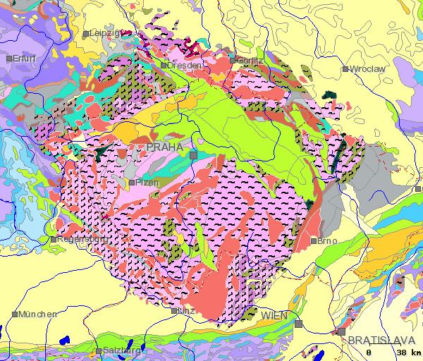
2 Czech Republic in geological system of Europe BARRANDIAN

3 Barrandian - geological basin from Proterozoic to Devonian
4 Barrandian The oldest rock complexes of the Upper Proterozoic are over 550 million years old. There prevail dark shales and grayish-green greywackes containing lenses of blackish-grey lydites. Proterozoic complexes were deformed by the Cadomian folding. Another marine transgression occurred in the Prague area at the beginning of the Ordovician. Ordovician sequences of strata are characterized by a multiple alternation of shale-dominated and sand-dominated facies, which form morphology of Prague. Firmer sand parts containing hard quartzites form elevations, whereas less resistant shale formations form depressions. The total thickness of the Ordovician deposits in the Prague area exceeds 2000 m.

5 Morphology of the Prague agglomeration


6 Longitudinal section of metro lines C, A C (superelevated profiles) A
7 Barrandian Complete sequence of marine deposits of the Silurian system is preserved with the total thickness of about 300 m. In its lower part prevail dark graptolitic shales, the upper part is characterized by mostly bioclastic limestones. The Devonian deposits lie on the Silurian sediments with no interruption in the marine carbonate sedimentation. The development of the Devonian sediments is characterized by the prevalence of limestones. The youngest formation is typical by the clayey-sandy lithological development, which reflecting the onset of the Variscan orogenic processes in the upper Middle Devonian.

8 Geological map of Prague (central part) Cretaceous Proterozoic Cretaceous Ordovician Silurian + Devonian Cambrian
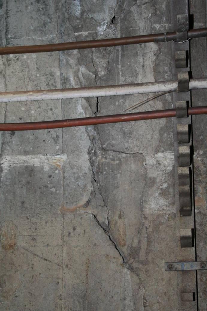
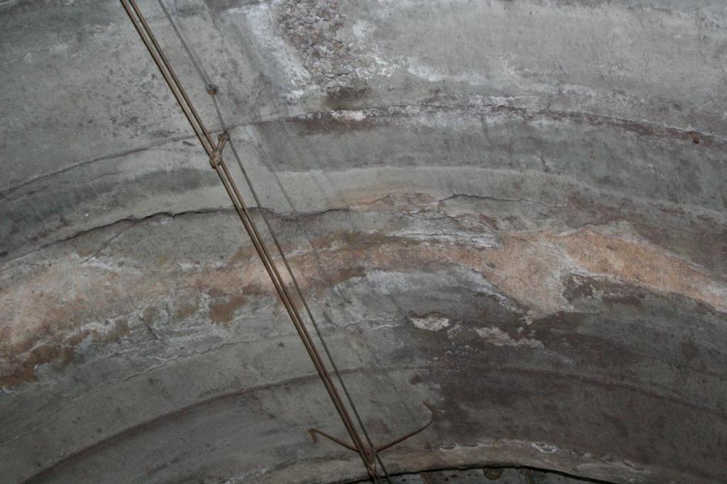
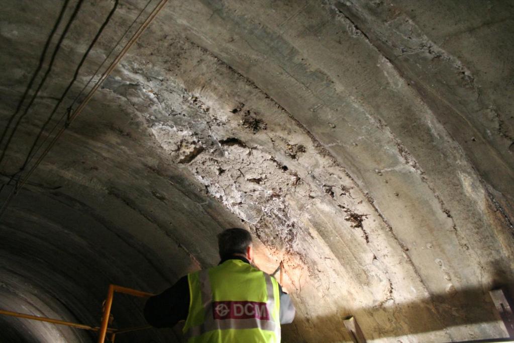
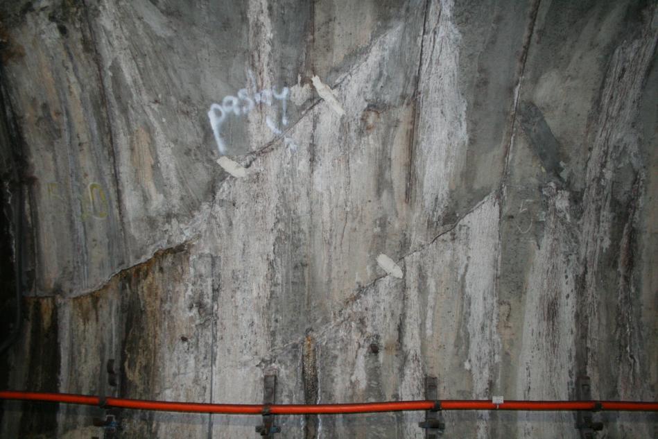
9 Tectonic failure Very interesting place is hence area in the vicinity of Můstek station, where metro lines (A, B) intersects. Furthermore there is tectonic failure called Prague fault. The width of this regional tectonic line is approximately 20 m. There are 3 types of tectonic deformation Ordovician clay shales zahoranske & bohdalecke & dobrotivske layers. The rock mass dislocated here by several hundred meters.

10 A


11 Realised project of junction Můstek Unrealised projects of junction Můstek

12 Realised project of junction Můstek

13 Prague fault in new railway tunnel under the VítkovV
14 TUNNELLING PROCEDURES The used tunnelling methods had to respect the difficult geological conditions in Prague and lessen the impact on the built-up, historically valuable parts of the city. The line tunnels were build using the following technology: "Prague" ring tunneling method with erector (in the solid rocks) Non-mechanized tunnelling shield (in the soft rocks and soils) Mechanized tunnelling shield TŠčB-3 (Soviet made) NATM (from the 80's) Cut and cover Launching method
15 Mechanized tunnelling shield TŠčB-3T This mechanized shield was used first on the running tunnels on the line A from the Malostranská station under the Vltava River to the Můstek station. The mechanized tunnelling shield with the cutter head of 5790 mm in diameter produced so called unreinforced press concrete lining 345 mm thick. The first TŠčB shield drove the 435 m long right tunnel under the Vltava river (the Vltava river is 195 m wide with an average water depth 4 m), was pulled through the Staroměstská station and continued by driving the running tunnel to the Můstek station. The second mechanized shield drove 420 m long left tunnel under the Vltava River and due to time constraints was dismantled in the Staroměstská station.

16 Cutter head of mechanized tunnelling shield TŠčB-3T

17 Assembling the mechanized shield in the underground assembling chamber

18 The view from assembling chamber to the driven tunnel tubes

19

20


21

22
23 Thank you for your attention!
NUMERICAL MODELLING OF THE BRUSNICE TUNNEL
 NUMERICAL MODELLING OF THE BRUSNICE TUNNEL Matouš Hilar 1, Jakub Nosek 2 1 D2 Consult Prague and FCE CTU, Zelený pruh 95/97, Prague 4, 140 00, Czech Republic 2 D2 Consult Prague, Zelený pruh 95/97, Prague
L.O: HOW GEOLOGISTS SEQUENCE EVENTS IN EARTH'S GEOLOGIC HISTORY IF NOT OVERTURNED, OLDEST ON BOTTOM, YOUNGEST ON TOP
 L.O: HOW GEOLOGISTS SEQUENCE EVENTS IN EARTH'S GEOLOGIC HISTORY IF NOT OVERTURNED, OLDEST ON BOTTOM, YOUNGEST ON TOP 1. Unless a series of sedimentary rock layers has been overturned, the bottom rock layer
Biology. Slide 1 of 40. End Show. Copyright Pearson Prentice Hall
 Biology 1 of 40 2 of 40 Fossils and Ancient Life What is the fossil record? 3 of 40 Fossils and Ancient Life The fossil record provides evidence about the history of life on Earth. It also shows how different
Ground settlement due to shield tunneling through gravelly soils in Hsinchu
 Japanese Geotechnical Society Special Publication The 15th Asian Regional Conference on Soil Mechanics and Geotechnical Engineering Ground settlement due to shield tunneling through gravelly soils in Hsinchu
Module 10: Resources and Virginia Geology Topic 4 Content: Virginia Geology Notes
 Virginia is composed of a very diverse landscape that extends from the beaches and barrier islands all of the way to the highly elevated Appalachian Plateau. Geologists have discovered ancient shallow
SAMPLE QUESTIONS FOR GEOLOGY 103, TEST 1
 SAMPLE QUESTIONS FOR GEOLOGY 103, TEST 1 The correct answers are listed at the bottom (no peeking!). These questions are to give you an idea of the type of questions that will be asked. They are not a
Application of the fractal fragmentation model to the fill of natural shear zones
 Application of the fractal fragmentation model to the fill of natural shear zones David Mašín Charles University, Institute of Hydrogeology, Engineering Geology and Applied Geophysics, Prague, Czech Republic
Geology Test Review Answers
 Name: Geology Test Review Answers Core: Fill in the blanks: 1. Sediments get compacted and cemented into sedimentary rock. 2. Igneous rocks can be intrusive or extrusive from a volcano. 3. Adding heat
Follow this and additional works at: Part of the Geology Commons
 Western Michigan University ScholarWorks at WMU Michigan Geological Repository for Research and Education Geosciences 2016 Geology of Michigan William B. Harrison III Michigan Geological Repository for
Rock mechanics as a significant supplement for cross-section balancing (an example from the Pavlov Hills, Outer Western Carpathians, Czech Republic)
") Trabajos de Geología, Universidad de Oviedo, 30 : 140-144 (2010) Rock mechanics as a significant supplement for cross-section balancing (an example from the Pavlov Hills, Outer Western Carpathians, Czech
Trabajos de Geología, Universidad de Oviedo, 30 : 140-144 (2010) Rock mechanics as a significant supplement for cross-section balancing (an example from the Pavlov Hills, Outer Western Carpathians, Czech
Structural Features and Fracture Orientation similarities between outcrops of the Ridgeley Sandstone
 The JUNIATA JOURNAL of GEOLOGY, 1, 1-8 (2014) Original article Structural Features and Fracture Orientation similarities between outcrops of the Ridgeley Sandstone Robert W. Baronner Two outcrops of the
Geotechnical Aspects of the Ohio River Bridges Project
 Geotechnical Aspects of the Ohio River Bridges Project Mark A. Litkenhus, PE Sr. Geotechnical Engineer Stephen H. Bickel, PE Sr. Geotechnical Engineer STGEC Ohio River Bridges at Louisville Geotechnical
GEOLOGIC MAPS PART II
 EARTH AND ENVIRONMENT THROUGH TIME LABORATORY - EES 1005 LABORATORY FIVE GEOLOGIC MAPS PART II Introduction Geologic maps of orogenic belts are much more complex than maps of the stable interior. Just
Geoscience 001 Fall Rock Identification and Contextual Interpretation
 Geoscience 00 Fall 2005 Rock Identification and Contextual Interpretation The purpose of this week s lab is to gain some more experience and practice in identifying rocks and then interpreting the geologic
3.0 GEOLOGY AND HYDROGEOLOGY
 3.0 GEOLOGY AND HYDROGEOLOGY 3.1 Methodology The Geological Survey of Ireland (GSI) publication Geology of South Cork was consulted to establish the nature of the bedrock lithology and Quaternary sediments.
Fossils, Geologic Time, Absolute & Relative Dating, and Natural Resources. Chapters 5 & 6
 Fossils, Geologic Time, Absolute & Relative Dating, and Natural Resources Chapters 5 & 6 How Do Fossils Form? Fossils are found in sedimentary rocks like sandstone, limestone, and shale In Virginia, most
GEOLOGY GL1 Foundation Unit
 Candidate Name Centre Number Candidate Number 2 General Certificate of Education Advanced Subsidiary/Advanced 451/01 GEOLOGY GL1 Foundation Unit P.M. THURSDAY, 10 January 2008 (1 hour) Examiner Question
Section 7. Reading the Geologic History of Your Community. What Do You See? Think About It. Investigate. Learning Outcomes
 Chapter 3 Minerals, Rocks, and Structures Section 7 Reading the Geologic History of Your Community What Do You See? Learning Outcomes In this section, you will Goals Text Learning Outcomes In this section,
ENVI.2030L Geologic Time
 Name ENVI.2030L Geologic Time I. Introduction There are two types of geologic time, relative and absolute. In the case of relative time geologic events are arranged in their order of occurrence. No attempt
REGARDING SOME DYNAMIC CHARACTERISTICS OF THE SOILS AND THE LIQUIFACTION POTENTIAL OF SANDS IN SOFIA
 REGARDING SOME DYNAMIC CHARACTERISTICS OF THE SOILS AND THE LIQUIFACTION POTENTIAL OF SANDS IN SOFIA Chief Ass. Prof. Ivailo Ivanov University of Architecture, Civil Engineering and Geodesy Department
1. The timeline below represents time on Earth from the beginning of the Paleozoic Era Ato the present B.
 Name Roy G Biv 1. The timeline below represents time on Earth from the beginning of the Paleozoic Era Ato the present B. Which numbered position best represents the time when humans first appeared in the
Real-time prediction during TBM advance.
 Real-time prediction during TBM advance. Risk management through the BEAM in Doha Metro Project F. Bove Seli Overseas S.p.A., Rome, Italy. R. Grandori Seli Overseas S.p.A., Rome, Italy. ABSTRACT: The Bore
Cretaceous, Dakota Formation, Terra Cotta Member South Side of I-70, Salina County, Kansas
 Cretaceous, Dakota Formation, Terra Cotta Member South Side of I-70, Salina County, Kansas Written By: Steven D.J. Baumann G-102010-1A Outcrop looking southeast Photo taken by: Steven Baumann on 10-20-2010
GEOLOGY MEDIA SUITE Chapter 8
 UNDERSTANDING EARTH, SIXTH EDITION GROTZINGER JORDAN GEOLOGY MEDIA SUITE Chapter 8 Clocks in Rocks Timing the Geologic Record 2010 W.H. Freeman and Company Stratigraphy and fossils Figure 8.4 (page 172)
Rock cycle diagram. Relative dating. Placing rocks and events in proper sequence of formation Deciphering Earth s history from clues in the rocks
 Geologic Time Rock cycle diagram Leaves of History Chapter 21 Modern geology Uniformitarianism Fundamental principle of geology "The present is the key to the past Relative dating Placing rocks and events
ADVENTURES IN WATER DEVELOPED BY LOUISVILLE WATER COMPANY
 ADVENTURES IN WATER DEVELOPED BY LOUISVILLE WATER COMPANY Tunneling for Water explains the science behind a first-of-its-kind project in the world! Louisville Water Company is the first water utility
GY 111: Physical Geology
 UNIVERSITY OF SOUTH ALABAMA GY 111: Physical Geology Lecture 21: Rock Deformation Instructor: Dr. Douglas W. Haywick Last Time A) How long is long? B) Geological time divisions Web notes 20 Geological
Rock cycle diagram. Principle of Original Horizontality. Sediment is deposited horizontally
 Geologic Time Rock cycle diagram Leaves of History Chapter 21 Lateral Continuity Principle of Original Horizontality Sediment is deposited horizontally Principle of Superposition Oldest rock A Younger
Subsurface Geology of the Kennebec River
 Maine Geologic Facts and Localities July, 1998 Subsurface Geology of the Kennebec River 43 54 40.75 N, 69 48 29.01 W Text by Daniel B. Locke, Department of Agriculture, Conservation & Forestry 1 Map by
FAILURES IN THE AMAZON RIVERBANKS, IQUITOS, PERU
 FAILURES IN THE AMAZON RIVERBANKS, IQUITOS, PERU A.Carrillo-Gil University of Engineering & A.Carrillo Gil S.A.,Consulting Engineering,Lima,Peru L. Dominguez University of Engineering,Lima & The Maritime
Name HW - Landscapes
 Name HW - Landscapes 1. New York s Tug Hill landscape region is classified as a plateau because this region has a A) high elevation with distorted bedrock B) high elevation with nearly horizontal layers
Earth History Exam. The remains of an early dinosaur could be found at reference point A. A B. B C. C D. D. page 1
 Name: Date: 1. Base your answer(s) to the following question(s) on the Earth Science Reference Tables and your knowledge of Earth science. The accompanying cross section shows undisturbed sedimentary bedrock.
Fossils: evidence of past life
 Fossils: evidence of past life Remains or traces of prehistoric life Petrified Cavities and pores are filled with precipitated mineral matter Petrified Formed by replacement Cell material is removed and
Formation Stratigraphy and Interfingering at the Port of Miami
 Formation Stratigraphy and Interfingering at the Port of Miami AUGUST 6, 2012 PROJECT PARTNERS Public Sponsors 90% Equity Partner Contractor 10% Equity Partner VMS Operator Federal Support FUNDING PARTNERS
17-1 The Fossil Record Slide 1 of 40
 1 of 40 Fossils and Ancient Life Fossils and Ancient Life Paleontologists are scientists who collect and study fossils. All information about past life is called the fossil record. The fossil record includes
GIBE II TUNNEL PROJECT - ETHIOPIA - 40 BARS OF MUD ACTING ON THE TBM
 GIBE II TUNNEL PROJECT - ETHIOPIA - 40 BARS OF MUD ACTING ON THE TBM IL FUTURO DI SELI SPECIAL DESIGNS AND MEASURES IMPLEMENTED TO FACE ONE OF THE MOST DIFFICULT EVENT IN THE HISTORY OF TUNNELING Condivisione
Unit 5: Earth s History Practice Problems
 Name: Date: 1. Which bedrock would be most likely to contain fossils? A. Precambrian granite B. Cambrian shale C. Pleistocene basalt D. Middle-Proterozoic quartzite 6. Base your answer(s) to the following
GEOLOGICAL TIME / DATING TECHNIQUES
 DATE DUE: INSTRUCTOR: TERRY J. BOROUGHS Geology 305 NAME: SECTION: GEOLOGICAL TIME / DATING TECHNIQUES Instructions: Read each question carefully before selecting the BEST answer. Provide specific and
Lab 4: Structures and Geologic Maps
 Key Questions: GEOL 1311 Earth Science Lab 4 Structures and Geologic Maps What shapes do rock bodies take in the Earth? How do two-dimensional visualizations of the Earth, such as maps and cross-sections
THE ORDOVICIAN EXTINCTION. 444 million years ago
 THE ORDOVICIAN EXTINCTION 444 million years ago TOTAL GENERA THROUGH THE PHANEROZOIC ERA The Cambrian to the Present PERMIAN TRIASSIC CRETACEOUS Holocene The Present Miocene DEVONIAN ORDOVICIAN Mississippian
The Building of the NYC Region
 The Building of the NYC Region Definitions Fall Line marks the area where an upland region (continental bedrock) and a coastal plain meet Piedmont the plateau region of the eastern United States which
Seismic stratigraphy, some examples from Indian Ocean, interpretation of reflection data in interactive mode
 Seismic stratigraphy, some examples from Indian Ocean, interpretation of reflection data in interactive mode K. S. Krishna National Institute of Oceanography, Dona Paula, Goa-403 004. krishna@nio.org Seismic
Structural Geology of the Mountains
 Structural Geology of the Mountains Clinton R. Tippett Shell Canada Limited, Calgary, Alberta clinton.tippett@shell.ca INTRODUCTION The Southern Rocky Mountains of Canada (Figure 1) are made up of several
Answers: Internal Processes and Structures (Isostasy)
") Answers: Internal Processes and Structures (Isostasy) 1. Analyse the adjustment of the crust to changes in loads associated with volcanism, mountain building, erosion, and glaciation by using the concept
Answers: Internal Processes and Structures (Isostasy) 1. Analyse the adjustment of the crust to changes in loads associated with volcanism, mountain building, erosion, and glaciation by using the concept
Remains or traces of prehistoric life
 Fossils: evidence of past life Remains or traces of prehistoric life Petrified Cavities and pores are filled with precipitated p mineral matter Petrified Formed by replacement Cell material is removed
EAS 233 Geologic Structures and Maps Winter Miscellaneous practice map exercises. 1. Fault and separation:
 Miscellaneous practice map exercises 1. Fault and separation: With respect to Map 1, what are (a) the orientation of the fault, and (b) the orientation of bedding in the units cut by the fault. (c) Mark
COMPAGNIE MINIÈRE CONGOLAISE S.P.R.L. - CoMiCo
 COMPAGNIE MINIÈRE CONGOLAISE S.P.R.L. - CoMiCo assets in the Cuvette Centrale (Busira and Lokoro Sub-Basins) of the Democratic Republic of Congo March 2008 Prepared by HRT - HIGH RESOLUTION TECHNOLOGY
Generalised geological units as a background for European Geogenic Radon Potential Map an example from the Czech Republic
 Generalised geological units as a background for European Geogenic Radon Potential Map an example from the Czech Republic Ivan Barnet, Petra Pacherová Czech Geological Survey, 11821 Prague 1, Klárov 3
17-1 The Fossil Record Slide 2 of 40
 2 of 40 Fossils and Ancient Life What is the fossil record? 3 of 40 Fossils and Ancient Life Fossils and Ancient Life Paleontologists are scientists who collect and study fossils. All information about
Settlement characteristics of major infrastructures in Shanghai
 doi:10.5194/piahs-372-475-2015 Author(s) 2015. CC Attribution 3.0 License. Settlement characteristics of major infrastructures in Shanghai X. Jiao 1,2, X. X. Yan 1,2, and H. M. Wang 1,2 1 Shanghai Institute
Geology 12 FINAL EXAM PREP. Possible Written Response Exam Questions
 Geology 12 FINAL EXAM PREP Possible Written Response Exam Questions Use this study guide to prepare for the written response portion of the final exam. Name FINAL EXAM - POSSIBLE WRITTEN RESPONSE QUESTIONS
Detailed Sedimentology and Inorganic Geochemistry of the Dolgeville Formation and Utica Group of the Central Mohawk Valley, NY
 Detailed Sedimentology and Inorganic Geochemistry of the Dolgeville Formation and Utica Group of the Central Mohawk Valley, NY Daniel Miserendino Jeffrey T. Pietras Introduction and Purpose Drill cores
14 Geotechnical Hazards
 Volume 2: Assessment of Environmental Effects 296 14 Geotechnical Hazards Overview This Chapter provides an assessment of the underlying geotechnical conditions to identify: any potential liquefaction
Station Description Sheet W03
 Station Description Sheet W3 1. General Information 2. Geographical Information / Geomorphology 3. Geological Information 4. Geotechnical Site Characterization 5. Geophysical Site Characterization 6. Site
SOIL AND BEDROCK CONDITIONS TO BE EXPECTED IN TALLINN HELSINKI TUNNEL CONSTRUCTION. Strait Crossing 2013, Bergen
 SOIL AND BEDROCK CONDITIONS TO BE EXPECTED IN TALLINN HELSINKI TUNNEL CONSTRUCTION Geological Survey of Finland Ossi Ikävalko Strait Crossing 2013, Bergen Based on compilation and analysis of existing
P16 Gravity Effects of Deformation Zones Induced by Tunnelling in Soft and Stiff Clays
 P16 Gravity Effects of Deformation Zones Induced by Tunnelling in Soft and Stiff Clays V. Blecha* (Charles University) & D. Mašín (Charles University) SUMMARY We calculated gravity response of geotechnical
Cross-Cutting Relationships Cross-Cutting and Sequencing Lab Earth Science Essentials-Advanced by Russ Colson
 Cross-Cutting Relationships Cross-Cutting and Sequencing Lab Earth Science Essentials-Advanced by Russ Colson Introduction: It isn't possible to bring all of outdoors into the classroom, and stratigraphic
Lecture 24: Paleozoic 1:
 UNIVERSITY OF SOUTH ALABAMA GY 112: Earth History Lecture 24: Paleozoic 1: Laurentia Instructor: Dr. Douglas W. Haywick Last Time (before the exam) The Cambrian Explosion A) Why a Cambrian explosion B)
Available online at ScienceDirect. Energy Procedia 114 (2017 )
") Available online at www.sciencedirect.com ScienceDirect Energy Procedia 114 (2017 ) 2772 2780 13th International Conference on Greenhouse Gas Control Technologies, GHGT-13, 14-18 November 2016, Lausanne,
Available online at www.sciencedirect.com ScienceDirect Energy Procedia 114 (2017 ) 2772 2780 13th International Conference on Greenhouse Gas Control Technologies, GHGT-13, 14-18 November 2016, Lausanne,
EXPANSIVE CLAYS IN TRACK SUBGRADE IN DEEP CUT (SECTION TŘEBOVICE RUDOLTICE, CZECH REPUBLIC)
") Acta Geodyn. Geomater., Vol.2, No.2 (138), 69-77, 2005 EXPANSIVE CLAYS IN TRACK SUBGRADE IN DEEP CUT (SECTION TŘEBOVICE RUDOLTICE, CZECH REPUBLIC) František KRESTA Stavební geologie Geotechnika a.s., branch
Acta Geodyn. Geomater., Vol.2, No.2 (138), 69-77, 2005 EXPANSIVE CLAYS IN TRACK SUBGRADE IN DEEP CUT (SECTION TŘEBOVICE RUDOLTICE, CZECH REPUBLIC) František KRESTA Stavební geologie Geotechnika a.s., branch
The Geology of Pacific Northwest Rocks & Minerals Activity 1: Geologic Time
 Name: Age: I. Introduction There are two types of geologic time, relative and absolute. In the case of relative time geologic events are arranged in their order of occurrence. No attempt is made to determine
General Geologic Setting and Seismicity of the FHWA Project Site in the New Madrid Seismic Zone
 General Geologic Setting and Seismicity of the FHWA Project Site in the New Madrid Seismic Zone David Hoffman University of Missouri Rolla Natural Hazards Mitigation Institute Civil, Architectural & Environmental
11/5/2015. Creating a Time Scale - Relative Dating Principles. Creating a Time Scale - Relative Dating Principles. The Geologic Time Scale
 GEOL 110: PHYSICAL GEOLOGY Why is the Geologic Time Scale important? Rocks record geologic and evolutionary changes throughout Earth s history Without a time perspective, events have little meaning Chapter
entered a rapid development phase. Annual increased proven reserves are above 500 billion cubic meters (bcm) from 2003, and annual natural gas product
 from 2003, and annual natural gas product") (), entered a rapid development phase. Annual increased proven reserves are above 500 billion cubic meters (bcm) from 2003, and annual natural gas production has increased from 50bcm in 2000 to nearly
(), entered a rapid development phase. Annual increased proven reserves are above 500 billion cubic meters (bcm) from 2003, and annual natural gas production has increased from 50bcm in 2000 to nearly
Olympic Games 2014 transportation system The TBM tunnelling story
 Olympic Games 2014 transportation system The TBM tunnelling story Lars Langmaack 1, Alexander P. Severin 2, André Germann 3 1 BASF Construction Chemicals, Switzerland 2 Bamtonnelstroy, Director General
Shield was above sea-level during the Cambrian and provided the sediment for the basins.
 Name: Answers Geology 1023 Lab #8, Winter 2014 Platforms and Paleozoic life-forms Lab day: Tu W Th 1. Schematic geologic cross-sections A-B and C-D (shown below) cross the edge of the continental platform
16. Metamorphic Rocks II (p )
") 16. Metamorphic Rocks II (p. 233-242) Causes of Metamorphism The two main processes that occur within a rock during metamorphism are: : physical processes like squeezing and crushing - caused by strong
16. Metamorphic Rocks II (p. 233-242) Causes of Metamorphism The two main processes that occur within a rock during metamorphism are: : physical processes like squeezing and crushing - caused by strong
Name. GEOL.5220 Structural Geology Faults, Folds, Outcrop Patterns and Geologic Maps. I. Properties of Earth Materials
 I. Properties of Earth Materials GEOL.5220 Structural Geology Faults, Folds, Outcrop Patterns and Geologic Maps Name When rocks are subjected to differential stress the resulting build-up in strain can
GEOLOGICAL TIME / DATING TECHNIQUES
 DATE DUE: INSTRUCTOR: TERRY J. BOROUGHS Geology 305 NAME: SECTION: GEOLOGICAL TIME / DATING TECHNIQUES Instructions: Read each question carefully before selecting the BEST answer. Provide specific and
Station Look at the fossil labeled # 16. Identify each of the following: a. Kingdom b. Phylum c. Class d. Genus
 Station 1 1. Look at the fossil labeled # 16. Identify each of the following: a. Kingdom b. Phylum c. Class d. Genus 2. Look at the fossil labeled #7. Identify each of the following: a. Kingdom b. Phylum
Geologic Time. Geologic Events
 Geologic Time Much of geology is focused on understanding Earth's history. The physical characteristics of rocks and minerals offer clues to the processes and conditions on and within Earth in the past.
A STUDY ON THE BLASTING VIBRATION CONTROL OF CREEP MASS HIGH SLOPE
 A STUDY ON THE BLASTING VIBRATION CONTROL OF CREEP MASS HIGH SLOPE CEN Li, JIANG Cang-ru School of Civil Engineering & Architecture, Wuhan University of Technology, Wuhan 430070, P.R.China Email: myfqp@tom.com
GY 112L Earth History
 GY 112L Earth History Lab 2 Vertical Successions and Sequences of Events GY 112L Instructors: Douglas Haywick, James Connors, Mary Anne Connors Department of Earth Sciences, University of South Alabama
mountain rivers fixed channel boundaries (bedrock banks and bed) high transport capacity low storage input output
 high transport capacity low storage input output") mountain rivers fixed channel boundaries (bedrock banks and bed) high transport capacity low storage input output strong interaction between streams & hillslopes Sediment Budgets for Mountain Rivers Little
mountain rivers fixed channel boundaries (bedrock banks and bed) high transport capacity low storage input output strong interaction between streams & hillslopes Sediment Budgets for Mountain Rivers Little
Benefits of Integrated Seismic and Gravity Exploration: An example from Norman Wells, NWT
 Benefits of Integrated Seismic and Gravity Exploration: An example from Norman Wells, NWT J. Helen Isaac* and Donald C. Lawton Fold-Fault Research Project, University of Calgary 2500 University Drive NW,
Significance of of Fault Zones
 Significance of of Fault Zones Geotechnical Relevant Characterization of Brittle Faults! Faults are elongated complex zones of deformation, ranging from decimeters to kilometers in magnitude! A significant
Unconformities are depositional contacts that overlie rocks distinctly older than they are. They are often called gaps in the sedimentary record.
 UNCONFORMITIES Unconformities are depositional contacts that overlie rocks distinctly older than they are. They are often called gaps in the sedimentary record. The contact represents time when no sediment
Page 1. Name:
 Name: Questions 1 through 3 refer to the following: The diagrams below represent two rock outcrops found several miles apart in New York State. Individual rock layers are lettered, and fossils and rock
3/5/05 Dr. Stewart 1
 I. Physiography of Appalachian Mountains A. Introduction 1. These mountains extend from NE Canada to Georgia 2. They are the remains of a deeply eroded, ancient mountain chain once larger than the Himalayans
Engineer. Engineering. Engineering. (in-ja-neer ) A person trained and skilled in any of the various branches of engineering: a civil engineer
 A person trained and skilled in any of the various branches of engineering: a civil engineer") Engineer (in-ja-neer ) A person trained and skilled in any of the various branches of engineering: a civil engineer (Random House Webster s College Dictionary, 1991) CE100 Introduction to Civil Geotechnical
Engineer (in-ja-neer ) A person trained and skilled in any of the various branches of engineering: a civil engineer (Random House Webster s College Dictionary, 1991) CE100 Introduction to Civil Geotechnical
IPMO2-1. Groundwater Modelling of Chiang Rai Basin, Northern Thailand. Sattaya Intanum* Dr.Schradh Saenton**
 IPMO2-1 Groundwater Modelling of Chiang Rai Basin, Northern Thailand Sattaya Intanum* Dr.Schradh Saenton** ABSTRACT Chiang Rai basin, situated in Chiang Rai and Phayao provinces covering an area of 11,000
Anthill Resources Yukon - An Update on the Einarson Project
 Anthill Resources Yukon - An Update on the Einarson Project The Eastern Extension of a Carlin-type Gold Trend in the Selwyn Basin Anthill Resources Ltd Yukon Claim Holdings Over 2400 km 2 Property Location
INVESTIGATING AND UNDERSTANDING THE GROUND WHY BOTHER?
 INVESTIGATING AND UNDERSTANDING THE GROUND WHY BOTHER? Dr Jacqueline Skipper Geotechnical Consulting Group WHAT IS UNDERSTANDING THE GROUND? Site Good enough ground model for successful project construction
Writing Earth s History
 Earths History Writing Earth s History How is Earths History like writing in your Journal? Everyday, something happens and, with a pen, it is written down in the pages of your journal. As you continue,
Lecture 9 faults, folds and mountain building
 Lecture 9 faults, folds and mountain building Rock deformation Deformation = all changes in size, shape, orientation, or position of a rock mass Structural geology is the study of rock deformation Deformation
EXTENSION OF A HOTEL IN POIANA BRASOV ON AN INCLINED SLOPE
 Bulletin of the Transilvania University of Braşov Vol. 9 (58) - 2016 Series I: Engineering Sciences EXTENSION OF A HOTEL IN POIANA BRASOV ON AN INCLINED SLOPE M. MĂNTULESCU 1 I. TUNS 2 Abstract: Extension
Interpretation of Subsurface Geological Structure of Massepe Geothermal Area Using Resistivity Data
 Proceedings World Geothermal Congress 2010 Bali, Indonesia, 25-29 April 2010 Interpretation of Subsurface Geological Structure of Massepe Geothermal Area Using Resistivity Data Ahmad Zarkasyi and Yuanno
Class Notes: Mapping the Earth
 Name: Date: Period: Mapping the Earth The Physical Setting: Earth Science Class Notes: Mapping the Earth I. Latitude and Longitude Map -! Latitude -! Also called These lines intersect Equator -! The North
Relative Age-dating -- Discovery of Important Stratigraphic Principles
 Roger Steinberg Assistant Professor of Geology Del Mar College 101 Baldwin Corpus Christi, TX 78404 361-698-1665 rsteinb@delmaredu Abstract: When piecing together the geologic history of the Earth, geologists
Chapter 4: Rocks and Their Transformations
 Thai Christian School Grade 6 English Program SCIENCE Home Study Name : Number :... Subject : Science Grade : 6/ Teacher : Miss Maggie Quinn Date : November 2011 Parent Signature:... Instructions: Read
NAME HOMEWORK ASSIGNMENT #3 MATERIAL COVERS CHAPTERS 8, 9, 10, 11
 NAME HOMEWORK ASSIGNMENT #3 MATERIAL OVERS HAPTERS 8, 9, 10, 11 Assignment is due the beginning of the class period on November 23, 2004. Answers for each chapter will be discussed in class, as Exam #3
BALOCHISTAN FOLDBELT BASIN
 INTRODUCTION BALOCHISTAN FOLDBELT BASIN The Kharan-3 block is located in the Kharan Trough of Balochistan Basin. GEOLOGICAL SETTING The Balochistan Province is an Upper Cretaceous to Recent structurally
State the principle of uniformitarianism. Explain how the law of superposition can be used to determine the relative age of rocks.
 Objectives State the principle of uniformitarianism. Explain how the law of superposition can be used to determine the relative age of rocks. Compare three types of unconformities. Apply the law of crosscutting
Age of Earth/Geologic Time. Vocabulary
 Age of Earth/Geologic Time Vocabulary Big Ideas Geologic Time Earth Structures Identify current methods for measuring the age of Earth and its parts, including the law of superposition and radioactive
Challenge to the tunnel construction that supports national resilience
 Technical Seminar on Road Transportation Infrastructure for ASEAN Integration Tunnel Session Challenge to the tunnel construction that supports national resilience Teppei Tomita Project Manager Department
Geology of the Hawaiian Islands
 Geology of the Hawaiian Islands Class 12 19 February 2004 A B C D F 97 94 92 91 88 87 86 85 85 84 82 77 73 73 mean 66 64 60 69 60 57 51 29 Exam Scores Mean = 71 Median = 82/77 Any Questions? Sedimentary
Problems with Landslide Stabilization of Dukat in the Road Vlora Saranda
 Procedia Engineering Volume 14, 2016, Pages 145 1442 Advances in Transportation Geotechnics. The rd International Conference on Transportation Geotechnics (ICTG 2016) Problems with Landslide Stabilization
Chapter 10. Early Paleozoic Events
 Chapter 10 Early Paleozoic Events The Phanerozoic Eon Consists of three eras (from oldest to youngest): Paleozoic = "ancient life" (542-251 m.y. ago) Mesozoic = "middle life" (251-65.5 m.y. ago) Cenozoic
Geologic Structures. Changes in the shape and/or orientation of rocks in response to applied stress
 Geologic Structures Changes in the shape and/or orientation of rocks in response to applied stress Figure 15.19 Can be as big as a breadbox Or much bigger than a breadbox Three basic types Fractures >>>
Timing of Geologic Events. Geologic Time Terms. Laws / Principles of Stratigraphy
 Geologic Time Terms Hadean Archean Proterozoic Phanerozoic Paleozoic Mesozoic Cenozoic(Tertiary) Cambrian Unconformity Angular unconformity Half-life Alpha particle Beta particle Gamma ray Neutron UT How