entered a rapid development phase. Annual increased proven reserves are above 500 billion cubic meters (bcm) from 2003, and annual natural gas product
|
|
|
- Rosaline Chandler
- 6 years ago
- Views:
Transcription
1 (),
 from 2003, and annual natural gas production has increased from 50bcm in 2000 to nearly 100bcm in 2011 [1,2].")
2 entered a rapid development phase. Annual increased proven reserves are above 500 billion cubic meters (bcm) from 2003, and annual natural gas production has increased from 50bcm in 2000 to nearly 100bcm in 2011 [1,2]. The rapid development of natural gas industry benefits from the discovery of a batch of large gas fields with proven gas reserve over hundreds of billions of cubic meters (Table 1), which are mainly distributed in three large-scale superposed basins in middle-west area, i.e. Tarim Basin, Ordos Basin and Sichuan Basin (Fig. 1). Paleozoic marine-facies cratonic basin was overlapped by Mesozoic and Cenozoic continental facies foreland & intra-continental depression basins and hereby the Chinese superposed basins were formed, where primary gas sources are oil cracked gas of marine facies basin and continental facies (including marine to continental transitional facies) coal-formed gas. Chinese scholars, represented by Academician Dai Jinxing, have made long-term research on Chinese large gas field forming condition [3-6]. As a conclusion, they proposed that the formation and distribution of large-medium scale gas fields were controlled by the gas-generating center (with gas-generating intensity over 2billion m3/km2) and its periphery, and the favorable conditions and accumulation characteristics for forming large-medium gas fields include: regional caprocks, high-quality reservoirs, large-scale paleo-uplifts, traps in deposit center of new tectonic movement, accumulation in low relief area, and late-stage accumulation. The common issues of natural gas accumulation under Chinese basin environment were basically answered and the discovery of large gas field can be guided effectively. With the increasing amount of large gas field discovered, Chinese large gas fields can be divided into two types [7] distinctly: one is the large gas field with high reserves abundant, where recoverable reserve abundance is greater than 800 million m3/km2; the other is the large gas field with low abundance, where recoverable reserve abundance is less than 250 million m3/km2. Large gas field with hig h abundance is dominated by large-scale structural gas reservoir and structural-lithologic gas reservoir, where reservoir physical property is good, porosity is commonly greater than 10%, permeability is greater than 1md, well-sorted sandstone reservoir or carbonate reef flat reservoir has large thickness and distributes continuously, and gas column height can reach hundreds of meters. Gas reservoirs have obvious gas-water contact and are mostly abnormal high-pressure gas reservoirs. The gas-bearing area of individual gas reservoir is limited (dozens to hundreds of km2), whereas its controlled reserves scale is quite large (hundreds of billions of m3) and reserve abundance is high, such as Kela 2 Gas field in Tarim Basin and Puguang Gas field in Sichuan Basin (Fig. 1). Fig. 1 Distribution mode of large gas fields in Chinese Basins Large gas fields with low abundance consist of multiple small-scale lithologic gas reservoirs in 2
3
4 () ()
. The area of trap at top Paleogene of Kela 2 structure is 48.1km2, the closure height is 455m, and it is a long axis anticline.")

5 2. Objectives (1) Possibility of high effective natural gas accumulation in foreland basin Kela 2 gas field is situated on the second-row thrust fault anticlinal belt, north wing of Kuqa Depression, Tarim Basin (Fig. 3). The area of trap at top Paleogene of Kela 2 structure is 48.1km2, the closure height is 455m, and it is a long axis anticline. The proven gas reserve is 284 billion m3, gas layer thickness reaches 448m, and the trap is fully filled. Fig. 3 Structural unit division and hydrocarbon reservoir distribution in Kuqa Depression Mesozoic and Cenozoic deposition in Kuqa Depression includes the entire depositional sequence from Triassic-Quaternary system, among which Middle Upper Triassic-Middle Lower Jurassic series is the limnetic facies coal series under the humid climate and is the proven effective gas source rock in Kuqa Depression. Cretaceous deposit is an overwater proluvial facies-fluvial facies-dominated sedimentary assemblage formed in relatively blocked and dry environment and is a set of strata dominated by reservoir rock development. Paleogene and Neogene deposit is a blocked salty lagoonal facies sedimentary assemblage formed in dry climate, where quite thick gypsum rock member was developed, and plastic flow occurred in the later-stage deformation, with significant control for the shallow layer structural deformation. Rapid subsidence at late stage is a typical characteristic of strata charging in Kuqa Depression since Neogene (Fig. 4). By the end of Paleogene, affected by the collision between Indian plate and Qinghai-Tibet plate, northern Tarim basin underwent intracontinental subduction underneath the Tianshan orogenic belt, Tianshan Mountain uplifted rapidly, Kuqa Depression was formed at the mountain front, and continental-facies red sedimentary formation with thickness of 6000m were received due to the rapid deposition in dry environment. In the center of depression, the sedimentary thickness of Meso-cenozoic is over 11,000m and that of Neogene is up to 4,500m, among which, the sedimentary thickness of Pliocene Kuqa Formation exceeds 2,000m and the maximum deposition rate reaches 5
6 ()

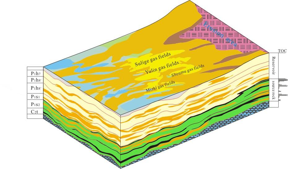
7 Fig. 5 Distribution of Upper Paleozoic slope structure and gas reservoir in Ordos Basin Fig. 6 Gas reservoir profile map of Sulige Gas field, Ordos Basin Ordos Basin is one of the significant cratonic basins in middle-west of China in Middle Paleozoic, where the Upper Paleozoic geomorphology and geology of middle slope part are characterized by: (1) large area: slope is about 260km wide from east to west and about 500km long from north to south, the area is up to130000km2, which occupies 46.4% of the whole basin area; (2) monotonous structural feature and gentle dip: the dip usually varies from 1 to 2, the maximum value is 3, and local structure is not developed. Under the stable and gentle structural setting, the highly-effective gas accumulation process is controlled by three favorable conditions: one is that coal series source rock is in large-area close contact with reservoir and presents the assemblage mode of lower-generation and 7
8
9 Ⅲ =~
10
11 ~ ~
12 (~)
13 ()
14
15 ~
16
17 ~,,,:~ ~,,.,,,:
18 ,, ():,,,,
Research of geological characteristics in Bashijiqike formation of Keshen-2 gas reservoir, Tarim basin, China
 Research of geological characteristics in Bashijiqike formation of Keshen-2 gas reservoir, Tarim basin, China Abstract: CHU Guangzhen Research Institute of Petroleum Exploration and Development - Langfang
Blocks 31, 32, 33, 34, 35 & 36/03 Southeast Offshore Vietnam
 Blocks 31, 32, 33, 34, 35 & 36/03 Southeast Offshore Vietnam Block 31 32 33 34 35 36/03 Area (km 2) 5,036 4,440 4,630 4,700 4,630 2,950 Sea level (m) 20 20-30 30-40 50 50 50 Seismic 2D (km) 1,294 685 431
BALOCHISTAN FOLDBELT BASIN
 INTRODUCTION BALOCHISTAN FOLDBELT BASIN The Kharan-3 block is located in the Kharan Trough of Balochistan Basin. GEOLOGICAL SETTING The Balochistan Province is an Upper Cretaceous to Recent structurally
Characteristics and accumulation mechanism of tight sandstone gas reservoirs in the Upper Paleozoic, northern Ordos Basin, China
 442 DOI 1.17/s12182-13-294-1 Characteristics and accumulation mechanism of tight sandstone gas reservoirs in the Upper Paleozoic, northern Ordos Basin, China Liu Guangdi 1 Shenghe 1, Sun Mingliang 1, Zhao
Petroleum geology framework, West Coast offshore region
 Petroleum geology framework, West Coast offshore region James W. Haggart* Geological Survey of Canada, Vancouver, BC jhaggart@nrcan.gc.ca James R. Dietrich Geological Survey of Canada, Calgary, AB and
EGAS. Ministry of Petroleum
 EGAS Ministry of Petroleum EGAS Ministry of Petroleum About The Block Location: N. Thekah offshore block is located at about 56 km to the north of the Mediterranean shore line, 85 km to the north west
Structural Geology of the Mountains
 Structural Geology of the Mountains Clinton R. Tippett Shell Canada Limited, Calgary, Alberta clinton.tippett@shell.ca INTRODUCTION The Southern Rocky Mountains of Canada (Figure 1) are made up of several
Gas Accumulation Condition Study of the Permian Taiyuan Formation in Linxing Gas Field, Ordos Basin
 Gas Accumulation Condition Study of the Permian Taiyuan Formation in Linxing Gas Field, Ordos Basin Abstract Peng Wu 1 School of Energy Resources, China University of Geosciences, Beijing 100083, China
Fluvial-Estuarine and Deltaic Reservoirs, Shelf Margin Delta and Slope Reservoir Characteristics Philip Sedore 2015
 Fluvial-Estuarine and Deltaic Reservoirs, Shelf Margin Delta and Slope Reservoir Characteristics Philip Sedore 2015 Introduction The offshore Columbus Basin and the onshore Southern Basin of Trinidad are
An analysis of the types and distribution characteristics of natural gas reservoirs in China
 38 DOI 10.1007/s12182-009-0007-y An analysis of the types and distribution characteristics of natural gas reservoirs in China Xu Zhangyou 1, 2, Yue Dali 1, 2, Wu Shenghe 1, 2, Zhang Xiaoyu 1, Chen Ce 1
Vail et al., 1977b. AAPG 1977 reprinted with permission of the AAPG whose permission is required for further use.
 Well 5 Well 4 Well 3 Well 2 Well 1 Vail et al., 1977b AAPG 1977 reprinted with permission of the AAPG whose permission is required for further use. Well 5 Well 4 Well 3 Well 2 Well 1 Vail et al., 1977b
Sequence Stratigraphy. Historical Perspective
 Sequence Stratigraphy Historical Perspective Sequence Stratigraphy Sequence Stratigraphy is the subdivision of sedimentary basin fills into genetic packages bounded by unconformities and their correlative
Mesozoic Earth History
 Mesozoic Earth History The Mesozoic Era 251-66 MYA Breakup of Pangea Changes in air and oceanic currents Evolution of new terrestrial and marine life Opening of the Atlantic Ocean Basin Rocky Mountains
Exploration Significance of Unconformity Structure on Subtle Pools. 1 Vertical structure characteristics of unconformity
 Exploration Significance of Unconformity Structure on Subtle Pools Wu Kongyou (China University of Petroleum,College of Geo-Resources and Information,Shandong Qingdao 266555) Abstract: Vertical structure
EGAS. Ministry of Petroleum
 EGAS Ministry of Petroleum EGAS Ministry of Petroleum About The Block Location: N. El Arish offshore block is located in the extreme eastern part of the Egypt s economic water border and bounded from the
Genetic types and distribution of shallow-buried natural gases
 Pet.Sci.(2010)7:347-354 DOI 10.1007/s12182-010-0076-y 347 Genetic types and distribution of shallow-buried natural gases Gao Yang 1, Jin Qiang 1 and Zhu Guangyou 2 1 College of Geo-resources and Information,
Stratigraphic Trap Identification Based on Restoration of Paleogeophology and Further Division of System Tract: A Case Study in Qingshui Subsag*
 Stratigraphic Trap Identification Based on Restoration of Paleogeophology and Further Division of System Tract: A Case Study in Qingshui Subsag* Cao Laisheng 1, Yu Lin 1, Liu Jianlun 1, Xiang Sheng 1,
Outline 16: The Mesozoic World: Formation of Oil Deposits (with a side trip to the Devonian Marcellus Shale)
") Outline 16: The Mesozoic World: Formation of Oil Deposits (with a side trip to the Devonian Marcellus Shale) The first commercial oil well was drilled by Colonel Edwin Drake in Titusville, Pennsylvania,
Outline 16: The Mesozoic World: Formation of Oil Deposits (with a side trip to the Devonian Marcellus Shale) The first commercial oil well was drilled by Colonel Edwin Drake in Titusville, Pennsylvania,
Perspectives from Offshore Argentina & Uruguay
 Perspectives from Offshore Argentina & Uruguay A Prospectivity Overview Hannah Kearns October 2018 Introduction Argentina Offshore License Round 1 14 blocks Argentina North, 24 Austral-Malvinas Offshore
Sedimentary Cycle Best Practice: Potential Eo-Oligocene Sediments in Western Indonesia*
 Sedimentary Cycle Best Practice: Potential Eo-Oligocene Sediments in Western Indonesia* Mellinda Arisandy 1 and I Wayan Darma 1 Search and Discovery Article #11008 (2017)** Posted November 6, 2017 *Adapted
Earth Science, (Tarbuck/Lutgens) Chapter 10: Mountain Building
 Chapter 10: Mountain Building") Earth Science, (Tarbuck/Lutgens) Chapter 10: Mountain Building 1) A(n) fault has little or no vertical movements of the two blocks. A) stick slip B) oblique slip C) strike slip D) dip slip 2) In a(n) fault,
Earth Science, (Tarbuck/Lutgens) Chapter 10: Mountain Building 1) A(n) fault has little or no vertical movements of the two blocks. A) stick slip B) oblique slip C) strike slip D) dip slip 2) In a(n) fault,
GEOLOGY GL1 Foundation Unit
 Candidate Name Centre Number Candidate Number 2 General Certificate of Education Advanced Subsidiary/Advanced 451/01 GEOLOGY GL1 Foundation Unit P.M. THURSDAY, 10 January 2008 (1 hour) Examiner Question
Hydrocarbon Geology Characteristics and Oil & Gas Resource Potential. Afghan-Tajik Basin. Wei Yin 1, a
 Advanced Materials Research Online: 2013-08-16 ISSN: 1662-8985, Vols. 734-737, pp 366-372 doi:10.4028/www.scientific.net/amr.734-737.366 2013 Trans Tech Publications, Switzerland Hydrocarbon Geology Characteristics
SHALE GAS IN CHINA:NEW IMPORTANT ROLE OF ENERGY IN 21 ST CENTURY
 922 SHALE GAS IN CHINA:NEW IMPORTANT ROLE OF ENERGY IN 21 ST CENTURY Liu Honglin, Wang Hongyan, Liu Renhe, Zhaoqun,Lin Yingji New energy Institute, RIPED-langfang, PetroChina Company Limited Post Box 44,
Potential Hydrocarbon Discoveries in Bjelovar Subdepression, Croatia By Tomislav Malvic 1 and Igor Rusan 2
 Potential Hydrocarbon Discoveries in Bjelovar Subdepression, Croatia By Tomislav Malvic 1 and Igor Rusan 2 Search and Discovery Article #10133 (2007) Posted September 25, 2007 1 INA-Industrija nafte, d.d.,
REGIONAL GEOLOGY IN KHMER BASIN
 CONTENTS 1-Khmere Basin 2-Regional Geology Khmer Basin 3-Regime Tectonic 4-Seismic Database -a/ Acquisition Data -b/ Prospect Angkor -C/ Cross Section Seismic 5-Play Type -a/ Play Schematic -b/ Structure
Case Study of the Structural and Depositional-Evolution Interpretation from Seismic Data*
 Case Study of the Structural and Depositional-Evolution Interpretation from Seismic Data* Yun Ling 1, Xiangyu Guo 1, Jixiang Lin 1, and Desheng Sun 1 Search and Discovery Article #20143 (2012) Posted April
Deformation of Rocks. Orientation of Deformed Rocks
 Deformation of Rocks Folds and faults are geologic structures caused by deformation. Structural geology is the study of the deformation of rocks and its effects. Fig. 7.1 Orientation of Deformed Rocks
Chapter 3. Geology & Tectonics
 Chapter 3 Geology & Tectonics 3.1 Geology The general geological features of Indonesia are shown in Figure 3.1. The basement formation is metamorphic and it is intruded with plutonic formations. They are
Strike-Slip Faults. ! Fault motion is parallel to the strike of the fault.
 Strike-Slip Faults! Fault motion is parallel to the strike of the fault.! Usually vertical, no hanging-wall/footwall blocks.! Classified by the relative sense of motion. " Right lateral opposite block
Continental Landscapes
 Continental Landscapes Landscape influenced by tectonics, climate & differential weathering Most landforms developed within the last 2 million years System moves toward an equilibrium Continental Landscapes
December 21, Chapter 11 mountain building E.notebook. Feb 19 8:19 AM. Feb 19 9:28 AM
 Mountains form along convergent plate boundaries. Typically (usually) if you look at a mountain range, you know that it is at a plate boundary (active continental margin) or has been some time in the past
GEOLOGIC MAPS PART II
 EARTH AND ENVIRONMENT THROUGH TIME LABORATORY - EES 1005 LABORATORY FIVE GEOLOGIC MAPS PART II Introduction Geologic maps of orogenic belts are much more complex than maps of the stable interior. Just
Cenozoic: Global Events Ma- Present
 Cenozoic: Global Events 65.5 Ma- Present Major Tectonic Events The Rise of the Himalayas and Closure of the Tethyan Ocean Caused Climate Change Equatorial Ocean Closed Rifting in Western North America
Orphan Basin, Offshore Newfoundland: New seismic data and hydrocarbon plays for a dormant Frontier Basin
 Orphan Basin, Offshore Newfoundland: New seismic data and hydrocarbon plays for a dormant Frontier Basin Jerry Smee* G&G Exploration Consulting, 301 400-3rd Avenue SW, Calgary, AB, T2P 4H2 Sam Nader, Paul
RELINQUISHMENT REPORT. License P1546 Block April 2009
 RELINQUISHMENT REPORT License P1546 Block 110-01 14 April 2009 Sherritt International Oil and Gas Limited 2000, 425-1 st street S.W., Calgary, Alberta Canada T2P 3L8 Telephone (403) 260-2900 Fax (403)
Geologic Trips San Francisco and the Bay Area
 Excerpt from Geologic Trips San Francisco and the Bay Area by Ted Konigsmark ISBN 0-9661316-4-9 GeoPress All rights reserved. No part of this book may be reproduced without written permission in writing,
The Lithosphere and the Tectonic System. The Structure of the Earth. Temperature 3000º ºC. Mantle
 The Lithosphere and the Tectonic System Objectives: Understand the structure of the planet Earth Review the geologic timescale as a point of reference for the history of the Earth Examine the major relief
Answers: Internal Processes and Structures (Isostasy)
") Answers: Internal Processes and Structures (Isostasy) 1. Analyse the adjustment of the crust to changes in loads associated with volcanism, mountain building, erosion, and glaciation by using the concept
Answers: Internal Processes and Structures (Isostasy) 1. Analyse the adjustment of the crust to changes in loads associated with volcanism, mountain building, erosion, and glaciation by using the concept
Abstract. Introduction. Regional Setting. GCSSEPM to be published December 2003
 Shelf Margin Deltas and Associated Deepwater Deposits: Implications on Reservoir Distribution and Hydrocarbon Entrapment, Block VI-1, Ulleung Basin, East Sea, South Korea Sneider, John S. Sneider Exploration,
Downloaded 01/06/15 to Redistribution subject to SEG license or copyright; see Terms of Use at
 Application of wide-azimuth 3D seismic attributes to predict the microfractures in Block MA area for shale gas exploration in South China Yusheng Zhang* 1, Gang Yu 1, Ximing Wang 1, Xing Liang 2, and Li
Ministry of Oil and Minerals Petroleum Exploration & Production Authority BLOCK 80 (WADI SARR)
") Ministry of Oil and Minerals Petroleum Exploration & Production Authority BLOCK 80 (WADI SARR) The Wadi Sarr Block (80) occupies an area of 1961 km 2 on the Sayun- Masilah Basin in the central Yemen. Block
Ministry of Oil and Minerals Petroleum Exploration & Production Authority BLOCK 80 (WADI SARR) The Wadi Sarr Block (80) occupies an area of 1961 km 2 on the Sayun- Masilah Basin in the central Yemen. Block
B.C. s Offshore Oil and Gas: a Guide to the Geology and Resources.
 B.C. s Offshore Oil and Gas: a Guide to the Geology and Resources. Introduction Beneath the offshore regions of British Columbia are four moderately large, geologically young sedimentary basins (Figure
ANGOLA OFFSHORE LICENSING 2007 BLOCK 46
 AGOLA OFFHOR LICIG 2007 BLOCK 46 DATA BA AVAILABILITY Figure 1 shows the seismic data available on Block 46. Fig. 1 Commercial 2D surveys: esterngeco: 794 km. GX Technology: 116 km. Commercial 3D surveys:
Copyright McGraw-Hill Education. All rights reserved. No reproduction or distribution without the prior written consent of McGraw-Hill Education
 Copyright McGraw-Hill Education. All rights reserved. No reproduction or distribution without the prior written consent of McGraw-Hill Education Tibetan Plateau and Himalaya -southern Asia 11.00.a VE 10X
Could the Himalaya be Self-Sufficient in Conventional and Unconventional Hydrocarbon Resources
 Could the Himalaya be Self-Sufficient in Conventional and Unconventional Hydrocarbon Resources Sustainable Resource Development in the Himalaya Leh, 24-26 June, 2014 Naveen Hakhoo Distribution of proved
PROCEEDINGS, INDONESIAN PETROLEUM ASSOCIATION Forty-First Annual Convention & Exhibition, May 2017
 IPA17-369-SG PROCEEDINGS, INDONESIAN PETROLEUM ASSOCIATION Forty-First Annual Convention & Exhibition, May 2017 FACIES ANALYSIS OF LATE NEOGENE DEPOSIT: MARINE TO CONTINENTAL ENVIRONMENT OF THE MERAPI
Controls on facies distributions in the Charlie Lake Formation, Peace River Arch, Alberta
 Controls on facies distributions in the Charlie Lake Formation, Peace River Arch, Alberta E.L. Percy 12, C. Frostad 2, A. Juska 2, C. Schmidt 2, C. Sitzler 2, and J.P. Zonneveld 3 University of Calgary,
Basin Analysis. Stra-graphy
 Basin Analysis Stra-graphy Basin Analysis Basin analysis integrates program sedimentological, stra-graphic, and tectonic principals to develop a full understanding of the rocks that fill sedimentary basins.
Overview of Indonesian Geothermal System
 Overview of Indonesian Geothermal System The Resources Beyond High Enthalpy Magmatic/Volcanic Systems By Dr.Eng. Suryantini ITB 4/3/2017 1 Outline Current Condition of Indonesian Geothermal Resources and
Hydrocarbon Potential of the Marginal Fields in Niger Delta Oza Field, a case study*
 Hydrocarbon Potential of the Marginal Fields in Niger Delta Oza Field, a case study* J.N. Sahu 1, C.H.V. Satya Sai 1, V. Chintamani 1 and C. Vishnu Vardhan 1 Search and Discovery Article #20182 (2012)*
Salt invasion in a Triassic reservoir. A case study from the Southern North Sea
 Salt invasion in a Triassic reservoir A case study from the Southern North Sea Agenda Regional setting Triassic gas play Statistical investigation Seismic attribute analysis Conclusions & further study
3. The diagram below shows how scientists think some of Earth's continents were joined together in the geologic past.
 1. The map below shows the present-day locations of South America and Africa. Remains of Mesosaurus, an extinct freshwater reptile, have been found in similarly aged bedrock formed from lake sediments
What is a sedimentary rock?
 Sedimentary Rocks What is a sedimentary rock? Sedimentary rocks are products of mechanical and chemical weathering They account for only 5% of the top 10 miles of the outer crust, yet most of the earth
A comparison of structural styles and prospectivity along the Atlantic margin from Senegal to Benin. Peter Conn*, Ian Deighton* & Dario Chisari*
 A comparison of structural styles and prospectivity along the Atlantic margin from Senegal to Benin Overview Peter Conn*, Ian Deighton* & Dario Chisari* * TGS, Millbank House, Surbiton, UK, KT6 6AP The
Section 7. Reading the Geologic History of Your Community. What Do You See? Think About It. Investigate. Learning Outcomes
 Chapter 3 Minerals, Rocks, and Structures Section 7 Reading the Geologic History of Your Community What Do You See? Learning Outcomes In this section, you will Goals Text Learning Outcomes In this section,
Jordan. Target Exploration. Target Exploration
 Page1 barr Target Exploration Target Exploration barr Target Exploration Target Exploration Petroleum Potential of Wadi Sirhan Basin Jordan Petroleum Potential of Wadi Sirhan Basin, Jordan Sequence Stratigraphy,
Geology 15 West Valley College. Exam IV: Sierra Nevada
 Geology 15 West Valley College Name Exam IV: Sierra Nevada 1) On the diagram above, where is the Arc- Trench Gap? a. 1 and 3 c. 7 and 8 d. 6 e. 5 and 10 2) On the diagram above, where is the subduction
MUHAMMAD S TAMANNAI, DOUGLAS WINSTONE, IAN DEIGHTON & PETER CONN, TGS Nopec Geological Products and Services, London, United Kingdom
 Geological and Geophysical Evaluation of Offshore Morondava Frontier Basin based on Satellite Gravity, Well and regional 2D Seismic Data Interpretation MUHAMMAD S TAMANNAI, DOUGLAS WINSTONE, IAN DEIGHTON
GEOLOGY MEDIA SUITE Chapter 5
 UNDERSTANDING EARTH, SIXTH EDITION GROTZINGER JORDAN GEOLOGY MEDIA SUITE Chapter 5 Sedimentation Rocks Formed by Surface Processes 2010 W.H. Freeman and Company Mineralogy of sandstones Key Figure 5.12
WP2 country review Lithuania
 Saulius Sliaupa Rasa Sliaupiene institute of Geology and Geography WP2 country review Lithuania CO 2 emission in Lithuania (2005) 94 sources listed in the CO2 trading system of Lithuania in 2005 CO 2 emissions
Structural Geology Lab. The Objectives are to gain experience
 Geology 2 Structural Geology Lab The Objectives are to gain experience 1. Drawing cross sections from information given on geologic maps. 2. Recognizing folds and naming their parts on stereoscopic air
The Late Tertiary Deep-Water Siliciclastic System of the Levant Margin - An Emerging Play Offshore Israel*
 The Late Tertiary Deep-Water Siliciclastic System of the Levant Margin - An Emerging Play Offshore Israel* Michael A. Gardosh 1, Yehezkel Druckman 2 and Binyamin Buchbinder 2 Search and Discovery Article
Sedimentary System Characteristics of Deng-3 Section on Paleo-central. Uplift Belt in Northern Songliao Basin. Siyang Li1,a*
 Sedimentary System Characteristics of Deng-3 Section on Paleo-central Uplift Belt in Northern Songliao Basin Siyang Li1,a* 1 School of Earth Sciences and Resources, China University of Geosciences, Beijing,
 Sedimentary Basin Analysis http://eqsun.geo.arizona.edu/geo5xx/geos517/ Sedimentary basins can be classified based on the type of plate motions (divergent, convergent), type of the lithosphere, distance
Blocks: 53/15b, 53/19, 53/20, 54/11 & 54/16. Promote Licence P1252 Two Year Report
 Blocks: 53/15b, 53/19, 53/20, 54/11 & 54/16 Promote Licence P1252 Two Year Report Wintershall Noordzee BV October 2006 Contents Contents 1 List of Figures and Tables...2 1. Licence details and work commitments...3
Structural Styles and Geotectonic Elements in Northwestern Mississippi: Interpreted from Gravity, Magnetic, and Proprietary 2D Seismic Data
 Structural Styles and Geotectonic Elements in Northwestern Mississippi: Interpreted from Gravity, Magnetic, and Proprietary 2D Seismic Data Nick Loundagin 1 and Gary L. Kinsland 2 1 6573 W. Euclid Pl.,
Geology (Mellow) Hike, Santa Lucia Memorial Park February 16, I. Overview of Santa Lucia Range geology and tectonic history
 Hike, Santa Lucia Memorial Park February 16, I. Overview of Santa Lucia Range geology and tectonic history") Geology (Mellow) Hike, Santa Lucia Memorial Park February 16, 2015 I. Overview of Santa Lucia Range geology and tectonic history A. Basement Rocks 1. Salinian Block Rocks Sierra Nevada Type, continental
Geology (Mellow) Hike, Santa Lucia Memorial Park February 16, 2015 I. Overview of Santa Lucia Range geology and tectonic history A. Basement Rocks 1. Salinian Block Rocks Sierra Nevada Type, continental
The Mesozoic. Wednesday, November 30, 11
 The Mesozoic Periods of the Mesozoic Triassic- First period of the Mesozoic era Jurassic Cretaceous- Last period of the Mesozoic era Breakup of Pangaea Stage one (Triassic) Rifting and volcanism, normal
Imprints of Mesozoic-Paleozoic strata and Eocene Carbonates in J&K Sub-Himalaya : Potential Rocks for Hydrocarbon Exploration
 6 th International Conference & Exposition on Petroleum Geophysics Kolkata 2006 Imprints of Mesozoic-Paleozoic strata and Eocene Carbonates in J&K Sub-Himalaya : Potential Rocks for Hydrocarbon Exploration
Oil and gas breakthroughs in ultra-deep Ordovician carbonate formations in Shuntuoguole uplift, Tarim Basin
 CHINA PETROLEUM EXPLORATION Volume 21, Issue 3, May 2016 Oil and gas breakthroughs in ultra-deep Ordovician carbonate formations in Shuntuoguole uplift, Tarim Basin Qi Lixin Sinopec Northwest Oilfield
Seismic stratigraphy, some examples from Indian Ocean, interpretation of reflection data in interactive mode
 Seismic stratigraphy, some examples from Indian Ocean, interpretation of reflection data in interactive mode K. S. Krishna National Institute of Oceanography, Dona Paula, Goa-403 004. krishna@nio.org Seismic
Future onshore hotspots
 Finding Petroleum Forum Global Hotspots Future onshore hotspots David Bamford & Ivan Sandrea This is only partly about the global search for shale oil and shale gas.. Our research suggests that estimated
Article. ZHAO WenZhi 1*, XU ChunChun 2, WANG TongShan 3*, WANG HongJun 3, WANG ZeCheng 3, BIAN CongSheng 3 & LI Xia 3. Geology
 Article Geology November 2011 Vol.56 No.31: 3310 3320 doi: 10.1007/s11434-011-4668-8 Comparative study of gas accumulations in the Permian Changxing reefs and Triassic Feixianguan oolitic reservoirs between
OIL INDIA LIMITED, GEOPHYSICS DEPARTMENT, DULIAJAN, ASSAM.
 J. P. Singh, M. K. Gupta & Akshaya Kumar, Oil India Limited, Duliajan. jpsingh@oilindia.in Summary Oil exploration in Upper Assam commenced with the discovery of the Digboi oilfield more than 100 years
COMPAGNIE MINIÈRE CONGOLAISE S.P.R.L. - CoMiCo
 COMPAGNIE MINIÈRE CONGOLAISE S.P.R.L. - CoMiCo assets in the Cuvette Centrale (Busira and Lokoro Sub-Basins) of the Democratic Republic of Congo March 2008 Prepared by HRT - HIGH RESOLUTION TECHNOLOGY
The McCully gas field in southern New Brunswick was discovered in the year 2000 on a joint drilling exploration venture by Corridor Resources Inc.
 1 The McCully gas field in southern New Brunswick was discovered in the year 2000 on a joint drilling exploration venture by Corridor Resources Inc. and Potash Corporation of Saskatchewan. Located about
Southern Songkhla Basin, Gulf of Thailand
 Architecture and Depositional Environment of Fluvial Systems of Southern Songkhla Basin, Gulf of Thailand Toan Manh Do Petroleum Geoscience Program, Department of Geology, Faculty of Science, Chulalongkorn
2.1. Central Indus Basin:
 14 2.1. Central Indus Basin: Research area lies in the Central Indus Basin of Pakistan. Central Indus Basin may be divided into following broad tectonic divisions from east to west (Kadri, 1995) (1) Punjab
Meandering Miocene Deep Sea Channel Systems Offshore Congo, West Africa
 Meandering Miocene Deep Sea Channel Systems Offshore Congo, West Africa S. Baer* (PGS), J. E. Comstock (PGS), K. Vrålstad (PGS), R. Borsato (PGS), M. Martin (PGS), J.P. Saba (SNPC), B. Débi-Obambé (SNPC)
Biostratigraphic and Lithostratigraphic Correlation of Sedimentary Strata in the Atlantic Coastal Plain
 Biostratigraphic and Lithostratigraphic Correlation of Sedimentary Strata in the Atlantic Coastal Plain Introduction to the Atlantic Coastal Plain (Please read this page prior to doing the lab) The Atlantic
Official languages: French and Arabic.
 Location: Chad is a landlocked Country located in the center of Africa, between 7 o and 23 o North Latitude, 13 o and 24 o East Longitude. Neighbour Country: Libya to the North; Central African Republic
History of Earth. Chapter 9: HISTORY OF EARTH. The Solar System. Early Earth: A Giant Impact! Early Earth. Formation of the Solar System
 Chapter 9: HISTORY OF EARTH The Essential Earth, 2 nd Edition Thomas H. Jordan & John Grotzinger History of Earth Earth is 4.56 Billion Years Old Earth has experienced a rich and diverse history that we
QUALITATIVE INTERPRETATION OF POTENTIAL FIELD PROFILES: SOUTHERN NECHAKO BASIN
 QUALITATIVE INTERPRETATION OF POTENTIAL FIELD PROFILES: SOUTHERN NECHAKO BASIN By Melvyn E. Best Bemex Consulting International 5288 Cordova Bay Road Victoria, B.C. V8Y 2L4 KEYWORDS: potential fields,
Plaattektoniek en Mickey Mouse: de bewegingen van de Aarde en de geologie van Marokko. G. Bertotti - TUDelft
 Plaattektoniek en Mickey Mouse: de bewegingen van de Aarde en de geologie van Marokko G. Bertotti - TUDelft Moving continents Continent with matching boundaries Same fauna in different continents Similar
Israel: Seeing Deeper Imaging new play concepts with Clari-Fi broadband reprocessing
 Israel: Seeing Deeper Imaging new play concepts with Clari-Fi broadband reprocessing Alex Birch-Hawkins Interpretation Geophysicist 12 th December 2016 Contents TGS in Israel Geological Overview Exploration
Genetic models of structural traps related to normal faults in the Putaohua Oilfield, Songliao Basin
 302 DOI 10.1007/s12182-008-0050-0 Genetic models of structural traps related to normal faults in the Putaohua Oilfield, Songliao Basin Sun Simin 1, Wu Xinsong 1, Liu Hongtao 2 and Wang Changsheng 2 1 School
Risk Factors in Reservoir Simulation
 Risk Factors in Reservoir Simulation Dr. Helmy Sayyouh Petroleum Engineering Cairo University 12/26/2017 1 Sources Of Data Petro-physical Data Water saturation may be estimated from log analysis, capillary
Tectonics and Hydrocarbon System, East Gobi Basin, Mongolia. Gary Prost, ConocoPhillips Canada, Calgary
 Tectonics and Hydrocarbon System, East Gobi Basin, Mongolia Gary Prost, ConocoPhillips Canada, Calgary Project Objectives (a joint project of Gulf Canada and ROC Oil) What structures can be expected in
Chapter 10: Deformation and Mountain Building. Fig. 10.1
 Chapter 10: Deformation and Mountain Building Fig. 10.1 OBJECTIVES Describe the processes of rock deformation and compare and contrast ductile and brittle behavior in rocks. Explain how strike and dip
Maturity Modeling of Gomin and South Gomin fields Southern Pattani Basin, Gulf of Thailand
 Maturity Modeling of Gomin and South Gomin fields Southern Pattani Basin, Gulf of Thailand Patinya Jaithan Petroleum Geoscience Program, Department of Geology, Faculty of Science, Chulalongkorn University,
Hydrocarbon potential and accumulation model in Chepaizi uplift, Junggar Basin
 CHINA PETROLEUM EXPLORATION Volume 21, Issue 3, May 2016 Hydrocarbon potential and accumulation model in Chepaizi uplift, Junggar Basin Song Mingshui 1, Lü Mingjiu 2, Zhao Leqiang 1, Sui Fenggui 1 1. Sinopec
5. Compare the density of the oceanic crust to continental crust. 6. What kind of plate boundary is this? convergent
 The youngest rock is in the middle (at ridge) and it gets older on either side as you move away in a symmetrical pattern. 1. How does the age of the seafloor compare on either side of the ridge? A = youngest
Tectonics is a study of the major structural features of the Earth s crust or a broad structure of a region. Tecto- means building
 TECTONICS AND TECTONIC STRUCTURES Tectonics is a study of the major structural features of the Earth s crust or a broad structure of a region. Tecto- means building The plate theory Different stages are
Characteristics of the Sedimentary Microfacies of Fuyu Reservoir in Yushulin Oilfield, Songliao Basin
 IOSR Journal of Engineering (IOSRJEN) ISSN (e): 2250-3021, ISSN (p): 2278-8719 Vol. 06, Issue 03 (March. 2016), V3 PP 01-05 www.iosrjen.org Characteristics of the Sedimentary Microfacies of Fuyu Reservoir
Exploration, Drilling & Production
 Nontechnical Guide to PETMOLEUM Geology, Exploration, Drilling & Production Third Edition Norman J. Hyne, Ph.D. Contents Preface *i Introduction 1 The Nature of Gas and Oil 1 Petroleum 1 The Chemistry
Chapter 4 Implications of paleoceanography and paleoclimate
 Age ka / Chapter 4 Implications of paleoceanography and paleoclimate 4.1 Paleoclimate expression 4.2 Implications of paleocirculation and tectonics 4.3 Paleoenvironmental reconstruction MD05-2901 (Liu
Effects of Tides on Deltaic Deposition: Causes and Responses*
 Effects of Tides on Deltaic Deposition: Causes and Responses* Piret Plink-Bjorklund 1 Search and Discovery Article #50626 (2012)** Posted June 25, 2012 *Adapted from oral presentation at AAPG Annual Convention
Determination of uplift rates of fluvial terraces across the Siwaliks Hills, Himalayas of central Nepal
 Determination of uplift rates of fluvial terraces across the Siwaliks Hills, Himalayas of central Nepal Martina Böhme Institute of Geology, University of Mining and Technology, Freiberg, Germany Abstract.
Effect Of The In-Situ Stress Field On Casing Failure *
 Effect Of The In-Situ Stress Field On Casing Failure * Tang Bo Southwest Petroleum Institute, People's Republic of China Lian Zhanghua Southwest Petroleum Institute, People's Republic of China Abstract