The Building of the NYC Region
|
|
|
- Annis Sullivan
- 5 years ago
- Views:
Transcription
1 The Building of the NYC Region
2 Definitions Fall Line marks the area where an upland region (continental bedrock) and a coastal plain meet Piedmont the plateau region of the eastern United States which lies between the coastal plain, from which it is divided by the fall line, and the eastern mountain ranges, the Appalachian Mountains Allochthonous A large block of rock moved from it s original location usually by a thrust fault Autochthonous a sediment or rock that can be found in situ at its site of formation or deposition

3 Subdivisions of physiographic provinces assigned to the NYC region Physiographic provinces are defined by contiguous physical geographic characteristics, such as flat sandy plains, mountainous areas, or rolling hills. Piedmont Fall Line

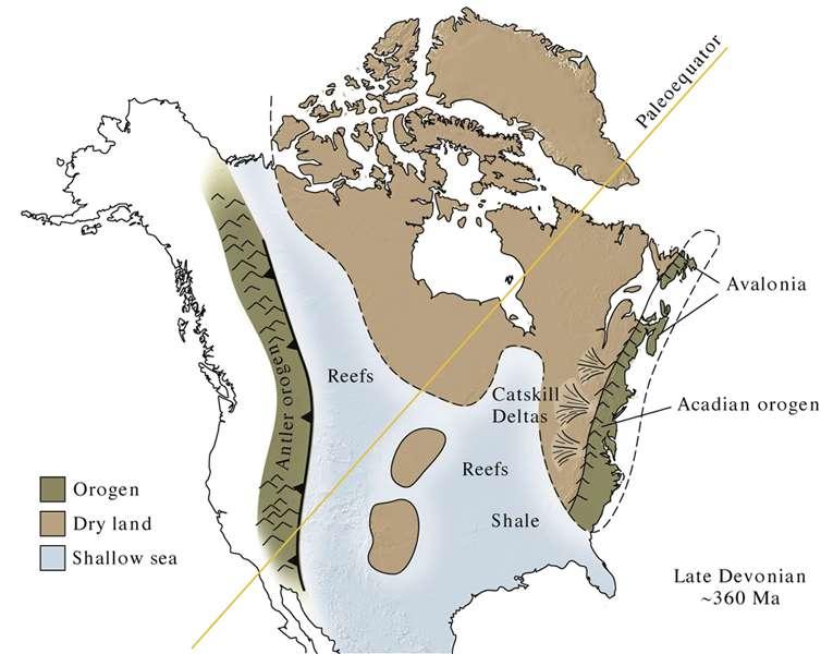
4 Map of continental arrangement at different times in the Phanerozoic
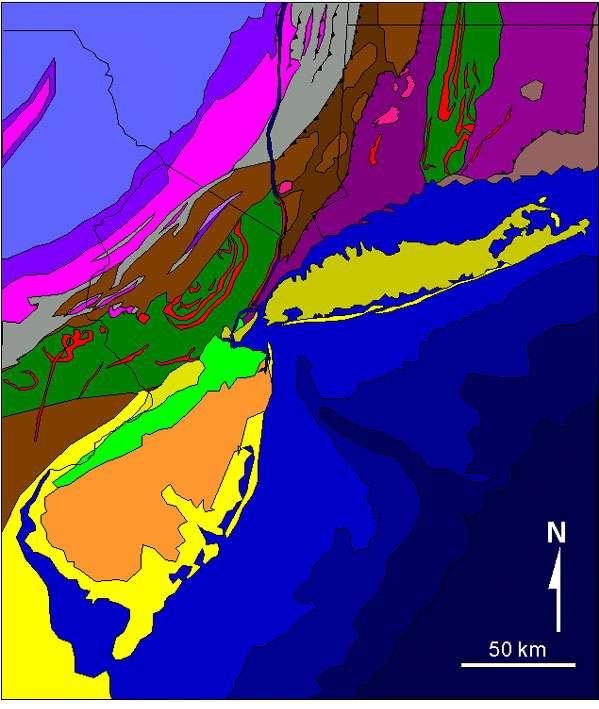
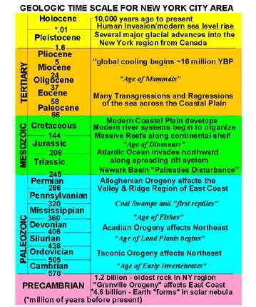
5 Generalized Geologic Map of NYC Region
6
7
8
, and ended roughly around 800")
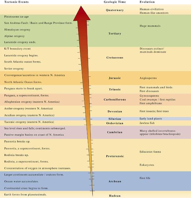
9 The Grenville Orogeny Began roughly 1.3 billion years ago (Middle Proterozoic), and ended roughly around 800 million years ago (Late Proterozoic)
10

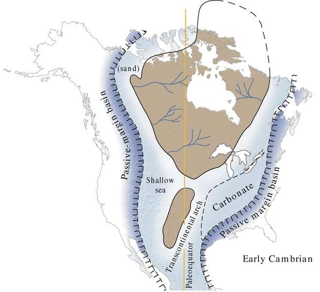
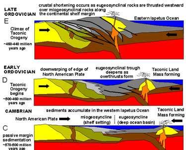
11 The Taconic Orogeny Ordovician mya Beginning in Cambrian time, about 550 million years ago, the Iapetus Ocean began to grow progressively narrower. about 440 million years ago Taconic Orogeny subsided in the New York Bight region during Late Ordovician time subduction ended culminating in the accretion of the Iapetus Terrane onto the eastern margin of the continent.
12 The Taconic Orogeny had the greatest overall effect on the geologic structure of basement rocks within the New York Bight region The effects are most apparent throughout New England, but the sediments derived from mountainous areas can be traced throughout the Applachians and midcontinental North America.
13
14
 Avalonia Volcanic island arc (J)")
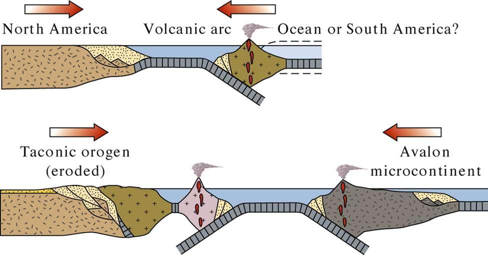
15 The Acadian Orogeny Avalonia Collides with Proto North America Devonian Period (408 to 360 million years ago) Avalonia Volcanic island arc (J) Gwandanaland
16
17
18 The Appalachian (Alleghenian) Orogeny Permian ~280 to 245 mya The geology of the Appalachians dates back to more than 480 million years ago the combined continents of Europe and Africa Gondwana collided with North America to form the supercontinent of Pangaea This collision exerted massive stress on what is today the Eastern Seaboard of North America, resulting in a large-scale uplift of the entire region Closer to the boundary between the colliding plates, tectonic stresses contributed to the metamorphosizing of the rock These stresses concurrently caused faults as well as folding.
19
20 The Appalachian Mountains At the peak of the mountain-building process the Appalachians could have risen as high or perhaps even higher than the present-day Himalaya Evidence The immense region involved in the continental collision the vast temporal length of the orogeny and the thickness of the pile of sediments and igneous rocks known to have been involved


21 Middle Appalachians. USGS Northeast Appalachians. USGS

22 Major fault at the dividing line between the Allegheny Plateau and the true Appalachian Mountains, Williamsport, Pennsylvania. The rock layers on the left are metamorphic while the rock layers on the right are sedimentary
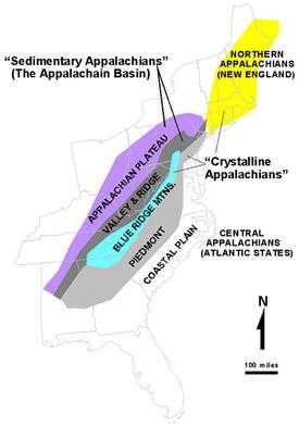
23 Subdivisions of the Appalachian Orogeny The Highlands Province - the ancient crystalline core of the Appalachian Mountains The Valley and Ridge Province - an extensive belt of folded sedimentary rocks extending from the Catskills region southwestward along the trend of the Appalachian Mountains.

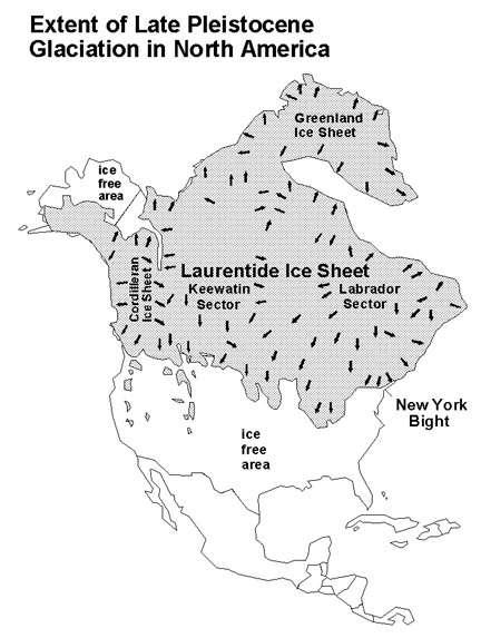
24 The Highlands Province
25 Subdivisions of the Appalachian Orogeny The Mesozoic Rift Basins include the Newark and Connecticut River Basins in the New York City region The Atlantic Coastal Plain refers to the subaerially exposed landward extension of the Atlantic Continental Shelf The continental shelf is transitional with the Baltimore Trough, a deep, thick, submarine sedimentary basin far offshore from the New York Bight area

26 Piedmont Valley and Ridge

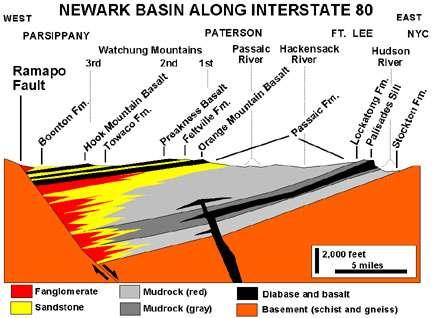
27 Newark Basin

28 The Palisades

29 Formed in multiple stages between about 192 to 186 million years ago (late Early Jurassic) The eroded cross-section of a large intrusive diabase sill Intruded between layers of sandstone and shale of the Late Triassic Stockton and Lockatong Formations in the Newark Basin Rises 600 feet above the Hudson The Palisades
30

31 Cenozoic Early Tertiary Many transgressions and regressions Miocene/Pliocene Global cooling begins Pleistocene Glacial advances
32

33 Map showing the location of the terminal moraine of the Wisconsin glacier (Stage 2) and the extent of morainedammed lakes in the New York City area (after Schubert, 1967).

34 Hypothetical map of the New York Bight during the maximum advance of the late Wisconsin glacier (Stage 2 - about 20,000 years BP).

35 Hypothetical map of the New York Bight during deposition of the Gardeners Clay in Early Holocene time (Stage 1 - about 8,000 year BP).

36 Pleistocene glacial deposits and features in the New York City region.
37 Ice Ages in the Bight For periods of time when sea level was lower, New York Harbor was probably a canyon for a very turbulent Hudson River when it wasn't buried by glaciers South of the terminal moraines of the great ice sheet meltwater carried gravel, sand, and silt away from the melting ice, and deposited it on a broad outwash plain Sea level fell each time the continental ice sheets grew, and rose when the ice melted. the ocean's surface elevation possibly dropped as much as 400 feet, causing regression to the outer fringes of the continental shelf.
38 Long Island s Glacial History Two terminal morainal ridges An older more southerly deposit is called the Ronkonkoma Moraine formed during the an early part of the Wisconsin Stage of the Pleistocene Epoch (Stage 4 - prior to about 55,000 years ago). forms most of the low rolling hills along an east-to-west transect generally on the south side of the LIE (Long Island Expressway).
39 Long Island s Glacial History The higher, younger, more northerly morainal ridge is called the Harbor Hill Moraine. represents the terminal moraine of the most recent advance of Wisconsin Stage glacier (Stage 2) reached its most southward advance about 18,000 years ago. This glacier probably completely melted in the New York City region in the range of 13,000 to 12,000 years ago.

 and unstratified (till) deposits")
40 Lignite in the Late Cretaceous Magothy Formation exposed at the base of the sea cliffs in Caumsett State Park. Note the large glacial erratics on the gravel beach. Caumsett State Park Stratified (outwash) and unstratified (till) deposits exposed in the sea cliffs along Long Island Sound in Caumsett State Park.

41 Present Day
3/5/05 Dr. Stewart 1
 I. Physiography of Appalachian Mountains A. Introduction 1. These mountains extend from NE Canada to Georgia 2. They are the remains of a deeply eroded, ancient mountain chain once larger than the Himalayans
Terrain Units PALEOGEOGRAPHY: LANDFORM CREATION. Present Geology of NYS. Detailed Geologic Map of NYS
 NYS TOPOGRAPHY Why so? PALEOGEOGRAPHY: LANDFORM CREATION Prof. Anthony Grande AFG 014 Present Geology of NYS Detailed Geologic Map of NYS Generalized Geology Detailed Geology Hot links to the fold out
PALEOGEOGRAPHY of NYS. Definitions GEOLOGIC PROCESSES. Faulting. Folding 9/6/2012. TOPOGRAPHIC RELIEF MAP of NYS GRADATIONAL TECTONIC
 TOPOGRAPHIC RELIEF MAP of NYS PALEOGEOGRAPHY of NYS Prof. Anthony Grande AFG 2012 Definitions GEOLOGIC PROCESSES Geography: study of people living on the surface of the earth. Geology: the scientific study
A TRIP THROUGH VIRGINIA GEOLOGY FROM AN ENGINEER S PERSPECTIVE
 A TRIP THROUGH VIRGINIA GEOLOGY FROM AN ENGINEER S PERSPECTIVE Bob Moss, PE Principal Engineer ECS Mid Atlantic, LLC The Engineer Parent WHY IS AN UNDERSTANDING OF LOCAL GEOLOGY IMPORTANT? It provides
TOPOGRAPHIC RELIEF MAP of NYS. LANDFORMS of NYS. Landforms. Creation of NYS Landforms 9/22/2011
 TOPOGRAPHIC RELIEF MAP of NYS LANDFORMS of NYS Prof. Anthony Grande AFG 2011 Landforms The basis of present-day landforms (surface features) is the bedrock geology that has been worked on by the forces
Copyright McGraw-Hill Education. All rights reserved. No reproduction or distribution without the prior written consent of McGraw-Hill Education
 Copyright McGraw-Hill Education. All rights reserved. No reproduction or distribution without the prior written consent of McGraw-Hill Education Tibetan Plateau and Himalaya -southern Asia 11.00.a VE 10X
The Mesozoic. Wednesday, November 30, 11
 The Mesozoic Periods of the Mesozoic Triassic- First period of the Mesozoic era Jurassic Cretaceous- Last period of the Mesozoic era Breakup of Pangaea Stage one (Triassic) Rifting and volcanism, normal
C) Trenton limestone
 Trenton limestone") 1. Base your answer to the following question on the Earth Science Reference Tables, the core section below, and your knowledge of Earth Science. The core section shows the subsurface bedrock geology for
1. Base your answer to the following question on the Earth Science Reference Tables, the core section below, and your knowledge of Earth Science. The core section shows the subsurface bedrock geology for
LANDFORMS of NYS. Landforms. Exercise 4 9/13/2012. TOPOGRAPHIC RELIEF MAP of NYS. Physiographic map of NYS and vicinity showing Surface Features
 TOPOGRAPHIC RELIEF MAP of NYS LANDFORMS of NYS Prof. Anthony Grande AFG 2012 Landforms REMINDER: The basis of present-day landforms (surface features) is the bedrock geology that has been worked on by
Name: Date: Period: Page 1
 Name: Date: Period: Base your answers to questions 1 through 4 on the three bedrock outcrops below and on your knowledge of Earth science. The outcrops, labeled I, II, and III, are located within 15 kilometers
Phanerozoic (last 0.54 by) Tectonics Climate Life
 Tectonics Climate Life") Phanerozoic (last 0.54 by) Tectonics Climate Life Tools for Locating Past Continent Positions Fossils depending on climate Alignment of geological features Geometrical fit of continental margins Similarity
Phanerozoic (last 0.54 by) Tectonics Climate Life Tools for Locating Past Continent Positions Fossils depending on climate Alignment of geological features Geometrical fit of continental margins Similarity
By Gil Brenner OLLI Geology Of New York State and NY City
 By Gil Brenner OLLI 2013 Geology Of New York State and NY City Before We Start-- It s All in the PLATES! Geology of New York State including NYC CA. Active Margin A Passive Geologic Margin Gil Brenner
The Lithosphere and the Tectonic System. The Structure of the Earth. Temperature 3000º ºC. Mantle
 The Lithosphere and the Tectonic System Objectives: Understand the structure of the planet Earth Review the geologic timescale as a point of reference for the history of the Earth Examine the major relief
Plate Tectonics GEOL 101 Lecture 22 How Are Mountains Built?
 Plate Tectonics GEOL 101 Lecture 22 How Are Mountains Built? The Grand Tetons, Wyoming First a Brief Review of Sea Floor Spreading Prop: Test 3 Invitations Break-Up of a Continent and Origin of an Ocean
PHYSIOGRAPHIC REGIONS OF THE LOWER 48 UNITED STATES
 PHYSIOGRAPHIC REGIONS OF THE LOWER 48 UNITED STATES LAURENTIAN UPLAND 1. Superior Upland ATLANTIC PLAIN 2. Continental Shelf (not on map) 3. Coastal Plain a. Embayed section b. Sea Island section c. Floridian
TIME. Does not give the. Places events in sequencee 1 st, 2 nd, 3 rd. Gives a. exact date of an event. event. Radioactive Dating.
 Geologic History TIME Places events in sequencee 1 st, 2 nd, 3 rd Does not give the exact date of an event Gives a date or time of an event Uses the Law of Superposition Radioactive Dating Youngest Law
Geologic History. Earth is very, very old
 Geologic History Earth is very, very old Earth s History The history of Earth and the ages of rocks can be investigated and understood by studying rocks and fossils. Evidence of ancient, often extinct
3. The diagram below shows how scientists think some of Earth's continents were joined together in the geologic past.
 1. The map below shows the present-day locations of South America and Africa. Remains of Mesosaurus, an extinct freshwater reptile, have been found in similarly aged bedrock formed from lake sediments
Module 10: Resources and Virginia Geology Topic 4 Content: Virginia Geology Notes
 Virginia is composed of a very diverse landscape that extends from the beaches and barrier islands all of the way to the highly elevated Appalachian Plateau. Geologists have discovered ancient shallow
C) use of nuclear power D) number of volcanic eruptions
 use of nuclear power D) number of volcanic eruptions") 3121-1 - Page 1 Name: 1) The graph below shows the change in carbon dioxide concentration in parts per million (ppm) in Earth's atmosphere from 1960 to 1990. The most likely cause of the overall change
3121-1 - Page 1 Name: 1) The graph below shows the change in carbon dioxide concentration in parts per million (ppm) in Earth's atmosphere from 1960 to 1990. The most likely cause of the overall change
Why is it called the "Inland Basins" Region?
 Learning Series: Rocks of the Southeastern U. S. The BIG Picture Why is it called the "Inland Basins" Region? Inland from the mountains, the Earth s crust was buckled (downwarped) into a series of depressions
Landscape. Review Note Cards
 Landscape Review Note Cards Last Ice Age Pleistocene Epoch that occurred about 22,000 Years ago Glacier A large, long lasting mass of ice which forms on land and moves downhill because of gravity. Continental
Evolution of Continents Chapter 20
 Evolution of Continents Chapter 20 Does not contain complete lecture notes. Mountain belts Orogenesis the processes that collectively produce a mountain belt Includes folding, thrust faulting, metamorphism,
Geology (Mellow) Hike, Santa Lucia Memorial Park February 16, I. Overview of Santa Lucia Range geology and tectonic history
 Hike, Santa Lucia Memorial Park February 16, I. Overview of Santa Lucia Range geology and tectonic history") Geology (Mellow) Hike, Santa Lucia Memorial Park February 16, 2015 I. Overview of Santa Lucia Range geology and tectonic history A. Basement Rocks 1. Salinian Block Rocks Sierra Nevada Type, continental
Geology (Mellow) Hike, Santa Lucia Memorial Park February 16, 2015 I. Overview of Santa Lucia Range geology and tectonic history A. Basement Rocks 1. Salinian Block Rocks Sierra Nevada Type, continental
Forces That Shape Earth. How do continents move? What forces can change rocks? How does plate motion affect the rock cycle?
 Forces That Shape Earth How do continents move? What forces can change rocks? How does plate motion affect the rock cycle? Plate Motion Mountain ranges are produced by plate tectonics. The theory of plate
discussion of North America s physical features, including its landforms and bodies of
 Chapter 7 Natural Environments of North America Chapter 7 focuses on the natural environments of North America. The chapter opens with a discussion of North America s physical features, including its landforms
Earth History Exam. The remains of an early dinosaur could be found at reference point A. A B. B C. C D. D. page 1
 Name: Date: 1. Base your answer(s) to the following question(s) on the Earth Science Reference Tables and your knowledge of Earth science. The accompanying cross section shows undisturbed sedimentary bedrock.
Geologic Trips San Francisco and the Bay Area
 Excerpt from Geologic Trips San Francisco and the Bay Area by Ted Konigsmark ISBN 0-9661316-4-9 GeoPress All rights reserved. No part of this book may be reproduced without written permission in writing,
Structural Geology of the Mountains
 Structural Geology of the Mountains Clinton R. Tippett Shell Canada Limited, Calgary, Alberta clinton.tippett@shell.ca INTRODUCTION The Southern Rocky Mountains of Canada (Figure 1) are made up of several
Continental Landscapes
 Continental Landscapes Landscape influenced by tectonics, climate & differential weathering Most landforms developed within the last 2 million years System moves toward an equilibrium Continental Landscapes
Mesozoic Earth History
 Mesozoic Earth History The Mesozoic Era 251-66 MYA Breakup of Pangea Changes in air and oceanic currents Evolution of new terrestrial and marine life Opening of the Atlantic Ocean Basin Rocky Mountains
Chapter 10. Early Paleozoic Events
 Chapter 10 Early Paleozoic Events The Phanerozoic Eon Consists of three eras (from oldest to youngest): Paleozoic = "ancient life" (542-251 m.y. ago) Mesozoic = "middle life" (251-65.5 m.y. ago) Cenozoic
Unit 5: Earth s History Practice Problems
 Name: Date: 1. Which bedrock would be most likely to contain fossils? A. Precambrian granite B. Cambrian shale C. Pleistocene basalt D. Middle-Proterozoic quartzite 6. Base your answer(s) to the following
4. The map below shows a meandering stream. Points A, B, C, and D represent locations along the stream bottom.
 1. Sediment is deposited as a river enters a lake because the A) velocity of the river decreases B) force of gravity decreases C) volume of water increases D) slope of the river increases 2. Which diagram
Earth Science Lesson Plan Quarter 3, Week 7, Day 1
 Earth Science Lesson Plan Quarter 3, Week 7, Day 1 Outcomes for Today Standard Focus: PREPARE 1. Background knowledge necessary for today s reading. Continental ice sheets increase the weight of the Earth
 Page 1 of 9 Name: Base your answer to the question on the diagram below. The arrows show the direction in which sediment is being transported along the shoreline. A barrier beach has formed, creating a
Name: Mid-Year Review #2 SAR
 Name: Mid-Year Review #2 SAR Base your answers to questions 1 through 3 on on the diagram below, which shows laboratory materials used for an investigation of the effects of sediment size on permeability,
Guided Notes Surface Processes. Erosion & Deposition By: Glaciers
 Guided Notes Surface Processes Erosion & Deposition By: Glaciers K. Coder 2015 26) How does moving ice erode and deposit sediments? Glaciers (Movement of Ice): a naturally formed mass of ice and snow that
Mesozoic rock formations in the NY region. The Geologic History of New York State. The Mesozoic. Mesozoic Rock Formations in the NY Region
 The eologic History of New York State The Mesozoic eologic Provinces NY Region Timescale and geologic provinces of NY-NJ Mesozoic Rock Formations in the NY Region Mesozoic rock formations in the NY region
Shape Earth. Plate Boundaries. Building. Building
 Chapter Introduction Lesson 1 Lesson 2 Lesson 3 Lesson 4 Chapter Wrap-Up Forces That Shape Earth Landforms at Plate Boundaries Mountain Building Continent Building How is Earth s surface shaped by plate
Plio-Pleistocene Geology
 UNIVERSITY OF SOUTH ALABAMA GY 112: Earth History Plio-Pleistocene Geology Instructor: Dr. Douglas W. Haywick Last Time A) Cenozoic Tectonics Western North American tectonic provinces Plateaus and canyons
Beneath our Feet: The 4 Layers of the Earty by Kelly Hashway
 Beneath our Feet: The 4 Layers of the Earty by Kelly Hashway The Earth is more than a giant ball made up of dirt, rocks, and minerals. The Earth may look like a giant ball from when looking at it from
Portion of the Grand Canyon
 Landscapes Packet 9 Your Name Group Members Score Minutes Standard 4 Key Idea 2 Performance Indicator 2.1 Use the concepts of density and heat energy to explain observations of weather patterns, seasonal
Earth Science, (Tarbuck/Lutgens) Chapter 10: Mountain Building
 Chapter 10: Mountain Building") Earth Science, (Tarbuck/Lutgens) Chapter 10: Mountain Building 1) A(n) fault has little or no vertical movements of the two blocks. A) stick slip B) oblique slip C) strike slip D) dip slip 2) In a(n) fault,
Earth Science, (Tarbuck/Lutgens) Chapter 10: Mountain Building 1) A(n) fault has little or no vertical movements of the two blocks. A) stick slip B) oblique slip C) strike slip D) dip slip 2) In a(n) fault,
LANDFORM REGIONS IN CANADA. Classroom Notes and Descriptions
 LANDFORM REGIONS IN CANADA Classroom Notes and Descriptions Landform Regions in Canada There are eight distinct landforms in Canada: Western Cordillera Region Interior Plains Canadian Shield Hudson Bay
The boulder was most likely moved to this location by A) glacial ice B) prevailing wind C) streamfiow D) volcanic action
 glacial ice B) prevailing wind C) streamfiow D) volcanic action") 1. Which rock material was most likely transported to its present location by a glacier? A) rounded sand grains found in a river delta B) rounded grains found in a sand dune C) residual soil found on a
1. Which rock material was most likely transported to its present location by a glacier? A) rounded sand grains found in a river delta B) rounded grains found in a sand dune C) residual soil found on a
Name Class Date. In the space provided, write the letter of the definition that best matches the term or phrase.
 Skills Worksheet Directed Reading Section: The Changing Continents 1. What is the result of slow movements of tectonic plates? RESHAPING EARTH S CRUST In the space provided, write the letter of the definition
Unit 6: Interpreting Earth s History
 Unit 6: Interpreting Earth s History How do we know that the Earth has changed over time? Regent s Earth Science Name: Topics Relative Dating Uniformitarianism Superposition Original Horizontality Igneous
Name. 4. The diagram below shows a soil profile formed in an area of granite bedrock. Four different soil horizons, A, B, C, and D, are shown.
 Name 1. In the cross section of the hill shown below, which rock units are probably most resistant to weathering? 4. The diagram below shows a soil profile formed in an area of granite bedrock. Four different
What type of land feature is located at Point A? A Cliff B Delta C Mountain D Valley
 1 What type of land feature is located at Point A? A Cliff B Delta C Mountain D Valley Alfred Wegener s theory of continental drift was 2 not accepted by scientists when the theory was first proposed.
L.O: HOW GEOLOGISTS SEQUENCE EVENTS IN EARTH'S GEOLOGIC HISTORY IF NOT OVERTURNED, OLDEST ON BOTTOM, YOUNGEST ON TOP
 L.O: HOW GEOLOGISTS SEQUENCE EVENTS IN EARTH'S GEOLOGIC HISTORY IF NOT OVERTURNED, OLDEST ON BOTTOM, YOUNGEST ON TOP 1. Unless a series of sedimentary rock layers has been overturned, the bottom rock layer
Which landscape best represents the shape of the valleys occupied by glaciers? A) B) C) D)
 B) C) D)") 1. Glaciers often form parallel scratches and grooves in bedrock because glaciers A) deposit sediment in unsorted piles B) deposit rounded sand in V-shaped valleys C) continually melt and refreeze D) drag
1. Glaciers often form parallel scratches and grooves in bedrock because glaciers A) deposit sediment in unsorted piles B) deposit rounded sand in V-shaped valleys C) continually melt and refreeze D) drag
Chapter 10: Deformation and Mountain Building. Fig. 10.1
 Chapter 10: Deformation and Mountain Building Fig. 10.1 OBJECTIVES Describe the processes of rock deformation and compare and contrast ductile and brittle behavior in rocks. Explain how strike and dip
USU 1360 TECTONICS / PROCESSES
 USU 1360 TECTONICS / PROCESSES Observe the world map and each enlargement Pacific Northwest Tibet South America Japan 03.00.a1 South Atlantic Arabian Peninsula Observe features near the Pacific Northwest
Rocks of the Northeastern US: a brief review
 of the Northeastern US: a brief review There is an amazing diversity of rocks exposed at the surface in the Northeast. The rocks record a 1 billion year history of colliding plates, inland oceans, deposition,
Quiz Nine (9:30-9:35 AM)
") Quiz Nine (9:30-9:35 AM) UNIVERSITY OF SOUTH ALAAMA GY 112: Earth History Lecture 25: Paleozoic 2: More Laurentia! Instructor: Dr. Douglas W. Haywick Last Time The Paleozoic of North America 1) Laurentian
Quiz Nine (9:30-9:35 AM) UNIVERSITY OF SOUTH ALAAMA GY 112: Earth History Lecture 25: Paleozoic 2: More Laurentia! Instructor: Dr. Douglas W. Haywick Last Time The Paleozoic of North America 1) Laurentian
Geologic Time. What have scientists learned about Earth s past by studying rocks and fossils?
 Name Geologic Time What have scientists learned about Earth s past by studying rocks and fossils? Before You Read Before you read the chapter, think about what you know about geologic time Record your
Glacial Deposition and Groundwater in Dutchess County
 Glacial Deposition and Groundwater in Dutchess County Name: Period: Thousands of years ago an enormous ice sheet blanketed the Hudson Valley in what was called the Wisconsinan Glaciation. The ice reshaped
deep within the planet. They are also shaped by conditions on the planet s surface. In
 Chapter 4 Landforms, Water, and Natural Resources Earth is home to many different types of landforms. These landforms are shaped by forces deep within the planet. They are also shaped by conditions on
Geology of the Batemans Bay region. Geological evolution. The Lachlan Orogen
 Australian Journal of Earth Sciences 1 The word orogen is derived from the ancient Greek language word for mountain building. The Lachlan Orogen The rocks exposed in the Batemans Bay are part of the geological
1. The timeline below represents time on Earth from the beginning of the Paleozoic Era Ato the present B.
 Name Roy G Biv 1. The timeline below represents time on Earth from the beginning of the Paleozoic Era Ato the present B. Which numbered position best represents the time when humans first appeared in the
The Geology of Sebago Lake State Park
 Maine Geologic Facts and Localities September, 2002 43 55 17.46 N, 70 34 13.07 W Text by Robert Johnston, Department of Agriculture, Conservation & Forestry 1 Map by Robert Johnston Introduction Sebago
NC Earth Science Essential Standards
 NC Earth Science Essential Standards EEn. 2.1 Explain how processes and forces affect the Lithosphere. EEn. 2.1.1 Explain how the rock cycle, plate tectonics, volcanoes, and earthquakes impact the Lithosphere.
GY 111 Lecture Notes Thrust Faults and the Appalachian Mountains
 GY 111 Lecture Notes D. Haywick (2007-08) 1 Lecture Goals: A) Thrust Faults B) The Appalachian Mountains GY 111 Lecture Notes Thrust Faults and the Appalachian Mountains Reference: Press et al., 2004,
Potential short answer questions: What is Pangea? Describe at least 4 pieces of evidence that led Wegener to suggest the theory of Continental Drift.
 6th Grade Earth Science Fall Semester Mid-Term Study Guide The mid-term may include: 4 short answer questions,1-2 sketches to draw and/or label, 4 partially filled charts which you should complete, 30
I. Earth s Layers a. Crust: Earth s outside layer. Made of mostly rock. i. Continental: er; made of mostly granite, forms the continents and shallow
 I. Earth s Layers a. Crust: Earth s outside layer. Made of mostly rock. i. Continental: er; made of mostly granite, forms the continents and shallow sea beds, floats! ii. Oceanic: er; dense rock such as
Practice 3rd Quarter Exam Page 1
 Name 1. Which characteristic would most likely remain constant when a limestone cobble is subjected to extensive abrasion? A) shape B) mass C) volume D) composition 2. Which activity demonstrates chemical
Cenozoic: Global Events Ma- Present
 Cenozoic: Global Events 65.5 Ma- Present Major Tectonic Events The Rise of the Himalayas and Closure of the Tethyan Ocean Caused Climate Change Equatorial Ocean Closed Rifting in Western North America
Section 2: How Mountains Form
 Section 2: How Mountains Form Preview Objectives Mountain Ranges and Systems Plate Tectonics and Mountains Types of Mountains Objectives Identify the types of plate collisions that form mountains. Identify
Answers: Internal Processes and Structures (Isostasy)
") Answers: Internal Processes and Structures (Isostasy) 1. Analyse the adjustment of the crust to changes in loads associated with volcanism, mountain building, erosion, and glaciation by using the concept
Answers: Internal Processes and Structures (Isostasy) 1. Analyse the adjustment of the crust to changes in loads associated with volcanism, mountain building, erosion, and glaciation by using the concept
1.4 Notes: Plates Converge or Scrape Past Each Other Think About Tectonic Plates Push Together at Convergent Boundaries
 1.4 Notes: Plates Converge or Scrape Past Each Other Think About If new crust is created at divergent boundaries, why does the total amount of crust on Earth stay the same? Tectonic Plates Push Together
Lithospheric plates. Geology of the Batemans Bay region. Tectonic processes
 1 Lithospheric plates Enormous heat sources in the Earth s deep interior, acquired during the very early history of the planet billions of years ago continue to drive present-day geological at the surface.
Introduction to Prospecting. Session Two Geology
 Introduction to Prospecting Session Two Geology The Earth Earth is 4.6 billion years old (Ba). Bacteria & algae +3.5 Ba. Microscopic animals ~2 Ba. Animals ~600 million years (Ma) old. Mankind about 100,000
Fossils, Geologic Time, Absolute & Relative Dating, and Natural Resources. Chapters 5 & 6
 Fossils, Geologic Time, Absolute & Relative Dating, and Natural Resources Chapters 5 & 6 How Do Fossils Form? Fossils are found in sedimentary rocks like sandstone, limestone, and shale In Virginia, most
Resume components. Assignments due Monday. Shape of Puget Sound. Formation and bathymetry
 Assignments due Monday Resume Top four choices of projects, in order of preference One paragraph proposal about topic of choice Weekly schedule Topics you d like to cover in class Math: Complete the calculus
Cenozoic Earth History I
 Cenozoic Earth History I Cenozoic plate tectonics Tertiary, Quaternary, Paleogene, Neogene Tejas Transgression North America s east coast geology Laramide Orogeny Post-Laramide mountain building and volcanism
Directed Reading. Section: How Mountains Form MOUNTAIN RANGES AND SYSTEMS. Skills Worksheet
 Skills Worksheet Directed Reading Section: How Mountains Form 1. How high is Mount Everest? a. about 1980 km above sea level b. more than 8 km below sea level c. more than 8 km above sea level d. more
Earth Science. Name Block. Unit 3 Review Worksheet. Circle the letter that corresponds to the correct answer
 Earth Science Unit 3 Review Worksheet Name Block Circle the letter that corresponds to the correct answer 1. Which geologic principle is used when a geologist observes an outcrop or rocks and determines
Mountain Building. Mountain Building
 Mountain Building Mountain building has occurred during the recent geologic past American Cordillera the western margin of the Americas from Cape Horn to Alaska Includes the Andes and Rocky Mountains Alpine
Deformation of Rocks. Orientation of Deformed Rocks
 Deformation of Rocks Folds and faults are geologic structures caused by deformation. Structural geology is the study of the deformation of rocks and its effects. Fig. 7.1 Orientation of Deformed Rocks
Mesozoic Earth History Million years ago Triassic Jurassic Cretaceous
 Mesozoic Earth History 245-65 Million years ago Triassic Jurassic Cretaceous Geologic Time Scale www.geo.ucalgary.ca/~macrae/timescale/time_scale.gif Main Happenings in Mesozoic Breakup of Pangaea Lots
Chapter Two. Figure 02_02. Geography of the Ocean Basins. The Sea Floor
 Chapter Two The Sea Floor Geography of the Ocean Basins Figure 02_02 The world ocean is the predominant feature on the Earth in total area. In the Northern Hemisphere, 61% of the total area is ocean. In
Review participation point: The evidence for a fluid outer core is:
 DDA1 Continental Drift to Plate Tectonics PS 100 Chapter 28 Review participation point: The evidence for a fluid outer core is: A. Average density of the earth is greater than the density of the crust.
Refer to the map on page 173 to answer the following questions.
 Chapter 8-1 Plate Tectonics 1. Brainstorm the type of evidence that would indicate a climate change and how this evidence supports the theory of continental drift. Tropical fossils in cold regions Evidence
Landforms in Canada. Canada is made up of three dis;nct types of landforms: Canadian Shield Highlands Lowlands
 Canada s Landforms What is a Landform? A landform is any physical feature of the Earth s surface having a characteris;c, recognizable shape, produced by natural causes. Landforms include major features
Today we will discuss places mobility Natural disasters lead to California s beauty Aesthenosphere
 Agenda 2. Geologic History Today we will discuss What Physical Geography is Brief geologic history of California Geography 106 California Geography M. Pesses Antelope Valley College Physical Geographers
There are numerous seams on the surface of the Earth
 Plate Tectonics and Continental Drift There are numerous seams on the surface of the Earth Questions and Topics 1. What are the theories of Plate Tectonics and Continental Drift? 2. What is the evidence
Plate Tectonic Vocabulary Chapter 10 Pages
 Name: Period: Plate Tectonic Vocabulary Chapter 10 Pages 239-260 Vocabulary Word What is this? What are some examples? What does it look like? (draw a picture or diagram) Continental drift Mid-ocean ridge
Earth s Continents and Seafloors. GEOL100 Physical Geology Ray Rector - Instructor
 Earth s Continents and Seafloors GEOL100 Physical Geology Ray Rector - Instructor OCEAN BASINS and CONTINENTAL PLATFORMS Key Concepts I. Earth s rocky surface covered by of two types of crust Dense, thin,
Do Now: Vocabulary: Objectives. Vocabulary: 1/5/2016. Wegener? (Can they move?) the idea that continents have moved over time?
 the idea that continents have moved over time?") Do Now: 1. Who was Alfred Wegener? 2. What was Pangaea? 3. Are continents fixed? (Can they move?) 4. What evidence supports the idea that continents have moved over time? Objectives What evidence suggests
Do Now: 1. Who was Alfred Wegener? 2. What was Pangaea? 3. Are continents fixed? (Can they move?) 4. What evidence supports the idea that continents have moved over time? Objectives What evidence suggests
Plate Tectonics: A Unifying Theory
 Plate Tectonics: A Unifying Theory What is Plate Tectonics? - 7 large tectonic plates and many smaller ones that break up the lithosphere - Plates are brittle and float on asthenosphere and glide past
PROMISED LAND STATE PARK PIKE COUNTY ANCIENT RIVERS AND AGES OF ICE
 PENNSYLVANIA TRAIL OF GEOLOGY PARK GUIDE 18 PROMISED LAND STATE PARK PIKE COUNTY ANCIENT RIVERS AND AGES OF ICE Promised Land State Park is located on a broad upland surface known as the Pocono Plateau.
In the space provided, write the letter of the definition that best matches the term or phrase.
 Skills Worksheet Directed Reading Section: The Changing Continents 1. What is the result of slow movements of tectonic plates? RESHAPING EARTH S CRUST In the space provided, write the letter of the definition
Geologic History A B1
 Geologic History A B1 1. A whalebone that originally contained 200 grams of radioactive carbon-14 now contains 25 grams of carbon- 14. How many carbon-14 half-lives have passed since this whale was alive?
Earth s Layers. Earth s Surface
 CHAPTER 1 LESSON 3 Earth s Layers Earth s Surface Key Concepts What are Earth s major landforms and how do they compare? What are the major landform regions of the United States? What do you think? Read
Ocean Basins, Bathymetry and Sea Levels
 Ocean Basins, Bathymetry and Sea Levels Chapter 4 Please read chapter 5: sediments for next class and start chapter 6 on seawater for Thursday Basic concepts in Chapter 4 Bathymetry the measurement of
Directed Reading. Section: Continental Drift. years ago? WEGENER S HYPOTHESIS
 Skills Worksheet Directed Reading Section: Continental Drift 1. Who obtained new information about the continents and their coastlines 400 years ago? 2. What did people notice when they studied new world
Chapter 5: Glaciers and Deserts
 I. Glaciers and Glaciation Chapter 5: Glaciers and Deserts A. A thick mass of ice that forms over land from the compaction and recrystallization of snow and shows evidence of past or present flow B. Types
Exploring Geography. Chapter 1
 Exploring Geography Chapter 1 The Study of Geography Geography is the study of where people, places, and things are located and how they relate to each other. Greek meaning writing about or describing
Geologic History of Texas: The Making of Texas Over 1.5 Billion Years
 # 4 Geologic History of Texas: The Making of Texas Over 1.5 Billion Years Dr. Richard Kyle March 24, 2000 Produced by and for Hot Science - Cool Talks by the Environmental Science Institute. We request