Geologic Structures. Changes in the shape and/or orientation of rocks in response to applied stress
|
|
|
- Giles Colin Griffith
- 5 years ago
- Views:
Transcription
1

2 Geologic Structures Changes in the shape and/or orientation of rocks in response to applied stress

3 Figure Can be as big as a breadbox
4 Or much bigger than a breadbox
5 Three basic types Fractures >>> The rocks break but don t move Faults Folds >>> The rocks and move >>> Rocks don t break, but deform ductiley
6 What forces are involved?
7 Stress and Strain Stress is force per unit area The three basic types of stress are compressive, tensional and shear Strain is a change in size or shape in response to stress Geologic structures are indicative of the type of stress and its rate of application, as well the physical properties of the rocks or sediments
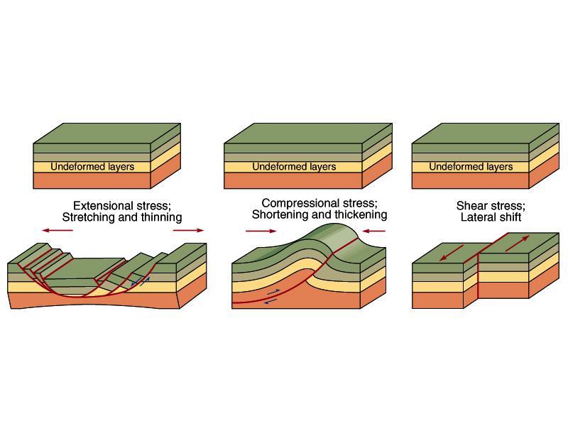
8 Rock Deformation Stress is the pressure or force applied to rocks that cause deformation to occur Uniform (confining) stress is equal in all directions (hydrostatic) Rocks are confined by the rock around them Differential stress is not equal in all directions (directional) This is what deforms rocks
9 Rock Deformation Three types of differential stress Tensional - pulling apart Compressional - squeezing together Shear - slipping, twisting, or wrenching Strain is the result of applying a stress to a rock The change in size and/or shape of a solid

10 Tension and compression

11 Shear stress
12 Rock Deformation Strain produces a spectrum of deformation Elastic deformation Rocks return to original shape Ductile deformation Irreversible change in size and/or shape Volume and density may change Brittle deformation - Fracture Stress exceeds the ductile limit Irreversible break

13 How Rocks Respond to Stress Rocks behave as elastic, ductile or brittle materials depending on: amount and rate of stress application type of rock temperature and pressure If deformed materials return to original shape after stress removal, they are behaving elastically However, once the stress exceeds the elastic limit of a rock, it deforms permanently ductile deformation involves bending plastically brittle deformation involves fracturing

14

15 Orientation of Geologic Structures Geologic structures are most obvious in deformed sedimentary rocks Tilted beds, joints, and faults are planar features whose orientation is described by their strike and dip Strike is the compass direction of a line formed by the intersection of an inclined plane with a horizontal plane Dip is the direction and angle from horizontal in which a plane is oriented
16 How do we describe rock relationships in nature?
17
18 Geometry of Rock Structures Structures may be defined by the orientation of planes Dip the angle of inclination downward from a horizontal plane Strike the compass bearing of a horizontal line where the inclined plane intersects an imaginary horizontal plane

19 Figure 15.7

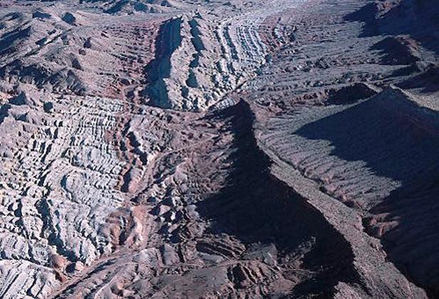
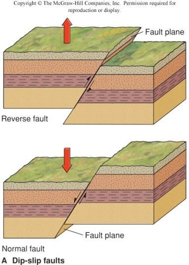
20 Fig Strike & Dip
21 Structures and Geologic Maps Rock structures are determined on the ground by geologists observing rock outcrops Outcrops are places where bedrock is exposed at the surface Geologic maps use standardized symbols and patterns to represent rock types and geologic structures, such as tilted beds, joints, faults and folds

22 Figure 15.8
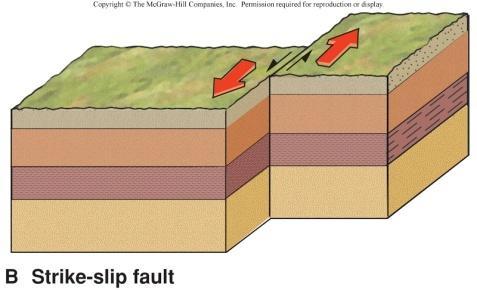
23 Figure 15.9
24 Geologic Structures: Fractures and Faults
25 Joints Fractures created by tension in brittle rocks No shear or displacement has occurred Form as overburden is removed, confining stress reduced Form by cooling of igneous rocks Often occur in sets

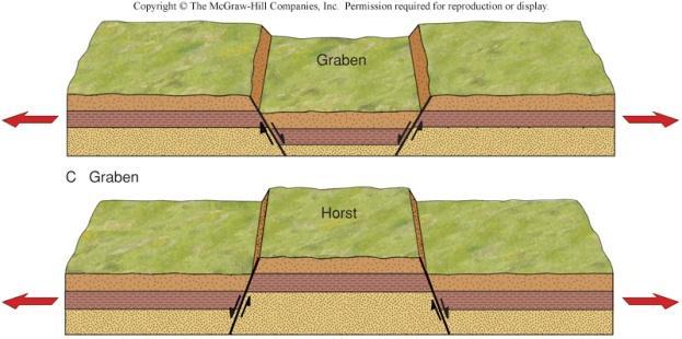
26 Joint systems
27 Faults Fractures that have been displaced Most faults are inclined at some angle measured from horizontal The dip angle of the fault Two blocks are defined, one on either side of the fault
28 Faults Fault geometry Imagine a horizontal tunnel cutting through a fault in cross-section Horizontal Surface Dip angle Hanging Wall Foot Wall Fault plane
29 Fault Types Faults may be divided into three categories Normal faults Hanging wall moves down relative to foot wall Block slides down the dip angle Reverse faults Hanging wall moves up relative to foot wall Block moves in the reverse direction to what seems normal
30 Fault Types Strike slip faults Displacement to sideways in a horizontal direction Movement is parallel to the strike of the fault plane Strike is the direction of the line formed by the intersection of the fault plane with the Earth s surface

31 Major types of faults

32
33 Normal Faults Normal faults are created by tensional forces, i.e. pulling apart Rifts are created by parallel normal faults dipping toward each other The block in the center which drops down is a graben The Rio Grande valley in New Mexico is a rift graben

34 A normal fault?
35 A special type of normal fault Fault blocks, bounded by normal faults, that drop down or are uplifted are known as grabens and horsts, respectively Grabens associated with divergent plate boundaries are called rifts
36

37 Normal faults produce grabens & horsts
38 Extensional (Normal) Faults reviewed
39 Reverse Faults Compressional stress usually causes reverse faults to form Reverse faults are common at convergent plate boundaries Reverse faults cause a thickening of the crust as rocks are piled up Older rocks may be found above younger rocks
40 Reverse Faults Thrust faults are a special kind of reverse fault Shallow dip angle, > 45 o Common in large mountain ranges Horizontal displacement may be many tens of kilometers Evidence of thrust faults in sedimentary rocks is seen when a sequence of the same rocks are repeated
41
42
43 Strike-Slip Faults Strike-Slip faults Principle movement is horizontal Left or Right Lateral Little or no vertical movement Caused by shear stress Indicated by abrupt changes in drainage patterns
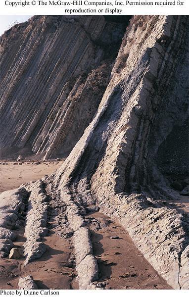
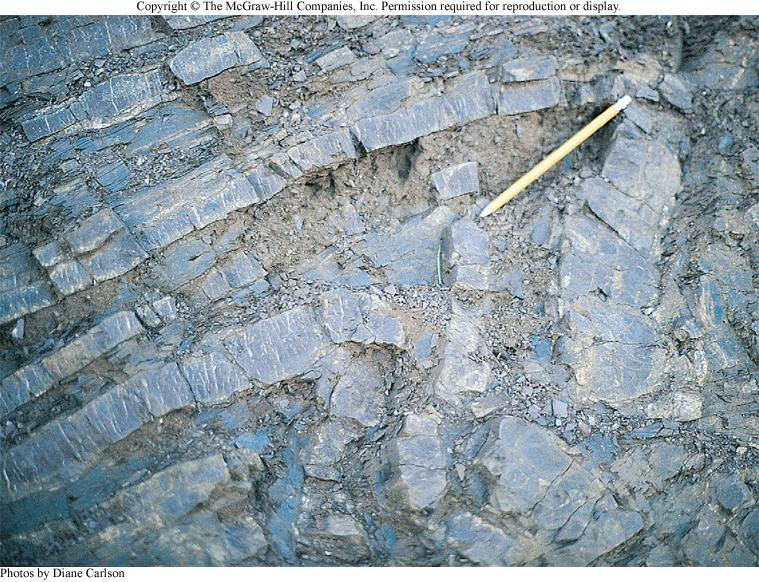
44

45 Strike-slip faults offset drainage


46 Types of Faults Strike-slip faults have movement that is predominantly horizontal and parallel to the strike of the fault plane A viewer looking across to the other side of a right-lateral strike-slip fault would observe it to be offset to their right A viewer looking across to the other side of a left-lateral strike-slip fault would observe it to be offset to their left Oblique-slip faults have movement with both vertical and horizontal components Right-lateral San Andreas Fault
47
48 F aulitng.exe
49 Movement Along Faults Rarely exceeds a few meters in a single event Small movements, cm scale, may occur on a regular basis Tectonic creep Total displacement may be km, but does not occur in a single event
50 Geologic Structures: Folds
 of the fold Anticlines are upward-arching folds, and synclines are downward-arching")
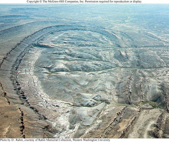
51 Folds Folds are wavelike bends in layered rock Represent rock strained in a ductile manner, usually under compression The axial plane divides a fold into its two limbs The surface trace of an axial plane is called the hinge line (or axis) of the fold Anticlines are upward-arching folds, and synclines are downward-arching folds
52 Folds Warps in rock strata due to ductile deformation 3-D structures of wide ranging scale Generally indicate horizontal compression Multiple generations of folding may exist
53 Folds Three simple fold forms exist Synclines warp downward Anticlines warp upward Monoclines dip in one direction
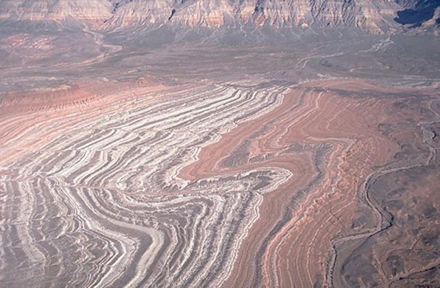
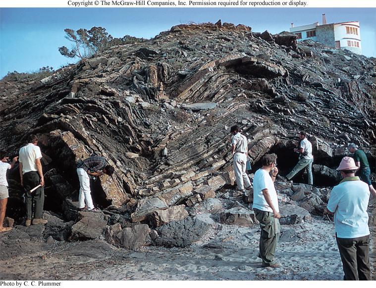
54 Folds Folds are described by: The strike of their hinge line The hinge line is the intersection of the hinge plane with the folded layer Hinge lines may be inclined in a plunging fold The angle of dip of their limbs

55 Fold geometry

56 Types of folds
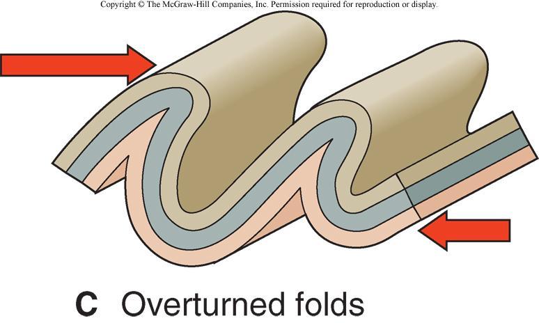
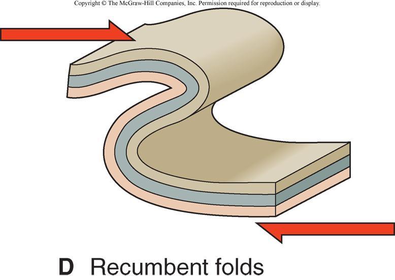
57 Anticlines & Synclines The sequence of ages of strata indicate the geologic structure in folds Anticlines have the oldest layers exposed at the center of the fold along the axial plane Synclines have the youngest strata exposed at the center along the axial plane
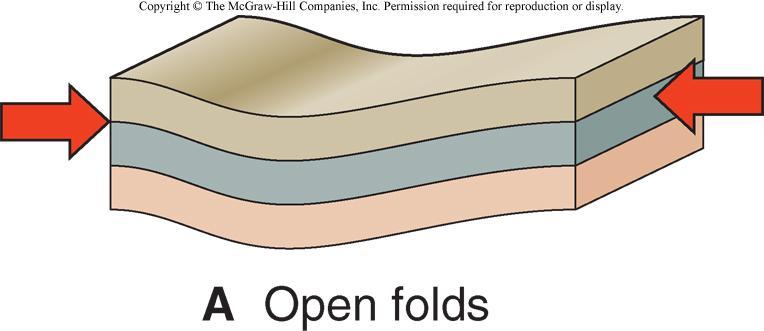
58
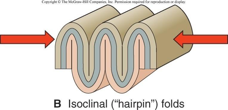
59 A series of anticlines & synclines
60
61
62 Fold Belts Orogenic belts consist of long linear series of folds Fold geometry is not overly complex Pattern of outcrops may appear complex Complex folds may develop as folds are: Re-folded Cut by thrust faults

63 Orogenic belt with complex folding
64 Complex Folds Folds may be very complex Application of shear stress Multiple folding events Complex forms are created
65 Complex Folds Plunging folds occur when the folds axis is dipping or plunging Limbs of Asymmetrical folds are not the same, one dips more steeply than the other Overturned and Recumbent folds occur when folding is so extreme that beds are turned upside-down
66 A plunging anticline


 Open folds have limbs that")


67 Types of Folds Plunging folds are folds in which the hinge line is not horizontal Where surfaces have been leveled by erosion, plunging folds form V- or horseshoe-shaped patterns of exposed rock layers (beds) Open folds have limbs that dip gently, whereas isoclinal folds have parallel limbs Overturned folds have limbs that dip in the same directions, and recumbent folds are overturned to the point of being horizontal
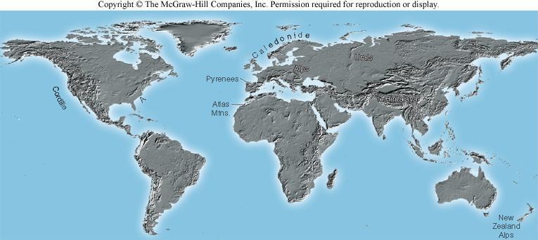
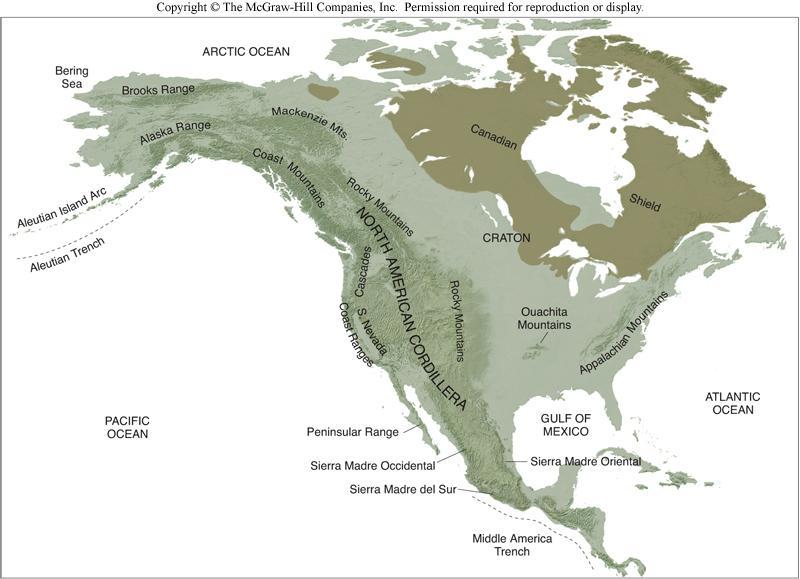
68
69 Folds.exe
70 Structural Domes and Basins Domes are structures in which the beds dip away from a central point Sometimes called doubly plunging anticlines Basins are structures in which the beds dip toward a central point Sometimes called doubly plunging synclines
71 Domes & Basins Complex Folds Generally occur in continental interiors Broadly warped regions Roughly circular pattern of outcrops
72

73 A small dome

74 Box 15.1 Figure 1a
75 Complex Folds Diapirs Less dense salt layers may rise up Some overlying strata may be pierced Salt diapir has an inverted teardrop shape Strata above diapir are domed upward

 increase Air (atmosphere) rising over mountain ranges results in precipitation and")
76 Mountain Belts and Earth s Systems Mountain belts are chains of mountain ranges that are 1000s of km long Commonly located at or near the edges of continental landmasses Mountain belts are part of the geosphere Form and grow by tectonic and volcanic processes over tens of millions of years As mountains grow higher and steeper, erosion rates (particularly from running water and ice - hydrosphere) increase Air (atmosphere) rising over mountain ranges results in precipitation and erosion


 of the continents Shields - areas of cratons laid bare by erosion Insert")
77 Characteristics of Mountain Belts Mountain belts are very long compared to their width The North American Cordillera runs from southwestern Alaska down to Panama Older mountain ranges (Appalachians) tend to be lower than younger ones (Himalayas) due to erosion Young mountain belts are tens of millions of years old, whereas older ones may be hundreds of millions of years old Ancient mountain belts (billions of years old) have eroded nearly flat to form the stable cores (cratons) of the continents Shields - areas of cratons laid bare by erosion Insert revised Fig h
78
79

")

80 Rock Patterns in Mountain Belts Mountain belts typically contain thick sequences of folded and faulted sedimentary rocks, often of marine origin May also contain great thicknesses of volcanic rock Fold and thrust belts (composed of many folds and reverse faults) indicate crustal shortening (and thickening) produced by compression Common at convergent boundaries Typically contain large amounts of metamorphic rock
81
82
83
84
85
86
87
88
89 Rock Patterns in Mountain Belts Erosion-resistant batholiths may be left behind as mountain ranges after long periods of erosion Localized tension in uplifting mountain belts can result in normal faulting Horsts and grabens can produce mountains and valleys Earthquakes common along faults in mountain ranges
90
91


92 Evolution of Mountain Belts Rocks (sedimentary and volcanic) that will later be uplifted into mountains are deposited during accumulation stage Typically occurs in marine environment, at opening ocean basin or convergent plate boundary Mountains are uplifted at convergent boundaries during the orogenic stage Result of ocean-continent, arc-continent, or continent-continent convergence Subsequent gravitational collapse and spreading may bring deep-seated rocks to the surface


93 Evolution of Mountain Belts After convergence stops, a long period of erosion, uplift and block-faulting occurs As erosion removes overlying rock, the crustal root of a mountain range rises by isostatic adjustment Tension in uplifting and spreading crust results in normal faulting and fault-block mountain ranges


94 Evolution of Mountain Belts Basin-and-Range province of western North America may be the result of delamination Overthickened mantle lithosphere beneath old mountain belt may detach and sink into asthenosphere Resulting inflow of hot asthenosphere can stretch and thin overlying crust, producing normal faults
 contains many such terranes Numerous terranes, of gradually decreasing age, surround older cratons that form the cores of the")
95 Growth of Continents Continents grow larger as mountain belts evolve along their margins Accumulation and igneous activity add new continental crust New accreted terranes can be added with each episode of convergence Western North America (especially Alaska) contains many such terranes Numerous terranes, of gradually decreasing age, surround older cratons that form the cores of the continents
Stress and Strain. Stress is a force per unit area. Strain is a change in size or shape in response to stress
 Geologic Structures Geologic structures are dynamically-produced patterns or arrangements of rock or sediment that result from, and give information about, forces within the Earth Produced as rocks change
Chapter 15 Structures
 Chapter 15 Structures Plummer/McGeary/Carlson (c) The McGraw-Hill Companies, Inc. TECTONIC FORCES AT WORK Stress & Strain Stress Strain Compressive stress Shortening strain Tensional stress stretching
How mountains are made. We will talk about valleys (erosion and weathering later)
") How mountains are made We will talk about valleys (erosion and weathering later) http://www.ilike2learn.com/ilike2learn/mountainmaps/mountainranges.html Continent-continent plate convergence Less dense,
How mountains are made We will talk about valleys (erosion and weathering later) http://www.ilike2learn.com/ilike2learn/mountainmaps/mountainranges.html Continent-continent plate convergence Less dense,
How to Build a Mountain and other Geologic Structures. But first a short review
 How to Build a Mountain and other Geologic Structures But first a short review Where do we see deep earthquakes? What is happening there? What can happen at a plate boundary? 1. Plates can move apart
How to Build a Mountain and other Geologic Structures. But first, questions
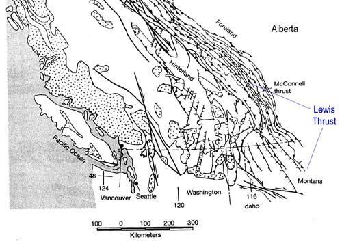
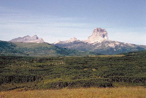
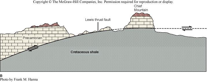
 How to Build a Mountain and other Geologic Structures But first, questions Questions your students might ask How were Montana s mountains formed? How old are the mountains? What are the different ways
KEY CHAPTER 12 TAKE-HOME QUIZ INTERNAL STRUCTURES AND PROCESSES Score Part B = / 55 PART B
 GEOLOGY 12 KEY CHAPTER 12 TAKE-HOME QUIZ INTERNAL STRUCTURES AND PROCESSES Score Part B = / 55 PART B CHAPTER 12 Isostacy and Structural Geology 1. Using the terms below, label the following diagrams and
Lecture 6 Folds, Faults and Deformation Dr. Shwan Omar
 Fold: A fold is a bend or wrinkle of rock layers or foliation; folds form as a sequence of ductile deformation. Folding is the processes by which crustal forces deform an area of crust so that layers of
CRUSTAL DEFORMATION. Chapter 10
 CRUSTAL DEFORMATION and dgeologic Structures t Chapter 10 Deformation Df Deformation involves: Stress the amount of force applied to a given area. Types of Stress: Confining Stress stress applied equally
Crustal Deformation. Earth Systems 3209
 Crustal Deformation Earth Systems 3209 Crustal Deformation pg. 415 Refers to all changes in the original form and/or size of a rock body. May also produce changes in the location and orientation of rocks.
What Causes Rock to Deform?
 Crustal Deformation Earth, Chapter 10 Chapter 10 Crustal Deformation What Causes Rock to Deform? Deformation is a general term that refers to all changes in the shape or position of a rock body in response
Strike-Slip Faults. ! Fault motion is parallel to the strike of the fault.
 Strike-Slip Faults! Fault motion is parallel to the strike of the fault.! Usually vertical, no hanging-wall/footwall blocks.! Classified by the relative sense of motion. " Right lateral opposite block
UNIT 10 MOUNTAIN BUILDING AND EVOLUTION OF CONTINENTS
 UNIT 10 MOUNTAIN BUILDING AND EVOLUTION OF CONTINENTS ROCK DEFORMATION Tectonic forces exert different types of stress on rocks in different geologic environments. STRESS The first, called confining stress
Crustal Deformation Earth - Chapter Pearson Education, Inc.
 Crustal Deformation Earth - Chapter 10 Structural Geology Structural geologists study the architecture and processes responsible for deformation of Earth s crust. A working knowledge of rock structures
Answers: Internal Processes and Structures (Isostasy)
") Answers: Internal Processes and Structures (Isostasy) 1. Analyse the adjustment of the crust to changes in loads associated with volcanism, mountain building, erosion, and glaciation by using the concept
Answers: Internal Processes and Structures (Isostasy) 1. Analyse the adjustment of the crust to changes in loads associated with volcanism, mountain building, erosion, and glaciation by using the concept
11.1 Rock Deformation
 Tarbuck Lutgens Mountain Building 11.1 Rock Deformation Factors Affecting Deformation Factors that influence the strength of a rock and how it will deform include temperature, confining pressure, rock
Deformation of Rocks. Orientation of Deformed Rocks
 Deformation of Rocks Folds and faults are geologic structures caused by deformation. Structural geology is the study of the deformation of rocks and its effects. Fig. 7.1 Orientation of Deformed Rocks
Crustal Deformation. (Building Earth s Surface, Part 1) Science 330 Summer Mapping geologic structures
 Science 330 Summer Mapping geologic structures") Crustal Deformation (Building Earth s Surface, Part 1) Science 330 Summer 2005 Mapping geologic structures When conducting a study of a region, a geologist identifies and describes the dominant rock structures
Crustal Deformation (Building Earth s Surface, Part 1) Science 330 Summer 2005 Mapping geologic structures When conducting a study of a region, a geologist identifies and describes the dominant rock structures
Chapter 10: Deformation and Mountain Building. Fig. 10.1
 Chapter 10: Deformation and Mountain Building Fig. 10.1 OBJECTIVES Describe the processes of rock deformation and compare and contrast ductile and brittle behavior in rocks. Explain how strike and dip
Lab 7: STRUCTURAL GEOLOGY FOLDS AND FAULTS
 Lab 7: STRUCTURAL GEOLOGY FOLDS AND FAULTS This set of labs will focus on the structures that result from deformation in earth s crust, namely folds and faults. By the end of these labs you should be able
Lecture 9 faults, folds and mountain building
 Lecture 9 faults, folds and mountain building Rock deformation Deformation = all changes in size, shape, orientation, or position of a rock mass Structural geology is the study of rock deformation Deformation
Earth Science, (Tarbuck/Lutgens) Chapter 10: Mountain Building
 Chapter 10: Mountain Building") Earth Science, (Tarbuck/Lutgens) Chapter 10: Mountain Building 1) A(n) fault has little or no vertical movements of the two blocks. A) stick slip B) oblique slip C) strike slip D) dip slip 2) In a(n) fault,
Earth Science, (Tarbuck/Lutgens) Chapter 10: Mountain Building 1) A(n) fault has little or no vertical movements of the two blocks. A) stick slip B) oblique slip C) strike slip D) dip slip 2) In a(n) fault,
Mountains and Mountain Building: Chapter 11
 Mountains and Mountain Building: Chapter 11 Objectives: 1)Explain how some of Earth s major mountain belts formed 2) Compare and contrast active and passive continental margins 3) Explain how compression,
Chapter 16. Mountain Building. Mountain Building. Mountains and Plate Tectonics. what s the connection?
 Chapter 16 Mountains and Plate Tectonics what s the connection? Mountain Building Most crustal deformation occurs along plate margins. S.2 Active Margin Passive Margin Mountain Building Factors Affecting
Chapter. Mountain Building
 Chapter Mountain Building 11.1 Rock Deformation Factors Affecting Deformation Factors that influence the strength of a rock and how it will deform include temperature, confining pressure, rock type, and
Faults, folds and mountain building
 Faults, folds and mountain building Mountain belts Deformation Orogens (Oro = Greek all changes for mountain, in size, shape, genesis orientation, = Greek for or formation) position of a rock mass Structural
Essentials of Geology, 11e
 Essentials of Geology, 11e Crustal Deformation and Mountain Building Chapter 17 Instructor Jennifer Barson Spokane Falls Community College Geology 101 Stanley Hatfield Southwestern Illinois College Jennifer
Section 3 Deforming Earth s Crust
 Section 3 Deforming Earth s Crust Key Concept Tectonic plate motions deform Earth s crust. Deformation causes rock layers to bend and break and causes mountains to form. What You Will Learn Stress is placed
Learning Objectives (LO) What we ll learn today:!
 What we ll learn today:!") Learning Objectives (LO) Lecture 13: Mountain Building Read: Chapter 10 Homework #11 due Tuesday 12pm What we ll learn today:! 1. Define the types of stress that are present in the crust! 2. Define the
Learning Objectives (LO) Lecture 13: Mountain Building Read: Chapter 10 Homework #11 due Tuesday 12pm What we ll learn today:! 1. Define the types of stress that are present in the crust! 2. Define the
Section 10.1 The Nature of Volcanic Eruptions This section discusses volcanic eruptions, types of volcanoes, and other volcanic landforms.
 Chapter 10 Section 10.1 The Nature of Volcanic Eruptions This section discusses volcanic eruptions, types of volcanoes, and other volcanic landforms. Reading Strategy Previewing Before you read the section,
Structural Geology and Geology Maps Lab
 Structural Geology and Geology Maps Lab Mesa College Geology 101 Lab Ray Rector: Instructor Structural Geology Lab Pre-Lab Resources Pre-Lab Internet Links 1) Fundamentals of Structural Geology 2) Visualizing
Study the architecture and processes responsible for deformation of Earth s crust. Folding and Faulting
 Crustal Deformation AKA Structural geology (adapted from Brunkel, 2012) Study the architecture and processes responsible for deformation of Earth s crust. Folding and Faulting How Rocks Deform: 4 Controls
Chapter 10: Volcanoes and Other Igneous Activity Section 1: The Nature of Volcanic Eruptions I. Factors Affecting Eruptions Group # Main Idea:
 Chapter 10: Volcanoes and Other Igneous Activity Section 1: The Nature of Volcanic Eruptions I. Factors Affecting Eruptions Group # A. Viscosity Group # B. Dissolved Gases Group # II. Volcanic Material
December 21, Chapter 11 mountain building E.notebook. Feb 19 8:19 AM. Feb 19 9:28 AM
 Mountains form along convergent plate boundaries. Typically (usually) if you look at a mountain range, you know that it is at a plate boundary (active continental margin) or has been some time in the past
Plate Tectonics. entirely rock both and rock
 Plate Tectonics I. Tectonics A. Tectonic Forces are forces generated from within Earth causing rock to become. B. 1. The study of the origin and arrangement of Earth surface including mountain belts, continents,
GEOLOGIC MAPS PART II
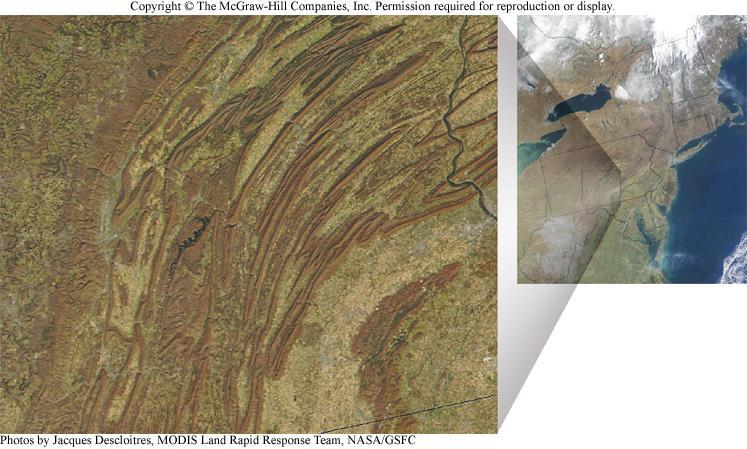
 EARTH AND ENVIRONMENT THROUGH TIME LABORATORY - EES 1005 LABORATORY FIVE GEOLOGIC MAPS PART II Introduction Geologic maps of orogenic belts are much more complex than maps of the stable interior. Just
Lecture Outlines PowerPoint. Chapter 10 Earth Science, 12e Tarbuck/Lutgens
 Lecture Outlines PowerPoint Chapter 10 Earth Science, 12e Tarbuck/Lutgens 2009 Pearson Prentice Hall This work is protected by United States copyright laws and is provided solely for the use of instructors
Lecture Outline Friday March 2 thru Wednesday March 7, 2018
 Lecture Outline Friday March 2 thru Wednesday March 7, 2018 Questions? Lecture Exam Friday March 9, 2018 Same time, Same room Bring Pencils and WSU ID 50 question Multiple Choice, Computer Graded Interlude
Mountains are then built by deforming crust: Deformation & Mountain Building. Mountains form where stresses are high!
 Deformation & Mountain Building Where are mountains located? Deformation and Folding Mountain building Mountains form where stresses are high! Mountains form at all three types of plate boundaries where
Convergent plate boundary.
 Crustal Deformation Convergent plate boundary http://my.execpc.com/~acmelasr/mountains/geogramsnf.html Plate Tectonic Settings and Magma Where plates CONVERGE, water is driven off the subducting plate,
4 Deforming the Earth s Crust
 CHAPTER 7 4 Deforming the Earth s Crust SECTION Plate Tectonics BEFORE YOU READ After you read this section, you should be able to answer these questions: What happens when rock is placed under stress?
Crags, Cracks, and Crumples: Crustal Deformation and Mountain Building
 Crags, Cracks, and Crumples: Crustal Deformation and Mountain Building Updated by: Rick Oches, Professor of Geology & Environmental Sciences Bentley University Waltham, Massachusetts Based on slides prepared
Forces That Shape Earth. How do continents move? What forces can change rocks? How does plate motion affect the rock cycle?
 Forces That Shape Earth How do continents move? What forces can change rocks? How does plate motion affect the rock cycle? Plate Motion Mountain ranges are produced by plate tectonics. The theory of plate
Geomorphology Final Exam Study Guide
 Geomorphology Final Exam Study Guide Geologic Structures STRUCTURAL GEOLOGY concerned with shapes, arrangement, interrelationships of bedrock units & endogenic (within) forces that cause them. Tectonic
Unit 4 Lesson 7 Mountain Building
 Indiana Standards 7.2.4 Explain how convection currents in the mantle cause lithospheric plates to move causing fast changes like earthquakes and volcanic eruptions, and slow changes like creation of mountains
Directed Reading. Section: How Mountains Form MOUNTAIN RANGES AND SYSTEMS. Skills Worksheet
 Skills Worksheet Directed Reading Section: How Mountains Form 1. How high is Mount Everest? a. about 1980 km above sea level b. more than 8 km below sea level c. more than 8 km above sea level d. more
FINAL EXAM Crustal Deformation CONVERGE DIVERGENT PLATES MANTLE PLUMES FLUX BASALTIC GRANITIC
 Crustal Deformation Reading: Chapter 10 Pages 283-304 Review Questions 4, 6, 7, 10, 12, 15, 18, 20 FINAL EXAM NOON TO 2 PM, TUESDAY DEC. 5 HERE: Natural Science 101 BRING A SCAN TRON TURN IN YOUR REVIEW
4 Deforming the Earth s Crust
 CHAPTER 7 4 Deforming the Earth s Crust SECTION Plate Tectonics BEFORE YOU READ After you read this section, you should be able to answer these questions: What happens when rock is placed under stress?
Name. GEOL.5220 Structural Geology Faults, Folds, Outcrop Patterns and Geologic Maps. I. Properties of Earth Materials
 I. Properties of Earth Materials GEOL.5220 Structural Geology Faults, Folds, Outcrop Patterns and Geologic Maps Name When rocks are subjected to differential stress the resulting build-up in strain can
Lecture # 6. Geological Structures
 1 Lecture # 6 Geological Structures ( Folds, Faults and Joints) Instructor: Dr. Attaullah Shah Department of Civil Engineering Swedish College of Engineering and Technology-Wah Cantt. 2 The wavy undulations
Part I. PRELAB SECTION To be completed before labs starts:
 Student Name: Physical Geology 101 Laboratory #13 Structural Geology II Drawing and Analyzing Folds and Faults Grade: Introduction & Purpose: Structural geology is the study of how geologic rock units
Unit 4 Lesson 3 Mountain Building. Copyright Houghton Mifflin Harcourt Publishing Company
 Stressed Out How can tectonic plate motion cause deformation? The movement of tectonic plates causes stress on rock structures. Stress is the amount of force per unit area that is placed on an object.
Shape Earth. Plate Boundaries. Building. Building
 Chapter Introduction Lesson 1 Lesson 2 Lesson 3 Lesson 4 Chapter Wrap-Up Forces That Shape Earth Landforms at Plate Boundaries Mountain Building Continent Building How is Earth s surface shaped by plate
Folding/Faulting: Topographic Expression of Folded Strata
 Folding/Faulting: Topographic Expression of Folded Strata Mountains: Orogenesis and Deformation Folding Faulting Joints & Fractures Domes and Basins Horst and Graben Rift Valleys US Examples: Sierra Nevada
1. classic definition = study of deformed rocks in the upper crust
 Structural Geology I. Introduction 1. classic definition = study of deformed rocks in the upper crust deformed includes translation, rotation, and strain (change of shape) All rocks are deformed in some
Staple this part to part one of lab 6 and turn in. Lab 6, part two: Structural geology (analysis)
") Geology 101 Staple this part to part one of lab 6 and turn in Lab 6, part two: Structural geology (analysis) Recall that the objective of this lab is to describe the geologic structures of Cougar Mountain
Geology 101 Staple this part to part one of lab 6 and turn in Lab 6, part two: Structural geology (analysis) Recall that the objective of this lab is to describe the geologic structures of Cougar Mountain
Lab 6: Plate tectonics, structural geology and geologic maps
 Geology 103 Name(s): Lab 6: Plate tectonics, structural geology and geologic maps Objective: To show the effects of plate tectonics on a large-scale set of rocks and to reconstruct the geological history
Movement of the Earth s Crust: Formation of: Mountain s Plateau's and Dome s
 Movement of the Earth s Crust: Formation of: Mountain s Plateau's and Dome s References Information taken from several places including Prentice Hall Earth Science: @ http://www.eram.k12.ny.us/education/components/docmgr/default.php?sectiondetaili
Instructor s Manual Chapter 10. Deformation, Mountain Building, and the Continents
 Chapter 10 Table of Contents Chapter Outline Learning Outcomes Chapter Summary Lecture Suggestions Enrichment Topics Common Misconceptions Consider This Key Terms Internet Sites, Videos, Software, and
6.1 Geological Stresses
 www.ck12.org Chapter 6. Geological Activity from Plate Tectonics Processes 6.1 Geological Stresses Define the types of geological stress and describe their affect on various types of rock under a range
Deformation of the Crust
 Deformation of the Crust Review Choose the best response. Write the letter of that choice in the space provided. 1. The state of balance between the thickness of the crust and the depth at which it rides
Theme 7. Metamorphic rocks. Distinguishing rock types
 Theme 7. Metamorphic rocks. Distinguishing rock types 7.1. Metamorphic rocks formation 7.2. Classification of metamorphic rocks 7.3. Distinguishing rock types 7.1. Metamorphic rocks formation 7.1. Metamorphic
FINAL EXAM Crustal Deformation CONVERGE DIVERGENT PLATES MANTLE PLUMES FLUX BASALTIC GRANITIC
 Crustal Deformation Reading: Chapter 10 Pages 283-294 FINAL EXAM 8 to 10 AM, THURSDAY DEC. 6 HERE: Natural Science 101 BRING A SCAN TRON TURN IN YOUR REVIEW QUESTIONS BEFORE THE TEST, PICK UP WHEN YOU
Tectonics is a study of the major structural features of the Earth s crust or a broad structure of a region. Tecto- means building
 TECTONICS AND TECTONIC STRUCTURES Tectonics is a study of the major structural features of the Earth s crust or a broad structure of a region. Tecto- means building The plate theory Different stages are
GLY 155 Introduction to Physical Geology, W. Altermann. Press & Siever, compressive forces. Compressive forces cause folding and faulting.
 Press & Siever, 1995 compressive forces Compressive forces cause folding and faulting. faults 1 Uplift is followed by erosion, which creates new horizontal surface. lava flows Volcanic eruptions cover
Evolution of Continents Chapter 20
 Evolution of Continents Chapter 20 Does not contain complete lecture notes. Mountain belts Orogenesis the processes that collectively produce a mountain belt Includes folding, thrust faulting, metamorphism,
Mountain Building. Mountain Building
 Mountain Building Mountain building has occurred during the recent geologic past American Cordillera the western margin of the Americas from Cape Horn to Alaska Includes the Andes and Rocky Mountains Alpine
Plate Tectonics - Demonstration
 Name: Reference: Prof. Larry Braile - Educational Resources Copyright 2000. L. Braile. Permission granted for reproduction for non-commercial uses. http://web.ics.purdue.edu/~braile/indexlinks/educ.htm
UNIT 6 PLATE TECTONICS
 UNIT 6 PLATE TECTONICS CONTINENTAL DRIFT Alfred Wegner proposed the theory that the crustal plates are moving over the mantle. He argued that today s continents once formed a single landmass, called Pangaea
Deformation: Modification of Rocks by Folding and Fracturing
 CHAPTER 7 Deformation: Modification of Rocks by Folding and Fracturing Chapter Summary A geologic map is a scientific model of rock formations that are exposed on the Earth s surface showing outcrops,
GEOL 110. Sedimentary Layering. Geologic Structures (faults, joints, folds), Unconformities, Karst. Sedimentary Layering 9/23/17. Geologic Structures
, Unconformities, Karst. Sedimentary Layering 9/23/17. Geologic Structures") GEOL 110 Sedimentary Layering Geologic Structures (faults, joints, folds), Unconformities, Karst Layering = horizontal, continuous banding produced during sediment deposition Sedimentary Layering Geologic
GEOL 110 Sedimentary Layering Geologic Structures (faults, joints, folds), Unconformities, Karst Layering = horizontal, continuous banding produced during sediment deposition Sedimentary Layering Geologic
Continental Landscapes
 Continental Landscapes Landscape influenced by tectonics, climate & differential weathering Most landforms developed within the last 2 million years System moves toward an equilibrium Continental Landscapes
YORK CASTLE HIGH SCHOOL CHRISTMAS TERM EXAMINATIONS GEOGRAPHY Duration 1 1 /2 HRS.
 GRADE 9 YORK CASTLE HIGH SCHOOL CHRISTMAS TERM EXAMINATIONS GEOGRAPHY Duration 1 1 /2 HRS. Name: 1. Label the internal structure of the earth provided below. WRITE on the space provide. Oceanic Crust/Upper
Geology of Landscapes Chapter 6 (Building Earth s Surface Faulting and Folding)
") Geology of Landscapes Chapter 6 (Building Earth s Surface Faulting and Folding) Process of _ that the earth s Stress and Strain Any solid material responds to a force in a way that depends on: pressure
Geology of Landscapes Chapter 6 (Building Earth s Surface Faulting and Folding) Process of _ that the earth s Stress and Strain Any solid material responds to a force in a way that depends on: pressure
Section 2: How Mountains Form
 Section 2: How Mountains Form Preview Objectives Mountain Ranges and Systems Plate Tectonics and Mountains Types of Mountains Objectives Identify the types of plate collisions that form mountains. Identify
10. Paleomagnetism and Polar Wandering Curves.
 Map of ocean floor Evidence in Support of the Theory of Plate Tectonics 10. Paleomagnetism and Polar Wandering Curves. The Earth's magnetic field behaves as if there were a bar magnet in the center of
An aerial view from the south of the eruption of Mount St. Helens volcano on May 18, 1980.
 1 2 3 4 5 6 7 8 9 10 Building Earth s Surface Tillery, Chapter 21 Science 330 Summer 2007 An aerial view from the south of the eruption of Mount St. Helens volcano on May 18, 1980. Interpreting Earth s
on the earthquake's strength. The Richter scale is a rating of an earthquake s magnitude based on the size of the
 Earthquakes and Seismic Waves An earthquake is the shaking and trembling that results from the movement of rock beneath Earth's surface. The point beneath Earth s surface where rock under stress breaks
1. occurs when the oceanic crust slides under the continental crust.
 1. occurs when the oceanic crust slides under the continental crust. 2. What type of stress is shown? 3. Where two plates slide past one another is called a boundary. 4. What type of stress is shown? 5.
Chapter Review USING KEY TERMS. asthenosphere uplift continental drift. known as. tectonic plates move. object. UNDERSTANDING KEY IDEAS
 Skills Worksheet Chapter Review USING KEY TERMS 1. Use the following terms in the same sentence: crust, mantle, and core. Complete each of the following sentences by choosing the correct term from the
NC Earth Science Essential Standards
 NC Earth Science Essential Standards EEn. 2.1 Explain how processes and forces affect the Lithosphere. EEn. 2.1.1 Explain how the rock cycle, plate tectonics, volcanoes, and earthquakes impact the Lithosphere.
You must take the exam in the lecture section for which you are registered. Any exceptions must be cleared with the instructor in advance.
 Geo 101, Fall 2000 Review Questions for Final Exam GEOLOGIC TIME AND FOLDING AND FAULTING THE FINAL EXAM FOR MWF CLASS WILL BE TUESDAY 1400 THE FINAL EXAM FOR TR CLASS WILL BE FRIDAY 930 These questions
Mohorovicic discontinuity separates the crust and the upper mantle.
 Structure of the Earth Chapter 7 The Earth is divided into 3 Main Layers 1. Crust outermost layer 1% of the Earth s mass thickness varies: 5 100 km two types: oceanic denser continental Mohorovicic discontinuity
Forces in Earth s Crust
 Forces in Earth s Crust This section explains how stresses in Earth s crust cause breaks, or faults, in the crust. The section also explains how faults and folds in Earth s crust form mountains. Use Target
Copyright McGraw-Hill Education. All rights reserved. No reproduction or distribution without the prior written consent of McGraw-Hill Education
 Copyright McGraw-Hill Education. All rights reserved. No reproduction or distribution without the prior written consent of McGraw-Hill Education Tibetan Plateau and Himalaya -southern Asia 11.00.a VE 10X
ANOTHER MEXICAN EARTHQUAKE! Magnitude 7.1, Tuesday Sept. 19, 2017
 ANOTHER MEXICAN EARTHQUAKE! Magnitude 7.1, Tuesday Sept. 19, 2017 Why is there no oceanic crust older than 200 million years? SUBDUCTION If new oceanic crust is being continuously created along the earth
Lab 1: Plate Tectonics April 2, 2009
 Name: Lab 1: Plate Tectonics April 2, 2009 Objective: Students will be introduced to the theory of plate tectonics and different styles of plate margins and interactions. Introduction The planet can be
A) B) C) D) 4. Which diagram below best represents the pattern of magnetic orientation in the seafloor on the west (left) side of the ocean ridge?
 B) C) D) 4. Which diagram below best represents the pattern of magnetic orientation in the seafloor on the west (left) side of the ocean ridge?") 1. Crustal formation, which may cause the widening of an ocean, is most likely occurring at the boundary between the A) African Plate and the Eurasian Plate B) Pacific Plate and the Philippine Plate C)
1. Crustal formation, which may cause the widening of an ocean, is most likely occurring at the boundary between the A) African Plate and the Eurasian Plate B) Pacific Plate and the Philippine Plate C)
Instructor: Ms. Terry J. Boroughs Geology 300 Restless/Dynamic EARTH: Geologic Structures (Folds & faults); Earthquakes; and the Earth s Interior
; Earthquakes; and the Earth s Interior") DATE DUE: Instructor: Ms. Terry J. Boroughs Geology 300 Name: Restless/Dynamic EARTH: Geologic Structures (Folds & faults); Earthquakes; and the Earth s Interior Instructions: Read each question carefully
DATE DUE: Instructor: Ms. Terry J. Boroughs Geology 300 Name: Restless/Dynamic EARTH: Geologic Structures (Folds & faults); Earthquakes; and the Earth s Interior Instructions: Read each question carefully
Mountains, like those shown in Figure 1, provide some of the most
 Section 11.1 11.1 Rock Deformation 1 FOCUS Section Objectives 11.1 Identify the factors that determine the strength of a rock and how it will deform. 11.2 Explain how rocks permanently deform. 11.3 Distinguish
Landforms and Rock Structure
 Landforms and Rock Structure Rock Structure as a Landform Control Landforms of Horizontal Strata and Coastal Plains Landforms of Warped Rock Layers Landforms Developed on Other Land-Mass Types Landforms
UNIT 3 GEOLOGY VOCABULARY FLASHCARDS THESE KEY VOCABULARY WORDS AND PHRASES APPEAR ON THE UNIT 3 CBA
 UNIT 3 GEOLOGY VOCABULARY FLASHCARDS THESE KEY VOCABULARY WORDS AND PHRASES APPEAR ON THE UNIT 3 CBA A map that shows Earth s Topographic Map surface topography, which is Earth s shape and features Contour
Forces in the Earth s crust
 EARTHQUAKES Forces in the Earth s crust How does stress in the crust change Earth s surface? Where are faults usually found, and why do they form? What land features result from the forces of plate movement?
Continental Drift and Plate Tectonics
 Continental Drift and Plate Tectonics Continental Drift Wegener s continental drift hypothesis stated that the continents had once been joined to form a single supercontinent. Wegener proposed that the
Plate Tectonics. Chapter 17. Great Idea: The entire Earth is still changing, due to the slow convection of soft, hot rocks deep within the planet.
 Plate Tectonics Chapter 17 Great Idea: The entire Earth is still changing, due to the slow convection of soft, hot rocks deep within the planet. 1 Chapter Outline The Dynamic Earth Plate Tectonics: A Unifying
(1) Identify 5 major principles of relative dating? For each principle, describe how you tell what is younger and what is older.
 Identify 5 major principles of relative dating? For each principle, describe how you tell what is younger and what is older.") Things to Know - Third GLG101Exam Page 1 Important Note: This is not everything you need to know or study. However, it provides you with a relatively comprehensive list of questions to help you study.
Things to Know - Third GLG101Exam Page 1 Important Note: This is not everything you need to know or study. However, it provides you with a relatively comprehensive list of questions to help you study.
Plate Tectonics. Theory of Plate Tectonics. What is Plate Tectonics. Plate Tectonics Plate Boundaries Causes of Plate Tectonics
 Theory of Plate Tectonics Plate Tectonics Plate Boundaries Causes of Plate Tectonics Plate Tectonics What is Plate Tectonics The Earth s crust and upper mantle are broken into sections called plates Plates
LANDFORMS. Patterns and Processes
 LANDFORMS Patterns and Processes Structure From the surface the Earth is a planet of continents and oceans. There is constant motion on the earth s surface. Seismology is the study of earthquakes. Scientists
Distribution of Continents Mid-ocean Ridges Trenches. Deformation Metamorphism Volcanism Earthquakes
 Earthquakes and Plate Tectonics Global Problems in Geology Distribution of Continents Mid-ocean Ridges Trenches Orogenic Belts Deformation Metamorphism Volcanism Earthquakes Development of Continental
Name Student ID Exam 2c GEOL 1113 Fall 2009
 Name Student ID Exam 2c GEOL 1113 Fall 2009 1. When a marine geologist collects a core of undeformed ocean-floor sediment, she knows that the youngest layer is on the top of the core and the oldest is
Chapter 7 Plate Tectonics. Plate tectonics accounts for important features of Earth s surface and major geologic events.
 Chapter 7 Plate Tectonics Plate tectonics accounts for important features of Earth s surface and major geologic events. 7-2 Alfred Wegener s Hypothesis of Continental Drift (1915) He noticed that the continents