Pre-eruptive ground deformation of Azerbaijan mud volcanoes detected through satellite radar interferometry (DInSAR)
|
|
|
- Martin Black
- 5 years ago
- Views:
Transcription
 Tectonophysics 637 (2014) 163 177 Speaker:Yi-Huei,Cho Advisor :Loung-Yie,Tsai")
1 Pre-eruptive ground deformation of Azerbaijan mud volcanoes detected through satellite radar interferometry (DInSAR) Tectonophysics 637 (2014) Speaker:Yi-Huei,Cho Advisor :Loung-Yie,Tsai Date:2016/12/08
2 Outline Introduction Method Result and Discussion Conclusion Future Work References 2

3 Introduction Detected time from October 2003 to November 2005 Azerbaijan Caspian Sea Iran Introduction Method Result and Discussion Conclusion Future Work References 3

4 Introduction Introduction Method Result and Discussion Conclusion Future Work References 4


5 Introduction Introduction Method Result and Discussion Conclusion Future Work References 5
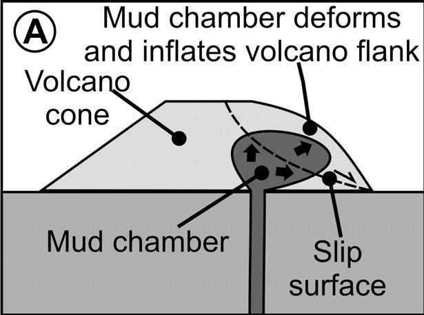
6 Introduction Mud volcano eruption : deeply buried sediments, saline waters, gases ( CH 4 ), mud and fragments of country rock. Mud volcanoes are usually developed at convergent plate margins. (Brown, 1990; Higgins and Saunders, 1974; Kopf, 2002) Introduction Method Result and Discussion Conclusion Future Work References 6
 Using the differential interferometry (DInSAR) technique applied to ENVISAT data.")
7 Introduction The eastern Greater Caucasus in Azerbaijan hosts the highest density of mud volcanoes in the world. ( Jakubov et al., 1971; Guliyev and Feizullayev, 1997 ) Using the differential interferometry (DInSAR) technique applied to ENVISAT data. Introduction Method Result and Discussion Conclusion Future Work References 7

8 Introduction Geologic setting of Azerbaijan mud volcanoes Introduction Method Result and Discussion Conclusion Future Work References 8
9 Method Two Synthetic Aperture Radar (SAR) image DInSAR (Hanssen, 2001) Two SAR image InSAR DTM Time Differential DInSAR Line of Sight, LOS 衛星視距方向 Introduction Method Result and Discussion Conclusion Future Work References 9
10 Method Two SAR DInSAR (Hanssen, 2001) φtopo : the effect of he different positions of the sensor at each acquisition time named topographic component. φmov : deformation contribution. φatm : the effect of atmospheric propagation. φnoise : is the sum of the instrumental noise and the contribution of the physical changes of each measured object which can affect radar response. Introduction Method Result and Discussion Conclusion Future Work References 10
11 Method Introduction Method Result and Discussion Conclusion Future Work References 11


12 Method Ayaz Akhtarma mud volcano Introduction Method Result and Discussion Conclusion Future Work References 12
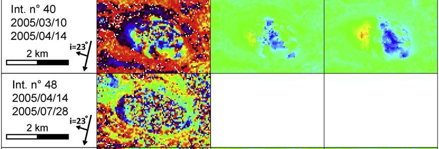
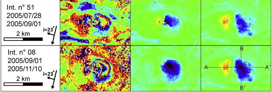
13 Result and Discussion The present study indicates that satellite radar interferometry represents a suitable tool for studying mud volcano activity. The results contribute to a wider understanding of the processes driving ground deformation at mud volcanoes. Introduction Method Result and Discussion Conclusion Future Work References 13
14 Conclusion Ground deformation patterns of mud volcanic edifices : 1. simultaneous uplift and subsidence areas. 2. fluid pressure and volume variations. 3. long eruption of mud volcanoes subsurface fluid mud inflation and redistribution Introduction Method Result and Discussion Conclusion Future Work References 14
15 Conclusion Mud volcanoes and magmatic volcanoes display some similarities : 1. ground deformation. 2. fluid pressure and gas volume variations. 3. pre-eruptive stages. Introduction Method Result and Discussion Conclusion Future Work References 15

16 Future Work Kaohsiung mud volcano : New Yangnu Lake Introduction Method Result and Discussion Conclusion Future Work References 16
17 References title page : mud volcanoes : DInSAR : Line of Sight, LOS : Introduction Method Result and Discussion Conclusion Future Work References 17
18 THANKS FOR YOUR ATTENTION
DINSAR ANALYSIS REVEALS BULGING OF AZERBAIJAN MUD VOLCANO EDIFICES BEFORE AN ERUPTION
 DINSAR ANALYSIS REVEALS BULGING OF AZERBAIJAN MUD VOLCANO EDIFICES BEFORE AN ERUPTION Benedetta Antonielli (1, 2), Oriol Monserrat (3), Marco Bonini (4), Gaia Righini (5), Federico Sani (1), Guido Luzi
MONITORING SUBSURFACE COAL FIRES USING SATELLITE-BASED OBSERVATIONS
 MONITORING SUBSURFACE COAL FIRES USING SATELLITE-BASED OBSERVATIONS Tajdarul H Syed Department of Applied Geology, Indian School of Mines, Dhanbad, India. CANEUS SSTDM 2014 SSTDM-2014 IISc, Bangalore Jharia
3D temporal evolution of displacements recorded on Mt. Etna from the 2007 to 2010 through the SISTEM method
 3D temporal evolution of displacements recorded on Mt. Etna from the 2007 to 2010 through the SISTEM method Bonforte A., Guglielmino F.,, Puglisi G. INGV Istituto Nazionale di Gofisica e vulcanologia Osservatorio
Application of satellite InSAR data for hydrocarbon reservoir monitoring
 Application of satellite InSAR data for hydrocarbon reservoir monitoring A. Tamburini, A. Belson, A. Ferretti, F. Novali TRE Milano, Italy Copyright - Tele-Rilevamento Europa - 2004 Outline SqueeSAR TM
Supporting the response to the 2018 lower East Rift Zone and summit collapse at Kīlauea Volcano, Hawaiʻi
 Hawaiʻi Supersite success story Supporting the response to the 2018 lower East Rift Zone and summit collapse at Kīlauea Volcano, Hawaiʻi Since 1983, Kīlauea Volcano, on the Island of Hawaiʻi, has actively
Earth Observatory of Singapore. Nina Lin 22 Jan 2018
 Earth Observatory of Singapore Nina Lin 22 Jan 2018 EOS Our Mission Our Mission Director Prof. Kerry Sieh The Earth Observatory of Singapore conducts fundamental research on earthquakes, volcanic eruptions,
NCC roles in successful disaster response I.R.IRAN
 The Second UN-GGIM-AP Plenary Meeting NCC roles in successful disaster response I.R.IRAN Teheran Iran 28-30 October 2013 Ali Javidaneh Technical Deputy of National Cartographic Center (NCC) Outline Types
What is the Relationship between Pressure & Volume Change in a Magma Chamber and Surface Deformation at Active Volcanoes?
 SSAC-pv2007.QE522.PL1.1 What is the Relationship between Pressure & Volume Change in a Magma Chamber and Surface Deformation at Active Volcanoes? What factors control the magnitude of surface deformation?
P079 First Results from Spaceborne Radar Interferometry for the Study of Ground Displacements in Urban Areas SUMMARY
 P079 First Results from Spaceborne Radar Interferometry for the Study of Ground Displacements in Urban Areas C.M. Crosetto (Instituto de Geomatica), C.A. Casas (University of Barcelona), R.G. Ranieri (University
Slow Deformation of Mt. Baekdu Stratovolcano Observed by Satellite Radar Interferometry
 Slow Deformation of Mt. Baekdu Stratovolcano Observed by Satellite Radar Interferometry Sang-Wan Kim and Joong-Sun Won Department of Earth System Sciences, Yonsei University 134 Shinchon-dong, Seodaemun-gu,
MEASURING VOLCANIC DEFORMATION AT UNIMAK ISLAND FROM 2003 TO 2010 USING
 MEASURING VOLCANIC DEFORMATION AT UNIMAK ISLAND FROM 2003 TO 2010 USING WEATHER MODEL-ASSISTED TIME SERIES INSAR Gong, W. a, Meyer, F. J. a, Lee, C. W. b, Lu, Z. c, Freymueller, J a. a. Geophysical Institute,
Modeling of Atmospheric Effects on InSAR Measurements With the Method of Stochastic Simulation
 Modeling of Atmospheric Effects on InSAR Measurements With the Method of Stochastic Simulation Z. W. LI, X. L. DING Department of Land Surveying and Geo-Informatics, Hong Kong Polytechnic University, Hung
InSAR measurements of volcanic deformation at Etna forward modelling of atmospheric errors for interferogram correction
 InSAR measurements of volcanic deformation at Etna forward modelling of atmospheric errors for interferogram correction Rachel Holley, Geoff Wadge, Min Zhu Environmental Systems Science Centre, University
ALOS PI Symposium 2009, 9-13 Nov 2009 Hawaii MOTION MONITORING FOR ETNA USING ALOS PALSAR TIME SERIES
 ALOS PI Symposium 2009, 9-13 Nov 2009 Hawaii ALOS Data Nodes: ALOS RA-094 and RA-175 (JAXA) MOTION MONITORING FOR ETNA USING ALOS PALSAR TIME SERIES Urs Wegmüller, Charles Werner and Maurizio Santoro Gamma
In order to obtain a long term monitoring result for the Kilauea Volcano, ALOS PALSAR images taken on Track 287, Frame 38, ascending orbit with 21.5 d
 ALOS PALSAR OBSERVATION OF KILAUEA VOLCANO ACTIVITIES FROM 2006 TO 2009 Zhe Hu, Linlin Ge, Xiaojing Li, Kui Zhang, Alex Hay-Man NG and Chris Rizos Cooperative Research Centre for Spatial Information &
Implementation of Multi-Temporal InSAR to monitor pumping induced land subsidence in Pingtung Plain, Taiwan
 Implementation of Multi-Temporal InSAR to monitor pumping induced land subsidence in Pingtung Plain, Taiwan Presenter: Oswald Advisor: Chuen-Fa Ni Date: March 09, 2017 Literature Review Pingtung Plain
Geochemistry, Geophysics, Geosystems. Supporting Information for
 1 2 3 4 5 6 7 8 Geochemistry, Geophysics, Geosystems Supporting Information for Volcano Deformation Survey over the Northern and Central Andes with ALOS InSAR Time Series Anieri M. Morales Rivera 1, Falk
Advanced interpretation of land subsidence by validating multiinterferometric SAR data: the case study of Anthemountas basin (Northern Greece)
") Revision of paper Advanced interpretation of land subsidence by validating multiinterferometric SAR data: the case study of Anthemountas basin (Northern Greece) By Raspini et al. General comments This
Revision of paper Advanced interpretation of land subsidence by validating multiinterferometric SAR data: the case study of Anthemountas basin (Northern Greece) By Raspini et al. General comments This
Ground surface deformation of L Aquila. earthquake revealed by InSAR time series
 Ground surface deformation of L Aquila earthquake revealed by InSAR time series Reporter: Xiangang Meng Institution: First Crust Monitoring and Application Center, CEA Address: 7 Naihuo Road, Hedong District
The financial and communal impact of a catastrophe instantiated by. volcanoes endlessly impact on lives and damage expensive infrastructure every
 Chapter 1 Introduction The financial and communal impact of a catastrophe instantiated by geophysical activity is significant. Landslides, subsidence, earthquakes and volcanoes endlessly impact on lives
GSNL - Geohazard Supersites and Natural Laboratories. Biennial report for Candidate/Permanent Supersite. Hawaiʻi Supersite. Annex to report
 Introduction Biennial report for Candidate/Permanent Supersite Hawaiʻi Supersite Annex to 2014 2016 report During 2014 2016, the Hawaiʻi Supersite achieved a number of noteworthy results. This annex details
Infrastructure monitoring using SAR interferometry
 Infrastructure monitoring using SAR interferometry Hossein Nahavandchi Roghayeh Shamshiri Norwegian University of Science and Technology (NTNU), Department of Civil and Environmental Engineering Geodesy
The Potential of High Resolution Satellite Interferometry for Monitoring Enhanced Oil Recovery
 The Potential of High Resolution Satellite Interferometry for Monitoring Enhanced Oil Recovery Urs Wegmüller a Lutz Petrat b Karsten Zimmermann c Issa al Quseimi d 1 Introduction Over the last years land
Radar Remote Sensing: Monitoring Ground Deformations and Geohazards from Space
 Radar Remote Sensing: Monitoring Ground Deformations and Geohazards from Space Xiaoli Ding Department of Land Surveying and Geo-Informatics The Hong Kong Polytechnic University A Question 100 km 100 km
Blanca Payàs 1, Ryan Morris 2, Alain Arnaud 1, David Albiol 1, John Bradshaw 3, Javier Duro 1. Abstract
 Surface monitoring using radar satellite images to measure ground deformation: applied to Coal Seam Gas production areas to comply with regulatory requirements Blanca Payàs 1, Ryan Morris 2, Alain Arnaud
3-Dimension Deformation Mapping from InSAR & Multiaperture. Hyung-Sup Jung The Univ. of Seoul, Korea Zhong Lu U.S. Geological Survey, U.S.A.
 3-Dimension Deformation Mapping from InSAR & Multiaperture InSAR Hyung-Sup Jung The Univ. of Seoul, Korea Zhong Lu U.S. Geological Survey, U.S.A. Outline Introduction to multiple-aperture InSAR (MAI) 3-D
Diverse deformation patterns of Aleutian volcanoes from InSAR
 Diverse deformation patterns of Aleutian volcanoes from InSAR Zhong Lu 1, Dan Dzurisin 1, Chuck Wicks 2, and John Power 3 U.S. Geological Survey 1 Cascades Volcano Observatory, Vancouver, Washington 2
CPO Science Middle School Earth Science Learning System Correlated to Ohio Science Academic Content Standards for Earth Science, grades 6-8
 CPO Science Middle School Earth Science Learning System Correlated to Ohio Science Academic Content Standards for Earth Science, grades 6-8 Earth and Space Science Benchmark A - Describe how the positions
SAR INTERFEROMETRIC ANALYSIS OF GROUND DEFORMATION AT SANTORINI VOLCANO (GREECE)
") SAR INTERFEROMETRIC ANALYSIS OF GROUND DEFORMATION AT SANTORINI VOLCANO (GREECE) Papageorgiou Elena (1), Foumelis Michael (2), Parcharidis Issaak (2) (1) National and Kapodistrian University of Athens,
SAR INTERFEROMETRIC ANALYSIS OF GROUND DEFORMATION AT SANTORINI VOLCANO (GREECE) Papageorgiou Elena (1), Foumelis Michael (2), Parcharidis Issaak (2) (1) National and Kapodistrian University of Athens,
Impact of the Envisat Mission Extension on SAR data
 Impact of the Envisat Mission Extension on SAR data Impact of Envisat extension on SAR data Prepared by nuno miranda Reference Issue 0.9 Revision Date of Issue 23 August 2010 Status Preliminary version
Coupled geomechanics and InSAR inversion of CO2 injection parameters
 11512. Scrutinizing CO2 Sequestration - A Case Study Coupling InSAR and Geomechanical Modelling to Monitor Spatial and Temporal Characteristics of CO2 Injection at In Salah, Algeria N. Gourmelen (University
DIFFERENTIAL INSAR STUDIES IN THE BOREAL FOREST ZONE IN FINLAND
 DIFFERENTIAL INSAR STUDIES IN THE BOREAL FOREST ZONE IN FINLAND Kirsi Karila (1,2), Mika Karjalainen (1), Juha Hyyppä (1) (1) Finnish Geodetic Institute, P.O. Box 15, FIN-02431 Masala, Finland, Email:
Basics of the modelling of the ground deformations produced by an earthquake. EO Summer School 2014 Frascati August 13 Pierre Briole
 Basics of the modelling of the ground deformations produced by an earthquake EO Summer School 2014 Frascati August 13 Pierre Briole Content Earthquakes and faults Examples of SAR interferograms of earthquakes
The Santorini Inflation Episode, Monitored by InSAR and GPS
 The Santorini Inflation Episode, Monitored by InSAR and GPS Ioannis Papoutsis 1,2, Xanthos Papanikolaou 2, Michael Floyd 3, Kang Hyeun Ji 4, Charalampos Kontoes 1, Demitris Paradissis 2, Demitris Anastasiou
Urban land and infrastructure deformation monitoring by satellite radar interferometry
 Urban land and infrastructure deformation monitoring by satellite radar interferometry Lei Zhang and Xiaoli Ding Department of Land Surveying and Geo-Informatics (LSGI) The Hong Kong Polytechnic University
COMPOSITION and PHYSICAL PROPERTIES GENERAL SUBJECTS. GEODESY and GRAVITY
 COMPOSITION and PHYSICAL PROPERTIES Composition and structure of the continental crust Composition and structure of the core Composition and structure of the mantle Composition and structure of the oceanic
Impact of the Envisat Mission Extension on SAR data
 Impact of the Envisat Mission Extension on SAR data Impact of Envisat Mission Extension on SAR data - 1.0 Prepared by Nuno Miranda, Berthyl Duesmann, Monserrat Pinol, Davide Giudici, Davide D Aria Reference
InSAR, structural analyses and dating of Paka volcanic products, Northern Kenya Rift
 Andrea Friese InSAR, structural analyses and dating of Paka volcanic products, Northern Kenya Rift Final Report TECHNICAL COOPERATION PROJECT NO.: 2009.2222.9 FEDERAL INSTITUTE FOR GEOSCIENCES AND NATURAL
GPS and GIS Assisted Radar Interferometry
 GPS and GIS Assisted Radar Interferometry Linlin Ge, Xiaojing Li, Chris Rizos, and Makoto Omura Abstract Error in radar satellite orbit determination is a common problem in radar interferometry (INSAR).
GEO-VIII November Geohazard Supersites and Natural Laboratories Progress Report. Document 9
 GEO-VIII 16-17 November 2011 Geohazard Supersites and Natural Laboratories Progress Report Document 9 This document is submitted to GEO-VIII for information. Geohazard Supersites and Natural Laboratories
Ground deformation monitoring at the Phlegrean Fields (Naples, Italy) from the exploitation of SAR data in the framework of CAT-1 and DUP activities
 from the exploitation of SAR data in the framework of CAT-1 and DUP activities") Ground deformation monitoring at the Phlegrean Fields (Naples, Italy) from the exploitation of SAR data in the framework of CAT-1 and DUP activities Borgström S., Aquino I., Del Gaudio C., Ricco C., Siniscalchi
Ground deformation monitoring at the Phlegrean Fields (Naples, Italy) from the exploitation of SAR data in the framework of CAT-1 and DUP activities Borgström S., Aquino I., Del Gaudio C., Ricco C., Siniscalchi
TEMPORAL VARIABILITY OF ICE FLOW ON HOFSJÖKULL, ICELAND, OBSERVED BY ERS SAR INTERFEROMETRY
 TEMPORAL VARIABILITY OF ICE FLOW ON HOFSJÖKULL, ICELAND, OBSERVED BY ERS SAR INTERFEROMETRY Florian Müller (1), Helmut Rott (2) (1) ENVEO IT, Environmental Earth Observation GmbH, Technikerstrasse 21a,
InSAR techniques and applications for monitoring landslides and subsidence
 Geoinformation for European-wide Integration, Benes (ed.) 2003 Millpress, Rotterdam, ISBN 90-77017-71-2 InSAR techniques and applications for monitoring landslides and subsidence H. Rott & T. Nagler Institut
ASAR IMAGES A DIVERSE SET OF DEFORMATION PATTERNS AT KĪLAUEA VOLCANO, HAWAI`I
 ASAR IMAGES A DIVERSE SET OF DEFORMATION PATTERNS AT KĪLAUEA VOLCANO, HAWAI`I Michael P. Poland (1) (1) U.S. Geological Survey, Hawaiian Volcano Observatory, 51 Crater Rim Road, Hawai`i National Park,
Evolution of the 2007 earthquake swarm, Tanzania: Envisat and ALOS interferometry, ground observations and elastic modeling
 Evolution of the 2007 earthquake swarm, Tanzania: Envisat and ALOS interferometry, ground observations and elastic modeling Gidon Baer, Yariv Hamiel, Gadi Shamir, Ran Nof Geological Survey of Israel East
MODELING INTERFEROGRAM STACKS FOR SENTINEL - 1
 MODELING INTERFEROGRAM STACKS FOR SENTINEL - 1 Fabio Rocca (1) (1) Politecnico di Milano, Via Ponzio 34/5, 20133 Milano, Italy, Email: rocca@elet.polimi.it ABSTRACT The dispersion of the optimal estimate
On the variations of InSAR-ICA altitudes in a mountain area of the Sele Valley (South Italy)
") ANNALS OF GEOPHYSICS, VOL. 52, N. 2, April 2009 On the variations of InSAR-ICA altitudes in a mountain area of the Sele Valley (South Italy) Paola Ballatore Mediterranean Agency for Remote Sensing and
ANNALS OF GEOPHYSICS, VOL. 52, N. 2, April 2009 On the variations of InSAR-ICA altitudes in a mountain area of the Sele Valley (South Italy) Paola Ballatore Mediterranean Agency for Remote Sensing and
The Removal of Lava Flow Subsidence Signals from deformation interferograms at Nyamuragira Volcano, D.R. Congo
 The Removal of Lava Flow Subsidence Signals from deformation interferograms at Nyamuragira Volcano, D.R. Congo Andy Toombs & Geoff Wadge Environmental Systems Science Centre National Centre for Earth Observation
Detecting Illegal Mining Activities Using DInSAR
 Detecting Illegal Mining Activities Using DInSAR H.S. Kutoglu 1, H. Akcin 1, T. Deguchi 2, H. Kemaldere 1 1 Zonguldak Karaelmas Universitesi,, Türkiye; T 2 ERSDAC, Japan 17.06.2008 TS4D_3031 Study Area
Spaceborne radar applications in Geology
 216 051 ESATM-17 December 2005 Spaceborne radar applications in Geology An introduction to imaging radar, and application examples of ERS SAR in Geology and Geomorphology European Spate Agency Agente spatiale
Level 3 Earth and Space Science, 2017
 91414 914140 3SUPERVISOR S Level 3 Earth and Space Science, 2017 91414 Demonstrate understanding of processes in the atmosphere system 2.00 p.m. Monday 27 November 2017 Credits: Four Achievement Achievement
Application of advanced InSAR techniques for the measurement of vertical and horizontal ground motion in longwall minings
 University of Wollongong Research Online Coal Operators' Conference Faculty of Engineering and Information Sciences 2013 Application of advanced InSAR techniques for the measurement of vertical and horizontal
Mud Volcanoes in the South Caspian Basin: Activity Inferred From ENVISAT ASAR Images
 Mud Volcanoes in the South Caspian Basin: Activity Inferred From ENVISAT ASAR Images Martin Weinelt & Warner Brückmann Helmholtz Centre for Ocean Research Kiel 1 Mud Volcanoes in the South Caspian Basin
Images from: Boston.com
 Images from: Boston.com Ireland in the shadow of a volcano: Understanding the 2010 eruption at Eyjafjallajökull, Iceland. Chris Bean, School of Geological Sciences, UCD. World Quakes and Volcanoes 1960-2010
Dr. Simon Plank. German Remote Sensing Data Center (DFD), German Aerospace Center (DLR)
, German Aerospace Center (DLR)") Pre-survey suitability analysis of the differential and persistent scatterer synthetic ti aperture radar interferometry t method for deformation monitoring of landslides Dr. Simon Plank German Remote Sensing
Pre-survey suitability analysis of the differential and persistent scatterer synthetic ti aperture radar interferometry t method for deformation monitoring of landslides Dr. Simon Plank German Remote Sensing
INFRARED AND SATELLITE IMAGES, AERIAL PHOTOGRAPHY
 Presented at Short Course VI on Exploration for Geothermal Resources, organized by UNU-GTP, GDC and KenGen, at Lake Bogoria and Lake Naivasha, Kenya, Oct. 27 Nov. 18, 2011. GEOTHERMAL TRAINING PROGRAMME
Deformation measurement using SAR interferometry: quantitative aspects
 Deformation measurement using SAR interferometry: quantitative aspects Michele Crosetto (1), Erlinda Biescas (1), Ismael Fernández (1), Ivan Torrobella (1), Bruno Crippa (2) (1) (2) Institute of Geomatics,
Speaker: Ing. Giorgio Barsacchi. Kinematics of the Slumgullion Landslide Revealed by Ground based InSAR Surveys
 Kinematics of the Slumgullion Landslide revealed by Ground based InSAR Survey Speaker: Ing. Giorgio Barsacchi Giorgio Barsacchi Kinematics of the Slumgullion Landslide Revealed by Ground based InSAR Surveys
1. minerals - A naturally occurring substance that takes a solid Crystal form and is made of only a single (one) type of compound
 type of compound") Science Name: Mr. G/Mrs. Kelly KEY Date: Study Guide - Lessons 5 and 6 Test Define the following terms: 1. minerals - A naturally occurring substance that takes a solid Crystal form and is made of only
Science Name: Mr. G/Mrs. Kelly KEY Date: Study Guide - Lessons 5 and 6 Test Define the following terms: 1. minerals - A naturally occurring substance that takes a solid Crystal form and is made of only
DETECTION OF CRUSTAL DEFORMATION OF THE NORTHERN PAKISTAN EARTHQUAKE BY SATELLITE DATA. Submitted by Japan **
 UNITED NATIONS E/CONF.97/5/CRP. 5 ECONOMIC AND SOCIAL COUNCIL Seventeenth United Nations Regional Cartographic Conference for Asia and the Pacific Bangkok, 18-22 September 2006 Item 6 (b) of the provisional
Inflation of the Aira Caldera (Japan) detected over Kokubu urban area using SAR interferometry ERS data
 detected over Kokubu urban area using SAR interferometry ERS data") Inflation of the Aira Caldera (Japan) detected over Kokubu urban area using SAR interferometry ERS data D. Remy, S. Bonvalot, M. Murakami, P. Briole, S. Okuyama To cite this version: D. Remy, S. Bonvalot,
Inflation of the Aira Caldera (Japan) detected over Kokubu urban area using SAR interferometry ERS data D. Remy, S. Bonvalot, M. Murakami, P. Briole, S. Okuyama To cite this version: D. Remy, S. Bonvalot,
Excerpt from the Proceedings of the COMSOL Conference 2009 Milan
 Excerpt from the Proceedings of the COMSOL Conference 2009 Milan Simulated Annealing and Genetic Algorithm Optimization using COMSOL Multiphysics: Applications to the Analysis of Ground Deformation in
Integration of InSAR and GIS for Monitoring of Subsidence Induced by Block Caving Mining
 Integration of InSAR and GIS for Monitoring of Subsidence Induced by Block Caving Mining Dr. Andrew JAROSZ and Mr. Hani ZAHIRI, Australia Key words: subsidence, block caving, mine deformation, GIS, InSAR,
PERSISTENT SCATTERER INTERFEROMETRY: POTENTIAL AND LIMITS
 PERSISTENT SCATTERER INTERFEROMETRY: POTENTIAL AND LIMITS M. Crosetto a, O. Monserrat a, A. Jungner, B. Crippa b a Institute of Geomatics, Av. del Canal Olímpic, s/n, Castelldefels, E-08860, Spain (michele.crosetto,
A MODEL FOR RISES AND DOWNS OF THE GREATEST LAKE ON EARTH
 A MODEL FOR RISES AND DOWNS OF THE GREATEST LAKE ON EARTH Parviz Tarikhi Iranian Remote Sensing Center, Iran May 2005 1 Figure 1: West of Novshahr in the Iranian coast of Caspian; the dam constructed to
G. Ventura* a, Vilardo G. b, V. Sepe a. Napoli, Italy, INTRODUCTION ABSTRACT
 Monitoring and structural significance of ground deformations at Campi Flegrei supervolcano (Italy) from the combined 2D and 3D analysis of PS-InSAR, geophysical, geological and structural data G. Ventura*
Subject Classification
 Istituto Nazionale di Geofisica e Vulcanologia earth-prints home page roma library bologna library catania library milano library napoli library palerm Subject Classification Earth-prints organize its
Unit 2 Lesson 1 Geologic Change over Time. Copyright Houghton Mifflin Harcourt Publishing Company
 Been There, Done That What is the principle of uniformitarianism? The principle of uniformitarianism states that geologic processes that happened in the past can be explained by current geologic processes.
Deformation of the Augustine Volcano, Alaska, , measured by ERS and ENVISAT SAR interferometry
 Earth Planets Space, 60, 447 452, 2008 Deformation of the Augustine Volcano, Alaska, 1992 2005, measured by ERS and ENVISAT SAR interferometry Chang-Wook Lee 1,3, Zhong Lu 2, Oh-Ig Kwoun 3, and Joong-Sun
to: Interseismic strain accumulation and the earthquake potential on the southern San
 Supplementary material to: Interseismic strain accumulation and the earthquake potential on the southern San Andreas fault system by Yuri Fialko Methods The San Bernardino-Coachella Valley segment of the
Available online at GHGT-9. Detection of surface deformation related with CO 2 injection by DInSAR at In Salah, Algeria
 Available online at www.sciencedirect.com Energy Procedia 100 (2009) (2008) 2177 2184 000 000 Energy Procedia www.elsevier.com/locate/procedia www.elsevier.com/locate/xxx GHGT-9 Detection of surface deformation
ATMOSPHERIC EFFECTS REMOVAL OF ASAR-DERIVED INSAR PRODUCTS USING MERIS DATA AND GPS
 ATMOSPHERIC EFFECTS REMOVAL OF ASAR-DERIVED INSAR PRODUCTS USING MERIS DATA AND GPS S. Adham Khiabani a, M. J. Valadan Zoej a, M. R. Mobasheri a, M. Dehghani a Geodesy and Geomatics Engineering Faculty,
Mass Wasting and Landscape Evolution
 Mass Wasting and Landscape Evolution 11-8-06 Uplift is a tectonic process Three types of uplift: 1. Collisional uplift 2. isostatic uplift 3. Extensional uplif. A physical experiment in isostasy: [crust
Standards. Lesson Plan: Glaciers. Earth Science Grade 3. Grade 4. Grade 7. Grade 8
 Lesson Plan: Glaciers Grade 3 Standards 3-5 Benchmark C. Describe Earth s resources including rocks, soil, water, air, animals and plants and the ways in which they can be conserved. Earth Systems / Y2003.CSC.S01.G03-05.BC.L03.I03
Innovative Applications of Satellite Interferometry in the Oil&Gas Industry
 Innovative Applications of Satellite Interferometry in the Oil&Gas Industry A. Ferretti (1), G. Falorni (3), F. Novali (1), F. Rocca (2), A. Rucci (2), A. Tamburini (1) (1) Tele-Rilevamento Europa - TRE
CHINA-ITALY BILATERAL SYMPOSIUM ON THE COASTAL ZONE: EVOLUTION AND SAFEGUARD
 CHINA-ITALY BILATERAL SYMPOSIUM ON THE COASTAL ZONE: EVOLUTION AND SAFEGUARD 4-8 November 2007 Bologna, ITALY Editors F.Marabini, A.Galvani, M.Ciabatti Editorial Assistant M.Barazutti C.N.R. Bologna LAND
Introduction to Acoustic Remote Sensing and Seafloor Mapping (AE4-E13) May 19, 2010
 May 19, 2010") Introduction to Acoustic Remote Sensing and Seafloor Mapping (AE4-E13) May 19, 2010 1 Delft Vermelding Institute onderdeel of Earth organisatie Observation and Space Systems Why Acoustic Remote Sensing?
Introduction to Acoustic Remote Sensing and Seafloor Mapping (AE4-E13) May 19, 2010 1 Delft Vermelding Institute onderdeel of Earth organisatie Observation and Space Systems Why Acoustic Remote Sensing?
Interferometric Synthetic Aperture Radar (InSAR): Its Past, Present and Future
: Its Past, Present and Future") Interferometric Synthetic Aperture Radar (InSAR): Its Past, Present and Future by Zhong Lu, Ohig Kwoun, and Russell Rykhus Introduction Very simply, interferometric synthetic aperture radar (InSAR) involves
Interferometric Synthetic Aperture Radar (InSAR): Its Past, Present and Future by Zhong Lu, Ohig Kwoun, and Russell Rykhus Introduction Very simply, interferometric synthetic aperture radar (InSAR) involves
Canary in the Coal Mine: Subsidence in Coastal Louisiana Press Conference
 Canary in the Coal Mine: Subsidence in Coastal Louisiana Press Conference Samuel Bentley, LSU Department of Geology & Geophysics professor and Billy and Ann Harrison chair in sedimentary geology Mead Allison,
Ivana Zinno, Francesco Casu, Claudio De Luca, Riccardo Lanari, Michele Manunta. CNR IREA, Napoli, Italy
 An Unsupervised Implementation of the P-SBAS DiNSAR Algorithm for Processing Large Data Volumes through Distributed Computing Infrastructures within Operational Environments Ivana Zinno, Francesco Casu,
Current challenges at CO 2 Sites
 Current challenges at CO 2 Sites Ola Eiken et al., Statoil R&D Force seminar on injection safety 4 th December 2013 Offshore Sleipner Onshore In Salah Sub-sea Snøhvit 1 - Classification: External 2010-09-23
Volcanoes Session. Chairs: Y. Fukushima & G. Puglisi
 Volcanoes Session Chairs: Y. Fukushima & G. Puglisi Presentation Summary We had presentations on volcanoes all over the world, more than the last FRINGE workshops: Etna, Campi Flegrei, Ethiopian rift,
INGV. Giuseppe Pezzo. Istituto Nazionale di Geofisica e Vulcanologia, CNT, Roma. Sessione 1.1: Terremoti e le loro faglie
 Giuseppe Pezzo Istituto Nazionale di Geofisica e Vulcanologia, CNT, Roma giuseppe.pezzo@ingv.it The study of surface deformation is one of the most important topics to improve the knowledge of the deep
Directed Reading. Section: Types of Maps
 Skills Worksheet Directed Reading Section: Types of Maps 1. What are some of the characteristics of an area shown on maps used by Earth scientists? a. types of animals, types of plants, types of minerals
Adapted by Karla Panchuk from Physical Geology by Steven Earle
 Physical Geology, 3 rd Adapted Edition is used under a CC BY 4.0 International License Read this book online at http://openpress.usask.ca/physicalgeology/ Chapter 6. The Rock Cycle Adapted by Karla Panchuk
Earthquakes. Earthquakes are caused by a sudden release of energy
 Earthquakes Earthquakes are caused by a sudden release of energy The amount of energy released determines the magnitude of the earthquake Seismic waves carry the energy away from its origin Fig. 18.1 Origin
Evolution and future of the Lusi mud eruption inferred from ground deformation
 GEOPHYSICAL RESEARCH LETTERS, VOL.???, XXXX, DOI:.9/, Evolution and future of the Lusi mud eruption inferred from ground deformation M. L. Rudolph, M. Shirzaei, M. Manga, and Y. Fukushima The ongoing eruption
Arizona Educator Proficiency Assessments (AEPA )
") Arizona Educator Proficiency Assessments (AEPA ) TEST OBJECTIVES January 2011 Subarea Range of Objectives Approximate Test Proportions I. Characteristics of Science 1 5 22% II. Origin and Evolution of
Arizona Educator Proficiency Assessments (AEPA ) TEST OBJECTIVES January 2011 Subarea Range of Objectives Approximate Test Proportions I. Characteristics of Science 1 5 22% II. Origin and Evolution of
DETECTING ICE MOTION IN GROVE MOUNTAINS, EAST ANTARCTICA WITH ALOS/PALSAR AND ENVISAT/ASAR DATA
 DETECTING ICE MOTION IN GROVE MOUNTAINS, EAST ANTARCTICA WITH ALOS/PALSAR AND ENVISAT/ASAR DATA TIAN Xin (1), LIAO Mingsheng (1), ZHOU Chunxia (2), ZHOU Yu (3) (1) State Key Laboratory of Information Engineering
Volcanic Monitoring in Long Valley, California. creating a ten-mile by twenty-mile caldera in the Eastern Sierra Nevada region of
 Jensen Grimmer G188 6/6/2013 Volcanic Monitoring in Long Valley, California Abstract: Around 760,000 years ago an explosive eruption shook the western United States creating a ten-mile by twenty-mile caldera
What landforms make up Australia?!
 What landforms make up Australia? The tectonic forces of folding, faulting and volcanic activity have created many of Australia's major landforms. Other forces that work on the surface of Australia, and
GEODETIC EVIDENCE FOR SLOW INFLATION OF THE SANTORINI CALDERA
 Proceedings, 11 th FIG Symposium on Deformation Measurements, Santorini, Greece, 2003. GEODETIC EVIDENCE FOR SLOW INFLATION OF THE SANTORINI CALDERA Stathis Stiros 1, Aris Chasapis 2 and Villy Kontogianni
RAYMOND SIEVER Harvard University
 E A R T H FOURTH EDITION FRANK PRESS National Academy of Sciences RAYMOND SIEVER Harvard University W. H. Freeman and Company New York Preface xiii Acknowledgments xviii PART I PROLOGUE CHAPTER 1 HISTORY
Topics: The Layers of the Earth and its Formation Sources of Heat Volcanos and Earthquakes Rock Cycle Rock Types Carbon Tax
 Topics: The Layers of the Earth and its Formation Sources of Heat Volcanos and Earthquakes Rock Cycle Rock Types Carbon Tax Essay Question on Carbon Tax 1. Drilling 2. Volcanic Activity 3. Laboratory experiments
Question #1: What are some ways that you think the climate may have changed in the area where you live over the past million years?
 Reading 5.2 Environmental Change Think about the area where you live. You may see changes in the landscape in that area over a year. Some of those changes are weather related. Others are due to how the
!"#$%&' #(!()* +,-'.,$ &%!/(%)!'%
* +,-'.,$ &%!/(%)!'%") !"#$%&' #(!()* +,-'.,$ &%!/(%)!'% /01234 5013673 Iranian Remote Sensing Center (IRSC) No. 22, 14 th Street, Saadat-Abad Tehran 19979, Iran Tel: +98 21 2063207 Fax: +98 21 2064474 E-mail: irsc@www.dci.co.ir
!"#$%&' #(!()* +,-'.,$ &%!/(%)!'% /01234 5013673 Iranian Remote Sensing Center (IRSC) No. 22, 14 th Street, Saadat-Abad Tehran 19979, Iran Tel: +98 21 2063207 Fax: +98 21 2064474 E-mail: irsc@www.dci.co.ir
USU 1360 TECTONICS / PROCESSES
 USU 1360 TECTONICS / PROCESSES Observe the world map and each enlargement Pacific Northwest Tibet South America Japan 03.00.a1 South Atlantic Arabian Peninsula Observe features near the Pacific Northwest
Bonn, Germany MOUTAZ DALATI. General Organization for Remote Sensing ( GORS ), Syria Advisor to the General Director of GORS,
, Syria Advisor to the General Director of GORS,") Bonn, Germany Early Warning System is needed for Earthquakes disaster mitigation in Syria Case Study: Detecting and Monitoring the Active faulting zones along the Afro-Arabian-Syrian Rift System MOUTAZ
Bonn, Germany Early Warning System is needed for Earthquakes disaster mitigation in Syria Case Study: Detecting and Monitoring the Active faulting zones along the Afro-Arabian-Syrian Rift System MOUTAZ
THE USE OF DIFFERENT REMOTE SENSING TECHNIQUES FOR LANDSLIDE CHARACTERIZATION
 THE USE OF DIFFERENT REMOTE SENSING TECHNIQUES FOR LANDSLIDE CHARACTERIZATION Ph.D. candidate: ANNA DE AGOSTINI Tutor: Dr. M. FLORIS Cycle: XXVI Abstract The aim of my research is to investigate the potential
Applied Terrestrial Laser Scanner in active volcano crater: correction to velocity and geometry
 Applied Terrestrial Laser Scanner in active volcano crater: correction to velocity and geometry Nia HAERANI, Hasanuddin Z. ABIDIN, SURONO, Dudy D. WIJAYA, Indonesia FIG Working Week 2015 From the Wisdom