40 Years Listening to the Beat of the Earth
|
|
|
- Dorthy Cook
- 5 years ago
- Views:
Transcription

1 EU-LA Mining & Exploration Convention Earth Observation in support of sustainable mining by the Geological Surveys of Europe Gerardo Herrera Veronika Kopačková Eleftheria Poyiadji Maria Przyłucka 40 Years Listening to the Beat of the Earth

2 Summary 1. Earth Observation and Geohazards Expert Group from EuroGeoSurveys 2. Earth Observation tools to assess mineral resources 3. Earth Observation tools to monitor mining impacts 4. Earth Observation research and future development
3 Summary 1. Earth Observation and Geohazards Expert Group from EuroGeoSurveys 2. Earth Observation tools for mineral exploration 3. Earth Observation tools for mining impact assessment 4. H2020 Geo-Cradle project: 5. Future perspectives
4 Earth Observation and Geohazards Expert Group from EuroGeoSurveys


")

5 37 Geological Surveys SPATIAL INFORMATION (INSPIRE) GEOCHEMISTRY INTERNATIONAL COOPERATION AND DEVELOPMENT MINERAL RESOURCES EARTH OBSERVATION AND GEOHAZARDS MARINE GEOLOGY GEOENERGY WATER RESOURCES


:")
6 Earth Observation and Geohazards Expert Group Members: 28 Geological Surveys and 80 scientists Mission and Vision: Assessment of geohazards Application of Earth Observation tools to exploration and mining Deputy chairs: Veronika Kopackova (CZH): responsible for Raw materials EO Eleftheria Poyiadji (IGME GR): responsible for H2020 Geo-Cradle project Maria Przyłucka (PGI): responsible for H2020 Geo-Cradle pilots 6

7 Earth Observation and Geohazards Expert Group 7

8 Earth Observation and Geohazards Expert Group 8
9 Earth Observation tools for mineral exploration Veronika Kopačková


. DOI 10.")
10 Earth Observation tools for mineral exploration Mineral thematic map showing surface geological materials from airborne multispectral and hyperspectral data Sokolov Lignite Open-Pit Mines, Czech Republic Notesco, G. Kopačková V. Rojík, P. Schwartz, G. Livne, I. Ben-Dor, E. (2014): Mineral Classification of Land Surface Using Multispectral LWIR and Hyperspectral SWIR Remote-Sensing Data. A Case Study over the Sokolov Lignite Open-Pit Mines, the Czech Republic. Remote Sensing 6, 8, ISSN (on line). DOI /rs Higher Quartz content 5 Higher Phyllosilicatescontent


 Imaging spectroscopy answers to")
11 Earth Observation tools for mineral exploration Mining waste mapping derived from hyperspectral and field data Case study, S. Domingos Mine Iberian pyrite Belt Quental, L. Sousa, A.J, Marsh, S., Brito, G. Abreu, M.M. (2011) Imaging spectroscopy answers to acid mine drainage detection, Iberian Pyrite Belt, Portugal. Comunicações Geológicas, 98,


12 Earth Observation tools for mineral exploration Mapping mineral content of surface water from hyperspectral and HR optical satellite (Worldview 2) Kopačková V. Hladíková, L. (2014): Applying Spectral Unmixing to Determine Surface Water Parameters in a Mining Environment. Remote Sensing 6, 11, ISSN DOI /rs

13 Earth Observation tools for mineral exploration QUANTools is an ENVI/IDL toolbox for spectral absorption band mapping using spectral libraries or hyperspectral image data. QUANTools can be used to integrate the absorption feature information though the VIS/NIR/SWIR and LWIR ranges, and, moreover, how this new dataset can be successfully used for final mineral/lithology mapping. Universal toolbox: hyperspectral imaging data as well as spectral libraries The QUANTools toolbox is available for free (February 2016); or contact Kopačková, V.; Koucká, L. Integration of Absorption Feature Information from Visible to Longwave Infrared Spectral Ranges for Mineral Mapping. Remote Sens. 2017, 9,
14 Earth Observation tools to assess mining impact Gerardo Herrera
 using TerraSAR-X Przyłucka, M., Herrera, G., Graniczny, M., Colombo, D., & Béjar-Pizarro, M.")

15 Earth Observation tools for mining impact assessment Monitoring mining subsidence: Upper Silesia Coal basin (Poland) using TerraSAR-X Przyłucka, M., Herrera, G., Graniczny, M., Colombo, D., & Béjar-Pizarro, M. (2015). Combination of conventional and - The Geological Surveys of Europe advanced DInSAREuroGeoSurveys to monitor very fast mining subsidence with TerraSAR-X Data: Bytom City (Poland). Remote Sensing, 7(5),
.")
16 Earth Observation tools for mining impact assessment Monitoring mining subsidence: Upper Silesia Coal basin (Poland) using TerraSAR-X Earth Observation data is fundamental to monitor and better manage underground mining beneath urban areas Przyłucka, M., Herrera, G., Graniczny, M., Colombo, D., & Béjar-Pizarro, M. (2015). Combination of conventional and - The Geological Surveys of Europe advanced DInSAREuroGeoSurveys to monitor very fast mining subsidence with TerraSAR-X Data: Bytom City (Poland). Remote Sensing, 7(5),

17 Earth Observation tools for mining impact assessment Detection of ground instabilities in abandonned mining áreas (Murcia, SE Spain) Herrera et al. Mapping ground movements in open pit mining areas using differential SAR interferometry. International EuroGeoSurveys The Geological Surveys Europe Journal of Rock Mechanics-and Mining Sciences, 2010, vol. 47, noof 7, p

18 Earth Observation tools for mining impact assessment Ground deformation maps derived from Envisat satellite Herrera et al. Mapping ground movements in open pit mining areas using differential SAR interferometry. International EuroGeoSurveys The Geological Surveys Europe Journal of Rock Mechanics-and Mining Sciences, 2010, vol. 47, noof 7, p

19 Earth Observation tools for mining impact assessment Ground deformation maps derived from Sentinel satellite
20 H2020 Geo-Cradle project: Eleftheria Poyiadji Maria Przyłucka


 Access to Raw Materials")
21 H2020 Geo-Cradle project: GEO-CRADLE: Coordinating and integrating state-of-the-art Earth Observation Activities in the regions of North Africa, Middle East, and Balkans and Developing Links with GEO related initiatives towards GEOSS Adaptation to Climate Change (ACC) Improved Food Security Water Extremes Management (IFS) Access to Raw Materials (ARM) Access to Energy (SENSE)

22 H2020 Geo-Cradle project:

23 H2020 Geo-Cradle project:


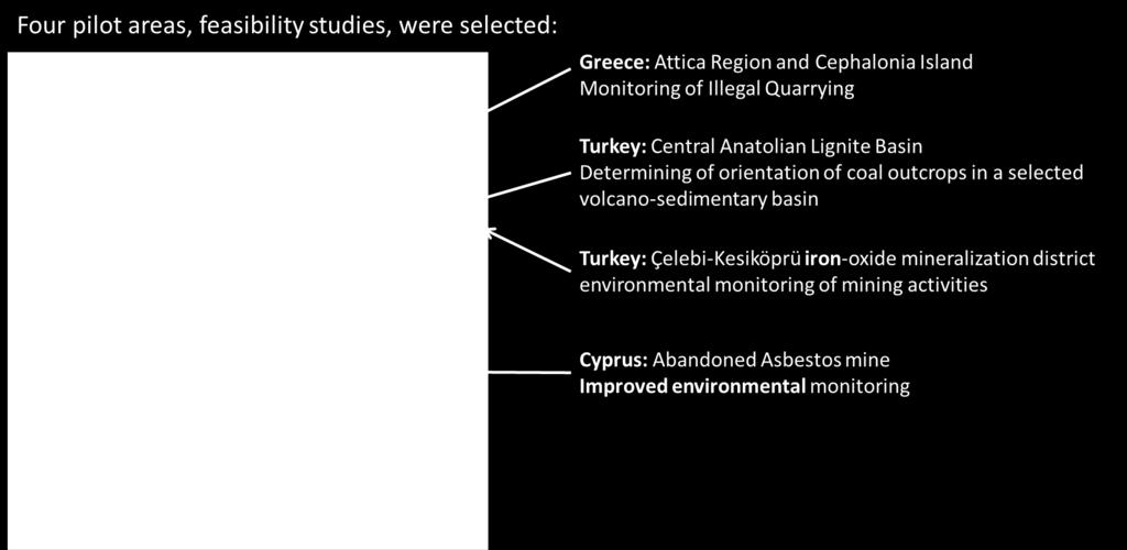
24 H2020 Geo-Cradle project: Greece: Monitoring of illegal Quarrying A tool for the Greek Ministry of Environment and Energy


25 H2020 Geo-Cradle project: Cyprus: Abandoned Asbestos mine Collaboration with the Cyprus GSD-FD-Ministry of Agriculture, Rural Development and Environment: for the restoration of the Asbestos Mine


26 H2020 Geo-Cradle project: Turkey: Iron-oxide mineralization mapping In collaboration with JeoDijital Bilisim Teknoloji Madencilik company (Turkey)


27 H2020 Geo-Cradle project: Turkey: exploring coal deposit potential in Central Anatolian In collaboration with JADE - Association of Geological Researches, Turkey


28 H2020 Geo-Cradle project: Delivering data from the feasibility study through EGDI


29 H2020 Geo-Cradle project: Dissemination activities: Kingdom of Morocco

30 H2020 Geo-Cradle project: Dissemination activities: training in Ethiopia
31 Future perspectives
32 Future perspectives Developping models for quantitative assessment of physical and chemical surface properties (mines, post-mining areas, remediation's) using hyperspectral data as well as satellite data (e.g.,sentinel-2 and EnMap) Building a world-wide mineral/rock/soil reflectance and emissivity libraries: Mine waste spectral libraries Other minerals of the interest Soil spectral libraries Drill core scanning Detection and monitoring of ground instabilities related to active and abandoned mining areas with radar satellite data (Sentinel-1), assessing the vulnerability of exposed urban areas and infrastructures.
33 Future perspectives
34 Thank you! 40 Years Listening to the Beat of the Earth
Copernicus for Raw Materials Workshop
 Copernicus for Raw Materials Workshop Copernicus 40 User Years Forum Listening Industry Workshop, to the Beat 5th September of the Earth 2016, Brussels About http://copernicus.eu/raw-materials-workshop
Introduction of Remote Sensing Methods for Monitoring the Under Restoration Amiantos Mine, Cyprus
 Sixth International Conference on Remote Sensing and Geoinformation of Environment, 26-29 March, 2018 - Cyprus Introduction of Remote Sensing Methods for Monitoring the Under Restoration Amiantos Mine,
OVERALL PROGRAMME. Sunday 16 October 2016:
 Sunday 16 October 2016: OVERALL PROGRAMME - Arrival in Morocco (landing either in Casablanca, with transfers to hotel to be organized by EGS, or Rabat) - Hosted dinner for the European Geological Surveys,
GEO-CRADLE Project Meeting 2 Thursday, 17 th November, 2016
 GEO-CRADLE Project Meeting 2 Thursday, 17 th November, 2016 T4.3 EGS-PGI NRI Marek Graniczny (EGS PGI) Maria Przyłucka (EGS PGI) Eleftheria Poyiadji (EGS-IGME-Greece) Zbigniew Kowalski (EGS PGI) Christodoulos
Addressing GEO-CRADLE regional challenges - Access to raw materials MINUTES
 Observation Activities in the regions of North Africa, Middle East, and Addressing GEO-CRADLE regional challenges - Access to raw materials MINUTES The GEO-CRADLE project has received funding from the
ADVANCED MINERAL MAPPING USING VISIBLE TO NEAR INFRARED, SHORTWAVE AND LONGWAVE INFRARED HIGH SPECTRAL RESOLUTION DATA
 ADVANCED MINERAL MAPPING USING VISIBLE TO NEAR INFRARED, SHORTWAVE AND LONGWAVE INFRARED HIGH SPECTRAL RESOLUTION DATA Veronika Kopačková, Lucie Koucká Overview Concept of our approach, QUANTOOLS into
EuroGeoSurveys An Introduction
 EGS -ASGMI Workshop, Madrid, 2015 EuroGeoSurveys An Introduction 40 Years Listening to the Beat of the Earth Click to edit Master title Albania style EuroGeoSurveys Austria Lithuania Luxembourg Belgium
Change Detection Over Sokolov Open Pit Mine Areas, Czech Republic, Using Multi Temporal HyMAP Data ( )
") Change Detection Over Sokolov Open Pit Mine Areas, Czech Republic, Using Multi Temporal HyMAP Data (2009 2010) S. Adar* a G. Notesco b, A. Brook b, I. Livne b, P. Rojik c, V. Kopackova d, K. Zelenkova
Change Detection Over Sokolov Open Pit Mine Areas, Czech Republic, Using Multi Temporal HyMAP Data (2009 2010) S. Adar* a G. Notesco b, A. Brook b, I. Livne b, P. Rojik c, V. Kopackova d, K. Zelenkova
Call for Applications
 Call for Applications for a PanAfGeo Training «WP1 Geoscientific Mapping, part WP1E1 Remote Sensing» 20-30 November 2017, Bishoftu, Ethiopia in English 1. MAIN CONTEXT OF PANAFGEO PanAfGeo for Pan-African
Eyal Ben-Dor Department of Geography Tel Aviv University
 Spectral Imaging of Soils: past present and future Eyal Ben-Dor Department of Geography Tel Aviv University 2nd International Conference on Airborne Research for the Environment, DLR - the German Aerospace
Towards best practices for using satellite Earth Observation in mining and extractives
 Towards best practices for using satellite Earth Observation in mining and extractives EU-Latin America Mining & Exploration Convention and Trade Show METS 2018 11 April 2018 Madrid Marriott Auditorium
The role of soil spectral library for the food security issue
 The role of soil spectral library for the food security issue Eyal Ben-Dor Department of Geography Tel Aviv University The GEO-CRADLE project has received funding from the European Union s Horizon 2020
EuroGeoSurveys & ASGMI The Geological Surveys of Europe and IberoAmerica
 EuroGeoSurveys & ASGMI The Geological Surveys of Europe and IberoAmerica Geological Surveys, what role? Legal mandate for data & information: Research Collection Management Interpretation/transformation
Proposal on Knowledge Base Projects Sustainability
 Proposal on Knowledge Base Projects Sustainability MIN-GUIDE Policy Laboratory 5: Mining and Mineral Information in the European Union Slavko Solar, EuroGeoSurveys Madrid, May 23-25, 2018 40 Years Listening
Geological information for Europe : Towards a pan-european Geological Data Infrastructure
 Geological information for Europe : Towards a pan-european Geological Data Infrastructure Integrating geoscientific information for EU competitiveness Co-funded by the European Union European societal
EuroGeoSurveys. Minerals, metals and mining statistics: The role of Geological Surveys in building continental-scale official data sets
 EuroGeoSurveys Minerals, metals and mining statistics: The role of Geological Surveys in building continental-scale official data sets 40 Years Listening to the Beat of the Earth 1 EuroGeoSurveys 37 Geological
Land subsidence induced by groundwater extraction in the Alto Guadalentín aquifer, SE Spain.
 Land subsidence induced by groundwater extraction in the Alto Guadalentín aquifer, SE Spain. Pablo Ezquerro, Marta Béjar-Pizarro, Gerardo Herrera, José A. Fernández Merodo, Roberto Tomás, Carolina Guardiola-Albert,
Infrastructure monitoring using SAR interferometry
 Infrastructure monitoring using SAR interferometry Hossein Nahavandchi Roghayeh Shamshiri Norwegian University of Science and Technology (NTNU), Department of Civil and Environmental Engineering Geodesy
EO-MINERS and Minerals 4EU
 GEO-CRADLE pre-kick-off Meeting Friday, 18 th of February, 2016 Veronika Kopačková, Czech Geological Survey EO-MINERS and Minerals 4EU IONIC Centre, 11 Lysiou Street Athens, Greece EO-MINERS (2010-2013)
40 Years Listening to the Beat of the Earth
 EuroGeoSurveys The role of EuroGeoSurveys in Europe-Africa geoscientific cooperation 40 Years Listening to the Beat of the Earth EuroGeoSurveys 32 Albania Lithuania Austria Luxembourg Belgium The Netherlands
Introduction of Remote Sensing Methods for Monitoring the Under Restoration Amiantos Mine, Cyprus
 Introduction of Remote Sensing Methods for Monitoring the Under Restoration Amiantos Mine, Cyprus Eleftheria Poyiadji *a,b, Marianthi Stefouli a,b, Maria Przyłucka b,c, Stanisław Wołkowicz c, Zbigniew
Advancing Geoscientific Capability. Geological Survey of Finland
 Advancing Geoscientific Capability Geological Survey of Finland GTK in brief The Geological Survey of Finland (GTK) is one of the largest European centres of excellence in assessment, research and the
APPLYING SPECTRAL UNMIXING TO DETERMINE SURFACE WATER PARAMETERS IN MINING ENVIRONMENT
 EARSeL eproceedings, Special Issue: 34 th EARSeL Symposium, 2014 41 APPLYING SPECTRAL UNMIXING TO DETERMINE SURFACE WATER PARAMETERS IN MINING ENVIRONMENT Veronika Kopačková 1, and Lenka Hladíková 2 1.
Copernicus for Raw Materials: making the potential fully operational
 Raw Materials Week 2018 12 th November 2018, Le Plaza Hotel, Boulevard Adolphe Max 118-126, 1000 Brussels Copernicus for Raw Materials: making the potential fully operational 1. Nature of the meeting This
Key words: Hyperspectral, imaging, object identification, urban, investigation
 URBAN SENSING BY HYPERSPECTRAL DATA Lanfen ZHENG, Qingxi TONG, Bing ZHANG, Xing LI, Jiangui LIU The Institute of Remote Sensing Applications, Chinese Academy of Sciences P. O. Box 9718, 100101, Beijing,
Alexia Tsouni National Observatory of Athens. Antwerp, 19/09/
 Coordinating and Integrating EO Activities in North Africa, Middle East, and Balkans. Accelerating the Development of Links with Geo/ Geoss/Copernicus and Inspire initiatives Alexia Tsouni National Observatory
A1 - Total Land Use by Mining and Milling topographical footprint
 A. LAND-USE A1 - Total Land Use by Mining and Milling topographical footprint Topographical Footprint: The total areal footprint (2-dimensional) used by the mine/mill is an overarching proxy for a variety
GeoERA Raw Materials Mineral Intelligence for Europe (MINTELL4EU)
") GeoERA Raw Materials Mineral Intelligence for Europe (MINTELL4EU) Improving and sustaining the EURMKB Pedro Delgado Department of Geological Resources Research GEOLOGICAL SURVEY OF SPAIN Horizon 2020 Co-funded
GeoERA Raw Materials Mineral Intelligence for Europe (MINTELL4EU) Improving and sustaining the EURMKB Pedro Delgado Department of Geological Resources Research GEOLOGICAL SURVEY OF SPAIN Horizon 2020 Co-funded
EuroGEOSS Protected Areas Pilot
 EuroGEOSS Protected Areas Pilot Max Craglia European Commission Joint Research Centre Part 1: the present MyNatura2000 Mobile app. Awareness raising & volunteered data collection. Natura2000 covers 18%
GEOMATICS. Shaping our world. A company of
 GEOMATICS Shaping our world A company of OUR EXPERTISE Geomatics Geomatics plays a mayor role in hydropower, land and water resources, urban development, transport & mobility, renewable energy, and infrastructure
Key words: global monitoring, disaster control, coal fires, China
 Remote-sensing GIS based investigations of coal fires in northern China; global monitoring to support the estimation of CO 2 emissions from spontaneous combustion of coal Freek van der Meer, Paul van Dijk,
a national geological survey perspective François ROBIDA BRGM (French Geological Survey)
") a national geological survey perspective François ROBIDA BRGM (French Geological Survey) Pre-Conference Seminar on Socio-Economic Value of Geospatial for National and Regional Development 21 August 2017,
a national geological survey perspective François ROBIDA BRGM (French Geological Survey) Pre-Conference Seminar on Socio-Economic Value of Geospatial for National and Regional Development 21 August 2017,
C o p e r n i c u s a n d W I G O S
 C o p e r n i c u s a n d W I G O S Jean-Noël Thépaut & Mark Dowell 24 October 2017 GEO XIV, Washington DC, 23-28 October 2017 T h e C o p e r n i c u s P r o g r a m m e Copernicus is the European Union
Analysis of mining deformations based on PSInSAR technique case study of the Walbrzych coal mines (Poland)
") Analysis of mining deformations based on PSInSAR technique case study of the Walbrzych coal mines (Poland) Dr. Jan Blachowski, Dr. Wojciech Milczarek Faculty of Geoengineering, Mining and Geology, Wroclaw
Analysis of mining deformations based on PSInSAR technique case study of the Walbrzych coal mines (Poland) Dr. Jan Blachowski, Dr. Wojciech Milczarek Faculty of Geoengineering, Mining and Geology, Wroclaw
Geo-hazard Potential Mapping Using GIS and Artificial Intelligence
 Geo-hazard Potential Mapping Using GIS and Artificial Intelligence Theoretical Background and Uses Case from Namibia Andreas Knobloch 1, Dr Andreas Barth 1, Ellen Dickmayer 1, Israel Hasheela 2, Andreas
National Remote Sensing Center of China. Space Technology for Sustainable Development in China Status, Achievements and Futures.
 National Remote Sensing Center of China Space Technology for Sustainable Development in China Status, Achievements and Futures Jing Li National Remote Sensing Center of China Ministry of Science and Technology,
Applications of Remote Sensing Systems. to MINERAL DEPOSIT DISCOVERY, DEVELOPMENT
 REMS 6022: Term Project Applications of Remote Sensing Systems to MINERAL DEPOSIT DISCOVERY, DEVELOPMENT and RECLAMATION Venessa Bennett OVERVIEW Remote Sensing data extensively used in all aspects of
RADAR BACKSCATTER AND COHERENCE INFORMATION SUPPORTING HIGH QUALITY URBAN MAPPING
 RADAR BACKSCATTER AND COHERENCE INFORMATION SUPPORTING HIGH QUALITY URBAN MAPPING Peter Fischer (1), Zbigniew Perski ( 2), Stefan Wannemacher (1) (1)University of Applied Sciences Trier, Informatics Department,
IDENTIFICATION AND CHANGES OF SUBSIDENCE BASINS CAUSED BY COAL MINING ACTIVITY IN UPPER SILESIA USING SATELLITE INTERFEROMETRIC DATA
 IDENTIFICATION AND CHANGES OF SUBSIDENCE BASINS CAUSED BY COAL MINING ACTIVITY IN UPPER SILESIA USING SATELLITE INTERFEROMETRIC DATA Maria Przyłucka (1), Marek Graniczny (1), Zbigniew Kowalski (1) (1)
Current experiences in the use of satellite information in development aid activities
 Current experiences in the use of satellite information in development aid activities Meeting at ESA/ESRIN in Frascati 16 th of September 2017 #WorldInCommon AGENCE FRANÇAISE DE DÉVELOPPEMENT FRENCH DEVELOPMENT
I&CLC2000 in support to new policy initiatives (INSPIRE, GMES,..)
") I&CLC2000 in support to new policy initiatives (INSPIRE, GMES,..) Manfred Grasserbauer, Director Joint Research Centre Institute for Environment and Sustainability 1 IMAGE 2000 European mosaic of satellite
I&CLC2000 in support to new policy initiatives (INSPIRE, GMES,..) Manfred Grasserbauer, Director Joint Research Centre Institute for Environment and Sustainability 1 IMAGE 2000 European mosaic of satellite
INSTITUTE OF GEOLOGY AND MINERAL EXPLORATION (I.G.M.E.)
") INSTITUTE OF GEOLOGY AND MINERAL EXPLORATION (I.G.M.E.) PERSPECTIVES FOR THE PRODUCTION OF INDUSTRIAL MINERALS FROM THE EXPLOITATION OF THE WASTE STEMMING DURING THE EXTRACTION OF GREEK WHITE CALCITIC
INSTITUTE OF GEOLOGY AND MINERAL EXPLORATION (I.G.M.E.) PERSPECTIVES FOR THE PRODUCTION OF INDUSTRIAL MINERALS FROM THE EXPLOITATION OF THE WASTE STEMMING DURING THE EXTRACTION OF GREEK WHITE CALCITIC
Remote Sensing and EO activities at the University of Turku
 Remote Sensing and EO activities at the University of Turku Niina Käyhkö Associate Professor Department of Geography and Geology GEO meeting/syke May 23rd, 2018 Geospatial competence at the University
BIM and INSPIRE, for a better integration of built infrastructures in their environment : the MINnD project
 BIM and INSPIRE, for a better integration of built infrastructures in their environment : the MINnD project François ROBIDA Christophe CASTAING Strasbourg, > 1 8 septembre 2017 ABOUT BIM Building Information
EO4SEE - THE PATHFINDER OF OPERATIONAL SATELLITE MONITORING FOR THE REGION OF THE BLACK SEA AND CENTRAL EUROPE
 EO4SEE: Pathfinder assessment for regional high volume data access, processing and information service delivery platforms - South East Region EO4SEE - THE PATHFINDER OF OPERATIONAL SATELLITE MONITORING
sentinel-2 COLOUR VISION FOR COPERNICUS
 sentinel-2 COLOUR VISION FOR COPERNICUS SATELLITES TO SERVE By providing a set of key information services for a wide range of practical applications, Europe s Copernicus programme is providing a step
Geological Mapping Using EO Data for Onshore O&G Exploration
 Geological Mapping Using EO Data for Onshore O&G Exploration Michael Hall ESA Oil and Gas Workshop, Frascati, Italy michael.hall@infoterra-global.com Why use EO data for Geological Mapping? Availability
Future perspectives for EO in Development
 Future perspectives for EO in Development Meeting at ESA/ESRIN in Frascati 11 th of September 2018 #WorldInCommon AGENCE FRANÇAISE DE DÉVELOPPEMENT FRENCH DEVELOPMENT AGENCY 01. What is AFD? France s international
EO-MINERS. Contribution of Earth Observation in monitoring the environmental and societal impact of mining. The EO-MINERS project
 EO-MINERS Contribution of Earth Observation in monitoring the environmental and societal impact of mining The EO-MINERS project Geospatial World Forum Amsterdam April 25, 2012 Stéphane CHEVREL Project
Integrating geology in reality mesh? François ROBIDA BRGM (French Geological Survey)
") Integrating geology in reality mesh? François ROBIDA BRGM (French Geological Survey) > 1 UNDERSTANDING geological phenomena and associated risks. THE FRENCH GEOLOGICAL SURVEY THE BRGM IS FRANCE S LEADING
Integrating geology in reality mesh? François ROBIDA BRGM (French Geological Survey) > 1 UNDERSTANDING geological phenomena and associated risks. THE FRENCH GEOLOGICAL SURVEY THE BRGM IS FRANCE S LEADING
GEOSENSE - GEOLOGICAL MAPPING
 GEOSENSE - GEOLOGICAL MAPPING Whatever the terrain you re working in (from desert to arctic to tropical jungle), whatever the tectonic setting, Geosense has undertaken geological mapping in similar regions.
The Future of Remote Sensing
 The Future of Remote Sensing BELSPO - 30 Years of Remote Sensing Research 17 September 2015, Brussels Research and Michael Berger Earth Observation Sector Directorate Climate Action and Resource Efficiency
Urban areas & climate change
 Urban areas & climate change Paolo Gamba University of Pavia University of Pavia The UNIPV TLC & RS Lab is a dynamic research group developing in the past years many techniques devoted to the analysis
GEO-VIII November Geohazard Supersites and Natural Laboratories Progress Report. Document 9
 GEO-VIII 16-17 November 2011 Geohazard Supersites and Natural Laboratories Progress Report Document 9 This document is submitted to GEO-VIII for information. Geohazard Supersites and Natural Laboratories
A century of experience: Training and knowledge transfer in Africa 30 years of activities: Past, present and future
 Royal Museum for central Africa A century of experience:1898-2012 Training and knowledge transfer in Africa 30 years of activities: Past, present and future Earth Sciences Field Geology Geodynamics Major
EO, Land Motion and Climate Adaptation in Mediterranean Cities June 2014, Athens
 EO, Land Motion and Climate Adaptation in Mediterranean Cities 10-11 June 2014, Athens 1 Context UN Report: Water and Cities Facts and Figures 2 Context UN Report: Water and Cities Facts and Figures 3
Land Administration and Cadastre
 Geomatics play a major role in hydropower, land and water resources and other infrastructure projects. Lahmeyer International s (LI) worldwide projects require a wide range of approaches to the integration
Ramani Geosystems. Putting Africa On The Map. Authorized Resellers
 Ramani Geosystems Putting Africa On The Map Authorized Resellers Ramani Profile Started in 1999 Aerial, Land Surveying & Mapping Solutions + 10 Countries in the region + 80 Staff working in projects Asset
THE FEASIBILITY AND APPLICATION OF PSI TO DETECT A RANGE OF GROUND AND STRUCTURE MOTION PHENOMENA.
 THE FEASIBILITY AND APPLICATION OF PSI TO DETECT A RANGE OF GROUND AND STRUCTURE MOTION PHENOMENA. Rachel Holley, InSAR Surveying Consultant InSAR Surveying Team Fugro NPA Satellite Mapping Introduction
GMES-based Geoservices for Mining Areas
 GMES-based Geoservices for Mining Areas Dr. Andreas Müterthies EFTAS Fernerkundung GmbH Oststraße 2-18 48145 Münster Das Projekt wird unterstützt aus Mitteln der EU und des Landes Nordrhein-Westfalen This
Land Cover and Asset Mapping Operational Change Detection
 Land Cover and Asset Mapping Operational Change Detection Andreas Müller DLR DFD with the support of Charly Kaufmann, Allan Nielsen, Juliane Huth ESA Oil & Gas Workshop, 13-14 September 2010 Folie 1 TWOPAC
Applications of Geomatics in Surface Mining
 IOP Conference Series: Earth and Environmental Science PAPER OPEN ACCESS Applications of Geomatics in Surface Mining To cite this article: Jan Blachowski et al 2017 IOP Conf. Ser.: Earth Environ. Sci.
Urban Mapping. Sebastian van der Linden, Akpona Okujeni, Franz Schug 11/09/2018
 Urban Mapping Sebastian van der Linden, Akpona Okujeni, Franz Schug 11/09/2018 Introduction to urban remote sensing Introduction The urban millennium Source: United Nations, 2014 Urban areas mark extremes
OSS MISSION.
 GEO-CRADLE COORDINATING AND INTEGRATING STATE-OF-THE-ART EARTH OBSERVATION ACTIVITIES IN THE REGION OF NORTH OF AFRICA, MIDDLE EAST, AND BALKANS AND DEVELOPING LINKS WITH GEO RELATED INITIATIVES TOWARD
MINISTRY OF NATURAL RESOURCES AND ENVIRONMENT Vietnam Institute of Geosciences and Mineral Resources (VIGMR)
") MINISTRY OF NATURAL RESOURCES AND ENVIRONMENT (VIGMR) Nguyen Quoc Dinh Representative of VIGMR to Sentinel Asia Awaji, Japan, November 1 st,2018 CONTENTS INTRODUCTION TO VIGMR COOPERATION and CONTRIBUTION
MINISTRY OF NATURAL RESOURCES AND ENVIRONMENT (VIGMR) Nguyen Quoc Dinh Representative of VIGMR to Sentinel Asia Awaji, Japan, November 1 st,2018 CONTENTS INTRODUCTION TO VIGMR COOPERATION and CONTRIBUTION
Spaceborne radar applications in Geology
 216 051 ESATM-17 December 2005 Spaceborne radar applications in Geology An introduction to imaging radar, and application examples of ERS SAR in Geology and Geomorphology European Spate Agency Agente spatiale
EUMETSAT Satellite Status
 EUMETSAT Satellite Status Dr. K. Dieter Klaes EUMETSAT 1 ET-SAT Meeting 4-6 April 2017, WMO, Geneva, Switzerland EUMETSAT is an intergovernmental organisation with 30 Member States and 1 Cooperating State
Current LCLUC challenges in SCERIN: Assessing Ecosystem Function and Processes
 Summary of the SCERIN 2 meeting Current LCLUC challenges in SCERIN: Assessing Ecosystem Function and Processes Katarzyna Ostapowicz Department of GIS, Cartography and Remote Sensing, Institute of Geography
Excel Geomatics: Offering Excellence with Unique Consultancy & Services
 Excel Geomatics: Offering Excellence with Unique Consultancy & Services Providing consultancy and value Added Services using Remote Sensing, Photogrammetry and LiDAR in areas such as Agriculture, Forestry,
Towards eenvironment Prague, March GMES Space Component. Josef Aschbacher Head, ESA GMES Space Office
 Towards eenvironment Prague, 25-27 March 2009 GMES Space Component Josef Aschbacher Head, ESA GMES Space Office Prague from Space Segment 2 05 Nov 2003 CNES 2003 GISAT 2007 ESA GSELAND GMES is an EU led
Arctic Observing Systems Challenges, New opportunities and Integration
 Arctic Observing Systems Challenges, New opportunities and Integration Japan Norway Arctic Science Week 03 June 2016 By Stein Sandven, NERSC Building an integrated Arctic Observing System Need to collect,
Hyper-Spectral and Copernicus Evolution
 Hyper-Spectral and Copernicus Evolution Antonio Ciccolella - ESA Roma, 1 March 2017 Issue/Revision: 0.0 Reference: ESA UNCLASSIFIED Status: - For Official Use ESA UNCLASSIFIED - For Official Use Hyperspectral
Spectroscopy-supported digital soil mapping
 Spectroscopy-supported digital soil mapping Outline Introduction Project and theoretical background Field sampling Estimating and mapping soil mineralogy Conclusion & outlook The nation that destroys its
Development of Geospatial Information in Indonesia: Progress & Challenge
 Development of Geospatial Information in Indonesia: Progress & Challenge Dr. Nurwadjedi Sarbini Deputy of Thematic Geospatial Information Geospatial Information Agency (BIG) Geosmart Asia, September 29
Geological Survey of Canada Lands and Minerals Sector Natural Resources Canada OneGeology, June 2018
 Geological Survey of Canada Lands and Minerals Sector Natural Resources Canada OneGeology, June 2018 Geological Survey of Canada Mission The Geological Survey of Canada provides public geoscience knowledge
Earth and Environmental Science (EES)
") Earth and Environmental Science (EES) 1 Earth and Environmental Science (EES) Courses EES 5011. Remote Sensing and GIS. 4 Credit Hours. The focus of this class is on remote sensing technologies and geographic
Earth and Environmental Science (EES) 1 Earth and Environmental Science (EES) Courses EES 5011. Remote Sensing and GIS. 4 Credit Hours. The focus of this class is on remote sensing technologies and geographic
Preparatory Site Report (PSR)
") Preparatory Site Report (PSR) ACTIVITY 3.2 ILLEGAL QUARRYING CASE STUDY: LAKKA QUARRY CCaase Municipality of Kyrros, Prefecture of Pella, Region of Central Macedonia AUTHORS: Chatzipanagis Ioannis, Geologist,
Preparatory Site Report (PSR) ACTIVITY 3.2 ILLEGAL QUARRYING CASE STUDY: LAKKA QUARRY CCaase Municipality of Kyrros, Prefecture of Pella, Region of Central Macedonia AUTHORS: Chatzipanagis Ioannis, Geologist,
Cristina Ananasso Copernicus Unit DG GROW. H2020 Space: Calls on Earth Observation and Copernicus Ilan Ramon Conference 28/01/2018 Tel Aviv
 Cristina Ananasso Copernicus Unit DG GROW H2020 Space: Calls on Earth Observation and Copernicus Ilan Ramon Conference 28/01/2018 Tel Aviv OUTLINE Call Space 2018-2020 - Earth Observation and Copernicus
Satellite Remote Sensing for Ocean
 Satellite Remote Sensing for Ocean August 17, 2017 Masatoshi Kamei RESTEC All rights reserved RESTEC 2015 Contents 1. About RESTEC and Remote Sensing 2. Example of Remote Sensing Technology 3. Remote Sensing
The Joint Programming Initiative on Cultural Heritage (JPICH): European perspective
: European perspective") COPERNICUS FOR CULTURAL HERITAGE Copernicus User Forum Industry Workshop Brussels, 24 April 2017 The Joint Programming Initiative on Cultural Heritage (JPICH): European perspective Cristina Sabbioni CNR,
COPERNICUS FOR CULTURAL HERITAGE Copernicus User Forum Industry Workshop Brussels, 24 April 2017 The Joint Programming Initiative on Cultural Heritage (JPICH): European perspective Cristina Sabbioni CNR,
EuroGeoSource project
 3/18/2011 Stephan Gruijters, coordinator Euro Geo Source EuroGeoSource project -WP4- Harmonisation of the georesources attributes and the data exchange format Jasna Šinigoj, Duška Rokavec Geological Survey
Alteration zone Mapping in the Meiduk and Sar Cheshmeh Porphyry Copper Mining Districts of Iran using Advanced Land Imager (ALI) Satellite Data
 Satellite Data") Alteration zone Mapping in the Meiduk and Sar Cheshmeh Porphyry Copper Mining Districts of Iran using Advanced Land Imager (ALI) Satellite Data Amin Beiranvand Pour*, Mazlan Hashim Geoscience and Digital
Alteration zone Mapping in the Meiduk and Sar Cheshmeh Porphyry Copper Mining Districts of Iran using Advanced Land Imager (ALI) Satellite Data Amin Beiranvand Pour*, Mazlan Hashim Geoscience and Digital
HYPERSPECTRAL IMAGING
 1 HYPERSPECTRAL IMAGING Lecture 9 Multispectral Vs. Hyperspectral 2 The term hyperspectral usually refers to an instrument whose spectral bands are constrained to the region of solar illumination, i.e.,
Land Use and Land cover statistics (LUCAS)
") EUROPEAN COMMISSION EUROSTAT Directorate E: Sectoral and regional statistics Doc. ENV/DIMESA/7.1/2012 Original in EN Agenda point 7.1 Land Use and Land cover statistics (LUCAS) DIMESA Directors' Meeting
EUROPEAN COMMISSION EUROSTAT Directorate E: Sectoral and regional statistics Doc. ENV/DIMESA/7.1/2012 Original in EN Agenda point 7.1 Land Use and Land cover statistics (LUCAS) DIMESA Directors' Meeting
URBAN MAPPING AND CHANGE DETECTION
 URBAN MAPPING AND CHANGE DETECTION Sebastian van der Linden with contributions from Akpona Okujeni Humboldt-Unveristät zu Berlin, Germany Introduction Introduction The urban millennium Source: United Nations,
LANDSLIDE IDENTIFICATION, MOVEMENT MONITORING AND RISK ASSESSMENT USING ADVANCED EARTH OBSERVATION TECHNIQUES
 LANDSLIDE IDENTIFICATION, MOVEMENT MONITORING AND RISK ASSESSMENT USING ADVANCED EARTH OBSERVATION TECHNIQUES European Leader Investigator Dr. Zbigniew Perski Carpathian Branch, Polish Geological Institute
WHAT IS MINERAL EXPLORATION?
 INDABA PRESENTATION CAPE TOWN FEBRUARY 2017 AIM:SAV WHAT IS MINERAL EXPLORATION? AIM:SAV What is mineral exploration? 2 Exploration is the term used to describe a wide range of activities aimed at searching
The Safeland Project General Overview and Monitoring Technology Development
 Ber. Geol. B. A., 82, ISSN 1017 8880 Landslide Monitoring Technologies & Early Warning Systems The Safeland Project General Overview and Monitoring Technology Development The SafeLand Consortium a), N.
IAEG SDGs WG GI, , Mexico City
 IAEG SDGs WG GI, 12-14.12.2016, Mexico City UN-GGIM:Europe s perspective and activities to support better integration of geospatial information and statistics and the UN SDG monitoring Pier-Giorgio Zaccheddu,
GLOBAL NETWORK OF NATIONAL GEOPARKS. Patrick J Mc Keever
 Patrick J Mc Keever A GEOPARK is an area with. geological heritage of international significance but also with. a sustainable development strategy or plan involving local communities. IS A GEOPARK JUST
Czech Geological Survey Remote sensing unit
 Czech Geological Survey Remote sensing unit CGS Remote sensing unit Who we are? Part of the Dpt. of Regional geology of crystalline complexes Since 2005 Processing of satellite and airborne data Geoinformation
Hyperspectral Data as a Tool for Mineral Exploration
 1 Hyperspectral Data as a Tool for Mineral Exploration Nahid Kavoosi, PhD candidate of remote sensing kavoosyn@yahoo.com Nahid Kavoosi Abstract In Geology a lot of minerals and rocks have characteristic
Engineering Geology at University Complutense of Madrid: 30 years of postgraduate courses
 FIRST INTERNATIONAL CONFERENCE on EDUCATION and TRAINING in GEO-ENGINEERING ENGINEERING SCIENCES Constantza, Romania - June 2008 Engineering Geology at University Complutense of Madrid: 30 years of postgraduate
Positional accuracy of the drainage networks extracted from ASTER and SRTM for the Gorongosa National Park region - Comparative analysis
 Positional accuracy of the drainage networks extracted from ASTER and SRTM for the Gorongosa National Park region - Comparative analysis Tiago CARMO 1, Cidália C. FONTE 1,2 1 Departamento de Matemática,
Copernicus Opportunities and Challenges in Europe s eyes on Earth
 Copernicus Opportunities and Challenges in Europe s eyes on Earth Gunter Schreier Deputy Director DLR German Remote Sensing Data Center - Earth Observation Center Rotterdam 25. Mai 2016 Sentinel - Missions
Copernicus Today and Tomorrow GEO Week Group on Earth Observation Geneva, 16 January 2014 The Copernicus Space Infrastructure
 Copernicus Today and Tomorrow GEO Week Group on Earth Observation Geneva, 16 January 2014 The Copernicus Space Infrastructure Thomas Beer, Policy Coordinator, Copernicus Space Office, ESA-ESRIN, Frascati
Urban Mapping & Change Detection. Sebastian van der Linden Humboldt-Universität zu Berlin, Germany
 Urban Mapping & Change Detection Sebastian van der Linden Humboldt-Universität zu Berlin, Germany Introduction - The urban millennium Source: United Nations Introduction Text Source: Google Earth Introduction
GEO-CRADLE Regional Event Access to raw materials. Veronika Kopačková, Czech Geological Survey EO-MINERS
 GEO-CRADLE Regional Event Access to raw materials Veronika Kopačková, Czech Geological Survey EO-MINERS Morocco&Algeria 17-23 October 2016 EO-MINERS (2010-2013) EO-MINERS was a Research and Technological
Copernicus the European Space Programme for Earth Observation
 Copernicus the European Space Programme for Earth Observation http://www.copernicus.eu http://www.esa.int An Introduction Rome 2017 by Giorgio Bagnasco Issue/Revision: 0.0 Reference: ESA UNCLASSIFIED Status:
EU collaborations with NASA LCLUC Program & Current Priorities
 & Current Priorities ioannis Manakos, Dr. Centre for Research and Technology Hellas Information Technologies Institute Visual Analytics, Virtual & Augmented Reality Laboratory European Association of Remote