High-resolution temporal imaging of. Howard Zebker
|
|
|
- Agnes Atkins
- 5 years ago
- Views:
Transcription
1 High-resolution temporal imaging of crustal deformation using InSAR Howard Zebker Stanford University

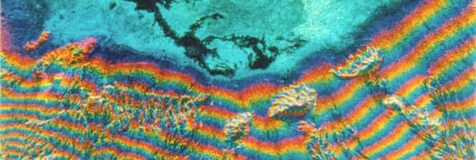
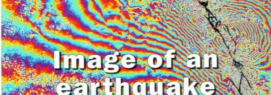
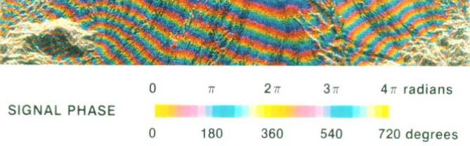
2 InSAR Prehistory SEASAT Topographic Fringes SEASAT Deformation ERS Earthquake Image Accurate imaging of cumulative deformation and surface topography


3 InSAR Classical Period Volcano deformation, Galapagos IIce flow fl in i Antarctica Earthquake displacement and slip, Hector Mine 1999 event
4 Classical InSAR Characteristics Exploit dense spatial sampling of cumulative deformation fields Measure static displacements of major events Visualize displacements and average velocities Solve for slip distributions along faults Compute moment magnitudes of earthquakes Constrain magma chamber geometries Cryospheric, hydrologic, landslide, other uses Limitations Large displacements (big earthquakes, volcano inflation) only as atmosphere contributes cm level errors Decorrelation, esp. in vegetated areas Temporal data acquisition generally sparse, maybe only 2 or 3 SAR scenes for any area available


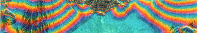
5 Atmosphere limits Variation of water vapor in troposphere gives cm level errors throughout image Atmospheric signature of cold front moving across Netherlands Hanssen et al., Science, 1999

 Long Valley")
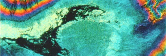
6 Decorrelation limits Areal coverage limited to areas with high correlation, often fails in vegetated regions Correla ation (orange = high) Long Valley caldera Phase
7 Modern era InSAR: We are heading toward time series analysis Current research and future is time series methods - Persistent scatterers - Small baseline subset analysis - Many yet to come Enables temporal analysis, observation of new phenomena, reveals previously unknown or poorly characterized processes Increases sensitivity by minimizing atmosphere and other phase contaminating terms Requires consistent data acquisition

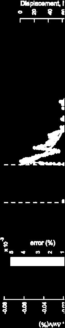
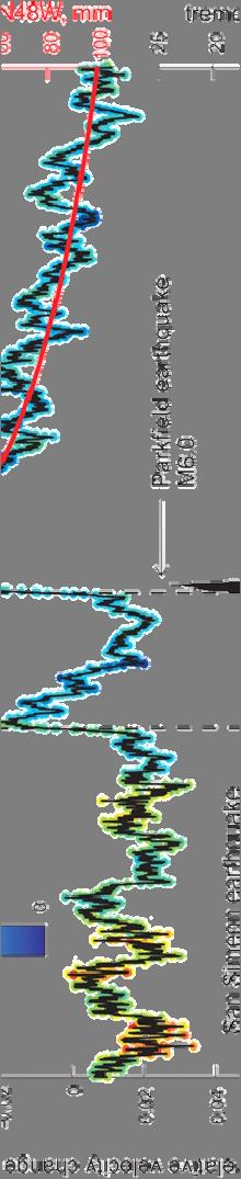
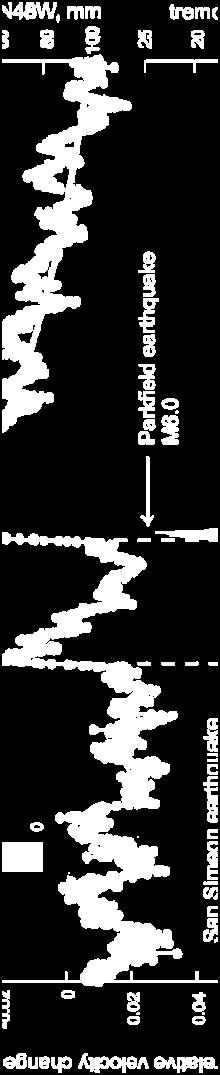
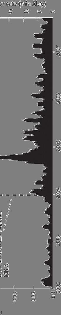
8 GPS crustal deformation time dependence insights Langbein et al., SRL 2005 Brenguier et al., Science 2008 Static deformation map Parkfield, CA GPS temporal displacements (red) plus other data sources, Parkfield, CA


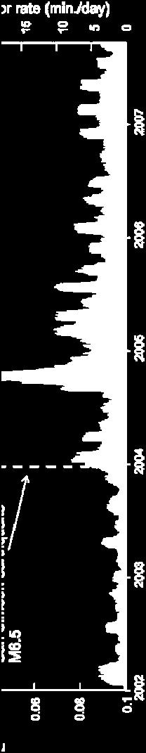
9 Aseismic activity important unappreciated stress transfer Time scales days to months Too slow for seismic signals, too local for tectonic observations Maybe ubiquitous around Earth Segall et al., Nature 2006


10 InSAR time series: persistent scatterers Distributed Single point Dominant scatterer scatterer scatterer Pixel phase 2π Acquisition Find the pixels with stable phase over many observations


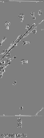
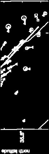
11 PS selection methods SFO airport Permanent scatterers amplitude dispersion Ferretti et al., 2000 San Andreas Fault Pixel phase and filtering Hooper, 2004 Maximum likelihood Shanker and Zebker, 2007 Range change rate (mm/yr) -6 5


 0-20")
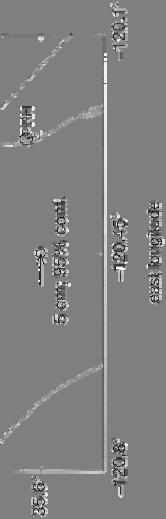
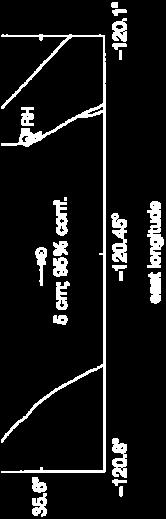
12 PS observations of central San Andreas fault A Fault profile Line of sight rate (mm/yr) A -2 A A Average Line of sight Displacement (mm)
13 InSAR timeseries: small baselinesubset subset (SBAS) Time-baseline relations Mean coherence image Find regions with high correlation over many observations
14 SBAS analysis of Long Valley, CA Temporal evolution of resurgent dome Tizzani et al., RSE 2007 Mean velocities Dome growth and subsidence with time
15 SBAS reduction of CSAF region at C band San Andreas Fault Range Rate (mm/yr) PS coverage region -10
16 Resolution requirement for more PS points Prefer PS point density ~ m spatially Fine resolution helps in two ways -For constant probability of PS, more pixels in same geographic area yield more PS -Finer resolution makes it easier for a single scatterer to dominate Resolution probably needs to be in the m scale need Resolution probably needs to be in the m-scale, need a better analytical model incorporating scattering and scatterer distribution
17 Phase unwrapping for PS analysis remains a problem Example existing methods - STUN algorithm from Delft - 3D unwrapping algorithms by Hooper and Zebker Current research - Minimum cost flow extension to 3D - Edge-based methods - Incorporation of external constraints
18 Edgelist phase unwrapping method Interferogram 2 phases φ j Time stack Method: -Solve for n i, missing cycles for each measurement φ i φ i - Minimize Interferogram 1 Each edge has a weight w ik and a flow f ik Σ w ik f ik - Subject to constraint n i -n k = [φ i - φ k ]/2π + f ik φ k Rectangular facets in time, triangular facets in space Additional constraints such as GPS points easily added by including more equations of same form
19 Enabling future sensors and systems Frequent, reliable and robust data acquisition Longer sequences facilitate PS identification Multiple measurements reduce atmosphere phase Fine resolution yields more PS points as smaller scattererscan can dominate Longer wavelengths to improve correlation Controlled orbits to manage baselines, precise orbit determination ti 3D phase unwrapping: time series displacements still limited by phase unwrapping algorithms Technology wish list: short repeats, long wavelength, fine resolution, precise orbits, processing codes
20 Summary Time series InSAR invites significant new scientific investigations Known phenomena characterized by temporal effects and interactions Many new processes may be hiding in unobserved parts of time spectrum Conventional applications extended ddto challenging hll vegetated and other extreme terrain Accuracy much higher than present methods Time series of displacements today limited by phase unwrapping algorithms and lack of temporal data
to: Interseismic strain accumulation and the earthquake potential on the southern San
 Supplementary material to: Interseismic strain accumulation and the earthquake potential on the southern San Andreas fault system by Yuri Fialko Methods The San Bernardino-Coachella Valley segment of the
SAR interferometry Status and future directions. Rüdiger Gens
 SAR interferometry Status and future directions Rüdiger Gens Polarimetric InSAR Polarimetric InSAR InSAR - Status and future directions sensitivity to changes in surface scattering, even in the presence
Noise covariance model for time-series InSAR analysis. Piyush Agram, Mark Simons
 Noise covariance model for time-series InSAR analysis Piyush Agram, Mark Simons Motivation Noise covariance in individual interferograms has been well studied. (Hanssen, 2001) Extend the noise model to
Deformation measurement using SAR interferometry: quantitative aspects
 Deformation measurement using SAR interferometry: quantitative aspects Michele Crosetto (1), Erlinda Biescas (1), Ismael Fernández (1), Ivan Torrobella (1), Bruno Crippa (2) (1) (2) Institute of Geomatics,
MODELING INTERFEROGRAM STACKS FOR SENTINEL - 1
 MODELING INTERFEROGRAM STACKS FOR SENTINEL - 1 Fabio Rocca (1) (1) Politecnico di Milano, Via Ponzio 34/5, 20133 Milano, Italy, Email: rocca@elet.polimi.it ABSTRACT The dispersion of the optimal estimate
DIFFERENTIAL INSAR STUDIES IN THE BOREAL FOREST ZONE IN FINLAND
 DIFFERENTIAL INSAR STUDIES IN THE BOREAL FOREST ZONE IN FINLAND Kirsi Karila (1,2), Mika Karjalainen (1), Juha Hyyppä (1) (1) Finnish Geodetic Institute, P.O. Box 15, FIN-02431 Masala, Finland, Email:
ALOS PI Symposium 2009, 9-13 Nov 2009 Hawaii MOTION MONITORING FOR ETNA USING ALOS PALSAR TIME SERIES
 ALOS PI Symposium 2009, 9-13 Nov 2009 Hawaii ALOS Data Nodes: ALOS RA-094 and RA-175 (JAXA) MOTION MONITORING FOR ETNA USING ALOS PALSAR TIME SERIES Urs Wegmüller, Charles Werner and Maurizio Santoro Gamma
Slow Deformation of Mt. Baekdu Stratovolcano Observed by Satellite Radar Interferometry
 Slow Deformation of Mt. Baekdu Stratovolcano Observed by Satellite Radar Interferometry Sang-Wan Kim and Joong-Sun Won Department of Earth System Sciences, Yonsei University 134 Shinchon-dong, Seodaemun-gu,
MEASURING VOLCANIC DEFORMATION AT UNIMAK ISLAND FROM 2003 TO 2010 USING
 MEASURING VOLCANIC DEFORMATION AT UNIMAK ISLAND FROM 2003 TO 2010 USING WEATHER MODEL-ASSISTED TIME SERIES INSAR Gong, W. a, Meyer, F. J. a, Lee, C. W. b, Lu, Z. c, Freymueller, J a. a. Geophysical Institute,
Radar Remote Sensing: Monitoring Ground Deformations and Geohazards from Space
 Radar Remote Sensing: Monitoring Ground Deformations and Geohazards from Space Xiaoli Ding Department of Land Surveying and Geo-Informatics The Hong Kong Polytechnic University A Question 100 km 100 km
Journal of Geodynamics
 Journal of Geodynamics 49 (2010) 161 170 Contents lists available at ScienceDirect Journal of Geodynamics journal homepage: http://www.elsevier.com/locate/jog Recent advances on surface ground deformation
Geodesy (InSAR, GPS, Gravity) and Big Earthquakes
 and Big Earthquakes") Geodesy (InSAR, GPS, Gravity) and Big Earthquakes Mathew Pritchard Teh-Ru A. Song Yuri Fialko Luis Rivera Mark Simons UJNR Earthquake Research Panel, Morioka, Japan - Nov 6, 2002 Goals Accurate and high
Geodesy (InSAR, GPS, Gravity) and Big Earthquakes Mathew Pritchard Teh-Ru A. Song Yuri Fialko Luis Rivera Mark Simons UJNR Earthquake Research Panel, Morioka, Japan - Nov 6, 2002 Goals Accurate and high
Subsidence-induced fault
 Surveying Monitoring underground coal mining-induced subsidence by Yaobin Sheng, Linlin Ge, Chris Rizos, University of New South Wales, and Yunjia Wang, China University of Mining and Technology This paper
PSI Precision, accuracy and validation aspects
 PSI Precision, accuracy and validation aspects Urs Wegmüller Gamma Remote Sensing AG, Gümligen, Switzerland, wegmuller@gamma-rs.ch Contents - Precision - Accuracy - Systematic errors - Atmospheric effects
Ground displacement in a fault zone in the presence of asperities
 BOLLETTINO DI GEOFISICA TEORICA ED APPLICATA VOL. 40, N. 2, pp. 95-110; JUNE 2000 Ground displacement in a fault zone in the presence of asperities S. SANTINI (1),A.PIOMBO (2) and M. DRAGONI (2) (1) Istituto
Advanced interpretation of land subsidence by validating multiinterferometric SAR data: the case study of Anthemountas basin (Northern Greece)
") Revision of paper Advanced interpretation of land subsidence by validating multiinterferometric SAR data: the case study of Anthemountas basin (Northern Greece) By Raspini et al. General comments This
Revision of paper Advanced interpretation of land subsidence by validating multiinterferometric SAR data: the case study of Anthemountas basin (Northern Greece) By Raspini et al. General comments This
RADAR TIME SERIES ANALYSIS OVER WEST ANATOLIA
 RADAR TIME SERIES ANALYSIS OVER WEST ANATOLIA Mahmut Arıkan, Andrew Hooper, and Ramon Hanssen Delft Institute of Earth Observation and Space Systems (DEOS), Delft University of Technology, Kluyverweg 1,
Ground surface deformation of L Aquila. earthquake revealed by InSAR time series
 Ground surface deformation of L Aquila earthquake revealed by InSAR time series Reporter: Xiangang Meng Institution: First Crust Monitoring and Application Center, CEA Address: 7 Naihuo Road, Hedong District
The PaTrop Experiment
 Improved estimation of the tropospheric delay component in GNSS and InSAR measurements in the Western Corinth Gulf (Greece), by the use of a highresolution meteorological model: The PaTrop Experiment N.
Implementation of Multi-Temporal InSAR to monitor pumping induced land subsidence in Pingtung Plain, Taiwan
 Implementation of Multi-Temporal InSAR to monitor pumping induced land subsidence in Pingtung Plain, Taiwan Presenter: Oswald Advisor: Chuen-Fa Ni Date: March 09, 2017 Literature Review Pingtung Plain
Basics of the modelling of the ground deformations produced by an earthquake. EO Summer School 2014 Frascati August 13 Pierre Briole
 Basics of the modelling of the ground deformations produced by an earthquake EO Summer School 2014 Frascati August 13 Pierre Briole Content Earthquakes and faults Examples of SAR interferograms of earthquakes
APLICATION OF INSAR TO THE STUDY OF GROUND DEFORMATION IN THE MEXICALI VALLEY, B. C., MEXICO.
 APLICATION OF INSAR TO THE STUDY OF GROUND DEFORMATION IN THE MEXICALI VALLEY, B. C., MEXICO. O. Sarychikhina (1), R. Mellors (2), E. Glowacka (1). (1) Centro de Investigacion Cientifica y Educaccion Superior
GPS and GIS Assisted Radar Interferometry
 GPS and GIS Assisted Radar Interferometry Linlin Ge, Xiaojing Li, Chris Rizos, and Makoto Omura Abstract Error in radar satellite orbit determination is a common problem in radar interferometry (INSAR).
EXTENDING INTERFEROMETRIC SYNTHETIC APERTURE RADAR MEASUREMENTS FROM ONE TO TWO DIMENSIONS
 EXTENDING INTERFEROMETRIC SYNTHETIC APERTURE RADAR MEASUREMENTS FROM ONE TO TWO DIMENSIONS A DISSERTATION SUBMITTED TO THE DEPARTMENT OF GEOPHYSICS AND THE COMMITTEE ON GRADUATE STUDIES OF STANFORD UNIVERSITY
Regional Geodesy. Shimon Wdowinski. MARGINS-RCL Workshop Lithospheric Rupture in the Gulf of California Salton Trough Region. University of Miami
 MARGINS-RCL Workshop Lithospheric Rupture in the Gulf of California Salton Trough Region Regional Geodesy Shimon Wdowinski University of Miami Rowena Lohman, Kim Outerbridge, Tom Rockwell, and Gina Schmalze
The Santorini Inflation Episode, Monitored by InSAR and GPS
 The Santorini Inflation Episode, Monitored by InSAR and GPS Ioannis Papoutsis 1,2, Xanthos Papanikolaou 2, Michael Floyd 3, Kang Hyeun Ji 4, Charalampos Kontoes 1, Demitris Paradissis 2, Demitris Anastasiou
P079 First Results from Spaceborne Radar Interferometry for the Study of Ground Displacements in Urban Areas SUMMARY
 P079 First Results from Spaceborne Radar Interferometry for the Study of Ground Displacements in Urban Areas C.M. Crosetto (Instituto de Geomatica), C.A. Casas (University of Barcelona), R.G. Ranieri (University
Atmospheric Phase Screen (APS) estimation and modeling for radar interferometry
 estimation and modeling for radar interferometry") Atmospheric Phase Screen (APS) estimation and modeling for radar interferometry Ramon Hanssen¹, Alessandro Ferretti², Marco Bianchi², Rossen Grebenitcharsky¹, Frank Kleijer¹, Ayman Elawar¹ ¹ Delft University
Atmospheric Phase Screen (APS) estimation and modeling for radar interferometry Ramon Hanssen¹, Alessandro Ferretti², Marco Bianchi², Rossen Grebenitcharsky¹, Frank Kleijer¹, Ayman Elawar¹ ¹ Delft University
The Potential of High Resolution Satellite Interferometry for Monitoring Enhanced Oil Recovery
 The Potential of High Resolution Satellite Interferometry for Monitoring Enhanced Oil Recovery Urs Wegmüller a Lutz Petrat b Karsten Zimmermann c Issa al Quseimi d 1 Introduction Over the last years land
3D temporal evolution of displacements recorded on Mt. Etna from the 2007 to 2010 through the SISTEM method
 3D temporal evolution of displacements recorded on Mt. Etna from the 2007 to 2010 through the SISTEM method Bonforte A., Guglielmino F.,, Puglisi G. INGV Istituto Nazionale di Gofisica e vulcanologia Osservatorio
NOTES AND CORRESPONDENCE Segmented Faulting Process of Chelungpu Thrust: Implication of SAR Interferograms
 , Vol. 14, No.2, 241-247, June 2003 NOTES AND CORRESPONDENCE Segmented Faulting Process of Chelungpu Thrust: Implication of SAR Interferograms Chien-Chih Chen 1,*, Chung-Pai Chang 2, and Kun-Shan Chen
Ground deformation in Thessaly, Central Greece, between 1992 and 2000 by means of ERS multi-temporal InSAR
 INGV Ground deformation in Thessaly, Central Greece, between 1992 and 2000 by means of ERS multi-temporal InSAR S. Atzori (1), C. Tolomei (1), S. Salvi (1), A. Ganas (2), S. Stramondo (1) and L. Colini
Supplementary information. Analytical Techniques and Measurement Uncertainty
 Supplementary information Analytical Techniques and Measurement Uncertainty Interferomeric SAR (InSAR) allows measurement of millimetre-level surface displacements, including land subsidence, in the radar
Two-pass DInSAR uses an interferometric image pair and an external digital elevation model (DEM). Among the two singlelook complex (SLC) images, one i
. Among the two singlelook complex (SLC) images, one i") DIFFERENTIAL RADAR INTERFEROMETRY AND ITS APPLICATION IN MONITORING UNDERGROUND COAL MINING-INDUCED SUBSIDENCE Yaobin Sheng a, b, c, *, Yunjia Wang a, b, Linlin Ge c, Chris Rizos c a Jiangsu Key Laboratory
DIFFERENTIAL RADAR INTERFEROMETRY AND ITS APPLICATION IN MONITORING UNDERGROUND COAL MINING-INDUCED SUBSIDENCE Yaobin Sheng a, b, c, *, Yunjia Wang a, b, Linlin Ge c, Chris Rizos c a Jiangsu Key Laboratory
Multi-interferogram method for measuring interseismic deformation: Denali Fault, Alaska
 Geophys. J. Int. (27) 17, 1165 1179 doi: 1.1111/j.1365-246X.27.3415.x Multi-interferogram method for measuring interseismic deformation: Denali Fault, Alaska Juliet Biggs, 1 Tim Wright, 2 Zhong Lu 3 and
Surface Deformation Measurements Scientific Requirements & Challenges
 Surface Deformation Measurements Scientific Requirements & Challenges 1st Science and Application Workshop for Germany-Japan Next-Generation SAR M. Eineder, C. Minet, A. Parizzi Tokyo, 27.6.2013 Tandem-L
APPLICABILITY OF PSINSAR FOR BUILDING HAZARD IDENTIFICATION
 APPLICABILITY OF PSINSAR FOR BUILDING HAZARD IDENTIFICATION. STUDY OF THE 29 JANUARY 2006 KATOWICE EXHIBITION HALL COLLAPSE AND THE 24 FEBRUARY 2006 MOSCOW BASMANNY MARKET COLLAPSE Zbigniew Perski (1),
Combining InSAR, Levelling and GNSS for the Estimation of 3D Surface Displacements
 Combining InSAR, Levelling and GNSS for the Estimation of 3D Surface Displacements Thomas Fuhrmann (1), Miguel Caro Cuenca (2), Freek van Leijen (3), Malte Westerhaus (1), Ramon Hanssen (3), Bernhard Heck
Towards Routine Monitoring of Tectonic and Volcanic Deformation with Sentinel-1
 INSARAP Towards Routine Monitoring of Tectonic and Volcanic Deformation with Sentinel-1 Wright, Tim J (1); Biggs, Juliet (2); Crippa, Paula (3); Ebmeier, Susanna K. (2); Elliott, John (4); Gonzalez, Pablo
PERSISTENT SCATTERER SAR INTERFEROMETRY APPLICATIONS ON LANDSLIDES IN CARPATHIANS (SOUTHERN POLAND)
") Acta Geodyn. Geomater., Vol. 7, No. 3 (159), 1 7, 2010 PERSISTENT SCATTERER SAR INTERFEROMETRY APPLICATIONS ON LANDSLIDES IN CARPATHIANS (SOUTHERN POLAND) Zbigniew PERSKI 1) *, Tomasz WOJCIECHOWSKI 1)
Acta Geodyn. Geomater., Vol. 7, No. 3 (159), 1 7, 2010 PERSISTENT SCATTERER SAR INTERFEROMETRY APPLICATIONS ON LANDSLIDES IN CARPATHIANS (SOUTHERN POLAND) Zbigniew PERSKI 1) *, Tomasz WOJCIECHOWSKI 1)
VALIDATION OF THE PERMANENT SCATTERERS TECHNIQUE IN URBAN AREAS
 VALIDATION OF THE PERMANENT SCATTERERS TECHNIQUE IN URBAN AREAS Alessandro Ferretti, Claudio Prati, Fabio Rocca, Carlo Colesanti Dipartimento di Elettonica e Informazione Politecnico di Milano Piazza L.
Landslide Monitoring in Three Gorges Area By Joint Use of Phase Based and Amplitude Based Methods
 Landslide Monitoring in Three Gorges Area By Joint Use of Phase Based and Amplitude Based Methods Xuguo Shi, Lu Zhang, Mingsheng Liao, Timo Balz LIESMARS, Wuhan University Outlines Introduction InSAR Results
estimated by InSAR, and the temporal evolution of the deformation and possible cause.
 QUANTIFICATION OF SUBSIDENCE RATES ASSOCIATED WITH GROUNDWATER FLOW USING SAR INTERFEROMETRY J. Catalao (1), G. Nico (2), V. Conde (1), J.M. Miranda (1) (1) IDL, Universidade Lisboa, Campo Grande, Portugal,
DEFORMATION DUE TO MAGMA MOVEMENT AND ICE UNLOADING AT KATLA VOLCANO, ICELAND, DETECTED BY PERSISTENT SCATTERER INSAR
 DEFORMATION DUE TO MAGMA MOVEMENT AND ICE UNLOADING AT KATLA VOLCANO, ICELAND, DETECTED BY PERSISTENT SCATTERER INSAR Andrew Hooper and Rikke Pedersen Nordic Volcanological Center, Institute of Earth Sciences,
Interferometric Synthetic Aperture Radar (InSAR): Its Past, Present and Future
: Its Past, Present and Future") Interferometric Synthetic Aperture Radar (InSAR): Its Past, Present and Future by Zhong Lu, Ohig Kwoun, and Russell Rykhus Introduction Very simply, interferometric synthetic aperture radar (InSAR) involves
Interferometric Synthetic Aperture Radar (InSAR): Its Past, Present and Future by Zhong Lu, Ohig Kwoun, and Russell Rykhus Introduction Very simply, interferometric synthetic aperture radar (InSAR) involves
POSTSEISMIC DEFORMATION IN SOUTH ICELAND STUDIED USING MULTIPLE ACQUISTION RADAR INTERFEROMETRY
 POSTSEISMIC DEFORMATION IN SOUTH ICELAND STUDIED USING MULTIPLE ACQUISTION RADAR INTERFEROMETRY Sigurjón Jónsson (1), Jörn Hoffmann (2), Thóra Árnadóttir (3) (1) Institute of Geophysics, ETH Zurich, Schafmattstr.
Application of satellite InSAR data for hydrocarbon reservoir monitoring
 Application of satellite InSAR data for hydrocarbon reservoir monitoring A. Tamburini, A. Belson, A. Ferretti, F. Novali TRE Milano, Italy Copyright - Tele-Rilevamento Europa - 2004 Outline SqueeSAR TM
InSAR atmospheric effects over volcanoes - atmospheric modelling and persistent scatterer techniques
 InSAR atmospheric effects over volcanoes - atmospheric modelling and persistent scatterer techniques Rachel Holley 1,2, Geoff Wadge 1, Min Zhu 1, Ian James 3, Peter Clark 4 Changgui Wang 4 1. Environmental
The financial and communal impact of a catastrophe instantiated by. volcanoes endlessly impact on lives and damage expensive infrastructure every
 Chapter 1 Introduction The financial and communal impact of a catastrophe instantiated by geophysical activity is significant. Landslides, subsidence, earthquakes and volcanoes endlessly impact on lives
SURFACE DEFORMATION OF ALPINE TERRAIN DERIVED BY PS-INSAR TECHNIQUE ON THE SIACHEN GLACIER
 SURFACE DEFORMATION OF ALPINE TERRAIN DERIVED BY PS-INSAR TECHNIQUE ON THE SIACHEN GLACIER Junchao Shi and Ling Chang Department of Remote Sensing, Delft University of Technology, the Netherlands. ABSTRACT
27th Seismic Research Review: Ground-Based Nuclear Explosion Monitoring Technologies
 GROUND TRUTH OF AFRICAN AND EASTERN MEDITERRANEAN SHALLOW SEISMICITY USING SAR INTERFEROMETRY AND GIBBS SAMPLING INVERSION Benjamin A. Brooks 1, Francisco Gomez 2, Eric A. Sandvol 2, and Neil Frazer 1
CSK AO project workshop. AO CSK 3655 Continuous subsidence monitoring employing Cosmo-Skymed constellation.
 CSK AO project workshop AO CSK 3655 Continuous subsidence monitoring employing Cosmo-Skymed constellation. Pablo Blanco Sánchez, Roman Arbiol, Fernando Pérez pablo.blanco@icc.cat Roma 8/5/11 Outline Project
Available online at GHGT-9. Detection of surface deformation related with CO 2 injection by DInSAR at In Salah, Algeria
 Available online at www.sciencedirect.com Energy Procedia 100 (2009) (2008) 2177 2184 000 000 Energy Procedia www.elsevier.com/locate/procedia www.elsevier.com/locate/xxx GHGT-9 Detection of surface deformation
InSAR measurements of volcanic deformation at Etna forward modelling of atmospheric errors for interferogram correction
 InSAR measurements of volcanic deformation at Etna forward modelling of atmospheric errors for interferogram correction Rachel Holley, Geoff Wadge, Min Zhu Environmental Systems Science Centre, University
J. Manuel Delgado (1,2), Roberto Cuccu (1), Giancarlo Rivolta (1)
, Roberto Cuccu (1), Giancarlo Rivolta (1)") MONITORING GROUND DEFORMATION USING PERSISTENT SCATTERS INTERFEROMETRY (PSI) AND SMALL BASELINES (SBAS) TECHNIQUES INTEGRATED IN THE ESA RSS SERVICE: THE CASE STUDY OF VALENCIA, ROME AND SOUTH SARDINIA
MONITORING GROUND DEFORMATION USING PERSISTENT SCATTERS INTERFEROMETRY (PSI) AND SMALL BASELINES (SBAS) TECHNIQUES INTEGRATED IN THE ESA RSS SERVICE: THE CASE STUDY OF VALENCIA, ROME AND SOUTH SARDINIA
ERS Track 98 SAR Data and InSAR Pairs Used in the Analysis
 ERS Track 98 SAR Data and InSAR Pairs Used in the Analysis Date 1 Date 2 Date 1 Date 2 Date 1 Date 2 Date 1 Date 2 7/17/1992 6/19/2000 7/17/1992 7/2/1993 9/10/1993 10/28/1996 9/3/1995 10/18/1999 9/25/1992
On the Exploitation of Target Statistics for SAR Interferometry Applications
 On the Exploitation of Target Statistics for SAR Interferometry Applications A. Monti Guarnieri, S. Tebaldini Politecnico di Milano Abstract This paper focuses on multi-image Synthetic Aperture Radar Interferometry
Modeling of Atmospheric Effects on InSAR Measurements With the Method of Stochastic Simulation
 Modeling of Atmospheric Effects on InSAR Measurements With the Method of Stochastic Simulation Z. W. LI, X. L. DING Department of Land Surveying and Geo-Informatics, Hong Kong Polytechnic University, Hung
Inflation of the Aira Caldera (Japan) detected over Kokubu urban area using SAR interferometry ERS data
 detected over Kokubu urban area using SAR interferometry ERS data") Inflation of the Aira Caldera (Japan) detected over Kokubu urban area using SAR interferometry ERS data D. Remy, S. Bonvalot, M. Murakami, P. Briole, S. Okuyama To cite this version: D. Remy, S. Bonvalot,
Inflation of the Aira Caldera (Japan) detected over Kokubu urban area using SAR interferometry ERS data D. Remy, S. Bonvalot, M. Murakami, P. Briole, S. Okuyama To cite this version: D. Remy, S. Bonvalot,
Earthquakes and Faulting
 Earthquakes and Faulting Crustal Strength Profile Quakes happen in the strong, brittle layers Great San Francisco Earthquake April 18, 1906, 5:12 AM Quake lasted about 60 seconds San Francisco was devastated
PERSISTENT SCATTERER INTERFEROMETRY: POTENTIAL AND LIMITS
 PERSISTENT SCATTERER INTERFEROMETRY: POTENTIAL AND LIMITS M. Crosetto a, O. Monserrat a, A. Jungner, B. Crippa b a Institute of Geomatics, Av. del Canal Olímpic, s/n, Castelldefels, E-08860, Spain (michele.crosetto,
Lab 9: Satellite Geodesy (35 points)
") Lab 9: Satellite Geodesy (35 points) Here you will work with GPS Time Series data to explore plate motion and deformation in California. This lab modifies an exercise found here: http://www.unavco.org:8080/cws/pbonucleus/draftresources/sanandreas/
Lab 9: Satellite Geodesy (35 points) Here you will work with GPS Time Series data to explore plate motion and deformation in California. This lab modifies an exercise found here: http://www.unavco.org:8080/cws/pbonucleus/draftresources/sanandreas/
Monitoring long-term ground movements and Deep Seated Gravitational
 Monitoring long-term ground movements and Deep Seated Gravitational Slope Deformations by InSAR time series: cases studies in Italy Salvatore Stramondo (1), M. Saroli (1, 2), M. Moro (1, 2), S. Atzori
Retrieving 3D deformation pattern of a landslide with hiresolution InSAR and in-situ measurements: Just landslide case-study
 Retrieving 3D deformation pattern of a landslide with hiresolution InSAR and in-situ measurements: Just landslide case-study Zbigniew Perski (1), Petar Marinković (2), Yngvar Larsen (3), Tomasz Wojciechowski
Measuring rock glacier surface deformation using SAR interferometry
 Permafrost, Phillips, Springman & Arenson (eds) 2003 Swets & Zeitlinger, Lisse, ISBN 90 5809 582 7 Measuring rock glacier surface deformation using SAR interferometry L.W. Kenyi Institute for Digital Image
GEODETIC ANALYSIS AND MODELLING OF THE SANTORINI VOLCANO, GREECE, FOR THE PERIOD
 GEODETIC ANALYSIS AND MODELLING OF THE SANTORINI VOLCANO, GREECE, FOR THE PERIOD 2012-2015 M. Kaskara (1), S. Atzori (2), I. Papoutsis (1), C. Kontoes (1), S. Salvi (2), A. Ganas (3) (1) National Observatory
The Removal of Lava Flow Subsidence Signals from deformation interferograms at Nyamuragira Volcano, D.R. Congo
 The Removal of Lava Flow Subsidence Signals from deformation interferograms at Nyamuragira Volcano, D.R. Congo Andy Toombs & Geoff Wadge Environmental Systems Science Centre National Centre for Earth Observation
Improved PSI Performance for Landslide Monitoring Applications. J. Duro, R. Iglesias, P. Blanco-Sánchez, F. Sánchez and D. Albiol
 Improved PSI Performance for Landslide Monitoring Applications J. Duro, R. Iglesias, P. Blanco-Sánchez, F. Sánchez and D. Albiol Outline Area of Study Previous PSI (and others) studies Main conclusions
Sentinel-1 IW mode time-series analysis
 Fringe 2015 Workshop Sentinel-1 IW mode time-series analysis When / How / Whether to stitch? Petar Marinkovic Yngvar Larsen PPO.labs Norut Objective Sentinel-1 InSAR for routine and operational monitoring
V. Pinel, A. Hooper, S. de la Cruz-Reyna, G. Reyes-Davila, M.P. Doin
 !"#$%&'(&")*&$*('+,-".'/&(.*0$&'(&"1'&-2".3*&4*5.2-/& 6"+-"'3'02-/'*6 78'9'2-"*9*"0 -/$&&:'0.,- ;'02-/'
Interferometric Synthetic Aperture Radar (InSAR) and GGOS. Andrea Donnellan NASA/JPL February 21, 2007
 and GGOS. Andrea Donnellan NASA/JPL February 21, 2007") Interferometric Synthetic Aperture Radar (InSAR) and GGOS Andrea Donnellan NASA/JPL February 21, 2007 Sources for Science Objectives Fourth component of EarthScope Involvement: NSF, NASA, USGS, Universities
Interferometric Synthetic Aperture Radar (InSAR) and GGOS Andrea Donnellan NASA/JPL February 21, 2007 Sources for Science Objectives Fourth component of EarthScope Involvement: NSF, NASA, USGS, Universities
INGV. Giuseppe Pezzo. Istituto Nazionale di Geofisica e Vulcanologia, CNT, Roma. Sessione 1.1: Terremoti e le loro faglie
 Giuseppe Pezzo Istituto Nazionale di Geofisica e Vulcanologia, CNT, Roma giuseppe.pezzo@ingv.it The study of surface deformation is one of the most important topics to improve the knowledge of the deep
Dr. Simon Plank. German Remote Sensing Data Center (DFD), German Aerospace Center (DLR)
, German Aerospace Center (DLR)") Pre-survey suitability analysis of the differential and persistent scatterer synthetic ti aperture radar interferometry t method for deformation monitoring of landslides Dr. Simon Plank German Remote Sensing
Pre-survey suitability analysis of the differential and persistent scatterer synthetic ti aperture radar interferometry t method for deformation monitoring of landslides Dr. Simon Plank German Remote Sensing
Summaries and Recommendations of the Fringe 2007 Workshop
 Summaries and Recommendations of the Fringe 2007 Workshop The Fringe 2007 summaries and recommendations have been prepared by the session chairpersons and are grouped by session. Methodology: General -
Effect of Unmodelled Reference Frame Motion on InSAR Deformation Estimates
 Effect of Unmodelled Reference Frame Motion on InSAR Deformation Estimates Hermann Bähr 1, Sami Samiei-Esfahany 2 and Ramon Hanssen 2 1 Karlsruhe Institute of Technology, Germany 2 Delft University of
A Quantitative Assessment of DInSAR Measurements of Interseismic Deformation: The Southern San Andreas Fault Case Study
 Pure Appl. Geophys. Ó 2011 Springer Basel AG DOI 10.1007/s00024-011-0403-2 Pure and Applied Geophysics A Quantitative Assessment of DInSAR Measurements of Interseismic Deformation: The Southern San Andreas
Separating Tectonic, Magmatic, Hydrological, and Landslide Signals in GPS Measurements near Lake Tahoe, Nevada-California
 Separating Tectonic, Magmatic, Hydrological, and Landslide Signals in GPS Measurements near Lake Tahoe, Nevada-California Geoffrey Blewitt, Corné Kreemer, William C. Hammond, & Hans-Peter Plag NV Geodetic
PS-INSAR MEASUREMENT OF GROUND SUBSIDENCE IN GRANADA AREA (BETIC CORDILLERA, SPAIN)
") PS-INSAR MEASUREMENT OF GROUND SUBSIDENCE IN GRANADA AREA (BETIC CORDILLERA, SPAIN) Joaquim J. SOUSA 1,2, Antonio M. RUIZ 3, Ramon F. HANSSEN 4, Zbigniew PERSKI 5 Luisa BASTOS 1, Antonio J. GIL 3 and Jesús
PS-INSAR MEASUREMENT OF GROUND SUBSIDENCE IN GRANADA AREA (BETIC CORDILLERA, SPAIN) Joaquim J. SOUSA 1,2, Antonio M. RUIZ 3, Ramon F. HANSSEN 4, Zbigniew PERSKI 5 Luisa BASTOS 1, Antonio J. GIL 3 and Jesús
Falk Amelung. Sang-Ho Yun. Thomas Walter. Asta Miklius. now at GFZ Potsdam. Hawaii Volcano Observatory. Stanford University
 Falk Amelung RSMAS - University of Miami Thomas Walter now at GFZ Potsdam Sang-Ho Yun Stanford University Asta Miklius Hawaii Volcano Observatory Pinatubo 1991 Bautista et al., 98 Mount Pinatubo erupted
RADAR Remote Sensing Application Examples
 RADAR Remote Sensing Application Examples! All-weather capability: Microwave penetrates clouds! Construction of short-interval time series through cloud cover - crop-growth cycle! Roughness - Land cover,
Strategies for Measuring Large Scale Ground Surface Deformations: PSI Wide Area Product Approaches
 Strategies for Measuring Large Scale Ground Surface Deformations: PSI Wide Area Product Approaches J. Duro (1), R. Iglesias (1), P. Blanco-Sánchez (1), D. Albiol (1), T. Wright (2), N. Adam (3), F. Rodríguez
InSAR practical considerations
 InSAR practical considerations How to get data Understanding the Line of Sight Sources of error Resampling/downsampling data Multi-interferogram methods: time series PSInSAR Matthew Pritchard Cornell University
Estimation of Velocity of the Polar Record Glacier, Antarctica Using Synthetic Aperture Radar (SAR)
") Proceedings Estimation of Velocity of the Polar Record Glacier, Antarctica Using Synthetic Aperture Radar (SAR) Prashant H. Pandit 1, *, Shridhar D. Jawak 2 and Alvarinho J. Luis 2 1 Department of Natural
Proceedings Estimation of Velocity of the Polar Record Glacier, Antarctica Using Synthetic Aperture Radar (SAR) Prashant H. Pandit 1, *, Shridhar D. Jawak 2 and Alvarinho J. Luis 2 1 Department of Natural
CHAPTER-7 INTERFEROMETRIC ANALYSIS OF SPACEBORNE ENVISAT-ASAR DATA FOR VEGETATION CLASSIFICATION
 147 CHAPTER-7 INTERFEROMETRIC ANALYSIS OF SPACEBORNE ENVISAT-ASAR DATA FOR VEGETATION CLASSIFICATION 7.1 INTRODUCTION: Interferometric synthetic aperture radar (InSAR) is a rapidly evolving SAR remote
Creepmeter mini-proposal John Langbein, Evelyn Roeloffs, Mick Gladwin, Ross Gwyther
 Creepmeter mini-proposal John Langbein, Evelyn Roeloffs, Mick Gladwin, Ross Gwyther The Proposal We propose to install creepmeters in the creeping section of the San Andreas Fault system adjacent to borehole
SAR Monitoring of Progressive and Seasonal Ground Deformation Using the Permanent Scatterers Technique
 IEEE TRANSACTIONS ON GEOSCIENCE AND REMOTE SENSING, VOL. 41, NO. 7, JULY 2003 1685 SAR Monitoring of Progressive and Seasonal Ground Deformation Using the Permanent Scatterers Technique Carlo Colesanti,
Ground deformation monitoring at the Phlegrean Fields (Naples, Italy) from the exploitation of SAR data in the framework of CAT-1 and DUP activities
 from the exploitation of SAR data in the framework of CAT-1 and DUP activities") Ground deformation monitoring at the Phlegrean Fields (Naples, Italy) from the exploitation of SAR data in the framework of CAT-1 and DUP activities Borgström S., Aquino I., Del Gaudio C., Ricco C., Siniscalchi
Ground deformation monitoring at the Phlegrean Fields (Naples, Italy) from the exploitation of SAR data in the framework of CAT-1 and DUP activities Borgström S., Aquino I., Del Gaudio C., Ricco C., Siniscalchi
Application of differential SAR interferometry for studying eruptive event of 22 July 1998 at Mt. Etna. Abstract
 Application of differential SAR interferometry for studying eruptive event of 22 July 1998 at Mt. Etna Coltelli M. 1, Puglisi G. 1, Guglielmino F. 1, Palano M. 2 1 Istituto Nazionale di Geofisica e Vulcanologia,
Infrastructure monitoring using SAR interferometry
 Infrastructure monitoring using SAR interferometry Hossein Nahavandchi Roghayeh Shamshiri Norwegian University of Science and Technology (NTNU), Department of Civil and Environmental Engineering Geodesy
Application of PSI technique to slope stability monitoring in the Daunia mountains, Italy
 ESA ESRIN - Frascati 28 November- 2 December Application of PSI technique to slope stability monitoring in the Daunia mountains, Italy F. Bovenga (1) (fabio.bovenga@ba.infn.it) L. Guerriero (1) R. Nutricato
PHASE UNWRAPPING. Sept. 3, 2007 Lecture D1Lb4 Interferometry: Phase unwrapping Rocca
 PHASE UNWRAPPING 1 Phase unwrapping 2 1D Phase unwrapping Problem: given the wrapped phase ψ=w(φ) find the unwrapped one ψ. The wrapping operator: W(φ)=angle(exp(j φ)), gives always solution -π π and is
Volcanoes Session. Chairs: Y. Fukushima & G. Puglisi
 Volcanoes Session Chairs: Y. Fukushima & G. Puglisi Presentation Summary We had presentations on volcanoes all over the world, more than the last FRINGE workshops: Etna, Campi Flegrei, Ethiopian rift,
Methods and performances for multi-pass SAR Interferometry
 Methods and performances for multi-pass SAR Interferometry Methods and performances for multi-pass SAR Interferometry Stefano Tebaldini and Andrea Monti Guarnieri Dipartimento di Elettronica e Informazione
ERS-ENVISAT Cross-interferometry for Coastal DEM Construction
 ERS-ENVISAT Cross-interferometry for Coastal DEM Construction Sang-Hoon Hong and Joong-Sun Won Department of Earth System Sciences, Yonsei University, 134 Shinchon-dong, Seodaemun-gu, 120-749, Seoul, Korea
SAR INTERFEROMETRIC ANALYSIS OF GROUND DEFORMATION AT SANTORINI VOLCANO (GREECE)
") SAR INTERFEROMETRIC ANALYSIS OF GROUND DEFORMATION AT SANTORINI VOLCANO (GREECE) Papageorgiou Elena (1), Foumelis Michael (2), Parcharidis Issaak (2) (1) National and Kapodistrian University of Athens,
SAR INTERFEROMETRIC ANALYSIS OF GROUND DEFORMATION AT SANTORINI VOLCANO (GREECE) Papageorgiou Elena (1), Foumelis Michael (2), Parcharidis Issaak (2) (1) National and Kapodistrian University of Athens,
Mitigation of Atmospheric Water-vapour Effects on Spaceborne Interferometric SAR Imaging through the MM5 Numerical Model
 PIERS ONLINE, VOL. 6, NO. 3, 2010 262 Mitigation of Atmospheric Water-vapour Effects on Spaceborne Interferometric SAR Imaging through the MM5 Numerical Model D. Perissin 1, E. Pichelli 2, R. Ferretti
DEM GENERATION AND ANALYSIS ON RUGGED TERRAIN USING ENVISAT/ASAR ENVISAT/ASAR MULTI-ANGLE INSAR DATA
 DEM GENERATION AND ANALYSIS ON RUGGED TERRAIN USING ENVISAT/ASAR ENVISAT/ASAR MULTI-ANGLE INSAR DATA Li xinwu Guo Huadong Li Zhen State Key Laboratory of Remote Sensing Science, Institute of Remote Sensing
Urban land and infrastructure deformation monitoring by satellite radar interferometry
 Urban land and infrastructure deformation monitoring by satellite radar interferometry Lei Zhang and Xiaoli Ding Department of Land Surveying and Geo-Informatics (LSGI) The Hong Kong Polytechnic University
TERRAFIRMA USER GUIDE
 GMES TERRAFIRMA ESRIN/Contract no. 19366/05/I-EC TERRAFIRMA USER GUIDE A guide to the use and understanding of Persistent Scatterer Interferometry in the detection and monitoring of terrain-motion Authors:
SNOW MASS RETRIEVAL BY MEANS OF SAR INTERFEROMETRY
 SNOW MASS RETRIEVAL BY MEANS OF SAR INTERFEROMETRY Helmut Rott (1), Thomas Nagler (1), Rolf Scheiber (2) (1) ENVEO, Environmental Earth Observation OEG, Exlgasse 39, A-6020 Innsbruck, Austria E-mail: Helmut.Rott@enveo.at