Regional Geodesy. Shimon Wdowinski. MARGINS-RCL Workshop Lithospheric Rupture in the Gulf of California Salton Trough Region. University of Miami
|
|
|
- Benedict Neal
- 5 years ago
- Views:
Transcription
1 MARGINS-RCL Workshop Lithospheric Rupture in the Gulf of California Salton Trough Region Regional Geodesy Shimon Wdowinski University of Miami Rowena Lohman, Kim Outerbridge, Tom Rockwell, and Gina Schmalze
2 Presentation Content Introduction Methods Observations Objectives Geodetic studies Plate motion Crustal deformation Model constraints Summary
 Low spatial resolution High temporal resolution")
 Low temporal resolution Higher sensitivity to vertical")
3 Space Geodetic Techniques Globa Positioning System (GPS) Interferometric Synthetic Aperture Radar (InSAR) Measures point positioning 3-D vector Absolute measurement mm-level accuracy (sub-mm/yr) Low spatial resolution High temporal resolution Horizontal components are more accurate Measures surface changes Line of sight (LOS) Relative measurement Sub-cm level detection capability High spatial resolution (7-50 m pixel) Low temporal resolution Higher sensitivity to vertical movements
")
 Nikolaidis (2002)")
4 Geodetic observations Rigid plate motion Crustal deformation Earthquake deformation cycle Creep Transient (slow EQs) Non-tectonic crustal movements Seasonal variations Hydrology Man-induced Continuous GPS time series (ROCH-N) Nikolaidis (2002) 2004 Bam EQ (Iran)
5 Objectives Plate Motion Does Baja California behave as a rigid block/s? Does Baja California move as part of the Pacific plate, as assumed by global plate models? If not, what is the relative motion between Baja and the other major plates (NA, Pa)? Crustal deformation Where does the present-day deformation occur (mainly interseismic)? What are the present-day slip rates along the main active faults? Are there additional unaccounted deformation processes (creep, post-seismic, others)? Model constraints What can we learn about crustal properties? What can we learn about faulting and other deformation processes?


6 Plate motion global plate models consider Baja as part of PA. Sella et al., (2002)

7 Plate motion Velocity w/r to Pacific plate. GPS observation: Coastal site in Baja, south of the Agua Blanca Fault show 3-8 mm/yr motion w/r to the Pacific plate. The relative motion between Baja and Pacific plate is absorbed by a Baja California Shear Zone (analogous to ECSZ). Dixon et al. (2000)


8 Plate motion Velocity w/r to stable Pacific plate. Central Baja Block Ch. Plattner, R. Malservisi, T. Dixon and others Velocity w/r to central Baja Block.


9 Plate motion 5mm/yr Conclusion: The central part of Baja California moves as a rigid block. The residuals at Baja vary between 3-5 mm/yr, Baja does not move with the full Pacific rate. Thus the Gulf of California does not accommodate the full PA-NA motion. The sites north of the Agua Blanca fault and in the Cabo region are subjected to crustal deformation. Ch. Plattner, R. Malservisi, T. Dixon and others

 for the 1940 event and 1-4 m for the 1979 event.")
10 Crustal deformation Co-seismic 1940 Mw=7.1 Imperial Valley EQ The 1940 Mw=7.1 and 1979 Mw=6.6 Imperial Valley earthquakes were studied using geodetic data (levleing, triangulation and trilateration) collected in 1931, 1941, 1978, 1981 The studies estimated a right-lateral slip of m (2 segments) for the 1940 event and 1-4 m for the 1979 event. Reilinger (1984) King and Thatcher (1998)
11 Crustal deformation Post-seismic Geodetic data indicate cm of post-seismic deformation following both 1940 and 1979 Imperial Valley EQs. The post-seismic deformation was described as creep occurring during 6 month after the main events. Reilinger (1984), Langbein et al. (1983).
12 Crustal deformation Inter-seismic Bennett et al. (1996) First GPS derived velocity field for northern Baja. Using dislocation models they estimated slip rate for major fault segments.
13 The SCEC 2.0 velocity field (released in 1998)

14 2-D Deformation Analysis Jackson et al. (1997)
15 Quasi 2-D Deformation Analysis Wdowinski et al. (2002)


16 Analysis of the SCEC 3.0 V-field (released in 2004) Wdowinski et al.

 Elastic model")
17 Crustal deformation Inter-seismic Dixon et al. (2002) Elastic model Visco-elastic model


18 Crustal deformation Inter-seismic Conclusions: Slip rate of the Agua Blanca and San Miguel Vallecitos faults is 4-8 mm/yr. Elastic half-space models predict roughly equivalent slip rates for the two faults, in the range 2 4 mm/yr. Viscoelastic models suggest that the Agua Blanca fault slips at a long-term rate of about 6 ± 1 mm yr1, while the San Miguel-Vallecitos fault slips at about 1 ± 1 mm yr1, in better agreement with geological data. Dixon et al. (2002)

19 Crustal deformation Creep GPS measurements across the Imperial Fault show ~45 mm/yr of slip Using Elastic dislocation model, they show slip partitioning: 35 mm/yr below 10 km and 10 mm/yr above 3 km. Lyons, Bock, & Sandwell (2003)

20 Crustal deformation Creep InSAR measurements of the southern Salton Trough area show: mm/yr creep along the southern San Andreas Fault. 10 cm of triggered slip following the 1992 Landers EQ. Lyons & Sandwell (2003)

21 Shallow Creep on Southern San Andreas Fault
 Rowena Lohman")
22 Aseismic slip and 09/05 earthquake swarm Seismicity alone can t explain observed deformation Mw 5.7 total slip required vs. Mw 5.3 recorded (5x as big) Rowena Lohman

23 Creep on Cerro Prieto fault Observed discontinuity across fault Temporally variable, need more observations Rowena Lohman


24 Model constraints Gina s new GPS network - transect across the Gulf Gina Schmalzle et al.

 Velocity Profile:")

25 Model constraints SCEC 3.0 Velocity field Schmalzle et al., (2006) Velocity Profile: Fault parallel component Asymmetric pattern Lateral variations of crustal strength
 Horizontal components show right-lateral shear + extension")
26 Model constraints Fault normal extension can be explained by a locked fault model with 1.6±0.2 mm/yr dip-slip motion GPS velocity field ( ) Horizontal components show right-lateral shear + extension Kim Outerbridge et al.
 Model:Dip-slip + Isostasy Model Data Vertical component Vertical")
 Model Data Model: Dip-slip + Isostasy + Long wavelength load Saleeby et. Al.")
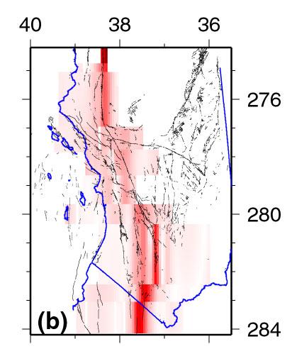
27 Model constraints Vertical Displacement (mm) Distance From fault Axis (Km) Model:Dip-slip + Isostasy Model Data Vertical component Vertical Displacement (mm) Distance From fault Axis (Km) Model Data Model: Dip-slip + Isostasy + Long wavelength load Saleeby et. Al., 2003 Kim Outerbridge et al.
28 Summary Plate Motion Central Baja behave as a rigid block. It moves w/r to the Pacific plate at a rate of 3-8 mm/yr. The relative motion between Baja and Pacific is absorbed by a Baja California Shear Zone Crustal deformation Co- and Post-seismic: leveling, triangulation, trilateration measurements indicate: right-lateral slip of m for the 1940 EQ; 1-4 m for the 1979 EQ cm of post-seismic deformation following both events. Inter-seismic: GPS measurements show strain accumulation across main faults segments. Derived slip-rates are 3-45 mm/yr. Creep: GPS and InSAR measurements indicates 9-18 mm/yr creep along the southern San Andreas and the Imperial faults. InSAR also shows 10 cm of triggered slip following the 1992 Landers EQ. Model constraints Geodetic measurements can constrain estimates of crustal strength and its lateral variations. GPS observed vertical movements in northern Baja suggests a long wavelength (deep) uplifting process, possibly delamination of mantle lithos.
to: Interseismic strain accumulation and the earthquake potential on the southern San
 Supplementary material to: Interseismic strain accumulation and the earthquake potential on the southern San Andreas fault system by Yuri Fialko Methods The San Bernardino-Coachella Valley segment of the
Basics of the modelling of the ground deformations produced by an earthquake. EO Summer School 2014 Frascati August 13 Pierre Briole
 Basics of the modelling of the ground deformations produced by an earthquake EO Summer School 2014 Frascati August 13 Pierre Briole Content Earthquakes and faults Examples of SAR interferograms of earthquakes
Estimating fault slip rates, locking distribution, elastic/viscous properites of lithosphere/asthenosphere. Kaj M. Johnson Indiana University
 3D Viscoelastic Earthquake Cycle Models Estimating fault slip rates, locking distribution, elastic/viscous properites of lithosphere/asthenosphere Kaj M. Johnson Indiana University In collaboration with:
Ground displacement in a fault zone in the presence of asperities
 BOLLETTINO DI GEOFISICA TEORICA ED APPLICATA VOL. 40, N. 2, pp. 95-110; JUNE 2000 Ground displacement in a fault zone in the presence of asperities S. SANTINI (1),A.PIOMBO (2) and M. DRAGONI (2) (1) Istituto
Kinematics of the Southern California Fault System Constrained by GPS Measurements
 Title Page Kinematics of the Southern California Fault System Constrained by GPS Measurements Brendan Meade and Bradford Hager Three basic questions Large historical earthquakes One basic question How
Jack Loveless Department of Geosciences Smith College
 Geodetic constraints on fault interactions and stressing rates in southern California Jack Loveless Department of Geosciences Smith College jloveless@smith.edu Brendan Meade Department of Earth & Planetary
Today: Basic regional framework. Western U.S. setting Eastern California Shear Zone (ECSZ) 1992 Landers EQ 1999 Hector Mine EQ Fault structure
 1992 Landers EQ 1999 Hector Mine EQ Fault structure") Today: Basic regional framework Western U.S. setting Eastern California Shear Zone (ECSZ) 1992 Landers EQ 1999 Hector Mine EQ Fault structure 1 2 Mojave and Southern Basin and Range - distribution of strike-slip
Today: Basic regional framework Western U.S. setting Eastern California Shear Zone (ECSZ) 1992 Landers EQ 1999 Hector Mine EQ Fault structure 1 2 Mojave and Southern Basin and Range - distribution of strike-slip
Comparison of Strain Rate Maps
 Comparison of Strain Rate Maps David T. Sandwell UNAVCO March 8, 2010 why strain rate matters comparison of 10 strain rate models new data required interseismic model velocity v(x) = V π tan 1 x D strain
Lab 9: Satellite Geodesy (35 points)
") Lab 9: Satellite Geodesy (35 points) Here you will work with GPS Time Series data to explore plate motion and deformation in California. This lab modifies an exercise found here: http://www.unavco.org:8080/cws/pbonucleus/draftresources/sanandreas/
Lab 9: Satellite Geodesy (35 points) Here you will work with GPS Time Series data to explore plate motion and deformation in California. This lab modifies an exercise found here: http://www.unavco.org:8080/cws/pbonucleus/draftresources/sanandreas/
} based on composition
 Learning goals: Predict types of earthquakes that will happen at different plate boundaries based on relative plate motion vector vs. strike (vector subtraction) Understand interseismic and coseismic deformation,
Journal of Geophysical Research Letters Supporting Information for
 Journal of Geophysical Research Letters Supporting Information for InSAR observations of strain accumulation and fault creep along the Chaman Fault system, Pakistan and Afghanistan H. Fattahi 1, F. Amelung
Separating Tectonic, Magmatic, Hydrological, and Landslide Signals in GPS Measurements near Lake Tahoe, Nevada-California
 Separating Tectonic, Magmatic, Hydrological, and Landslide Signals in GPS Measurements near Lake Tahoe, Nevada-California Geoffrey Blewitt, Corné Kreemer, William C. Hammond, & Hans-Peter Plag NV Geodetic
Creep along the Imperial Fault, southern California, from GPS measurements
 JOURNAL OF GEOPHYSICAL RESEARCH, VOL. 17, NO. B1, 2249, doi:1.129/21jb763, 22 Creep along the Imperial Fault, southern California, from GPS measurements Suzanne N. Lyons, Yehuda Bock, and David T. Sandwell
Geodetic observations of transient deformation in Southern California
 Geodetic observations of transient deformation in Southern California How do we determine which ones are real? EarthScope Institute on the Spectrum of Fault Slip Portland, Oregon. October 11-14, 2010 Detecting
Plate Boundary Observatory Working Group Plan for the San Andreas Fault System
 Introduction Plate Boundary Observatory Working Group Plan for the San Andreas Fault System This document puts forward a draft implementation plan for the San Andreas Fault component of the Plate Boundary
Plate Boundary Observatory Working Group for the Central and Northern San Andreas Fault System PBO-WG-CNSA
 Plate Boundary Observatory Working Group for the Central and Northern San Andreas Fault System PBO-WG-CNSA Introduction Our proposal focuses on the San Andreas fault system in central and northern California.
The Earthquake Cycle Chapter :: n/a
 The Earthquake Cycle Chapter :: n/a A German seismogram of the 1906 SF EQ Image courtesy of San Francisco Public Library Stages of the Earthquake Cycle The Earthquake cycle is split into several distinct
Elizabeth H. Hearn modified from W. Behr
 Reconciling postseismic and interseismic surface deformation around strike-slip faults: Earthquake-cycle models with finite ruptures and viscous shear zones Elizabeth H. Hearn hearn.liz@gmail.com modified
Power-law distribution of fault slip-rates in southern California
 Click Here for Full Article GEOPHYSICAL RESEARCH LETTERS, VOL. 34, L23307, doi:10.1029/2007gl031454, 2007 Power-law distribution of fault slip-rates in southern California Brendan J. Meade 1 Received 31
Syllabus and Course Description Geophysical Geodesy Fall 2013 GPH 411/611
 Syllabus and Course Description Geophysical Geodesy Fall 2013 GPH 411/611 Course Location: LME 422 Course Time: Tuesday & Thursday 12:00-1:15 Units: 3 Instructor Name: Bill Hammond Office Location: SEM
The SCEC Community Geodetic Model V1: Horizontal Velocity Grid
 The SCEC Community Geodetic Model V1: Horizontal Velocity Grid David T. Sandwell Yuehua Zeng Zheng-Kang Shen Brendan Crowell Jessica Murray Rob McCaffrey Xiaohua Xu Draft V2: October 17, 2016 Abstract
Measurements in the Creeping Section of the Central San Andreas Fault
 Measurements in the Creeping Section of the Central San Andreas Fault Introduction Duncan Agnew, Andy Michael We propose the PBO instrument, with GPS and borehole strainmeters, the creeping section of
Lecture 20: Slow Slip Events and Stress Transfer. GEOS 655 Tectonic Geodesy Jeff Freymueller
 Lecture 20: Slow Slip Events and Stress Transfer GEOS 655 Tectonic Geodesy Jeff Freymueller Slow Slip Events From Kristine Larson What is a Slow Slip Event? Slip on a fault, like in an earthquake, BUT
Can geodetic strain rate be useful in seismic hazard studies?
 Can geodetic strain rate be useful in seismic hazard studies? F. Riguzzi 1, R. Devoti 1, G. Pietrantonio 1, M. Crespi 2, C. Doglioni 2, A.R. Pisani 1 Istituto Nazionale di Geofisica e Vulcanologia 2 Università
Geodetic slip rates in the southern San Andreas Fault system: Effects of elastic heterogeneity and fault geometry
 JOURNAL OF GEOPHYSICAL RESEARCH: SOLID EARTH, VOL. 118, 689 697, doi:10.1029/2012jb009358, 2013 Geodetic slip rates in the southern San Andreas Fault system: Effects of elastic heterogeneity and fault
The problem (1/2) GPS velocity fields in plate boundary zones are very smooth. What does this smoothness hide?
 GPS velocity fields in plate boundary zones are very smooth. What does this smoothness hide?") Block models The problem (1/2) GPS velocity fields in plate boundary zones are very smooth Figure from Tom Herring, MIT What does this smoothness hide? Continuous deformation? Rigid block motions, with
Block models The problem (1/2) GPS velocity fields in plate boundary zones are very smooth Figure from Tom Herring, MIT What does this smoothness hide? Continuous deformation? Rigid block motions, with
GPS Strain & Earthquakes Unit 5: 2014 South Napa earthquake GPS strain analysis student exercise
 GPS Strain & Earthquakes Unit 5: 2014 South Napa earthquake GPS strain analysis student exercise Strain Analysis Introduction Name: The earthquake cycle can be viewed as a process of slow strain accumulation
Slip rates and off-fault deformation in Southern California inferred from GPS data and models
 JOURNAL OF GEOPHYSICAL RESEARCH: SOLID EARTH, VOL. 8, 6 66, doi:./jgrb.6, Slip rates and off-fault deformation in Southern California inferred from GPS data and models K. M. Johnson Received 9 December
Friction can increase with hold time. This happens through growth and increasing shear strength of contacts ( asperities ).
.") Friction can increase with hold time. This happens through growth and increasing shear strength of contacts ( asperities ). If sliding speeds up, the average lifespan of asperities decreases This means
Friction can increase with hold time. This happens through growth and increasing shear strength of contacts ( asperities ). If sliding speeds up, the average lifespan of asperities decreases This means
Geodesy (InSAR, GPS, Gravity) and Big Earthquakes
 and Big Earthquakes") Geodesy (InSAR, GPS, Gravity) and Big Earthquakes Mathew Pritchard Teh-Ru A. Song Yuri Fialko Luis Rivera Mark Simons UJNR Earthquake Research Panel, Morioka, Japan - Nov 6, 2002 Goals Accurate and high
Geodesy (InSAR, GPS, Gravity) and Big Earthquakes Mathew Pritchard Teh-Ru A. Song Yuri Fialko Luis Rivera Mark Simons UJNR Earthquake Research Panel, Morioka, Japan - Nov 6, 2002 Goals Accurate and high
INGV. Giuseppe Pezzo. Istituto Nazionale di Geofisica e Vulcanologia, CNT, Roma. Sessione 1.1: Terremoti e le loro faglie
 Giuseppe Pezzo Istituto Nazionale di Geofisica e Vulcanologia, CNT, Roma giuseppe.pezzo@ingv.it The study of surface deformation is one of the most important topics to improve the knowledge of the deep
Azimuth with RH rule. Quadrant. S 180 Quadrant Azimuth. Azimuth with RH rule N 45 W. Quadrant Azimuth
 30 45 30 45 Strike and dip notation (a) N30 E, 45 SE ("Quadrant"): the bearing of the strike direction is 30 degrees east of north and the dip is 45 degrees in a southeast (SE) direction. For a given strike,
Development of a Predictive Simulation System for Crustal Activities in and around Japan - II
 Development of a Predictive Simulation System for Crustal Activities in and around Japan - II Project Representative Mitsuhiro Matsu'ura Graduate School of Science, The University of Tokyo Authors Mitsuhiro
JOURNAL OF GEOPHYSICAL RESEARCH, VOL. 114, B02403, doi: /2008jb005996, 2009
 Click Here for Full Article JOURNAL OF GEOPHYSICAL RESEARCH, VOL. 114,, doi:10.1029/2008jb005996, 2009 Southern San Andreas-San Jacinto fault system slip rates estimated from earthquake cycle models constrained
Seismic and aseismic processes in elastodynamic simulations of spontaneous fault slip
 Seismic and aseismic processes in elastodynamic simulations of spontaneous fault slip Most earthquake simulations study either one large seismic event with full inertial effects or long-term slip history
MAR110 Lecture #5 Plate Tectonics-Earthquakes
 1 MAR110 Lecture #5 Plate Tectonics-Earthquakes Figure 5.0 Plate Formation & Subduction Destruction The formation of the ocean crust from magma that is upwelled into a pair of spreading centers. Pairs
High-Harmonic Geoid Signatures due to Glacial Isostatic Adjustment, Subduction and Seismic Deformation
 High-Harmonic Geoid Signatures due to Glacial Isostatic Adjustment, Subduction and Seismic Deformation L.L.A. Vermeersen (1), H. Schotman (1), M.-W. Jansen (1), R. Riva (1) and R. Sabadini (2) (1) DEOS,
Earthquakes and Faulting
 Earthquakes and Faulting Crustal Strength Profile Quakes happen in the strong, brittle layers Great San Francisco Earthquake April 18, 1906, 5:12 AM Quake lasted about 60 seconds San Francisco was devastated
Overview of the Seismic Source Characterization for the Palo Verde Nuclear Generating Station
 Overview of the Seismic Source Characterization for the Palo Verde Nuclear Generating Station Scott Lindvall SSC TI Team Lead Palo Verde SSC SSHAC Level 3 Project Tuesday, March 19, 2013 1 Questions from
Deformation cycles of great subduction earthquakes in a viscoelastic Earth
 Deformation cycles of great subduction earthquakes in a viscoelastic Earth Kelin Wang Pacific Geoscience Centre, Geological Survey of Canada School of Earth and Ocean Science, University of Victoria????
Strain rate patterns from dense GPS networks
 Author(s) 2009. This work is distributed under the Creative Commons Attribution 3.0 License. Natural Hazards and Earth System Sciences Strain rate patterns from dense GPS networks M. Hackl 1, R. Malservisi
Initiation of the San Jacinto Fault and its Interaction with the San Andreas Fault: Insights from Geodynamic Modeling
 Pure appl. geophys. (2007) DOI 10.1007/s00024-007-0262-z Ó Birkhäuser Verlag, Basel, 2007 Pure and Applied Geophysics Initiation of the San Jacinto Fault and its Interaction with the San Andreas Fault:
Coulomb stress accumulation along the San Andreas Fault system
 JOURNAL OF GEOPHYSICAL RESEARCH, VOL. 108, NO. B6, 2296, doi:10.1029/2002jb002136, 2003 Coulomb stress accumulation along the San Andreas Fault system Bridget Smith and David Sandwell Institute for Geophysics
Stress modulation on the San Andreas fault by interseismic fault system interactions Jack Loveless and Brendan Meade, Geology, 2011
 Stress modulation on the San Andreas fault by interseismic fault system interactions Jack Loveless and Brendan Meade, Geology, 2011 A three step process: 1 - Assimilate plate boundary wide GPS data into
Interpolation of 2-D Vector Data Using Constraints from Elasticity
 1 Interpolation of 2-D Vector Data Using Constraints from Elasticity David T. Sandwell Scripps Institution of Oceanography, UC San Diego, La Jolla, CA Paul Wessel SOEST, University of Hawaii at Mānoa,
EARTHQUAKE LOCATIONS INDICATE PLATE BOUNDARIES EARTHQUAKE MECHANISMS SHOW MOTION
 6-1 6: EARTHQUAKE FOCAL MECHANISMS AND PLATE MOTIONS Hebgen Lake, Montana 1959 Ms 7.5 1 Stein & Wysession, 2003 Owens Valley, California 1872 Mw ~7.5 EARTHQUAKE LOCATIONS INDICATE PLATE BOUNDARIES EARTHQUAKE
From Earthquakes to Mountains: the Earth s Crust in Motion
 Dean s Freshman Honor Seminar (SCI 110) Eric Calais Associate Professor of Geophysics Purdue University Department of Earth and Atmospheric Sciences ecalais@purdue.edu http:/www.eas.purdue.edu/~calais
Supplementary Material
 1 Supplementary Material 2 3 4 Interseismic, megathrust earthquakes and seismic swarms along the Chilean subduction zone (38-18 S) 5 6 7 8 9 11 12 13 14 1 GPS data set We combined in a single data set
APLICATION OF INSAR TO THE STUDY OF GROUND DEFORMATION IN THE MEXICALI VALLEY, B. C., MEXICO.
 APLICATION OF INSAR TO THE STUDY OF GROUND DEFORMATION IN THE MEXICALI VALLEY, B. C., MEXICO. O. Sarychikhina (1), R. Mellors (2), E. Glowacka (1). (1) Centro de Investigacion Cientifica y Educaccion Superior
Regional deformation and kinematics from GPS data
 Regional deformation and kinematics from GPS data Jessica Murray, Jerry Svarc, Elizabeth Hearn, and Wayne Thatcher U. S. Geological Survey Acknowledgements: Rob McCaffrey, Portland State University UCERF3
Fault Slip Rates, Effects of Sediments and the Strength of the Lower Crust in the Salton Trough Region, Southern California
 Fault Slip Rates, Effects of Sediments and the Strength of the Lower Crust in the Salton Trough Region, Southern California Noah P. Fay and Eugene D. Humphreys University of Oregon Noah Fay Department
Using deformation rates in Northern Cascadia to constrain time-dependent stress- and slip-rate on the megathrust
 Using deformation rates in Northern Cascadia to constrain time-dependent stress- and slip-rate on the megathrust Lucile Bruhat Paul Segall Stanford University 1 50 Interseismic period for the Cascadia
High-resolution temporal imaging of. Howard Zebker
 High-resolution temporal imaging of crustal deformation using InSAR Howard Zebker Stanford University InSAR Prehistory SEASAT Topographic Fringes SEASAT Deformation ERS Earthquake Image Accurate imaging
Depth (Km) + u ( ξ,t) u = v pl. η= Pa s. Distance from Nankai Trough (Km) u(ξ,τ) dξdτ. w(x,t) = G L (x,t τ;ξ,0) t + u(ξ,t) u(ξ,t) = v pl
 + u ( ξ,t) u = v pl. η= Pa s. Distance from Nankai Trough (Km) u(ξ,τ) dξdτ. w(x,t) = G L (x,t τ;ξ,0) t + u(ξ,t) u(ξ,t) = v pl") Slip history during one earthquake cycle at the Nankai subduction zone, inferred from the inversion analysis of levelling data with a viscoelastic slip response function Mitsuhiro Matsu'ura, Akira Nishitani
Slip history during one earthquake cycle at the Nankai subduction zone, inferred from the inversion analysis of levelling data with a viscoelastic slip response function Mitsuhiro Matsu'ura, Akira Nishitani
Numerical modeling of strike-slip creeping faults and implications for the Hayward fault, California
 Tectonophysics 361 (2003) 121 137 www.elsevier.com/locate/tecto Numerical modeling of strike-slip creeping faults and implications for the Hayward fault, California R. Malservisi*, C. Gans, K.P. Furlong
Study megathrust creep to understand megathrust earthquakes
 1 Study megathrust creep to understand megathrust earthquakes Kelin Wang Pacific Geoscience Centre, Geological Survey of Canada, kelin.wang@canada.ca Introduction Once upon a time, there was a belief that
Y. Kaneko, 1 Y. Fialko, 1 D. T. Sandwell, 1 X. Tong, 1 and M. Furuya Introduction
 JOURNAL OF GEOPHYSICAL RESEARCH: SOLID EARTH, VOL. 118, 316 331, doi:1.19/1jb9661, 13 Interseismic deformation and creep along the central section of the North Anatolian Fault (Turkey): InSAR observations
Karl Mueller QUATERNARY RIFT FLANK UPLIFT OF THE PENINSULAR RANGES IN BAJA AND SOUTHERN CALIFORNIA BY REMOVAL OF MANTLE LITHOSPHERE
 QUATERNARY RIFT FLANK UPLIFT OF THE PENINSULAR RANGES IN BAJA AND SOUTHERN CALIFORNIA BY REMOVAL OF MANTLE LITHOSPHERE August 2013 Quaternary Rift Flank Uplift of the Peninsular Ranges in Baja and Southern
Slip on faults in the Imperial Valley triggered by the 4 April 2010 Mw 7.2 El Mayor Cucapah earthquake revealed by InSAR
 GEOPHYSICAL RESEARCH LETTERS, VOL. 38,, doi:10.1029/2010gl045235, 2011 Slip on faults in the Imperial Valley triggered by the 4 April 2010 Mw 7.2 El Mayor Cucapah earthquake revealed by InSAR Meng Wei,
Evolution of stress in Southern California for the past 200 years from coseismic, postseismic and interseismic stress changes
 Geophys. J. Int. (2007) 169, 1164 1179 doi: 10.1111/j.1365-246X.2007.03391.x Evolution of stress in Southern California for the past 200 years from coseismic, postseismic and interseismic stress changes
LAB 5: THE EARTHQUAKE CYCLE
 NAME: LAB TIME: LAB 5: THE EARTHQUAKE CYCLE This lab will introduce you to the basic quantitative concepts of the earthquake cycle for a vertical strike-slip fault. Most of your time will be spent calculating
Analytic and Numeric Tests of Fourier Deformation Model (Copyright 2003, Bridget R. Smith and David T. Sandwell)
") Analytic and Numeric Tests of Fourier Deformation Model (Copyright 2003, Bridget R. Smith and David T. Sandwell) Although the solutions of our Fourier deformation model have been checked using computer
Analytic and Numeric Tests of Fourier Deformation Model (Copyright 2003, Bridget R. Smith and David T. Sandwell) Although the solutions of our Fourier deformation model have been checked using computer
San Andreas Movie Can It Happen?
 San Andreas Movie Can It Happen? Learning Objectives (LO) Lecture 14: Faults and Quakes Read: Chapter 10 and 11 Homework #12 due Thursday 12pm What we ll learn today:! 1. Compare strike-slip to dip-slip
JOURNAL OF GEOPHYSICAL RESEARCH, VOL. 110, B09401, doi: /2004jb003548, 2005
 JOURNAL OF GEOPHYSICAL RESEARCH, VOL. 110,, doi:10.1029/2004jb003548, 2005 Fault slip rates, effects of elastic heterogeneity on geodetic data, and the strength of the lower crust in the Salton Trough
GPS Monitoring of the San Andreas Fault and Modeling of Slip Rate on the Mojave Section of the San Andreas Fault
 GPS Monitoring 1 GPS Monitoring of the San Andreas Fault and Modeling of Slip Rate on the Mojave Section of the San Andreas Fault By Nayeli Jimenez and Mischel Bartie PRISM Research Program Coordinator:
Crustal Deformation Earth - Chapter Pearson Education, Inc.
 Crustal Deformation Earth - Chapter 10 Structural Geology Structural geologists study the architecture and processes responsible for deformation of Earth s crust. A working knowledge of rock structures
Comparison of 17 Strain-Rate Models from GPS Geodesy
 Comparison of 17 Strain-Rate Models from GPS Geodesy overview of 17 strain rate models fits to dense GPS and 12 models too smooth cross correlation among models and seismicity rate strain-rate tensor maps
Effect of an outer-rise earthquake on seismic cycle of large interplate earthquakes estimated from an instability model based on friction mechanics
 Effect of an outer-rise earthquake on seismic cycle of large interplate earthquakes estimated from an instability model based on friction mechanics Naoyuki Kato (1) and Tomowo Hirasawa (2) (1) Geological
Stress equilibrium in southern California from Maxwell stress function models fit to both earthquake data and a quasi-static dynamic simulation
 Stress equilibrium in southern California from Maxwell stress function models fit to both earthquake data and a quasi-static dynamic simulation Peter Bird Dept. of Earth, Planetary, and Space Sciences
Strain accumulation at Yucca Mountain, Nevada,
 JOURNAL OF GEOPHYSICAL RESEARCH, VOL. 104, NO. B8, PAGES 17,627-17,631, AUGUST 10, 1999 Strain accumulation at Yucca Mountain, Nevada, 1983-1998 J. C. Savage, J.L. Svarc, and W. H. Prescott U.S. Geological
Earthquake distribution is not random: very narrow deforming zones (= plate boundaries) versus large areas with no earthquakes (= rigid plate
 versus large areas with no earthquakes (= rigid plate") Earthquake distribution is not random: very narrow deforming zones (= plate boundaries) versus large areas with no earthquakes (= rigid plate interiors) Tectonic plates and their boundaries today -- continents
Earthquake distribution is not random: very narrow deforming zones (= plate boundaries) versus large areas with no earthquakes (= rigid plate interiors) Tectonic plates and their boundaries today -- continents
MAR110 LECTURE #6 West Coast Earthquakes & Hot Spots
 17 September 2007 Lecture 6 West Coast Earthquakes & Hot Spots 1 MAR110 LECTURE #6 West Coast Earthquakes & Hot Spots Figure 6.1 Plate Formation & Subduction Destruction The formation of the ocean crust
Mid-Continent Earthquakes As A Complex System
 SRL complex earthquakes 5/22/09 1 Mid-Continent Earthquakes As A Complex System Niels Bohr once observed How wonderful that we have met with a paradox. Now we have some hope of making progress. This situation
Aseismic slip and fault-normal strain along the central creeping section of the San Andreas fault
 Click Here for Full Article GEOPHYSICAL RESEARCH LETTERS, VOL. 35, L14305, doi:10.1029/2008gl034437, 2008 Aseismic slip and fault-normal strain along the central creeping section of the San Andreas fault
Synthetic Seismicity Models of Multiple Interacting Faults
 Synthetic Seismicity Models of Multiple Interacting Faults Russell Robinson and Rafael Benites Institute of Geological & Nuclear Sciences, Box 30368, Lower Hutt, New Zealand (email: r.robinson@gns.cri.nz).
Activity Pacific Northwest Tectonic Block Model
 Activity Pacific Northwest Tectonic Block Model The Cascadia tectonic margin is caught between several tectonic forces, during the relentless motions of the giant Pacific Plate, the smaller subducting
Earthquakes. Earthquake Magnitudes 10/1/2013. Environmental Geology Chapter 8 Earthquakes and Related Phenomena
 Environmental Geology Chapter 8 Earthquakes and Related Phenomena Fall 2013 Northridge 1994 Kobe 1995 Mexico City 1985 China 2008 Earthquakes Earthquake Magnitudes Earthquake Magnitudes Richter Magnitude
A block-fault model for deformation of the Japanese Islands derived from continuous GPS observation
 LETTER Earth Planets Space, 52, 1095 1100, 2000 A block-fault model for deformation of the Japanese Islands derived from continuous GPS observation Manabu Hashimoto 1, Shin ichi Miyazaki 2, and David D.
Sendai Earthquake NE Japan March 11, Some explanatory slides Bob Stern, Dave Scholl, others updated March
 Sendai Earthquake NE Japan March 11, 2011 Some explanatory slides Bob Stern, Dave Scholl, others updated March 14 2011 Earth has 11 large plates and many more smaller ones. Plates are 100-200 km thick
The Tectonic Setting of New Zealand
 The Tectonic Setting of New Zealand we are here Subduction-driven tectonics The New Zealand continent Papua New Guinea Australia 3,000,000 sq km micro-continent back-arc basin trench volcanism faults accretionary
Crustal Deformation. Earth Systems 3209
 Crustal Deformation Earth Systems 3209 Crustal Deformation pg. 415 Refers to all changes in the original form and/or size of a rock body. May also produce changes in the location and orientation of rocks.
AN INTRODUCTION TO EARTHQUAKE GEODESY : Another Effort for Earthquake Hazard Monitoring
 AN INTRODUCTION TO EARTHQUAKE GEODESY : Another Effort for Earthquake Hazard Monitoring Andreas H., Irwan M., H.Z.Abidin, D. Darmawan, D.A. Sarsito, M. Gamal Geodesy Research Group Department of Geodetic
What is the LAB Dynamically: Lithosphere and Asthenosphere Rheology from Post-loading Deformation
 What is the LAB Dynamically: Lithosphere and Asthenosphere Rheology from Post-loading Deformation Roland Bürgmann, UC Berkeley With contributions by Pascal Audet, Daula Chandrasekhar, Georg Dresen, Andy
Long-term Crustal Deformation in and around Japan, Simulated by a 3-D Plate Subduction Model
 Long-term Crustal Deformation in and around Japan, Simulated by a 3-D Plate Subduction Model Chihiro Hashimoto (1) and Mitsuhiro Matsu ura (2) (1) Institute of Frontier Research for Earth Evolution, Japan
BRIDGET R. SMITH-KONTER *
 BRIDGET R. SMITH-KONTER * NASA, Jet Propulsion Laboratory California Institute of Technology M/S 183-501, Pasadena, California 91109 Tel: (818) 354-2076 Email: Bridget.R.Konter@jpl.nasa.gov Website: http://topex.ucsd.edu/bsmith
Okada, 1985, Text
 Okada, 19, 1992 Buried dislocation Elastic half-space Relates slip on patch to 3d displacements at surface Differs from seismology where source is infinitesimal Text Strike Slip From Segall, 2 Dip Slip
Constraints on fault slip rates of the southern California plate boundary from GPS velocity and stress inversions
 Geophys. J. Int. (2005) 160, 634 650 doi: 10.1111/j.1365-246X.2004.02528.x Constraints on fault slip rates of the southern California plate boundary from GPS velocity and stress inversions Thorsten W.
A Unified Analysis of Crustal Motion in California, : The SCEC Crustal Motion Map
 A Unified Analysis of Crustal Motion in California, 1970-2004: The SCEC Crustal Motion Map Z.-K. Shen, R. W. King, D. C. Agnew, M. Wang, T. A. Herring, D. Dong, and P. Fang Abstract To determine crustal
Surface changes caused by erosion and sedimentation were treated by solving: (2)
") GSA DATA REPOSITORY 214279 GUY SIMPSON Model with dynamic faulting and surface processes The model used for the simulations reported in Figures 1-3 of the main text is based on two dimensional (plane strain)
GSA DATA REPOSITORY 214279 GUY SIMPSON Model with dynamic faulting and surface processes The model used for the simulations reported in Figures 1-3 of the main text is based on two dimensional (plane strain)
Earthquake and Volcano Deformation
 Earthquake and Volcano Deformation Paul Segall Stanford University Draft Copy September, 2005 Last Updated Sept, 2008 COPYRIGHT NOTICE: To be published by Princeton University Press and copyrighted, c
Differentiating earthquake tsunamis from other sources; how do we tell the difference?
 Differentiating earthquake tsunamis from other sources; how do we tell the difference? David Tappin (1), Stephan Grilli (2), Jeffrey Harris (2), Timothy Masterlark (3), James Kirby (4), Fengyan Shi Shi
Geodetic strain across the San Andreas fault reflects elastic plate thickness variations (rather than fault slip rate)
") Available online at www.sciencedirect.com Earth and Planetary Science Letters 269 (2008) 352 365 www.elsevier.com/locate/epsl Geodetic strain across the San Andreas fault reflects elastic plate thickness
Available online at www.sciencedirect.com Earth and Planetary Science Letters 269 (2008) 352 365 www.elsevier.com/locate/epsl Geodetic strain across the San Andreas fault reflects elastic plate thickness
The Hector Mine, California, Earthquake of 16 October 1999: Introduction to the Special Issue
 Bulletin of the Seismological Society of America, Vol. 92, No. 4, pp. 1147 1153, May 2002 The Hector Mine, California, Earthquake of 16 October 1999: Introduction to the Special Issue by Michael J. Rymer,
Geologic Structures. Changes in the shape and/or orientation of rocks in response to applied stress
 Geologic Structures Changes in the shape and/or orientation of rocks in response to applied stress Figure 15.19 Can be as big as a breadbox Or much bigger than a breadbox Three basic types Fractures >>>
Electro-Optical Distance Measurements in the Tokai Region, Central Japan ( )
") Electro-Optical Distance Measurements in the Tokai Region, Central Japan (1977-1981) Fumiaki KIMATA Inuyama Crustal Movement Observatory, School of Science,. Nagoya University Tsuneo and YAMAUCHI Regional
Electro-Optical Distance Measurements in the Tokai Region, Central Japan (1977-1981) Fumiaki KIMATA Inuyama Crustal Movement Observatory, School of Science,. Nagoya University Tsuneo and YAMAUCHI Regional
A viscoelastic model of interseismic strain concentration in Niigata-Kobe Tectonic Zone of central Japan
 Earth Planets Space, 55, 667 675, 2003 A viscoelastic model of interseismic strain concentration in Niigata-Kobe Tectonic Zone of central Japan Mamoru Hyodo 1 and Kazuro Hirahara 2 1 Graduate School of
Case Study 1: 2014 Chiang Rai Sequence
 Case Study 1: 2014 Chiang Rai Sequence Overview Mw 6.1 earthquake on 5 May 2014 at 11:08:43 UTC Largest recorded earthquake in Thailand Fault Orientation How does the orientation of the fault affect the
SUPPLEMENTARY INFORMATION
 SUPPLEMENTARY INFORMATION doi: 10.1038/ngeo739 Supplementary Information to variability and distributed deformation in the Marmara Sea fault system Tobias Hergert 1 and Oliver Heidbach 1,* 1 Geophysical
Earthquakes Chapter 19
 Earthquakes Chapter 19 Does not contain complete lecture notes. What is an earthquake An earthquake is the vibration of Earth produced by the rapid release of energy Energy released radiates in all directions
A model of the earthquake cycle along the San Andreas Fault System for the past 1000 years
 JOURNAL OF GEOPHYSICAL RESEARCH, VOL. 111,, doi:10.1029/2005jb003703, 2006 A model of the earthquake cycle along the San Andreas Fault System for the past 1000 years Bridget R. Smith and David T. Sandwell