Separating Tectonic, Magmatic, Hydrological, and Landslide Signals in GPS Measurements near Lake Tahoe, Nevada-California
|
|
|
- Jayson Stevens
- 5 years ago
- Views:
Transcription

1 Separating Tectonic, Magmatic, Hydrological, and Landslide Signals in GPS Measurements near Lake Tahoe, Nevada-California Geoffrey Blewitt, Corné Kreemer, William C. Hammond, & Hans-Peter Plag NV Geodetic Laboratory, NV Bureau of Mines & Geology, University of Nevada, Reno with thanks to Ken Smith and David Von Seggern

2 Separating Tectonic, Magmatic Hydrological and Landslide Signals Two case studies of GPS transients Slide Mountain 2003 Smith et al., 2004, doi: /science Mogul-Sommerset 2008 Both transients coeval with earthquake swarms Swarms of magmatic or tectonic origin? Transients from crustal deformation or landsliding? Transients complicated by hydrological effects

3 Summary of SLID Transient August 2003 January 2004 Earthquake swarm under Lake Tahoe km deep below seismogenic zone Rheological implication rapid stress change Seismic moment Mw 3.8 GPS transient at SLID 3-D displacement ~12 mm Geodetic moment Mw 6.1 Timing is the same as seismic 99% aseismic Evidence magmatic
4 Depth of Seismicity vs Time (Smith et al., 2004) 1. Quakes are below typical seismogenic depth, which requires a very rapid stress transient 2. Seismic time series starts with upward trend at 2.4 mm / second 8.5 m / hour 1.4 km / week 3. Supports hypothesis of lower crustal magmatic intrusion, migrating upward.
5 Seismological Analysis (Ken Smith & D. Von Seggern) Deep event has clearly ended on Jan Shallow µ -seismicity follows deep Event Brittle response
6 SLID GPS GPS Method seasonal and secular removed model during seismic quiescence Fit to transient Blue curve is not GPS!! Cumulative moment from deep earthquakes Curve scaled to fit GPS data N = 4 mm E = 6 mm U = 9 mm Okada model for tensile crack moment Mw % aseismic Earthquakes only a symptom of the process, not the cause East velocity changes! Regional magmatics at work?
7 SLID Time-Series Filter (pre ) Global Frame Western US Frame Seasonal Removed
8 TONO (control) Time-Series Filter (pre ) Global Frame Western US Frame Seasonal Removed
 (Mw 5.")
9 Mogul Earthquake Swarm, Feb-Aug 2008 (Ken Smith) (Mw 5.0) My house

10 GPS Site RENO Installed January 2004 Installed January 2004 MAGNET network Now > 300 stations Fortuitous Location Within Mogul swarm 200 meters from Mw5.0 mainshock, April 2008! Smallest earthquake measured by GPS
11 RENO GPS Co-seismic offset Mw 5.0, 25 April 2008 No pre-seismic signal Large post-seismic slip


12 Tectonic or Triggered Landslide? The Mogul Landslide Active ~100,000 yr Last slide ~1900 induced by irrigation ditch RENO GPS site lies above the eastern headwall STDI Installed 20 May 2008 Above southern headwall 296 m from RENO STDI RENO
13 Mogul Landslide Experiment RENO-STDI (296 m) Red = RENO Blue = STDI
14 Mogul Landslide Experiment RENO-STDI (296 m) Rel. Motion << 1 mm Clearly no landsliding

15 GPS Regional Strain-Rate Tensor Pre-Seismic MOGL RNO1 VRDE RENO Velocities relative to Sierra Nevada Transtensional Strain = Shear + E-W Extension No-length change aligns with strike-slip seismicity Indicates tectonic response not magmatic
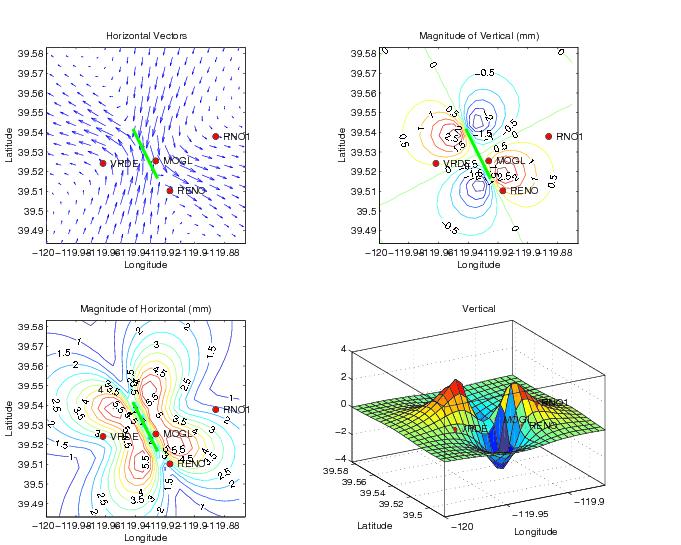
16 GPS Signals over few km 2 days pre-seismic MOGL southward Consistent with regional inter-seismic strain tensor Strain-Rate Tensor 2 days pre-seismic VRDE westward RNO1 VRDE MOGL RENO RENO northward RNO1 eastward (hydological?)
17 GPS Signals over few km 2 days pre-seismic MOGL southward Strain-Rate Tensor 2 days pre-seismic VRDE westward RNO1 VRDE MOGL RENO RENO northward Consistent with regional inter-seismic strain tensor RNO1 eastward
18 Post-Seismic After-Slip Model Estimated logarithmic time constant = 0.9 days
19 Co- and Post-Seismic Motion are closely aligned
20 Dislocation Model
21 Co- and Post-Seismic Slip Model Green: co-seismic (Apr 26) Red: post-seismic (to May 19)
22 Mogul Swarm Summary Co-seismic displacements of Mw5.0 main shock Measured at 4 GPS stations Landsliding not responsible for detected GPS signal Displacement pattern consistent with regional strain tensor swarm seismicity pattern Post-seismic consistent with after-slip Evidence tectonic source, not magmatic Hydrological signals may confound RNO1 Bad GPS site not attached to bedrock Large seasonal signal estimated and removed Residual signal consistent with tectonics
23 Velocities Swarm Dilatation Uplift Geothermal Swarm Strain rate Geothermal Swarm Reno-Tahoe Regional Deformation Mix of shear and extension Mogul swarm consistent with high shear localized on Mount Rose fault Incipient fault propagation? Tahoe swarm consistent with magmatics Uplift associated dilitational stress Geothermal area is magmatic?
 San Andreas Reno-Tahoe Uplift Geothermally active Magmatic")
24 GPS Vertical Velocity Map Great Valley Huge subsidence Bad stations included Hydrological effects Areas of Uplift Sierra Nevada Mt Lassen, Mammoth CNSB (postseismic) San Andreas Reno-Tahoe Uplift Geothermally active Magmatic evidence


25 Velocities Strain rate Deformation in RenoTahoe Area Temperature Dilatation Uplift Extensionalmagmatic relationship? (crustal doming)
26 Separating Signals: Lessons Learned 1. GPS+micro-seismology is powerful combination Pattern + timing Use all evidence to construct displacement model 2. Exploit data during relative seismic quiescence: GPS Velocities Regional Tectonics Process(t,x)? GPS Seasonal Signals Hydrological Loading Identify hydrological bad GPS sites 3. Consider greater regional context What is typical or unusual? 4. These techniques identify magmatic-tectonic interaction in the Reno-Tahoe area
Evidence for Deep Magma Injection Beneath Lake Tahoe, Nevada-California
 Evidence for Deep Magma Injection Beneath Lake Tahoe, Nevada-California Kenneth D. Smith, 1* David von Seggern, 1 Geoffrey Blewitt, 1,2 Leiph Preston, 1 John G. Anderson, 1 Brian P. Wernicke, 3 James L.
MIGRATING SWARMS OF BRITTLE-FAILURE EARTHQUAKES IN THE LOWER CRUST BENEATH MAMMOTH MOUNTAIN, CALIFORNIA
 MIGRATING SWARMS OF BRITTLE-FAILURE EARTHQUAKES IN THE LOWER CRUST BENEATH MAMMOTH MOUNTAIN, CALIFORNIA David Shelly and David Hill GRL, October 2011 Contents Tectonic Setting Long Valley Caldera Mammoth
Okada, 1985, Text
 Okada, 19, 1992 Buried dislocation Elastic half-space Relates slip on patch to 3d displacements at surface Differs from seismology where source is infinitesimal Text Strike Slip From Segall, 2 Dip Slip
Regional Geodesy. Shimon Wdowinski. MARGINS-RCL Workshop Lithospheric Rupture in the Gulf of California Salton Trough Region. University of Miami
 MARGINS-RCL Workshop Lithospheric Rupture in the Gulf of California Salton Trough Region Regional Geodesy Shimon Wdowinski University of Miami Rowena Lohman, Kim Outerbridge, Tom Rockwell, and Gina Schmalze
Low-Latency Earthquake Displacement Fields for Tsunami Early Warning and Rapid Response Support
 Low-Latency Earthquake Displacement Fields for Tsunami Early Warning and Rapid Response Support Hans-Peter Plag, Geoffrey Blewitt Nevada Bureau of Mines and Geology and Seismological Laboratory University
Foreshocks to Major Earthquakes In Nevada. Craig M. depolo Nevada Bureau of Mines and Geology
 Foreshocks to Major Earthquakes In Nevada Craig M. depolo Nevada Bureau of Mines and Geology Review foreshocks, particularly the 2008 Mogul earthquake, foreshock statistics and implications, multiple earthquakes
Syllabus and Course Description Geophysical Geodesy Fall 2013 GPH 411/611
 Syllabus and Course Description Geophysical Geodesy Fall 2013 GPH 411/611 Course Location: LME 422 Course Time: Tuesday & Thursday 12:00-1:15 Units: 3 Instructor Name: Bill Hammond Office Location: SEM
Targeting of Potential Geothermal Resources in the Great Basin from Regional Relationships between Geodetic Strain and Geological Structures
 Targeting of Potential Geothermal Resources in the Great Basin from Regional Relationships between Geodetic Strain and Geological Structures Geoffrey Blewitt and Mark Coolbaugh Great Basin Center for Geothermal
Rapid Determination of Earthquake Magnitude using GPS for Tsunami Warning Systems: An Opportunity for IGS to Make a Difference
 Rapid Determination of Earthquake Magnitude using GPS for Tsunami Warning Systems: An Opportunity for IGS to Make a Difference Geoffrey Blewitt, 1 Corné Kreemer, 1 William C. Hammond, 1 Hans-Peter Plag,
Lecture 20: Slow Slip Events and Stress Transfer. GEOS 655 Tectonic Geodesy Jeff Freymueller
 Lecture 20: Slow Slip Events and Stress Transfer GEOS 655 Tectonic Geodesy Jeff Freymueller Slow Slip Events From Kristine Larson What is a Slow Slip Event? Slip on a fault, like in an earthquake, BUT
Earthquake and Volcano Deformation
 Earthquake and Volcano Deformation Paul Segall Stanford University Draft Copy September, 2005 Last Updated Sept, 2008 COPYRIGHT NOTICE: To be published by Princeton University Press and copyrighted, c
Lecture # 6. Geological Structures
 1 Lecture # 6 Geological Structures ( Folds, Faults and Joints) Instructor: Dr. Attaullah Shah Department of Civil Engineering Swedish College of Engineering and Technology-Wah Cantt. 2 The wavy undulations
INGV. Giuseppe Pezzo. Istituto Nazionale di Geofisica e Vulcanologia, CNT, Roma. Sessione 1.1: Terremoti e le loro faglie
 Giuseppe Pezzo Istituto Nazionale di Geofisica e Vulcanologia, CNT, Roma giuseppe.pezzo@ingv.it The study of surface deformation is one of the most important topics to improve the knowledge of the deep
Lab 9: Satellite Geodesy (35 points)
") Lab 9: Satellite Geodesy (35 points) Here you will work with GPS Time Series data to explore plate motion and deformation in California. This lab modifies an exercise found here: http://www.unavco.org:8080/cws/pbonucleus/draftresources/sanandreas/
Lab 9: Satellite Geodesy (35 points) Here you will work with GPS Time Series data to explore plate motion and deformation in California. This lab modifies an exercise found here: http://www.unavco.org:8080/cws/pbonucleus/draftresources/sanandreas/
The Earthquake Cycle Chapter :: n/a
 The Earthquake Cycle Chapter :: n/a A German seismogram of the 1906 SF EQ Image courtesy of San Francisco Public Library Stages of the Earthquake Cycle The Earthquake cycle is split into several distinct
3D temporal evolution of displacements recorded on Mt. Etna from the 2007 to 2010 through the SISTEM method
 3D temporal evolution of displacements recorded on Mt. Etna from the 2007 to 2010 through the SISTEM method Bonforte A., Guglielmino F.,, Puglisi G. INGV Istituto Nazionale di Gofisica e vulcanologia Osservatorio
Deformation of Rocks. Orientation of Deformed Rocks
 Deformation of Rocks Folds and faults are geologic structures caused by deformation. Structural geology is the study of the deformation of rocks and its effects. Fig. 7.1 Orientation of Deformed Rocks
Ground displacement in a fault zone in the presence of asperities
 BOLLETTINO DI GEOFISICA TEORICA ED APPLICATA VOL. 40, N. 2, pp. 95-110; JUNE 2000 Ground displacement in a fault zone in the presence of asperities S. SANTINI (1),A.PIOMBO (2) and M. DRAGONI (2) (1) Istituto
Earthquakes and Faulting
 Earthquakes and Faulting Crustal Strength Profile Quakes happen in the strong, brittle layers Great San Francisco Earthquake April 18, 1906, 5:12 AM Quake lasted about 60 seconds San Francisco was devastated
Coulomb stress changes due to Queensland earthquakes and the implications for seismic risk assessment
 Coulomb stress changes due to Queensland earthquakes and the implications for seismic risk assessment Abstract D. Weatherley University of Queensland Coulomb stress change analysis has been applied in
Today: Basic regional framework. Western U.S. setting Eastern California Shear Zone (ECSZ) 1992 Landers EQ 1999 Hector Mine EQ Fault structure
 1992 Landers EQ 1999 Hector Mine EQ Fault structure") Today: Basic regional framework Western U.S. setting Eastern California Shear Zone (ECSZ) 1992 Landers EQ 1999 Hector Mine EQ Fault structure 1 2 Mojave and Southern Basin and Range - distribution of strike-slip
Today: Basic regional framework Western U.S. setting Eastern California Shear Zone (ECSZ) 1992 Landers EQ 1999 Hector Mine EQ Fault structure 1 2 Mojave and Southern Basin and Range - distribution of strike-slip
Exploring the Relationship between Geothermal Resources and Geodetically Inferred Faults Slip Rates in the Great Basin
 Exploring the Relationship between Geothermal Resources and Geodetically Inferred Faults Slip Rates in the Great Basin William C. Hammond, Corné Kreemer, Geoff Blewitt Nevada Bureau of Mines and Geology
Testing for fault activity at Yucca Mountain, Nevada, using independent GPS results from the BARGEN network
 Click Here for Full Article GEOPHYSICAL RESEARCH LETTERS, VOL. 33, L14302, doi:10.1029/2006gl026140, 2006 Testing for fault activity at Yucca Mountain, Nevada, using independent GPS results from the BARGEN
ABSTRACT. * ,
 Geothermal systems in the Great Basin, western United States: Modern analogues to the roles of magmatism, structure, and regional tectonics in the formation of gold deposits Mark F. Coolbaugh* Great Basin
Basics of the modelling of the ground deformations produced by an earthquake. EO Summer School 2014 Frascati August 13 Pierre Briole
 Basics of the modelling of the ground deformations produced by an earthquake EO Summer School 2014 Frascati August 13 Pierre Briole Content Earthquakes and faults Examples of SAR interferograms of earthquakes
GPS Strain & Earthquakes Unit 5: 2014 South Napa earthquake GPS strain analysis student exercise
 GPS Strain & Earthquakes Unit 5: 2014 South Napa earthquake GPS strain analysis student exercise Strain Analysis Introduction Name: The earthquake cycle can be viewed as a process of slow strain accumulation
Exploring the Relationship between Geothermal Resources and Geodetically Inferred Faults Slip Rates in the Great Basin
 GRC Transactions, Vol. 31, 2007 Exploring the Relationship between Geothermal Resources and Geodetically Inferred Faults Slip Rates in the Great Basin William C. Hammond, Corné Kreemer, and Geoff Blewitt
Constraints on Intra-Continental Strain Rates and Glacial Isostatic Adjustment from Thousands of GPS Velocities
 Constraints on Intra-Continental Strain Rates and Glacial Isostatic Adjustment from Thousands of GPS Velocities Corné Kreemer William Hammond & Geoffrey Blewitt Nevada Geodetic Laboratory, NV Bureau of
Fault Specific, Dynamic Rupture Scenarios for Strong Ground Motion Prediction
 Fault Specific, Dynamic Rupture Scenarios for Strong Ground Motion Prediction H. Sekiguchi Disaster Prevention Research Institute, Kyoto University, Japan Blank Line 9 pt Y. Kase Active Fault and Earthquake
Kinematics of the Southern California Fault System Constrained by GPS Measurements
 Title Page Kinematics of the Southern California Fault System Constrained by GPS Measurements Brendan Meade and Bradford Hager Three basic questions Large historical earthquakes One basic question How
Contemporary Tectonics and Seismicity of the Teton and Southern Yellowstone Fault Systems- Phase I
 University of Wyoming National Park Service Research Center Annual Report Volume 4 4th Annual Report, 1980 Article 16 1-1-1980 Contemporary Tectonics and Seismicity of the Teton and Southern Yellowstone
Earthquake and Volcano Clustering at Mono Basin (California)
") Excerpt from the Proceedings of the COMSOL Conference 2010 Paris Earthquake and Volcano Clustering at Mono Basin (California) D. La Marra *,1, A. Manconi 2,3 and M. Battaglia 1 1 Dept of Earth Sciences,
Excerpt from the Proceedings of the COMSOL Conference 2010 Paris Earthquake and Volcano Clustering at Mono Basin (California) D. La Marra *,1, A. Manconi 2,3 and M. Battaglia 1 1 Dept of Earth Sciences,
Analysis of Vertical Velocities from BARGEN Continuous GPS Data at Yucca Mountain, Southern Nevada
 Analysis of Vertical Velocities from BARGEN Continuous GPS Data at Yucca Mountain, Southern Nevada Emma Hill and Geoffrey Blewitt Nevada Bureau of Mines and Geology/178 University of Nevada, Reno Reno,
Geodesy (InSAR, GPS, Gravity) and Big Earthquakes
 and Big Earthquakes") Geodesy (InSAR, GPS, Gravity) and Big Earthquakes Mathew Pritchard Teh-Ru A. Song Yuri Fialko Luis Rivera Mark Simons UJNR Earthquake Research Panel, Morioka, Japan - Nov 6, 2002 Goals Accurate and high
Geodesy (InSAR, GPS, Gravity) and Big Earthquakes Mathew Pritchard Teh-Ru A. Song Yuri Fialko Luis Rivera Mark Simons UJNR Earthquake Research Panel, Morioka, Japan - Nov 6, 2002 Goals Accurate and high
NOTICE CONCERNING COPYRIGHT RESTRICTIONS
 NOTICE CONCERNING COPYRIGHT RESTRICTIONS This document may contain copyrighted materials. These materials have been made available for use in research, teaching, and private study, but may not be used
Jack Loveless Department of Geosciences Smith College
 Geodetic constraints on fault interactions and stressing rates in southern California Jack Loveless Department of Geosciences Smith College jloveless@smith.edu Brendan Meade Department of Earth & Planetary
Gutenberg-Richter Relationship: Magnitude vs. frequency of occurrence
 Quakes per year. Major = 7-7.9; Great = 8 or larger. Year Major quakes Great quakes 1969 15 1 1970 20 0 1971 19 1 1972 15 0 1973 13 0 1974 14 0 1975 14 1 1976 15 2 1977 11 2 1978 16 1 1979 13 0 1980 13
The Earthquake of Padang, Sumatra of 30 September 2009 scientific information and update
 The Earthquake of Padang, Sumatra of 30 September 2009 scientific information and update 01-October-2009 Christophe Vigny Directeur de recherches at CNRS Laboratoire de Géologie Geoscience Dept. Of ENS,
Comparison of Strain Rate Maps
 Comparison of Strain Rate Maps David T. Sandwell UNAVCO March 8, 2010 why strain rate matters comparison of 10 strain rate models new data required interseismic model velocity v(x) = V π tan 1 x D strain
Activity Pacific Northwest Tectonic Block Model
 Activity Pacific Northwest Tectonic Block Model The Cascadia tectonic margin is caught between several tectonic forces, during the relentless motions of the giant Pacific Plate, the smaller subducting
Earthquakes and Earthquake Hazards Earth - Chapter 11 Stan Hatfield Southwestern Illinois College
 Earthquakes and Earthquake Hazards Earth - Chapter 11 Stan Hatfield Southwestern Illinois College What Is an Earthquake? An earthquake is the vibration of Earth, produced by the rapid release of energy.
Earthquake Hazards in Douglas County
 Earthquake Hazards in Douglas County Craig M. depolo Nevada Bureau of Mines and Geology Nevada Hazard Mitigation Planning Committee August 9, 2012 Earthquake Truths The consequences of bad earthquakes
Volcano Seismicity and Tremor. Geodetic + Seismic
 Volcano Seismicity and Tremor Seismic Imaging Geodetic + Seismic Model based joint inversion Geodetic Monitoring How is magma stored in the crust? geometry, volume and physical state of crustal melts.
Case Study 1: 2014 Chiang Rai Sequence
 Case Study 1: 2014 Chiang Rai Sequence Overview Mw 6.1 earthquake on 5 May 2014 at 11:08:43 UTC Largest recorded earthquake in Thailand Fault Orientation How does the orientation of the fault affect the
Mountains and Mountain Building: Chapter 11
 Mountains and Mountain Building: Chapter 11 Objectives: 1)Explain how some of Earth s major mountain belts formed 2) Compare and contrast active and passive continental margins 3) Explain how compression,
Chapter 15 Structures
 Chapter 15 Structures Plummer/McGeary/Carlson (c) The McGraw-Hill Companies, Inc. TECTONIC FORCES AT WORK Stress & Strain Stress Strain Compressive stress Shortening strain Tensional stress stretching
Regional Patterns of Geothermal Activity in the Great Basin Region, Western USA: Correlation With Strain Rates
 GRC Transactions, Vol. 36, 2012 Regional Patterns of Geothermal Activity in the Great Basin Region, Western USA: Correlation With Strain Rates James E. Faulds, Nicholas Hinz, Corné Kreemer, and Mark Coolbaugh
Earthquakes Chapter 19
 Earthquakes Chapter 19 Does not contain complete lecture notes. What is an earthquake An earthquake is the vibration of Earth produced by the rapid release of energy Energy released radiates in all directions
Mechanics of Earthquakes and Faulting
 Mechanics of Earthquakes and Faulting Lecture 20, 30 Nov. 2017 www.geosc.psu.edu/courses/geosc508 Seismic Spectra & Earthquake Scaling laws. Seismic Spectra & Earthquake Scaling laws. Aki, Scaling law
Case Study of Japan: Crustal deformation monitoring with GNSS and InSAR
 Technical Seminar Reference Frame in Practice, Case Study of Japan: Crustal deformation monitoring with GNSS and InSAR Basara Miyahara miyahara-b96ip@milt.go.jp Geospatial Information Authority of Japan
Regional deformation and kinematics from GPS data
 Regional deformation and kinematics from GPS data Jessica Murray, Jerry Svarc, Elizabeth Hearn, and Wayne Thatcher U. S. Geological Survey Acknowledgements: Rob McCaffrey, Portland State University UCERF3
Plate Boundary Observatory Working Group for the Central and Northern San Andreas Fault System PBO-WG-CNSA
 Plate Boundary Observatory Working Group for the Central and Northern San Andreas Fault System PBO-WG-CNSA Introduction Our proposal focuses on the San Andreas fault system in central and northern California.
The Mechanics of Earthquakes and Faulting
 The Mechanics of Earthquakes and Faulting Christopher H. Scholz Lamont-Doherty Geological Observatory and Department of Earth and Environmental Sciences, Columbia University 2nd edition CAMBRIDGE UNIVERSITY
Earthquakes. Building Earth s Surface, Part 2. Science 330 Summer What is an earthquake?
 Earthquakes Building Earth s Surface, Part 2 Science 330 Summer 2005 What is an earthquake? An earthquake is the vibration of Earth produced by the rapid release of energy Energy released radiates in all
Earthquakes Modified
 Plate Tectonics Earthquakes Modified Recall that the earth s crust is broken into large pieces called. These slowly moving plates each other, each other, or from each other. This causes much on the rocks.
What Causes Rock to Deform?
 Crustal Deformation Earth, Chapter 10 Chapter 10 Crustal Deformation What Causes Rock to Deform? Deformation is a general term that refers to all changes in the shape or position of a rock body in response
Earthquakes Earth, 9th edition, Chapter 11 Key Concepts What is an earthquake? Earthquake focus and epicenter What is an earthquake?
 1 2 3 4 5 6 7 8 9 10 Earthquakes Earth, 9 th edition, Chapter 11 Key Concepts Earthquake basics. "" and locating earthquakes.. Destruction resulting from earthquakes. Predicting earthquakes. Earthquakes
Earthquakes in Barcelonnette!
 Barcelonnette in the Ubaye valley : the landscape results of large deformations during the alpine orogene (40 5 Myr in this area) and the succession of Quaternary glaciations. The sedimentary rocks are
Apparent and True Dip
 Apparent and True Dip Cross-bedded building stone. The contact immediately below A appears to dip gently to the right, but at B, the contact appears to dip to the left. But it's not a syncline! Both of
Secondary Project Proposal
 Secondary Project Proposal Post-seismic deformation of Chi-chi earthquake Yunyue (Elita) Li 11:, Wednesday, June 2, 21 Li 2 Secondary project proposal Personal prospective MOTIVATION My interests for earthquake
Marine and Land Active Source Seismic Imaging of mid Miocene to Holocene aged Faulting near Geothermal Prospects at Pyramid Lake, Nevada
 Marine and Land Active Source Seismic Imaging of mid Miocene to Holocene aged Faulting near Geothermal Prospects at Pyramid Lake, Nevada Amy Eisses 1,3, Annie Kell 1,3, Graham Kent 1,3, Neal Driscoll 2,
Limitations of Earthquake Triggering Models*
 Limitations of Earthquake Triggering Models* Peter Shearer IGPP/SIO/U.C. San Diego September 16, 2009 Earthquake Research Institute * in Southern California Why do earthquakes cluster in time and space?
S. Toda, S. Okada, D. Ishimura, and Y. Niwa International Research Institute of Disaster Science, Tohoku University, Japan
 The first surface-rupturing earthquake in 20 years on a HERP major active fault: Mw=6.2 2014 Nagano, Japan, event along the Itoigawa-Shizuoka Tectonic Line is not characteristic S. Toda, S. Okada, D. Ishimura,
Megathrust earthquakes: How large? How destructive? How often? Jean-Philippe Avouac California Institute of Technology
 Megathrust earthquakes: How large? How destructive? How often? Jean-Philippe Avouac California Institute of Technology World seismicity (data source: USGS) and velocities relative to ITRF1997 (Sella et
Earthquakes. Earthquake Magnitudes 10/1/2013. Environmental Geology Chapter 8 Earthquakes and Related Phenomena
 Environmental Geology Chapter 8 Earthquakes and Related Phenomena Fall 2013 Northridge 1994 Kobe 1995 Mexico City 1985 China 2008 Earthquakes Earthquake Magnitudes Earthquake Magnitudes Richter Magnitude
Forces in Earth s Crust
 Name Date Class Earthquakes Section Summary Forces in Earth s Crust Guide for Reading How does stress in the crust change Earth s surface? Where are faults usually found, and why do they form? What land
Lateral extrusion and tectonic escape in Ilan Plain of northeastern Taiwan
 Lateral extrusion and tectonic escape in Ilan Plain of northeastern Taiwan Angelier, J., Chang, T.Y., Hu, J.C., Chang, C.P., Siame, L., Lee, J.C., Deffontaines, B., Chu, H.T, Lu, C.Y., Does extrusion occur
Tectonic Seismogenic Index of Geothermal Reservoirs
 Tectonic Seismogenic Index of Geothermal Reservoirs C. Dinske 1, F. Wenzel 2 and S.A. Shapiro 1 1 Freie Universität Berlin 2 KIT Karlsruhe November 27, 2012 Introduction M max reservoir location -2.0 Barnett
Chapter 2. Earthquake and Damage
 EDM Report on the Chi-Chi, Taiwan Earthquake of September 21, 1999 2.1 Earthquake Fault 2.1.1 Tectonic Background The island of Taiwan is located in the complex junction where the Eurasian and Philippine
Variations in Tremor Activity and Implications for Lower Crustal Deformation Along the Central San Andreas Fault
 Variations in Tremor Activity and Implications for Lower Crustal Deformation Along the Central San Andreas Fault David R. Shelly USGS, Menlo Park Shelly and Hardebeck, GRL, 2010 Collaborators: Jeanne Hardebeck
Christine M. Puskas. Objective: A geophysical position where a background in geophysical modeling, data processing, and GPS studies can be applied.
 Christine M. Puskas 777 E South Temple 9C Salt Lake City, UT 84102 www.uusatrg.utah.edu/people/christine (801) 581-7856 Office (801) 521-4107 Home c.puskas@utah.edu Education Ph.D. in Geophysics, University
Life after Cal: Adapting to Change and Enjoying your Time in Graduate School
 Life after Cal: Adapting to Change and Enjoying your Time in Graduate School Tyler Seaman Fall 2013 http://eps.berkeley.edu/~brimhall/alumni_student_forum/website_alumni_student_forum.htm Outline! Background!
Seismological Study of Earthquake Swarms in South-Eastern Puerto Rico
 Seismological Study of Earthquake Swarms in South-Eastern Puerto Rico Principal Investigator: Lillian Soto-Cordero [1] Co-Investigators: Victor Huérfano 1, Leonardo Cano [2], Robert Watts [3], and Christa
Dynamics and rapid migration of the energetic Yellowstone Lake earthquake swarm
 GEOPHYSICAL RESEARCH LETTERS, VOL. 37,, doi:10.1029/2010gl044605, 2010 Dynamics and rapid migration of the energetic 2008 2009 Yellowstone Lake earthquake swarm Jamie Farrell, 1 Robert B. Smith, 1 Taka
Directed Reading. Section: How Mountains Form MOUNTAIN RANGES AND SYSTEMS. Skills Worksheet
 Skills Worksheet Directed Reading Section: How Mountains Form 1. How high is Mount Everest? a. about 1980 km above sea level b. more than 8 km below sea level c. more than 8 km above sea level d. more
The Size and Duration of the Sumatra-Andaman Earthquake from Far-Field Static Offsets
 The Size and Duration of the Sumatra-Andaman Earthquake from Far-Field Static Offsets P. Banerjee, 1 F. F. Pollitz, 2 R. Bürgmann 3 * 1 Wadia Institute of Himalayan Geology, Dehra Dun, 248001, India. 2
Three Fs of earthquakes: forces, faults, and friction. Slow accumulation and rapid release of elastic energy.
 Earthquake Machine Stick-slip: Elastic Rebound Theory Jerky motions on faults produce EQs Three Fs of earthquakes: forces, faults, and friction. Slow accumulation and rapid release of elastic energy. Three
SUPPLEMENTARY INFORMATION
 SUPPLEMENTARY INFORMATION DOI: 1.138/NGEO177 The Long Precursory Phase of Most Large Interplate Earthquakes Supplementary Information Supplementary Methods 1. Data and Classification We select the earthquakes
Seismic and aseismic processes in elastodynamic simulations of spontaneous fault slip
 Seismic and aseismic processes in elastodynamic simulations of spontaneous fault slip Most earthquake simulations study either one large seismic event with full inertial effects or long-term slip history
Focused Observation of the San Andreas/Calaveras Fault intersection in the region of San Juan Bautista, California
 Focused Observation of the San Andreas/Calaveras Fault intersection in the region of San Juan Bautista, California Clifford Thurber, Dept. of Geology and Geophysics, Univ. Wisconsin-Madison Mick Gladwin,
Earthquakes.
 Earthquakes http://quake.usgs.gov/recenteqs/latestfault.htm An earthquake is a sudden motion or shaking of the Earth's crust, caused by the abrupt release of stored energy in the rocks beneath the surface.
High-temperature fracture of magma
 High-temperature fracture of magma Hugh Tuffen Peter Sammonds Rosanna Smith Harry Pinkerton Don Dingwell Jon Castro Cracks, Fractures and Faults in the Earth Thursday 19 th June 2008 Montserrat (Sparks
Journal of Geophysical Research Letters Supporting Information for
 Journal of Geophysical Research Letters Supporting Information for InSAR observations of strain accumulation and fault creep along the Chaman Fault system, Pakistan and Afghanistan H. Fattahi 1, F. Amelung
Creepmeter mini-proposal John Langbein, Evelyn Roeloffs, Mick Gladwin, Ross Gwyther
 Creepmeter mini-proposal John Langbein, Evelyn Roeloffs, Mick Gladwin, Ross Gwyther The Proposal We propose to install creepmeters in the creeping section of the San Andreas Fault system adjacent to borehole
Earthquakes of and successive. A. Caporali and L. Ostini Department of Geosciences University of Padova 2012 EUREF Symposium, Paris France
 Earthquakes of 2.5.22 and successive A. Caporali and L. Ostini Department of Geosciences University of Padova 22 EUREF Symposium, Paris France Historical Seismicity: 234 M 5.8 +/-.2 near Ferrara 57 M 5.5
Earthquakes and Seismotectonics Chapter 5
 Earthquakes and Seismotectonics Chapter 5 What Creates Earthquakes? The term Earthquake is ambiguous: Applies to general shaking of the ground and to the source of the shaking We will talk about both,
Topics. Magma Ascent and Emplacement. Magma Generation. Magma Rise. Energy Sources. Instabilities. How does magma ascend? How do dikes form?
 Magma Ascent and Emplacement Reading: Encyclopedia of Volcanoes: Physical Properties of Magmas (pp. 171-190) Magma Chambers (pp. 191-206) Plumbing Systems (pp. 219-236) Magma ascent at shallow levels (pp.237-249)
Elastic rebound theory
 Elastic rebound theory Focus epicenter - wave propagation Dip-Slip Fault - Normal Normal Fault vertical motion due to tensional stress Hanging wall moves down, relative to the footwall Opal Mountain, Mojave
Empirical Green s Function Analysis of the Wells, Nevada, Earthquake Source
 Nevada Bureau of Mines and Geology Special Publication 36 Empirical Green s Function Analysis of the Wells, Nevada, Earthquake Source by Mendoza, C. 1 and Hartzell S. 2 1 Centro de Geociencias, Universidad
Time Dependence of Postseismic Creep Following Two Strike-Slip Earthquakes. Gerasimos Michalitsianos
 Time Dependence of Postseismic Creep Following Two Strike-Slip Earthquakes Gerasimos Michalitsianos 9 April 011, GEOL394 Thesis Advisor: Laurent Montési 1 Table of Contents I. Introduction 4 II. Overview
High-resolution temporal imaging of. Howard Zebker
 High-resolution temporal imaging of crustal deformation using InSAR Howard Zebker Stanford University InSAR Prehistory SEASAT Topographic Fringes SEASAT Deformation ERS Earthquake Image Accurate imaging
Occurrence of quasi-periodic slow-slip off the east coast of the Boso peninsula, Central Japan
 LETTER Earth Planets Space, 9, 11 1, Occurrence of quasi-periodic slow-slip off the east coast of the Boso peninsula, Central Japan Shinzaburo Ozawa, Hisashi Suito, and Mikio Tobita Geographical Survey
DEVELOPMENT OF AUTOMATED MOMENT TENSOR SOFTWARE AT THE PROTOTYPE INTERNATIONAL DATA CENTER
 DEVELOPMENT OF AUTOMATED MOMENT TENSOR SOFTWARE AT THE PROTOTYPE INTERNATIONAL DATA CENTER Douglas Dreger, Barbara Romanowicz, and Jeffry Stevens* Seismological Laboratory 281 McCone Hall University of
Parts of the Sevier/ Laramide Orogeny
 Parts of the Sevier/ Laramide Orogeny AA. Accretionary Prism BB. Forearc Basin Sediment scraped off of subducting plate Sediment derived from the volcanic arc CC. Volcanic Arc Magmatic intrusion into the
Earthquake prediction. Southwest BC: Our local dangerous fault zones
 Earthquake prediction Prediction: specifies that an earthquake of a specific magnitude will occur in a defined region during a particular period: There will be a M 7 or larger earthquake in southern California
PEAT SEISMOLOGY Lecture 12: Earthquake source mechanisms and radiation patterns II
 PEAT8002 - SEISMOLOGY Lecture 12: Earthquake source mechanisms and radiation patterns II Nick Rawlinson Research School of Earth Sciences Australian National University Waveform modelling P-wave first-motions
Evolution of the 2007 earthquake swarm, Tanzania: Envisat and ALOS interferometry, ground observations and elastic modeling
 Evolution of the 2007 earthquake swarm, Tanzania: Envisat and ALOS interferometry, ground observations and elastic modeling Gidon Baer, Yariv Hamiel, Gadi Shamir, Ran Nof Geological Survey of Israel East
Synthetic Seismicity Models of Multiple Interacting Faults
 Synthetic Seismicity Models of Multiple Interacting Faults Russell Robinson and Rafael Benites Institute of Geological & Nuclear Sciences, Box 30368, Lower Hutt, New Zealand (email: r.robinson@gns.cri.nz).
Widespread Ground Motion Distribution Caused by Rupture Directivity during the 2015 Gorkha, Nepal Earthquake
 Widespread Ground Motion Distribution Caused by Rupture Directivity during the 2015 Gorkha, Nepal Earthquake Kazuki Koketsu 1, Hiroe Miyake 2, Srinagesh Davuluri 3 and Soma Nath Sapkota 4 1. Corresponding
RELOCATION OF THE MACHAZE AND LACERDA EARTHQUAKES IN MOZAMBIQUE AND THE RUPTURE PROCESS OF THE 2006 Mw7.0 MACHAZE EARTHQUAKE
 RELOCATION OF THE MACHAZE AND LACERDA EARTHQUAKES IN MOZAMBIQUE AND THE RUPTURE PROCESS OF THE 2006 Mw7.0 MACHAZE EARTHQUAKE Paulino C. FEITIO* Supervisors: Nobuo HURUKAWA** MEE07165 Toshiaki YOKOI** ABSTRACT