Object Oriented Classification Using High-Resolution Satellite Images for HNV Farmland Identification. Shafique Matin and Stuart Green
|
|
|
- Amberly Reed
- 5 years ago
- Views:
Transcription
1 Object Oriented Classification Using High-Resolution Satellite Images for HNV Farmland Identification Shafique Matin and Stuart Green REDP, Teagasc Ashtown, Dublin, Ireland Correspondence: Phone:
2 IDEAL-HNV Identifying the Distribution and Extent of Agricultural Land of High Nature Value Project Team John A. Finn, Stuart Green, Moran James, Meredith David, Ó huallacháin Daire, Sullivan Caroline and Shafique Matin A DAFM funded project
3 High Nature Value farmland(hnvf) WHAT? High Nature Value (HNV) farmland has been defined as those areas in Europe where agriculture is a major (usually the dominant) land use and where agriculture sustains or is associated with either (i) a high species and, (ii) habitat diversity, (iii) or the presence of species of European conservation concern, or all (European Environment Agency; 2004). High nature value farmland comprises hot spots of biodiversity in rural areas and is usually characterised by extensive farming practices. Its conservation value was acknowledged in the EU Regulation on rural development (EC 1257/1999). WHY! The conservation status of high nature value farmland is insufficiently known, but case studies indicate serious biodiversity decline. The main threats are intensification and abandonment (EEA, 2004; Hazeu et al. 2014).
4 Project Objectives I. Estimate the potential distribution and area of HNV farmland in Ireland using indicators such as stocking density and seminatural habitat cover based on existing national-scale datasets. II. Investigate the use of remote sensing methods to identify HNV areas III. Develop a farm-scale decision support tool to guide on-farm assessment of HNV status and produce user-friendly support (online resources). It will also define and explain priority characteristics of, and threats to, selected case study areas of HNV farming systems. IV. Profile the socio-economic characteristics of HNV farming systems in Ireland.
5 Project Objectives I. Estimate the potential distribution and area of HNV farmland in Ireland using indicators such as stocking density and seminatural habitat cover based on existing national-scale datasets. II. Investigate the use of remote sensing methods to identify HNV areas III. Develop a farm-scale decision support tool to guide on-farm assessment of HNV status and produce user-friendly support (online resources). It will also define and explain priority characteristics of, and threats to, selected case study areas of HNV farming systems. IV. Profile the socio-economic characteristics of HNV farming systems in Ireland.
 Acquisition date: 23-11-2014 Footprint: 60 km 60 km Enhancement type:")
6 Satellite data used Satellite: SPOT 7 Bands Blue ( nm) Green ( nm) Red ( nm) Near-infrared ( nm) Acquisition date: Footprint: 60 km 60 km Enhancement type: Orthorectified


7 Comeragh Mountains Waterford Complex landscape Lowlands with intensified farms Sloppy semi-natural uplands Forest cover High hills Varied farm size Availability of field sampling data 548 validated farms for HNV status 62 HNV farmlands Availability of satellite data (Landsat 8, IRS-P6, and SPOT7)
8 Comeragh mountains Data: SPOT 7,

9 Comeragh mountains Data: SPOT 7,
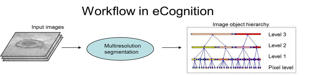
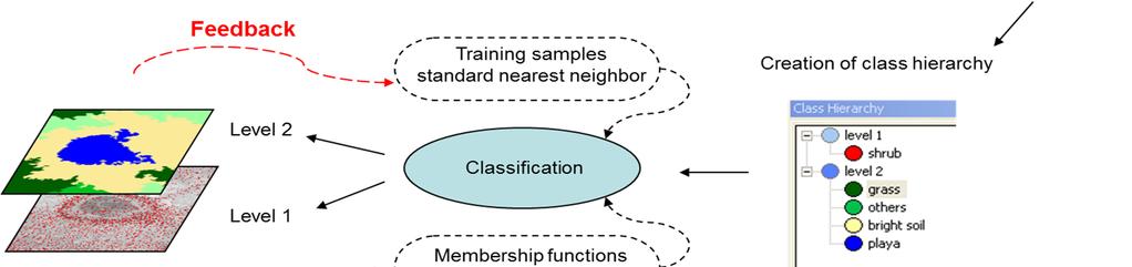
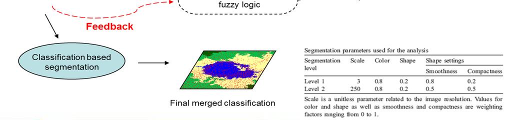
10 Overall methodology to identify and map HNV farmlands with remote sensing images Image segmentations based on farm boundaries Simplify the image into meaningful pixel groupings (i.e., segments/objects) Region-based category, where image objects are generated according to a certain homogeneity criteria of the spatial object (shape, colour, texture etc) Multiresolution Segmentation of the image using ecognition software Classify HNV farms using fieldwork scores as ground-truthing data Produce a map of the probable extent and distribution of HNV farmland
11 Image segmentations based on farm boundariesecognition software o Scale (Low weightage) o Colour (High weightage ) o Texture (Moderate weightage)
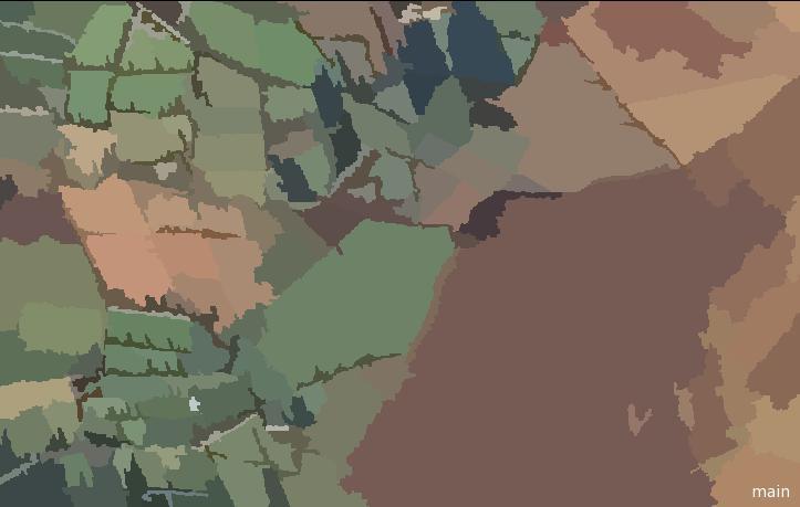
12 Object based-classified map

13 Pixel based-classified map As we increase the spatial resolution of image the intra-class variation increases and this property of class uniformity is broken leading to very poor performance

14 Test Site-1 SPOT 7, Comeragh MountainsLowlands

15 Image segmentations based on farm boundaries
16 Classified map
17 Test site-2 SPOT 7, Comeragh MountainsUplands

18 SPOT 7, Comeragh MountainsUplands
19
20 Identification of HNV farms Based on indicators like Intensity of land use Presence of semi-natural habitats Presence of land use mosaics (diversity in land use) and by excluding the non-hnv lands like built-up areas, water bodies, bare rocks, beaches, infrastructure and forests Auxiliary layers for enhancement of output and validation NIR bands (SPOT-7, landsat-8, and LISS-3) to create vegetation index layer LPIS data Ground truth data etc
21 Final output and Accuracy assessment HNV map at parcel level: It would give a greater degree of confidence in the output Final HNV status map at townland scale: Parcels will be aggregated to townland scale will also allow for the introduction of other, complementary datasets that can improve classification accuracy The accuracy testing of this task will be two-fold. 548 field parcel data information collected as ground truth An expert group will also be used to test the accuracy of the methodology.
22
23 Major segmentation criteria The scale parameter is an abstract value to determine the maximum possible change of heterogeneity caused by fusing several objects. The scale parameter is indirectly related to the size of the created objects. The heterogeneity at a given scale parameter is directly dependent on the object size. Homogeneous areas result in larger objects, and heterogeneous areas result in small objects. Small scale number results small objects, lager scale number results in larger objects. This refers to Multiresolution image segmentation. Color is the pixel value; Shape includes compactness and smoothness which are two geometric features that can be used as "evidence." Smoothness describes the similarity between the image object borders Compactness describes the "closeness" of pixels clustered in an object


24 Issues in developing rule set Shadow removal by pixel matching Different field shape and size

25 Issues in developing rule set Exact identification of HNV farmlands Difference between lowland and upland farms
26 Expected output Working to develop a ruleset that can be apply to Comeragh mountains for HNV identification A similar ruleset with more parameters for the entire country Methodology development with Spot data HNVf identification based on HNV probability not on field boundary
27 Your Suggestion and Feedback Thanks..
Possible links between a sample of VHR images and LUCAS
 EUROPEAN COMMISSION EUROSTAT Directorate E: Sectoral and regional statistics Unit E-1: Farms, agro-environment and rural development CPSA/LCU/08 Original: EN (available in EN) WORKING PARTY "LAND COVER/USE
COMPARISON OF PIXEL-BASED AND OBJECT-BASED CLASSIFICATION METHODS FOR SEPARATION OF CROP PATTERNS
 COMPARISON OF PIXEL-BASED AND OBJECT-BASED CLASSIFICATION METHODS FOR SEPARATION OF CROP PATTERNS Levent BAŞAYİĞİT, Rabia ERSAN Suleyman Demirel University, Agriculture Faculty, Soil Science and Plant
SIF_7.1_v2. Indicator. Measurement. What should the measurement tell us?
 Indicator 7 Area of natural and semi-natural habitat Measurement 7.1 Area of natural and semi-natural habitat What should the measurement tell us? Natural habitats are considered the land and water areas
LAND COVER CHANGES IN ROMANIA BASED ON CORINE LAND COVER INVENTORY
 LAND COVER CHANGES IN ROMANIA BASED ON CORINE LAND COVER INVENTORY 1990 2012 JENICĂ HANGANU, ADRIAN CONSTANTINESCU * Key-words: CORINE Land Cover inventory, Land cover changes, GIS. Abstract. From 1990
DEVELOPMENT OF DIGITAL CARTOGRAPHIC DATABASE FOR MANAGING THE ENVIRONMENT AND NATURAL RESOURCES IN THE REPUBLIC OF SERBIA
 DEVELOPMENT OF DIGITAL CARTOGRAPHIC BASE FOR MANAGING THE ENVIRONMENT AND NATURAL RESOURCES IN THE REPUBLIC OF SERBIA Dragutin Protic, Ivan Nestorov Institute for Geodesy, Faculty of Civil Engineering,
An Update on Land Use & Land Cover Mapping in Ireland
 An Update on Land Use & Land Cover Mapping in Ireland Progress Towards a National Programme Kevin Lydon k.lydon@epa.ie Office of Environmental Assessment, Environmental Protection Agency, Johnstown Castle,
The Road to Data in Baltimore
 Creating a parcel level database from high resolution imagery By Austin Troy and Weiqi Zhou University of Vermont, Rubenstein School of Natural Resources State and local planning agencies are increasingly
Land cover research, applications and development needs in Slovakia
 Land cover research, applications and development needs in Slovakia Andrej Halabuk Institute of Landscape Ecology Slovak Academy of Sciences (ILE SAS) Štefánikova 3, 814 99 Bratislava, Slovakia Institute
Streamlining Land Change Detection to Improve Control Efficiency
 Streamlining Land Change Detection to Improve Control Efficiency Sanjay Rana sanjay.rana@rpa.gsi.gov.uk Rural Payments Agency Research and Development Teams Purpose The talk presents the methodology and
Accounting for Ecosystem and Biodiversity Related Themes in Uganda
 Introduction Accounting for Ecosystem and Biodiversity Related Themes in Uganda Calls for more evidence-based approaches to policy have increased the need for integrated environmental-economic information
UK Contribution to the European CORINE Land Cover
 Centre for Landscape andwww.le.ac.uk/clcr Climate Research CENTRE FOR Landscape and Climate Research UK Contribution to the European CORINE Land Cover Dr Beth Cole Corine Coordination of Information on
An Automated Object-Oriented Satellite Image Classification Method Integrating the FAO Land Cover Classification System (LCCS).
.") An Automated Object-Oriented Satellite Image Classification Method Integrating the FAO Land Cover Classification System (LCCS). Ruvimbo Gamanya Sibanda Prof. Dr. Philippe De Maeyer Prof. Dr. Morgan De
An Automated Object-Oriented Satellite Image Classification Method Integrating the FAO Land Cover Classification System (LCCS). Ruvimbo Gamanya Sibanda Prof. Dr. Philippe De Maeyer Prof. Dr. Morgan De
SPLAN-Natura Towards an integrated spatial planning approach for Natura th January, 2017 Brussels. Commissioned by DG Environment
 SPLAN-Natura 2000 Towards an integrated spatial planning approach for Natura 2000 Commissioned by DG Environment 17 th January, 2017 Brussels V. Simeonova (Ph.D.) Drivers towards integrating Biodiversity
IMPROVING REMOTE SENSING-DERIVED LAND USE/LAND COVER CLASSIFICATION WITH THE AID OF SPATIAL INFORMATION
 IMPROVING REMOTE SENSING-DERIVED LAND USE/LAND COVER CLASSIFICATION WITH THE AID OF SPATIAL INFORMATION Yingchun Zhou1, Sunil Narumalani1, Dennis E. Jelinski2 Department of Geography, University of Nebraska,
AN INVESTIGATION OF AUTOMATIC CHANGE DETECTION FOR TOPOGRAPHIC MAP UPDATING
 AN INVESTIGATION OF AUTOMATIC CHANGE DETECTION FOR TOPOGRAPHIC MAP UPDATING Patricia Duncan 1 & Julian Smit 2 1 The Chief Directorate: National Geospatial Information, Department of Rural Development and
Module 2.1 Monitoring activity data for forests using remote sensing
 Module 2.1 Monitoring activity data for forests using remote sensing Module developers: Frédéric Achard, European Commission (EC) Joint Research Centre (JRC) Jukka Miettinen, EC JRC Brice Mora, Wageningen
C o p e r n i c u s L a n d M o n i t o r i n g S e r v i c e
 C o p e r n i c u s L a n d M o n i t o r i n g S e r v i c e Submodule D: stability of protected areas & related pressures: Natura2000 sites Copernicus EU Copernicus EU Copernicus EU www.copernicus.eu
Preparation of LULC map from GE images for GIS based Urban Hydrological Modeling
 International Conference on Modeling Tools for Sustainable Water Resources Management Department of Civil Engineering, Indian Institute of Technology Hyderabad: 28-29 December 2014 Abstract Preparation
Land accounting perspective on water resources management
 European Water 60: 161-166, 2017. 2017 E.W. Publications Land accounting perspective on water resources management G.T. Paschos, G.E. Bariamis * and E.A. Baltas Department of Water Resources and Environmental
FOREST CHANGE DETECTION BY MEANS OF REMOTE SENSING TECHNIQUES FROM THE EU PROJECT CORINE LAND COVER
 FORESTRY IDEAS, 2010, vol. 16, 1 (39) FOREST CHANGE DETECTION BY MEANS OF REMOTE SENSING TECHNIQUES FROM THE EU PROJECT CORINE LAND COVER Youlin Tepeliev and Radka Koleva* University of Forestry, Faculty
Object-based classification of residential land use within Accra, Ghana based on QuickBird satellite data
 International Journal of Remote Sensing Vol. 28, No. 22, 20 November 2007, 5167 5173 Letter Object-based classification of residential land use within Accra, Ghana based on QuickBird satellite data D.
Are EU Rural Areas still Lagging behind Urban Regions? An Analysis through Fuzzy Logic
 Are EU Rural Areas still Lagging behind Urban Regions? An Analysis through Fuzzy Logic Francesco Pagliacci Department of Economics and Social Sciences Università Politecnica delle Marche Ancona (Italy)
Directorate E: Sectoral and regional statistics Unit E-4: Regional statistics and geographical information LUCAS 2018.
 EUROPEAN COMMISSION EUROSTAT Directorate E: Sectoral and regional statistics Unit E-4: Regional statistics and geographical information Doc. WG/LCU 52 LUCAS 2018 Eurostat Unit E4 Working Group for Land
COMBINING ENUMERATION AREA MAPS AND SATELITE IMAGES (LAND COVER) FOR THE DEVELOPMENT OF AREA FRAME (MULTIPLE FRAMES) IN AN AFRICAN COUNTRY:
 FOR THE DEVELOPMENT OF AREA FRAME (MULTIPLE FRAMES) IN AN AFRICAN COUNTRY:") COMBINING ENUMERATION AREA MAPS AND SATELITE IMAGES (LAND COVER) FOR THE DEVELOPMENT OF AREA FRAME (MULTIPLE FRAMES) IN AN AFRICAN COUNTRY: PRELIMINARY LESSONS FROM THE EXPERIENCE OF ETHIOPIA BY ABERASH
COMBINING ENUMERATION AREA MAPS AND SATELITE IMAGES (LAND COVER) FOR THE DEVELOPMENT OF AREA FRAME (MULTIPLE FRAMES) IN AN AFRICAN COUNTRY: PRELIMINARY LESSONS FROM THE EXPERIENCE OF ETHIOPIA BY ABERASH
USE OF RADIOMETRICS IN SOIL SURVEY
 USE OF RADIOMETRICS IN SOIL SURVEY Brian Tunstall 2003 Abstract The objectives and requirements with soil mapping are summarised. The capacities for different methods to address these objectives and requirements
Object-Oriented Oriented Method to Classify the Land Use and Land Cover in San Antonio using ecognition Object-Oriented Oriented Image Analysis
 Object-Oriented Oriented Method to Classify the Land Use and Land Cover in San Antonio using ecognition Object-Oriented Oriented Image Analysis Jayar S. Griffith ES6973 Remote Sensing Image Processing
Estimation of the area of sealed soil using GIS technology and remote sensing
 From the SelectedWorks of Przemysław Kupidura 2010 Estimation of the area of sealed soil using GIS technology and remote sensing Stanisław Białousz Przemysław Kupidura Available at: https://works.bepress.com/przemyslaw_kupidura/14/
Discussion paper on spatial units
 Discussion paper on spatial units for the Forum of Experts in SEEA Experimental Ecosystem Accounting 2018 Version: 8 June 2018 Prepared by: SEEA EEA Revision Working Group 1 on spatial units (led by Sjoerd
Management Planning & Implementation of Communication Measures for Terrestrial Natura 2000 Sites in the Maltese Islands Epsilon-Adi Consortium
 Management Planning & Implementation of Communication Measures for Terrestrial Natura 2000 Sites in the Maltese Islands Epsilon-Adi Consortium Briefing Meetings, February 2013 CT3101/2011, MEPA, Malta
MANUAL ON THE BSES: LAND USE/LAND COVER
 6. Environment Protection, Management and Engagement 2. Environmental Resources and their Use 5. Human Habitat and Environmental Health 1. Environmental Conditions and Quality 4. Disasters and Extreme
LAND COVER CATEGORY DEFINITION BY IMAGE INVARIANTS FOR AUTOMATED CLASSIFICATION
 LAND COVER CATEGORY DEFINITION BY IMAGE INVARIANTS FOR AUTOMATED CLASSIFICATION Nguyen Dinh Duong Environmental Remote Sensing Laboratory Institute of Geography Hoang Quoc Viet Rd., Cau Giay, Hanoi, Vietnam
C N E S, U M R I R I S A
 M O N I T O R I N G U R B A N A R E A S W I T H S E N T I N E L - 2. APPLICATION TO THE UPDATE OF THE COPERNICUS HIGH RESOLUTION LAYER IMPERVIOUSNESS DEGREE O c t o b e r 2 5 th 2016, Brussels A n t o
CORINE LAND COVER CROATIA
 CORINE LAND COVER CROATIA INTRO Primary condition in making decisions directed to land cover and natural resources management is presence of knowledge and high quality information about biosphere and its
Copernicus Land HRL Imperviousness: 2012 dataset, indicator Title
 Copernicus Land HRL Imperviousness: 2012 dataset, 06-09 indicator and outlook Title 2015+ Tobias LANGANKE First name SURNAME Project manager, Copernicus Position land services Name European of the Environment
Measuring Urban Sprawl A Case Study of China
 Institute for Regional Development Planning, University of Stuttgart Applying Remote Sensing and GIS on Monitoring and Measuring Urban Sprawl A Case Study of China Outline Research hbackground and dobjectives
OBJECT-BASED CLASSIFICATION USING HIGH RESOLUTION SATELLITE DATA AS A TOOL FOR MANAGING TRADITIONAL JAPANESE RURAL LANDSCAPES
 OBJECT-BASED CLASSIFICATION USING HIGH RESOLUTION SATELLITE DATA AS A TOOL FOR MANAGING TRADITIONAL JAPANESE RURAL LANDSCAPES K. Takahashi a, *, N. Kamagata a, K. Hara b a Graduate School of Informatics,
HNV Farming in Italy Context indicator CI37 Land cover approach
 Good Practice Workshop, Bonn 7-8 June 2016 Preparing the assessment of High Nature Value Farming in Rural Development Programmes 2014-2020 HNV Farming in Italy Context indicator CI37 Land cover approach
UNSD SEEA-EEA revision 2020
 UNSD SEEA-EEA revision 2020 Area 1: Spatial units; introduction Sjoerd Schenau, Patrick Bogaart, Edwin Horlings London group meeting, October 2018 Overview Spatial units in SEEA EEA Main revision issues
The Combination of Geospatial Data with Statistical Data for SDG Indicators
 Session x: Sustainable Development Goals, SDG indicators The Combination of Geospatial Data with Statistical Data for SDG Indicators Pier-Giorgio Zaccheddu Fabio Volpe 5-8 December2018, Nairobi IAEG SDG
Spanish national plan for land observation: new collaborative production system in Europe
 ADVANCE UNEDITED VERSION UNITED NATIONS E/CONF.103/5/Add.1 Economic and Social Affairs 9 July 2013 Tenth United Nations Regional Cartographic Conference for the Americas New York, 19-23, August 2013 Item
Classification of High Spatial Resolution Remote Sensing Images Based on Decision Fusion
 Journal of Advances in Information Technology Vol. 8, No. 1, February 2017 Classification of High Spatial Resolution Remote Sensing Images Based on Decision Fusion Guizhou Wang Institute of Remote Sensing
Habitat Mapping using Remote Sensing for Green Infrastructure Planning in Anguilla
 Habitat Mapping using Remote Sensing for Green Infrastructure Planning in Anguilla Dr Katie Medcalf Cenv MIEEM www.envsys.co.uk Context Introduction to Anguilla Habitat mapping using Earth Observation
European Topic Centre on Land Urban and Soil Systems. Green Infrastructure at EEA
 Green Infrastructure at EEA A SPATIAL APPROACH TO MAPPING GI Stefan Kleeschulte, ETC ULS GI and territorial cohesion 2011 first EEA report on Green Infrastructure Underlining the need to develop tools
Vegetation Change Detection of Central part of Nepal using Landsat TM
 Vegetation Change Detection of Central part of Nepal using Landsat TM Kalpana G. Bastakoti Department of Geography, University of Calgary, kalpanagb@gmail.com Abstract This paper presents a study of detecting
Accounting Units for Ecosystem Accounts Paper prepared by Alessandra Alfieri, Daniel Clarke, and Ivo Havinga United Nations Statistics Division
 DEPARTMENT OF ECONOMIC AND SOCIAL AFFAIRS STATISTICS DIVISION UNITED NATIONS Expert Meeting on Ecosystem Accounts London, UK 5-7 December 2011 Accounting Units for Ecosystem Accounts Paper prepared by
AUTOMATIC EXTRACTION OF ALUVIAL FANS FROM ASTER L1 SATELLITE DATA AND A DIGITAL ELEVATION MODEL USING OBJECT-ORIENTED IMAGE ANALYSIS
 AUTOMATIC EXTRACTION OF ALUVIAL FANS FROM ASTER L1 SATELLITE DATA AND A DIGITAL ELEVATION MODEL USING OBJECT-ORIENTED IMAGE ANALYSIS Demetre P. Argialas, Angelos Tzotsos Laboratory of Remote Sensing, Department
Rating of soil heterogeneity using by satellite images
 Rating of soil heterogeneity using by satellite images JAROSLAV NOVAK, VOJTECH LUKAS, JAN KREN Department of Agrosystems and Bioclimatology Mendel University in Brno Zemedelska 1, 613 00 Brno CZECH REPUBLIC
Natura 2000 and spatial planning. Executive summary
 Natura 2000 and spatial planning Executive summary DISCLAIMER The information and views set out in this study are those of the author(s) and do not necessarily reflect the official opinion of the Commission.
Trimble s ecognition Product Suite
 Trimble s ecognition Product Suite Dr. Waldemar Krebs October 2010 Trimble Geospatial in the Image Processing Chain Data Acquisition Pre-processing Manual/Pixel-based Object-/contextbased Interpretation
Monitoring of Tropical Deforestation and Land Cover Changes in Protected Areas: JRC Perspective
 Monitoring of Tropical Deforestation and Land Cover Changes in Protected Areas: JRC Perspective Z. Szantoi, A. Brink, P. Mayaux, F. Achard Monitoring Of Natural resources for DEvelopment (MONDE) Joint
Outline: Introduction - Data used - Methods - Results
 Mapping of land covers in South Greenland using very high resolution satellite imagery Menaka Chellasamy, Mateja Ogric, Mogens H. Greve and René Larsen Outline: Introduction - Data used - Methods - Results
HELSINKI COMMISSION Baltic Marine Environment Protection Commission
 HELSINKI COMMISSION Baltic Marine Environment Protection Commission HELCOM RECOMMENDATION 24/10 Adopted 25 June 2003, having regard to Article 20, Paragraph 1 b) of the 1992 Helsinki Convention IMPLEMENTATION
REMOTE SENSING APPLICATION IN FOREST MONITORING: AN OBJECT BASED APPROACH Tran Quang Bao 1 and Nguyen Thi Hoa 2
 REMOTE SENSING APPLICATION IN FOREST MONITORING: AN OBJECT BASED APPROACH Tran Quang Bao 1 and Nguyen Thi Hoa 2 1 Department of Environment Management, Vietnam Forestry University, Ha Noi, Vietnam 2 Institute
Habitats habitat concept, identification, methodology for habitat mapping, organization of mapping
 Habitats habitat concept, identification, methodology for habitat mapping, organization of mapping Rastislav Lasák & Ján Šeffer Training Implementation of Habitats Directive - Habitats and Plants 1 What
Spatial metrics for Greek cities using land cover information from the Urban Atlas
 Spatial metrics for Greek cities using land cover information from the Urban Atlas Poulicos Prastacos IACM-FORTH P.O. Box 1385 Heraklion, Greece poulicos@iacm.forth.gr Nektarios Chrysoulakis IACM-FORTH
The Combination of Geospatial Data with Statistical Data for SDG Indicators
 Session 3: Sustainable Development Goals, SDG indicators The Combination of Geospatial Data with Statistical Data for SDG Indicators Pier-Giorgio Zaccheddu (with the assistance of Francisco Vala & Cátia
Application of Remote Sensing Techniques for Change Detection in Land Use/ Land Cover of Ratnagiri District, Maharashtra
 IOSR Journal of Applied Geology and Geophysics (IOSR-JAGG) e-issn: 2321 0990, p-issn: 2321 0982.Volume 3, Issue 6 Ver. II (Nov. - Dec. 2015), PP 55-60 www.iosrjournals.org Application of Remote Sensing
Route to Biotope Data Standardization for the Protected Areas in Turkey
 INSPIRE 2016 CONFERENCE Directorate General for Protection of Natural Assets Directorate General of Geographical Information Systems Route to Biotope Data Standardization for the Protected Areas in Turkey
ARCH PROJET Activity 1 -Synthesis-
 ARCH PROJET Activity 1 -Synthesis- CONTENT 1 ARCH project context... 3 1.1. General context... 3 1.2. The ARCH Project... 3 1.3. The Project ARCH partners... 3 1.4. The ARCH project content... 4 2 Activity
Case Study: Ecological Integrity of Grasslands in the Apache Highlands Ecoregion
 Standard 9: Screen all target/biodiversity element occurrences for viability or ecological integrity. Case Study: Ecological Integrity of Grasslands in the Apache Highlands Ecoregion Summarized from: Marshall,
Land Use MTRI Documenting Land Use and Land Cover Conditions Synthesis Report
 Colin Brooks, Rick Powell, Laura Bourgeau-Chavez, and Dr. Robert Shuchman Michigan Tech Research Institute (MTRI) Project Introduction Transportation projects require detailed environmental information
AUTOMATED BUILDING DETECTION FROM HIGH-RESOLUTION SATELLITE IMAGE FOR UPDATING GIS BUILDING INVENTORY DATA
 13th World Conference on Earthquake Engineering Vancouver, B.C., Canada August 1-6, 2004 Paper No. 678 AUTOMATED BUILDING DETECTION FROM HIGH-RESOLUTION SATELLITE IMAGE FOR UPDATING GIS BUILDING INVENTORY
AUTOMATIC LAND-COVER CLASSIFICATION OF LANDSAT IMAGES USING FEATURE DATABASE IN A NETWORK
 AUTOMATIC LAND-COVER CLASSIFICATION OF LANDSAT IMAGES USING FEATURE DATABASE IN A NETWORK G. W. Yoon*, S. I. Cho, G. J. Chae, J. H. Park ETRI Telematics Research Group, Daejeon, Korea (gwyoon, chosi, cbase,
Standardization of the land cover classes using FAO Land Cover Classification System (LCCS)
") Sofia, 17-18 September 2008, LPIS Workshop LPIS applications and quality 1 Standardization of the land cover classes using FAO Land Cover Classification System (LCCS) Pavel MILENOV Agriculture Unit, JRC
Sofia, 17-18 September 2008, LPIS Workshop LPIS applications and quality 1 Standardization of the land cover classes using FAO Land Cover Classification System (LCCS) Pavel MILENOV Agriculture Unit, JRC
EuroGEOSS Protected Areas Pilot
 EuroGEOSS Protected Areas Pilot Max Craglia European Commission Joint Research Centre Part 1: the present MyNatura2000 Mobile app. Awareness raising & volunteered data collection. Natura2000 covers 18%
What is a compact city? How could it be measured?
 What is a compact city? How could it be measured? Madhu Singh Transport Planner Directorate of Urban Land Transport, Bangalore Guided By: Professor H. M. Shivanand Swamy CEPT University, Ahmedabad Cities
Managing uncertainty when aggregating from pixels to parcels: context sensitive mapping and possibility theory
 Department of Geography Managing uncertainty when aggregating from pixels to parcels: context sensitive mapping and possibility theory Dr Lex Comber ajc36@le.ac.uk www.le.ac.uk/gg/staff/academic_comber.htm
A Help Guide for Using gssurgo to Find Potential Wetland Soil Landscapes
 A Help Guide for Using gssurgo to Find Potential Wetland Soil Landscapes Wetland Mapping Consortium Webinar September 17, 2014 Dr. John M. Galbraith Crop & Soil Environmental Sciences Virginia Tech Wetland
Land cover classification of QuickBird multispectral data with an object-oriented approach
 Land cover classification of QuickBird multispectral data with an object-oriented approach E. Tarantino Polytechnic University of Bari, Italy Abstract Recent satellite technologies have produced new data
Potential Open Space Detection and Decision Support for Urban Planning by Means of Optical VHR Satellite Imagery
 Remote Sensing and Geoinformation Lena Halounová, Editor not only for Scientific Cooperation EARSeL, 2011 Potential Open Space Detection and Decision Support for Urban Planning by Means of Optical VHR
A Case Study of Using Remote Sensing Data and GIS for Land Management; Catalca Region
 A Case Study of Using Remote Sensing Data and GIS for Land Management; Catalca Region Dr. Nebiye MUSAOGLU, Dr. Sinasi KAYA, Dr. Dursun Z. SEKER and Dr. Cigdem GOKSEL, Turkey Key words: Satellite data,
Ecosystem Indicators. Age Poom. Environmental Management Master Course CAU Ecology Centre SS 2006
 Ecosystem Indicators Age Poom Environmental Management Master Course CAU Ecology Centre SS 2006 Indicator definitions Purpose of development and use of indicators Characteristics and requirements of indicators
Land Cover and Land Use Diversity Indicators in LUCAS 2009 data
 Land Cover and Land Use Diversity Indicators in LUCAS 2009 data A. Palmieri, L. Martino, P. Dominici and M. Kasanko Abstract Landscape diversity and changes are connected to land cover and land use. The
Green areas: numerous positive effects for sustainable metropolis Satellite images : an easy way to map vegetation
 Green areas: numerous positive effects for sustainable metropolis Satellite images : an easy way to map vegetation Copernicus Training and Information Session 10 and 11 may 2017 in Lund, Sweden Dominique
Abstract: About the Author:
 REMOTE SENSING AND GIS IN LAND USE PLANNING Sathees kumar P 1, Nisha Radhakrishnan 2 1 1 Ph.D Research Scholar, Department of Civil Engineering, National Institute of Technology, Tiruchirappalli- 620015,
The Self-adaptive Adjustment Method of Clustering Center in Multi-spectral Remote Sensing Image Classification of Land Use
 The Self-adaptive Adjustment Method of Clustering Center in Multi-spectral Remote Sensing Image Classification of Land Use Shujing Wan 1,Chengming Zhang(*) 1,2, Jiping Liu 2, Yong Wang 2, Hui Tian 1, Yong
Mapping granite outcrops in the Western Australian Wheatbelt using Landsat TM data
 Journal of the Royal Society of Western Australia, 109-113, 2000 Mapping granite outcrops in the Western Australian Wheatbelt using Landsat TM data N A Campbell 1, S D Hopper 2 & P A Caccetta 1 1 CSIRO
Modelling of the Interaction Between Urban Sprawl and Agricultural Landscape Around Denizli City, Turkey
 Modelling of the Interaction Between Urban Sprawl and Agricultural Landscape Around Denizli City, Turkey Serhat Cengiz, Sevgi Gormus, Şermin Tagil srhtcengiz@gmail.com sevgigormus@gmail.com stagil@balikesir.edu.tr
Adding value to Copernicus services with member states reference data
 www.eurogeographics.org Adding value to Copernicus services with member states reference data Neil Sutherland neil.sutherland@os.uk GIS in the EU 10 November 2016 Copyright 2016 EuroGeographics 61 member
Contemporary Data Collection and Spatial Information Management Techniques to support Good Land Policies
 Contemporary Data Collection and Spatial Information Management Techniques to support Good Land Policies Ch. Ioannidis Associate Professor FIG Commission 3 Workshop Paris, 25-28 October 2011 Introduction
FRAGMENTATION OF LANDSCAPES WITH CONSERVATION VALUE IN SOUTH PIRIN AND SLAVYANKA MOUNTAIN (SOUTH-WESTERN BULGARIA)
") FRAGMENTATION OF LANDSCAPES WITH CONSERVATION VALUE IN SOUTH PIRIN AND SLAVYANKA MOUNTAIN (SOUTH-WESTERN BULGARIA) Atanas Kitev, Rumiana Vatseva Assist. Prof. Atanas Kitev, Ph.D.; Prof. Rumiana Vatseva,
FRAGMENTATION OF LANDSCAPES WITH CONSERVATION VALUE IN SOUTH PIRIN AND SLAVYANKA MOUNTAIN (SOUTH-WESTERN BULGARIA) Atanas Kitev, Rumiana Vatseva Assist. Prof. Atanas Kitev, Ph.D.; Prof. Rumiana Vatseva,
Open call for tenders No EEA/MDI/14/001
 1 April 2014 Clarification No 1 Reference: Title: Open call for tenders No EEA/MDI/14/001 Copernicus Initial Operations 2011-2013 - Land Monitoring Service Local Component: riparian zones Question 1 Section
International Journal of Remote Sensing, in press, 2006.
 International Journal of Remote Sensing, in press, 2006. Parameter Selection for Region-Growing Image Segmentation Algorithms using Spatial Autocorrelation G. M. ESPINDOLA, G. CAMARA*, I. A. REIS, L. S.
Establishment of the Hellenic Ecosystem Services Partnership (HESP) research group: Drafting the national agenda for the implementation of the
 research group: Drafting the national agenda for the implementation of the") Establishment of the Hellenic Ecosystem Services Partnership (HESP) research group: Drafting the national agenda for the implementation of the ES concept in Greece Establishment of the Hellenic Ecosystem
Establishment of the Hellenic Ecosystem Services Partnership (HESP) research group: Drafting the national agenda for the implementation of the ES concept in Greece Establishment of the Hellenic Ecosystem
New approach for land use mapping in the Netherlands (LGN6)
") New approach for land use mapping in the Netherlands (LGN6) Gerard Hazeu & Rini Schuiling Content Objectives Background LGN and its history National and European activities (e.g. INSPIRE) Methodology LGN6
New approach for land use mapping in the Netherlands (LGN6) Gerard Hazeu & Rini Schuiling Content Objectives Background LGN and its history National and European activities (e.g. INSPIRE) Methodology LGN6
Parameter selection for region-growing image segmentation algorithms using spatial autocorrelation
 International Journal of Remote Sensing Vol. 27, No. 14, 20 July 2006, 3035 3040 Parameter selection for region-growing image segmentation algorithms using spatial autocorrelation G. M. ESPINDOLA, G. CAMARA*,
Evaluating Urban Vegetation Cover Using LiDAR and High Resolution Imagery
 Evaluating Urban Vegetation Cover Using LiDAR and High Resolution Imagery Y.A. Ayad and D. C. Mendez Clarion University of Pennsylvania Abstract One of the key planning factors in urban and built up environments
Plan4all (econtentplus project)
") Plan4all (econtentplus project) Karel CHARVAT 1, Tomáš MILDORF 2 1 Help service remote sensing, Ltd., Černoleská 1600, 256 01 Benešov u Prahy, Czech Republic charvat@bnhelp.cz 2 Department of Mathematics
Plan4all (econtentplus project) Karel CHARVAT 1, Tomáš MILDORF 2 1 Help service remote sensing, Ltd., Černoleská 1600, 256 01 Benešov u Prahy, Czech Republic charvat@bnhelp.cz 2 Department of Mathematics
High resolution mapping of urban areas using SPOT-5 images and ancillary data
 International Journal of Environment and Geoinformatics 2(2), 63-76 (2015) High resolution mapping of urban areas using SPOT-5 images and ancillary data Elif Sertel 1*, Semih Sami Akay 2 1 Istanbul Technical
e-soter Regional pilot platform as EU contribution to a Global Soil Observing System
 e-soter Regional pilot platform as EU contribution to a Global Soil Observing System Enhancing the terrain component in SOTER database Joanna Zawadzka Overview Overview of tested methods for terrain analysis
The National Spatial Strategy
 Purpose of this Consultation Paper This paper seeks the views of a wide range of bodies, interests and members of the public on the issues which the National Spatial Strategy should address. These views
Cloud analysis from METEOSAT data using image segmentation for climate model verification
 Cloud analysis from METEOSAT data using image segmentation for climate model verification R. Huckle 1, F. Olesen 2 Institut für Meteorologie und Klimaforschung, 1 University of Karlsruhe, 2 Forschungszentrum
How rural the EU RDP is? An analysis through spatial funds allocation
 How rural the EU RDP is? An analysis through spatial funds allocation Beatrice Camaioni, Roberto Esposti, Antonello Lobianco, Francesco Pagliacci, Franco Sotte Department of Economics and Social Sciences
Reassessing the conservation status of the giant panda using remote sensing
 SUPPLEMENTARY Brief Communication INFORMATION DOI: 10.1038/s41559-017-0317-1 In the format provided by the authors and unedited. Reassessing the conservation status of the giant panda using remote sensing
Developing urban ecosystem accounts for Great Britain. Emily Connors Head of Natural Capital Accounting Office for National Statistics (UK)
") Developing urban ecosystem accounts for Great Britain Emily Connors Head of Natural Capital Accounting Office for National Statistics (UK) UN 2014 UN 2014 ONS 2017 UK motivation 54% 82% 5,900 Of the world
Developing urban ecosystem accounts for Great Britain Emily Connors Head of Natural Capital Accounting Office for National Statistics (UK) UN 2014 UN 2014 ONS 2017 UK motivation 54% 82% 5,900 Of the world
The Governance of Land Use
 The planning system Levels of government and their responsibilities The Governance of Land Use COUNTRY FACT SHEET NORWAY Norway is a unitary state with three levels of government; the national level, 19
Key Indicators for Territorial Cohesion & Spatial Planning Stakeholder Workshop - Project Update. 13 th December 2012 San Sebastián, Basque Country
 Key Indicators for Territorial Cohesion & Spatial Planning Stakeholder Workshop - Project Update 13 th December 2012 San Sebastián, Basque Country Key Aims Explore the use of territorial data in developing
Image Interpretation and Landscape Analysis: The Verka River Valley
 Image Interpretation and Landscape Analysis: The Verka River Valley Terms of reference Background The local government for the region of Scania has a need for improving the knowledge about current vegetation
Urban land cover and land use extraction from Very High Resolution remote sensing imagery
 Urban land cover and land use extraction from Very High Resolution remote sensing imagery Mengmeng Li* 1, Alfred Stein 1, Wietske Bijker 1, Kirsten M.de Beurs 2 1 Faculty of Geo-Information Science and
An Internet-based Agricultural Land Use Trends Visualization System (AgLuT)
") An Internet-based Agricultural Land Use Trends Visualization System (AgLuT) Prepared for Missouri Department of Natural Resources Missouri Department of Conservation 07-01-2000-12-31-2001 Submitted by
An Internet-based Agricultural Land Use Trends Visualization System (AgLuT) Prepared for Missouri Department of Natural Resources Missouri Department of Conservation 07-01-2000-12-31-2001 Submitted by