Measuring Urban Sprawl A Case Study of China
|
|
|
- Frederick Cannon
- 5 years ago
- Views:
Transcription
1 Institute for Regional Development Planning, University of Stuttgart Applying Remote Sensing and GIS on Monitoring and Measuring Urban Sprawl A Case Study of China
2 Outline Research hbackground and dobjectives Urban sprawl in perspective Research Area and Data Source Methodology of Research Results and Discussion
3 Research Background The understanding on urban sprawl in China still rest on qualitative discussion instead of quantitative analysis. There is no clear cea answer to identify sprawl and evaluate the extent tof sprawl To find good ways for analyzing the spatial features and unique mechanism of urban sprawl with Chinese context is very important
4 Research Objectives What happen? Monitoring urban sprawl in research area using remote sensing classified images and identifying the basic patterns of urban sprawl in research area. Why happen? Analysing the internal and external driver forces of urban sprawl and determining the main factors led to urban sprawl in research area. How happen? Reviewing on some methods for measurement urban sprawl and measuring the extent of urban sprawl using different dimensional indicators based on GIS in research area.

5 spreading from urban area to rural area uncontrolled or unplanned extension
6 Urban sprawl in perspectivep Across states and cities of Europe and North America there is a growing awareness of,and concern about urban sprawl. How to measure urban sprawl is becoming a hot spot of research. Some research organizations have put forward their indicators for measuring urban sprawl (Sierra Club,1998;USA Today,2001;Smart Growth American,2002;European Environment Agency,2006) Besides, many scholars focus on using indicators to measure urban sprawl by establishing i multi-dimensional i i indicatorsi by GS GIS analysis or descriptive i statistical i analysis (Nelson,1999;Kline J D, 2001; Paul M Torrens,2000; Kolankiewicz, et al., 2001; Galster et al.,2001; Ewing et al.,2002; Anthony,2004;Song et al.,2004;tsai,2005; 2005; Frenkel et al., 2005; Marjo Kasanko,2006; Scheider,A. et al.,2008; Siedentop,S. et al., 2008 )
7 Urban sprawl in perspective Until now, a lot of researches just focus on the urban expansion in China, few studies on measuring urban sprawl (Yeh and Li,2001; Jiang Fang et al.,2006;huang,2006;xi Jun Yu et al.,2007), ) In short, the research on urban sprawl in China is still in a preliminary stage, the basic characteristics of urban sprawl in China have no explicit expression, and the reveal of its internal mechanisms has been maintained in the level of empiricism


8 Research Area China Jiangning County Jiangsu Province Nanjing City


9 Research Area Urban sprawl in Europe identifying the challenge Dipl. Geogr. Stefan Feng Fina, li, Prof. Dr.-Ing. Stefan Siedentop
10 Data Source Name Spatial Resolution(m) Assess Time Remote Sensing Data TM 30m Other data Software ArcGIS 9.2 (ArcInfo) Erdas 8.7 Population data Socio-economic data


11 Landsat TM Images


12 Sub-images of research area
13 Methodology of Research Remote sensing The spatial patterns of urban sprawl over different time periods,can be monitored from remotely sensed data GIS Fundamental in analyzing land cover data,and in the calculation l of the indicators
14 Remote sensing image classification Remote sensing images Construction of Feature Space Choosing Training Area Not Satisfied Conditions Testing Training Results Satisfied Conditions MLC: Maximum Likelihood Classification i Classifying Pixel Category based on MLC Classification Results
15 Built-up area information extraction Remote Sensing Image Image Preprocessing Image Classification Built-up Area Extraction As indicator to measure urban sprawl


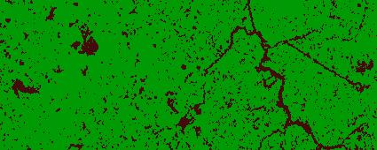


16 Classified images Build-up Area Water Area Other Areas
17 The patterns of urban sprawl Compact Scattere Linear Strip Polynucleated Leapfrogging development development development development development (From Galster et al., 2001)


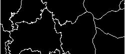
18 The patterns of urban sprawl in research area Sprawling area in the north part is larger than that in the southern Severer sprawling areas include the marginal area near suburbs, etc Three sprawling patterns are identified: randomly expansion at urban fringe, scattered development of industrial land and leapfrog development of urban residence area. 1979
19 Impact phenomena caused by changes of surface, land use pattern and ddensity surface-related impacts impacts/outcomes (examples) Loss/Degradation of Prime Farmland Surface Characteristics Landscape Fragmentation Negative impacts on aquatic systems Contribution to urban heat island density-related impacts Land Use Pattern Urban Density Higher development costs (infrastructure) Higher travel distances pattern-related impacts Less cost-efficient public transit Automobile dependence (From the research result of S.SIEDENTOP,S.FINA) SIEDENTOP S
20 Measuring urban sprawl using different indicators Indicators of Measuring Urban Sprawl Surface Pattern Density Total area Total built-up area The area change of built-up area The shape change of built-up area Fragmentation Open space efficiency Urban density The change of urban density
21 Results and Discussion High sprawl Moderate sprawl Low sprawl
22 Results and Discussion This study demonstrated that the application of remote sensing on monitoring the urban sprawl in different periods. Timely and accurate monitoring is very important to understand the relationships and interactions between human and natural phenomena and it can promote efficiency. GIS reveals spatial patterns of urban sprawl by measuring different dimensional indicators.
23 Many thanks for your attention!
Investigation of the Effect of Transportation Network on Urban Growth by Using Satellite Images and Geographic Information Systems
 Presented at the FIG Congress 2018, May 6-11, 2018 in Istanbul, Turkey Investigation of the Effect of Transportation Network on Urban Growth by Using Satellite Images and Geographic Information Systems
Using Geographic Information Systems and Remote Sensing Technology to Analyze Land Use Change in Harbin, China from 2005 to 2015
 Using Geographic Information Systems and Remote Sensing Technology to Analyze Land Use Change in Harbin, China from 2005 to 2015 Yi Zhu Department of Resource Analysis, Saint Mary s University of Minnesota,
Urban Growth Analysis: Calculating Metrics to Quantify Urban Sprawl
 Urban Growth Analysis: Calculating Metrics to Quantify Urban Sprawl Jason Parent jason.parent@uconn.edu Academic Assistant GIS Analyst Daniel Civco Professor of Geomatics Center for Land Use Education
What is a compact city? How could it be measured?
 What is a compact city? How could it be measured? Madhu Singh Transport Planner Directorate of Urban Land Transport, Bangalore Guided By: Professor H. M. Shivanand Swamy CEPT University, Ahmedabad Cities
URBAN CHANGE DETECTION OF LAHORE (PAKISTAN) USING A TIME SERIES OF SATELLITE IMAGES SINCE 1972
 USING A TIME SERIES OF SATELLITE IMAGES SINCE 1972") URBAN CHANGE DETECTION OF LAHORE (PAKISTAN) USING A TIME SERIES OF SATELLITE IMAGES SINCE 1972 Omar Riaz Department of Earth Sciences, University of Sargodha, Sargodha, PAKISTAN. omarriazpk@gmail.com ABSTRACT
URBAN CHANGE DETECTION OF LAHORE (PAKISTAN) USING A TIME SERIES OF SATELLITE IMAGES SINCE 1972 Omar Riaz Department of Earth Sciences, University of Sargodha, Sargodha, PAKISTAN. omarriazpk@gmail.com ABSTRACT
Analysis of urban sprawl phenomenon
 Analysis of urban sprawl phenomenon Detection of city growth based on spatiotemporal analysis and landscape metrics. Leopold Leśko University for Sustainable Development Eberswalde, 2013 Presentanion Outline
1. Introduction. Chaithanya, V.V. 1, Binoy, B.V. 2, Vinod, T.R. 2. Publication Date: 8 April DOI: https://doi.org/ /cloud.ijarsg.
 Cloud Publications International Journal of Advanced Remote Sensing and GIS 2017, Volume 6, Issue 1, pp. 2088-2096 ISSN 2320 0243, Crossref: 10.23953/cloud.ijarsg.112 Research Article Open Access Estimation
Object Oriented Classification Using High-Resolution Satellite Images for HNV Farmland Identification. Shafique Matin and Stuart Green
 Object Oriented Classification Using High-Resolution Satellite Images for HNV Farmland Identification Shafique Matin and Stuart Green REDP, Teagasc Ashtown, Dublin, Ireland Correspondence: shafique.matin@teagasc.ie
Applications of GIS and Remote Sensing for Analysis of Urban Heat Island
 Chuanxin Zhu Professor Peter V. August Professor Yeqiao Wang NRS 509 December 15, 2016 Applications of GIS and Remote Sensing for Analysis of Urban Heat Island Since the last century, the global mean surface
Geospatial Information for Urban Sprawl Planning and Policies Implementation in Developing Country s NCR Region: A Study of NOIDA City, India
 Geospatial Information for Urban Sprawl Planning and Policies Implementation in Developing Country s NCR Region: A Study of NOIDA City, India Dr. Madan Mohan Assistant Professor & Principal Investigator,
Urban Expansion of the City Kolkata since last 25 years using Remote Sensing
 [ VOLUME 5 I ISSUE 2 I APRIL JUNE 2018] E ISSN 2348 1269, PRINT ISSN 2349-5138 Urban Expansion of the City Kolkata since last 25 years using Remote Sensing Soumita Banerjee Researcher, Faculty Council
Urban Area Delineation Using Pattern Recognition Technique
 Cloud Publications International Journal of Advanced Remote Sensing and GIS 2018, Volume 7, Issue 1, pp. 2466-2470 ISSN 2320 0243, Crossref: 10.23953/cloud.ijarsg.333 Methodology Article Urban Area Delineation
Module 3 Indicator Land Consumption Rate to Population Growth Rate
 Regional Training Workshop on Human Settlement Indicators Module 3 Indicator 11.3.1 Land Consumption Rate to Population Growth Rate Dennis Mwaniki Global Urban Observatory, Research and Capacity Development
The suitability of GIS methods for analyzing urban sprawl, and the influence of scale. Dennis Weijers
 The suitability of GIS methods for analyzing urban sprawl, and the influence of scale. Dennis Weijers 2 The suitability of GIS methods for analyzing urban sprawl, and the influence of scale. MSc Thesis
Land cover/land use mapping and cha Mongolian plateau using remote sens. Title. Author(s) Bagan, Hasi; Yamagata, Yoshiki. Citation Japan.
 Bagan, Hasi; Yamagata, Yoshiki. Citation Japan.") Title Land cover/land use mapping and cha Mongolian plateau using remote sens Author(s) Bagan, Hasi; Yamagata, Yoshiki International Symposium on "The Imp Citation Region Specific Systems". 6 Nove Japan.
Title Land cover/land use mapping and cha Mongolian plateau using remote sens Author(s) Bagan, Hasi; Yamagata, Yoshiki International Symposium on "The Imp Citation Region Specific Systems". 6 Nove Japan.
IDENTIFICATION OF TRENDS IN LAND USE/LAND COVER CHANGES IN THE MOUNT CAMEROON FOREST REGION
 IDENTIFICATION OF TRENDS IN LAND USE/LAND COVER CHANGES IN THE MOUNT CAMEROON FOREST REGION By Nsorfon Innocent F. April 2008 Content Introduction Problem Statement Research questions/objectives Methodology
APPLICATION OF REMOTE SENSING IN LAND USE CHANGE PATTERN IN DA NANG CITY, VIETNAM
 APPLICATION OF REMOTE SENSING IN LAND USE CHANGE PATTERN IN DA NANG CITY, VIETNAM Tran Thi An 1 and Vu Anh Tuan 2 1 Department of Geography - Danang University of Education 41 Le Duan, Danang, Vietnam
Understanding and Measuring Urban Expansion
 VOLUME 1: AREAS AND DENSITIES 21 CHAPTER 3 Understanding and Measuring Urban Expansion THE CLASSIFICATION OF SATELLITE IMAGERY The maps of the urban extent of cities in the global sample were created using
Preparation of LULC map from GE images for GIS based Urban Hydrological Modeling
 International Conference on Modeling Tools for Sustainable Water Resources Management Department of Civil Engineering, Indian Institute of Technology Hyderabad: 28-29 December 2014 Abstract Preparation
Mapping the Urban Farming in Chinese Cities:
 Submission to EDC Student of the Year Award 2015 A old female is cultivating the a public green space in the residential community(xiaoqu in Chinese characters) Source:baidu.com 2015. Mapping the Urban
An Investigation of Urban form in Lahore and neighboring cities
 An Investigation of Urban form in Lahore and neighboring cities PRESENTER NAME: ENGR. MUHAMMAD KAMRAN Author Names: Engr. Muhammad Kamran Dr. Zahara Batool Engr. Umair Durrani Contents Introduction Literature
Modelling of the Interaction Between Urban Sprawl and Agricultural Landscape Around Denizli City, Turkey
 Modelling of the Interaction Between Urban Sprawl and Agricultural Landscape Around Denizli City, Turkey Serhat Cengiz, Sevgi Gormus, Şermin Tagil srhtcengiz@gmail.com sevgigormus@gmail.com stagil@balikesir.edu.tr
Unit 1, Lesson 3 What Tools and Technologies Do Geographers Use?
 Unit 1, Lesson 3 What Tools and Technologies Do Geographers Use? Geographers use a variety of tools and technologies in investigating geographic questions. Maps and globes both represent the earth, but
A Logistic Regression Method for Urban growth modeling Case Study: Sanandaj City in IRAN
 A Logistic Regression Method for Urban growth modeling Case Study: Sanandaj City in IRAN Sassan Mohammady GIS MSc student, Dept. of Surveying and Geomatics Eng., College of Eng. University of Tehran, Tehran,
Progress and Land-Use Characteristics of Urban Sprawl in Busan Metropolitan City using Remote sensing and GIS
 Progress and Land-Use Characteristics of Urban Sprawl in Busan Metropolitan City using Remote sensing and GIS Homyung Park, Taekyung Baek, Yongeun Shin, Hungkwan Kim ABSTRACT Satellite image is very usefully
APPLICATION OF LAND CHANGE MODELER FOR PREDICTION OF FUTURE LAND USE LAND COVER A CASE STUDY OF VIJAYAWADA CITY
 APPLICATION OF LAND CHANGE MODELER FOR PREDICTION OF FUTURE LAND USE LAND COVER A CASE STUDY OF VIJAYAWADA CITY K. Sundara Kumar 1, Dr. P. Udaya Bhaskar 2, Dr. K. Padmakumari 3 1 Research Scholar, 2,3
INTERNATIONAL JOURNAL OF GEOMATICS AND GEOSCIENCES Volume 7, No 1, 2016
 INTERNATIONAL JOURNAL OF GEOMATICS AND GEOSCIENCES Volume 7, No 1, 2016 Copyright by the authors - Licensee IPA- Under Creative Commons license 3.0 Research article ISSN 0976 4380 Urban sprawl and urban
Using Cellular Automaton to Simulate Urban Expansion in Changchun, China
 Sensors & Transducers 2014 by IFSA Publishing, S. L. http://www.sensorsportal.com Using Cellular Automaton to Simulate Urban Expansion in Changchun, China 1, 2 Jing MA, 3 Qiang BI, 4 Jingxia ZHANG, 1 Hongmei
Remote Sensing and GIS Application in Change Detection Study Using Multi Temporal Satellite
 Cloud Publications International Journal of Advanced Remote Sensing and GIS 2013, Volume 2, Issue 1, pp. 374-378, Article ID Tech-181 ISSN 2320-0243 Case Study Open Access Remote Sensing and GIS Application
CHAPTER 2 REMOTE SENSING IN URBAN SPRAWL ANALYSIS
 9 CHAPTER 2 REMOTE SENSING IN URBAN SPRAWL ANALYSIS 2.1. REMOTE SENSING Remote sensing is the science of acquiring information about the Earth's surface without actually being in contact with it. This
Measuring urban sprawl in China by night time light images
 IOP Conference Series: Earth and Environmental Science PAPER OPEN ACCESS Measuring urban sprawl in China by night time light images To cite this article: Lu Liu and Lin Tang 2017 IOP Conf. Ser.: Earth
Tackling urban sprawl: towards a compact model of cities? David Ludlow University of the West of England (UWE) 19 June 2014
 19 June 2014") Tackling urban sprawl: towards a compact model of cities? David Ludlow University of the West of England (UWE) 19 June 2014 Impacts on Natural & Protected Areas why sprawl matters? Sprawl creates environmental,
Tackling urban sprawl: towards a compact model of cities? David Ludlow University of the West of England (UWE) 19 June 2014 Impacts on Natural & Protected Areas why sprawl matters? Sprawl creates environmental,
Urban Growth and Transportation Development Patterns for China s Urban Transition
 Urban Growth and Transportation Development Patterns for China s Urban Transition Qisheng Pan Professor and Chair, Department of Urban Planning and Environmental Policy, Texas Southern University President,
MODELLING AND UNDERSTANDING MULTI-TEMPORAL LAND USE CHANGES
 MODELLING AND UNDERSTANDING MULTI-TEMPORAL LAND USE CHANGES Jianquan Cheng Department of Environmental & Geographical Sciences, Manchester Metropolitan University, John Dalton Building, Chester Street,
Applying SLEUTH for simulating urban expansion of Hangzhou
 Applying SLEUTH for simulating urban expansion of Hangzhou Yong Liu, Xiuhua Liu College of Resources and Environment, Southwest University, Chongqing, 4716, China ABSTRACT Urbanization is found to be closely
ScienceDirect. Local Climate Zone Study for Sustainable Megacities Development by Using Improved WUDAPT Methodology A Case Study in Guangzhou
 Available online at www.sciencedirect.com ScienceDirect Procedia Environmental Sciences 36 (2016 ) 82 89 International Conference on Geographies of Health and Living in Cities: Making Cities Healthy for
LAND USE AND LAND COVER CHANGE DETECTION AND URBAN SPRAWL ANALYSIS OF VIJAYAWADA CITY USING MULTITEMPORAL LANDSAT DATA
 LAND USE AND LAND COVER CHANGE DETECTION AND URBAN SPRAWL ANALYSIS OF VIJAYAWADA CITY USING MULTITEMPORAL LANDSAT DATA *K. SUNDARAKUMAR 1, M. HARIKA 2, SK. ASPIYA BEGUM 2, S. YAMINI 2, K. BALAKRISHNA 2
Digital Change Detection Using Remotely Sensed Data for Monitoring Green Space Destruction in Tabriz
 Int. J. Environ. Res. 1 (1): 35-41, Winter 2007 ISSN:1735-6865 Graduate Faculty of Environment University of Tehran Digital Change Detection Using Remotely Sensed Data for Monitoring Green Space Destruction
An Automated Object-Oriented Satellite Image Classification Method Integrating the FAO Land Cover Classification System (LCCS).
.") An Automated Object-Oriented Satellite Image Classification Method Integrating the FAO Land Cover Classification System (LCCS). Ruvimbo Gamanya Sibanda Prof. Dr. Philippe De Maeyer Prof. Dr. Morgan De
An Automated Object-Oriented Satellite Image Classification Method Integrating the FAO Land Cover Classification System (LCCS). Ruvimbo Gamanya Sibanda Prof. Dr. Philippe De Maeyer Prof. Dr. Morgan De
Unit 1, Lesson 2. What is geographic inquiry?
 What is geographic inquiry? Unit 1, Lesson 2 Understanding the way in which social scientists investigate problems will help you conduct your own investigations about problems or issues facing your community
ASSESSING THEMATIC MAP USING SAMPLING TECHNIQUE
 1 ASSESSING THEMATIC MAP USING SAMPLING TECHNIQUE University of Tehran, Faculty of Natural Resources, Karaj-IRAN E-Mail: adarvish@chamran.ut.ac.ir, Fax: +98 21 8007988 ABSTRACT The estimation of accuracy
ISoCaRP 44 th International Planning Congress. URBAN GROWTH WITHOUT SPRAWL: A WAY TOWARDS SUSTAINABLE URBANIZATION Dalian, China, September 2008
 ISoCaRP 44 th International Planning Congress URBAN GROWTH WITHOUT SPRAWL: A WAY TOWARDS SUSTAINABLE URBANIZATION Dalian, China, 19-23 September 2008 Urban competitiveness and sprawl as conflicting planning
M.C.PALIWAL. Department of Civil Engineering NATIONAL INSTITUTE OF TECHNICAL TEACHERS TRAINING & RESEARCH, BHOPAL (M.P.), INDIA
, INDIA") INVESTIGATIONS ON THE ACCURACY ASPECTS IN THE LAND USE/LAND COVER MAPPING USING REMOTE SENSING SATELLITE IMAGERY By M.C.PALIWAL Department of Civil Engineering NATIONAL INSTITUTE OF TECHNICAL TEACHERS
INVESTIGATIONS ON THE ACCURACY ASPECTS IN THE LAND USE/LAND COVER MAPPING USING REMOTE SENSING SATELLITE IMAGERY By M.C.PALIWAL Department of Civil Engineering NATIONAL INSTITUTE OF TECHNICAL TEACHERS
THE REVISION OF 1:50000 TOPOGRAPHIC MAP OF ONITSHA METROPOLIS, ANAMBRA STATE, NIGERIA USING NIGERIASAT-1 IMAGERY
 I.J.E.M.S., VOL.5 (4) 2014: 235-240 ISSN 2229-600X THE REVISION OF 1:50000 TOPOGRAPHIC MAP OF ONITSHA METROPOLIS, ANAMBRA STATE, NIGERIA USING NIGERIASAT-1 IMAGERY 1* Ejikeme, J.O. 1 Igbokwe, J.I. 1 Igbokwe,
THE BRAZILIAN HOUSING PROGRAM - MINHA CASA MINHA VIDA - EFFECT ON URBAN SPRAWL
 THE BRAZILIAN HOUSING PROGRAM - MINHA CASA MINHA VIDA - EFFECT ON URBAN SPRAWL Ciro Biderman Frederido Roman Ramos Martha Hanae Hiromoto EAESP/FGV March 20, 2018 The MCMV Program Main Characteristics From
Urban Sprawl Mapping and Landuse Change Detection in and around Udupi Town: A Remote Sensing based Approach
 Urban Sprawl Mapping and Landuse Change Detection in and around Udupi Town: A Remote Sensing based Approach 1 K. Silambarasan, 2 M. S. Vinaya, 3 S. Suresh Babu 1,2,3 Department of Civil Engineering, 1,2,3
Monitoring Urban Space Expansion Using Remote Sensing Data in Ha Long City, Quang Ninh Province in Vietnam
 Monitoring Urban Space Expansion Using Remote Sensing Data in Ha Long City, Quang Ninh Province in Vietnam MY Vo Chi, LAN Pham Thi, SON Tong Si, Viet Key words: VSW index, urban expansion, supervised classification.
Landuse and Landcover change analysis in Selaiyur village, Tambaram taluk, Chennai
 Landuse and Landcover change analysis in Selaiyur village, Tambaram taluk, Chennai K. Ilayaraja Department of Civil Engineering BIST, Bharath University Selaiyur, Chennai 73 ABSTRACT The synoptic picture
Detection of Land Use and Land Cover Change around Eti-Osa Coastal Zone, Lagos State, Nigeria using Remote Sensing and GIS
 International Research Journal of Environment Sciences E-ISSN 2319 1414 Detection of Land Use and Land Cover Change around Eti-Osa Coastal Zone, Lagos State, Nigeria using Remote Sensing and GIS Abstract
A Method to Improve the Accuracy of Remote Sensing Data Classification by Exploiting the Multi-Scale Properties in the Scene
 Proceedings of the 8th International Symposium on Spatial Accuracy Assessment in Natural Resources and Environmental Sciences Shanghai, P. R. China, June 25-27, 2008, pp. 183-188 A Method to Improve the
Land Use/Cover Changes & Modeling Urban Expansion of Nairobi City
 Land Use/Cover Changes & Modeling Urban Expansion of Nairobi City Overview Introduction Objectives Land use/cover changes Modeling with Cellular Automata Conclusions Introduction Urban land use/cover types
Accuracy analysis of remote sensing change detection by rule-based rationality evaluation with post-classification comparison
 INT. J. REMOTE SENSING, 10MARCH, 2004, VOL. 25, NO. 5, 1037 1050 Accuracy analysis of remote sensing change detection by rule-based rationality evaluation with post-classification comparison H. LIU Department
USING LANDSAT IN A GIS WORLD
 USING LANDSAT IN A GIS WORLD RACHEL MK HEADLEY; PHD, PMP STEM LIAISON, ACADEMIC AFFAIRS BLACK HILLS STATE UNIVERSITY This material is based upon work supported by the National Science Foundation under
Calculating Land Values by Using Advanced Statistical Approaches in Pendik
 Presented at the FIG Congress 2018, May 6-11, 2018 in Istanbul, Turkey Calculating Land Values by Using Advanced Statistical Approaches in Pendik Prof. Dr. Arif Cagdas AYDINOGLU Ress. Asst. Rabia BOVKIR
Spatial Analysis and Modeling of Urban Land Use Changes in Lusaka, Zambia: A Case Study of a Rapidly Urbanizing Sub- Saharan African City
 Spatial Analysis and Modeling of Urban Land Use Changes in Lusaka, Zambia: A Case Study of a Rapidly Urbanizing Sub- Saharan African City January 2018 Matamyo SIMWANDA Spatial Analysis and Modeling of
IMPACT OF URBAN EVOLUTION ON LAND-USE CHANGE OF SARGODHA CITY, PAKISTAN
 Impact of Urban Evolution on Land-Use Change of Sargodha City in Pakistan J. Sc. & Tech. Univ. Peshawar, 2015, 39 (2), 29-36. IMPACT OF URBAN EVOLUTION ON LAND-USE CHANGE OF SARGODHA CITY, PAKISTAN SAJJAD
Urban Process and Future Development of Colombo Metropolitan Area, Sri Lanka: An Application of Geospatial Techniques
 Urban Process and Future Development of Colombo Metropolitan Area, Sri Lanka: An Application of Geospatial Techniques January 2017 Suwandaralalage Indika Shyamantha SUBASINGHE Urban Process and Future
Land Use Changing Scenario at Kerniganj Thana of Dhaka District Using Remote Sensing and GIS
 Research Paper Land Use Changing Scenario at Kerniganj Thana of Dhaka District Using Remote Sensing and GIS Farzana Raihan 1 * and Nowrine Kaiser 1 1 Assistant Professor, Department of Forestry and Environment
Abstract: About the Author:
 REMOTE SENSING AND GIS IN LAND USE PLANNING Sathees kumar P 1, Nisha Radhakrishnan 2 1 1 Ph.D Research Scholar, Department of Civil Engineering, National Institute of Technology, Tiruchirappalli- 620015,
An Internet-based Agricultural Land Use Trends Visualization System (AgLuT)
") An Internet-based Agricultural Land Use Trends Visualization System (AgLuT) Prepared for Missouri Department of Natural Resources Missouri Department of Conservation 07-01-2000-12-31-2001 Submitted by
An Internet-based Agricultural Land Use Trends Visualization System (AgLuT) Prepared for Missouri Department of Natural Resources Missouri Department of Conservation 07-01-2000-12-31-2001 Submitted by
The Road to Data in Baltimore
 Creating a parcel level database from high resolution imagery By Austin Troy and Weiqi Zhou University of Vermont, Rubenstein School of Natural Resources State and local planning agencies are increasingly
Temporal and Spatial Distribution of Tourism Climate Comfort in Isfahan Province
 2011 2nd International Conference on Business, Economics and Tourism Management IPEDR vol.24 (2011) (2011) IACSIT Press, Singapore Temporal and Spatial Distribution of Tourism Climate Comfort in Isfahan
VISUALIZATION URBAN SPATIAL GROWTH OF DESERT CITIES FROM SATELLITE IMAGERY: A PRELIMINARY STUDY
 CO-439 VISUALIZATION URBAN SPATIAL GROWTH OF DESERT CITIES FROM SATELLITE IMAGERY: A PRELIMINARY STUDY YANG X. Florida State University, TALLAHASSEE, FLORIDA, UNITED STATES ABSTRACT Desert cities, particularly
The Development of the Slope Failure Management System
 FANG Ji, Akiyuki KAWASAKI, Satoru SADOHARA The Development of the Slope Failure Management System There are many incidents of slope failure across Japan. The measures are required. Recently soft-measures
CHANGES IN VIJAYAWADA CITY BY REMOTE SENSING AND GIS
 International Journal of Civil Engineering and Technology (IJCIET) Volume 8, Issue 5, May 2017, pp.217 223, Article ID: IJCIET_08_05_025 Available online at http://www.ia aeme.com/ijciet/issues.asp?jtype=ijciet&vtyp
URBAN PATTERN ANALYSIS -MAJOR CITIES IN INDIA.
 URBA PATTER AALYSIS -MAJOR CITIES I IDIA. Sowmyashree. M.V 1,3, T.V. Ramachandra 1,2,3. 1 Centre for Ecological Science. 2 Centre for Sustainable Technology. 3 Centre for infrastructure, Sustainable Transportation
National Disaster Management Centre (NDMC) Republic of Maldives. Location
 Republic of Maldives. Location") National Disaster Management Centre (NDMC) Republic of Maldives Location Country Profile 1,190 islands. 198 Inhabited Islands. Total land area 300 sq km Islands range b/w 0.2 5 sq km Population approx.
National Disaster Management Centre (NDMC) Republic of Maldives Location Country Profile 1,190 islands. 198 Inhabited Islands. Total land area 300 sq km Islands range b/w 0.2 5 sq km Population approx.
IMAGE CLASSIFICATION TOOL FOR LAND USE / LAND COVER ANALYSIS: A COMPARATIVE STUDY OF MAXIMUM LIKELIHOOD AND MINIMUM DISTANCE METHOD
 IMAGE CLASSIFICATION TOOL FOR LAND USE / LAND COVER ANALYSIS: A COMPARATIVE STUDY OF MAXIMUM LIKELIHOOD AND MINIMUM DISTANCE METHOD Manisha B. Patil 1, Chitra G. Desai 2 and * Bhavana N. Umrikar 3 1 Department
Application of Remote Sensing Techniques for Change Detection in Land Use/ Land Cover of Ratnagiri District, Maharashtra
 IOSR Journal of Applied Geology and Geophysics (IOSR-JAGG) e-issn: 2321 0990, p-issn: 2321 0982.Volume 3, Issue 6 Ver. II (Nov. - Dec. 2015), PP 55-60 www.iosrjournals.org Application of Remote Sensing
Effects of a non-motorized transport infrastructure development in the Bucharest metropolitan area
 The Sustainable City IV: Urban Regeneration and Sustainability 589 Effects of a non-motorized transport infrastructure development in the Bucharest metropolitan area M. Popa, S. Raicu, D. Costescu & F.
Rural Gentrification: Middle Class Migration from Urban to Rural Areas. Sevinç Bahar YENIGÜL
 'New Ideas and New Generations of Regional Policy in Eastern Europe' International Conference 7-8 th of April 2016, Pecs, Hungary Rural Gentrification: Middle Class Migration from Urban to Rural Areas
Study of Urban Expansion in Jordanian Cities Using GIS and Remoth Sensing
 International Journal of Applied Science and Engineering 2007. 5, 1: 41-52 Study of Urban Expansion in Jordanian Cities Using GIS and Remoth Sensing Bassam Saleh 1 * and Samih Al Rawashdeh 2 1 Department.
Compact guides GISCO. Geographic information system of the Commission
 Compact guides GISCO Geographic information system of the Commission What is GISCO? GISCO, the Geographic Information System of the COmmission, is a permanent service of Eurostat that fulfils the requirements
Journal of Geography and Regional Development Vol 13, No. 1(2015) S.N.24 37
 S.N.24 37") Journal of Geography and Regional Development Vol 13, No. 1(2015) S.N.24 37 The Analysis of the Impact of Demographic Factors and Land Development on the Sprawl in the City Region of Mazandaran (Case Study:
Journal of Geography and Regional Development Vol 13, No. 1(2015) S.N.24 37 The Analysis of the Impact of Demographic Factors and Land Development on the Sprawl in the City Region of Mazandaran (Case Study:
GEOENGINE - MSc in Geomatics Engineering
 Master Thesis Neda Mohammadi Naghadeh Large-scale characterization of human settlement patterns using binary settlement masks derived from globally available TerraSAR-X data Duration of the Thesis: 6 months
International Journal of Scientific & Engineering Research, Volume 6, Issue 7, July ISSN
 International Journal of Scientific & Engineering Research, Volume 6, Issue 7, July-2015 1428 Accuracy Assessment of Land Cover /Land Use Mapping Using Medium Resolution Satellite Imagery Paliwal M.C &.
Land Use/Cover Changes in the rural-urban interaction of Xi an Region, West China, using Lansat TM/ETM data
 Land Use/Cover Changes in the rural-urban interaction of Xi an Region, West China, using Lansat TM/ETM data Jiang Jian-Jun 1), 2), Zhou Jie 2), Wu Hong-an 1), Ai Li 2), Zhang Hai-Long 1), Zhang Li 1) and
Modeling Smart Growth in the Southeast Using Smart-SLEUTH. November 20, 2014 SOUTH ATLANTIC LCC WEB FORUM Monica A. Dorning
 Modeling Smart Growth in the Southeast Using Smart-SLEUTH November 20, 2014 SOUTH ATLANTIC LCC WEB FORUM Monica A. Dorning (Sub)Urbanization in the Southeast November 20, 2014 SOUTH ATLANTIC LCC WEB FORUM
URBAN SPRAWL, PATTERN AND MEASUREMENT IN LOKOJA, NIGERIA
 URBAN SPRAWL, PATTERN AND MEASUREMENT IN LOKOJA, NIGERIA Michael Oloyede ALABI Department of Geography and Planning, Kogi State University P.M. B. 1008, Anyigba, Nigeria alabimo06@yahoo.com Abstract Lokoja
Remote Sensing Application in Monitoring Impact of Mining Activities on Urban Growth. Case of Makrana Marble Mines, India
 Centre for Research on Settlements and Urbanism Journal of Settlements and Spatial Planning J o u r n a l h o m e p a g e: http://jssp.reviste.ubbcluj.ro Remote Sensing Application in Monitoring Impact
Developed new methodologies for mapping and characterizing suburban sprawl in the Northeastern Forests
 Development of Functional Ecological Indicators of Suburban Sprawl for the Northeastern Forest Landscape Principal Investigator: Austin Troy UVM, Rubenstein School of Environment and Natural Resources
PROANA A USEFUL SOFTWARE FOR TERRAIN ANALYSIS AND GEOENVIRONMENTAL APPLICATIONS STUDY CASE ON THE GEODYNAMIC EVOLUTION OF ARGOLIS PENINSULA, GREECE.
 PROANA A USEFUL SOFTWARE FOR TERRAIN ANALYSIS AND GEOENVIRONMENTAL APPLICATIONS STUDY CASE ON THE GEODYNAMIC EVOLUTION OF ARGOLIS PENINSULA, GREECE. Spyridoula Vassilopoulou * Institute of Cartography
Overview of Remote Sensing in Natural Resources Mapping
 Overview of Remote Sensing in Natural Resources Mapping What is remote sensing? Why remote sensing? Examples of remote sensing in natural resources mapping Class goals What is Remote Sensing A remote sensing
Volume 5, Issue 10, October 2017 International Journal of Advance Research in Computer Science and Management Studies I. INTRODUCTION II.
 ISSN: 2321-7782 (Online) e-isjn: A4372-3114 Impact Factor: 6.047 Volume 5, Issue 10, October 2017 International Journal of Advance Research in Computer Science and Management Studies Research Article /
PREDICTION OF FUTURE LAND USE LAND COVER CHANGES OF VIJAYAWADA CITY USING REMOTE SENSING AND GIS
 PREDICTION OF FUTURE LAND USE LAND COVER CHANGES OF VIJAYAWADA CITY USING REMOTE SENSING AND GIS K. Sundara Kumar 1 *, N V A Sai Sankar Valasala 2, J V Subrahmanyam V 3, Mounika Mallampati 4 Kowsharajaha
STUDY ON URBAN TEMPERATURE AND LAND-USE IN GUANGZHOU BASED ON RS AND GIS. Relationship of Urban heat island effect and land-use trends
 M. A. Schnabel (ed.), Cutting Edge: 47 th International Conference of the Architectural Science Association, pp. 301 310. 2013, The Architectural Science Association (ANZAScA), Australia STUDY ON URBAN
Population Density. Population density: A measure of how crowded a place is.
 Population Density Population density: A measure of how crowded a place is. Formula: Population Density = Population Total Area km 2 Overall Canada has a low population density of about 3 people per km
GIS-Based Analysis of the Commuting Behavior and the Relationship between Commuting and Urban Form
 GIS-Based Analysis of the Commuting Behavior and the Relationship between Commuting and Urban Form 1. Abstract A prevailing view in the commuting is that commuting would reconstruct the urban form. By
AFRICAN URBANIZATION: SOME KEY ISSUES. Patricia Jones University of Oxford IGC Conference, Dar es Salaam 25 th February 2015
 AFRICAN URBANIZATION: SOME KEY ISSUES Patricia Jones University of Oxford IGC Conference, Dar es Salaam 25 th February 2015 Introduction New project on urbanization in Africa. World Bank funded but independent
Urban Expansion. Urban Expansion: a global phenomenon with local causes? Stephen Sheppard Williams College
 Urban Expansion: a global phenomenon with local causes? Stephen Sheppard Williams College Presentation for World Bank, April 30, 2007 Presentations and papers available at http://www.williams.edu/economics/urbangrowth/homepage.htm
STUDY OF NORMALIZED DIFFERENCE BUILT-UP (NDBI) INDEX IN AUTOMATICALLY MAPPING URBAN AREAS FROM LANDSAT TM IMAGERY
 INDEX IN AUTOMATICALLY MAPPING URBAN AREAS FROM LANDSAT TM IMAGERY") STUDY OF NORMALIZED DIFFERENCE BUILT-UP (NDBI) INDEX IN AUTOMATICALLY MAPPING URBAN AREAS FROM LANDSAT TM IMAGERY Dr. Hari Krishna Karanam Professor, Civil Engineering, Dadi Institute of Engineering &
STUDY OF NORMALIZED DIFFERENCE BUILT-UP (NDBI) INDEX IN AUTOMATICALLY MAPPING URBAN AREAS FROM LANDSAT TM IMAGERY Dr. Hari Krishna Karanam Professor, Civil Engineering, Dadi Institute of Engineering &
CHAPTER 1 INTRODUCTION
 1 CHAPTER 1 INTRODUCTION 1.1 Background of the study 1.1.1 Urban growth and its global importance Urbanization and climate change are two environmental phenomen of the 21st century, and these two processes
Monitoring land use and land cover change: a combining approach. of change detection to analyze urbanization in Shijiazhuang, China
 Monitoring land use and land cover change: a combining approach of change detection to analyze urbanization in Shijiazhuang, China Fanting Gong & Qingling Liu 2013-01-23 Degree project thesis, Bachelor,
About the Author: Abstract:
 Temporal Analysis of Land use Pattern Changes of Noida, NCR Using Geospatial Tools Noyingbeni Kikon & Prafull Singh Amity Institute of Geo-informatics and Remote Sensing Amity University, Sector-125, Noida,
Modeling Urban Land Cover Growth Dynamics Based on Land Change Modeler (LCM) Using Remote Sensing: A Case Study of Gurgaon, India
 Using Remote Sensing: A Case Study of Gurgaon, India") Advances in Computational Sciences and Technology ISSN 0973-6107 Volume 10, Number 10 (2017) pp. 2947-2961 Research India Publications http://www.ripublication.com Modeling Urban Land Cover Growth Dynamics
Advances in Computational Sciences and Technology ISSN 0973-6107 Volume 10, Number 10 (2017) pp. 2947-2961 Research India Publications http://www.ripublication.com Modeling Urban Land Cover Growth Dynamics
Simulation of Wetlands Evolution Based on Markov-CA Model
 Simulation of Wetlands Evolution Based on Markov-CA Model ZHANG RONGQUN 1 ZHAI HUIQING 1 TANG CHENGJIE 2 MA SUHUA 2 1 Department of Geography informantion science, College of information and Electrical
Spatio-temporal dynamics of the urban fringe landscapes
 Spatio-temporal dynamics of the urban fringe landscapes Yulia Grinblat 1, 2 1 The Porter School of Environmental Studies, Tel Aviv University 2 Department of Geography and Human Environment, Tel Aviv University
DEPARTMENT OF GEOGRAPHY B.A. PROGRAMME COURSE DESCRIPTION
 DEPARTMENT OF GEOGRAPHY B.A. PROGRAMME COURSE DESCRIPTION (3 Cr. Hrs) (2340100) Geography of Jordan (University Requirement) This Course pursues the following objectives: - The study the physical geographical
West meets East: Monitoring and modeling urbanization in China Land Cover-Land Use Change Program Science Team Meeting April 3, 2012
 West meets East: Monitoring and modeling urbanization in China Land Cover-Land Use Change Program Science Team Meeting April 3, 2012 Annemarie Schneider Center for Sustainability and the Global Environment,
Comparison of MLC and FCM Techniques with Satellite Imagery in A Part of Narmada River Basin of Madhya Pradesh, India
 Cloud Publications International Journal of Advanced Remote Sensing and GIS 013, Volume, Issue 1, pp. 130-137, Article ID Tech-96 ISS 30-043 Research Article Open Access Comparison of MLC and FCM Techniques