GEOENGINE - MSc in Geomatics Engineering
|
|
|
- Tracy Underwood
- 5 years ago
- Views:
Transcription
1 Master Thesis Neda Mohammadi Naghadeh Large-scale characterization of human settlement patterns using binary settlement masks derived from globally available TerraSAR-X data Duration of the Thesis: 6 months Completion: January 2014 Supervisor: Dipl.-Ing. René Pasternak Examiner: Prof. Dr.-Ing. Alfred Kleusberg ABSTRACT: The goal of master thesis is to demonstrate a method which facilitates quantitative and qualitative analysis of human settlements patterns on a national and global level. As at the beginning of 21th century the number and bigness of urban areas are going to increase, so it is vital challenge to distinguish where the urban patterns are going to develop, because urban land use change affects environmental changes. According to these facts, this study will utilize of Geographical Information Systems (GIS) and Landscape Metrics in order to find a way for this purpose and also to try enhance them. Landscape metrics enable to quantify a landscape (here: urban area or in general human settlements) with respect to spatial dimension, alignment and pattern at a specific scale and resolution. Introduction: Remote sensing techniques can be applied to the analysis of human and environmental dynamics within urban systems to aid in sustainable planning and management of these areas. Remote sensing has great potential for gaining comprehensive and accurate land-use information for analysis and planning of settlement areas. This research involves a methodology using information from Terra-SAR data to describe settlement patterns. The mission of thesis follows Remote sensing and Geospatial tools in order to classify large scale settlement patterns in Global area, therefore in this study we use GUF (Global Urban footprint) data, landscape metrics and Geospatial analysis to quantify and analysis the building density in two testsites. Result will be discussed in relation to the type of settlements distribution and be displayed in classified maps. 1
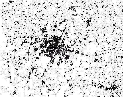
2 TerraSAR-X data Python and ArcGIS for landscape partition FRAGSTATS for spatial pattern analysis Analysis of data and classified map Figure 1: The procedure of task Study area and land cover data set: As study areas, two test sites were chosen, Munich which contains the city of Munich and its suburbs, and Emden which comprises the cities of Emden, Oldenburg, Wilhelmshaven, Aurich and Groningen (located in the Netherland) and also settlements around these cities. As it is clear from the figures below (Figure (2) & Figure (3)), the settlement patterns in the Munich and Emden have noticeable differences in terms of heterogeneity of populated areas. In Munich urban growth is concentrated in center, then settlements distribute as radial in suburb, while in Emden these dense patterns propagate in whole area in more homological situation, as the area of dense settlement patterns in Emden are not as large as agglomerated urban patterns in Munich. 2

3 Source: worldatlasbook.com Figure 2: Location of test site Munich in state of Bavaria and GUF (Global Urban Footprint layer) data with the resolution of 20m 3

4 Source: worldatlasbook.com Figure 3: Location of test site Emden in state of Lower Saxony and GUF (Global Urban Footprint layer) data with the resolution of 20m 4
5 Methodology: 1. Landscape Partition The methodology of this study is landscape partition, as landscape was subdivided in several sublandscapes in order to handle data more efficiently. As type of settlements differ entirely in the limited area. Therefore each test site was converted into square tiles to square tiles which are equal in terms of size and area in Munich and Emden. The landscape partition was done by ArcGIS and Python script programming language, it was started by making clip raster by the size of 900 pixels or meter (pixel size: 20m). In the following of this process, by tiles with 9000, 4500 and 2250 meters in row and column, however because of this way some parts of test sites must be left and will not be used for final results and analysis. 2. Choosing Geospatial Software for Analysis A wide range of geospatial software is available commercially, as freeware and as open source. Here we chose freely available software for this investigation, which is free in license and useful for landscape metrics and spatial analyst goals, additionally it is suitable for the data type in this study (raster data). FRAGSTATS is a computer software program designed to compute a wide variety of landscape metrics for categorical map patterns. Also in the recent years it was developed for variety types of Geographical data. FRAGSTATS is a public-domain GIS implementation of a set of spatial statistics that addresses a fundamental problem in GIS applications and it is a spatial pattern analysis program for categorical maps. FRAGSTATS computes three groups of metrics: Patch metrics, Class metrics and Landscape metrics. Patch metrics are computed for every patch (definition of patch: Surface area that differs from its surroundings in nature or appearance) in the landscape; the output file contains a row (observation vector) for every patch (defined as environmental units), where the columns (fields) represent the single metrics. Class metrics measure the aggregate properties of the patches belonging to a single class or patch type. Landscape metrics are computed for entire patch mosaic; the resulting landscape output file contains a single row (observation vector) for the landscape, where the columns (fields) represent the individual metrics. 5
6 3. Analysis of Landscape Patterns with FRAGSTATS metrics In urban remote sensing or in other words analysis of settlement patterns, a few special metrics of FRAGSTATS will be used. For Patch metrics, metrics such as Patch Area (AREA), Perimeter (PERIM), Radius of Gyration (GYRATE) could be suitable for this study, as Radius of Gyration (GYRATE) is a measure of patch extent, so this metrics displays the bigness of patches. It is clear that every landscape includes of several patches which the largest one is the sign of the most dense area in this task. In Class metrics, metrics like Total (Class) Area (CA), Percentage of Landscape (PLAND), Largest Patch Index (LPI), Total Edge (TE), Edge Density (ED), Number of Patches (NP), Patch Density (PD), Landscape Shape Index (LSI) and Euclidean Nearest-Neighbor Distance (ENN) are practical for analysis of residential area in this task. Percentage of Landscape (PLAND) and Class Area (CA) give information about the area of settlements. Number of Patches (NP) and Patch Density (PD) focus on the subdivision of aggregation, so NP and PD are considerable for number and density of settlements, whereas the sizes of patches (area of settlements) do not have equal bigness, they are not so practical for settlement pattern analysis through the large areas (not in equal tiles), but approximately an idea could be given in a limited area. The Largest Patch Index (LPI) gives information about the type and existence of a spatially dominant urban core. FRAGSTATS computes several statistics representing the amount of perimeter (or edge) at the patch, class, and landscape levels. Edge metrics usually are best considered as representing landscape configuration. At the patch level, edge is a function of patch perimeter (PERIM). At the class and landscape levels, total edge (TE) is an absolute measure of total edge length of a particular patch type or of all patch types. The edge density determines landscape configuration, with large values displaying a more organic, convoluted urban pattern. The nearest neighbor standard deviation valuates uniform or regular distribution of patches against a more irregular or uneven distribution in a landscape. Clearly low values of ENN reveals the dense settlement patterns, however FRAGSTATS metrics for ENN calculates the average amount, such as ENN- MN or ENN-SD. In the table below (Table (1)) some special metrics of FRAGSTATS which were used in this task are explained by formulas. 6
7 Table 1. Spatial metrics used in this study Subject Metric Formula Units Range 1 Patch Area (AREA) AREA = a ij ( 10, 000 ) hectares Area > 0, Patch metrics Perimeter (PERIM) PERIM = P ij meters PERIM > 0, Radius of gyration (GYRATE) GYRATE = h ijr z z r=1 meters GYRATE 0 Class metrics Class Area (CA) Percentage of Landscape (PLAND) Largest Patch Index (LPI) Total Edge (TE) Edge Density (ED) Number of Patches (NP) Patch Density (PD) Landscape Shape Index (LSI) Euclidean Nearest- Neighbor Distance (ENN) n 1 CA = a ij ( 10, 000 ) j=1 PLAND = P i = n j=1 a ij A hectares CA > 0, (100) percent 0<PLAND 100 LPI = max j=1 n (a ij ) (100) percent 0<LPI 100 A ED = m TE = e ik k=1 m k=1 e ik A (10, 000) meters meters per hectare TE > 0, ED > 0, NP=n_i none NP > 1, PD = n i (10, 000)(100) A LSI =. 25 e ik m k=1 A number per 100 hectares PD > 0, constrained by cell size none LSI > 1, ENN = h ij meters ENN> 0, 7
8 4. Final Result based on interpolation As it was explained before, in our study we divided the landscape to equal tiles in four steps. Therefore this master thesis must demonstrate that, partition will describe urbanization and structure of settlement patterns in an effective way. The figure (figure (4)) below reveals the interpolation for different size of tiles and how these partitions increase the accuracy of task. As it is clear, in the final step of partition with smaller tiles, we face with better results. In addition based on the goal of the classification in terms of settlement types, the suitable metrics could be chosen. Here because of type of data and classification which reveals density, was PLAND (percentage of landscape), clearly according to the purpose of study could be applied on other metrics. However the same result could be reached with LPI or NP/CA almost, as larger values for LPI reveal the dense area and vice versa less values of NP/CA display the dense settlements. Classification is done for three types of settlement patterns and contains the adjustment based on urban systems and structures. Nevertheless if interpolation could be applied for Global data, it would be better to use unique classification ranges. 5. Conclusion and future study Overall, Remote Sensing and GIS are useful tools for analysis of large scale settlement patterns, as the capability for landscape classification is one of the most important applications of Remote Sensing. Figure below (figure (4)) reveals how the methodology of partition could be useful to reach thigh accuracy with smaller tiles (not so tiny based on the resolution) and more steps of division. Another thing for high accuracy is the structural pattern of the settlements in terms of distribution, agglomeration and shape of build-up lands, which affects the classification of settlement patterns. As a future study for this task, it is useful to implement and develop a Cellular Automata (CA) Algorithm for urban patterns. Another option for future research could be the comparison of different resolutions of Terra-SAR data to reach classification with better accuracy. Test site: Munich 8
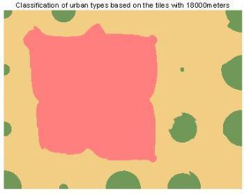
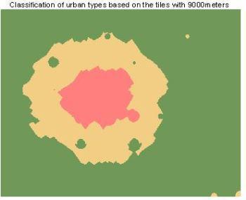
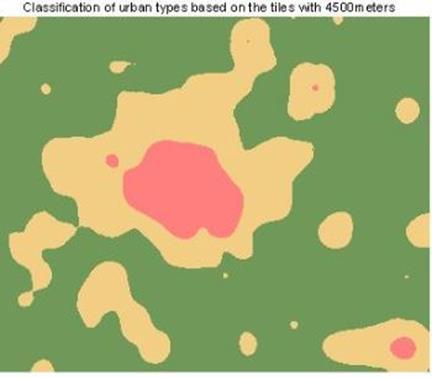
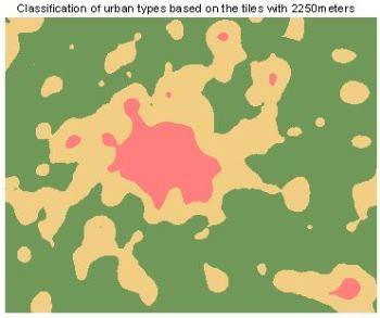
9 REFERENCES Figure 4: Classification of settlement types in Munich 9
10 McGarigal, K., SA Cushman, and E Ene., (2012), FRAGSTATS v4: Spatial Pattern Analysis Program for Categorical and Continuous Maps. Computer software program produced by the authors at the University of Massachusetts, Amherst. Available at the following web site: (last access: 11/10/2013). McGarigal, K., (2012), Fragstats.help.4.pdf. Available at the following web site: stupariu_i_g/docs/2013/noi/25_15_29_40fragstats.help.4.pdf (last access: 13/09/ 2013). Esch, T., Taubenböck, H., Roth, A., Heldens, W., Felbier, A., Thiel, M., Schmidt M, Müller, A., Dech, S., (2012), TanDEM-X mission new perspectives for the inventory and monitoring of global settlement patterns. In: Journal of Applied Remote Sensing. 6(1): 1-21, doi: /1.JRS Esch, T., (2010), Delineation of urban footprints from TerraSAR-X data by analyzing speckle characteristics and intensity information. In: IEEE TRANSACTIONS ON GEOSCIENCE AND REMOTE SENSIN. 48(2): Taubenböck, H., Wegman, M., Wurm, M., Ullmann,T., Dech, S., (2010), The global trend of urbanization-spatiotemporal analysis of mega cities using multi-temporal remote sensing, landscape metrics and gradient analysis. In: Proceeding of the conference SPIE Europe Remote Sensing, Earth Resources and Environmental Remote Sensing/GIS Applications, Toulouse, France, 20. September, edited by Michel, U., Civco, D.L., 7831:78310I 1-20, doi: /
Analysis of urban sprawl phenomenon
 Analysis of urban sprawl phenomenon Detection of city growth based on spatiotemporal analysis and landscape metrics. Leopold Leśko University for Sustainable Development Eberswalde, 2013 Presentanion Outline
LAB EXERCISE #2 Quantifying Patch Mosaics
 LAB EXERCISE #2 Quantifying Patch Mosaics Instructors: K. McGarigal Overview: In this exercise, you will learn to appreciate the challenges of quantifying patch mosaics and gain practical hands-on experience
Spatial metrics for Greek cities using land cover information from the Urban Atlas
 Spatial metrics for Greek cities using land cover information from the Urban Atlas Poulicos Prastacos IACM-FORTH P.O. Box 1385 Heraklion, Greece poulicos@iacm.forth.gr Nektarios Chrysoulakis IACM-FORTH
IndiFrag v2.1: An Object-based Fragmentation Analysis Software Tool. Geo-Environmental Cartography and Remote Sensing Group
 IndiFrag v2.1: An Object-based Fragmentation Analysis Software Tool Geo-Environmental Cartography and Remote Sensing Group http://cgat.webs.upv.es/software/ Universitat Politècnica de València The following
Urban Mapping & Change Detection. Sebastian van der Linden Humboldt-Universität zu Berlin, Germany
 Urban Mapping & Change Detection Sebastian van der Linden Humboldt-Universität zu Berlin, Germany Introduction - The urban millennium Source: United Nations Introduction Text Source: Google Earth Introduction
Urban Process and Future Development of Colombo Metropolitan Area, Sri Lanka: An Application of Geospatial Techniques
 Urban Process and Future Development of Colombo Metropolitan Area, Sri Lanka: An Application of Geospatial Techniques January 2017 Suwandaralalage Indika Shyamantha SUBASINGHE Urban Process and Future
THE SPATIOTEMPORAL LAND USE/COVER CHANGE of ADANA CITY
 THE SPATIOTEMPORAL LAND USE/COVER CHANGE of ADANA CITY A. Akın a, M. A. Erdoğan b, S. Berberoğlu c a Bursa Technical University, Urban and Regional Planning Department, Bursa - anil.tanriover@btu.edu.tr
Remote Sensing Application in Monitoring Impact of Mining Activities on Urban Growth. Case of Makrana Marble Mines, India
 Centre for Research on Settlements and Urbanism Journal of Settlements and Spatial Planning J o u r n a l h o m e p a g e: http://jssp.reviste.ubbcluj.ro Remote Sensing Application in Monitoring Impact
Landscape analysis of urban growth patterns in Seremban, Malaysia, using spatio-temporal data
 IOP Conference Series: Earth and Environmental Science PAPER OPEN ACCESS Landscape analysis of urban growth patterns in Seremban, Malaysia, using spatio-temporal data To cite this article: Maher M Aburas
MAPPING AND ANALYSIS OF FRAGMENTATION IN SOUTHEASTERN NEW HAMPSHIRE
 MAPPING AND ANALYSIS OF FRAGMENTATION IN SOUTHEASTERN NEW HAMPSHIRE Meghan Graham MacLean, PhD Student Dr. Russell G. Congalton, Professor Department of Natural Resources & the Environment, University
URBAN PATTERN ANALYSIS -MAJOR CITIES IN INDIA.
 URBA PATTER AALYSIS -MAJOR CITIES I IDIA. Sowmyashree. M.V 1,3, T.V. Ramachandra 1,2,3. 1 Centre for Ecological Science. 2 Centre for Sustainable Technology. 3 Centre for infrastructure, Sustainable Transportation
Urban Growth Analysis: Calculating Metrics to Quantify Urban Sprawl
 Urban Growth Analysis: Calculating Metrics to Quantify Urban Sprawl Jason Parent jason.parent@uconn.edu Academic Assistant GIS Analyst Daniel Civco Professor of Geomatics Center for Land Use Education
Spatial Process VS. Non-spatial Process. Landscape Process
 Spatial Process VS. Non-spatial Process A process is non-spatial if it is NOT a function of spatial pattern = A process is spatial if it is a function of spatial pattern Landscape Process If there is no
Road-based Landscape Metrics for Quantifying Habitat Fragmentation
 University of South Florida Scholar Commons Graduate Theses and Dissertations Graduate School 2011 Road-based Landscape Metrics for Quantifying Habitat Fragmentation Rebecca Whitehead Loraamm University
Investigation of the Effect of Transportation Network on Urban Growth by Using Satellite Images and Geographic Information Systems
 Presented at the FIG Congress 2018, May 6-11, 2018 in Istanbul, Turkey Investigation of the Effect of Transportation Network on Urban Growth by Using Satellite Images and Geographic Information Systems
INTERNATIONAL JOURNAL OF GEOMATICS AND GEOSCIENCES Volume 7, No 1, 2016
 INTERNATIONAL JOURNAL OF GEOMATICS AND GEOSCIENCES Volume 7, No 1, 2016 Copyright by the authors - Licensee IPA- Under Creative Commons license 3.0 Research article ISSN 0976 4380 Urban sprawl and urban
A Comprehensive Inventory of the Number of Modified Stream Channels in the State of Minnesota. Data, Information and Knowledge Management.
 A Comprehensive Inventory of the Number of Modified Stream Channels in the State of Minnesota Data, Information and Knowledge Management Glenn Skuta Environmental Analysis and Outcomes Division Minnesota
Display data in a map-like format so that geographic patterns and interrelationships are visible
 Vilmaliz Rodríguez Guzmán M.S. Student, Department of Geology University of Puerto Rico at Mayagüez Remote Sensing and Geographic Information Systems (GIS) Reference: James B. Campbell. Introduction to
IndiFrag v2.1: An Object-based Fragmentation Analysis Software Tool
 IndiFrag v2.1: An Object-based Fragmentation Analysis Software Tool Geo-Environmental Cartography and Remote Sensing Group http://cgat.webs.upv.es/software/ Universitat Politècnica de València Introduction
A Constrained CA Model to Simulate Urban Growth of the Tokyo Metropolitan Area
 A Constrained CA Model to Simulate Urban Growth of the Tokyo Metropolitan Area Yaolong Zhao 1, 2, Yuji Murayama 2 1 Faculty of Land Resource Engineering, Kunming University of Science and Technology, Kunming,
Globally Estimating the Population Characteristics of Small Geographic Areas. Tom Fitzwater
 Globally Estimating the Population Characteristics of Small Geographic Areas Tom Fitzwater U.S. Census Bureau Population Division What we know 2 Where do people live? Difficult to measure and quantify.
USING HYPERSPECTRAL IMAGERY
 USING HYPERSPECTRAL IMAGERY AND LIDAR DATA TO DETECT PLANT INVASIONS 2016 ESRI CANADA SCHOLARSHIP APPLICATION CURTIS CHANCE M.SC. CANDIDATE FACULTY OF FORESTRY UNIVERSITY OF BRITISH COLUMBIA CURTIS.CHANCE@ALUMNI.UBC.CA
Analysis of European Topographic Maps for Monitoring Settlement Development
 Analysis of European Topographic Maps for Monitoring Settlement Development Ulrike Schinke*, Hendrik Herold*, Gotthard Meinel*, Nikolas Prechtel** * Leibniz Institute of Ecological Urban and Regional Development,
SENSITIVITY ANALYSIS OF A GIS-BASED CELLULAR AUTOMATA MODEL
 SENSITIVITY ANALYSIS OF A GIS-BASED CELLULAR AUTOMATA MODEL V. Kocabas a, *, S. Dragicevic a a Simon Fraser University, Department of Geography, Spatial Analysis Modeling Laboratory 8888 University Dr.,
Spatio-temporal dynamics in California s Central Valley: Empirical links to urban theory
 International Journal of Geographical Information Science Vol. 19, No. 2, February 2005, 175 195 Spatio-temporal dynamics in California s Central Valley: Empirical links to urban theory CHARLES DIETZEL*,
A METHOD FOR PREDICTING NETWORK DISTANCE USING NETWORK SHORTEST DISTANCE AND SPATIAL INTERPOLATION
 A METHOD FOR PREDICTING NETWORK DISTANCE USING NETWORK SHORTEST DISTANCE AND SPATIAL INTERPOLATION Abdulnaser Arafat Ph.D. Student Urban and Regional Planning Supervisors: Professor Ruth Steiner Professor
SPATIAL STRUCTURE OF LAND USE DYNAMICS IN KATHMANDU VALLEY
 SPATIAL STRUCTURE OF LAND USE DYNAMICS IN KATHMANDU VALLEY Rajesh Bahadur Thapa, Yuji Murayama Division of Spatial Information Science, University of Tsukuba 1-1-1 Tennodai, Tsukuba City, Ibaraki 305-8572,
Effects of thematic resolution on landscape pattern analysis
 Landscape Ecol (7) :7 DOI.7/s8---5 REPORT Effects of thematic resolution on landscape pattern analysis Alexander Buyantuyev Æ Jianguo Wu Received: 5 March / Accepted: April / Published online: 5 August
Development of statewide 30 meter winter sage grouse habitat models for Utah
 Development of statewide 30 meter winter sage grouse habitat models for Utah Ben Crabb, Remote Sensing and Geographic Information System Laboratory, Department of Wildland Resources, Utah State University
Urban structure types as a fingerprints of past, present and future city development
 Urban structure types as a fingerprints of past, present and future city development Jaros law Jasiewicz and Adam D abrowski Institute of Geoecology and Geoinformation, Adam Mickiewicz University in Poznań,
What is a compact city? How could it be measured?
 What is a compact city? How could it be measured? Madhu Singh Transport Planner Directorate of Urban Land Transport, Bangalore Guided By: Professor H. M. Shivanand Swamy CEPT University, Ahmedabad Cities
MODELLING AND UNDERSTANDING MULTI-TEMPORAL LAND USE CHANGES
 MODELLING AND UNDERSTANDING MULTI-TEMPORAL LAND USE CHANGES Jianquan Cheng Department of Environmental & Geographical Sciences, Manchester Metropolitan University, John Dalton Building, Chester Street,
BRIDGING REMOTE SENSING ANALYSTS AND DECISION-MAKERS; THE SUPPORT OF AGGREGATE-MOSAIC THEORY TO MONITOR TROPICAL DEFORESTATION
 BRIDGING REMOTE SENSING ANALYSTS AND DECISION-MAKERS; THE SUPPORT OF AGGREGATE-MOSAIC THEORY TO MONITOR TROPICAL DEFORESTATION M.H. Obbink a,, M. Molenaar b, J.G.P.W. Clevers a, M. Loos a, A. de Gier b
Quantifying the changes in landscape configuration using open source GIS. Case study: Bistrita subcarpathian valley
 From the SelectedWorks of Florin C MIHAI Summer June, 2014 Quantifying the changes in landscape configuration using open source GIS. Case study: Bistrita subcarpathian valley Dan A CHELARU Ana M OISTE
Spatio-temporal dynamics of the urban fringe landscapes
 Spatio-temporal dynamics of the urban fringe landscapes Yulia Grinblat 1, 2 1 The Porter School of Environmental Studies, Tel Aviv University 2 Department of Geography and Human Environment, Tel Aviv University
Swedish examples on , and
 Swedish examples on 11.2.1, 11.3.1 and 11.7.1 Marie Haldorson, Director Seminar in Nairobi 7 Dec 2018 SDG Indicator Tests by Countries in Europe GEOSTAT 3: ESS Project with a purpose to guide countries
1. Introduction. Chaithanya, V.V. 1, Binoy, B.V. 2, Vinod, T.R. 2. Publication Date: 8 April DOI: https://doi.org/ /cloud.ijarsg.
 Cloud Publications International Journal of Advanced Remote Sensing and GIS 2017, Volume 6, Issue 1, pp. 2088-2096 ISSN 2320 0243, Crossref: 10.23953/cloud.ijarsg.112 Research Article Open Access Estimation
DP Project Development Pvt. Ltd.
 Dear Sir/Madam, Greetings!!! Thanks for contacting DP Project Development for your training requirement. DP Project Development is leading professional training provider in GIS technologies and GIS application
SPATIAL CHANGE ANALISYS BASED ON NDVI VALUES USING LANDSAT DATA: CASE STUDY IN TETOVO, MACEDONIA
 Physical Geography; Cartography; Geographic Information Systems & Spatial Planing SPATIAL CHANGE ANALISYS BASED ON NDVI VALUES USING LANDSAT DATA: CASE STUDY IN TETOVO, MACEDONIA DOI: http://dx.doi.org/10.18509/gbp.2016.11
Abiel Yohannes College of Arts and Social Sciences Department of Geography. Advisor: Prof. Zemenfes Tsighe
 Name: Abiel Yohannes College of Arts and Social Sciences Department of Geography Advisor: Prof. Zemenfes Tsighe ANALYSIS OF URBAN SPRAWL AND MODELING USING GEOSPATIAL TOOLS IN NU ES ZOBA KEREN, ERITREA
Analysis of Land cover changes in Dzongu, Sikkim
 Saori Ogura MLA-EP LA221 Final Paper May 12 th 2014 Analysis of Land cover changes in Dzongu, Sikkim Identify how land cover has changed in accordance with social changes I. Problem Statement Sikkim is
Understanding and Measuring Urban Expansion
 VOLUME 1: AREAS AND DENSITIES 21 CHAPTER 3 Understanding and Measuring Urban Expansion THE CLASSIFICATION OF SATELLITE IMAGERY The maps of the urban extent of cities in the global sample were created using
Multifunctional theory in agricultural land use planning case study
 Multifunctional theory in agricultural land use planning case study Introduction István Ferencsik (PhD) VÁTI Research Department, iferencsik@vati.hu By the end of 20 th century demands and expectations
COMMON GIS TECHNIQUES FOR VECTOR AND RASTER DATA PROCESSING. Ophelia Wang, Department of Geography and the Environment, University of Texas
 COMMON GIS TECHNIQUES FOR VECTOR AND RASTER DATA PROCESSING Ophelia Wang, Department of Geography and the Environment, University of Texas PART I: BASIC VECTOR TOOLS CLIP A FEATURE BASED ON THE EXTENT
CUYAHOGA COUNTY URBAN TREE CANOPY & LAND COVER MAPPING
 CUYAHOGA COUNTY URBAN TREE CANOPY & LAND COVER MAPPING FINAL REPORT M IKE GALVIN S AVATREE D IRECTOR, CONSULTING GROUP P HONE: 914 403 8959 E MAIL: MGALVIN@SAVATREE. COM J ARLATH O NEIL DUNNE U NIVERSITY
![)UDQFR54XHQWLQ(DQG'tD]'HOJDGR&](/thumbs/95/125846872.jpg ")UDQFR54XHQWLQ(DQG'tD]'HOJDGR&") &21&(37,21$1',03/(0(17$7,212)$1+
&21&(37,21$1',03/(0(17$7,212)$1+ Time Series Analysis with SAR & Optical Satellite Data
 Time Series Analysis with SAR & Optical Satellite Data Thomas Bahr ESRI European User Conference Thursday October 2015 harris.com Motivation Changes in land surface characteristics mirror a multitude of
GIS APPLICATIONS IN SOIL SURVEY UPDATES
 GIS APPLICATIONS IN SOIL SURVEY UPDATES ABSTRACT Recent computer hardware and GIS software developments provide new methods that can be used to update existing digital soil surveys. Multi-perspective visualization
A Logistic Regression Method for Urban growth modeling Case Study: Sanandaj City in IRAN
 A Logistic Regression Method for Urban growth modeling Case Study: Sanandaj City in IRAN Sassan Mohammady GIS MSc student, Dept. of Surveying and Geomatics Eng., College of Eng. University of Tehran, Tehran,
Using Geographic Information Systems and Remote Sensing Technology to Analyze Land Use Change in Harbin, China from 2005 to 2015
 Using Geographic Information Systems and Remote Sensing Technology to Analyze Land Use Change in Harbin, China from 2005 to 2015 Yi Zhu Department of Resource Analysis, Saint Mary s University of Minnesota,
Volume 5, Issue 10, October 2017 International Journal of Advance Research in Computer Science and Management Studies I. INTRODUCTION II.
 ISSN: 2321-7782 (Online) e-isjn: A4372-3114 Impact Factor: 6.047 Volume 5, Issue 10, October 2017 International Journal of Advance Research in Computer Science and Management Studies Research Article /
Urban Area Delineation Using Pattern Recognition Technique
 Cloud Publications International Journal of Advanced Remote Sensing and GIS 2018, Volume 7, Issue 1, pp. 2466-2470 ISSN 2320 0243, Crossref: 10.23953/cloud.ijarsg.333 Methodology Article Urban Area Delineation
Diversity of Settlement Categories in Very High Resolution SAR Images
 Diversity of Settlement Categories in Very High Resolution SAR Images Corneliu Octavian Dumitru Remote Sensing Technology Institute (IMF) German Aerospace Center (DLR) Oberpfaffenhofen Wessling, Germany
Land Use/Cover Change Detection Using Feature Database Based on Vector-Image Data Conflation
 Proceedings of the 8th International Symposium on Spatial Accuracy Assessment in Natural Resources and Environmental Sciences Shanghai, P. R. China, June 25-27, 2008, pp. 255-262 Land Use/Cover Change
Contents Introduction... 3 Get the data... 4 Workflow... 7 Test 1: Urban fabric (all)... 8 Test 2: Urban fabric (industrial and commercial)...
... 8 Test 2: Urban fabric (industrial and commercial)...") AAXY tutorial Contents Introduction... 3 Get the data... 4 Workflow... 7 Test 1: Urban fabric (all)... 8 Test 2: Urban fabric (industrial and commercial)... 9 Test 3: Urban fabric (residential)... 10 Test
AAXY tutorial Contents Introduction... 3 Get the data... 4 Workflow... 7 Test 1: Urban fabric (all)... 8 Test 2: Urban fabric (industrial and commercial)... 9 Test 3: Urban fabric (residential)... 10 Test
Remote Sensing for Seismic Vulnerability Assessment of Built Environments
 www.dlr.de Folie 1/20 Remote Sensing for Seismic Vulnerability Assessment of Built Environments Christian Geiß, Joachim Post, Hannes Taubenböck et al. www.dlr.de Folie 2/20 Motivation - Rapid urbanization
Simulation of Wetlands Evolution Based on Markov-CA Model
 Simulation of Wetlands Evolution Based on Markov-CA Model ZHANG RONGQUN 1 ZHAI HUIQING 1 TANG CHENGJIE 2 MA SUHUA 2 1 Department of Geography informantion science, College of information and Electrical
Earth Observation & GeoSpatial Information for Monitoring Urban SDG Indicators. Global Urbanization Trend
 Earth Observation & GeoSpatial Information for Monitoring Urban SDG Indicators Yifang Ban, Professor Director, Division of Geoinformatics Vice Chair, Department for Urban Planning and Environment KTH Royal
Creating Watersheds from a DEM
 Creating Watersheds from a DEM These instructions enable you to create watersheds of specified area using a good quality Digital Elevation Model (DEM) in ArcGIS 8.1. The modeling is performed in ArcMap
Tutorial 8 Raster Data Analysis
 Objectives Tutorial 8 Raster Data Analysis This tutorial is designed to introduce you to a basic set of raster-based analyses including: 1. Displaying Digital Elevation Model (DEM) 2. Slope calculations
Current Landscape 1 Percentiles of Simulated Distribution HRV. Departure Index 3. Metric. Percentile of HRV CV 2
 Table. Range of variation in landscape structure for Pure Aspen Forest under the simulated HRV disturbance scenario on the SE Quadrant, Uncompahgre Plateau Landscape, Colorado, and the degree of departure
Massachusetts Institute of Technology Department of Urban Studies and Planning
 Massachusetts Institute of Technology Department of Urban Studies and Planning 11.520: A Workshop on Geographic Information Systems 11.188: Urban Planning and Social Science Laboratory GIS Principles &
Introduction. Project Summary In 2014 multiple local Otsego county agencies, Otsego County Soil and Water
 Introduction Project Summary In 2014 multiple local Otsego county agencies, Otsego County Soil and Water Conservation District (SWCD), the Otsego County Planning Department (OPD), and the Otsego County
Mapping Landscape Change: Space Time Dynamics and Historical Periods.
 Mapping Landscape Change: Space Time Dynamics and Historical Periods. Bess Moylan, Masters Candidate, University of Sydney, School of Geosciences and Archaeological Computing Laboratory e-mail address:
URBAN GROWTH SIMULATION: A CASE STUDY
 URBAN GROWTH SIMULATION: A CASE STUDY V. Swathi 1, S. Sai Veena 2, K. Srinivasa Raju 3 1 Research Scholar, 2 Under Graduate Student, 3 Professor * Corresponding Author; Email: p201244029@hyderabad.bits-pilani.ac.in.
The polygon overlay problem in electoral geography
 The polygon overlay problem in electoral geography Romain Louvet *1,2, Jagannath Aryal 2, Didier Josselin 1,3, Christèle Marchand-Lagier 4, Cyrille Genre-Grandpierre 1 1 UMR ESPACE 7300 CNRS, Université
APPLICATION OF LAND CHANGE MODELER FOR PREDICTION OF FUTURE LAND USE LAND COVER A CASE STUDY OF VIJAYAWADA CITY
 APPLICATION OF LAND CHANGE MODELER FOR PREDICTION OF FUTURE LAND USE LAND COVER A CASE STUDY OF VIJAYAWADA CITY K. Sundara Kumar 1, Dr. P. Udaya Bhaskar 2, Dr. K. Padmakumari 3 1 Research Scholar, 2,3
Urban Mapping. Sebastian van der Linden, Akpona Okujeni, Franz Schug 11/09/2018
 Urban Mapping Sebastian van der Linden, Akpona Okujeni, Franz Schug 11/09/2018 Introduction to urban remote sensing Introduction The urban millennium Source: United Nations, 2014 Urban areas mark extremes
Rio Santa Geodatabase Project
 Rio Santa Geodatabase Project Amanda Cuellar December 7, 2012 Introduction The McKinney research group (of which I am a part) collaborates with international and onsite researchers to evaluate the risks
RADAR BACKSCATTER AND COHERENCE INFORMATION SUPPORTING HIGH QUALITY URBAN MAPPING
 RADAR BACKSCATTER AND COHERENCE INFORMATION SUPPORTING HIGH QUALITY URBAN MAPPING Peter Fischer (1), Zbigniew Perski ( 2), Stefan Wannemacher (1) (1)University of Applied Sciences Trier, Informatics Department,
International Journal of Intellectual Advancements and Research in Engineering Computations
 ISSN:2348-2079 Volume-5 Issue-2 International Journal of Intellectual Advancements and Research in Engineering Computations Agricultural land investigation and change detection in Coimbatore district by
Measuring Urban Sprawl A Case Study of China
 Institute for Regional Development Planning, University of Stuttgart Applying Remote Sensing and GIS on Monitoring and Measuring Urban Sprawl A Case Study of China Outline Research hbackground and dobjectives
URBANIZATION is one of the most pressing global challenges.
 IEEE GEOSCIENCE AND REMOTE SENSING LETTERS, VOL. 10, NO. 6, NOVEMBER 2013 1617 Urban Footprint Processor Fully Automated Processing Chain Generating Settlement Masks From Global Data of the TanDEM-X Mission
RESEARCH METHODOLOGY
 III. RESEARCH METHODOLOGY 3.1. Time and Research Area The field work was taken place in primary forest around Toro village in Lore Lindu National Park, Indonesia. The study area located in 120 o 2 53 120
Evaluating Urban Vegetation Cover Using LiDAR and High Resolution Imagery
 Evaluating Urban Vegetation Cover Using LiDAR and High Resolution Imagery Y.A. Ayad and D. C. Mendez Clarion University of Pennsylvania Abstract One of the key planning factors in urban and built up environments
Combing Open-Source Programming Languages with GIS for Spatial Data Science. Maja Kalinic Master s Thesis
 Combing Open-Source Programming Languages with GIS for Spatial Data Science Maja Kalinic Master s Thesis International Master of Science in Cartography 14.09.2017 Outline Introduction and Motivation Research
Calculating Land Values by Using Advanced Statistical Approaches in Pendik
 Presented at the FIG Congress 2018, May 6-11, 2018 in Istanbul, Turkey Calculating Land Values by Using Advanced Statistical Approaches in Pendik Prof. Dr. Arif Cagdas AYDINOGLU Ress. Asst. Rabia BOVKIR
Abstract. TECHNOFAME- A Journal of Multidisciplinary Advance Research. Vol.2 No. 2, (2013) Received: Feb.2013; Accepted Oct.
 Received: Feb.2013; Accepted Oct.") Vol.2 No. 2, 83-87 (2013) Received: Feb.2013; Accepted Oct. 2013 Landuse Pattern Analysis Using Remote Sensing: A Case Study of Morar Block, of Gwalior District, M.P. Subhash Thakur 1 Akhilesh Singh 2
Vol.2 No. 2, 83-87 (2013) Received: Feb.2013; Accepted Oct. 2013 Landuse Pattern Analysis Using Remote Sensing: A Case Study of Morar Block, of Gwalior District, M.P. Subhash Thakur 1 Akhilesh Singh 2
Title: Effect on surface deformation resulting from mining activity on value of property valuation : a case study from Jastrzębie-Zdrój region
 Title: Effect on surface deformation resulting from mining activity on value of property valuation : a case study from Jastrzębie-Zdrój region Author: Paweł Pala Citation style: Pala Paweł. (2018). Effect
DROUGHT ASSESSMENT USING SATELLITE DERIVED METEOROLOGICAL PARAMETERS AND NDVI IN POTOHAR REGION
 DROUGHT ASSESSMENT USING SATELLITE DERIVED METEOROLOGICAL PARAMETERS AND NDVI IN POTOHAR REGION Researcher: Saad-ul-Haque Supervisor: Dr. Badar Ghauri Department of RS & GISc Institute of Space Technology
Object Based Image Classification for Mapping Urban Land Cover Pattern; A case study of Enugu Urban, Enugu State, Nigeria.
 Object Based Image Classification for Mapping Urban Land Cover Pattern; A case study of Enugu Urban, Enugu State, Nigeria. Nnam, Godwin Uchechukwu, u_nnam@yahoo.com a Ndukwu, Raphael I., raphael.ndukwu@unn.edu.ng
Geostatistics and Spatial Scales
 Geostatistics and Spatial Scales Semivariance & semi-variograms Scale dependence & independence Ranges of spatial scales Variable dependent Fractal dimension GIS implications Spatial Modeling Spatial Analysis
Introduction to GIS - 2
 Introduction to GIS - 2 Outline Using GIS Representation of spatial objects in GIS Prof. D. Nagesh Kumar Department of Civil Engineering Indian Institute of Science Bangalore 560 012, India http://www.civil.iisc.ernet.in/~nagesh
BGD. Biogeosciences Discussions
 Biogeosciences Discuss., www.biogeosciences-discuss.net/8/c1604/2011/ Author(s) 2011. This work is distributed under the Creative Commons Attribute 3.0 License. Biogeosciences Discussions comment on Analysis
Spatiotemporal Analysis of Noida, Greater Noida and Surrounding Areas (India) Using Remote Sensing and GIS Approaches
 Using Remote Sensing and GIS Approaches") Spatiotemporal Analysis of Noida, Greater Noida and Surrounding Areas (India) Using Remote Sensing and GIS Approaches Gopal Krishna* Indian Agricultural Research Institute, New Delhi, India ABSTRACT Spatiotemporal
Spatiotemporal Analysis of Noida, Greater Noida and Surrounding Areas (India) Using Remote Sensing and GIS Approaches Gopal Krishna* Indian Agricultural Research Institute, New Delhi, India ABSTRACT Spatiotemporal
Spatial analysis. Spatial descriptive analysis. Spatial inferential analysis:
 Spatial analysis Spatial descriptive analysis Point pattern analysis (minimum bounding box, mean center, weighted mean center, standard distance, nearest neighbor analysis) Spatial clustering analysis
Accuracy Assessment of SRTM Data Case Study: New Cairo, Hurghada and Toshka in Egypt
 Australian Journal of Basic and Applied Sciences, 4(12): 6269-6275, 2010 ISSN 1991-8178 Accuracy Assessment of SRTM Data Case Study: New Cairo, Hurghada and Toshka in Egypt 1 Assoc. Prof. Dr. A.K. Abdel-Gawad,
Assessing urban daylight potential and operational energy across different urban typologies
 Assessing urban daylight potential and operational energy across different urban typologies 2ª CONFERÊNCIA ADVANCED SPATIAL MODELING AND ANALYSIS, 7 th July, IGOT/CEG - Lisbon João Fumega IST and IGOT/CEG
Research Article A Landscape Approach for Detecting and Assessing Changes in an Area Prone to Desertification in Sardinia (Italy)
") Navigation and Observation Volume 2008, Article ID 549630, 5 pages doi:10.1155/2008/549630 Research Article A Landscape Approach for Detecting and Assessing Changes in an Area Prone to Desertification
Navigation and Observation Volume 2008, Article ID 549630, 5 pages doi:10.1155/2008/549630 Research Article A Landscape Approach for Detecting and Assessing Changes in an Area Prone to Desertification
Make it Spatial. Josh Tanner. Theresa Burcsu. Tools, techniques, and tips for incorporating GIS into your research
 Make it Spatial Tools, techniques, and tips for incorporating GIS into your research Theresa Burcsu Josh Tanner Oregon GIS Framework Coordinator GIS Analyst & Web Administrator Geospatial Enterprise Office
Preparing the GEOGRAPHY for the 2011 Population Census of South Africa
 Preparing the GEOGRAPHY for the 2011 Population Census of South Africa Sharthi Laldaparsad Statistics South Africa; E-mail: sharthil@statssa.gov.za Abstract: Statistics South Africa (Stats SA) s Geography
USING DOWNSCALED POPULATION IN LOCAL DATA GENERATION
 USING DOWNSCALED POPULATION IN LOCAL DATA GENERATION A COUNTRY-LEVEL EXAMINATION CONTENT Research Context and Approach. This part outlines the background to and methodology of the examination of downscaled
Page 1 of 8 of Pontius and Li
 ESTIMATING THE LAND TRANSITION MATRIX BASED ON ERRONEOUS MAPS Robert Gilmore Pontius r 1 and Xiaoxiao Li 2 1 Clark University, Department of International Development, Community and Environment 2 Purdue
Software for Landuse Management: Modelling with GIS
 O. R. SODEINDE, Nigeria Key words: ABSTRACT Land use management has been a very important issue in the planning and maintenance of environmental and economic development of a geographic area. Therefore,
Chapter 6. Fundamentals of GIS-Based Data Analysis for Decision Support. Table 6.1. Spatial Data Transformations by Geospatial Data Types
 Chapter 6 Fundamentals of GIS-Based Data Analysis for Decision Support FROM: Points Lines Polygons Fields Table 6.1. Spatial Data Transformations by Geospatial Data Types TO: Points Lines Polygons Fields
of a landscape to support biodiversity and ecosystem processes and provide ecosystem services in face of various disturbances.
 L LANDSCAPE ECOLOGY JIANGUO WU Arizona State University Spatial heterogeneity is ubiquitous in all ecological systems, underlining the significance of the pattern process relationship and the scale of
REMOTE SENSING AND GEOSPATIAL APPLICATIONS FOR WATERSHED DELINEATION
 REMOTE SENSING AND GEOSPATIAL APPLICATIONS FOR WATERSHED DELINEATION Gaurav Savant (gaurav@engr.msstate.edu) Research Assistant, Department of Civil Engineering, Lei Wang (lw4@ra.msstate.edu) Research
Urban land cover and land use extraction from Very High Resolution remote sensing imagery
 Urban land cover and land use extraction from Very High Resolution remote sensing imagery Mengmeng Li* 1, Alfred Stein 1, Wietske Bijker 1, Kirsten M.de Beurs 2 1 Faculty of Geo-Information Science and
Analysis of urban changes using geographic information system (GIS): Case Area of Pyin Oo Lwin Township (Myanmar)
: Case Area of Pyin Oo Lwin Township (Myanmar)") 2018; SP1: 676-680 E-ISSN: 2278-4136 P-ISSN: 2349-8234 JPP 2018; SP1: 676-680 Aye Pwint Phyu Hnin Hnin Htun Thett Oo Eain Htet Ne Oo Correspondence Aye Pwint Phyu Analysis of urban changes using geographic
2018; SP1: 676-680 E-ISSN: 2278-4136 P-ISSN: 2349-8234 JPP 2018; SP1: 676-680 Aye Pwint Phyu Hnin Hnin Htun Thett Oo Eain Htet Ne Oo Correspondence Aye Pwint Phyu Analysis of urban changes using geographic
Preparation of LULC map from GE images for GIS based Urban Hydrological Modeling
 International Conference on Modeling Tools for Sustainable Water Resources Management Department of Civil Engineering, Indian Institute of Technology Hyderabad: 28-29 December 2014 Abstract Preparation