M.C.PALIWAL. Department of Civil Engineering NATIONAL INSTITUTE OF TECHNICAL TEACHERS TRAINING & RESEARCH, BHOPAL (M.P.), INDIA
|
|
|
- Polly Lewis
- 6 years ago
- Views:
Transcription
1 INVESTIGATIONS ON THE ACCURACY ASPECTS IN THE LAND USE/LAND COVER MAPPING USING REMOTE SENSING SATELLITE IMAGERY By M.C.PALIWAL Department of Civil Engineering NATIONAL INSTITUTE OF TECHNICAL TEACHERS TRAINING & RESEARCH, BHOPAL (M.P.), INDIA
2 INTRODUCTION: Different methods of land use/land cover Conventional methods Modern methods- RS,GIS,GPS Classification of satellite image Accuracy aspects
3 Need for land use maps: Now a days due to rapid growth in urbanization and industrialization, there is increasing pressure on land, water and environment. Urban sprawl may be found everywhere in major cities. There are many problems related with conversion of agricultural land in to urban use. Every city is expanding in all directions resulting in large-scale changes in urban land use.
4 Land cover and Land use : Land cover is that which covers the surface of the earth and land use describes how the land cover is modified. Land cover includes: water, grassland, forest, bare soil etc. Land use includes agricultural land, recreation area, built up land, etc.
5 The function of Land use maps: To make property maps and to do settlement. To conduct topographic survey for infrastructure development. To keep database records related to property. To evaluate the property value. To divide the property in case of disputes. To work with Board of Revenue, Public works departments, Utility companies etc.
6 Conventional Methods: Chains to measure distances Old mechanical Theodolites Vernier Theodolites Paper maps etc.
7 Disadvantages of using Conventional Method: Chains data can be taken only in perpendicular direction, while actually land/fields is of Zig Zag shape. Chain data is always inaccurate. The land cost of today demands a more accurate method. The maps generated by manual methods can not be reproduced at user required scale. If scale has to be changed then whole map has to be redrawn. Attribute data for a field can not be attached on a paper map. (i.e.the name of the owner, the area, the cost etc. has no relation with the map.) Decision making process using old paper maps becomes very cumbersome and some time it leads to wrong decision.
8 Modern methods: Making a map using Coordinates rather than by Angles and distances. Area computation can be done using Total Stations as well as GPS then and there itself. Using Total Stations and Mapping Software the maps can be created automatically. Map at any scale can be created because of availability of data in electronic format. A full-fledged GIS can be generated so that just be click of a key all the attributes corresponding to a land piece can be obtained.
9 Developments in the Surveying Techniques and advantages of new mapping Techniques: Conventional Survey Methods are very tedious and time consuming. Large Number of measurements are required to prepare a map. Automated Survey Techniques are simpler and easy to record survey measurements. 9
10 AUTOMATED SURVEYING TECHNOLOGY Automatic and Laser level Total Stations Global Positioning Systems (GPS) Photogrammetric Survey Remote Sensing Methods (RS) 10
11 Ground based technique limitations and advantages of satellite based techniques. In Conventional Survey all the field values are to be noted down in the field book and plotting is done manually in the office. In GPS based surveys, the GPS Receiver records the Satellite signal. GPS receiver can be attached to computer and automatically plots the maps.. 11
12 Conventional Survey GPS Survey GPS Survey 12
13 REMOTE SENSING [RS] A-Energy Sources B-Radiation & Atmosphere C-Interaction with target D-Recording of Energy by the sensor E-Transmission, Recording and Processing F-Interpretation and Analysis G-Application Introduction Cont

14 GIS AND ITS COMPONENTS Component
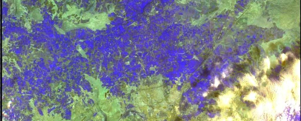
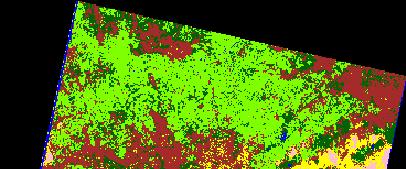
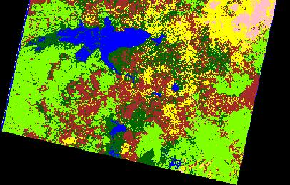
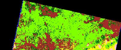
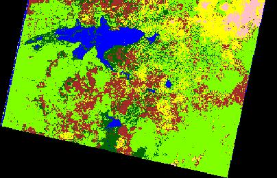
15 IRS-1D LISS-III DATA (23.5 M RESOLUTION) AIR STRIP UPPER LAKE BHEL MANTRALAYA BHOPAL AS SEEN ON 25 th NOV
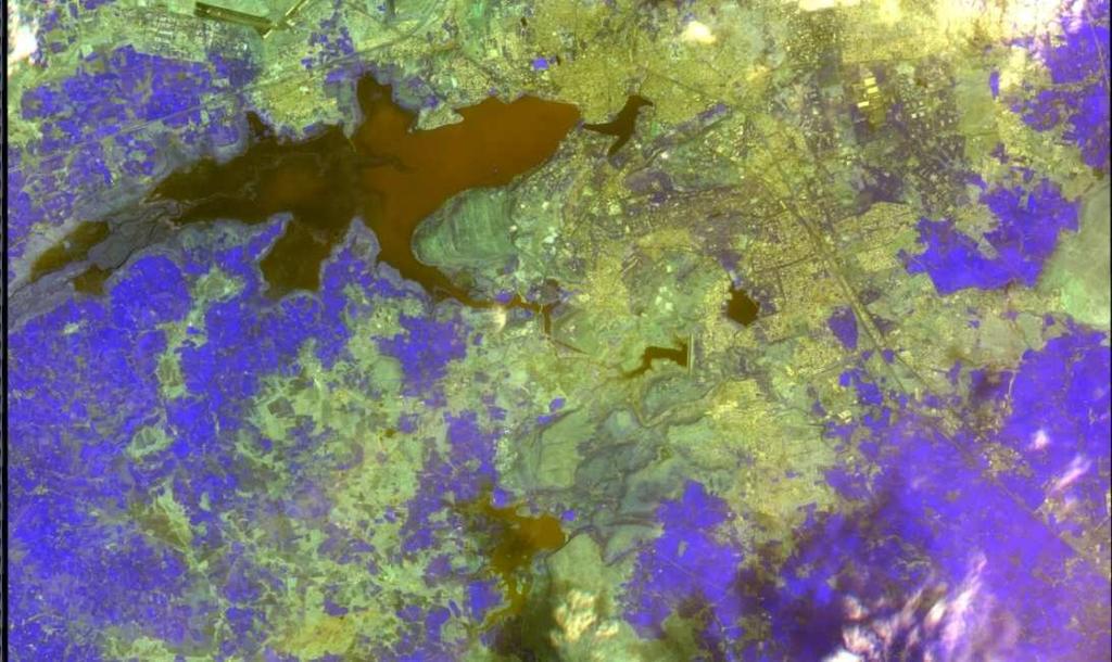
16 IRS-1D PAN & LISS III MERGED DATA (5.8 M RESOLUTION) BHOPAL AS SEEN ON 14th NOV
17 Accuracy aspects in land use/land cover maps: Land cover maps derived from remotely sensed data inevitably contain error of various types and degrees. It is therefore very important that the nature of these errors be determined, to gauge their appropriateness for specific uses. Identifying and correcting the sources of errors may increase the quality of map information. Classification accuracy assessment is necessary for comparing the performance of various classification techniques. 17
18 Today, the error matrix has become the standard medium for reporting the accuracy of maps derived from remotely sensed data (Congalton and Green, 1993). More recent research into classification accuracy assessment has focused on factors influencing the accuracy of spatial data, such as sampling scheme and sample size, classification scheme, and spatial autocorrelation ( Congalton and Green, 1993). Other important considerations in classification accuracy assessment include ground verification techniques, and evaluation of all sources of error in the spatial data set. 18
19 Accuracy aspects : Assessing the accuracy of maps generated from remotely sensed data requires evaluating both positional accuracy and thematic accuracy. While these two accuracies can be assessed separately, they are very much interrelated and failure to consider both of them is a serious mistake.
20 Positional Accuracy: Positional accuracy, a measure of how closely the imagery fits the ground, is the most common measure of map accuracy. In other words, positional accuracy is the accuracy of the location of a point in the imagery with reference to its physical location on the ground.
21 Thematic Accuracy: Thematic accuracy refers to the accuracy of a mapped land cover category at a particular time compared to what was actually on the ground at that time. Clearly, to perform a meaningful assessment of accuracy, land cover classifications must be assessed using data that are believed to be correct.
22 Accuracy aspects : A classification is not complete until its accuracy is assessed. A classification error matrix is prepared based on training data. Error matrix compares the ground truth and the corresponding results of an automated classification. Overall accuracy and individual accuracy is calculated. 22
23 Need of reliable calibration and ground truthing in the map extraction. KAPPA is a technique developed by Cohen (1960) and has been utilized for land cover and land use accuracy assessment derived from remotely sensed data (Congalton et al., 1983; Rosenfield and Fitzpatrick-Lins, 1986; Gong and Howarth, 1990). The result of performing a KAPPA analysis is the KHAT statistic (an estimate of KAPPA) which is another measure of accuracy or agreement. 23
24 Trend in map extraction from imagery using classification and feature extraction. In order to obtain unbiased ground reference information to compare with the remote sensing classification map and fill the error matrix values, we need to determine the most appropriate (i.e., minimum) sample size acceptable for a valid statistical testing of accuracy of the land cover map. In addition, an appropriate sampling scheme must be used to locate the sample points. 24
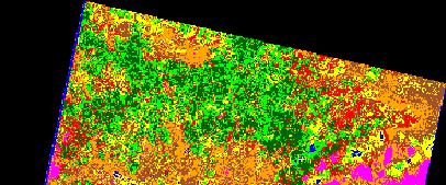
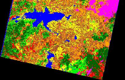
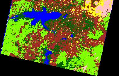
25 METHODOLOGY: Select various feasible land use categories in and around Bhopal city. Classify images by using ERDAS software and selecting different supervised methods as well as unsupervised methods. Verify classification accuracy by ground truthing with the help of GPS as well as Google images. Digitize each class boundary on Google image as well as different classified images and superimpose then in ERDAS to verify accuracy. 25
26 Study area and Data Resources: Bhopal City & adjoining area Some data of LISS-4 were purchased from NRSA Hyderabad for the date of field work done. 26
27
28 After acquiring the satellite images of the study areas, classification of LISS 4 Image of Bhopal was applied to the four methods of classification. These are: Unsupervised classification in which the applied algorithm is Iterative Self-Organizing Data Analysis Technique (ISODATA) Three different supervised methods which include Maximum likelihood, Mahalanobis Distance, and Minimum Distance.
29 After classified thematic maps were developed, accuracy was tested by different methods of accuracy assessment, and the post- classification process was the last process in classification. The software packages used for classification was ERDAS IMAGINE 11.
30 Class No. Name of class 1 Water bodies 2 Agricultural fields 3 Clouds/error 4 Urban buildings 5 Barren land 6 Forest
31
32
33
34
35
36 Image Classifi ication Ground Reference Row Total Colum n Total Maximum Likelihood Method:.Overall Accuracy= (104/130) x100=80% Calculate Producer s Accuracy for each class and User s Accuracy for each class.
37 Class 1=(12/15)x100=80.00% Class 2=(18/24)x100=75.00% Class 3=(12/18)x100=66.67% Class 4=(16/20)x100=80.00% Class 5=(16/21)x100=76.19% Class 6=(30/32)x100=93.75%
38 Class 1=(12/14)x100=85.71% Class 2=(18/22)x100=81.81% Class 3=(12/16)x100=75.00% Class 4=(16/21)x100=76.19% Class 5=(16/21)x100=76.19% Class 6=(30/36)x100=83.33%
39 Image Classifi ication Ground Reference Ro w Tot al Colum n Total Mahalanobis Distance Method:..Overall Accuracy= (107/140) x100=74.28%
40 Image Classifi ication Ground Reference Ro w Tot al Colum n Total Minimum Distance Method:.Overall Accuracy= (87/130) x100=67%
41 Error matrices produced to evaluate the classification methods show that the best overall classification accuracy method was the maximum likelihood with an average accuracy of about 80%. The second best overall classification accuracy method was mahalanobis distance; with an average accuracy of 74% and the worst overall classification accuracy method was minimum distance with an average accuracy of 67%.
42 References: 1.Jay Gao (2008):DETECTION OF CHANGES IN LAND DEGRADATION IN NORTHEAST CHINA FROM LANDSAT TM AND ASTER DATA, The International Archives of the Photogrammetry, Remote Sensing and Spatial Information Sciences. Vol. XXXVII. Part B7. Beijing-pp Prakasam.C.(2010):Land use and land cover change detection through remote sensing approach: A case study of Kodaikanal taluk, Tamil nadu, INTERNATIONAL JOURNAL OF GEOMATICS AND GEOSCIENCES Volume 1, No 2, 2010, 42
43 Contd. Yichun Xie et.al.(2008),remote sensing imagery in vegetation mapping: a review, Journal of Plant Ecology VOLUME 1, NUMBER 1, PAGES 9 23 MARCH 2008 Y.Babykalpana, K.ThanushKodi (2011):CLASSIFICATION OF LAND USE LAND COVER CHANGE DETECTION USING REMOTELY SENSED DATA,International Journal on Computer Science and Engineering (IJCSE) pp S. Balaselvakumar et.al. (2003),Remote Sensing Techniques for Land Use Mapping of Arjuna Basin, Tamil Nadu, Map Asia
44 Claudio Conese and Fabio MaseUi (1992), Use of Error Matrices to Improve Area Estimates with Maximum Likelihood Classification Procedures, REMOTE SENSING AND ENVIRONMENT 40: (1992) Ramachandra, T.V. and Uttam Kumar(2004): Geographic Resources Decision Support System for land use, land cover dynamics analysis, Proceedings of the FOSS/GRASS Users Conference - Bangkok, Thailand, September 2004 Marcus E. Engdahl and Juha M. Hyyppä(2003): Land- Cover Classification Using Multitemporal ERS-1/2 InSAR Data, IEEE TRANSACTIONS ON GEOSCIENCE AND REMOTE SENSING, VOL. 41, NO. 7, JULY
45 contd. M. A. Ibrahim et.al.(2004):approaches to Improve Accuracy of Neural Network Classification of Images Dominated by Mixed Pixels, IEEE,(2004), pp Nancy Thomas, et. al.(2003): A Comparison of Urban Mapping Methods Using High-Resolution Digital Imagery, Photogrammetric Engineering & Remote Sensing Vol. 69, No. 9, September 2003, pp
46 THANK YOU.
International Journal of Scientific & Engineering Research, Volume 6, Issue 7, July ISSN
 International Journal of Scientific & Engineering Research, Volume 6, Issue 7, July-2015 1428 Accuracy Assessment of Land Cover /Land Use Mapping Using Medium Resolution Satellite Imagery Paliwal M.C &.
Abstract: About the Author:
 REMOTE SENSING AND GIS IN LAND USE PLANNING Sathees kumar P 1, Nisha Radhakrishnan 2 1 1 Ph.D Research Scholar, Department of Civil Engineering, National Institute of Technology, Tiruchirappalli- 620015,
INTERNATIONAL JOURNAL OF GEOMATICS AND GEOSCIENCES Volume 2, No 1, 2011
 INTERNATIONAL JOURNAL OF GEOMATICS AND GEOSCIENCES Volume 2, No 1, 2011 Copyright 2010 All rights reserved Integrated Publishing services Research article ISSN 0976 4380 Spatio-Temporal changes of Land
1. Introduction. S.S. Patil 1, Sachidananda 1, U.B. Angadi 2, and D.K. Prabhuraj 3
 Cloud Publications International Journal of Advanced Remote Sensing and GIS 2014, Volume 3, Issue 1, pp. 525-531, Article ID Tech-249 ISSN 2320-0243 Research Article Open Access Machine Learning Technique
Deriving Uncertainty of Area Estimates from Satellite Imagery using Fuzzy Land-cover Classification
 International Journal of Information and Computation Technology. ISSN 0974-2239 Volume 3, Number 10 (2013), pp. 1059-1066 International Research Publications House http://www. irphouse.com /ijict.htm Deriving
Preparation of LULC map from GE images for GIS based Urban Hydrological Modeling
 International Conference on Modeling Tools for Sustainable Water Resources Management Department of Civil Engineering, Indian Institute of Technology Hyderabad: 28-29 December 2014 Abstract Preparation
7.1 INTRODUCTION 7.2 OBJECTIVE
 7 LAND USE AND LAND COVER 7.1 INTRODUCTION The knowledge of land use and land cover is important for many planning and management activities as it is considered as an essential element for modeling and
CHANGES IN VIJAYAWADA CITY BY REMOTE SENSING AND GIS
 International Journal of Civil Engineering and Technology (IJCIET) Volume 8, Issue 5, May 2017, pp.217 223, Article ID: IJCIET_08_05_025 Available online at http://www.ia aeme.com/ijciet/issues.asp?jtype=ijciet&vtyp
APPLICATION OF LAND CHANGE MODELER FOR PREDICTION OF FUTURE LAND USE LAND COVER A CASE STUDY OF VIJAYAWADA CITY
 APPLICATION OF LAND CHANGE MODELER FOR PREDICTION OF FUTURE LAND USE LAND COVER A CASE STUDY OF VIJAYAWADA CITY K. Sundara Kumar 1, Dr. P. Udaya Bhaskar 2, Dr. K. Padmakumari 3 1 Research Scholar, 2,3
Remote Sensing and GIS Application in Change Detection Study Using Multi Temporal Satellite
 Cloud Publications International Journal of Advanced Remote Sensing and GIS 2013, Volume 2, Issue 1, pp. 374-378, Article ID Tech-181 ISSN 2320-0243 Case Study Open Access Remote Sensing and GIS Application
Landuse and Landcover change analysis in Selaiyur village, Tambaram taluk, Chennai
 Landuse and Landcover change analysis in Selaiyur village, Tambaram taluk, Chennai K. Ilayaraja Department of Civil Engineering BIST, Bharath University Selaiyur, Chennai 73 ABSTRACT The synoptic picture
Effect of land use/land cover changes on runoff in a river basin: a case study
 Water Resources Management VI 139 Effect of land use/land cover changes on runoff in a river basin: a case study J. Letha, B. Thulasidharan Nair & B. Amruth Chand College of Engineering, Trivandrum, Kerala,
Vegetation Change Detection of Central part of Nepal using Landsat TM
 Vegetation Change Detection of Central part of Nepal using Landsat TM Kalpana G. Bastakoti Department of Geography, University of Calgary, kalpanagb@gmail.com Abstract This paper presents a study of detecting
UNITED NATIONS E/CONF.96/CRP. 5
 UNITED NATIONS E/CONF.96/CRP. 5 ECONOMIC AND SOCIAL COUNCIL Eighth United Nations Regional Cartographic Conference for the Americas New York, 27 June -1 July 2005 Item 5 of the provisional agenda* COUNTRY
Yanbo Huang and Guy Fipps, P.E. 2. August 25, 2006
 Landsat Satellite Multi-Spectral Image Classification of Land Cover Change for GIS-Based Urbanization Analysis in Irrigation Districts: Evaluation in Low Rio Grande Valley 1 by Yanbo Huang and Guy Fipps,
International Journal of Scientific & Engineering Research, Volume 3, Issue 11, November ISSN
 International Journal of Scientific & Engineering Research, Volume 3, Issue 11, November-2012 1 ABSTRACT Land use land cover change detection of Ghatkesar mandal,rangareddy district using Remote sensing
Geographic Resources Decision Support System for land use, land cover dynamics analysis
 Proceedings of the FOSS/GRASS Users Conference - Bangkok, Thailand, 12-14 September 2004 Geographic Resources Decision Support System for land use, land cover dynamics analysis T. V. Ramachandra*+, Uttam
IMAGE CLASSIFICATION TOOL FOR LAND USE / LAND COVER ANALYSIS: A COMPARATIVE STUDY OF MAXIMUM LIKELIHOOD AND MINIMUM DISTANCE METHOD
 IMAGE CLASSIFICATION TOOL FOR LAND USE / LAND COVER ANALYSIS: A COMPARATIVE STUDY OF MAXIMUM LIKELIHOOD AND MINIMUM DISTANCE METHOD Manisha B. Patil 1, Chitra G. Desai 2 and * Bhavana N. Umrikar 3 1 Department
PREDICTION OF FUTURE LAND USE LAND COVER CHANGES OF VIJAYAWADA CITY USING REMOTE SENSING AND GIS
 PREDICTION OF FUTURE LAND USE LAND COVER CHANGES OF VIJAYAWADA CITY USING REMOTE SENSING AND GIS K. Sundara Kumar 1 *, N V A Sai Sankar Valasala 2, J V Subrahmanyam V 3, Mounika Mallampati 4 Kowsharajaha
Environmental Impact Assessment Land Use and Land Cover CISMHE 7.1 INTRODUCTION
 7 LAND USE AND LAND COVER 7.1 INTRODUCTION The knowledge of land use and land cover is important for many planning and management activities as it is considered an essential element for modeling and understanding
Use of Corona, Landsat TM, Spot 5 images to assess 40 years of land use/cover changes in Cavusbasi
 New Strategies for European Remote Sensing, Olui (ed.) 2005 Millpress, Rotterdam, ISBN 90 5966 003 X Use of Corona, Landsat TM, Spot 5 images to assess 40 years of land use/cover changes in Cavusbasi N.
ART Based Reliable Method for Prediction of Agricultural Land Changes Using Remote Sensing
 Circuits and Systems, 2016, 7, 1051-1067 Published Online May 2016 in SciRes. http://www.scirp.org/journal/cs http://dx.doi.org/10.4236/cs.2016.76089 ART Based Reliable Method for Prediction of Agricultural
Investigation of the Effect of Transportation Network on Urban Growth by Using Satellite Images and Geographic Information Systems
 Presented at the FIG Congress 2018, May 6-11, 2018 in Istanbul, Turkey Investigation of the Effect of Transportation Network on Urban Growth by Using Satellite Images and Geographic Information Systems
Community Identification Based on Multispectral Image Classification for Local Electric Power Distribution Systems
 Community Identification Based on Multispectral Image Classification for Local Electric Power Distribution Systems TATIYA LUEMONGKOL and THANATCHAI KULWORAWANICHPONG Power System Research Unit School of
MAPPING LAND USE/ LAND COVER OF WEST GODAVARI DISTRICT USING NDVI TECHNIQUES AND GIS Anusha. B 1, Sridhar. P 2
 MAPPING LAND USE/ LAND COVER OF WEST GODAVARI DISTRICT USING NDVI TECHNIQUES AND GIS Anusha. B 1, Sridhar. P 2 1 M. Tech. Student, Department of Geoinformatics, SVECW, Bhimavaram, A.P, India 2 Assistant
79 International Journal of Scientific & Engineering Research, Volume 4, Issue 12, December-2013 ISSN
 79 International Journal of Scientific & Engineering Research, Volume 4, Issue 12, December-2013 Approach to Assessment tor RS Image Classification Techniques Pravada S. Bharatkar1 and Rahila Patel1 ABSTRACT
International Journal of Scientific Research and Reviews
 Case Study Available online www.ijsrr.org ISSN: 2279 0543 International Journal of Scientific Research and Reviews Study on the Pattern of Land Use /Land Cover Change in Sonipat District of NCR, A Block
Geospatial Information for Urban Sprawl Planning and Policies Implementation in Developing Country s NCR Region: A Study of NOIDA City, India
 Geospatial Information for Urban Sprawl Planning and Policies Implementation in Developing Country s NCR Region: A Study of NOIDA City, India Dr. Madan Mohan Assistant Professor & Principal Investigator,
Comparison of MLC and FCM Techniques with Satellite Imagery in A Part of Narmada River Basin of Madhya Pradesh, India
 Cloud Publications International Journal of Advanced Remote Sensing and GIS 013, Volume, Issue 1, pp. 130-137, Article ID Tech-96 ISS 30-043 Research Article Open Access Comparison of MLC and FCM Techniques
Urban Growth Analysis: Calculating Metrics to Quantify Urban Sprawl
 Urban Growth Analysis: Calculating Metrics to Quantify Urban Sprawl Jason Parent jason.parent@uconn.edu Academic Assistant GIS Analyst Daniel Civco Professor of Geomatics Center for Land Use Education
STUDY OF NORMALIZED DIFFERENCE BUILT-UP (NDBI) INDEX IN AUTOMATICALLY MAPPING URBAN AREAS FROM LANDSAT TM IMAGERY
 INDEX IN AUTOMATICALLY MAPPING URBAN AREAS FROM LANDSAT TM IMAGERY") STUDY OF NORMALIZED DIFFERENCE BUILT-UP (NDBI) INDEX IN AUTOMATICALLY MAPPING URBAN AREAS FROM LANDSAT TM IMAGERY Dr. Hari Krishna Karanam Professor, Civil Engineering, Dadi Institute of Engineering &
STUDY OF NORMALIZED DIFFERENCE BUILT-UP (NDBI) INDEX IN AUTOMATICALLY MAPPING URBAN AREAS FROM LANDSAT TM IMAGERY Dr. Hari Krishna Karanam Professor, Civil Engineering, Dadi Institute of Engineering &
LAND USE/LAND COVER CLASSIFICATION AND ACCURACY ASSESSMENT USING SATELLITE DATA - A CASE STUDY OF BHIND DISTRICT, MADHYA PRADESH
 , pp.-422-426. Available online at http://www.bioinfopublication.org/jouarchive.php?opt=&jouid=bpj0000217 LAND USE/LAND COVER CLASSIFICATION AND ACCURACY ASSESSMENT USING SATELLITE DATA - A CASE STUDY
Change Detection Across Geographical System of Land using High Resolution Satellite Imagery
 IJCTA, 9(40), 2016, pp. 129-139 International Science Press Closed Loop Control of Soft Switched Forward Converter Using Intelligent Controller 129 Change Detection Across Geographical System of using
LAND USE MAPPING AND MONITORING IN THE NETHERLANDS (LGN5)
") LAND USE MAPPING AND MONITORING IN THE NETHERLANDS (LGN5) Hazeu, Gerard W. Wageningen University and Research Centre - Alterra, Centre for Geo-Information, The Netherlands; gerard.hazeu@wur.nl ABSTRACT
LAND USE MAPPING AND MONITORING IN THE NETHERLANDS (LGN5) Hazeu, Gerard W. Wageningen University and Research Centre - Alterra, Centre for Geo-Information, The Netherlands; gerard.hazeu@wur.nl ABSTRACT
Overview of Remote Sensing in Natural Resources Mapping
 Overview of Remote Sensing in Natural Resources Mapping What is remote sensing? Why remote sensing? Examples of remote sensing in natural resources mapping Class goals What is Remote Sensing A remote sensing
AN INVESTIGATION OF AUTOMATIC CHANGE DETECTION FOR TOPOGRAPHIC MAP UPDATING
 AN INVESTIGATION OF AUTOMATIC CHANGE DETECTION FOR TOPOGRAPHIC MAP UPDATING Patricia Duncan 1 & Julian Smit 2 1 The Chief Directorate: National Geospatial Information, Department of Rural Development and
Abstract. TECHNOFAME- A Journal of Multidisciplinary Advance Research. Vol.2 No. 2, (2013) Received: Feb.2013; Accepted Oct.
 Received: Feb.2013; Accepted Oct.") Vol.2 No. 2, 83-87 (2013) Received: Feb.2013; Accepted Oct. 2013 Landuse Pattern Analysis Using Remote Sensing: A Case Study of Morar Block, of Gwalior District, M.P. Subhash Thakur 1 Akhilesh Singh 2
Vol.2 No. 2, 83-87 (2013) Received: Feb.2013; Accepted Oct. 2013 Landuse Pattern Analysis Using Remote Sensing: A Case Study of Morar Block, of Gwalior District, M.P. Subhash Thakur 1 Akhilesh Singh 2
KNOWLEDGE-BASED CLASSIFICATION OF LAND COVER FOR THE QUALITY ASSESSEMENT OF GIS DATABASE. Israel -
 KNOWLEDGE-BASED CLASSIFICATION OF LAND COVER FOR THE QUALITY ASSESSEMENT OF GIS DATABASE Ammatzia Peled a,*, Michael Gilichinsky b a University of Haifa, Department of Geography and Environmental Studies,
Geospatial technology for land cover analysis
 Home Articles Application Environment & Climate Conservation & monitoring Published in : Middle East & Africa Geospatial Digest November 2013 Lemenkova Polina Charles University in Prague, Faculty of Science,
A Case Study of Using Remote Sensing Data and GIS for Land Management; Catalca Region
 A Case Study of Using Remote Sensing Data and GIS for Land Management; Catalca Region Dr. Nebiye MUSAOGLU, Dr. Sinasi KAYA, Dr. Dursun Z. SEKER and Dr. Cigdem GOKSEL, Turkey Key words: Satellite data,
The Study of Impact of Urbanization on Urban Heat Island with Temperature Variation Analysis of MODIS Data Using Remote Sensing and GIS Technology
 Cloud Publications International Journal of Advanced Remote Sensing and GIS 2015, Volume 4, Issue 1, pp. 944-952, Article ID Tech-269 ISSN 2320-0243 Research Article Open Access The Study of Impact of
Digital Change Detection Using Remotely Sensed Data for Monitoring Green Space Destruction in Tabriz
 Int. J. Environ. Res. 1 (1): 35-41, Winter 2007 ISSN:1735-6865 Graduate Faculty of Environment University of Tehran Digital Change Detection Using Remotely Sensed Data for Monitoring Green Space Destruction
CHAPTER VII FULLY DISTRIBUTED RAINFALL-RUNOFF MODEL USING GIS
 80 CHAPTER VII FULLY DISTRIBUTED RAINFALL-RUNOFF MODEL USING GIS 7.1GENERAL This chapter is discussed in six parts. Introduction to Runoff estimation using fully Distributed model is discussed in first
Modeling Urban Land Cover Growth Dynamics Based on Land Change Modeler (LCM) Using Remote Sensing: A Case Study of Gurgaon, India
 Using Remote Sensing: A Case Study of Gurgaon, India") Advances in Computational Sciences and Technology ISSN 0973-6107 Volume 10, Number 10 (2017) pp. 2947-2961 Research India Publications http://www.ripublication.com Modeling Urban Land Cover Growth Dynamics
Advances in Computational Sciences and Technology ISSN 0973-6107 Volume 10, Number 10 (2017) pp. 2947-2961 Research India Publications http://www.ripublication.com Modeling Urban Land Cover Growth Dynamics
Comparison between Land Surface Temperature Retrieval Using Classification Based Emissivity and NDVI Based Emissivity
 Comparison between Land Surface Temperature Retrieval Using Classification Based Emissivity and NDVI Based Emissivity Isabel C. Perez Hoyos NOAA Crest, City College of New York, CUNY, 160 Convent Avenue,
Land Use and Land Cover Detection by Different Classification Systems using Remotely Sensed Data of Kuala Tiga, Tanah Merah Kelantan, Malaysia
 Land Use and Land Cover Detection by Different Classification Systems using Remotely Sensed Data of Kuala Tiga, Tanah Merah Kelantan, Malaysia Wani Sofia Udin*, Zuhaira Nadhila Zahuri Faculty of Earth
Critical Assessment of Land Use Land Cover Dynamics Using Multi-Temporal Satellite Images
 Environments 2015, 2, 61-90; doi:10.3390/environments2010061 OPEN ACCESS environments ISSN 2076-3298 www.mdpi.com/journal/environments Article Critical Assessment of Land Use Land Cover Dynamics Using
Land Cover Classification Over Penang Island, Malaysia Using SPOT Data
 Land Cover Classification Over Penang Island, Malaysia Using SPOT Data School of Physics, Universiti Sains Malaysia, 11800 Penang, Malaysia. Tel: +604-6533663, Fax: +604-6579150 E-mail: hslim@usm.my, mjafri@usm.my,
LAND COVER CATEGORY DEFINITION BY IMAGE INVARIANTS FOR AUTOMATED CLASSIFICATION
 LAND COVER CATEGORY DEFINITION BY IMAGE INVARIANTS FOR AUTOMATED CLASSIFICATION Nguyen Dinh Duong Environmental Remote Sensing Laboratory Institute of Geography Hoang Quoc Viet Rd., Cau Giay, Hanoi, Vietnam
URBAN CHANGE DETECTION OF LAHORE (PAKISTAN) USING A TIME SERIES OF SATELLITE IMAGES SINCE 1972
 USING A TIME SERIES OF SATELLITE IMAGES SINCE 1972") URBAN CHANGE DETECTION OF LAHORE (PAKISTAN) USING A TIME SERIES OF SATELLITE IMAGES SINCE 1972 Omar Riaz Department of Earth Sciences, University of Sargodha, Sargodha, PAKISTAN. omarriazpk@gmail.com ABSTRACT
URBAN CHANGE DETECTION OF LAHORE (PAKISTAN) USING A TIME SERIES OF SATELLITE IMAGES SINCE 1972 Omar Riaz Department of Earth Sciences, University of Sargodha, Sargodha, PAKISTAN. omarriazpk@gmail.com ABSTRACT
CHAPTER 2 REMOTE SENSING IN URBAN SPRAWL ANALYSIS
 9 CHAPTER 2 REMOTE SENSING IN URBAN SPRAWL ANALYSIS 2.1. REMOTE SENSING Remote sensing is the science of acquiring information about the Earth's surface without actually being in contact with it. This
The Positional and Thematic Accuracy for Analysis of Multi-Temporal Satellite Images on Mangrove Areas
 The Positional and Thematic Accuracy for Analysis of Multi-Temporal Satellite Images on Mangrove Areas Paulo Rodrigo Zanin¹, Carlos Antonio O. Vieira² ¹Universidade Federal de Santa Catarina, Campus Universitário
Accuracy Assessment of Land Cover Classification in Jodhpur City Using Remote Sensing and GIS
 Accuracy Assessment of Land Cover Classification in Jodhpur City Using Remote Sensing and GIS S.L. Borana 1, S.K.Yadav 1 Scientist, RSG, DL, Jodhpur, Rajasthan, India 1 Abstract: A This study examines
DETECTION AND ANALYSIS OF LAND-USE/LAND-COVER CHANGES IN NAY PYI TAW, MYANMAR USING SATELLITE REMOTE SENSING IMAGES
 DETECTION AND ANALYSIS OF LAND-USE/LAND-COVER CHANGES IN NAY PYI TAW, MYANMAR USING SATELLITE REMOTE SENSING IMAGES Kay Khaing Oo 1, Eiji Nawata 1, Kiyoshi Torii 2 and Ke-Sheng Cheng 3 1 Division of Environmental
Using Geographic Information Systems and Remote Sensing Technology to Analyze Land Use Change in Harbin, China from 2005 to 2015
 Using Geographic Information Systems and Remote Sensing Technology to Analyze Land Use Change in Harbin, China from 2005 to 2015 Yi Zhu Department of Resource Analysis, Saint Mary s University of Minnesota,
Application of Remote Sensing Techniques for Change Detection in Land Use/ Land Cover of Ratnagiri District, Maharashtra
 IOSR Journal of Applied Geology and Geophysics (IOSR-JAGG) e-issn: 2321 0990, p-issn: 2321 0982.Volume 3, Issue 6 Ver. II (Nov. - Dec. 2015), PP 55-60 www.iosrjournals.org Application of Remote Sensing
INVESTIGATION LAND USE CHANGES IN MEGACITY ISTANBUL BETWEEN THE YEARS BY USING DIFFERENT TYPES OF SPATIAL DATA
 INVESTIGATION LAND USE CHANGES IN MEGACITY ISTANBUL BETWEEN THE YEARS 1903-2010 BY USING DIFFERENT TYPES OF SPATIAL DATA T. Murat Celikoyan, Elif Sertel, Dursun Zafer Seker, Sinasi Kaya, Uğur Alganci ITU,
COMPARISON OF PIXEL-BASED AND OBJECT-BASED CLASSIFICATION METHODS FOR SEPARATION OF CROP PATTERNS
 COMPARISON OF PIXEL-BASED AND OBJECT-BASED CLASSIFICATION METHODS FOR SEPARATION OF CROP PATTERNS Levent BAŞAYİĞİT, Rabia ERSAN Suleyman Demirel University, Agriculture Faculty, Soil Science and Plant
Research on Topographic Map Updating
 Research on Topographic Map Updating Ivana Javorovic Remote Sensing Laboratory Ilica 242, 10000 Zagreb, Croatia Miljenko Lapaine University of Zagreb, Faculty of Geodesy Kaciceva 26, 10000 Zagreb, Croatia
IDENTIFICATION OF TRENDS IN LAND USE/LAND COVER CHANGES IN THE MOUNT CAMEROON FOREST REGION
 IDENTIFICATION OF TRENDS IN LAND USE/LAND COVER CHANGES IN THE MOUNT CAMEROON FOREST REGION By Nsorfon Innocent F. April 2008 Content Introduction Problem Statement Research questions/objectives Methodology
ASSESSING THEMATIC MAP USING SAMPLING TECHNIQUE
 1 ASSESSING THEMATIC MAP USING SAMPLING TECHNIQUE University of Tehran, Faculty of Natural Resources, Karaj-IRAN E-Mail: adarvish@chamran.ut.ac.ir, Fax: +98 21 8007988 ABSTRACT The estimation of accuracy
A Method to Improve the Accuracy of Remote Sensing Data Classification by Exploiting the Multi-Scale Properties in the Scene
 Proceedings of the 8th International Symposium on Spatial Accuracy Assessment in Natural Resources and Environmental Sciences Shanghai, P. R. China, June 25-27, 2008, pp. 183-188 A Method to Improve the
Accuracy Assessment of Land Use & Land Cover Classification (LU/LC) Case study of Shomadi area- Renk County-Upper Nile State, South Sudan
 Case study of Shomadi area- Renk County-Upper Nile State, South Sudan") International Journal of Scientific and Research Publications, Volume 3, Issue 5, May 2013 1 Accuracy Assessment of Land Use & Land Cover Classification (LU/LC) Case study of Shomadi area- Renk County-Upper
International Journal of Scientific and Research Publications, Volume 3, Issue 5, May 2013 1 Accuracy Assessment of Land Use & Land Cover Classification (LU/LC) Case study of Shomadi area- Renk County-Upper
Progress and Land-Use Characteristics of Urban Sprawl in Busan Metropolitan City using Remote sensing and GIS
 Progress and Land-Use Characteristics of Urban Sprawl in Busan Metropolitan City using Remote sensing and GIS Homyung Park, Taekyung Baek, Yongeun Shin, Hungkwan Kim ABSTRACT Satellite image is very usefully
Dr. S.SURIYA. Assistant professor. Department of Civil Engineering. B. S. Abdur Rahman University. Chennai
 Hydrograph simulation for a rural watershed using SCS curve number and Geographic Information System Dr. S.SURIYA Assistant professor Department of Civil Engineering B. S. Abdur Rahman University Chennai
Land Surface Processes and Land Use Change. Lex Comber
 Land Surface Processes and Land Use Change Lex Comber ajc36@le.ac.uk Land Surface Processes and Land Use Change Geographic objects in GIS databases Detecting land use change using multitemporal imaging
Analysis of Land Use And Land Cover Changes Using Gis, Rs And Determination of Deforestation Factors Using Unsupervised Classification And Clustering
 IOSR Journal of Applied Geology and Geophysics (IOSR-JAGG) e-issn: 2321 0990, p-issn: 2321 0982.Volume 5, Issue 3 Ver. II (May - June 2017), PP 73-78 www.iosrjournals.org Analysis of Land Use And Land
1. Introduction. Chaithanya, V.V. 1, Binoy, B.V. 2, Vinod, T.R. 2. Publication Date: 8 April DOI: https://doi.org/ /cloud.ijarsg.
 Cloud Publications International Journal of Advanced Remote Sensing and GIS 2017, Volume 6, Issue 1, pp. 2088-2096 ISSN 2320 0243, Crossref: 10.23953/cloud.ijarsg.112 Research Article Open Access Estimation
SUPPORTING INFORMATION. Ecological restoration and its effects on the
 SUPPORTING INFORMATION Ecological restoration and its effects on the regional climate: the case in the source region of the Yellow River, China Zhouyuan Li, Xuehua Liu,* Tianlin Niu, De Kejia, Qingping
The Attribute Accuracy Assessment of Land Cover Data in the National Geographic Conditions Survey
 The Attribute Accuracy Assessment of Land Cover Data in the National Geographic Conditions Survey Xiaole Ji a, *, Xiao Niu a Shandong Provincial Institute of Land Surveying and Mapping Jinan, Shandong
Land cover/land use mapping and cha Mongolian plateau using remote sens. Title. Author(s) Bagan, Hasi; Yamagata, Yoshiki. Citation Japan.
 Bagan, Hasi; Yamagata, Yoshiki. Citation Japan.") Title Land cover/land use mapping and cha Mongolian plateau using remote sens Author(s) Bagan, Hasi; Yamagata, Yoshiki International Symposium on "The Imp Citation Region Specific Systems". 6 Nove Japan.
Title Land cover/land use mapping and cha Mongolian plateau using remote sens Author(s) Bagan, Hasi; Yamagata, Yoshiki International Symposium on "The Imp Citation Region Specific Systems". 6 Nove Japan.
Monitoring Vegetation Growth of Spectrally Landsat Satellite Imagery ETM+ 7 & TM 5 for Western Region of Iraq by Using Remote Sensing Techniques.
 Monitoring Vegetation Growth of Spectrally Landsat Satellite Imagery ETM+ 7 & TM 5 for Western Region of Iraq by Using Remote Sensing Techniques. Fouad K. Mashee, Ahmed A. Zaeen & Gheidaa S. Hadi Remote
Spatiotemporal Analysis of Noida, Greater Noida and Surrounding Areas (India) Using Remote Sensing and GIS Approaches
 Using Remote Sensing and GIS Approaches") Spatiotemporal Analysis of Noida, Greater Noida and Surrounding Areas (India) Using Remote Sensing and GIS Approaches Gopal Krishna* Indian Agricultural Research Institute, New Delhi, India ABSTRACT Spatiotemporal
Spatiotemporal Analysis of Noida, Greater Noida and Surrounding Areas (India) Using Remote Sensing and GIS Approaches Gopal Krishna* Indian Agricultural Research Institute, New Delhi, India ABSTRACT Spatiotemporal
INTERNATIONAL JOURNAL OF GEOMATICS AND GEOSCIENCES Volume 7, No 1, 2016
 INTERNATIONAL JOURNAL OF GEOMATICS AND GEOSCIENCES Volume 7, No 1, 2016 Copyright by the authors - Licensee IPA- Under Creative Commons license 3.0 Research article ISSN 0976 4380 Urban sprawl and urban
GEOGRAPHICAL DATABASES FOR THE USE OF RADIO NETWORK PLANNING
 GEOGRAPHICAL DATABASES FOR THE USE OF RADIO NETWORK PLANNING Tommi Turkka and Jaana Mäkelä Geodata Oy / Sanoma WSOY Corporation Konalantie 6-8 B FIN-00370 Helsinki tommi.turkka@geodata.fi jaana.makela@geodata.fi
Submitted to: Central Coalfields Limited Ranchi, Jharkhand. Ashoka & Piparwar OCPs, CCL
 Land Restoration / Reclamation Monitoring of more than 5 million cu. m. (Coal + OB) Capacity Open Cast Coal Mines of Central Coalfields Limited Based on Satellite Data for the Year 2013 Ashoka & Piparwar
USING NORMALIZED DIFFERENCE VEGETATION INDEX (NDVI) TO ASSESS VEGETATION COVER CHANGE IN MINING AREAS OF TUBAY, AGUSAN DEL NORTE
 TO ASSESS VEGETATION COVER CHANGE IN MINING AREAS OF TUBAY, AGUSAN DEL NORTE") USING NORMALIZED DIFFERENCE VEGETATION INDEX (NDVI) TO ASSESS VEGETATION COVER CHANGE IN MINING AREAS OF TUBAY, AGUSAN DEL NORTE Kendel P. Bolanio 1,2*, Meriam M. Santillan 1,2, Jojene R. Santillan 2,
USING NORMALIZED DIFFERENCE VEGETATION INDEX (NDVI) TO ASSESS VEGETATION COVER CHANGE IN MINING AREAS OF TUBAY, AGUSAN DEL NORTE Kendel P. Bolanio 1,2*, Meriam M. Santillan 1,2, Jojene R. Santillan 2,
Application of Remote Sensing and GIS in Seismic Surveys in KG Basin
 P-318 Summary Application of Remote Sensing and GIS in Seismic Surveys in KG Basin M.Murali, K.Ramakrishna, U.K.Saha, G.Sarvesam ONGC Chennai Remote Sensing provides digital images of the Earth at specific
USING GIS CARTOGRAPHIC MODELING TO ANALYSIS SPATIAL DISTRIBUTION OF LANDSLIDE SENSITIVE AREAS IN YANGMINGSHAN NATIONAL PARK, TAIWAN
 CO-145 USING GIS CARTOGRAPHIC MODELING TO ANALYSIS SPATIAL DISTRIBUTION OF LANDSLIDE SENSITIVE AREAS IN YANGMINGSHAN NATIONAL PARK, TAIWAN DING Y.C. Chinese Culture University., TAIPEI, TAIWAN, PROVINCE
International Journal of Intellectual Advancements and Research in Engineering Computations
 ISSN:2348-2079 Volume-5 Issue-2 International Journal of Intellectual Advancements and Research in Engineering Computations Agricultural land investigation and change detection in Coimbatore district by
Monitoring Coastline Change Using Remote Sensing and GIS Technologies
 2012 International Conference on Earth Science and Remote Sensing Lecture Notes in Information Technology, Vol.30 Monitoring Coastline Change Using Remote Sensing and GIS Technologies Arzu Erener 1,a,*,
A Broad View of Geospatial Technology & Systems
 A Broad View of Geospatial Technology & Systems Pete Large Vice President, Trimble On the shoulders of giants 1 Since their time, our ability to generate geospatial information has grown exponentially
Submitted to Central Coalfields Limited BHURKUNDA OCP, CCL
 Land Restoration / Reclamation Monitoring of Open Cast Coal Mines of Central Coalfields Limited producing less than 5 m cu m. (Coal+ OB) based on Satellite Data for the Year 2013 BHURKUNDA OCP, CCL Submitted
INTERNATIONAL JOURNAL OF GEOMATICS AND GEOSCIENCES Volume 6, No 2, 2015
 INTERNATIONAL JOURNAL OF GEOMATICS AND GEOSCIENCES Volume 6, No 2, 2015 Copyright by the authors - Licensee IPA- Under Creative Commons license 3.0 Research article ISSN 0976 4380 An Analysis of Land use
GEOSPATIAL TECHNOLOGY IN ENVIRONMENTAL IMPACT ASSESSMENTS RETROSPECTIVE.
 DOI 10.1515/pesd-2015-0031 PESD, VOL. 9, no. 2, 2015 GEOSPATIAL TECHNOLOGY IN ENVIRONMENTAL IMPACT ASSESSMENTS RETROSPECTIVE. Laxmi Goparaju 1 Key-words: Impact, geospatial, Mirzapur, dry deciduous thermal
INTERNATIONAL JOURNAL OF GEOMATICS AND GEOSCIENCES Volume 4, No 1, 2013
 INTERNATIONAL JOURNAL OF GEOMATICS AND GEOSCIENCES Volume 4, No 1, 2013 Copyright 2010 All rights reserved Integrated Publishing services Research article ISSN 0976 4380 Spatio-temporal analysis of land
Urban Sprawl Prediction and Change Detection Analysis in and around Thiruvannamalai Town Using Remote Sensing and GIS
 Urban Sprawl Prediction and Change Detection Analysis in and around Thiruvannamalai Town Using Remote Sensing and GIS Hemanandhini.S 1, Suresh babu.s 2, Vinay.M.S 3 Department of Remote Sensing, Adhiyamaan
Identification of Land use and Land cover Changes using Remote Sensing and GIS
 Identification of Land use and Land cover Changes using Remote Sensing and GIS N. Nagarajan and. S. Poongothai Abstract This study reveals to identify the changes of land use/land cover of rural agricultural
Anjana Dewanji, Anindita Chatterjee & Achyut Kumar Banerjee. Agricultural & Ecological Research Unit Indian Statistical Institute Kolkata, India
 Anjana Dewanji, Anindita Chatterjee & Achyut Kumar Banerjee Agricultural & Ecological Research Unit Indian Statistical Institute Kolkata, India World wide distribution Distribution in India Present scenario
Remote sensing Based Assessment of Urban Heat Island Phenomenon in Nagpur Metropolitan Area
 International Journal of Information & Computation Technology. ISSN 0974-2239 Volume 4, Number 11 (2014), pp. 1069-1074 International Research Publications House http://www. irphouse.com Remote sensing
Quantifying Land Use/Cover Dynamics of Nainital Town (India) Using Remote Sensing and GIS Techniques
 Using Remote Sensing and GIS Techniques") Quantifying Land Use/Cover Dynamics of Nainital Town (India) Using Remote Sensing and GIS Techniques Jiwan Rawat 1*, Vivekananda Biswas 1 and Manish Kumar 1 1 Centre of Excellence for NRDMS in Uttarakhand,
Quantifying Land Use/Cover Dynamics of Nainital Town (India) Using Remote Sensing and GIS Techniques Jiwan Rawat 1*, Vivekananda Biswas 1 and Manish Kumar 1 1 Centre of Excellence for NRDMS in Uttarakhand,
Land Use Change Detection in Baragaon Block, Varanasi District Using Remote Sensing
 International Journal of Engineering Science Invention ISSN (Online): 2319 6734, ISSN (Print): 2319 6726 Volume 2 Issue 7ǁ July. 2013 ǁ PP.49-53 Land Use Change Detection in Baragaon Block, Varanasi District
MONITORING THE SURFACE HEAT ISLAND (SHI) EFFECTS OF INDUSTRIAL ENTERPRISES
 EFFECTS OF INDUSTRIAL ENTERPRISES") MONITORING THE SURFACE HEAT ISLAND (SHI) EFFECTS OF INDUSTRIAL ENTERPRISES A. Şekertekin a, *, Ş. H. Kutoglu a, S. Kaya b, A. M. Marangoz a a BEU, Engineering Faculty, Geomatics Engineering Department
MONITORING THE SURFACE HEAT ISLAND (SHI) EFFECTS OF INDUSTRIAL ENTERPRISES A. Şekertekin a, *, Ş. H. Kutoglu a, S. Kaya b, A. M. Marangoz a a BEU, Engineering Faculty, Geomatics Engineering Department
An Internet-based Agricultural Land Use Trends Visualization System (AgLuT)
") An Internet-based Agricultural Land Use Trends Visualization System (AgLuT) Second half yearly report 01-01-2001-06-30-2001 Prepared for Missouri Department of Natural Resources Missouri Department of
An Internet-based Agricultural Land Use Trends Visualization System (AgLuT) Second half yearly report 01-01-2001-06-30-2001 Prepared for Missouri Department of Natural Resources Missouri Department of
EFFECT OF ANCILLARY DATA ON THE PERFORMANCE OF LAND COVER CLASSIFICATION USING A NEURAL NETWORK MODEL. Duong Dang KHOI.
 EFFECT OF ANCILLARY DATA ON THE PERFORMANCE OF LAND COVER CLASSIFICATION USING A NEURAL NETWORK MODEL Duong Dang KHOI 1 10 Feb, 2011 Presentation contents 1. Introduction 2. Methods 3. Results 4. Discussion
Comparative Analysis of Supervised and
 Applied Mathematical Sciences, Vol.,, no., 68-69 HIKARI Ltd, www.m-hikari.com http://dx.doi.org/.988/ams.. Comparative Analysis of Supervised and Unsupervised Classification on Multispectral Data Asmala
Contents. Introduction Study area Data and Methodology Results Conclusions
 Modelling Spatial Changes in Suburban Areas of Istanbul Using Landsat 5 TM Data Şinasi Kaya(Assoc. Prof. Dr. ITU) Elif Sertel(Assoc. Prof. Dr. ITU) Dursun Z. Şeker(Prof. Dr. ITU) 1 Contents Introduction
Urban Sprawl Mapping and Landuse Change Detection in and around Udupi Town: A Remote Sensing based Approach
 Urban Sprawl Mapping and Landuse Change Detection in and around Udupi Town: A Remote Sensing based Approach 1 K. Silambarasan, 2 M. S. Vinaya, 3 S. Suresh Babu 1,2,3 Department of Civil Engineering, 1,2,3
SATELLITE REMOTE SENSING
 SATELLITE REMOTE SENSING of NATURAL RESOURCES David L. Verbyla LEWIS PUBLISHERS Boca Raton New York London Tokyo Contents CHAPTER 1. SATELLITE IMAGES 1 Raster Image Data 2 Remote Sensing Detectors 2 Analog
Landuse/Landcover Change Detection in Umshing- Mawkynroh of East Khasi Hills District, Meghalaya Using Spatial Information Technology
 International Journal of Scientific and Research Publications, Volume 6, Issue 1, January 2016 197 Landuse/Landcover Change Detection in Umshing- Mawkynroh of East Khasi Hills District, Meghalaya Using