Developed new methodologies for mapping and characterizing suburban sprawl in the Northeastern Forests
|
|
|
- Ethelbert Lewis
- 5 years ago
- Views:
Transcription
1 Development of Functional Ecological Indicators of Suburban Sprawl for the Northeastern Forest Landscape Principal Investigator: Austin Troy UVM, Rubenstein School of Environment and Natural Resources Aiken Center, RSENR, University of Vermont, Burlington, VT Collaborators: USDA Forest Service Northeastern Research Station, Vermont Forum on Sprawl Graduate Research Assistant: Katrin Moffroid Completion date: June 2006 Developed new methodologies for mapping and characterizing suburban sprawl in the Northeastern Forests Funding support for this project was provided by the Northeastern States Research Cooperative (NSRC), a partnership of Northern Forest states (New Hampshire, Vermont, Maine, and New York), in coordination with the USDA Forest Service. <
2 Project Summary While urban development is by definition detrimental to the natural environment, land must be developed to house people and provide places of employment and recreation. Urban sprawl is a term used to describe an inefficient pattern of development where the impacts are high relative to services provided. Various authors have attempted to define indicators of sprawl in terms of its social and economic impacts, but few have attempted to operationalize indicators of sprawl related to environmental impact. One of the challenges to this is that what defines sprawl environmentally will vary by ecosystem. The purpose of this project was to develop environmentally functional and spatially-explicit indicators of suburban and ex-urban sprawl that are specific to the Northeastern Forests and that considered per capita impacts. Using existing empirical research, in combination with extensive mapping and spatial analysis efforts, these indicators were used to track the environmental impact of development relative to the number of people housed and employed. Hence, while areas of dense development result in a high impact, their per capita impact is actually low. On the other end of the spectrum, extremely sparse, rural development also has a minimal impact, even on a per capita basis. However, in between those extreme, impact per capita increases. This study attempted to understand the nature of that impact curve (see figure 1) and where certain development patterns fall along that curve. This was done through a synthesis of studies of the impacts of urban development on environmental indicators (habitat fragmentation, biodiversity and water quality) within the Northeastern context. Based on this resulting information, we created two maps for Chittenden County, Vermont. The first was descriptive, showing per capita impact and where densities and arrangements are most and least efficient, based on weightings of population density, soils, topography, hydrography and natural communities. A number of different weighting schemes and threshold values were tried and the resulting maps compared. The second map was prescriptive, showing what level of density that should be required to offset the environmental impacts of conversion at each undeveloped location. It accounted for the fact that certain conversions (e.g. intensive agriculture to subdivision) are less harmful than others (e.g. unfragmented forest to subdivision). These areas were then compared to the prescriptive planning districts from the 2006 Chittenden County Regional Plan.
3 Background and Justification With management of sprawl emerging as a policy priority, it is important that we know what it is and where it is, so we can have agreement as to when it is a problem (Galster et al 2001) Particularly important in Vermont where exurban/suburban uses area increasing; population is low, but residential land use per capita is high 78 percent of Vermonters polled believe that sprawl is a problem within the state;61 percent think that action is needed Sprawl is notoriously hard to define; definitions confound causes and consequences A few recent studies have indicator-base definitions: Galster et al (2001),Carruthers and Ulfarsson (2003), Hasse and Lathrop (2003). Definitions usually mix environmental, social, economic, structural and aesthetic indicators No definitions purely defines sprawl indicators in terms of ecological impact; one reason is that each ecosystem requires different set of indicators An environmental sprawl definition must look at footprint per capita References cited: Carruthers, J. I. and G. F. Ulfarsson (2003). "Urban sprawl and the cost of public services." Environment and Planning B: Planning and Design 30(4): Galster, G, R Hanson, H. Wolman, S Coleman and J. Reihage Wrestling Sprawl to the Ground: Defining and Measuring an Elusive Concept. Housing Policy Debate 12(4): Hasse, J. and R. Lathrop (2003). "Land resource impact indicators of urban sprawl." Applied Geography 23(2-3):
4 Hypothetical sprawl impact curve In the environmentally-based definition of sprawl, impacts of development are high relative to the population served Highly dense cities create significant impacts, but the large number of people served keeps the per capita impact low. On the other end of the spectrum, extremely rural development patterns also have fairly low impacts per capita (at least in terms of their residential component). However, in between these two extremes impact per capita increases according to some function Moving away from sprawl Impact per capita Sprawl threshold Moving towards sprawl Low Density (Rural) Sprawl zone Figure 1 Population Density High Density (Urban)

5 Project purposes Phase I: Create an ecologically based index of sprawl specific to the Northern Forest based on environmental impact of development and population density Estimate thresholds for categorizing sprawl Phase II: Create a map to show what the estimated impact would be of new development in undeveloped areas Critically evaluate prescriptive planning areas under the 2006 County Plan and recommend improvements based on results Study area: Chittenden County, Vermont
6 Phase I Methods Phase I. Descriptive Map 1) Conduct extensive literature review on ecological impacts of urbanization to develop impact indicators 2) Map impact indicators for currently developed areas Impervious Surface, Forest Fragmentation, Distance to Water, Commute Time, Slope, Soil Type, Residential and Commercial Density 3) Map residential and commercial density by individual structures 4) Weight indicators to determine current impact 5) Divide total impact by residential and commercial density 6) Conduct analysis at fine resolution
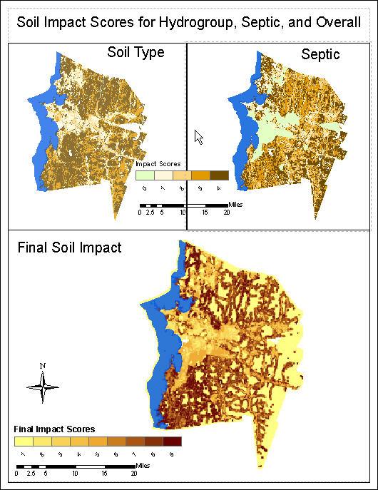
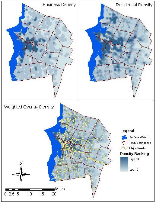
7 Sample Indicator: soils Density layer
8 Phase II Methods 1) Map a different set of indicators for entire County : Ecosystem Service Values, Impervious Surface, Forest Fragmentation, Distance to Water, Distance to Conserved Land, Distance to Development, Slope, Soil Type 1) Weight indicators to determine potential impact 2) Overlay CCRPC Planning Areas on prescriptive map 3) Evaluate existing boundaries and make recommendations

9 Phase II: Ecosystem Service Values Services provided by Ecosystems that increase human welfare should be documented as economic gain Methods Land Use enhanced from Landsat 30m image Ecosystem Values from edu Natural log of value was used for impact score


10 Results: Weighted Overlay Each impact layer normalized on ten digit scale Ran sensitivity analysis with multiple weights for different indicators Different weightings schemes were based on different findings in literature Followed same basic pattern with different ranges Resulted in different versions of final impact per capita Layer Weights used in Overlay (Percent Weighted) Run 1 Run 2 Run 3 Run 4 Run 5 Impervious Surface Forest Fragmentation Driving Time Water Buffers Soils Slope Run 6

11 Results: Per capita impact map Each of the six runs shows similar pattern of per capita impact, but we chose to focus on run 2, which represents happy medium of weights
 and sprawl (high impact, low density>> high per capita impact) Show that areas around existing urban and village centers are categorized as low per capita impact.")
12 Results: Categorization Applied threshold values (3 and 5) to run 2 impact map to categorize areas as urban (high impact, high density>> low per capita impact), rural (low impact, low density>> low per capita impact) and sprawl (high impact, low density>> high per capita impact) Show that areas around existing urban and village centers are categorized as low per capita impact. On average, suburbs farther from centers classed as sprawl.

13 Mapped weighted combination of second set of indicators to show where new development would likely have high ecological impact Shows low per capita impact near Burlington metro hub and village centers, increasing with distance in general Results:Phase II
 Areas designated metropolitan tend to have low average impact scores.")
14 Overlaid impact map on map of Chittenden County Regional Planning Commission non-rural planning areas; these show areas targeted for continued growth, transition, village style development, etc. Took average potential impact score by planning area polygon (next slide) Areas designated metropolitan tend to have low average impact scores. Many village centers and some transitional areas have high average scores indicating that small amounts of additional development in these areas will have a big environmental impact if not zoned correctly Zooming in to the level of fine detail (next slide) shows heterogeneous potential impact scores; means that within a village area growth could be targeted to minimize the environmental impact if planned Phase II Results

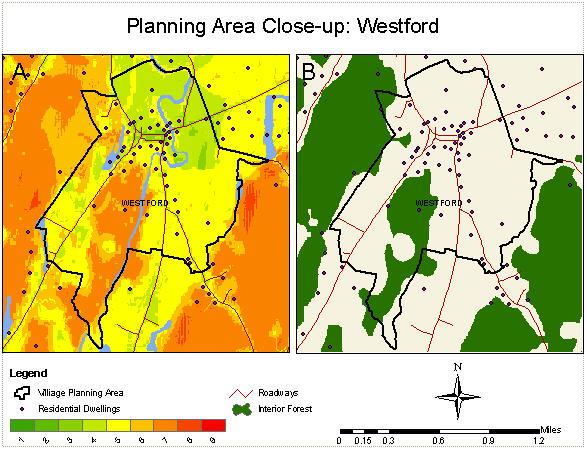
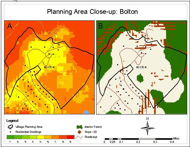
15 Results: Phase II
16 Implications and applications in the Northern Forest region Sprawl is a priority issue for residents of the Northern Forest region The problem has been having a systematic and grounded approach for defining it Without such a definition it is extremely hard to do planning to avoid it This provides an approach that can be easily replicated using standardized public data sets and basic spatial analysis methods This could prove particularly useful to local planning and zoning departments as they re-zone, to RPCs as they update their regional plans, and to the state, in updating the statewide land use policies. Executive Director of Chittenden County RPC is aware of project and will be debriefed on results These results will also be shared with staff of other RPCs.
17 Future directions This research will contribute to a new project being conducted by PI for US Department of Transportation, in which integrated land use/transportation simulation model is being run for Chittenden County, in collaboration with the County s RPC and Metropolitan Planning Organization (MPO). In this project simulations of land use are run under different policy scenarios. Results can be compared in terms of this sprawl index. We also hope to work with our collaborator on this project, the Vermont Forum on Sprawl, to help publicize this approach as an easy way for towns and regions to assess their land use patterns. In the future it may also be possible to develop a desktop application that automates the spatial analysis done manually in this project, allowing planners to easily replicate this approach
18 List of products Master s thesis: Developing and Applying Ecological Indicators of Suburban Sprawl: A Case Study for Chittenden County Vermont By Katrin Moffroid, approved October 2006 Included three papers, currently in revisions for submission to journals A new Geographic Information Systems methodology, which can be replicated by local and regional planning agencies A digital dataset and map layers of sprawl indicators for Chittenden County, VT, for use by town and county planners
The Road to Data in Baltimore
 Creating a parcel level database from high resolution imagery By Austin Troy and Weiqi Zhou University of Vermont, Rubenstein School of Natural Resources State and local planning agencies are increasingly
Fig 1. Steps in the EcoValue Project
 Assessing the Social and Economic Value of Ecosystem Services in the Northern Forest Region: A Geographic Information System (GIS) Approach to Landscape Valuation Principal Investigator(s): Dr. Matthew
Geospatial Assessment in Support of Urban & Community Forestry Programs
 Geospatial Assessment in Support of Urban & Community Forestry Programs Funded by the USDA Forest Service, State and Private Forestry, under Cooperative Agreement # 06-CA-112244225-338 with the University
LOOKING FOR THE RELATIONSHIP BETWEEN SPRAWL AND WATER QUALITY: A CASE STUDY OF GLOUCESTER COUNTY, NJ
 Middle States Geographer, 2006, 39:26-33 LOOKING FOR THE RELATIONSHIP BETWEEN SPRAWL AND WATER QUALITY: A CASE STUDY OF GLOUCESTER COUNTY, NJ Donna Moffett 1 and John Hasse 2 1 Department of Earth and
Rural Pennsylvania: Where Is It Anyway? A Compendium of the Definitions of Rural and Rationale for Their Use
 Rural Pennsylvania: Where Is It Anyway? A Compendium of the Definitions of Rural and Rationale for Their Use Pennsylvania Office of Rural Health 310 Nursing Sciences Building University Park, PA 16802
Summary Description Municipality of Anchorage. Anchorage Coastal Resource Atlas Project
 Summary Description Municipality of Anchorage Anchorage Coastal Resource Atlas Project By: Thede Tobish, MOA Planner; and Charlie Barnwell, MOA GIS Manager Introduction Local governments often struggle
C) Discuss two factors that are contributing to the rapid geographical shifts in urbanization on a global scale.
 Discuss two factors that are contributing to the rapid geographical shifts in urbanization on a global scale.") AP Human Geography Unit VII. Cities and Urban Land Use Free Response Questions FRQ 1 Rapid urbanization in Least Developed Countries (LDCs) has many profound impacts for the world. Answer the following
AP Human Geography Unit VII. Cities and Urban Land Use Free Response Questions FRQ 1 Rapid urbanization in Least Developed Countries (LDCs) has many profound impacts for the world. Answer the following
Most people used to live like this
 Urbanization Most people used to live like this Increasingly people live like this. For the first time in history, there are now more urban residents than rural residents. Land Cover & Land Use Land cover
Modeling Smart Growth in the Southeast Using Smart-SLEUTH. November 20, 2014 SOUTH ATLANTIC LCC WEB FORUM Monica A. Dorning
 Modeling Smart Growth in the Southeast Using Smart-SLEUTH November 20, 2014 SOUTH ATLANTIC LCC WEB FORUM Monica A. Dorning (Sub)Urbanization in the Southeast November 20, 2014 SOUTH ATLANTIC LCC WEB FORUM
GIS Geographical Information Systems. GIS Management
 GIS Geographical Information Systems GIS Management Difficulties on establishing a GIS Funding GIS Determining Project Standards Data Gathering Map Development Recruiting GIS Professionals Educating Staff
The Governance of Land Use
 The planning system The Governance of Land Use United Kingdom Levels of government and their responsibilities The United Kingdom is a unitary state with three devolved governments in Northern Ireland,
The Governance of Land Use
 The planning system Levels of government and their responsibilities The Governance of Land Use COUNTRY FACT SHEET NORWAY Norway is a unitary state with three levels of government; the national level, 19
RESIDENTIAL SATISFACTION IN THE CHANGING URBAN FORM IN ADELAIDE: A COMPARATIVE ANALYSIS OF MAWSON LAKES AND CRAIGBURN FARM, SOUTH AUSTRALIA
 RESIDENTIAL SATISFACTION IN THE CHANGING URBAN FORM IN ADELAIDE: A COMPARATIVE ANALYSIS OF MAWSON LAKES AND CRAIGBURN FARM, SOUTH AUSTRALIA by Michael Chadbourne BEPM (Hons) University of Adelaide Thesis
Too Close for Comfort
 Too Close for Comfort Overview South Carolina consists of urban, suburban, and rural communities. Students will utilize maps to label and describe the different land use classifications. Connection to
MPOs SB 375 LAFCOs SCAG Practices/Experiences And Future Collaborations with LAFCOs
 Connecting LAFCOs and COGs for Mutual Benefits MPOs SB 375 LAFCOs SCAG Practices/Experiences And Future Collaborations with LAFCOs Frank Wen, Manager Research & Analysis Land Use & Environmental Planning
Regional Growth Strategy Regional TOD Advisory Committee
 Regional Strategy Regional TOD Advisory Committee September 21, 2018 Overview Regional Geographies Transit-Oriented Development Goal Scenarios Next Steps 2 Schedule + Process September 6 Management Policy
Hennepin GIS. Tree Planting Priority Areas - Analysis Methodology. GIS Services April 2018 GOAL:
 Hennepin GIS GIS Services April 2018 Tree Planting Priority Areas - Analysis Methodology GOAL: To create a GIS data layer that will aid Hennepin County Environment & Energy staff in determining where to
Link to USGS Phase 6 Land Use Viewer website:
 Chesapeake Bay Program Phase 6 Land Use Review Frequently Asked Questions (FAQ) Link to USGS Phase 6 Land Use Viewer website: http://chesapeake.usgs.gov/phase6/ Sections: 1. Data Review and Production
Modeling and Predicting of Future Urban Growth in the Charleston, South Carolina Area
 Modeling and Predicting of Future Urban Growth in the Charleston, South Carolina Area Jeffery Allen Testimony presented to the U.S. Commission on Ocean Policy January 15, 2002 Charleston, South Carolina
Your web browser (Safari 7) is out of date. For more security, comfort and the best experience on this site: Update your browser Ignore
 is out of date. For more security, comfort and the best experience on this site: Update your browser Ignore") Your web browser (Safari 7) is out of date. For more security, comfort and the best experience on this site: Update your browser Ignore urban area For the complete encyclopedic entry with media resources,
Your web browser (Safari 7) is out of date. For more security, comfort and the best experience on this site: Update your browser Ignore urban area For the complete encyclopedic entry with media resources,
Land Accounts - The Canadian Experience
 Land Accounts - The Canadian Experience Development of a Geospatial database to measure the effect of human activity on the environment Who is doing Land Accounts Statistics Canada (national) Component
Jobs-Housing Fit: Linking Housing Affordability and Local Wages
 Jobs-Housing Fit: Linking Housing Affordability and Local Wages Alex Karner, PhD Assistant Professor School of City and Regional Planning Georgia Institute of Technology Chris Benner, PhD Dorothy E. Everett
Council Workshop on Neighbourhoods Thursday, October 4 th, :00 to 4:00 p.m. Burlington Performing Arts Centre
 Council Workshop on Neighbourhoods Thursday, October 4 th, 2012 1:00 to 4:00 p.m. Burlington Performing Arts Centre Agenda Introductions Warm-Up Exercise Presentation Exercise Neighbourhood Planning Break
The CRP stresses a number of factors that point to both our changing demographics and our future opportunities with recommendations for:
 Plan Overview The CRP represents the first broad planning initiative covering Lake, Porter and LaPorte counties. Unlike previous plans released by NIRPC, which focused primarily on transportation, the
Rural Alabama. Jennifer Zanoni. Geography Division U.S. Census Bureau. Alabama State Data Center 2018 Data Conference Tuscaloosa, Alabama
 Rural Alabama Jennifer Zanoni Geography Division U.S. Census Bureau Alabama State Data Center 2018 Data Conference Tuscaloosa, Alabama May 17, 2018 Agenda Census Geography Urban/Rural Definitions County-based
Forecasts for the Reston/Dulles Rail Corridor and Route 28 Corridor 2010 to 2050
 George Mason University Center for Regional Analysis Forecasts for the Reston/Dulles Rail Corridor and Route 28 Corridor 21 to 25 Prepared for the Fairfax County Department of Planning and Zoning Lisa
USING DOWNSCALED POPULATION IN LOCAL DATA GENERATION
 USING DOWNSCALED POPULATION IN LOCAL DATA GENERATION A COUNTRY-LEVEL EXAMINATION CONTENT Research Context and Approach. This part outlines the background to and methodology of the examination of downscaled
Developing Quality of Life and Urban- Rural Interactions in BSR
 Developing Quality of Life and Urban- Rural Interactions in BSR Sakari Saarinen Union of the Baltic Cities, Commission on Environment Seminar on Quality of Life in Small Communities, 27 May 2010, Kärdla,
Land Use in the context of sustainable, smart and inclusive growth
 Land Use in the context of sustainable, smart and inclusive growth François Salgé Ministry of sustainable development France facilitator EUROGI vice president AFIGéO board member 1 Introduction e-content+
Urbanization 5/17/2002 1
 Urbanization Study of processes of urbanization in sociology is called urban sociology. Urbanization is the process of increase in the percentage of a population living in cities. A city is a densely settled
SPIMA Spatial dynamics and strategic planning in metropolitan areas
 Targeted Analysis SPIMA Spatial dynamics and strategic planning in metropolitan areas Executive Summary Conference version 1 February 2018 0 1. Background To address the challenges of metropolitan development
EcoServ-GIS. EcoServ GIS Stage I. Why EcoServ GIS? 17/12/2012
 EcoServ-GIS Ecosystem Services Mapping: A Wildlife Trust GIS Toolkit to map ecosystem services at a county scale Dr Jonathan Winn Living Landscape Coordinator Durham Wildlife Trust Dr Chloe Bellamy Ecosystem
Vincent Goodstadt. Head of European Affairs METREX European Network
 Vincent Goodstadt Head of European Affairs METREX European Network METREX (Network of 50 European Metropolitan Regions and Areas ) Exchanging Knowledge (e.g. Benchmarking) Climate Change CO2/80/50 Expertise
How the science of cities can help European policy makers: new analysis and perspectives
 How the science of cities can help European policy makers: new analysis and perspectives By Lewis Dijkstra, PhD Deputy Head of the Economic Analysis Unit, DG Regional and European Commission Overview Data
Improving rural statistics. Defining rural territories and key indicators of rural development
 Improving rural statistics Defining rural territories and key indicators of rural development Improving rural statistics Improving Rural Statistics In 2016, the Global Strategy to improve Agricultural
Measuring urban sprawl in China by night time light images
 IOP Conference Series: Earth and Environmental Science PAPER OPEN ACCESS Measuring urban sprawl in China by night time light images To cite this article: Lu Liu and Lin Tang 2017 IOP Conf. Ser.: Earth
Analysis of urban sprawl phenomenon
 Analysis of urban sprawl phenomenon Detection of city growth based on spatiotemporal analysis and landscape metrics. Leopold Leśko University for Sustainable Development Eberswalde, 2013 Presentanion Outline
Regional Plan 4: Integrating Ecosystem Services Mapping into Regional Land Use Planning
 Rural-Urban Outlooks: Unlocking Synergies (ROBUST) ROBUST receives funding from the European Union s Horizon 2020 research and innovation programme under grant agreement No 727988.* October 2018 Natural
APPLICATIONS OF EARTHQUAKE HAZARD MAPS TO LAND-USE AND EMERGENCY PLANNING EXAMPLES FROM THE PORTLAND AREA
 APPLICATIONS OF EARTHQUAKE HAZARD MAPS TO LAND-USE AND EMERGENCY PLANNING EXAMPLES FROM THE PORTLAND AREA O. Gerald Uba Metro, Portland, Oregon OVERVIEW The extent to which we understand "below ground"
URBAN CHANGE DETECTION OF LAHORE (PAKISTAN) USING A TIME SERIES OF SATELLITE IMAGES SINCE 1972
 USING A TIME SERIES OF SATELLITE IMAGES SINCE 1972") URBAN CHANGE DETECTION OF LAHORE (PAKISTAN) USING A TIME SERIES OF SATELLITE IMAGES SINCE 1972 Omar Riaz Department of Earth Sciences, University of Sargodha, Sargodha, PAKISTAN. omarriazpk@gmail.com ABSTRACT
URBAN CHANGE DETECTION OF LAHORE (PAKISTAN) USING A TIME SERIES OF SATELLITE IMAGES SINCE 1972 Omar Riaz Department of Earth Sciences, University of Sargodha, Sargodha, PAKISTAN. omarriazpk@gmail.com ABSTRACT
AP Human Geography Free-response Questions
 AP Human Geography Free-response Questions 2000-2010 2000-preliminary test 1. A student concludes from maps of world languages and religions that Western Europe has greater cultural diversity than the
CLAREMONT MASTER PLAN 2017: LAND USE COMMUNITY INPUT
 Planning and Development Department 14 North Street Claremont, New Hampshire 03743 Ph: (603) 542-7008 Fax: (603) 542-7033 Email: cityplanner@claremontnh.com www.claremontnh.com CLAREMONT MASTER PLAN 2017:
HORIZON 2030: Land Use & Transportation November 2005
 PROJECTS Land Use An important component of the Horizon transportation planning process involved reviewing the area s comprehensive land use plans to ensure consistency between them and the longrange transportation
The role of community in urban regeneration: mixed use areas approach in USA
 The role of community in urban regeneration: mixed use areas approach in USA Outline 1. Thesis 2. Main topics 3. Urban regeneration and community 4. Community involvement methods 5. Policies: EU vs USA
Progress and Land-Use Characteristics of Urban Sprawl in Busan Metropolitan City using Remote sensing and GIS
 Progress and Land-Use Characteristics of Urban Sprawl in Busan Metropolitan City using Remote sensing and GIS Homyung Park, Taekyung Baek, Yongeun Shin, Hungkwan Kim ABSTRACT Satellite image is very usefully
Environment and Natural Resources Trust Fund 2010 Request for Proposals (RFP)
") LCCMR ID: 141-E2 Project Title: Environment and Natural Resources Trust Fund 2010 Request for Proposals (RFP) Monitoring and Modeling Minnesota Landscapes and Ecosystem Services LCCMR 2010 Funding Priority:
LCCMR ID: 141-E2 Project Title: Environment and Natural Resources Trust Fund 2010 Request for Proposals (RFP) Monitoring and Modeling Minnesota Landscapes and Ecosystem Services LCCMR 2010 Funding Priority:
To: Ross Martin, Lisa Stapleton From: Brad Lind Subject: Joint Funding Agreement with USGS for 2012 Imagery Date: March 14, 2012.
 To: Ross Martin, Lisa Stapleton From: Brad Lind Subject: Joint Funding Agreement with USGS for 2012 Imagery Date: March 14, 2012 Attached are two copies of the Joint Funding Agreement (JFA) between SanGIS
Ecological Land Cover Classification For a Natural Resources Inventory in the Kansas City Region, USA
 Ecological Land Cover Classification For a Natural Resources Inventory in the Kansas City Region, USA by Applied Ecological Services, Inc. In cooperation with the Mid-America Regional Council 600 Broadway,
The Spatial Structure of Cities: International Examples of the Interaction of Government, Topography and Markets
 Module 2: Spatial Analysis and Urban Land Planning The Spatial Structure of Cities: International Examples of the Interaction of Government, Topography and Markets Alain Bertaud Urbanist Summary What are
 www.ct.gov/opm/cdplan Role of the Locational Guide Map State agencies shall not provide funding for certain growth-related projects unless such projects are located within a priority funding area LGM shall
Regional Growth Strategy Work Session Growth Management Policy Board
 Regional Growth Strategy Work Session Growth Management Policy Board September 6, 2018 1 Overview Recap June GMPB work session Objectives and outcomes Regional geographies Growth scenarios Breakout Discussion:
Introduction and Project Overview
 Greater New Orleans Regional Land Use Modeling GIS Techniques in a P olitical C ontext Louisiana Remote Sensing and GIS Workshop Wednesday, April 24, 2013 Working Towards a Shared Regional Vision Introduction
An Internet-Based Integrated Resource Management System (IRMS)
") An Internet-Based Integrated Resource Management System (IRMS) Third Quarter Report, Year II 4/1/2000 6/30/2000 Prepared for Missouri Department of Natural Resources Missouri Department of Conservation
An Internet-Based Integrated Resource Management System (IRMS) Third Quarter Report, Year II 4/1/2000 6/30/2000 Prepared for Missouri Department of Natural Resources Missouri Department of Conservation
Facts and Findings. Exhibit A-1
 Exhibit A-1 Facts and Findings The county periodically prepares coordinated countywide forecasts for all the cities in the county and the unincorporated area. These forecasts can be used by cities as a
ADMINISTRATION DEPARTMENT Land Management Information Center. An Inventory of Its Records
 MINNESOTA HISTORICAL SOCIETY Minnesota State Archives ADMINISTRATION DEPARTMENT Land Management Information Center An Inventory of Its Records OVERVIEW OF THE RECORDS Agency: Series Title: Land Management
Welcome to GCSE Geography. Where will it take us today?
 Welcome to GCSE Geography Where will it take us today? Urban Futures Dynamic Development Resource Reliance UK in the 21 st Century Global Hazards Changing Climate Distinctive Landscapes Sustaining Ecosystems
Urban Spatial Scenario Design Modelling (USSDM) in Dar es Salaam: Background Information
 in Dar es Salaam: Background Information") Urban Spatial Scenario Design Modelling (USSDM) in Dar es Salaam: Background Information Modelling urban settlement dynamics in Dar es Salaam Revision: 2 (July 2013) Prepared by: Katja Buchta TUM team
Urban Spatial Scenario Design Modelling (USSDM) in Dar es Salaam: Background Information Modelling urban settlement dynamics in Dar es Salaam Revision: 2 (July 2013) Prepared by: Katja Buchta TUM team
Transport Planning in Large Scale Housing Developments. David Knight
 Transport Planning in Large Scale Housing Developments David Knight Large Scale Housing Developments No longer creating great urban spaces in the UK (Hall 2014) Transport Planning Transport planning processes
Land Cover Classification Mapping & its uses for Planning
 Land Cover Classification Mapping & its uses for Planning What is Land Cover Classification Mapping? Examples of an actual product Why use Land Cover Classification Mapping for planning? Possible uses
Proposed Scope of Work Village of Farmingdale Downtown Farmingdale BOA Step 2 BOA Nomination Study / Draft Generic Environmental Impact Statement
 Proposed Scope of Work Village of Farmingdale Downtown Farmingdale BOA Step 2 BOA Nomination Study / Draft Generic Environmental Impact Statement The scope of work that follows incorporates and covers
Land Use of the Geographical Information System (GIS) and Mathematical Models in Planning Urban Parks & Green Spaces
 and Mathematical Models in Planning Urban Parks & Green Spaces") Land Use of the Geographical Information System (GIS) and Mathematical Models in Planning Urban Key words: SUMMARY TS 37 Spatial Development Infrastructure Linkages with Urban Planning and Infrastructure
Land Use of the Geographical Information System (GIS) and Mathematical Models in Planning Urban Key words: SUMMARY TS 37 Spatial Development Infrastructure Linkages with Urban Planning and Infrastructure
MARYLAND S LAND USE/LAND COVER MAP AND ASSOCIATED ANALYSIS
 MARYLAND S LAND USE/LAND COVER MAP AND ASSOCIATED ANALYSIS Maryland Department of Planning Daniel Baldwin Stephanie Martins November 19, 2012 http://www.planning.maryland.gov/ PURPOSE The primary purpose
Spatial Modeling of Land Use and Land Cover Change
 Spatial Modeling of Land Use and Land Cover Change Daniel G. Brown Environmental Spatial Analysis Lab School of Natural Resources and Environment University of Michigan Synthesis Products Modeling Chapter
Operational Definitions of Urban, Rural and Urban Agglomeration for Monitoring Human Settlements
 Operational Definitions of Urban, Rural and Urban Agglomeration for Monitoring Human Settlements By Markandey Rai United Nations Human Settlements Programme PO Box-30030 Nairobi, Kenya Abstract The United
AP Human Geography Syllabus
 AP Human Geography Syllabus Textbook The Cultural Landscape: An Introduction to Human Geography. Rubenstein, James M. 10 th Edition. Upper Saddle River, N.J.: Prentice Hall 2010 Course Objectives This
OREGON POPULATION FORECAST PROGRAM
 OREGON POPULATION FORECAST PROGRAM PROGRAM OVERVIEW BACKGROUND Beginning in 1973 with the passage of Senate Bill (SB) 100, Oregon s growth management system has relied on population forecasts as the primary
Southwest LRT Habitat Analysis. May 2016 Southwest LRT Project Technical Report
 Southwest LRT Habitat Analysis Southwest LRT Project Technical Report This page intentionally blank. Executive Summary This technical report describes the habitat analysis that was performed to support
Date: June 19, 2013 Meeting Date: July 5, Consideration of the City of Vancouver s Regional Context Statement
 Section E 1.5 To: From: Regional Planning and Agriculture Committee Lee-Ann Garnett, Senior Regional Planner Planning, Policy and Environment Department Date: June 19, 2013 Meeting Date: July 5, 2013 Subject:
Huron Creek Watershed 2005 Land Use Map
 Huron Creek Watershed 2005 Land Use Map Created By: Linda Kersten, 12/20/06 Created For: MTU Introduction to GIS Class (FW 5550) The Huron Creek Watershed Advisory Committee Michigan Technological University,
c. What is the most distinctive above ground result of high land costs and intensive land use? i. Describe the vertical geography of a skyscraper?
 AP Human Geography Unit 7b Guided Reading: Urban Patterns and Social Issues Mr. Stepek Key Issue #1: Why Do Services Cluster Downtown? (Rubenstein p 404 410) 1. What is the CBD? What does it contain and
Implementation of the ESPON 2020 cooperation program. 16 January 2017 Anneloes van Noordt
 Implementation of the ESPON 2020 cooperation program 16 January 2017 Anneloes van Noordt Outline! ESPON Cooperation Program! Specific Objectives! Applied Research! Targeted Analysis! Database & Tools!
AP Human Geography. Course Outline Geography: Its Nature and Perspectives: Weeks 1-4
 AP Human Geography The Course The AP Human Geography course is designed to provide secondary students with the equivalent of one semester of a college introductory human geography class. The purpose of
2040 MTP and CTP Socioeconomic Data
 SE Data 6-1 24 MTP and CTP Socioeconomic Data Purpose of Socioeconomic Data The socioeconomic data (SE Data) shows the location of the population and employment, median household income and other demographic
What do we think of our cities?
 What do we think of our cities? Do we think of cities as beautiful places? Are cities healthy places to live? Do most of the world s people live in cities? Do cities function like other natural systems,
Geospatial Data, Services, and Products. National Surveying, mapping and geospatial conference
 Geospatial Data, Services, and Products Federal Programs -- USDA NRCS National Surveying, mapping and geospatial conference March 15, 2016 NRCS Applications using Geosaptial Products & Services Field
A spatial literacy initiative for undergraduate education at UCSB
 A spatial literacy initiative for undergraduate education at UCSB Mike Goodchild & Don Janelle Department of Geography / spatial@ucsb University of California, Santa Barbara ThinkSpatial Brown bag forum
CHAPTER 4 HIGH LEVEL SPATIAL DEVELOPMENT FRAMEWORK (SDF) Page 95
 Page 95") CHAPTER 4 HIGH LEVEL SPATIAL DEVELOPMENT FRAMEWORK (SDF) Page 95 CHAPTER 4 HIGH LEVEL SPATIAL DEVELOPMENT FRAMEWORK 4.1 INTRODUCTION This chapter provides a high level overview of George Municipality s
CHAPTER 4 HIGH LEVEL SPATIAL DEVELOPMENT FRAMEWORK (SDF) Page 95 CHAPTER 4 HIGH LEVEL SPATIAL DEVELOPMENT FRAMEWORK 4.1 INTRODUCTION This chapter provides a high level overview of George Municipality s
Problems In Large Cities
 Chapter 11 Problems In Large Cities Create a list of at least 10 problems that exist in large cities. Consider problems that you have read about in this and other chapters and/or experienced yourself.
Bishkek City Development Agency. Urban Planning Bishkek
 Bishkek City Development Agency Urban Planning Bishkek Bishkek City Development Agency Official name City budget Population Area GRP Import value Export value External trade turnover Foreign direct investments
New Frameworks for Urban Sustainability Assessments: Linking Complexity, Information and Policy
 New Frameworks for Urban Sustainability Assessments: Linking Complexity, Information and Policy Moira L. Zellner 1, Thomas L. Theis 2 1 University of Illinois at Chicago, Urban Planning and Policy Program
Valuation of environmental amenities in urban land price: A case study in the Ulaanbaatar city, Mongolia
 1989 1990 1991 1992 1993 1994 1995 1996 1997 1998 1999 2000 2001 2002 2003 2004 2005 2006 2007 2008 2009 2010 2011 Population Valuation of environmental amenities in urban land price: A case study in the
Riocan Centre Study Area Frontenac Mall Study Area Kingston Centre Study Area
 OVERVIEW the biggest challenge of the next century (Dunham Jones, 2011). New books are continually adding methods and case studies to a growing body of literature focused on tackling this massive task.
The National Spatial Strategy
 Purpose of this Consultation Paper This paper seeks the views of a wide range of bodies, interests and members of the public on the issues which the National Spatial Strategy should address. These views
BIODIVERSITY CONSERVATION HABITAT ANALYSIS
 BIODIVERSITY CONSERVATION HABITAT ANALYSIS A GIS Comparison of Greater Vancouver Regional Habitat Mapping with Township of Langley Local Habitat Mapping Preface This report was made possible through the
California Urban and Biodiversity Analysis (CURBA) Model
 Model") California Urban and Biodiversity Analysis (CURBA) Model Presentation Overview Model Overview Urban Growth Model Policy Simulation and Evaluation Model Habitat Fragmentation Analysis Case Study: Santa
California Urban and Biodiversity Analysis (CURBA) Model Presentation Overview Model Overview Urban Growth Model Policy Simulation and Evaluation Model Habitat Fragmentation Analysis Case Study: Santa
Copernicus Land HRL Imperviousness: 2012 dataset, indicator Title
 Copernicus Land HRL Imperviousness: 2012 dataset, 06-09 indicator and outlook Title 2015+ Tobias LANGANKE First name SURNAME Project manager, Copernicus Position land services Name European of the Environment
National planning report for Denmark
 National planning report for Denmark from the Minister for Environment and Energy Local identity and new challenges Summary 2000 1 CONTENTS 4 PREFACE: REGIONAL DEVELOPMENT AND SPATIAL PLANNING 6 1. BALANCED
GREEN GROWTH TOOLBOX. Nature-Friendly Planning. Jeff Marcus North Carolina Wildlife Resources Commission
 GREEN GROWTH TOOLBOX Nature-Friendly Planning Jeff Marcus North Carolina Wildlife Resources Commission Growth in North Carolina NC is the 5 th fastest growing state 3 million people will move to NC over
Internet GIS Sites. 2 OakMapper webgis Application
 Internet GIS Sites # Name URL Description 1 City of Sugar Land http://www.sugarlandtx.gov/index.htm It is a city in Texas with 65,000 Residents. The City of Sugar Land, Texas, provides ArcIMS-based maps
ESTIMATING LAND VALUE AND DISASTER RISK IN URBAN AREA IN YANGON, MYANMAR USING STEREO HIGH-RESOLUTION IMAGES AND MULTI-TEMPORAL LANDSAT IMAGES
 ESTIMATING LAND VALUE AND DISASTER RISK IN URBAN AREA IN YANGON, MYANMAR USING STEREO HIGH-RESOLUTION IMAGES AND MULTI-TEMPORAL LANDSAT IMAGES Tanakorn Sritarapipat 1 and Wataru Takeuchi 1 1 Institute
BIG IDEAS. Area of Learning: SOCIAL STUDIES Urban Studies Grade 12. Learning Standards. Curricular Competencies
 Area of Learning: SOCIAL STUDIES Urban Studies Grade 12 BIG IDEAS Urbanization is a critical force that shapes both human life and the planet. The historical development of cities has been shaped by geographic,
Census Urban Area Comparisons, 2000 to 2010
 THE HONORABLE ROGERS Mayor ANDERSON, Karl Dean, CHAIRMAN Chairman Census Urban Area Comparisons, 2000 to 2010 TCC May 2, 2012 MPOs/RPOs in Tennessee Regional Geographies in Middle TN Nashville MPO Clarksville
TOWARDS CLIMATE-RESILIENT COASTAL MANAGEMENT: OPPORTUNITIES FOR IMPROVED ICZM IN BELIZE
 TOWARDS CLIMATE-RESILIENT COASTAL MANAGEMENT: OPPORTUNITIES FOR IMPROVED ICZM IN BELIZE CHANTALLE SAMUELS Coastal Zone Management Authority and Institute The Caribbean Community Climate Change Centre VULNERABILITY
State initiative following up the 2006 national planning report
 18 ness districts and public institutions, should be integrated with the opportunities for public transport services. State initiative following up the 2006 national planning report The Ministry of the
Neighborhood social characteristics and chronic disease outcomes: does the geographic scale of neighborhood matter? Malia Jones
 Neighborhood social characteristics and chronic disease outcomes: does the geographic scale of neighborhood matter? Malia Jones Prepared for consideration for PAA 2013 Short Abstract Empirical research
CUYAHOGA COUNTY URBAN TREE CANOPY & LAND COVER MAPPING
 CUYAHOGA COUNTY URBAN TREE CANOPY & LAND COVER MAPPING FINAL REPORT M IKE GALVIN S AVATREE D IRECTOR, CONSULTING GROUP P HONE: 914 403 8959 E MAIL: MGALVIN@SAVATREE. COM J ARLATH O NEIL DUNNE U NIVERSITY
Regional Economic Competitiveness Local Comprehensive Planning. An End-of-year Update to the Metropolitan Council Community Development Committee
 Regional Economic Competitiveness Local Comprehensive Planning An End-of-year Update to the Metropolitan Council Community Development Committee 12/21/2015 Regional Economic Competitiveness The ability
HSC Geography. Year 2013 Mark Pages 10 Published Jul 4, Urban Dynamics. By James (97.9 ATAR)
") HSC Geography Year 2013 Mark 92.00 Pages 10 Published Jul 4, 2017 Urban Dynamics By James (97.9 ATAR) Powered by TCPDF (www.tcpdf.org) Your notes author, James. James achieved an ATAR of 97.9 in 2013 while
HSC Geography Year 2013 Mark 92.00 Pages 10 Published Jul 4, 2017 Urban Dynamics By James (97.9 ATAR) Powered by TCPDF (www.tcpdf.org) Your notes author, James. James achieved an ATAR of 97.9 in 2013 while
CERTIFIED RESOLUTION. introduction: and dated May 29, 2017, as attached, as appropriate
 15322 Buena Vista Avenue, White Rock BC, Canada V4B 1Y6 www.whiterockcity.ca City of White Rock P: 604.541.22121 F: 604.541.9348 /2tC% City Clerk s Office IT E ROC K June 13,2017 Stephanie Lam, Deputy
Assessment of Sustainable Land Use within the Town Planning Process Experiences with a Multi Criteria Approach (MCA)
") Assessment of Sustainable Land Use within the Town Planning Process Experiences with a Multi Criteria Approach (MCA) Dipl.-Geogr. Sophie Schetke Dipl.-Ing. Benedikt Frielinghaus, University of Bonn, Germany
Assessment of Sustainable Land Use within the Town Planning Process Experiences with a Multi Criteria Approach (MCA) Dipl.-Geogr. Sophie Schetke Dipl.-Ing. Benedikt Frielinghaus, University of Bonn, Germany