Operational Definitions of Urban, Rural and Urban Agglomeration for Monitoring Human Settlements
|
|
|
- Geraldine Lisa Wells
- 5 years ago
- Views:
Transcription
1 Operational Definitions of Urban, Rural and Urban Agglomeration for Monitoring Human Settlements By Markandey Rai United Nations Human Settlements Programme PO Box Nairobi, Kenya

2 Abstract The United Nations Human Settlements Programme (UN- HABITAT) is responsible for monitoring the Target 11 of Goal 7 of the Millennium Development Goals (MDG's( MDG's) ) in addition to its mandate to monitor and report on the progress made in implementation of the Habitat Agenda. The paper will discuss the problems and difficulties in collecting data with common operational definition of urban/rural and urban agglomerations in various regions as well as reliability of information provided by reporting authorities. The various opinion on the issue of how to define the cities boundaries for future data collection and concept of built-up up and densely populated area's role in it will also be discussed for future data collection.
 Indicator 32: Proportion of households with secure tenure")
3 Target 11 of goal 7 of the Millennium Development goals (MDG s( MDG s) Goal 7: Ensure environmental sustainability Target 11: By 2020 to have achieved a significant improvement in the lives of at least 100 million slum dwellers Indicator 31: Proportion of urban population with access to improved sanitation (UNICEF) Indicator 32: Proportion of households with secure tenure (UN-HABITAT)
4 The Expert Group Meeting (EGM) The overall objectives of the Expert Group Meting were: The long term objective was to strengthen capacity of countries to collect, compile and analyze urban indicators, in order to do comparisons based on harmonized definitions and classifications at national and city level. The immediate objective was to discuss and come out with the operational definitions of urban and rural areas for collection of comparable indicators as well establishing the criteria for defining city boundaries of the Urban Agglomerations
5 Urban and rural is defined based on some characteristics Population size threshold Population density Contiguity of build-up up area Political status Proportion of the labor force engaged in non-agricultural work Presence of particular services and activities
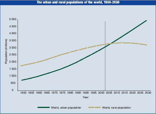
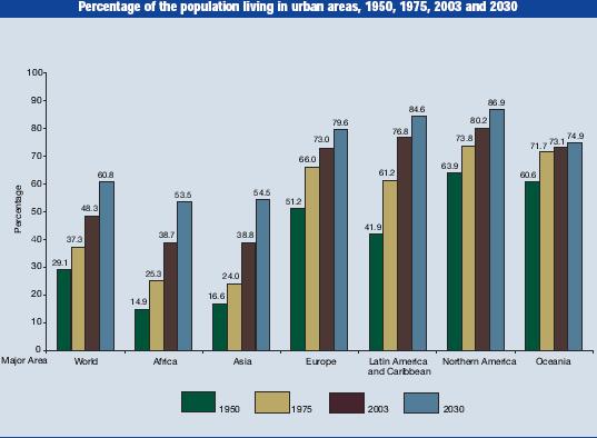
6 Urbanization Facts By 2007 about 50 percent of the world s population will live in urban areas By 2030, 60 percent will be urban In 2000 urban population reached 2.9 billion By 2030, it is expected to reach 5 billion Almost all urban growth will be absorbed in developing regions.
7
8
 will increase from 20 in 2003 to 22 in 2015.")
9 Mega Cities Growth The number of cities with 5 million or more inhabitants is projected to rise from 46 in 2003 to 61 in Among these, the number of mega-cities (with 10 million inhabitants or more) will increase from 20 in 2003 to 22 in most of these large cities are in developing countries, and by 2015, 45 out of 61 cities are expected to be from the less developed regions.5 Large urban agglomerations are not necessarily experiencing fast population growth. Of the 20 mega-cities identified in 2003, almost half experienced population growth below 1.5 per cent between 1975 and 2000 and just 6 grew at rates above 3 percent: Dhaka in Bangladesh (6.2 per cent per year); Lagos in Nigeria(6.1); Delhi(4.1), Karachi(3.7) and Mumbai(Bombay)(3.1)in India; and Jakarta in Indonesia (3.3). During , 11 mega-cities are projected to experience population growth below 1.5 per cent and five will remain with population growth rates above 3 percent.6
10 No common universal definition for urban/rural areas or population Belarus Urban localities are human settlements that in accordance with legislation l have the status of towns Canada Urban areas include all greater metropolitan areas (even though they contain some rural areas) and smaller metropolitan areas. Urban areas have a minimum population concentration of 1000 people and a population density of at least 400 per square kilometer based on the previous census population counts Dominic Republic Urban zones refer to areas in municipalities Estonia Urban areas include towns and townships, while rural areas include villages Libya Urban refers to every district of or more inhabitants Mexico Urban refers to localities with population over 2500.
11 No common universal definition for urban/rural areas or population. Sweden Locality is a group of buildings normally not more than 200 meters apart from each other and having at least 200 inhabitants. In Sweden localities l are defined as urban and all areas outside the localities as rural. Thailand Urban refers to municipal areas Turkey Urban refers to settlements with population of and over. United Kingdom Urban refers to built up area with a population of more than approximately one thousand (1000) based on population as at United Stated of America Census Bureau-defined Urbanized Areas (UAs( UAs) ) are defined to represent human settlements with over50, 000 people. A UA is defined by the e Census bureau as an area consisting of a central place (s) and adjacent urban fringe that together have a minimum residential population of at least 50,000 people and generally an overall population density of at least1,000 people per square mile of the land area
12 Analysis of urban definition 105 countries based their urban data on administrative criteria, limiting it to the boundaries of state or provincial capitals, municipalities or other local jurisdictions; 83 use this as their r sole method of distinguishing urban from rural. 100 countries define cities by population size or population density,, with minimum concentrations ranging broadly, from 200 to inhabitants; 57 use this as their sole urban criterion. 25 countries specify economic characteristics as significant, though not exclusive, in defining cities-typically, typically, the proportion of the labour force employed in non-agricultural activities 18 countries count the availability of urban infrastructure in their definitions, including the presence of paved streets, water supply systems, sewerage systems, or electric lighting. 25 countries provide no definition of urban at all 6 countries regard their entire population as urban
13 Definition of Urban Agglomeration Urban Agglomeration comprises the city or town proper and also the suburban fringe or thickly settled territory lying outside, but adjacent to, its boundaries. A single urban agglomeration may comprise several cities or towns and their suburban fringes. The administrative city (city proper) as the area of a population centre located within municipal boundaries designated as such by the central government for management, legislative and administrative purposes. Metropolitan area is defined as a politically defined urban area set up for planning or administration purposes which may combine several jurisdictions (municipalities or cities).
 Large Cities Statistics Project (LCSP) Expert Group Meeting in 2002 and Inter-agency group meetings")
14 Different forums for definition Principles and Recommendations for Population and Housing Censuses Global Urban Observatory (GUO ) Large Cities Statistics Project (LCSP) Expert Group Meeting in 2002 and Inter-agency group meetings on MDG s

15 Agreement on CityC boundries For comparative city statistics and indicators, it is important to have an agreement to have defined city boundary. For city level data, the standard area of reference should be the urban agglomeration. When the data for the agglomeration is not available then data for the metropolitan area should be provided with a note. The boundary of the urban agglomeration should be clearly defined with the help of local authorities.

16 Geographical Information System (GIS) Defining the boundaries of the urban agglomerations and for collecting data for the sample cities.

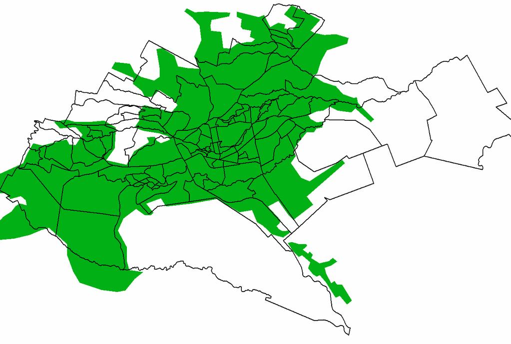
17 Nairobi

18 Nairobi city boundary
19 References World Urbanization Prospect 2001 World Urbanization prospect 2003 Ibid Ibid Ibid Ibid Ramachandran,, A., The Urban Challenge: A collection of lectures delivered by Dr. A Ramachandran, Principles and Recommendations for Population and Housing Censuses, Rev 1, New York 1998 Ibid Hardoy J.E. and Satterthwaite D, Squatter Citizen: Life in the urban third World. Earthscan Publication, London 1989 Rai, M. Urban Indicators for Policy Making, Cities and Regions, October Cities-International Yearbook of large Cities statistics, Network on urban Research in the European Union, 1997 (Habitat), 1996 Madrid.


20
Global City Definition
 Regional Training Workshop on Human Settlement Indicators Global City Definition Dennis Mwaniki Global Urban Observatory, Research and Capacity Development Branch, UN-Habitat Bangkok, Thailand Outline
Measuring Disaster Risk for Urban areas in Asia-Pacific
 Measuring Disaster Risk for Urban areas in Asia-Pacific Acknowledgement: Trevor Clifford, Intl Consultant 1 SDG 11 Make cities and human settlements inclusive, safe, resilient and sustainable 11.1: By
City definitions. Sara Ben Amer. PhD Student Climate Change and Sustainable Development Group Systems Analysis Division
 City definitions Sara Ben Amer PhD Student Climate Change and Sustainable Development Group Systems Analysis Division sbea@dtu.dk Contents 1. Concept of a city 2. Need for the city definition? 3. Challenges
VII. PROCEDURES TO ESTIMATE AND PROJECT THE POPULATION OF URBAN AREAS AND URBAN AGGLOMERATIONS
 VII. PROCEDURES TO ESTIMATE AND PROJECT THE POPULATION OF URBAN AREAS AND URBAN AGGLOMERATIONS The estimation and projection of the urban population is based on observed changes in the proportion of the
Concepts, definitions and data sources for the study of urbanization: the 2030 Agenda for Sustainable Development
 \ UNITED NATIONS EXPERT GROUP MEETING ON SUSTAINABLE CITIES, HUMAN MOBILITY AND INTERNATIONAL MIGRATION Population Division Department of Economic and Social Affairs United Nations Secretariat New York
Improving rural statistics. Defining rural territories and key indicators of rural development
 Improving rural statistics Defining rural territories and key indicators of rural development Improving rural statistics Improving Rural Statistics In 2016, the Global Strategy to improve Agricultural
SDI Developments in the World s Currently Existing Mega Cities
 SDI Developments in the World s Currently Existing Mega Cities Silke Boos and Hartmut Müller FIG Working Week 2009 Surveyors Key Role in Accelerated Development, Eilat, Israel, 3-8 May 2009 TS 1B SDI in
Indicator : Average share of the built-up area of cities that is open space for public use for all, by sex, age and persons with disabilities
 Goal 11: Make cities and human settlements inclusive, safe, resilient and sustainable Target 11.7: By 2030, provide universal access to safe, inclusive and accessible, green and public spaces, in particular
Geographic Boundaries of Population Census of Japan 1
 UNITED NATIONS SECRETARIAT ESA/STAT/AC.279/P20 Department of Economic and Social Affairs October 2013 Statistics Division English only United Nations Expert Group on the Integration of Statistical and
ReCAP Status Review of the Updated Rural Access Index (RAI) Stephen Vincent, Principal Investigator
 Stephen Vincent, Principal Investigator") ReCAP Status Review of the Updated Rural Access Index (RAI) Stephen Vincent, Principal Investigator Establishment of RAI in 2005/2006 2006 Definition of the RAI Note by Peter Roberts Dated September 2005
ReCAP Status Review of the Updated Rural Access Index (RAI) Stephen Vincent, Principal Investigator Establishment of RAI in 2005/2006 2006 Definition of the RAI Note by Peter Roberts Dated September 2005
2/25/2019. Taking the northern and southern hemispheres together, on average the world s population lives 24 degrees from the equator.
 Where is the world s population? Roughly 88 percent of the world s population lives in the Northern Hemisphere, with about half north of 27 degrees north Taking the northern and southern hemispheres together,
Population Change. Alessandro Alasia Agriculture Division Statistics Canada. (ICRPS) Summer School 2009
 Summer School 2009") Population Change in Rural Areas Seminar presented by Alessandro Alasia Agriculture Division Statistics Canada alessandro.alasia@statcan.gc.ca International Comparative Rural Policy Studies (ICRPS) Summer
Population Change in Rural Areas Seminar presented by Alessandro Alasia Agriculture Division Statistics Canada alessandro.alasia@statcan.gc.ca International Comparative Rural Policy Studies (ICRPS) Summer
Migration and Urban Decay
 Migration and Urban Decay Asian Experiences Shekhar Mukherji RAWAT PUBLICATIONS Jaipur New Delhi Bangalore Mumbai Contents Preface List of Tables List of Figures ix xv xix Introduction 1 Very Crucial Urban
GIS (GEOGRAPHICAL INFORMATION SYSTEMS) AS A FACILITATION TOOL FOR SUSTAINABLE DEVELOPMENT IN AFRICA
 AS A FACILITATION TOOL FOR SUSTAINABLE DEVELOPMENT IN AFRICA") GIS (GEOGRAPHICAL INFORMATION SYSTEMS) AS A FACILITATION TOOL FOR SUSTAINABLE DEVELOPMENT IN AFRICA a presentation by Elizabeth Hicken GDEST Conference on Geospatial Sciences for Sustainable Development
GIS (GEOGRAPHICAL INFORMATION SYSTEMS) AS A FACILITATION TOOL FOR SUSTAINABLE DEVELOPMENT IN AFRICA a presentation by Elizabeth Hicken GDEST Conference on Geospatial Sciences for Sustainable Development
Economic and Social Council
 United Nations Economic and Social Council 28 December 2000 Original: English E/CN.3/2001/2 Statistical Commission Thirty-second session 6-9 March 2001 Item 3 (a) of the provisional agenda * Demographic
Developing a global, peoplebased definition of cities and settlements
 Developing a global, peoplebased definition of cities and settlements By Lewis Dijkstra, Lewis.Dijkstra@ec.europa.eu Head of the Economic Analysis Sector DG for Regional and Urban Policy, Regional & Urban
Sharthi Laldaparsad Statistics South Africa, Policy Research & Analysis. Sub-regional workshop on integration of administrative data,
 Sub-regional workshop on integration of administrative data, big data and geospatial information for the compilation of SDG indicators and International Workshop on Global Fundamental Geospatial Data Themes
Economic and Social Council
 United Nations Economic and Social Council Distr.: General 19 December 2018 Original: English Statistical Commission Fiftieth session 5 8 March 2019 Item 3 (o) of the provisional agenda* Items for discussion
Achieving the Vision Geo-statistical integration addressing South Africa s Developmental Agenda. geospatial + statistics. The Data Revolution
 Achieving the Vision Geo-statistical integration addressing South Africa s Developmental Agenda geospatial + statistics The Data Revolution humble beginnings, present & future - South Africa UN World Data
Valuation of environmental amenities in urban land price: A case study in the Ulaanbaatar city, Mongolia
 1989 1990 1991 1992 1993 1994 1995 1996 1997 1998 1999 2000 2001 2002 2003 2004 2005 2006 2007 2008 2009 2010 2011 Population Valuation of environmental amenities in urban land price: A case study in the
Disaggregation according to geographic location the need and the challenges
 International Seminar On United Nations Global Geospatial Information Management Disaggregation according to geographic location the need and the challenges 6 th 7 th November 2018 Tribe Hotel, Nairobi,
BASE FOR. New York. in this paper Nations or. New York University.
 UNITED NATIONS N EXPERT GROUP MEETING ON STRENGTHENING THE DEMOGRAPHIC EVIDENCE BASE FOR THE POST-2015 DEVELOPMENT AGENDA Population Division Department of Economic and Social Affairs United Nations Secretariat
AFRICAN URBANIZATION: SOME KEY ISSUES. Patricia Jones University of Oxford IGC Conference, Dar es Salaam 25 th February 2015
 AFRICAN URBANIZATION: SOME KEY ISSUES Patricia Jones University of Oxford IGC Conference, Dar es Salaam 25 th February 2015 Introduction New project on urbanization in Africa. World Bank funded but independent
Population distribution
 Population distribution Ernesto F. L. Amaral December 5, 2018 Population and Society (SOCI 312) Outline Introduction World population distribution Residential distribution and urbanization Economic distribution
Final report for the Expert Group on the Integration of Statistical and Geospatial Information, May 2015
 Final report for the Expert Group on the Integration of Statistical and Geospatial Information, May 2015 Global geographic classification and geocoding practices Executive summary This final report was
Rural Alabama. Jennifer Zanoni. Geography Division U.S. Census Bureau. Alabama State Data Center 2018 Data Conference Tuscaloosa, Alabama
 Rural Alabama Jennifer Zanoni Geography Division U.S. Census Bureau Alabama State Data Center 2018 Data Conference Tuscaloosa, Alabama May 17, 2018 Agenda Census Geography Urban/Rural Definitions County-based
KENYA NATIONAL BUREAU OF STATISTICS Workshop on
 KENYA NATIONAL BUREAU OF STATISTICS Workshop on Capacity Building in Environment Statistics: the Framework for the Development of Environment Statistics (FDES 2013) Coordination with Sector Ministries
CITIES IN TRANSITION: MONITORING GROWTH TRENDS IN DELHI URBAN AGGLOMERATION
 Dela 21 2004 195-203 CITIES IN TRANSITION: MONITORING GROWTH TRENDS IN DELHI URBAN AGGLOMERATION 1991 2001 Debnath Mookherjee Western Washington University, Bellingham, Washington USA. e-mail: debnath.mookherjee@wwu.edu
Diversity of global slum conditions is a universal spatial definition of slums feasible?
 Diversity of global slum conditions is a universal spatial definition of slums feasible? Richard Sliuzas ITC Expert Group Meeting on Slum Mapping 21-23 May 2008 INTERNATIONAL INSTITUTE FOR GEO-INFORMATION
ACCESSIBILITY TO SERVICES IN REGIONS AND CITIES: MEASURES AND POLICIES NOTE FOR THE WPTI WORKSHOP, 18 JUNE 2013
 ACCESSIBILITY TO SERVICES IN REGIONS AND CITIES: MEASURES AND POLICIES NOTE FOR THE WPTI WORKSHOP, 18 JUNE 2013 1. Significant differences in the access to basic and advanced services, such as transport,
Developing a global, people-based definition of cities and settlements
 Developing a global, people-based definition of cities and settlements Cooperation between: Directorate General for Regional and, Joint Research Centre, EUROSTAT (European Commission, European Union) OECD,
DRAFT RURAL-URBAN POPULATION CHANGE IN PUERTO RICO, 1990 TO 2000
 DRAFT RURAL-URBAN POPULATION CHANGE IN PUERTO RICO, 1990 TO 2000 Mei-Ling Freeman Geographic Standards and Criteria Branch Geography Division US Census Bureau For presentation at the Western Regional Science
Sustainable Development Goal 11 and the New Urban Agenda: can planning deliver? Vanessa Watson University of Cape Town 2016
 Sustainable Development Goal 11 and the New Urban Agenda: can planning deliver? Vanessa Watson University of Cape Town 2016 .to reinvigorate the global political commitment to the sustainable development
A Framework for the Study of Urban Health. Abdullah Baqui, DrPH, MPH, MBBS Johns Hopkins University
 This work is licensed under a Creative Commons Attribution-NonCommercial-ShareAlike License. Your use of this material constitutes acceptance of that license and the conditions of use of materials on this
The trends and patterns of urbanization in the NCT of Delhi during
 International Journal of Interdisciplinary and Multidisciplinary Studies (IJIMS), 2015, Vol 2, No.4, 27-39. 27 Available online at http://www.ijims.com ISSN: 2348 0343 The trends and patterns of urbanization
Global Urbanization Today: Low- and Middle-Income Countries
 Global Urbanization Today: Low- and Middle-Income Countries Mark R. Montgomery Stony Brook University and Population Council, NY May 25, 2015 Montgomery (Stony Brook UniversityandPopulation Council, NY)Urban
Rural Pennsylvania: Where Is It Anyway? A Compendium of the Definitions of Rural and Rationale for Their Use
 Rural Pennsylvania: Where Is It Anyway? A Compendium of the Definitions of Rural and Rationale for Their Use Pennsylvania Office of Rural Health 310 Nursing Sciences Building University Park, PA 16802
International Guidelines on Access to Basic Services for All
 International Guidelines on Access to Basic Services for All Presentation and initials lessons from implementation Accessibility to services in regions and cities : measures and policies, OECD 18 June
AP Human Geography Free Response Questions Categorized
 AP Human Geography Free Response Questions Categorized 2002-2010 2. Population (13-17%) 3. Over the past 150 years, Europe has changed from a source to a destination region for international migration.
Transport Planning in Large Scale Housing Developments. David Knight
 Transport Planning in Large Scale Housing Developments David Knight Large Scale Housing Developments No longer creating great urban spaces in the UK (Hall 2014) Transport Planning Transport planning processes
A Review of Concept of Peri-urban Area & Its Identification
 A Review of Concept of Peri-urban Area & Its Identification Ar. Manita Saxena Research Scholar Department of Architecture and Planning M.A.N.I.T, Bhopal Dr. Supriya Vyas Assistant Professor, Department
GLOBAL PERSPECTIVES IN HEALTH Vol. II - Urban Growth and Health - Yola L.G. Verhasselt
 URBAN GROWTH AND HEALTH Yola L.G. Verhasselt Geografisch Instituut, Vrije Universiteit Brussel, Belgium Keywords: Urbanization, city size, urban growth, health, health transition, environment Contents
Chapter 10 Human Settlement Geography Book 1 Class 12
 CHAPTER 10 HUMAN SETTLEMENTS 1. RURAL, SUB URBAN AND URBAN SETTLEMENTS: This classification is common worldwide but the criteria differ from country to country. 5. Criteria for classification differs from
Tackling urban sprawl: towards a compact model of cities? David Ludlow University of the West of England (UWE) 19 June 2014
 19 June 2014") Tackling urban sprawl: towards a compact model of cities? David Ludlow University of the West of England (UWE) 19 June 2014 Impacts on Natural & Protected Areas why sprawl matters? Sprawl creates environmental,
Tackling urban sprawl: towards a compact model of cities? David Ludlow University of the West of England (UWE) 19 June 2014 Impacts on Natural & Protected Areas why sprawl matters? Sprawl creates environmental,
8 th Meeting of IAEG-SDGs 5 8 November 2018, Stockholm, Sweden. Meetings. Report
 Meetings 8 th Meeting of IAEG-SDGs Between April 2018 and November 2018, the Working Group on Geospatial Information of the IAEG- SDGs held two online meetings; presented a report to the United Nations
Unit No-1&2. Settlement Geography
 Unit No-1&2 Settlement Geography TYPES OF SETTLEMENTS Rural Settlements - agriculture as the predominant occupation. Urban settlements - principal industries are secondary and tertiary. Rural Settlement:
The international patterns of spatial planning system and choice of China. Cai yumei China land use planning and surveying institute (China, beijing)
") FIG Working Week, Rome, Italy 6 10 May 2012 The international patterns of spatial system and choice of China Cai yumei China land use and surveying institute (China, beijing) Outline Background Problem
FIG Working Week, Rome, Italy 6 10 May 2012 The international patterns of spatial system and choice of China Cai yumei China land use and surveying institute (China, beijing) Outline Background Problem
ia PU BLi s g C o M Pa K T Wa i n CD-1576
 M h M y CD-1576 o M Pa g C n ar ia PU BLi s in K T Wa i n ed National Geography Standards National Geography Standards Teachers leading discussions while completing units and activities is a prerequisite
NCAVES - Global initiative and national pilots
 NCAVES - Global initiative and national pilots Kavita Sharma UN Environment Pretoria, March 2018 Outline 1. Global initiative > Introduction > Objectives and deliverables >Activities in 2017 and 2018 2.
Changes in population and industries in the rural areas of Finland: from analysis of administrative regions to a GIS based approach
 Toivo Muilu*, Jarmo Rusanen** * University of Oulu, Department of Geography, Agrifood Research Finland, Ruukki Research Station P.O. Box 3000, FIN-90014, Finland toivo.muilu@oulu.fi ** University of Oulu,
Proposal for International Workshop on Defining and Measuring Metropolitan Regions. II. Definition and Measurement of Metropolitan Area in Japan
 November 20, 2006 Proposal for International Workshop on Defining and Measuring Metropolitan Regions Japanese Government I. Introduction II. Definition and Measurement of Metropolitan Area in
Urban green growth strategies
 Urban green growth strategies Rolf lfalter Director Public Governance and Territorial Development Future City Initiatives International Forum Plenary Session 16 February, 2013 (Shimokawa) 1 Why are cities
The Governance of Land Use
 The planning system The Governance of Land Use United Kingdom Levels of government and their responsibilities The United Kingdom is a unitary state with three devolved governments in Northern Ireland,
Table 6 - Demographic Yearbook 2011
 Table 6 - Demographic Yearbook 2011 Table 6 presents total population by sex for as many years as possible between 2002 and 2011, as well as urban population as available. Description of variables: Data
KUNMING FORUM ON UNITED NATIONS GLOBAL GEOSPATIAL INFORMATION MANAGEMENT CITIES OF THE FUTURE: SMART, RESILIENT
 KUNMING FORUM ON UNITED NATIONS GLOBAL GEOSPATIAL INFORMATION MANAGEMENT CITIES OF THE FUTURE: SMART, RESILIENT and SUSTAINABLE Yunnan Zhenzhuang Guest House, Kunming, China 10 12 May 2017 BACKGROUND CONCEPT
Riga. Riga City Planning Region. Legal framework
 Riga http://www.rpr.gov.lv/ Riga City Planning Region Riga Planning Region as a territory is situated in the central part of Latvia, and its centre is Riga - the capital of Latvia. Riga is internationally
Urbanisation & Economic Geography (2)
") GEOG1101: Introduction to Economic Geography Tuesday 20 October, 2009 Urbanisation & Economic Geography (2) Kevon Rhiney Department of Geography and Geology University of the West Indies, Mona Lecture
GEOG1101: Introduction to Economic Geography Tuesday 20 October, 2009 Urbanisation & Economic Geography (2) Kevon Rhiney Department of Geography and Geology University of the West Indies, Mona Lecture
ANNEX 2: Defining and measuring rurality. Prepared by Dr Steve Goss
 ANNEX 2: Defining and measuring rurality Prepared by Dr Steve Goss June 2013 1 TABLE OF CONTENTS 1 Definitions of rurality in common use... 2 1.1 Measuring rurality... 2 1.1.1 OECD rural urban division...
ANGOLA: PARTICIPATORY MAPPING OF URBAN POVERTY. By Allan Cain, Development Workshop
 ANGOLA: PARTICIPATORY MAPPING OF URBAN POVERTY By Allan Cain, Development Workshop Angola: Participatory Mapping of Urban Poverty BY ALLAN CAIN, DEVELOPMENT WORKSHOP This paper explains a method for measuring
Urbanisation Dynamics in West Africa AFRICAPOLIS I, 2015 UPDATE
 Public Disclosure Authorized Public Disclosure Authorized Urbanisation Dynamics in West Africa 1950 2010 AFRICAPOLIS I, 2015 UPDATE uy François Moriconi-Ebrard, Dominique Harre, Philipp Heinrigs Washington
Land Use in the context of sustainable, smart and inclusive growth
 Land Use in the context of sustainable, smart and inclusive growth François Salgé Ministry of sustainable development France facilitator EUROGI vice president AFIGéO board member 1 Introduction e-content+
TERCET: A European regulation on statistical units and territorial typologies
 TERCET: A European regulation on statistical units and territorial typologies NUAC Meeting 10 May 2016 Eurostat Unit E4 Regulation (EC) No 1059/2003: - Establishes a classification of territorial units
Urbanization and Sustainable Development of Cities: A Ready Engine to Promote Economic Growth and Cooperation
 Urbanization and Sustainable Development of Cities: A Ready Engine to Promote Economic Growth and Cooperation Wan Portia Hamzah Institute of Strategic and International Studies (ISIS) Malaysia 10 September
The National Spatial Strategy
 Purpose of this Consultation Paper This paper seeks the views of a wide range of bodies, interests and members of the public on the issues which the National Spatial Strategy should address. These views
Problems In Large Cities
 Chapter 11 Problems In Large Cities Create a list of at least 10 problems that exist in large cities. Consider problems that you have read about in this and other chapters and/or experienced yourself.
São Paulo Metropolis and Macrometropolis - territories and dynamics of a recent urban transition
 São Paulo Metropolis and Macrometropolis - territories and dynamics of a recent urban transition Faculty of Architecture and Urbanism of São Paulo University Prof. Dr. Regina M. Prosperi Meyer WC2 - World
The History Behind Census Geography
 The History Behind Census Geography Michael Ratcliffe Geography Division US Census Bureau Kentucky State Data Center Affiliate Meeting August 5, 2016 Today s Presentation A brief look at the history behind
CHANGES IN THE STRUCTURE OF POPULATION AND HOUSING FUND BETWEEN TWO CENSUSES 1 - South Muntenia Development Region
 TERITORIAL STATISTICS CHANGES IN THE STRUCTURE OF POPULATION AND HOUSING FUND BETWEEN TWO CENSUSES 1 - South Muntenia Development Region PhD Senior Lecturer Nicu MARCU In the last decade, a series of structural
XXII GENERAL ASSEMBLY OF MINISTERS AND MAXIMUM AUTHORITIES OF HOUSING AND URBANISM OF LATIN AMERICA AND THE CARIBBEAN
 XXII GENERAL ASSEMBLY OF MINISTERS AND MAXIMUM AUTHORITIES OF HOUSING AND URBANISM OF LATIN AMERICA AND THE CARIBBEAN Taking into account: Santiago, Chile 1 and 2 October 2013 DECLARATION OF SANTIAGO 1.
URBAN CHANGE DETECTION OF LAHORE (PAKISTAN) USING A TIME SERIES OF SATELLITE IMAGES SINCE 1972
 USING A TIME SERIES OF SATELLITE IMAGES SINCE 1972") URBAN CHANGE DETECTION OF LAHORE (PAKISTAN) USING A TIME SERIES OF SATELLITE IMAGES SINCE 1972 Omar Riaz Department of Earth Sciences, University of Sargodha, Sargodha, PAKISTAN. omarriazpk@gmail.com ABSTRACT
URBAN CHANGE DETECTION OF LAHORE (PAKISTAN) USING A TIME SERIES OF SATELLITE IMAGES SINCE 1972 Omar Riaz Department of Earth Sciences, University of Sargodha, Sargodha, PAKISTAN. omarriazpk@gmail.com ABSTRACT
CHALLENGES IN CONDUCTING SURVEYS/CENSUSES
 WORKSHOP ON MONITORING FOOD SECURITY IN THE CONTEXT OF 2030 SUSTAINABLE DEVELOPMENT AGENDA 22-23 FEBRUARY 2017 ANKARA, TURKEY CHALLENGES IN CONDUCTING SURVEYS/CENSUSES WAQAR ASLAM PAKISTAN BUREAU OF STATISTICS
National Planning Framework Louth County Council Submission
 National Planning Framework 2040 Louth County Council Submission 10 th November 2017 2 Louth County Council Introduction The primacy of the Dublin / Belfast corridor in the urban network on the island
TTV VÉÇáâÄà Çz TTV VÉÇáâÄà Çz. TTV (LAGIS) VÉÇáâÄà Çz. TTV VÉÇáâÄà Çz. TTV VÉÇáâÄà Çz. TTV VÉÇáâÄà Çz. TTV VÉÇáâÄà Çz. TTV VÉÇáâÄà Çz.
 VÉÇáâÄà Çz. TTV VÉÇáâÄà Çz. TTV VÉÇáâÄà Çz. TTV VÉÇáâÄà Çz. TTV VÉÇáâÄà Çz. TTV VÉÇáâÄà Çz.") (LAGIS) by ANTHONY A. ADEOYE, Nigeria AAC Consulting, Lagos Lagos State Geoinformation Infrastructure Policy As a Tool for Mega City Development: Opportunities and Challenges aacogis@yahoo.com 1.0 INTRODUCTION
(LAGIS) by ANTHONY A. ADEOYE, Nigeria AAC Consulting, Lagos Lagos State Geoinformation Infrastructure Policy As a Tool for Mega City Development: Opportunities and Challenges aacogis@yahoo.com 1.0 INTRODUCTION
The History Behind Census Geography
 The History Behind Census Geography Michael Ratcliffe Geography Division US Census Bureau Tennessee State Data Center August 8, 2017 Today s Presentation A brief look at the history behind some of the
SPIMA Spatial dynamics and strategic planning in metropolitan areas
 SPIMA Spatial dynamics and strategic planning in metropolitan areas Dr. Vanya Simeonova Wageningen Environmental Research Wageningen University and research, The Netherlands Key outcomes: SPIMA Framework
Refinement of the OECD regional typology: Economic Performance of Remote Rural Regions
 [Preliminary draft April 2010] Refinement of the OECD regional typology: Economic Performance of Remote Rural Regions by Lewis Dijkstra* and Vicente Ruiz** Abstract To account for differences among rural
UNIVERSITY OF KWAZULU-NATAL EXAMINATION: NOVEMBER 2012 Westville Campus : AGRICULTURE, EARTH AND ENVIRONMENTAL SCIENCES
 UNIVERSITY OF KWAZULU-NATAL EXAMINATION: NOVEMBER 2012 Westville Campus SCHOOL LEVEL MODULE CODE : AGRICULTURE, EARTH AND ENVIRONMENTAL SCIENCES : II : GEOGRAPHIES OF URBAN AND RURAL CHANGE : GEOG 220
URBAN LAND USE STRATEGIES AND INFRASTRUCTURE PROVISION IN AHMEDABAD CITY
 URBAN LAND USE STRATEGIES AND INFRASTRUCTURE PROVISION IN AHMEDABAD CITY 1 HARSH M PATEL, 2 BHUPENDRA M MARVADI 1 Student, M.E. Infrastructure Engineering, Dept. of Civil Engineering, L.D.R.P. Institute
Asia Pacific Region Quick Facts
 Asia Pacific Region Quick Facts The speed and scope of urbanisation in Asia and the Pacific is unprecedented. Between 1980 and 2010, the region s cities grew by around one billion people. United Nations
INSTITUTIONAL BRIEF National Secretariat for Housing and Habitat
 INSTITUTIONAL BRIEF National Secretariat for Housing and Habitat Minister Soledad Nuñez @solenu www.senavitat.gov.py ASUNCION, PARAGUAY PARAGUAY LOCATION Landlocked with dry and wet borders PARAGUAY KEY
Foundation Geospatial Information to serve National and Global Priorities
 Foundation Geospatial Information to serve National and Global Priorities Greg Scott Inter-Regional Advisor Global Geospatial Information Management United Nations Statistics Division UN-GGIM: A global
Workshop B Spatial positioning and definition of characteristics
 This presentation expresses the author's views. It does not necessarily reflect the opinion of the ESPON Monitoring Committee, which is not liable for any use that may be made of the information provided.
US Census Bureau Geographic Entities and Concepts. Geography Division
 US Census Bureau Geographic Entities and Concepts Geography Division Geographic Concepts Addresses vs. Geographic features and entities Legal/Administrative vs. Statistical Nesting relationships (or the
Accessibility, rurality, remoteness an investigation on the Island of Sardinia, Italy
 UNIVERSITY OF SASSARI DIPARTIMENTO DI INGEGNERIA DEL TERRITORIO UNIVERSITY OF CAGLIARI DIPARTIMENTO DI FISICA AND DIPARTIMENTO DI INGEGNERIA DEL TERRITORIO Accessibility, rurality, remoteness an investigation
Urban Geography Unit Test (Version B)
") Urban Geography Unit Test (Version B) 1. What function do the majority of the world s ten most populated cities serve? a. a fortress city to resist foreign invasion b. a port city for transporting people
Urban Geography Unit Test (Version B) 1. What function do the majority of the world s ten most populated cities serve? a. a fortress city to resist foreign invasion b. a port city for transporting people
Lombardy Region Territorial Context and Planning Structures
 Lombardy Region Territorial Context and Planning Structures Carlo Palazzoli RUMORE project manager carlo_palazzoli@regione.lombardia.it 15th May 2018 / RUMORE Third Partner Meeting Lombardy Region in Europe
May kindly Tim Page prepare the Bulgaria page header with the same design as the others? Bulgaria Urban Region of Sofia
 May kindly Tim Page prepare the Bulgaria page header with the same design as the others? Bulgaria Urban Region of Sofia National Planning Context Urban Region of Sofia Geography Statistics Trends Historical
The Governance of Land Use
 The planning system Levels of government and their responsibilities The Governance of Land Use Country fact sheet Germany Germany is a federal country with four levels of government. Below the national
Post Independence Trends of Urbanization and Role of Small and Medium Towns in Maharashtra- A Geographical Analysis
 Post Independence Trends of Urbanization and Role of Small and Medium Towns in Maharashtra- A Geographical Analysis A careful and systematic study of the process of urbanization and related factors is
Bishkek City Development Agency. Urban Planning Bishkek
 Bishkek City Development Agency Urban Planning Bishkek Bishkek City Development Agency Official name City budget Population Area GRP Import value Export value External trade turnover Foreign direct investments
SPIMA Spatial dynamics and strategic planning in metropolitan areas
 Targeted Analysis SPIMA Spatial dynamics and strategic planning in metropolitan areas Executive Summary Conference version 1 February 2018 0 1. Background To address the challenges of metropolitan development
Land Use Planning and Agriculture: Austrian Experiences and Challenges I
 Land Use Planning and Agriculture: Austrian Experiences and Challenges I SULANET Summer School 2016 Walter Seher BOKU Vienna 1 Land Use Planning and Agriculture 2 Land Use Planning and Agriculture Agriculture
A Method for Mapping Settlement Area Boundaries in the Greater Golden Horseshoe
 A Method for Mapping Settlement Area Boundaries in the Greater Golden Horseshoe Purpose This paper describes a method for mapping and measuring the lands designated for growth and urban expansion in the
Too Close for Comfort
 Too Close for Comfort Overview South Carolina consists of urban, suburban, and rural communities. Students will utilize maps to label and describe the different land use classifications. Connection to
Geospatial Information for Urban Sprawl Planning and Policies Implementation in Developing Country s NCR Region: A Study of NOIDA City, India
 Geospatial Information for Urban Sprawl Planning and Policies Implementation in Developing Country s NCR Region: A Study of NOIDA City, India Dr. Madan Mohan Assistant Professor & Principal Investigator,
INSTITUTE OF TOWN PLANNERS, INDIA TOWN PLANNING EXAMINATION BOARD ASSOCIATESHIP EXAMINATION
 SUBJECT: C.1.1. Planning Theory Maximum Marks: 20 1. What is Rational Planning Model? Discuss its main features. 2. Discuss the salient features of Advocacy Planning Theory. 3. Discuss David Harvey s contribution
Census Geography, Geographic Standards, and Geographic Information
 Census Geography, Geographic Standards, and Geographic Information Michael Ratcliffe Geography Division US Census Bureau New Mexico State Data Center Data Users Conference November 19, 2015 Today s Presentation
Cities and Human Settlements: Operationalising SDGs interlinkages through spatial approaches and place-making Maruxa Cardama
 Cities and Human Settlements: Operationalising SDGs interlinkages through spatial approaches and place-making Maruxa Cardama UN-DESA EGM in preparation of HLPF UN Headquarters, NYC 25-26 January 2018 Is
National planning report for Denmark
 National planning report for Denmark from the Minister for Environment and Energy Local identity and new challenges Summary 2000 1 CONTENTS 4 PREFACE: REGIONAL DEVELOPMENT AND SPATIAL PLANNING 6 1. BALANCED
CHAPTER 4 HIGH LEVEL SPATIAL DEVELOPMENT FRAMEWORK (SDF) Page 95
 Page 95") CHAPTER 4 HIGH LEVEL SPATIAL DEVELOPMENT FRAMEWORK (SDF) Page 95 CHAPTER 4 HIGH LEVEL SPATIAL DEVELOPMENT FRAMEWORK 4.1 INTRODUCTION This chapter provides a high level overview of George Municipality s
CHAPTER 4 HIGH LEVEL SPATIAL DEVELOPMENT FRAMEWORK (SDF) Page 95 CHAPTER 4 HIGH LEVEL SPATIAL DEVELOPMENT FRAMEWORK 4.1 INTRODUCTION This chapter provides a high level overview of George Municipality s