Application of Remote Sensing Techniques for Change Detection in Land Use/ Land Cover of Ratnagiri District, Maharashtra
|
|
|
- Caitlin Hawkins
- 6 years ago
- Views:
Transcription

1 IOSR Journal of Applied Geology and Geophysics (IOSR-JAGG) e-issn: , p-issn: Volume 3, Issue 6 Ver. II (Nov. - Dec. 2015), PP Application of Remote Sensing Techniques for Change Detection in Land Use/ Land Cover of Ratnagiri District, Maharashtra Balu L. Rathod 1, Jagdish B. Sapkale 2 1 Assistant Professor, Department of Geography, Kankavli College, Kankavli, District- Sindhudurg, Maharashtra, India (Ph.D. Scholar, Department of Geography, Shivaji University, Kolhapur) 2 Assistant Professor, Department of Geography, Shivaji University, Kolhapur, Maharashtra, India. Abstract: Remote sensing data and imageries have been used for the assessment and monitoring of land use and land cover changes, so that available resources of any region may be used properly. In the coastal areas of Maharashtra, catastrophic and human interventions are highly influencing on coastal resources. Now there is an urgent need to use the sustainable resources by reducing the rate of degradation. The present study is an attempt to analysis the change detection in the major aspects of land use and land cover in the Ratnagiri district of Maharashtra. Satellite images of the years 1989, 1999 and 2009 have been obtained from Global Land Cover Facility (GLCF) & NRSC and used for the analysis of periodic changes in LULC of Ratnagiri. Keywords: LISS-III, LULC, GLCF, Change detection, Degradation, I. Introduction The Ratnagiri district covers 8,16,424 hectares of the total area of the district having nine tehsils (fig 1). Most of the part is covered by forest with undulating landscape. Various resources are available in the district, but needs proper management. Therefore remote sensing techniques for monitoring the natural resources is the proper way that can also give information about the vulnerable sites of degradation from time to time. In the past three decades, there has been a growing trend in the development of the change detection techniques using remote sensing data. Remote Sensing (RS) and Geographical Information System (GIS) are now providing new tools for ecosystem management. The data is collected by remote sensing, enables the synoptic analysis of earth system functions; also change at local, regional and global scale over times. Such data also provides an important link between intensive, localized ecological research and regional, national and international conservation and management of biological diversity (Wilkie and Finn, 1996 ; Lillesand et al., 2008). Land use is defined as the use of land for economic purpose by human beings. The land use includes agricultural land, built-up land, recreational area, wildlife management area etc. Land cover refers to the physical characteristics of earth s surface, distribution of vegetation, water, soil and other physical features of the land including those created solely by human activities, e.g. settlement. (Anderson, 1976). Figure : 1 Tehsil wise Area of Ratnagiri district DOI: / Page
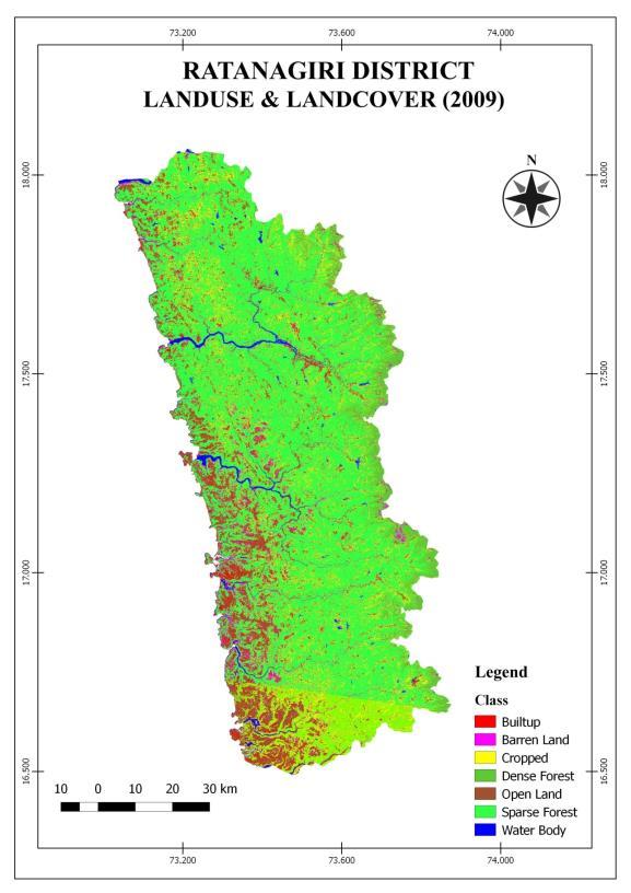
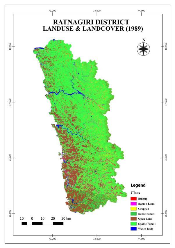
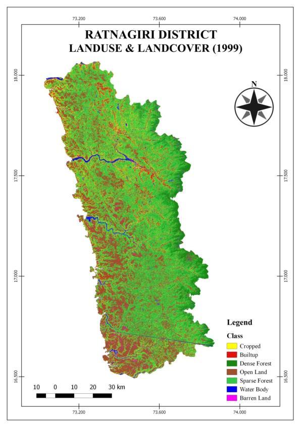
2 Land use refers to the purpose of land reserves, for example, recreation, wildlife habitat or agriculture. Land use applications involve both baseline mapping and subsequent monitoring, since timely information is required to know the current quantity of land and the type of its usage and to identify the land use changes from year to year. Satellite remote sensing data i.e. images and soft data is the most common data source for change detection, quantification, and mapping of LULC patterns and variations can be easily detected due to its repetitive data acquisition, digital format suitable for computer processing, and accurate georeferencing procedures (Anderson, 1976; Chen, Vierling, & Deering, 2005; Jensen, 2005; ). Change detection is the process of identifying differences in the state of an object or phenomenon by observing it at different times. Essentially, it involves the ability to quantify temporal effects using multi-temporal data sets. One of the major applications of remotely-sensed data obtained from Earth-orbiting satellites is change detection because of repetitive coverage at short intervals and consistent image quality (Anderson, 1976). Amount of degradation can be easily accessed using these advances tools and techniques ( Sapkale & Rathod, 2014; 2015). II. Data And Methods Land use and land cover classification through supervised classification methods by using LANDSAT, TM, Satellite image of Ratnagiri Coastal Resource for the years 1989 has been performed/ done. LANDSAT, ETM, Satellite image of Ratnagiri Coastal Resource 1999 and LISS-III Satellite image of Ratnagiri Coastal Resource 2009 were also used to carry out change detection analysis. Satellite images of the years 1989, 1999 and 2009 have been obtained from Global Land Cover Facility (GLCF) & NRSC. The resolution was 30 meters for Landsat data and 23.5 m. LISS III image. During analysis 4-5% error occurs due to variation in the resolution of the images. The Land Use/ Land Cover classification has been performed through supervised classification method using Digital Image Processing software. Erdas Imagine and ArcGIS software are powerful tools for extracting the land use and land cover layers from Ratnagiri Coastal Resource. III. Discussions And Results LAND USE / LAND COVER MAPPING AND CHANGE ANALYSIS: The land use and land cover classes includes agricultural land, forest/vegetation, built up area, water bodies and fallow land. It is the broad classification of the land use and land cover of study area. Table No. 1 LAND USE / LAND COVER CLASSIFICATION IMAGE-YEAR-1989 Sr. No Class Name Area in (Approx) Area in Percentage% 1 Built-up Cropped Open land Dense forest Sparse forest/trees Water body Barren land Total Area CROPPED AREA: The cropped land may be defined broadly as land that is used primarily for production of food and fodder. Cropped land occupies sizeable area. Rice, Vegetables are the major crops in this region. In the year 1989 the cropped land is covered by 7.21% of the total area under these categories. In 1999 about 11.65% of the total area is under cropped in the region. In 2009 about 13.47% of the total area is under cropped. In Ratnagiri district the cropped area has increased by 1.82% in 20 years from 1989 to There is a positive change in agricultural land in these 20 years (table no. 1 to 5). BUILTUP AREA :The built-up land cover is reported from Ratnagiri district in the year of 1989 is 0.10%. The total area covered by built-up land in the years 1999 and 2009 is 0.59% and 2.46% respectively. It can be observed that in these 20 years, from 1989 to 2009 the built-up area has increased by 1.87%. There is a positive change in built-up land in these 20 years. It has also seen that an analytical result for built-up area in the district gives the lower values, because most of the region is occupied by undulating topography, the settlements in the village areas have covered by large size trees-probably mango trees. DOI: / Page

3 Source:- Based on Global Land Cover Facility (GLCF) DOI: / Page
4 DOI: / Page
5 Table No. 2 LAND USE / LAND COVER CLASSIFICATION IMAGE-YEAR-1999 Sr. No Class Name Area in Area in Percentage% 1 Builtup Cropped Open land Dense forest Sparse forest/trees Water body Barren land Total Area Table No. 3 LAND USE / LAND COVER CLASSIFICATION IMAGE-YEAR-2009 Sr. No Class Name Area in Area in Percentage% 1 Builtup Cropped Open land Dense forest Sparse forest/trees Water body Barren land Total Area OPEN LAND AREA : In the Ratnagiri district some area covered with open land. The open land refers to the land, may be uncultivated and unused land. In the year 1989, the open land has occupied 22.92% of total area of region. From 1999 to 2009, it is 22.92% and 11.17% respectively. In Ratnagiri district the open land area has decreased by % in 20 years from 1989 to There is a negative change in open land area in these 20 years. DENSE FOREST AREA : The area under forest includes the land classified as forest under any legal enactment dealing with forest or administrated for forest, whether state-owned or private, and whether wooded or maintained as potential forest land. The areas where crops are raised in the forests and grazing lands or areas open for grazing within the forests are included under forest area (National Commission on Agriculture, 1976). The present Ratnagiri district is located in coastal and hilly region with uneven topography covered by dense vegetation. Most of the area is under dense forests. Table No. 4 LAND USE/ LAND COVER CHANGE FROM 1989 TO 1999 Year-1989 Year-1999 Difference Change (1989 to 1999) Sr. Class Name Area in Area in % Area in Area in % Area in Area in % No 1 Builtup Cropped Open land Dense forest Sparse forest* Water body Barren land Total Area * Scattered trees with different species and bushes/shrubs are included. DOI: / Page
6 Table No. 5 LAND USE/ LAND COVER CHANGE FROM 1999 TO 2009 Year-1999 Year-2009 Difference Change (1999 to 2009) Sr. Class Name Area in Area in % Area in Area in Area in Area in % No % 1 Builtup Cropped Open land Dense forest Sparse forest Water body Barren land Total Area In 1989, the dense forest area was 3.22% of the total area in study region. In 1999 and 2009 the area of Ratnagiri district under dense forest area was 8.22% and 6.23% respectively. It can be observed that in these 20 years, almost 1.99% dense forest area cover has decreased in the study region. There is a negative change in dense forest area in two decades. SPARSE FOREST AREA: The Ratnagiri district is located in coastal and hilly region with uneven topography covered by sparse vegetation. Most of the area is under sparse forests with scattered trees of different species like mango and coconut, also accounted with bushes and shrubs. In 1989, the sparse forests cover was 63.52% of the total area in the study region. In 1999 and 2009 the area of Ratnagiri district under sparse forests was 53.13% and 62.13% respectively. It is observed that in these 20 years, almost 9.00% sparse forests area cover has increased in the study region. There is a positive change in sparse forests area cover in last two decades. Mango plantations on the slope of the hills are also one of the reasons for increasing the area of this category. WATER BODY: Water bodies include estuary, wells, lakes, ponds, river and stream. The percentage of water bodies in the region is 2.08% of the total area in the year The total area covered by water bodies in the years 1999 and 2009 was 1.58% and 1.50% respectively. The area under water bodies in Ratnagiri district has decreased from 1989 to 2009 by -0.08%. BARREN LAND: The Barren land is reported 3.57% in the year The total area covered by barren land in the years 1999 and 2009 is 1.87% and 3.01% respectively. In Ratnagiri district the area under barren land has increased by 1.14% in 20 years i.e. from 1989 to There is a positive change in barren land area in these 20 years. IV. Conclusion Updated information about land use and land cover of the present study area will help to overcome the problems in connection with the agricultural systems, forest cover, various infrastructures etc. Therefore it has suggested that, Remote sensing, GIS, GPS techniques should be used continuously for the management and development in the study area. The analytical results of the present research work, using TM and LISS III images have provided the major categories of the Land use and land cover of Ratnagiri district, still with reducing the errors, micro level study with analyzing sub categories of LULC may be suggested for accurate results. References [1] Anderson, James Richard. A land use and land cover classification system for use with remote sensor data. Vol US Government Printing Office, [2] Chen, X., Vierling, L., & Deering, D., A simple and effective radiometric correction method to improve landscape change detection across sensors and across time. Remote Sensing of Environment, 98(1), 63-79, [3] Jensen, J. R. (2005). Introductory digital image processing: A remote sensing perspective (3rd Edn). Upper Saddle River, NJ: Prentice-Hall, [4] Lillesand, M. T., KIefer, W. R. and Chipman, N, J. (2008). : Remote sensing and image interpretation (6th ed). John Wiley and Sons, Inc, New York.. [5] Rathod, B.L, (2015), Coastal Resource Management Using Remote Sensing and GIS Techniques: A Case Study of Ratnagiri District, Maharashtra, (2015), Unpublished Ph.D. Dissertation. [6] Rathod, B. L., Sapkale, J.B., Status of Agriculture in Coastal Villages of Ratnagiri, Maharashtra.,.,International Journal of Scientific and Engineering Research, (IJSER), 6(9), [7] Sapkale, J.B., Rathod, B. L., Kharlands-An Agrarian Disaster in Coastal Areas of Southern Ratnagiri, Maharashtra: A Study Using Remote Sensing and GIS, International Refereed Journal of Engineering and Science (IRJES), 3(6), 71-78, [8] Socio-economic Review and Statistical Abstract Ratnagiri District [9] Wilkie, D.S. and Finn, J.T. : Remote Sensing Imagery for Natural Resources Monitoring. Columbia University Press, New York., P.P DOI: / Page
Remote Sensing and GIS Application in Change Detection Study Using Multi Temporal Satellite
 Cloud Publications International Journal of Advanced Remote Sensing and GIS 2013, Volume 2, Issue 1, pp. 374-378, Article ID Tech-181 ISSN 2320-0243 Case Study Open Access Remote Sensing and GIS Application
Abstract: About the Author:
 REMOTE SENSING AND GIS IN LAND USE PLANNING Sathees kumar P 1, Nisha Radhakrishnan 2 1 1 Ph.D Research Scholar, Department of Civil Engineering, National Institute of Technology, Tiruchirappalli- 620015,
INTERNATIONAL JOURNAL OF GEOMATICS AND GEOSCIENCES Volume 2, No 1, 2011
 INTERNATIONAL JOURNAL OF GEOMATICS AND GEOSCIENCES Volume 2, No 1, 2011 Copyright 2010 All rights reserved Integrated Publishing services Research article ISSN 0976 4380 Spatio-Temporal changes of Land
Accuracy Assessment of Land Cover Classification in Jodhpur City Using Remote Sensing and GIS
 Accuracy Assessment of Land Cover Classification in Jodhpur City Using Remote Sensing and GIS S.L. Borana 1, S.K.Yadav 1 Scientist, RSG, DL, Jodhpur, Rajasthan, India 1 Abstract: A This study examines
Analysis of Land Use And Land Cover Changes Using Gis, Rs And Determination of Deforestation Factors Using Unsupervised Classification And Clustering
 IOSR Journal of Applied Geology and Geophysics (IOSR-JAGG) e-issn: 2321 0990, p-issn: 2321 0982.Volume 5, Issue 3 Ver. II (May - June 2017), PP 73-78 www.iosrjournals.org Analysis of Land Use And Land
Abstract. TECHNOFAME- A Journal of Multidisciplinary Advance Research. Vol.2 No. 2, (2013) Received: Feb.2013; Accepted Oct.
 Received: Feb.2013; Accepted Oct.") Vol.2 No. 2, 83-87 (2013) Received: Feb.2013; Accepted Oct. 2013 Landuse Pattern Analysis Using Remote Sensing: A Case Study of Morar Block, of Gwalior District, M.P. Subhash Thakur 1 Akhilesh Singh 2
Vol.2 No. 2, 83-87 (2013) Received: Feb.2013; Accepted Oct. 2013 Landuse Pattern Analysis Using Remote Sensing: A Case Study of Morar Block, of Gwalior District, M.P. Subhash Thakur 1 Akhilesh Singh 2
Land Use/Land Cover Mapping in and around South Chennai Using Remote Sensing and GIS Techniques ABSTRACT
 Land Use/Land Cover Mapping in and around South Chennai Using Remote Sensing and GIS Techniques *K. Ilayaraja, Abhishek Singh, Dhiraj Jha, Kriezo Kiso, Amson Bharath institute of Science and Technology
Monitoring of Forest Cover Change in Sundarban mangrove forest using Remote sensing and GIS
 Monitoring of Forest Cover Change in Sundarban mangrove forest using Remote sensing and GIS By Mohammed Monirul Alam April 2008 Content 1: INTRODUCTION 2: OBJECTIVES 3: METHODOLOGY 4: RESULTS & DISCUSSION
Landuse/Landcover Change Detection in Umshing- Mawkynroh of East Khasi Hills District, Meghalaya Using Spatial Information Technology
 International Journal of Scientific and Research Publications, Volume 6, Issue 1, January 2016 197 Landuse/Landcover Change Detection in Umshing- Mawkynroh of East Khasi Hills District, Meghalaya Using
Geospatial Information for Urban Sprawl Planning and Policies Implementation in Developing Country s NCR Region: A Study of NOIDA City, India
 Geospatial Information for Urban Sprawl Planning and Policies Implementation in Developing Country s NCR Region: A Study of NOIDA City, India Dr. Madan Mohan Assistant Professor & Principal Investigator,
Monitoring and Temporal Study of Mining Area of Jodhpur City Using Remote Sensing and GIS
 Monitoring and Temporal Study of Mining Area of Jodhpur City Using Remote Sensing and GIS S. K Yadav 1, S. L Borana 2 1,2 Scientist, Remote Sensing Group, DL, Jodhpur-342011, Rajasthan, India ---------------------------------------------------------------------***---------------------------------------------------------------------
The Study of Impact of Urbanization on Urban Heat Island with Temperature Variation Analysis of MODIS Data Using Remote Sensing and GIS Technology
 Cloud Publications International Journal of Advanced Remote Sensing and GIS 2015, Volume 4, Issue 1, pp. 944-952, Article ID Tech-269 ISSN 2320-0243 Research Article Open Access The Study of Impact of
International Journal of Intellectual Advancements and Research in Engineering Computations
 ISSN:2348-2079 Volume-5 Issue-2 International Journal of Intellectual Advancements and Research in Engineering Computations Agricultural land investigation and change detection in Coimbatore district by
Landuse and Landcover change analysis in Selaiyur village, Tambaram taluk, Chennai
 Landuse and Landcover change analysis in Selaiyur village, Tambaram taluk, Chennai K. Ilayaraja Department of Civil Engineering BIST, Bharath University Selaiyur, Chennai 73 ABSTRACT The synoptic picture
Chitra Sood, R.M. Bhagat and Vaibhav Kalia Centre for Geo-informatics Research and Training, CSK HPKV, Palampur , HP, India
 APPLICATION OF SPACE TECHNOLOGY AND GIS FOR INVENTORYING, MONITORING & CONSERVATION OF MOUNTAIN BIODIVERSITY WITH SPECIAL REFERENCE TO MEDICINAL PLANTS Chitra Sood, R.M. Bhagat and Vaibhav Kalia Centre
7.1 INTRODUCTION 7.2 OBJECTIVE
 7 LAND USE AND LAND COVER 7.1 INTRODUCTION The knowledge of land use and land cover is important for many planning and management activities as it is considered as an essential element for modeling and
Environmental Impact Assessment Land Use and Land Cover CISMHE 7.1 INTRODUCTION
 7 LAND USE AND LAND COVER 7.1 INTRODUCTION The knowledge of land use and land cover is important for many planning and management activities as it is considered an essential element for modeling and understanding
Study of Land Use and Land Cover of Chaksu block, Jaipur through Remote Sensing and GIS
 Study of Land Use and Land Cover of Chaksu block, Jaipur through Remote Sensing and GIS Ruchi Middha *, Sonal Jain* and Shelja K.Juneja ** *RESEARCH SCHOLAR, ENVIRONMENTAL SCIENCE, THE IIS UNIVERSITY,
Change Detection of Land-use and Land-cover of Shirpur Tehsil: A Spatio-Temporal Analysis Yogesh Mahajan 1, Bharat Patil 2, Sanjay Patil 3
 American International Journal of Research in Science, Technology, Engineering & Mathematics Available online at http://www.iasir.net ISSN (Print): 2328-3491, ISSN (Online): 2328-3580, ISSN (CD-ROM): 2328-3629
AGRY 545/ASM 591R. Remote Sensing of Land Resources. Fall Semester Course Syllabus
 AGRY 545/ASM 591R Remote Sensing of Land Resources Fall Semester 2005 Course Syllabus Agronomy 545/ASM 591R is a graduate level course designed to teach students how to analyze and interpret remotely sensed
1. Introduction. Chaithanya, V.V. 1, Binoy, B.V. 2, Vinod, T.R. 2. Publication Date: 8 April DOI: https://doi.org/ /cloud.ijarsg.
 Cloud Publications International Journal of Advanced Remote Sensing and GIS 2017, Volume 6, Issue 1, pp. 2088-2096 ISSN 2320 0243, Crossref: 10.23953/cloud.ijarsg.112 Research Article Open Access Estimation
MAPPING LAND USE/ LAND COVER OF WEST GODAVARI DISTRICT USING NDVI TECHNIQUES AND GIS Anusha. B 1, Sridhar. P 2
 MAPPING LAND USE/ LAND COVER OF WEST GODAVARI DISTRICT USING NDVI TECHNIQUES AND GIS Anusha. B 1, Sridhar. P 2 1 M. Tech. Student, Department of Geoinformatics, SVECW, Bhimavaram, A.P, India 2 Assistant
CHANGES IN VIJAYAWADA CITY BY REMOTE SENSING AND GIS
 International Journal of Civil Engineering and Technology (IJCIET) Volume 8, Issue 5, May 2017, pp.217 223, Article ID: IJCIET_08_05_025 Available online at http://www.ia aeme.com/ijciet/issues.asp?jtype=ijciet&vtyp
Spatio-Temporal changes of Land use/land cover of Pindrangi Village Using High Resolution Satellite Imagery
 IOSR Journal of Applied Geology and Geophysics (IOSR-JAGG) e-issn: 2321 0990, p-issn: 2321 0982.Volume 5, Issue 4 Ver. II (Jul. Aug. 2017), PP 40-44 www.iosrjournals.org Spatio-Temporal changes of Land
INTERNATIONAL JOURNAL OF GEOMATICS AND GEOSCIENCES Volume 4, No 2, 2013
 INTERNATIONAL JOURNAL OF GEOMATICS AND GEOSCIENCES Volume 4, No 2, 2013 Copyright 2010 All rights reserved Integrated Publishing services Research article ISSN 0976 4380 Evaluation of landuse / landcover
Use of Corona, Landsat TM, Spot 5 images to assess 40 years of land use/cover changes in Cavusbasi
 New Strategies for European Remote Sensing, Olui (ed.) 2005 Millpress, Rotterdam, ISBN 90 5966 003 X Use of Corona, Landsat TM, Spot 5 images to assess 40 years of land use/cover changes in Cavusbasi N.
Quantifying Land Use/Cover Dynamics of Nainital Town (India) Using Remote Sensing and GIS Techniques
 Using Remote Sensing and GIS Techniques") Quantifying Land Use/Cover Dynamics of Nainital Town (India) Using Remote Sensing and GIS Techniques Jiwan Rawat 1*, Vivekananda Biswas 1 and Manish Kumar 1 1 Centre of Excellence for NRDMS in Uttarakhand,
Quantifying Land Use/Cover Dynamics of Nainital Town (India) Using Remote Sensing and GIS Techniques Jiwan Rawat 1*, Vivekananda Biswas 1 and Manish Kumar 1 1 Centre of Excellence for NRDMS in Uttarakhand,
LAND CAPABILITY CLASSIFICATION FOR INTEGRATED WATERSHED DEVELOPMENT BY APPLYING REMOTE SENSING AND GIS TECHNIQUES
 LAND CAPABILITY CLASSIFICATION FOR INTEGRATED WATERSHED DEVELOPMENT BY APPLYING REMOTE SENSING AND GIS TECHNIQUES Sachin Panhalkar Department of Geography, Shivaji University, Kolhapur, Maharashtra, India
Identification of Land use and Land cover Changes using Remote Sensing and GIS
 Identification of Land use and Land cover Changes using Remote Sensing and GIS N. Nagarajan and. S. Poongothai Abstract This study reveals to identify the changes of land use/land cover of rural agricultural
Urban Expansion and Loss of Agricultural Land: A Remote Sensing Based Study of Shirpur City, Maharashtra
 Cloud Publications International Journal of Advanced Remote Sensing and GIS 2017, Volume 6, Issue 1, pp. 2097-2102 ISSN 2320 0243, Crossref: 10.23953/cloud.ijarsg.113 Research Article Open Access Urban
IMAGE CLASSIFICATION TOOL FOR LAND USE / LAND COVER ANALYSIS: A COMPARATIVE STUDY OF MAXIMUM LIKELIHOOD AND MINIMUM DISTANCE METHOD
 IMAGE CLASSIFICATION TOOL FOR LAND USE / LAND COVER ANALYSIS: A COMPARATIVE STUDY OF MAXIMUM LIKELIHOOD AND MINIMUM DISTANCE METHOD Manisha B. Patil 1, Chitra G. Desai 2 and * Bhavana N. Umrikar 3 1 Department
LAND USE AND LAND COVER ANALYSIS USING 8- BAND DATA: A CASE STUDY OF BELGAUM CITY AND ITS SURROUNDING.
 LAND USE AND LAND COVER ANALYSIS USING 8- BAND DATA: A CASE STUDY OF BELGAUM CITY AND ITS SURROUNDING. Mrs. Rita Basanna *, Dr. A.K. Wodeyar ** ABSTRACT Monitoring land-use change has become an important
INTERNATIONAL JOURNAL OF GEOMATICS AND GEOSCIENCES Volume 6, No 2, 2015
 INTERNATIONAL JOURNAL OF GEOMATICS AND GEOSCIENCES Volume 6, No 2, 2015 Copyright by the authors - Licensee IPA- Under Creative Commons license 3.0 Research article ISSN 0976 4380 An Analysis of Land use
Critical Assessment of Land Use Land Cover Dynamics Using Multi-Temporal Satellite Images
 Environments 2015, 2, 61-90; doi:10.3390/environments2010061 OPEN ACCESS environments ISSN 2076-3298 www.mdpi.com/journal/environments Article Critical Assessment of Land Use Land Cover Dynamics Using
Spatiotemporal Analysis of Noida, Greater Noida and Surrounding Areas (India) Using Remote Sensing and GIS Approaches
 Using Remote Sensing and GIS Approaches") Spatiotemporal Analysis of Noida, Greater Noida and Surrounding Areas (India) Using Remote Sensing and GIS Approaches Gopal Krishna* Indian Agricultural Research Institute, New Delhi, India ABSTRACT Spatiotemporal
Spatiotemporal Analysis of Noida, Greater Noida and Surrounding Areas (India) Using Remote Sensing and GIS Approaches Gopal Krishna* Indian Agricultural Research Institute, New Delhi, India ABSTRACT Spatiotemporal
International Journal of Scientific Research and Reviews
 Case Study Available online www.ijsrr.org ISSN: 2279 0543 International Journal of Scientific Research and Reviews Study on the Pattern of Land Use /Land Cover Change in Sonipat District of NCR, A Block
INTERNATIONAL JOURNAL OF GEOMATICS AND GEOSCIENCES Volume 4, No 4, 2014
 INTERNATIONAL JOURNAL OF GEOMATICS AND GEOSCIENCES Volume 4, No 4, 2014 Copyright 2010 All rights reserved Integrated Publishing services Research article ISSN 0976 4380 Assessment of spatio-temporal variations
Monitoring Vegetation Growth of Spectrally Landsat Satellite Imagery ETM+ 7 & TM 5 for Western Region of Iraq by Using Remote Sensing Techniques.
 Monitoring Vegetation Growth of Spectrally Landsat Satellite Imagery ETM+ 7 & TM 5 for Western Region of Iraq by Using Remote Sensing Techniques. Fouad K. Mashee, Ahmed A. Zaeen & Gheidaa S. Hadi Remote
URBAN CHANGE DETECTION OF LAHORE (PAKISTAN) USING A TIME SERIES OF SATELLITE IMAGES SINCE 1972
 USING A TIME SERIES OF SATELLITE IMAGES SINCE 1972") URBAN CHANGE DETECTION OF LAHORE (PAKISTAN) USING A TIME SERIES OF SATELLITE IMAGES SINCE 1972 Omar Riaz Department of Earth Sciences, University of Sargodha, Sargodha, PAKISTAN. omarriazpk@gmail.com ABSTRACT
URBAN CHANGE DETECTION OF LAHORE (PAKISTAN) USING A TIME SERIES OF SATELLITE IMAGES SINCE 1972 Omar Riaz Department of Earth Sciences, University of Sargodha, Sargodha, PAKISTAN. omarriazpk@gmail.com ABSTRACT
GROUNDWATER CONFIGURATION IN THE UPPER CATCHMENT OF MEGHADRIGEDDA RESERVOIR, VISAKHAPATNAM DISTRICT, ANDHRA PRADESH
 GROUNDWATER CONFIGURATION IN THE UPPER CATCHMENT OF MEGHADRIGEDDA RESERVOIR, VISAKHAPATNAM DISTRICT, ANDHRA PRADESH Prof.P.Jagadeesara Rao Department of Geo-Engineering and Centre for Remote Sensing, College
Comparison of MLC and FCM Techniques with Satellite Imagery in A Part of Narmada River Basin of Madhya Pradesh, India
 Cloud Publications International Journal of Advanced Remote Sensing and GIS 013, Volume, Issue 1, pp. 130-137, Article ID Tech-96 ISS 30-043 Research Article Open Access Comparison of MLC and FCM Techniques
A Small Migrating Herd. Mapping Wildlife Distribution 1. Mapping Wildlife Distribution 2. Conservation & Reserve Management
 A Basic Introduction to Wildlife Mapping & Modeling ~~~~~~~~~~ Rev. Ronald J. Wasowski, C.S.C. Associate Professor of Environmental Science University of Portland Portland, Oregon 8 December 2015 Introduction
Effect of land use/land cover changes on runoff in a river basin: a case study
 Water Resources Management VI 139 Effect of land use/land cover changes on runoff in a river basin: a case study J. Letha, B. Thulasidharan Nair & B. Amruth Chand College of Engineering, Trivandrum, Kerala,
American International Journal of Research in Humanities, Arts and Social Sciences
 American International Journal of Research in Humanities, Arts and Social Sciences Available online at http://www.iasir.net ISSN (Print): 2328-3734, ISSN (Online): 2328-3696, ISSN (CD-ROM): 2328-3688 AIJRHASS
Impact of Dam and Weirs on Cross-Sectional Characteristics of Urmodi Channel, Maharashtra: An Approach to Geoinformatics
 Impact of Dam and Weirs on Cross-Sectional Characteristics of Urmodi Channel, Maharashtra: An Approach to Geoinformatics Sarika B. Suryawanshi, Jagdish B. Sapkale, Vidya A. Chougule Abstract Dams and reservoirs
Geospatial technology for land cover analysis
 Home Articles Application Environment & Climate Conservation & monitoring Published in : Middle East & Africa Geospatial Digest November 2013 Lemenkova Polina Charles University in Prague, Faculty of Science,
HIGH RESOLUTION SATELLITE DATA FOR LAND USE/LAND COVER MAPPING IN ROHTAK DISTRICT HARYANA, INDIA
 HIGH RESOLUTION SATELLITE DATA FOR LAND USE/LAND COVER MAPPING IN ROHTAK DISTRICT HARYANA, INDIA MR. MUKESH KUMAR 1 AND MR.SANDEEP KUMAR 2 1. M.tech. Student, Department of Geography, M.D.University Rohtak,
APPLICATION OF LAND CHANGE MODELER FOR PREDICTION OF FUTURE LAND USE LAND COVER A CASE STUDY OF VIJAYAWADA CITY
 APPLICATION OF LAND CHANGE MODELER FOR PREDICTION OF FUTURE LAND USE LAND COVER A CASE STUDY OF VIJAYAWADA CITY K. Sundara Kumar 1, Dr. P. Udaya Bhaskar 2, Dr. K. Padmakumari 3 1 Research Scholar, 2,3
Detection of Land Use and Land Cover Change around Eti-Osa Coastal Zone, Lagos State, Nigeria using Remote Sensing and GIS
 International Research Journal of Environment Sciences E-ISSN 2319 1414 Detection of Land Use and Land Cover Change around Eti-Osa Coastal Zone, Lagos State, Nigeria using Remote Sensing and GIS Abstract
CHANGE DETECTION USING REMOTE SENSING- LAND COVER CHANGE ANALYSIS OF THE TEBA CATCHMENT IN SPAIN (A CASE STUDY)
") CHANGE DETECTION USING REMOTE SENSING- LAND COVER CHANGE ANALYSIS OF THE TEBA CATCHMENT IN SPAIN (A CASE STUDY) Sharda Singh, Professor & Programme Director CENTRE FOR GEO-INFORMATICS RESEARCH AND TRAINING
CHANGE DETECTION USING REMOTE SENSING- LAND COVER CHANGE ANALYSIS OF THE TEBA CATCHMENT IN SPAIN (A CASE STUDY) Sharda Singh, Professor & Programme Director CENTRE FOR GEO-INFORMATICS RESEARCH AND TRAINING
Dr. S.SURIYA. Assistant professor. Department of Civil Engineering. B. S. Abdur Rahman University. Chennai
 Hydrograph simulation for a rural watershed using SCS curve number and Geographic Information System Dr. S.SURIYA Assistant professor Department of Civil Engineering B. S. Abdur Rahman University Chennai
International Journal of Modern Trends in Engineering and Research e-issn No.: , Date: April, 2016
 International Journal of Modern Trends in Engineering and Research www.ijmter.com e-issn No.:2349-9745, Date: 28-30 April, 2016 Landslide Hazard Management Maps for Settlements in Yelwandi River Basin,
STUDY OF NORMALIZED DIFFERENCE BUILT-UP (NDBI) INDEX IN AUTOMATICALLY MAPPING URBAN AREAS FROM LANDSAT TM IMAGERY
 INDEX IN AUTOMATICALLY MAPPING URBAN AREAS FROM LANDSAT TM IMAGERY") STUDY OF NORMALIZED DIFFERENCE BUILT-UP (NDBI) INDEX IN AUTOMATICALLY MAPPING URBAN AREAS FROM LANDSAT TM IMAGERY Dr. Hari Krishna Karanam Professor, Civil Engineering, Dadi Institute of Engineering &
STUDY OF NORMALIZED DIFFERENCE BUILT-UP (NDBI) INDEX IN AUTOMATICALLY MAPPING URBAN AREAS FROM LANDSAT TM IMAGERY Dr. Hari Krishna Karanam Professor, Civil Engineering, Dadi Institute of Engineering &
Accuracy Assessment of Land Use & Land Cover Classification (LU/LC) Case study of Shomadi area- Renk County-Upper Nile State, South Sudan
 Case study of Shomadi area- Renk County-Upper Nile State, South Sudan") International Journal of Scientific and Research Publications, Volume 3, Issue 5, May 2013 1 Accuracy Assessment of Land Use & Land Cover Classification (LU/LC) Case study of Shomadi area- Renk County-Upper
International Journal of Scientific and Research Publications, Volume 3, Issue 5, May 2013 1 Accuracy Assessment of Land Use & Land Cover Classification (LU/LC) Case study of Shomadi area- Renk County-Upper
VEGETATION ANALYSIS AND LAND USE LAND COVER CLASSIFICATION OF FOREST IN UTTARA KANNADA DISTRICT INDIA USING REMOTE SENSIGN AND GIS TECHNIQUES
 VEGETATION ANALYSIS AND LAND USE LAND COVER CLASSIFICATION OF FOREST IN UTTARA KANNADA DISTRICT INDIA USING REMOTE SENSIGN AND GIS TECHNIQUES A.G. Koppad a, B S Janagoudar b a Professor and Head (NRM),
Progress and Land-Use Characteristics of Urban Sprawl in Busan Metropolitan City using Remote sensing and GIS
 Progress and Land-Use Characteristics of Urban Sprawl in Busan Metropolitan City using Remote sensing and GIS Homyung Park, Taekyung Baek, Yongeun Shin, Hungkwan Kim ABSTRACT Satellite image is very usefully
RESEARCH METHODOLOGY
 III. RESEARCH METHODOLOGY 3.1. Time and Research Area The field work was taken place in primary forest around Toro village in Lore Lindu National Park, Indonesia. The study area located in 120 o 2 53 120
Investigation of the Effect of Transportation Network on Urban Growth by Using Satellite Images and Geographic Information Systems
 Presented at the FIG Congress 2018, May 6-11, 2018 in Istanbul, Turkey Investigation of the Effect of Transportation Network on Urban Growth by Using Satellite Images and Geographic Information Systems
VILLAGE INFORMATION SYSTEM (V.I.S) FOR WATERSHED MANAGEMENT IN THE NORTH AHMADNAGAR DISTRICT, MAHARASHTRA
 FOR WATERSHED MANAGEMENT IN THE NORTH AHMADNAGAR DISTRICT, MAHARASHTRA") VILLAGE INFORMATION SYSTEM (V.I.S) FOR WATERSHED MANAGEMENT IN THE NORTH AHMADNAGAR DISTRICT, MAHARASHTRA Abstract: The drought prone zone in the Western Maharashtra is not in position to achieve the agricultural
VILLAGE INFORMATION SYSTEM (V.I.S) FOR WATERSHED MANAGEMENT IN THE NORTH AHMADNAGAR DISTRICT, MAHARASHTRA Abstract: The drought prone zone in the Western Maharashtra is not in position to achieve the agricultural
THE REVISION OF 1:50000 TOPOGRAPHIC MAP OF ONITSHA METROPOLIS, ANAMBRA STATE, NIGERIA USING NIGERIASAT-1 IMAGERY
 I.J.E.M.S., VOL.5 (4) 2014: 235-240 ISSN 2229-600X THE REVISION OF 1:50000 TOPOGRAPHIC MAP OF ONITSHA METROPOLIS, ANAMBRA STATE, NIGERIA USING NIGERIASAT-1 IMAGERY 1* Ejikeme, J.O. 1 Igbokwe, J.I. 1 Igbokwe,
Summary Description Municipality of Anchorage. Anchorage Coastal Resource Atlas Project
 Summary Description Municipality of Anchorage Anchorage Coastal Resource Atlas Project By: Thede Tobish, MOA Planner; and Charlie Barnwell, MOA GIS Manager Introduction Local governments often struggle
Urban Area Delineation Using Pattern Recognition Technique
 Cloud Publications International Journal of Advanced Remote Sensing and GIS 2018, Volume 7, Issue 1, pp. 2466-2470 ISSN 2320 0243, Crossref: 10.23953/cloud.ijarsg.333 Methodology Article Urban Area Delineation
M.C.PALIWAL. Department of Civil Engineering NATIONAL INSTITUTE OF TECHNICAL TEACHERS TRAINING & RESEARCH, BHOPAL (M.P.), INDIA
, INDIA") INVESTIGATIONS ON THE ACCURACY ASPECTS IN THE LAND USE/LAND COVER MAPPING USING REMOTE SENSING SATELLITE IMAGERY By M.C.PALIWAL Department of Civil Engineering NATIONAL INSTITUTE OF TECHNICAL TEACHERS
INVESTIGATIONS ON THE ACCURACY ASPECTS IN THE LAND USE/LAND COVER MAPPING USING REMOTE SENSING SATELLITE IMAGERY By M.C.PALIWAL Department of Civil Engineering NATIONAL INSTITUTE OF TECHNICAL TEACHERS
VISUALIZATION URBAN SPATIAL GROWTH OF DESERT CITIES FROM SATELLITE IMAGERY: A PRELIMINARY STUDY
 CO-439 VISUALIZATION URBAN SPATIAL GROWTH OF DESERT CITIES FROM SATELLITE IMAGERY: A PRELIMINARY STUDY YANG X. Florida State University, TALLAHASSEE, FLORIDA, UNITED STATES ABSTRACT Desert cities, particularly
Wastelands Analysis and Mapping of Bhiwani District, Haryana
 Wastelands Analysis and Mapping of Bhiwani District, Haryana Virender Sihag Research Scholar, Department of Geography, OPJS University, Churu, Rajasthan ABSTRACT This study aimed at monitoring, mapping,
Overview of Remote Sensing in Natural Resources Mapping
 Overview of Remote Sensing in Natural Resources Mapping What is remote sensing? Why remote sensing? Examples of remote sensing in natural resources mapping Class goals What is Remote Sensing A remote sensing
An Investigation into Land Use and Land Cover Change through Object Based Classification (A Case Study of South Haldwani, Uttarakhand, India)
") International Journal of Humanities and Social Science Invention (IJHSSI) ISSN (Online): 2319 7722, ISSN (Print): 2319 7714 Volume 7 Issue 03 Ver. II March. 2018 PP.50-58 An Investigation into Land Use
International Journal of Humanities and Social Science Invention (IJHSSI) ISSN (Online): 2319 7722, ISSN (Print): 2319 7714 Volume 7 Issue 03 Ver. II March. 2018 PP.50-58 An Investigation into Land Use
LAND USE/LAND COVER CLASSIFICATION AND ACCURACY ASSESSMENT USING SATELLITE DATA - A CASE STUDY OF BHIND DISTRICT, MADHYA PRADESH
 , pp.-422-426. Available online at http://www.bioinfopublication.org/jouarchive.php?opt=&jouid=bpj0000217 LAND USE/LAND COVER CLASSIFICATION AND ACCURACY ASSESSMENT USING SATELLITE DATA - A CASE STUDY
Table 4.1 Images used for the Study. Spatial Resolution (Meter) Resolution (Bits) 30 (For 6th band 120)
 Resolution (Bits) 30 (For 6th band 120)")
Coalfields Limited. Based on Satellite Data for the Year Central Coalfields Limited Ranchi, Jharkhand. Submitted to:
 Land Restoration / Reclamation Monitoring of less than 5 m cu. m. (Coal + OB) Capacity Open Cast Coal Mines of Central Coalfields Limited Based on Satellite Data for the Year 2011. N URIMARI (BIRSA) OCP,CCL
Digital Change Detection Using Remotely Sensed Data for Monitoring Green Space Destruction in Tabriz
 Int. J. Environ. Res. 1 (1): 35-41, Winter 2007 ISSN:1735-6865 Graduate Faculty of Environment University of Tehran Digital Change Detection Using Remotely Sensed Data for Monitoring Green Space Destruction
Landuse Pattern Analysis Using Remote Sensing: A Case Study of Mau District, India
 Available online at www.scholarsresearchlibrary.com Archives of Applied Science Research, 2011, 3 (5):10-16 (http://scholarsresearchlibrary.com/archive.html) ISSN 0975-508X CODEN (USA) AASRC9 Landuse Pattern
PREDICTION OF FUTURE LAND USE LAND COVER CHANGES OF VIJAYAWADA CITY USING REMOTE SENSING AND GIS
 PREDICTION OF FUTURE LAND USE LAND COVER CHANGES OF VIJAYAWADA CITY USING REMOTE SENSING AND GIS K. Sundara Kumar 1 *, N V A Sai Sankar Valasala 2, J V Subrahmanyam V 3, Mounika Mallampati 4 Kowsharajaha
Land Use and Land Cover Detection by Different Classification Systems using Remotely Sensed Data of Kuala Tiga, Tanah Merah Kelantan, Malaysia
 Land Use and Land Cover Detection by Different Classification Systems using Remotely Sensed Data of Kuala Tiga, Tanah Merah Kelantan, Malaysia Wani Sofia Udin*, Zuhaira Nadhila Zahuri Faculty of Earth
We greatly appreciate the review of the manuscript by the anonymous referee#3. We hereby put forth the clarifications as follows.
 Point by point response to the observations & comments of Anonymous Reviewer # 3 on the manuscript titled Seismic Vulnerability & Risk Assessment of Kolkata City, India (ms# nhess-2013-467) We greatly
Change Detection Methods Using Band Ratio and Raster to Vector Transform
 Change Detection Methods Using Band Ratio and Raster to Vector Transform Gheidaa Sabeeh Al-Hassany Remote sensing Unit, College of Science, University of Baghdad, Baghdad, Iraq Gheida2009@yahoo.com Abstract
Submitted to: Central Coalfields Limited Ranchi, Jharkhand. Ashoka & Piparwar OCPs, CCL
 Land Restoration / Reclamation Monitoring of more than 5 million cu. m. (Coal + OB) Capacity Open Cast Coal Mines of Central Coalfields Limited Based on Satellite Data for the Year 2013 Ashoka & Piparwar
Advanced Image Analysis in Disaster Response
 Advanced Image Analysis in Disaster Response Creating Geographic Knowledge Thomas Harris ITT The information contained in this document pertains to software products and services that are subject to the
Thematic Mapping in Siwani Area, District Bhiwani using Remote Sensing and Gis
 International Journal of Research in Geography (IJRG) Volume 3, Issue 2, 2017, PP 12-17 ISSN 2454-8685 (Online) DOI: http://dx.doi.org/10.20431/2454-8685.0302002 www.arcjournals.org Thematic Mapping in
1. Introduction. S.S. Patil 1, Sachidananda 1, U.B. Angadi 2, and D.K. Prabhuraj 3
 Cloud Publications International Journal of Advanced Remote Sensing and GIS 2014, Volume 3, Issue 1, pp. 525-531, Article ID Tech-249 ISSN 2320-0243 Research Article Open Access Machine Learning Technique
Urban Growth Analysis: Calculating Metrics to Quantify Urban Sprawl
 Urban Growth Analysis: Calculating Metrics to Quantify Urban Sprawl Jason Parent jason.parent@uconn.edu Academic Assistant GIS Analyst Daniel Civco Professor of Geomatics Center for Land Use Education
Journal of Asian Scientific Research STUDYING OF THE ENVIRONMENTAL CHANGES IN MARSH AREA USING LANDSAT SATELLITE IMAGES
 Journal of Asian Scientific Research journal homepage: http://aessweb.com/journal-detail.php?id=5003 STUDYING OF THE ENVIRONMENTAL CHANGES IN MARSH AREA USING LANDSAT SATELLITE IMAGES Salah A. H. Saleh
Changing Urban Built-up Area of Sangli-Miraj and Kupwad Municipal Corporation, Maharashtra (India): Using Satellite Data and GIS
: Using Satellite Data and GIS") Changing Urban Built-up Area of Sangli-Miraj and Kupwad Municipal Corporation, Maharashtra (India): Using Satellite Data and GIS Authors & Affiliation: Dr. Pradip Ashok Saymote Assist. Professor, P.G.
Changing Urban Built-up Area of Sangli-Miraj and Kupwad Municipal Corporation, Maharashtra (India): Using Satellite Data and GIS Authors & Affiliation: Dr. Pradip Ashok Saymote Assist. Professor, P.G.
Monitoring and Change Detection along the Eastern Side of Qena Bend, Nile Valley, Egypt Using GIS and Remote Sensing
 Advances in Remote Sensing, 2013, 2, 276-281 http://dx.doi.org/10.4236/ars.2013.23030 Published Online September 2013 (http://www.scirp.org/journal/ars) Monitoring and Change Detection along the Eastern
Coastal Landuse Change Detection Using Remote Sensing Technique: Case Study in Banten Bay, West Java Island, Indonesia
 Kasetsart J. (Nat. Sci.) 39 : 159-164 (2005) Coastal Landuse Change Detection Using Remote Sensing Technique: Case Study in Banten Bay, West Java Island, Indonesia Puvadol Doydee ABSTRACT Various forms
LAND SUITABILITY STUDY IN LAND DEGRADED AREA DUE TO MINING IN DHANBAD DISTRICT, JHARKHAND.
 LAND SUITABILITY STUDY IN LAND DEGRADED AREA DUE TO MINING IN DHANBAD DISTRICT, JHARKHAND. Saranathan, E a*, Loveson, V.J b. and Victor Rajamanickam, G c a School of Civil Engineering, SASTRA, Thanjavur
Yaneev Golombek, GISP. Merrick/McLaughlin. ESRI International User. July 9, Engineering Architecture Design-Build Surveying GeoSpatial Solutions
 Yaneev Golombek, GISP GIS July Presentation 9, 2013 for Merrick/McLaughlin Conference Water ESRI International User July 9, 2013 Engineering Architecture Design-Build Surveying GeoSpatial Solutions Purpose
Modeling Urban Land Cover Growth Dynamics Based on Land Change Modeler (LCM) Using Remote Sensing: A Case Study of Gurgaon, India
 Using Remote Sensing: A Case Study of Gurgaon, India") Advances in Computational Sciences and Technology ISSN 0973-6107 Volume 10, Number 10 (2017) pp. 2947-2961 Research India Publications http://www.ripublication.com Modeling Urban Land Cover Growth Dynamics
Advances in Computational Sciences and Technology ISSN 0973-6107 Volume 10, Number 10 (2017) pp. 2947-2961 Research India Publications http://www.ripublication.com Modeling Urban Land Cover Growth Dynamics
Flood hazard mapping in Urban Council limit, Vavuniya District, Sri Lanka- A GIS approach
 International Research Journal of Environment Sciences E-ISSN 2319 1414 Flood hazard mapping in Urban Council limit, Vavuniya District, Sri Lanka- A GIS approach Abstract M.S.R. Akther* and G. Tharani
Abstract. 1. Introduction. 2. Materials and Methods. 2.1 Study Area
 Land Use and Land Cover Mapping by using Remote Sensing and GIS Techniques a Case Study of Kasaba Hobli, Hoskote Taluk, Bangalore Rural District, Karnataka, India. Prof. Dr. P. K. Srimani, F.N.A.Sc., Prof
Modeling the Change of Mangrove Forests in Irrawaddy Delta, South Myanmar
 International Journal of Sciences: Basic and Applied Research (IJSBAR) ISSN 2307-4531 (Print & Online) http://gssrr.org/index.php?journal=journalofbasicandapplied ---------------------------------------------------------------------------------------------------------------------------
Change Detection Across Geographical System of Land using High Resolution Satellite Imagery
 IJCTA, 9(40), 2016, pp. 129-139 International Science Press Closed Loop Control of Soft Switched Forward Converter Using Intelligent Controller 129 Change Detection Across Geographical System of using
International Journal of Scientific & Engineering Research, Volume 3, Issue 11, November ISSN
 International Journal of Scientific & Engineering Research, Volume 3, Issue 11, November-2012 1 ABSTRACT Land use land cover change detection of Ghatkesar mandal,rangareddy district using Remote sensing
This is trial version
 Journal of Rangeland Science, 2012, Vol. 2, No. 2 J. Barkhordari and T. Vardanian/ 459 Contents available at ISC and SID Journal homepage: www.rangeland.ir Full Paper Article: Using Post-Classification
Multifunctional theory in agricultural land use planning case study
 Multifunctional theory in agricultural land use planning case study Introduction István Ferencsik (PhD) VÁTI Research Department, iferencsik@vati.hu By the end of 20 th century demands and expectations
RESULT. 4.1 Temporal Land use / Land Cover (LULC) inventory and Change Analysis
 inventory and Change Analysis") Chapter 4 RESULTS RESULT 4.1 Temporal Land use / Land Cover (LULC) inventory and Change Analysis The LULC maps of each study period were prepared by digital supervised classification of Landsat TM satellite
Chapter 4 RESULTS RESULT 4.1 Temporal Land use / Land Cover (LULC) inventory and Change Analysis The LULC maps of each study period were prepared by digital supervised classification of Landsat TM satellite
CHAPTER V LAND USE / LAND COVER AND SITE SUITABILITY ANALYSIS
 CHAPTER V LAND USE / LAND COVER AND SITE SUITABILITY ANALYSIS 5.0 Introduction Land use refers to the human activities on land, which are directly related to the land. It encompasses a vide varieties in
Remote Sensing and GIS Techniques for Monitoring Industrial Wastes for Baghdad City
 The 1 st Regional Conference of Eng. Sci. NUCEJ Spatial ISSUE vol.11,no.3, 2008 pp 357-365 Remote Sensing and GIS Techniques for Monitoring Industrial Wastes for Baghdad City Mohammad Ali Al-Hashimi University
Land Use and Land Cover Mapping and Change Detection in Jind District of Haryana Using Multi-Temporal Satellite Data
 Land Use and Land Cover Mapping and Change Detection in Jind District of Haryana Using Multi-Temporal Satellite Data Ravindra Prawasi, M.P. Sharma, T. P. Babu, Om Pal, Saroj, Kirti Yadav, R.S.Hooda Abstract
A NORMALIZED DIFFERENCE VEGETATION INDEX (NDVI) TIME-SERIES OF IDLE AGRICULTURE LANDS: A PRELIMINARY STUDY
 TIME-SERIES OF IDLE AGRICULTURE LANDS: A PRELIMINARY STUDY") A NORMALIZED DIFFERENCE VEGETATION INDEX (NDVI) TIME-SERIES OF IDLE AGRICULTURE LANDS: A PRELIMINARY STUDY Chaichoke Vaiphasa 1*, Supawee Piamduaytham 2, Tanasak Vaiphasa 3, and Andrew K. Skidmore 4 1
A NORMALIZED DIFFERENCE VEGETATION INDEX (NDVI) TIME-SERIES OF IDLE AGRICULTURE LANDS: A PRELIMINARY STUDY Chaichoke Vaiphasa 1*, Supawee Piamduaytham 2, Tanasak Vaiphasa 3, and Andrew K. Skidmore 4 1