Contemporary Data Collection and Spatial Information Management Techniques to support Good Land Policies
|
|
|
- Bennett Gordon
- 5 years ago
- Views:
Transcription
1 Contemporary Data Collection and Spatial Information Management Techniques to support Good Land Policies Ch. Ioannidis Associate Professor FIG Commission 3 Workshop Paris, October 2011
2 Introduction Great volume of data from various sources Automatic techniques for data management Time saving Production of new data Processed spatial information for decision-making / better monitoring of impacts on the environment, the economy and the society Today there is an urgent need for several countries to do reforms and reorganize their infrastructure in order to meet the requirements of the globalized environment and achieve a sustainable prosperity for all
3 The common situation in several countries (e.g., Greece) is: Although there is enough know-how There is a weak administration & inefficient management, and There is an urgent need for adaptation of the administration at all levels The identification of the best use of modern technology and tools is needed for better and in-time decision-making at all levels of government A typical example is the management of informal development: from the right estimation of the size of the problem, the detection/localization, up to the regeneration of the areas and the monitoring to minimize the phenomenon in the future
4 Modern sources of data collection and management of spatial information During the last years new tools have been available and added to the traditional data collection sources: Positioning systems LIDAR systems High resolution satellite optical images resolution 0.5m, direct georeferencing, rigorous georeferencing models SAR images active microwave imaging sensor, side-looking geometry, 1m resolution Combined use: advantages, variety of applications

5 SAR geometry SAR image is distorted both geometrically and radiometrically, through foreshortening, range and azimuth shift, layover, radiometric modulation associated with slope, shadowing SAR Imaging geometry in range
 Radargrammetry")
6 Methods for SAR processing Interferometry (InSAR / IfSAR) Radargrammetry Polarimetry
 single image method Multi-polarimetric SAR SAR")
 image two SAR images two or four SAR")
7 DSM extraction from SAR images SAR clinometry (shape from shading) single image method Multi-polarimetric SAR SAR interferometry (InSAR) Stereo-radargrammetry single (multi-polarimetric) image two SAR images two or four SAR images


8 Combined use of SAR & optical images SAR image Fused image in slant range geometry
9 Simple techniques Crowd-sourcing for the collection of both qualitative & quantitative information New instruments and tools: - Maps on the internet - PDAs, cell-phones - Web-GIS / Distributed systems - Development of Positioning systems GPS / Glonass / Compass / Galileo High accuracy using cheep & user-friendly handheld instruments
10 Automatic techniques for processing Object extraction Building detection Change detection in urban environment (building scale) Change detection techniques Small scale (e.g. informal settlements) Large scale (e.g. informal buildings) Low level Mid level High level Mathematical morphology Active contour or snakes Neural networks Knowledge based systems
11 Change detection approaches Pixel values Features Knowledge Low level Mid level High level Change detection
12 Commercial change detection software e-cognition, Defiens object oriented classification image segmentation a priori knowledge fuzzy logic Feature Analyst, Visual Learning Systems Inc. machine learning training, correction, iteration Custom made - case dependent - accurate
13 Problem: i.e. the management of the informal settlements (Greece) The main causes for the creation of informal development during the last decades are: Lack of spatial planning policy Lack of cadastre Bureaucracy corruption Difficulty to locate quickly the under construction informal buildings in a cost-effective way

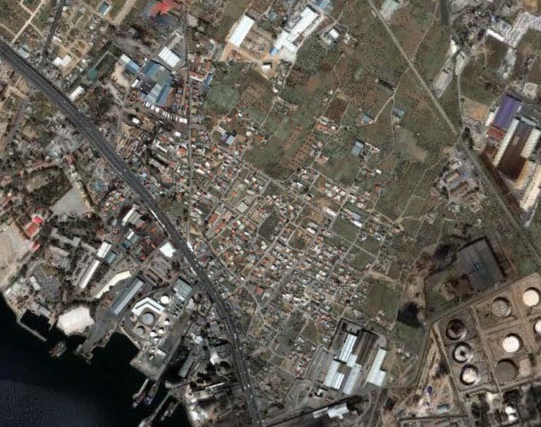
14 Areas with informal constructions
15 Identification of the Problem It is a complicated situation that needs to be solved for a number of reasons: social impact, environmental impact, and administrative and economic impact Need for special legislation and land-use regulations Lack of reliable statistical data means inability to estimate the size of the problem and the size of its impacts. However, that way we may adopt the wrong policies. Result: bad for the prosperity of the people and bad for the national economy We need to make the best use in terms of time and cost saving of the available sources for spatial data collection Contribution of modern techniques and tools for the design of an automated and objective procedure for the detection of informal constructions
16 Spatial data collection and creation of the needed spatial data infrastructure Use of existing information Cadastral maps Orthophotomaps National-wide DSM / DTM Urban plans Forest maps / Coastal maps GIS applications... Complementary use of other means Low cost techniques Contemporary data sources and tools (satellite images & LIDAR)
17 Best use of the available information in support of good Land Policy Reliable estimation of the size of the problem (total number of informal buildings, and estimation of the impacts) Tools to support and speed up the declaration procedure Detection of the non-declared informal buildings Management of the collected information through the declarations Support the regeneration projects and infrastructure improvements in the areas Monitoring / inspection of new informal constructions
18 Conclusions Today surveyors need to be aware of what data they can get from the various sources and how useful and reliable these data are in order to deal with specific problems to understand the quality of the information (need for metadata) Working Group 3.2 members are encouraged to coordinate their work and provide their experience on dealing with specific problems efficiently, i.e. - Cadastre and land administration, - Risk management, - Land management reforms, etc by using the best combination of data and tools within a prescribed time and cost framework
GEOMATICS. Shaping our world. A company of
 GEOMATICS Shaping our world A company of OUR EXPERTISE Geomatics Geomatics plays a mayor role in hydropower, land and water resources, urban development, transport & mobility, renewable energy, and infrastructure
Automatic Geo-Referencing of Provisional Cadastral Maps: Towards a Survey-Accurate Cadastral Database for a National Spatial Data Infrastructure
 Institute of Cartography and Geoinformatics Leibniz Universität Hannover Automatic Geo-Referencing of Provisional Cadastral Maps: Towards a Survey-Accurate Cadastral Database for a National Spatial Data
Building a National Data Repository
 Building a National Data Repository Mladen Stojic, Vice President - Geospatial 1/30/2013 2012 Intergraph Corporation 1 Information has meaning and gives power only when shared and distributed. Information,
Land Administration and Cadastre
 Geomatics play a major role in hydropower, land and water resources and other infrastructure projects. Lahmeyer International s (LI) worldwide projects require a wide range of approaches to the integration
Potential and Accuracy of Digital Landscape Analysis based on high resolution remote sensing data
 'Spatial Information for Sustainable Management of Urban Areas' Mainz, 2-4 February 2009, Germany Potential and Accuracy of Digital Landscape Analysis based on high resolution remote sensing data Dr. Matthias
Preparation of Database for Urban Development
 Preparation of Database for Urban Development By PunyaP OLI, 1. Chairman, ERMC (P) Ltd., Kathmandu, Nepal. Email: punyaoli@ermcnepal.com 2. Coordinator, Himalayan College of Geomatic Engineering and Land
THE REVISION OF 1:50000 TOPOGRAPHIC MAP OF ONITSHA METROPOLIS, ANAMBRA STATE, NIGERIA USING NIGERIASAT-1 IMAGERY
 I.J.E.M.S., VOL.5 (4) 2014: 235-240 ISSN 2229-600X THE REVISION OF 1:50000 TOPOGRAPHIC MAP OF ONITSHA METROPOLIS, ANAMBRA STATE, NIGERIA USING NIGERIASAT-1 IMAGERY 1* Ejikeme, J.O. 1 Igbokwe, J.I. 1 Igbokwe,
Advanced Image Analysis in Disaster Response
 Advanced Image Analysis in Disaster Response Creating Geographic Knowledge Thomas Harris ITT The information contained in this document pertains to software products and services that are subject to the
Land Use in the context of sustainable, smart and inclusive growth
 Land Use in the context of sustainable, smart and inclusive growth François Salgé Ministry of sustainable development France facilitator EUROGI vice president AFIGéO board member 1 Introduction e-content+
Software for Landuse Management: Modelling with GIS
 O. R. SODEINDE, Nigeria Key words: ABSTRACT Land use management has been a very important issue in the planning and maintenance of environmental and economic development of a geographic area. Therefore,
Innovation in mapping and photogrammetry at the Survey of Israel
 16, October, 2017 Innovation in mapping and photogrammetry at the Survey of Israel Yaron Felus and Ronen Regev Contents Why HD mapping? Government requirements Mapping regulations o Quality requirements
Identifying Audit, Evidence Methodology and Audit Design Matrix (ADM)
") 11 Identifying Audit, Evidence Methodology and Audit Design Matrix (ADM) 27/10/2012 Exercise XXX 2 LEARNING OBJECTIVES At the end of this session participants will be able to: 1. Identify types and sources
11 Identifying Audit, Evidence Methodology and Audit Design Matrix (ADM) 27/10/2012 Exercise XXX 2 LEARNING OBJECTIVES At the end of this session participants will be able to: 1. Identify types and sources
Calculating Land Values by Using Advanced Statistical Approaches in Pendik
 Presented at the FIG Congress 2018, May 6-11, 2018 in Istanbul, Turkey Calculating Land Values by Using Advanced Statistical Approaches in Pendik Prof. Dr. Arif Cagdas AYDINOGLU Ress. Asst. Rabia BOVKIR
GIS (GEOGRAPHICAL INFORMATION SYSTEMS) AS A FACILITATION TOOL FOR SUSTAINABLE DEVELOPMENT IN AFRICA
 AS A FACILITATION TOOL FOR SUSTAINABLE DEVELOPMENT IN AFRICA") GIS (GEOGRAPHICAL INFORMATION SYSTEMS) AS A FACILITATION TOOL FOR SUSTAINABLE DEVELOPMENT IN AFRICA a presentation by Elizabeth Hicken GDEST Conference on Geospatial Sciences for Sustainable Development
GIS (GEOGRAPHICAL INFORMATION SYSTEMS) AS A FACILITATION TOOL FOR SUSTAINABLE DEVELOPMENT IN AFRICA a presentation by Elizabeth Hicken GDEST Conference on Geospatial Sciences for Sustainable Development
GIS FOR MAZOWSZE REGION - GENERAL OUTLINE
 GIS FOR MAZOWSZE REGION - GENERAL OUTLINE S. Bialousz 1), K Mączewski 2), E. Janczar 2), K. Osinska-Skotak 1) 1) Warsaw University of Technology, Warsaw, Poland 2) Office of the Surveyor of the Mazowieckie
Sustainable and Harmonised Development for Smart Cities The Role of Geospatial Reference Data. Peter Creuzer
 Sustainable and Harmonised Development for Smart Cities The Role of Geospatial Reference Data Peter Creuzer 1. Introduction - Smart Cities and Geodata 2. Geodata in Germany 3. Examples 4. Data and Service
Cooperation is the key, FIG can facilitate
 Cooperation is the key, FIG can facilitate Mikael Lilje Vice President 2017-2020 Head, Geodetic infrastructure, Swedish mapping, cadastral and land registration authority Presented at the GIS/RS Conference
Disaster Management & Recovery Framework: The Surveyors Response
 Disaster Management & Recovery Framework: The Surveyors Response Greg Scott Inter-Regional Advisor Global Geospatial Information Management United Nations Statistics Division Department of Economic and
ENV208/ENV508 Applied GIS. Week 1: What is GIS?
 ENV208/ENV508 Applied GIS Week 1: What is GIS? 1 WHAT IS GIS? A GIS integrates hardware, software, and data for capturing, managing, analyzing, and displaying all forms of geographically referenced information.
Geo-Spatial Technologies Application To Customs
 Geo-Spatial Technologies Application To Customs Hammamet September 26 th, 2017 GE-Data: previous experience Agenda Leveraging data through geography Geomatics GIS databases Information products and tools
Manual of Digital Earth
 V8.0 March 27, 2018 International Society for Digital Earth Manual of Digital Earth (Tentative Title) OUTLINE Foreword Chapter 1 Understanding Digital Earth 1.1 Origins and Precursors of Digital Earth
International Journal of Scientific & Engineering Research, Volume 6, Issue 11, November ISSN
 International Journal of Scientific & Engineering Research, Volume 6, Issue 11, November-2015 42 Geospatial Mapping of Fish Farms in Anambra State Using GIS Approach Ojiako, J.C., Okafor, C. M., Igbokwe,
Measurement of the Urban-Housing Deficit:
 Measurement of the Urban-Housing Deficit: Strategies, tools and sources of information The International Network for Urban and Regional Statistics Standing Committee of the International Association for
The Global Statistical Geospatial Framework and the Global Fundamental Geospatial Themes
 The Global Statistical Geospatial Framework and the Global Fundamental Geospatial Themes Sub-regional workshop on integration of administrative data, big data and geospatial information for the compilation
INFORMATION SYSTEMS AND DIGITAL CARTOGRAPHY FOR SPATIAL PLANNING IN POLAND
 INFORMATION SYSTEMS AND DIGITAL CARTOGRAPHY FOR SPATIAL PLANNING IN POLAND Krzysztof Koreleski, Faculty of Environmental Engineering and Geodesy, University of Agriculture in Kraków, Poland Abstract There
SDI Development in Georgia. Mari Khardziani Head of International Relations Unit National Agency of Public Registry
 SDI Development in Georgia Mari Khardziani Head of International Relations Unit National Agency of Public Registry Kehl, Germany September 5, 2017 2 National Agency of Public Registry Legal Entity of Public
Integration for Informed Decision Making
 Geospatial and Statistics Policy Intervention: Integration for Informed Decision Making Greg Scott Global Geospatial Information Management United Nations Statistics Division Department of Economic and
Prof Chryssy Potsiou, FIG President
 THE VALUE OF GEOSPATIAL DATA AND ROLE OF SURVEYORS IN SUSTAINABLE DEVELOPMENT Prof Chryssy Potsiou, FIG President National Technical University of Athens School of Rural and Surveying Engineering, Greece
GLOBAL FOREST CLASSIFICATION FROM TANDEM-X INTERFEROMETRIC DATA: POTENTIALS AND FIRST RESULTS
 GLOBAL FOREST CLASSIFICATION FROM TANDEM-X INTERFEROMETRIC DATA: POTENTIALS AND FIRST RESULTS Michele Martone, Paola Rizzoli, Benjamin Bräutigam, Gerhard Krieger Microwaves and Radar Institute German Aerospace
Current Research Trends from an Australian Perspective. Dr Philip Collier Research Director
 Current Research Trends from an Australian Perspective Dr Philip Collier Research Director Growth in the spatial sector. 11% pa in the Global Navigation Satellite System market 2010-2020 300% growth in
TRAITS to put you on the map
 TRAITS to put you on the map Know what s where See the big picture Connect the dots Get it right Use where to say WOW Look around Spread the word Make it yours Finding your way Location is associated with
Smart Eco-path Finder for Mobile GIS Users
 Smart Eco-path Finder for Mobile GIS Users Dr. Ko Ko Lwin and Prof. Yuji Murayama Graduate School of Life and Environmental Sciences Objective Remote Sensing Urban Green Space Walkability Spatial WEB Technology
Trimble s ecognition Product Suite
 Trimble s ecognition Product Suite Dr. Waldemar Krebs October 2010 Trimble Geospatial in the Image Processing Chain Data Acquisition Pre-processing Manual/Pixel-based Object-/contextbased Interpretation
QUESTIONNAIRE THE CURRENT STATUS OF MAPPING IN THE WORLD
 QUESTIONNAIRE ON THE CURRENT STATUS OF MAPPING IN THE WORLD The questionnaire is intended to take stock of the current status of mapping in the world. The information collected will eventually be used
Data Origin. Ron van Lammeren CGI-GIRS 0910
 Data Origin Ron van Lammeren CGI-GIRS 0910 How to obtain geodata? Geo data initiative Executive Order 12906, "Coordinating Geographic Data Acquisition and Access: The National Spatial Data Infrastructure,"
Data Origin. How to obtain geodata? Ron van Lammeren CGI-GIRS 0910
 Data Origin How to obtain geodata? Ron van Lammeren CGI-GIRS 0910 Spatial Data interest Improvement of policy making. ± 90% of all information used by government has spatial characteristics SPATIAL INFORMATION
EO Information Services. Assessing Vulnerability in the metropolitan area of Rio de Janeiro (Floods & Landslides) Project
 Project") EO Information Services in support of Assessing Vulnerability in the metropolitan area of Rio de Janeiro (Floods & Landslides) Project Ricardo Armas, Critical Software SA Haris Kontoes, ISARS NOA World
EO Information Services in support of Assessing Vulnerability in the metropolitan area of Rio de Janeiro (Floods & Landslides) Project Ricardo Armas, Critical Software SA Haris Kontoes, ISARS NOA World
Turkey s National SDI Implementation
 Onur PAŞAOĞULLARI Head of Department Turkey s National SDI Implementation Presentation Plan NSDI Background General Directorate of Geographic Information Systems NSDI Project INSPIRE Directive Urban Information
Display data in a map-like format so that geographic patterns and interrelationships are visible
 Vilmaliz Rodríguez Guzmán M.S. Student, Department of Geology University of Puerto Rico at Mayagüez Remote Sensing and Geographic Information Systems (GIS) Reference: James B. Campbell. Introduction to
GEOGRAPHIC INFORMATION SYSTEMS Session 8
 GEOGRAPHIC INFORMATION SYSTEMS Session 8 Introduction Geography underpins all activities associated with a census Census geography is essential to plan and manage fieldwork as well as to report results
Exploit your geodata to enable smart cities and countries
 Exploit your geodata to enable smart cities and countries Carsten Rönsdorf, Head of Advisory Services Middle East Practice Manager Future Cities, standards and 3D 24 November 2014 Importance of Standards
Presented at the FIG Congress 2018, May 6-11, 2018 in Istanbul, Turkey
 Presented at the FIG Congress 2018, May 6-11, 2018 in Istanbul, Turkey INVESTIGATION OF THE SPATIAL ADDRESS RECORDING SYSTEM (SARS) PROJECT PROCESS TO BE BASE THE URBAN INFORMATION SYSTEM 1 FANİSE USLU,
Spatially Enabled Society
 International Seminar on Land Administration Trends and Issues in Asia and the Pacific Region Spatially Enabled Society Abbas Rajabifard Vice Chair PCGIAP-WG3 Vice-President (President Elect), GSDI Association
UNITED NATIONS E/CONF.96/CRP. 5
 UNITED NATIONS E/CONF.96/CRP. 5 ECONOMIC AND SOCIAL COUNCIL Eighth United Nations Regional Cartographic Conference for the Americas New York, 27 June -1 July 2005 Item 5 of the provisional agenda* COUNTRY
Land Use/Cover Changes & Modeling Urban Expansion of Nairobi City
 Land Use/Cover Changes & Modeling Urban Expansion of Nairobi City Overview Introduction Objectives Land use/cover changes Modeling with Cellular Automata Conclusions Introduction Urban land use/cover types
Multi-sourced 3D Geospatial Terrain Modelling: Issues and Challenges
 10th Conference on Cartography and Geoinformation, Zagreb, Croatia Multi-sourced 3D Geospatial Terrain Modelling: Issues and Challenges Prof. Dr. Yerach Doytsher Mapping and Geo-Information Engineering,
REGIONAL SDI DEVELOPMENT
 REGIONAL SDI DEVELOPMENT Abbas Rajabifard 1 and Ian P. Williamson 2 1 Deputy Director and Senior Research Fellow Email: abbas.r@unimelb.edu.au 2 Director, Professor of Surveying and Land Information, Email:
University of Sheffield Department of Town & Regional Planning. Urban Design & Place- making Credit Value: 20 Level: 2
 TRP210 Urban Design & Place- making Autumn Module Coordinator: Dr Aidan While A3 group report and presentation & Individual report The nature and concerns of urban design Modernism and the contemporary
What is Spatial Planning?
 Spatial Planning in the context of the Responsible Governance of Tenure What is Spatial Planning? Text-only version This course is funded by the European Union through the EU-FAO Improved Global Governance
Ministry of ICT of I.R.IRAN
 The ECO 8/6 mill km 2 10 Slamic countries ~330 mill people Oil, Gas, Industries,Tourism 2 Issue transformation in last decade Problem solving needs more integrated approach More interaction &complexity
An Automated Object-Oriented Satellite Image Classification Method Integrating the FAO Land Cover Classification System (LCCS).
.") An Automated Object-Oriented Satellite Image Classification Method Integrating the FAO Land Cover Classification System (LCCS). Ruvimbo Gamanya Sibanda Prof. Dr. Philippe De Maeyer Prof. Dr. Morgan De
An Automated Object-Oriented Satellite Image Classification Method Integrating the FAO Land Cover Classification System (LCCS). Ruvimbo Gamanya Sibanda Prof. Dr. Philippe De Maeyer Prof. Dr. Morgan De
7 GEOMATICS BUSINESS SOLUTIONS - ANNUAL REPORT 2006
 7 GEOMATICS BUSINESS SOLUTIONS - ANNUAL REPORT 2006 The Planning and Economic Development Committee recommends the adoption of the recommendation contained in the following report November 30, 2006, from
Deriving Uncertainty of Area Estimates from Satellite Imagery using Fuzzy Land-cover Classification
 International Journal of Information and Computation Technology. ISSN 0974-2239 Volume 3, Number 10 (2013), pp. 1059-1066 International Research Publications House http://www. irphouse.com /ijict.htm Deriving
16540/14 EE/cm 1 DG E 1A
 Council of the European Union Brussels, 5 December 2014 (OR. en) 16540/14 ENV 965 CULT 139 NOTE From: To: Subject: General Secretariat of the Council Delegations Charter of Rome on Natural and Cultural
Themes for Geomatics Conference. Geodesy Themes
 Themes for Geomatics Conference Geodesy Themes Geodynamics o Modeling the Deformation of the Earth s Crust o Recent Advances in Geometric Approaches to Deformation Analysis o Monitoring Systems (Sensors
ESRI Survey Summit August Clint Brown Director of ESRI Software Products
 ESRI Survey Summit August 2006 Clint Brown Director of ESRI Software Products Cadastral Fabric How does Cadastral fit with Survey? Surveyors process raw field observations Survey measurements define high-order
PROANA A USEFUL SOFTWARE FOR TERRAIN ANALYSIS AND GEOENVIRONMENTAL APPLICATIONS STUDY CASE ON THE GEODYNAMIC EVOLUTION OF ARGOLIS PENINSULA, GREECE.
 PROANA A USEFUL SOFTWARE FOR TERRAIN ANALYSIS AND GEOENVIRONMENTAL APPLICATIONS STUDY CASE ON THE GEODYNAMIC EVOLUTION OF ARGOLIS PENINSULA, GREECE. Spyridoula Vassilopoulou * Institute of Cartography
SDI Development in the Russian Federation
 , the Russian Federation Key words: SDI development, the Russian Federation SUMMARY A reform in the field of spatial data is gathering headway in Russia. Creation of a single agency, which united state
INTEGRATION OF BUILT AND NATURAL ENVIRONMENTAL DATASETS WITHIN NATIONAL SDI INITIATIVES
 UNITED NATIONS E/CONF.97/6/IP. 38 and IP. 39 ECONOMIC AND SOCIAL COUNCIL Seventeenth United Nations Regional Cartographic Conference for Asia and the Pacific Bangkok, 18-22 September 2006 Item 7 of the
Tracy Fuller U. S. Geological Survey. February 24, 2016
 U. S. Geological Survey Arctic Elevation Data Involvement Statewide Alaska IfSAR Radar Collection Program Pan-Arctic Digital Elevation Map International Coordination Tracy Fuller U. S. Geological Survey
Georeferencing and Satellite Image Support: Lessons learned, Challenges and Opportunities
 Georeferencing and Satellite Image Support: Lessons learned, Challenges and Opportunities Shirish Ravan shirish.ravan@unoosa.org UN-SPIDER United Nations Office for Outer Space Affairs (UNOOSA) UN-SPIDER
BIG IDEAS. Area of Learning: SOCIAL STUDIES Urban Studies Grade 12. Learning Standards. Curricular Competencies
 Area of Learning: SOCIAL STUDIES Urban Studies Grade 12 BIG IDEAS Urbanization is a critical force that shapes both human life and the planet. The historical development of cities has been shaped by geographic,
QUALITY CONTROL ROLE IN PROCESS OF ESTABLISHMENT OF NSDI
 QUALITY CONTROL ROLE IN PROCESS OF ESTABLISHMENT OF NSDI S. Lemajić a,lj. Rašić b a Croatian Geodetic Institute, Savska 41/XVI, Zagreb, Croatia slavko.lemajic@cgi.hr b State Geodetic Administration, Lastovska
MALDIVES. Regional Expert Workshop On Land Accounting For SDG Monitoring & Reporting (25-27 th Sept 2017) - Fathimath Shanna, Aishath Aniya -
 - Fathimath Shanna, Aishath Aniya -") MALDIVES Regional Expert Workshop On Land Accounting For SDG Monitoring & Reporting (25-27 th Sept 2017) - Fathimath Shanna, Aishath Aniya - ABOUT MALDIVES Approximately 860 km long and 120 km wide Consists
MALDIVES Regional Expert Workshop On Land Accounting For SDG Monitoring & Reporting (25-27 th Sept 2017) - Fathimath Shanna, Aishath Aniya - ABOUT MALDIVES Approximately 860 km long and 120 km wide Consists
USING GIS CARTOGRAPHIC MODELING TO ANALYSIS SPATIAL DISTRIBUTION OF LANDSLIDE SENSITIVE AREAS IN YANGMINGSHAN NATIONAL PARK, TAIWAN
 CO-145 USING GIS CARTOGRAPHIC MODELING TO ANALYSIS SPATIAL DISTRIBUTION OF LANDSLIDE SENSITIVE AREAS IN YANGMINGSHAN NATIONAL PARK, TAIWAN DING Y.C. Chinese Culture University., TAIPEI, TAIWAN, PROVINCE
Study Visit University of Applied Sciences Utrecht Netherlands
 Study Visit University of Applied Sciences Utrecht Netherlands Directorate-General for Territorial Development Lisbon 1 April 2014 1 Agenda Presentation Cadastre Department Surveying / Geodesy Department
Flood Hazard Zone Modeling for Regulation Development
 Flood Hazard Zone Modeling for Regulation Development By Greg Lang and Jared Erickson Pierce County GIS June 2003 Abstract The desire to blend current digital information with government permitting procedures,
SUPPORTS SUSTAINABLE GROWTH
 DDSS BBUUN NDDLLEE G E O S P AT I A L G O V E R N A N C E P A C K A G E SUPPORTS SUSTAINABLE GROWTH www.digitalglobe.com BRISBANE, AUSTRALIA WORLDVIEW-3 30 CM International Civil Government Programs US
THE SPATIAL DATA WAREHOUSE OF SEOUL
 THE SPATIAL DATA WAREHOUSE OF SEOUL Jae-Ho Han The Seoul Metropolitan Government Seoul City Hall, Taepyeongno 1(il)-ga, Jung-gu, Seoul 100-744, Korea djhjha@hanmail.net Impyeong Lee Dept. of Geoinformatics,
RiskCity Training package on the Application of GIS for multi- hazard risk assessment in an urban environment.
 RiskCity Training package on the Application of GIS for multi- hazard risk assessment in an urban environment. Cees van Westen (Westen@itc.nl) & Nanette C. Kingma (Kingma@itc.nl) ITC: Training & Research
Country Report on SDI Activities in Singapore *
 UNITED NATIONS E/CONF.100/CRP.9 ECONOMIC AND SOCIAL COUNCIL Eighteenth United Nations Regional Cartographic Conference for Asia and the Pacific Bangkok, 26-29 October 2009 Item 7(a) of the provisional
Maanmittauspäivät 2018 Helsinki Maanmittauspäivät 2018 The Danish initiatives regarding open and free basic data including effect studies
 Maanmittauspäivät 2018 The Danish initiatives regarding open and free basic data including effect studies 22.03.2018 Agenda 1. Intro overall frame / selfie 2. Data Infrastructure 3. The Danish Digital
Spanish national plan for land observation: new collaborative production system in Europe
 ADVANCE UNEDITED VERSION UNITED NATIONS E/CONF.103/5/Add.1 Economic and Social Affairs 9 July 2013 Tenth United Nations Regional Cartographic Conference for the Americas New York, 19-23, August 2013 Item
Geo-spatial Analysis for Prediction of River Floods
 Geo-spatial Analysis for Prediction of River Floods Abstract. Due to the serious climate change, severe weather conditions constantly change the environment s phenomena. Floods turned out to be one of
CAWa Central Asian Water. Training Course Geographical Information Systems in Hydrology
 CAWa Central Asian Water Training Course Geographical Information Systems in Hydrology 1 Place & Time Place to hold the workshop: Helmholtz Centre Potsdam GFZ German Research Center for Geosciences, Germany
Introduction to GIS I
 Introduction to GIS Introduction How to answer geographical questions such as follows: What is the population of a particular city? What are the characteristics of the soils in a particular land parcel?
INFORMATION SYSTEM OF FORECASTING INFRASTRUCTURE DEVELOPMENT IN TOURISM
 Management of Natural Disaster Mitigation Systems and Practical Examples UDC: 007:338.8 DOI: 10.2298/IJGI1303279G INFORMATION SYSTEM OF FORECASTING INFRASTRUCTURE DEVELOPMENT IN TOURISM Bogdan Gats*, Petro
HELSINKI COMMISSION Baltic Marine Environment Protection Commission
 HELSINKI COMMISSION Baltic Marine Environment Protection Commission HELCOM RECOMMENDATION 24/10 Adopted 25 June 2003, having regard to Article 20, Paragraph 1 b) of the 1992 Helsinki Convention IMPLEMENTATION
CARTOGRAPHIC INFORMATION MANAGEMENT IN COLOMBIA REACH A LEVEL OF PERFECTION
 CARTOGRAPHIC INFORMATION MANAGEMENT IN COLOMBIA REACH A LEVEL OF PERFECTION Jaime Alberto Duarte Castro 1 Carrera 30 No. 48 51 Bogotá - Colombia, jduarte@igac.gov.co Claudia Inés Sepúlveda Fajardo 2 Carrera
STEREO ANALYST FOR ERDAS IMAGINE Stereo Feature Collection for the GIS Professional
 STEREO ANALYST FOR ERDAS IMAGINE Stereo Feature Collection for the GIS Professional STEREO ANALYST FOR ERDAS IMAGINE Has Your GIS Gone Flat? Hexagon Geospatial takes three-dimensional geographic imaging
C O P E R N I C U S F O R G I P R O F E S S I O N A L S
 C O P E R N I C U S F O R G I P R O F E S S I O N A L S Downstream Applications MALTA 2017-06-26 Pascal Lory, EUROGI EU EU EU www.copernicus.eu S c o p e Identifying urban housing density: Stella Ofori-Ampofo,
RESULTS OF DEVELOPMENT AND APPLICATION GEOGRAPHIC INFORMATION STANDARDS IN VIETNAM. Dr. Tran Bach Giang Vietnam
 RESULTS OF DEVELOPMENT AND APPLICATION GEOGRAPHIC INFORMATION STANDARDS IN VIETNAM Dr. Tran Bach Giang Vietnam Shibu lijack Contents 1. BACKGROUND 2. BASIC GEOGRAPHIC INFORMATION STANDARDS (BGIS) Background
Mapping Coastal Change Using LiDAR and Multispectral Imagery
 Mapping Coastal Change Using LiDAR and Multispectral Imagery Contributor: Patrick Collins, Technical Solutions Engineer Presented by TABLE OF CONTENTS Introduction... 1 Coastal Change... 1 Mapping Coastal
THE QUALITY CONTROL OF VECTOR MAP DATA
 THE QUALITY CONTROL OF VECTOR MAP DATA Wu Fanghua Liu Pingzhi Jincheng Xi an Research Institute of Surveying and Mapping (P.R.China ShanXi Xi an Middle 1 Yanta Road 710054) (e-mail :wufh999@yahoo.com.cn)
GIS AND GEOSPATIAL INFORMATION MANAGEMENT FOR URBAN PLANNING AND LAND MANAGEMENT IN SAUDI ARABIA
 GIS AND GEOSPATIAL INFORMATION MANAGEMENT FOR URBAN PLANNING AND LAND MANAGEMENT IN SAUDI ARABIA Manal Al-Hajji GIS Consultant Oman Geospatial Forum Oman April 10-11, 2017 CONTENTS 1. Future Saudi Cities
Web 2.0, map production & publishing and geospatial information dissemenation
 Web 2.0, map production & publishing and geospatial information dissemenation Professor William Cartwright President, International Cartographic Association William Cartwright 18th UNRCC for Asia and the
M.C.PALIWAL. Department of Civil Engineering NATIONAL INSTITUTE OF TECHNICAL TEACHERS TRAINING & RESEARCH, BHOPAL (M.P.), INDIA
, INDIA") INVESTIGATIONS ON THE ACCURACY ASPECTS IN THE LAND USE/LAND COVER MAPPING USING REMOTE SENSING SATELLITE IMAGERY By M.C.PALIWAL Department of Civil Engineering NATIONAL INSTITUTE OF TECHNICAL TEACHERS
INVESTIGATIONS ON THE ACCURACY ASPECTS IN THE LAND USE/LAND COVER MAPPING USING REMOTE SENSING SATELLITE IMAGERY By M.C.PALIWAL Department of Civil Engineering NATIONAL INSTITUTE OF TECHNICAL TEACHERS
Spatial Web Technology for Urban Green Society (A Case of Tsukuba City)
") The 5th Japan-Korea-China Joint Conference on Geography (Green Society in East Asia: A Geographical Contribution) Spatial Web Technology for Urban Green Society (A Case of Tsukuba City) Ko Ko Lwin and
The 5th Japan-Korea-China Joint Conference on Geography (Green Society in East Asia: A Geographical Contribution) Spatial Web Technology for Urban Green Society (A Case of Tsukuba City) Ko Ko Lwin and
Globally Estimating the Population Characteristics of Small Geographic Areas. Tom Fitzwater
 Globally Estimating the Population Characteristics of Small Geographic Areas Tom Fitzwater U.S. Census Bureau Population Division What we know 2 Where do people live? Difficult to measure and quantify.
What are the social, technical, environmental and economic benefits and opportunities of accessing and sharing geodetic data?
 What are the social, technical, environmental and economic benefits and opportunities of accessing and sharing geodetic data? Graeme Blick Group Manager Positioning and Resilience Land Information New
Natural Hazards Large and Small
 Specialty Seminar on Engineering of Geo-Hazards ASCE Met Section Geotechnical Group and Geo-Institute of ASCE 16 May 2007 Natural Hazards Large and Small Evaluation and Mitigation Edward Kavazanjian, Jr.,
Nineteen engineering disciplines are included in the Examination Syllabus issued by the Canadian Engineering Qualifications Board of Engineers Canada.
 INTRODUCTION Nineteen engineering disciplines are included in the Examination Syllabus issued by the Canadian Engineering Qualifications Board of Engineers Canada. Each discipline examination syllabus
Object Oriented Classification Using High-Resolution Satellite Images for HNV Farmland Identification. Shafique Matin and Stuart Green
 Object Oriented Classification Using High-Resolution Satellite Images for HNV Farmland Identification Shafique Matin and Stuart Green REDP, Teagasc Ashtown, Dublin, Ireland Correspondence: shafique.matin@teagasc.ie
GIS Geographical Information Systems. GIS Management
 GIS Geographical Information Systems GIS Management Difficulties on establishing a GIS Funding GIS Determining Project Standards Data Gathering Map Development Recruiting GIS Professionals Educating Staff
Global Forum on Electric Mobility & Conference on Sustainable Human Settlements
 Global Forum on Electric Mobility & Conference on Sustainable Human Settlements Sustainable Human Settlements in Coastal Cities Associated with events of Rio+20 Dr. Awni Behnam President International
Declaration Population and culture
 Declaration Population and culture The ministers of the parties to the Alpine Convention regard the socio-economic and socio-cultural aspects mentioned in Article 2, Paragraph 2, Item a., as being central
Henning Sten Hansen, Line Hvingel & Lise Schrøder (AAU) Jesper Høi Skovdal (Geoforum Denmark) LISE SCHRØDER AALBORG UNIVERSITY
 Jesper Høi Skovdal (Geoforum Denmark) LISE SCHRØDER AALBORG UNIVERSITY") Henning Sten Hansen, Line Hvingel & Lise Schrøder (AAU) Jesper Høi Skovdal (Geoforum Denmark) Presentation overview Background Nordic surveys The way forward Concluding remarks Transforming government
Henning Sten Hansen, Line Hvingel & Lise Schrøder (AAU) Jesper Høi Skovdal (Geoforum Denmark) Presentation overview Background Nordic surveys The way forward Concluding remarks Transforming government
1994: JV formed for civil engineering consultancy COWI/KX A/s, Denmark(51%) IFU, Denmark (24% ) IL&FS Infrastructure Dev Corp, India(25%)
 IFU, Denmark (24% ) IL&FS Infrastructure Dev Corp, India(25%)") Company Profile 1994: JV formed for civil engineering consultancy COWI/KX A/s, Denmark(51%) IFU, Denmark (24% ) IL&FS Infrastructure Dev Corp, India(25%) 1998: Start of mapping as a new segment of Business.
Company Profile 1994: JV formed for civil engineering consultancy COWI/KX A/s, Denmark(51%) IFU, Denmark (24% ) IL&FS Infrastructure Dev Corp, India(25%) 1998: Start of mapping as a new segment of Business.
Planning Road Networks in New Cities Using GIS: The Case of New Sohag, Egypt
 Planning Road Networks in New Cities Using GIS: The Case of New Sohag, Egypt Mostafa Abdel-Bary Ebrahim, Egypt Ihab Yehya Abed-Elhafez, Kingdom of Saudi Arabia Keywords: Road network evaluation; GIS, Spatial
ESDIN Results from a Crossborder INSPIRE Preparatory Project. Jörgen Hartnor, Lantmäteriet.
 ESDIN Results from a Crossborder INSPIRE Preparatory Project Jörgen Hartnor, Lantmäteriet www.esdin.eu Ett econtentplus Best Practice Network projekt September 2008 February 2011 Coordinated by EuroGeographics