Land Cover Project ESA Climate Change Initiative. Processing chain for land cover maps dedicated to climate modellers.
|
|
|
- Gary Simmons
- 6 years ago
- Views:
Transcription


1 Land Cover Project ESA Climate Change Initiative Processing chain for land cover maps dedicated to climate modellers land_cover_cci S. Bontemps 1, P. Defourny 1, V. Kalogirou 2, F.M. Seifert 2 and O. Arino 2 1 Earth and Life Institute UCLouvain, Belgium 2 European Space Agency, Italy
 Climate User Community Associated user survey 17,6% (15/85) Scientific literature review Key user surveys: MPI")
2 Land Cover for Climate Modeling ESA Climate Change Initiative (CCI) : significant contribution to the global monitoring effort required by UNFCCC and IPCC 6 months dedicated to users consultations Land Cover Data User Community Broad assessment of ESA GLOBCOVER Users 4,6 % (372/8000) Climate User Community Associated user survey 17,6% (15/85) Scientific literature review Key user surveys: MPI M, LSCE, MOHC Global users distribution
3 Users consultations Qualitative requirements Long term consistency of land cover and a dynamic component Consistency among the different model parameters is often more important than accuracy of individual datasets, Relationship between land cover classifiers with the climatically relevant surface parameters (variable importance of different LC classes) Providing information on natural versus anthropogenic vegetation Changes in land cover (human disturbance) Land cover products should provide flexibility to serve different scales and purposes both in terms of spatial and temporal resolution Quality of land cover products need to be transparent by using quality flags and controls
4 Revisited land cover concept 2 kinds of output products -> 300 m global land cover (state) maps consistent for 3 different epochs -> 4 global land cover condition products -> 7-day 300 m surface reflectance time series based on MERIS FR & RR
5 LC-CCI Products specification 300 m global land cover products for 3 different epochs LAND COVER CCI PRODUCT REFERENCE PERIOD INSTRUMENTS Land Cover SPOT- VEGETATION daily images Land Cover Envisat MERIS (FR&RR) daily images SPOT VEGETATION daily images Land Cover Envisat MERIS (FR&RR) daily images SPOT VEGETATION daily images
 Envisat MERIS Reduced Resolution Global every 3 days 1.")
6 Input EO time series SPOT Vegetation 1 & 2 Global daily 1-km surface reflectance in 4 bands (blue, red, NIR, SWIR) Envisat MERIS Full Resolution Nearly global every 3-9 days 300-m reflectance in 15 bands (blue to NIR) Envisat MERIS Reduced Resolution Global every 3 days 1.2 km reflectance in 15 bands (blue to NIR)


7 LC CCI : Pre-processing Input: MERIS FR or RR ( ) to produce 7-day global composites of surface reflectance Scientific challenges: Geolocation issues and inter-sensor geometric compatibility Inter-sensor radiometric calibration Efficient cloud screening whithout ThIR Reliable land, water and snow detection Processing challenge: HUGE amount of data Fully automated chain
8 LC_CCI : Classification Key idea: capitalize on the GlobCover unsupervised classification chain and improve it through the addition of supervised classification, the better use of the time series temporal dimension, the development of a multiple-year strategy Principles: Regionally-tuned approach based on 22 equal-reasoning areas Use of several years of multispectral composites and of NDVI time series Combine supervised and unsupervised, spectral and temporal classification algorithms Ensure consistency between successive LC maps Typology defined using FAO LCCS to be in line with existing products and compatible with the PFTs
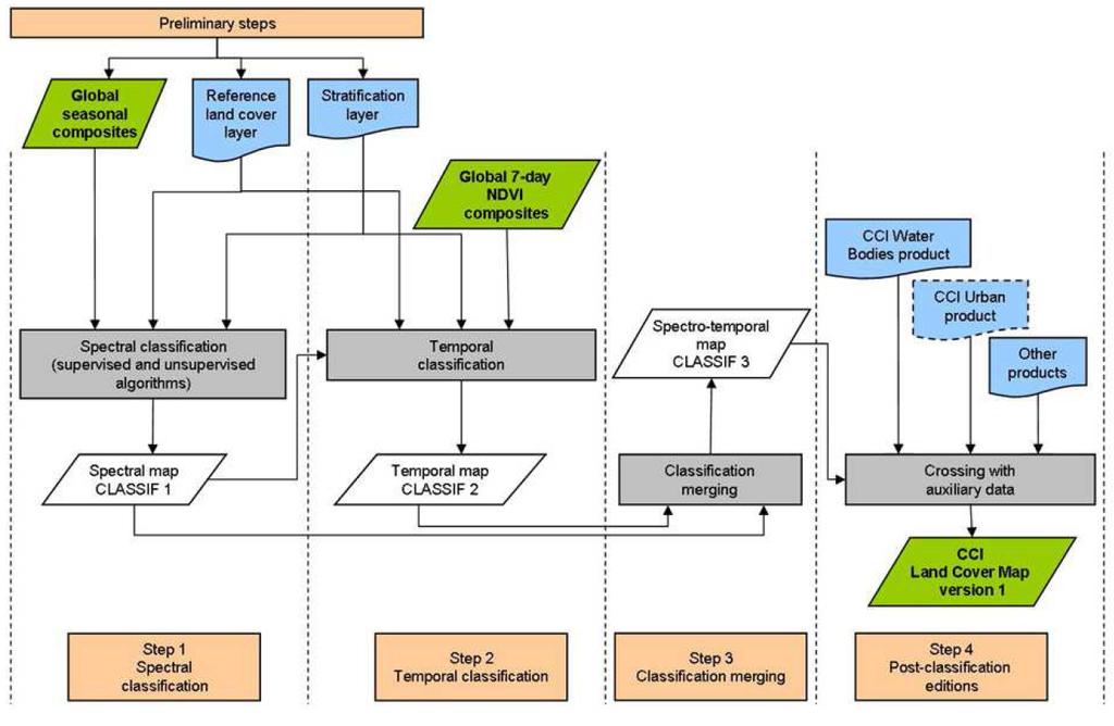
9 Classification strategy

10 Stratification layer 22 equal-reasoning regions from ecological and remote sensing point of view
 Land cover map of Canada National land cover database of United States Land cover database of Greater MesoAmerica North America Environment")
11 Reference layer Used for training dataset in the supervised classification and for labelling in the unsupervised classification algorithms Based on existing LC data: GLC2000 global and regional maps GlobCover 2005 map Corine Land Cover maps (2006 and 2000) Land cover map of Canada National land cover database of United States Land cover database of Greater MesoAmerica North America Environment Dataset GLCN Senegal land cover map Land Cover Database of Burkina Faso Africover maps Burundi Democratic Rep. Of Congo Egypt Eritrea Kenya Rwanda Somalia Sudan Tanzania Uganda Central Africa forest types map Democratic Republic of Congo map Southern Africa Development (SADC) Countries land cover map National land cover map of China Land use map of Cambodia JCR irrigated and rainfed cropmasks Global mangrove altas MODIS map of global urban extent CCI-SAR Water Body dataset


12 Compositing From 7-day composites to seasonal / annual composites

 Fusion CLASSIF 1b (unsup.")
13 Spectral classification made of supervised and unsupervised algos For each equalreasoning area Seasonal multispectral composites Reference LC layer Unsupervised classification Training dataset Machine learning classification Unlabelled spectrallyhomogeneous clusters Automated labelling Reference LC layer CLASSIF 1a (sup. spectral map) Fusion CLASSIF 1b (unsup. spectral map) CLASSIF 1 (spectral map)
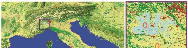
14 Supervised classification for specific patterns Unsupervised Unsupervised MERIS annual composite MERIS annual composite Supervised Supervised

15 Temporal classification CLASSIF 1 (spectral map) VI 7-day time series Mask for specific areas Unsupervised classification Unlabelled temporallyhomogeneous clusters Reference LC layer Automated labelling CLASSIF 2 (temporal map)
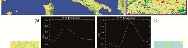
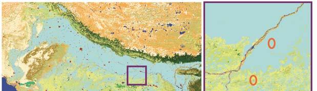
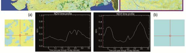
16 Temporal classification


17 Multi-year perspective for the spectral classification 2 strategies, according to the equal reasoning-area Classification chain Classification chain 10 annual global land cover products


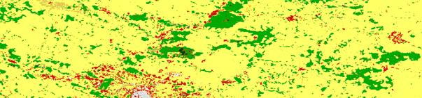
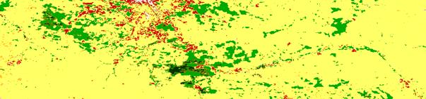
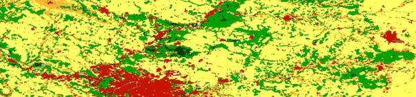
18 Multi-year perspective for the spectral classification Summary at the compositing level improves the imagery quality Annual Multi-annual

19 Multi-year perspective for the spectral classification Summary at the compositing level improves the imagery quality Annual Multi-annual
20 Multi-year perspective for the spectral classification Summary at the compositing level improves the imagery quality Annual Multi-annual

21 Multi-year perspective for the spectral classification Summary at the compositing level improves the imagery quality Annual Multi-annual When no necessary, strategy 2 with aggregation rules to interpret the multiple land cover maps
22 Multi-level classification strategy Temporal classification Multi-year approach Supervised classification Unsupervised classification

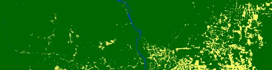
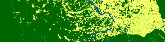
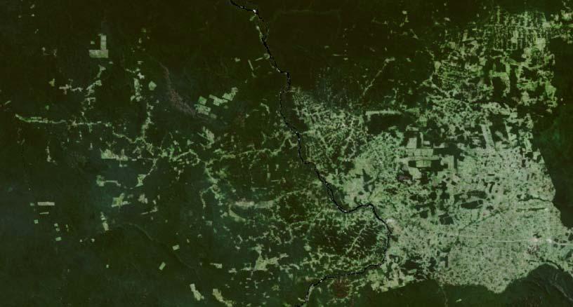
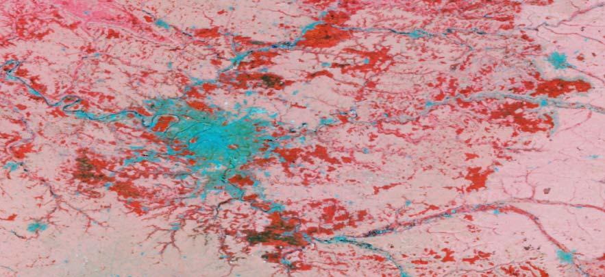
23 LC map using the composite
24 From 1 map to 3 consistent maps Fusion with LC maps from , 2009, 2010, 2011, epoch ( ) LC maps from , 2004, 2005, 2006, 2007 LC maps from , 1998, 1999, 2000, 2001, epoch ( ) INTERNAL DELIVERY END OF APRIL VALIDATED PRODUCTS PUBLICLY AVAILABLE IN AUTUMN epoch ( )


25 From 1 map to 3 consistent maps epoch

26 From 1 map to 3 consistent maps epoch 2010 epoch


27 Multi-level validation strategy Presentation of F. Achard on Tuesday

28 Thank you for your attention
ESA-GLOBCOVER - A Global Land Cover Service at 300 m from ENVISAT MERIS Time Series
 October 15, 2008 (Jena Germany) ESA-GLOBCOVER - A Global Land Cover Service at 300 m from ENVISAT MERIS Time Series Defourny P.1, Bontemps S., Vancutsem C.1, Pekel J.F.1,, Vanbogaert E.1, Bicheron P.2,
Building a validation database for land cover products from high spatial resolution images
 Building a validation database for land cover products from high spatial resolution images The Land Cover project of the ESA Climate Change Initiative Bontemps Sophie 1, Achard Frédéric 2, Lamarche Céline
Defourny P. (1), Bontemps S. (1), Brockmann C. (3), Achard F. (2), Boettcher M. (3), De Maet T. (1), Land_Cover_CCI
, Bontemps S. (1), Brockmann C. (3), Achard F. (2), Boettcher M. (3), De Maet T. (1), Land_Cover_CCI") Defourny P. (1), Bontemps S. (1), Brockmann C. (3), Achard F. (2), Boettcher M. (3), De Maet T. (1), Land_Cover_CCI Gamba P. (4), Hagemann S. (5), Hartley A. (6), Hoffman L., (11), Khlystova I.G. (5),
Defourny P. (1), Bontemps S. (1), Brockmann C. (3), Achard F. (2), Boettcher M. (3), De Maet T. (1), Land_Cover_CCI Gamba P. (4), Hagemann S. (5), Hartley A. (6), Hoffman L., (11), Khlystova I.G. (5),
CONSISTENT GLOBAL LAND COVER MAPS FOR CLIMATE MODELLING COMMUNITIES: CURRENT ACHIEVEMENTS OF THE ESA LAND COVER CCI
 CONSISTENT GLOBAL LAND COVER MAPS FOR CLIMATE MODELLING COMMUNITIES: CURRENT ACHIEVEMENTS OF THE ESA LAND COVER CCI Bontemps S. (1), Defourny P. (1), Radoux J. (1), Van Bogaert E. (1), Lamarche C. (1),
International Symposium on Land Cover Mapping for the African Continent. FAO Land Cover Mapping methodology, tools and standards & GLC SHARE database
 International Symposium on Land Cover Mapping for the African Continent June 25-27, 2013 UNEP HQ & RCMRD, Nairobi, Kenya FAO Land Cover Mapping methodology, tools and standards & GLC SHARE database R C
Mapping African buffalo distributions, in relation to livestock disease risk
 Mapping African buffalo distributions, in relation to livestock disease risk Tim Robinson and Jennifer Siembieda Buffalo Mapping Meeting 7-8 June, Rome FAO, Canada Room Overview Modelling densities of
Land Use / Land Cover Mapping in
 Land Use / Land Cover Mapping in Eastern and Southern African Regions RCMRD Experience by 6/24/2013, Nairobi Kenya Dr. Tesfaye Korme Director of RS, GIS and Mapping, RCMRD I. About RCMRD, Its Vision and
Module 2.1 Monitoring activity data for forests using remote sensing
 Module 2.1 Monitoring activity data for forests using remote sensing Module developers: Frédéric Achard, European Commission (EC) Joint Research Centre (JRC) Jukka Miettinen, EC JRC Brice Mora, Wageningen
Capabilities and Limitations of Land Cover and Satellite Data for Biomass Estimation in African Ecosystems Valerio Avitabile
 Capabilities and Limitations of Land Cover and Satellite Data for Biomass Estimation in African Ecosystems Valerio Avitabile Kaniyo Pabidi - Budongo Forest Reserve November 13th, 2008 Outline of the presentation
Access to global land cover reference datasets and their suitability for land cover mapping activities
 Access to global land cover reference datasets and their suitability for land cover mapping activities Brice Mora, N.E.Tsendbazar, M.Herold LPVE meeting, Frascati, January 29, 2014 Outlook 1. Background
Global land cover maps validation: current strategy for CCI Land Cover
 THE LAND COVER COMPONENT OF THE ESA CLIMATE CHANGE INITIATIVE Global land cover maps validation: current strategy for CCI Land Cover Defourny P. (1), Brockmann C. (3), Bontemps S. (1), Achard F. (2), Boettcher
GLOBWETLAND AFRICA TOOLBOX
 The GlobWetland Africa Toolbox is an open source and free-of-charge software toolbox for inventorying, mapping, monitoring and assessing wetlands. The toolbox comes with end-to-end processing workflows
Programme. MC : Byron Anangwe. Morning Session
 Programme MC : Byron Anangwe Morning Session DAY 2 Summary MC : Byron Anangwe The USGS global land cover mapping initiative Land use and land cover mapping at the Joint Research Centre Alan Belward FAO
Using Earth Observation Data for Monitoring River Basins
 Using Earth Observation Data for Monitoring River Basins The NBI Experience By Milly Mbuliro GIS/ Remote Sensing Specialist Nile Basin Initiative Secretariat NBDF, 23 rd -25 th October, Kigali Convention
Fire ECV Requirements NASA White paper ESA Climate Change Initiative
 Fire ECV Requirements NASA White paper ESA Climate Change Initiative Olivier Arino Frascati 26/03/2010 Two climate action paths GCOS-82 in 2003 GCOS-92 in 2004 GCOS-107 in 2006 CEOS response 2006 GEOSS
Methods review for the Global Land Cover 2000 initiative Presentation made by Frédéric Achard on November 30 th 2000
 Methods review for the Global Land Cover 2000 initiative Presentation made by Frédéric Achard on November 30 th 2000 1. Contents Objectives Specifications of the GLC-2000 exercise Strategy for the analysis
Development of a Regional Land Cover Monitoring System In the Lower Mekong Region a Joint Effort Between SERVIR-Mekong and Partners -
 Mekong Development of a Regional Land Cover Monitoring System In the Lower Mekong Region a Joint Effort Between SERVIR-Mekong and Partners - Aekkapol Aekakkararungroj SERVIR-Mekong Asian Disaster Preparedness
Sub-pixel regional land cover mapping. with MERIS imagery
 Sub-pixel regional land cover mapping with MERIS imagery R. Zurita Milla, J.G.P.W. Clevers and M. E. Schaepman Centre for Geo-information Wageningen University 29th September 2005 Overview Land Cover MERIS
Using MERIS and MODIS for Land Cover Mapping in the Netherlands
 Using MERIS and for Land Cover Mapping in the Netherlands Raul Zurita Milla, Michael Schaepman and Jan Clevers Wageningen University, Centre for Geo-Information, NL Introduction Actual and reliable information
Data Fusion and Multi-Resolution Data
 Data Fusion and Multi-Resolution Data Nature.com www.museevirtuel-virtualmuseum.ca www.srs.fs.usda.gov Meredith Gartner 3/7/14 Data fusion and multi-resolution data Dark and Bram MAUP and raster data Hilker
REMOTELY SENSED INFORMATION FOR CROP MONITORING AND FOOD SECURITY
 LEARNING OBJECTIVES Lesson 4 Methods and Analysis 2: Rainfall and NDVI Seasonal Graphs At the end of the lesson, you will be able to: understand seasonal graphs for rainfall and NDVI; describe the concept
Land Surface Processes and Land Use Change. Lex Comber
 Land Surface Processes and Land Use Change Lex Comber ajc36@le.ac.uk Land Surface Processes and Land Use Change Geographic objects in GIS databases Detecting land use change using multitemporal imaging
Predicting ectotherm disease vector spread. - Benefits from multi-disciplinary approaches and directions forward
 Predicting ectotherm disease vector spread - Benefits from multi-disciplinary approaches and directions forward Naturwissenschaften Stephanie Margarete THOMAS, Carl BEIERKUHNLEIN, Department of Biogeography,
Sentinel 2 Pre-processing Requirements for coastal and inland waters
 Sentinel 2 Pre-processing Requirements for coastal and inland waters K A I S Ø R E NSEN NIVA CARSTEN B R O CKMANN Ecological and chemical classification of water bodies in Norway Water quality - products
MANUAL ON THE BSES: LAND USE/LAND COVER
 6. Environment Protection, Management and Engagement 2. Environmental Resources and their Use 5. Human Habitat and Environmental Health 1. Environmental Conditions and Quality 4. Disasters and Extreme
LAND USE, LAND COVER AND SOIL SCIENCES Vol. I - AFRICOVER Land Cover Classification and Mapping Project - Antonio Di Gregorio, John Latham
 AFRICOVER LAND COVER CLASSIFICATION AND MAPPING PROJECT Antonio Di Gregorio Food and Agriculture Organisation of the United Nations (FAO), Africover Project, Kenya John Latham Food and Agriculture Organisation
Monitoring of Tropical Deforestation and Land Cover Changes in Protected Areas: JRC Perspective
 Monitoring of Tropical Deforestation and Land Cover Changes in Protected Areas: JRC Perspective Z. Szantoi, A. Brink, P. Mayaux, F. Achard Monitoring Of Natural resources for DEvelopment (MONDE) Joint
Land Monitoring Core Service Implementation Group (LMCS IG) - Results and Outlook
 - Results and Outlook") Land Monitoring Core Service Implementation Group (LMCS IG) - Results and Outlook Pr. Dietmar Grünreich, President of BKG, Germany Chairman of the GMES LMCS IG Outline 1 Introduction 2 Preparatory Projects
Land Monitoring Core Service Implementation Group (LMCS IG) - Results and Outlook Pr. Dietmar Grünreich, President of BKG, Germany Chairman of the GMES LMCS IG Outline 1 Introduction 2 Preparatory Projects
PRODUCT USER GUIDE VERSION 2. Land Cover CCI CCI-LC-PUG DELIVERABLE REF: DOCUMENT REF:
 Land Cover CCI PRODUCT USER GUIDE VERSION 2 DOCUMENT REF: CCI-LC-PUG DELIVERABLE REF: D3.4-PUG VERSION: 2.4 CREATION DATE: 2012-09-10 LAST MODIFIED: 2014-09-02 This page is intentionally blank. Page 3
GMFS South Sudan CFSAM Support Kit
 GMFS South Sudan CFSAM Support Kit version 1.0 October, 2011 Table of contents 1 Disclaimer... 1 2 General introduction... 1 3 South Sudan base maps and statistics... 2 3.1 Base map... 2 3.2 Agroecological
Product Specification Document
 1.rev.11 03/07/2014 1 Product Specification Document Milestone Product specification document Authors Distribution Milestone 1 Pierre Defourny (UCL), Sophie Bontemps (UCL), Céline Lamarche (UCL), Martin
LAND COVER CATEGORY DEFINITION BY IMAGE INVARIANTS FOR AUTOMATED CLASSIFICATION
 LAND COVER CATEGORY DEFINITION BY IMAGE INVARIANTS FOR AUTOMATED CLASSIFICATION Nguyen Dinh Duong Environmental Remote Sensing Laboratory Institute of Geography Hoang Quoc Viet Rd., Cau Giay, Hanoi, Vietnam
Overview on Land Cover and Land Use Monitoring in Russia
 Russian Academy of Sciences Space Research Institute Overview on Land Cover and Land Use Monitoring in Russia Sergey Bartalev Joint NASA LCLUC Science Team Meeting and GOFC-GOLD/NERIN, NEESPI Workshop
Natural Resource Management Indicators for the Least Developed Countries
 Natural Resource Management Indicators for the Least Developed Countries Alex de Sherbinin CIESIN, Columbia University 24 June 2005 Millennium Challenge Corporation workshop Brookings Institution Washington,
Leveraging Sentinel-1 time-series data for mapping agricultural land cover and land use in the tropics
 Leveraging Sentinel-1 time-series data for mapping agricultural land cover and land use in the tropics Caitlin Kontgis caitlin@descarteslabs.com @caitlinkontgis Descartes Labs Overview What is Descartes
Preparation of LULC map from GE images for GIS based Urban Hydrological Modeling
 International Conference on Modeling Tools for Sustainable Water Resources Management Department of Civil Engineering, Indian Institute of Technology Hyderabad: 28-29 December 2014 Abstract Preparation
Land Cover and Asset Mapping Operational Change Detection
 Land Cover and Asset Mapping Operational Change Detection Andreas Müller DLR DFD with the support of Charly Kaufmann, Allan Nielsen, Juliane Huth ESA Oil & Gas Workshop, 13-14 September 2010 Folie 1 TWOPAC
SATELLITE REMOTE SENSING
 SATELLITE REMOTE SENSING of NATURAL RESOURCES David L. Verbyla LEWIS PUBLISHERS Boca Raton New York London Tokyo Contents CHAPTER 1. SATELLITE IMAGES 1 Raster Image Data 2 Remote Sensing Detectors 2 Analog
AGOG 485/585 /APLN 533 Spring Lecture 5: MODIS land cover product (MCD12Q1). Additional sources of MODIS data
. Additional sources of MODIS data") AGOG 485/585 /APLN 533 Spring 2019 Lecture 5: MODIS land cover product (MCD12Q1). Additional sources of MODIS data Outline Current status of land cover products Overview of the MCD12Q1 algorithm Mapping
AGOG 485/585 /APLN 533 Spring 2019 Lecture 5: MODIS land cover product (MCD12Q1). Additional sources of MODIS data Outline Current status of land cover products Overview of the MCD12Q1 algorithm Mapping
Remote sensing monitoring of land restoration interventions in semi-arid environments
 MultiTemp 2017 Remote sensing monitoring of land restoration interventions in semi-arid environments M. Meroni 1, A. Schucknecht 1, D. Fasbender 1, F. Rembold 1, L. di Lucchio 1,5, F. Fava 2, M. Mauclaire
Mapping forests in monsoon Asia with ALOS PALSAR 50-m mosaic images and MODIS
 1 Supplementary Information 2 3 Mapping forests in monsoon Asia with ALOS PALSAR 50-m mosaic images and MODIS imagery in 2010 4 5 6 7 8 9 10 11 Yuanwei Qin, Xiangming Xiao, Jinwei Dong, Geli Zhang, Partha
GCOS High Resolution Land Cover ECV. Slide 11
 GCOS High Resolution Land Cover ECV Slide 11 Detailed Land Cover and Climate Land cover and its changes modify the goods and services provided to human society force climate by altering water and energy
Patrick Leinenkugel. German Aerospace Center (DLR) Vortrag > Autor > Dokumentname > Datum
 Vortrag > Autor > Dokumentname > Datum") Characterisation of land surface phenology and land cover for the Mekong Basin on the basis of multitemporal and multispectral satellite data from the MODIS Sensor Patrick Leinenkugel German Aerospace
Characterisation of land surface phenology and land cover for the Mekong Basin on the basis of multitemporal and multispectral satellite data from the MODIS Sensor Patrick Leinenkugel German Aerospace
Remote Sensing of Snow and Ice. Lecture 21 Nov. 9, 2005
 Remote Sensing of Snow and Ice Lecture 21 Nov. 9, 2005 Topics Remote sensing snow depth: passive microwave (covered in Lecture 14) Remote sensing sea ice and ice sheet elevation change: Lidar - ICESat
Sentinel-3: Lessons from AATSR/MERIS Synergy. Peter North Swansea University
 Sentinel-3: Lessons from AATSR/MERIS Synergy Peter North Swansea University Introduction ESA projects relevant to Sentinel-3: Aerosol CCI MERIS/AATSR Synergy GlobAlbedo SEN4LST S3 Algorithm development
PYROGEOGRAPHY OF THE IBERIAN PENINSULA
 PYROGEOGRAPHY OF THE IBERIAN PENINSULA Teresa J. Calado (1), Carlos C. DaCamara (1), Sílvia A. Nunes (1), Sofia L. Ermida (1) and Isabel F. Trigo (1,2) (1) Instituto Dom Luiz, Universidade de Lisboa, Lisboa,
An Automated Object-Oriented Satellite Image Classification Method Integrating the FAO Land Cover Classification System (LCCS).
.") An Automated Object-Oriented Satellite Image Classification Method Integrating the FAO Land Cover Classification System (LCCS). Ruvimbo Gamanya Sibanda Prof. Dr. Philippe De Maeyer Prof. Dr. Morgan De
An Automated Object-Oriented Satellite Image Classification Method Integrating the FAO Land Cover Classification System (LCCS). Ruvimbo Gamanya Sibanda Prof. Dr. Philippe De Maeyer Prof. Dr. Morgan De
Copernicus Land HRL Imperviousness: 2012 dataset, indicator Title
 Copernicus Land HRL Imperviousness: 2012 dataset, 06-09 indicator and outlook Title 2015+ Tobias LANGANKE First name SURNAME Project manager, Copernicus Position land services Name European of the Environment
Remote Sensing products and global datasets. Joint Research Centre, European Commission
 Remote Sensing products and global datasets Joint Research Centre, European Commission Setting the stage. Needs and requirements for integrated approach(es) for land degradation assessment. in Special
Urban remote sensing: from local to global and back
 Urban remote sensing: from local to global and back Paolo Gamba University of Pavia, Italy A few words about Pavia Historical University (1361) in a nice town slide 3 Geoscience and Remote Sensing Society
ESA Climate Change Initiative
 ESA Climate Change Initiative Olivier Arino Frascati, 23 June 2009 Climate Change Initiative Rationale Two climate action paths GCOS-82 in 2003 GCOS-92 in 2004 GCOS-107 in 2006 CEOS response 2006 GEOSS
Land Management and Natural Hazards Unit --- DESERT Action 1. Land Management and Natural Hazards Unit Institute for Environment and Sustainability
 Land Management and Natural Hazards Unit --- DESERT Action 1 Monitoring Drought with Meteorological and Remote Sensing Data A case study on the Horn of Africa Paulo Barbosa and Gustavo Naumann Land Management
Kyoto and Carbon Initiative - the Ramsar / Wetlands International perspective
 Kyoto and Carbon Initiative - the Ramsar / Wetlands International perspective (the thoughts of Max Finlayson, as interpreted by John Lowry) Broad Requirements Guideline(s) for delineating wetlands (specifically,
The contribution of VEGETATION
 The contribution of VEGETATION /SPOT4 products to remote sensing applications for food security, early warning and environmental monitoring in the IGAD sub region G. Pierre, C. Crépeau, P. Bicheron, T.
Permafrost: Earth Observation Applications: Introduction
 Polar Meeting 3 Permafrost: Earth Observation Applications: Introduction Mark Drinkwater CNES, Paris, 22 23 May, 2013 Remote Sensing of Permafrost which Remote Sensing products? applicability to Permafrost
Drought Bulletin for the Greater Horn of Africa: Situation in June 2011
 Drought Bulletin for the Greater Horn of Africa: Situation in June 2011 Preliminary Analysis of data from the African Drought Observatory (ADO) SUMMARY The analyses of different meteorological and remote
ESA Climate Change Initiative (CCI)
") ESA Climate Change Initiative (CCI) New ESA Programme with the aim to contribute to worldwide efforts to generate Essential Climate Variables (ECVs) C. Zehner Barcelona, 07/09/2009 Two climate action paths
ESA Climate Change Initiative (CCI) New ESA Programme with the aim to contribute to worldwide efforts to generate Essential Climate Variables (ECVs) C. Zehner Barcelona, 07/09/2009 Two climate action paths
Session 9 Spatial Decision Support Systems (SDSS)
") Session 9 Spatial Decision Support Systems (SDSS) Lead facilitator Dr. Gerard Kelly Learning Objectives The aim of this session is to review and understand the applications of a GIS-based spatial decision
Session 9 Spatial Decision Support Systems (SDSS) Lead facilitator Dr. Gerard Kelly Learning Objectives The aim of this session is to review and understand the applications of a GIS-based spatial decision
1. CLIMATIC AND ENVIRONMENTAL CONDITIONS OVER AFRICA. 1.1 Inter-Tropical Discontinuity (ITD)
") African Centre of Meteorological Application for Development Centre Africain pour les Applications de la Météorologie au Développement OCTOBER 2011 HIGHLIGHT: Cholera, Acute Water Diarrhoea, Yellow fever,
African Centre of Meteorological Application for Development Centre Africain pour les Applications de la Météorologie au Développement OCTOBER 2011 HIGHLIGHT: Cholera, Acute Water Diarrhoea, Yellow fever,
Landcover Dynamics in the Niger Inland Delta (Mali)
") Fakultät Forst-, Geo- Hydrowissenschaften Institut f. Photogrammetrie & Fernerkundung, Professur Fernerkundung Landcover Dynamics in the Niger Inland Delta (Mali) A Classification Approach for MERIS Data
Fakultät Forst-, Geo- Hydrowissenschaften Institut f. Photogrammetrie & Fernerkundung, Professur Fernerkundung Landcover Dynamics in the Niger Inland Delta (Mali) A Classification Approach for MERIS Data
System of Environmental-Economic Accounting. Advancing the SEEA Experimental Ecosystem Accounting. Extent Account (Levels 1 and 2)
") Advancing the SEEA Experimental Ecosystem Accounting Extent Account (Levels 1 and 2) Overview: The Extent Account 1. Learning objectives 2. Review of Level 0 (5m) What is it? Why do we need it? What does
Advancing the SEEA Experimental Ecosystem Accounting Extent Account (Levels 1 and 2) Overview: The Extent Account 1. Learning objectives 2. Review of Level 0 (5m) What is it? Why do we need it? What does
Mapping Priorities to Focus Cropland Mapping Activities: Fitness Assessment of Existing Global, Regional and National Cropland Maps
 Remote Sens. 2015, 7, 7959-7986; doi:10.3390/rs70607959 OPEN ACCESS remote sensing ISSN 2072-4292 www.mdpi.com/journal/remotesensing Article Mapping Priorities to Focus Cropland Mapping Activities: Fitness
ANALYSIS AND VALIDATION OF A METHODOLOGY TO EVALUATE LAND COVER CHANGE IN THE MEDITERRANEAN BASIN USING MULTITEMPORAL MODIS DATA
 PRESENT ENVIRONMENT AND SUSTAINABLE DEVELOPMENT, NR. 4, 2010 ANALYSIS AND VALIDATION OF A METHODOLOGY TO EVALUATE LAND COVER CHANGE IN THE MEDITERRANEAN BASIN USING MULTITEMPORAL MODIS DATA Mara Pilloni
Projecting Urban Land Cover on the basis of Population
 Projecting Urban Land Cover on the basis of Population Dan Miller Runfola Postdoctoral Researcher National Center for Atmospheric Research CGD & RAL CU:Boulder Institute of Behavioral Science 1 The Challenge
REMOTELY SENSED INFORMATION FOR CROP MONITORING AND FOOD SECURITY
 LEARNING OBJECTIVES Lesson 4 Methods and Analysis 2: Rainfall and NDVI Seasonal Graphs At the end of the lesson, you will be able to: understand seasonal graphs for rainfall and NDVI; describe the concept
Land Cover Classification Over Penang Island, Malaysia Using SPOT Data
 Land Cover Classification Over Penang Island, Malaysia Using SPOT Data School of Physics, Universiti Sains Malaysia, 11800 Penang, Malaysia. Tel: +604-6533663, Fax: +604-6579150 E-mail: hslim@usm.my, mjafri@usm.my,
Training on national land cover classification systems. Toward the integration of forest and other land use mapping activities.
 Training on national land cover classification systems Toward the integration of forest and other land use mapping activities. Guiana Shield 9 to 13 March 2015, Paramaribo, Suriname Background Sustainable
Land cover/land use mapping and cha Mongolian plateau using remote sens. Title. Author(s) Bagan, Hasi; Yamagata, Yoshiki. Citation Japan.
 Bagan, Hasi; Yamagata, Yoshiki. Citation Japan.") Title Land cover/land use mapping and cha Mongolian plateau using remote sens Author(s) Bagan, Hasi; Yamagata, Yoshiki International Symposium on "The Imp Citation Region Specific Systems". 6 Nove Japan.
Title Land cover/land use mapping and cha Mongolian plateau using remote sens Author(s) Bagan, Hasi; Yamagata, Yoshiki International Symposium on "The Imp Citation Region Specific Systems". 6 Nove Japan.
Science Leaders Discussion
 Science Leaders Discussion Introductions, agenda and expectations Broad thinking Science opportunities Aspirations and plans for Phase 2 FP7 / GMES and long term positioning Specific thinking Co-ordination
Monitoring daily evapotranspiration in the Alps exploiting Sentinel-2 and meteorological data
 Monitoring daily evapotranspiration in the Alps exploiting Sentinel-2 and meteorological data M. Castelli, S. Asam, A. Jacob, M. Zebisch, and C. Notarnicola Institute for Earth Observation, Eurac Research,
Jordan Land Cover Mapping Data Preparation. Emanuela De Leo, John Latham, Lorenzo De Simone (DDNS)
") Jordan Land Cover Mapping Data Preparation Emanuela De Leo, John Latham, Lorenzo De Simone (DDNS) FOOD AND AGRICULTURE ORGANIZATION OF THE UNITED NATIONS Rome 2016 2 FAO/Jordan Land Cover and Land Cover
Jordan Land Cover Mapping Data Preparation Emanuela De Leo, John Latham, Lorenzo De Simone (DDNS) FOOD AND AGRICULTURE ORGANIZATION OF THE UNITED NATIONS Rome 2016 2 FAO/Jordan Land Cover and Land Cover
Spanish national plan for land observation: new collaborative production system in Europe
 ADVANCE UNEDITED VERSION UNITED NATIONS E/CONF.103/5/Add.1 Economic and Social Affairs 9 July 2013 Tenth United Nations Regional Cartographic Conference for the Americas New York, 19-23, August 2013 Item
Sandra Lohberger, Werner Wiedemann, Florian Siegert
 FIRE_CCI Special Case Study on Fires in Indonesia and El Niño: Object-based burned area detection and related fire emission estimations based on Sentinel-1 data D4 Burned area 216 Prepared for European
Evaluation of ESA CCI prototype land cover map at 20m
 Evaluation of ESA CCI prototype land cover map at 20m Lesiv, M., Fritz, S., McCallum, I., Tsendbazar, N., Herold, M., Pekel, J.-F., Buchhorn, M., Smets, B. & Van De Kerchove, R. IIASA Working Paper WP-17-021
MODIS Snow Cover Mapping Decision Tree Technique: Snow and Cloud Discrimination
 67 th EASTERN SNOW CONFERENCE Jiminy Peak Mountain Resort, Hancock, MA, USA 2010 MODIS Snow Cover Mapping Decision Tree Technique: Snow and Cloud Discrimination GEORGE RIGGS 1, AND DOROTHY K. HALL 2 ABSTRACT
Cost-Effective Estimation of Vegetation Regrowth on Anthropogenic Features in NE BC (REMB )
") Cost-Effective Estimation of Vegetation Regrowth on Anthropogenic Features in NE BC (REMB-2017-02) FINAL PROJECT REPORT October 31, 2018 Project [1475-1] Prepared by: Prepared for: Jacqueline Howard Resource
Cost-Effective Estimation of Vegetation Regrowth on Anthropogenic Features in NE BC (REMB-2017-02) FINAL PROJECT REPORT October 31, 2018 Project [1475-1] Prepared by: Prepared for: Jacqueline Howard Resource
In-flight Calibration Techniques Using Natural Targets. CNES Activities on Calibration of Space Sensors
 In-flight Calibration Techniques Using Natural Targets CNES Activities on Calibration of Space Sensors Bertrand Fougnie, Patrice Henry (DCT/SI, CNES, Toulouse, France) In-flight Calibration using Natural
Pan-Arctic, Regional and Local Land Cover Products
 Pan-Arctic, Regional and Local Land Cover Products Marcel Urban (1), Stefan Pöcking (1), Sören Hese (1) & Christiane Schmullius (1) (1) Friedrich-Schiller University Jena, Department of Earth Observation,
LAND COVER / LAND USE MAP OF GERMANY BASED ON MERIS FULL RESOLUTION DATA
 LAND COVER / LAND USE MAP OF GERMANY BASED ON MERIS FULL RESOLUTION DATA U. Geßner (1), K. P. Günther (2), S. W. Maier (3) (1) German Aerospace Center (DLR) German Remote Sensing Data Center (DFD) Münchnerstraße
Temporal and spatial approaches for land cover classification.
 Temporal and spatial approaches for land cover classification. Ryabukhin Sergey sergeyryabukhin@gmail.com Abstract. This paper describes solution for Time Series Land Cover Classification Challenge (TiSeLaC).
North-South Gap Mapping Assignment Country Classification / Statistical Analysis
 North-South Gap Mapping Assignment Country Classification / Statistical Analysis Due Date: (Total Value: 55 points) Name: Date: Learning Outcomes: By successfully completing this assignment, you will be
African requirements for SDI standardization Antony Cooper Operating Unit Fellow Built Environment CSIR PO Box 395, Pretoria, 0001, South Africa
 ISO/TC 211 workshop on spatial data infrastructures (SDIs) African requirements for SDI standardization Antony Cooper Operating Unit Fellow Built Environment CSIR PO Box 395, Pretoria, 0001, South Africa
UK Contribution to the European CORINE Land Cover
 Centre for Landscape andwww.le.ac.uk/clcr Climate Research CENTRE FOR Landscape and Climate Research UK Contribution to the European CORINE Land Cover Dr Beth Cole Corine Coordination of Information on
C N E S, U M R I R I S A
 M O N I T O R I N G U R B A N A R E A S W I T H S E N T I N E L - 2. APPLICATION TO THE UPDATE OF THE COPERNICUS HIGH RESOLUTION LAYER IMPERVIOUSNESS DEGREE O c t o b e r 2 5 th 2016, Brussels A n t o
Greening of Arctic: Knowledge and Uncertainties
 Greening of Arctic: Knowledge and Uncertainties Jiong Jia, Hesong Wang Chinese Academy of Science jiong@tea.ac.cn Howie Epstein Skip Walker Moscow, January 28, 2008 Global Warming and Its Impact IMPACTS
Sedimentation in the Nile River
 Advanced Training Workshop on Reservoir Sedimentation Sedimentation in the Nile River Prof. Dr. Abdalla Abdelsalam Ahmed 10-16 Oct. 2007, IRTCES, Beijing, China CWR,Sudan 1 Water is essential for mankind
Cloud masking as cross-cutting issue
 Cloud masking as cross-cutting issue Presentation to CEOS/WGCV activity project planning meeting Rainer Hollmann, Cornelia Schlundt, Satellite based Climate Monitoring Deutscher Wetterdienst Outline Need
The LISA extension to INSPIRE LC/LU data model: The Austrian experience
 The LISA extension to INSPIRE LC/LU data model: The Austrian experience Gebhard Banko, Environment Agency Austria Roland Grillmayer, Environment Agency Austria Wolfgang Stemberger, GeoVille INSPIRE KEN
Data sources and classification for ecosystem accounting g
 Data sources and classification for ecosystem accounting Ken Bagstad 23 February 2015 Wealth Accounting and the Valuation of Ecosystem Services www.wavespartnership.org Data sources and classification
Mapping Global Urban Area from DMSP/OLS Nightlights using a Cluster-based Method
 Mapping Global Urban Area from DMSP/OLS Nightlights using a Cluster-based Method Y. ZHOU, S. SMITH, A. THOMSON, B. BOND-LAMBERTY, M. IMHOFF K. ZHAO, C. ELVIDGE, J. EOM, K. CLARKE Joint Global Change Research
choice have on a particular application? For example, Fritz et al. (2010a) have shown that comparing global land cover (GLC-2000) with the equivalent
 have shown that comparing global land cover (GLC-2000) with the equivalent") Improving Global Land Cover through Crowd-sourcing and Map Integration L. See 1, S. Fritz 1, I. McCallum 1, C. Schill 2, C. Perger 3 and M. Obersteiner 1 1 International Institute for Applied Systems Analysis
Improving Global Land Cover through Crowd-sourcing and Map Integration L. See 1, S. Fritz 1, I. McCallum 1, C. Schill 2, C. Perger 3 and M. Obersteiner 1 1 International Institute for Applied Systems Analysis
Deriving Landcover Information over Siberia using MERIS and MODIS data
 Deriving Landcover Information over Siberia using MERIS and data Dr Laine Skinner (1) and Dr Adrian Luckman (1) (1) University of Wales Swansea, Singleton Park, SA2 8PP Swansea, UK. gglskinn@swan.ac.uk
APPENDIX. Normalized Difference Vegetation Index (NDVI) from MODIS data
 from MODIS data") APPENDIX Land-use/land-cover composition of Apulia region Overall, more than 82% of Apulia contains agro-ecosystems (Figure ). The northern and somewhat the central part of the region include arable lands
APPENDIX Land-use/land-cover composition of Apulia region Overall, more than 82% of Apulia contains agro-ecosystems (Figure ). The northern and somewhat the central part of the region include arable lands
Product Notice ID. OL_2_LFR in NRT and NTC OL_2_LRR in NRT and NTC. Product. Issue/Rev Date 25/01/2019 Version 1.0
 S3 Product Notice OLCI Mission Sensor Product & OLCI OL_2_LFR in NRT and NTC OL_2_LRR in NRT and NTC Product Notice ID S3.PN-OLCI-L2L.02 Issue/Rev Date 25/01/2019 Version 1.0 Preparation This Product Notice
Paper presented at the 9th AGILE Conference on Geographic Information Science, Visegrád, Hungary,
 Paper presented at the 9th AGILE Conference on Geographic Information Science, Visegrád, Hungary, 2006 21 Validation of MODIS Snowcover Products in Romania. Methodology and conclusions C. Flueraru, G.
Characterizing Urbanization Processes in West Africa using Multi-temporal Earth Observation Data
 Characterizing Urbanization Processes in West Africa using Multi-temporal Earth Observation Data Sebastian van der Linden 1,2 Franz Schug 2 Akpona Okujen 2 Patrick Hostert 1,2 Jonas Ø. Nielsen 1,2 Janine
Making a Mental Map of the Region
 Africa Preview Making a Mental Map of the Region Draw an outline map of Africa on the next page or on a separate sheet of paper. Add a compass rose to your map, showing where north, south, east, and west
Cross-Sensor Continuity Science Algorithm
 Cross-Sensor Continuity Science Algorithm - Long Term Vegetation Index and Phenology Workshop - Javzan Tsend-Ayush and Tomoaki Miura Department of Natural Resources and Environmental Management University
Landuse and Landcover change analysis in Selaiyur village, Tambaram taluk, Chennai
 Landuse and Landcover change analysis in Selaiyur village, Tambaram taluk, Chennai K. Ilayaraja Department of Civil Engineering BIST, Bharath University Selaiyur, Chennai 73 ABSTRACT The synoptic picture