Building a validation database for land cover products from high spatial resolution images
|
|
|
- Antony Blake Wright
- 5 years ago
- Views:
Transcription


1 Building a validation database for land cover products from high spatial resolution images The Land Cover project of the ESA Climate Change Initiative Bontemps Sophie 1, Achard Frédéric 2, Lamarche Céline 1, Mayaux Philippe 2, Seifert Frank-Martin 3, Arino Olivier 3, Defourny Pierre 1 1: UCLouvain, Belgium; 2: Joint Research Center, Italy; 3: ESA, ESRIN, Italy


2 Land cover as an operational product What about products quality?
3 Validation The process of assessing, by independent means, the quality of the data products derived from the system outputs (CEOS-WGCV definition) CEOS 4-level validation approach according to the temporal and spatial coverage of available reference data CEOS validation stage Stage 1 Stage 2 Stage 3 Stage 4 Characteristics Product accuracy is assessed from a small (typically < 30) set of locations and time periods by comparison with in-situ or other suitable reference data. Product accuracy is estimated over a significant set of locations and time periods by comparison with reference in situ or other suitable reference data. Spatial and temporal consistency of the product and with similar products has been evaluated over globally representative locations and time periods. Results are published in the peer-reviewed literature. Uncertainties in the product and its associated structure are well quantified from comparison with reference in situ or other suitable reference data. Uncertainties are characterized in a statistically robust way over multiple locations and time periods representing global conditions. Spatial and temporal consistency of the product and with similar products has been evaluated over globally representative locations and periods. Results are published in the peer-reviewed literature. Validation results for stage 3 are systematically updated when new product versions are released and as the time-series expands.
 Phase 2 (2014-2016) http://www.")
4 The CCI Land Cover project ESA Climate Change Initiative to provide a comprehensive and timely response to the need for long-term satellite-based products in the climate domain Land Cover project to generate global LC maps consistent over time, to match the needs of key users of the climate modelling community. Phase 1 ( ) Phase 2 ( )


5 The CCI Land Cover project 3 consistent global LC maps Envisat MERIS Full & Reduced Resolution m SPOT-Vegetation 1 & m Envisat ASAR Mainly Wide Swath Mode (150m)


6 CCI-LC validation strategy
7 CCI-LC quantitative accuracy assessment 1. Stratified random sampling of sites 2. Collection of high resolution imagery 3. Pre-processing of high resolution imagery 4. Development of a validation dedicated tool 5. Generation of the reference dataset (image interpretation) 6. Comparison between reference dataset and CCI land cover products

8 Stratified random sampling 1. Stratified random sampling of sites Sampling design : systematic + 2-stage stratification + random Systematic sampling of the FAO FRA RSS / JRC TREES + diminution of sample intensity with higher latitudes (for equal-probability of samples selection) + stratification for lower intensity in very homogenous desert areas
9 20 km 8 km Stratified random sampling 1. Stratified random sampling of high-resolution sites Sampling design : systematic + 2-stage stratification + random 8 km Final random selection => 2600 sampling units distributed globally in a systematic stratified random manner

 2010 2005 2000 Relying on Google Earth")
10 Collection of high resolution imagery 1. Stratified random sampling of sites 2. Collection of high resolution imagery To allow the validation of the 3 epochs (2010, 2005, 2000) Relying on Google Earth facilities Collecting Landsat imagery for years 2000, 2005 and 2010 (GLS)
11 Imagery pre-processing 1. Stratified random sampling of sites 2. Collection of high resolution imagery 3. Pre-processing of high resolution imagery Per-object approach: selection of segmentation parameters (object size, compactness, etc.) suitable for a wide variety of landscapes to avoid under-and over-segmentation
12 Imagery segmentation Under segmentation
13 Imagery segmentation Over segmentation

14 Imagery segmentation Correct segmentation

15 Validation interface 1. Stratified random sampling of sites 2. Collection of high resolution imagery 3. Pre-processing of high resolution imagery 4. Development of a validation dedicated tool On-line interpretation interface derived from the GlobCover tool
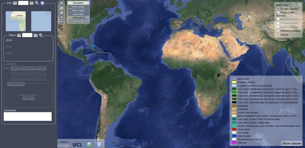
16 Validation interface
 4.")
17 Validation interface 1. Layer box 2. Zooms 3. Tools (navigation, NDVI, select object, paint class) 4. Legend 5. Comment

18 Validation interface Step 1: use all information for assign class in the 2010 period Step 2: indicate the level of certainty for the entire interpretation

19 Validation interface Step 3: evaluate the change between the 3 epochs, by «back-dating» the 2010 interpretation Step 4: indicate the level of certainty for the entire interpretation


20 Insular SE Asia: Forest Class


21 Thailand: mixed land use

22 Image interpretation 1. Stratified random sampling of sites 2. Collection of high resolution imagery 3. Pre-processing of high resolution imagery 4. Development of a validation dedicated tool 5. Generation of the reference dataset High-resolution image interpretation by experts in a standardized manner on the developed tool
23 Already a great success with great possibilities for future All experts involved in validation quite happy with the tool: friendly and easy to use, clear interpretation framework, on-line Resulting database: Plenty information that need to be fully exploited 2010 interpretation + level of certainty change information + level of certainty Each sample as a set of objects Homogenity of the sample Interpretation of all LC classes in the unit in a single LC class, in a mosaic, in LC fractions, etc. Used in the CCI-LC project but the use of VHR images coupled with a perobject should allow using it for other maps with lower-higher spatial resolution


, to use temporal information inside the sample")
24 Sentinel-2 opportunities Use of S2 imagery instead of Google Earth Less variability in the images to segment (sensor, dates, pre-processing performance, etc.) => better segments delineation Deriving NDVI time profiles from high resolution dataset (S2 being compatible with other HR missions Landsat 8), to use temporal information inside the sample unit Broadleaf or needleleaf? Rainfed or irrigated?
25 Perspectives Validation tool based on GLC2000, GlobCover, FAO-FRA RSS / JRC-TREES previous projects lessons learned Precursor for operational LC validation activities in collaboration with international scientific community As a concept: Per-object approach inside a given area ensure the scalability of the resulting database => could be used to validate Sentinel-2 LC maps Relies on the availability of a large amount of good quality reference imagery at high spatial resolution => boosted by the unique amount of Sentinel-2 data. As a tool: could be of use in many other types of activities (validation, insitu data collection, crowd-sourcing, etc.), all of them being in link with high spatial resolution imagery Sentinel-2 to make a significant difference as data source and as application

26 Thank you for your attention
Defourny P. (1), Bontemps S. (1), Brockmann C. (3), Achard F. (2), Boettcher M. (3), De Maet T. (1), Land_Cover_CCI
, Bontemps S. (1), Brockmann C. (3), Achard F. (2), Boettcher M. (3), De Maet T. (1), Land_Cover_CCI") Defourny P. (1), Bontemps S. (1), Brockmann C. (3), Achard F. (2), Boettcher M. (3), De Maet T. (1), Land_Cover_CCI Gamba P. (4), Hagemann S. (5), Hartley A. (6), Hoffman L., (11), Khlystova I.G. (5),
Defourny P. (1), Bontemps S. (1), Brockmann C. (3), Achard F. (2), Boettcher M. (3), De Maet T. (1), Land_Cover_CCI Gamba P. (4), Hagemann S. (5), Hartley A. (6), Hoffman L., (11), Khlystova I.G. (5),
Land Cover Project ESA Climate Change Initiative. Processing chain for land cover maps dedicated to climate modellers.
 Land Cover Project ESA Climate Change Initiative Processing chain for land cover maps dedicated to climate modellers land_cover_cci S. Bontemps 1, P. Defourny 1, V. Kalogirou 2, F.M. Seifert 2 and O. Arino
Defourny P. (1), Bontemps S. (1), Brockmann C. (3), Achard F. (2), Boettcher M. (3), De Maet T. (1), Land_Cover_CCI
, Bontemps S. (1), Brockmann C. (3), Achard F. (2), Boettcher M. (3), De Maet T. (1), Land_Cover_CCI") Defourny P. (1), Bontemps S. (1), Brockmann C. (3), Achard F. (2), Boettcher M. (3), De Maet T. (1), Land_Cover_CCI Gamba P. (4), Hagemann S. (5), Hartley A. (6), Hoffman L., (11), Khlystova I.G. (5),
Defourny P. (1), Bontemps S. (1), Brockmann C. (3), Achard F. (2), Boettcher M. (3), De Maet T. (1), Land_Cover_CCI Gamba P. (4), Hagemann S. (5), Hartley A. (6), Hoffman L., (11), Khlystova I.G. (5),
Global land cover maps validation: current strategy for CCI Land Cover
 THE LAND COVER COMPONENT OF THE ESA CLIMATE CHANGE INITIATIVE Global land cover maps validation: current strategy for CCI Land Cover Defourny P. (1), Brockmann C. (3), Bontemps S. (1), Achard F. (2), Boettcher
CONSISTENT GLOBAL LAND COVER MAPS FOR CLIMATE MODELLING COMMUNITIES: CURRENT ACHIEVEMENTS OF THE ESA LAND COVER CCI
 CONSISTENT GLOBAL LAND COVER MAPS FOR CLIMATE MODELLING COMMUNITIES: CURRENT ACHIEVEMENTS OF THE ESA LAND COVER CCI Bontemps S. (1), Defourny P. (1), Radoux J. (1), Van Bogaert E. (1), Lamarche C. (1),
Access to global land cover reference datasets and their suitability for land cover mapping activities
 Access to global land cover reference datasets and their suitability for land cover mapping activities Brice Mora, N.E.Tsendbazar, M.Herold LPVE meeting, Frascati, January 29, 2014 Outlook 1. Background
ESA-GLOBCOVER - A Global Land Cover Service at 300 m from ENVISAT MERIS Time Series
 October 15, 2008 (Jena Germany) ESA-GLOBCOVER - A Global Land Cover Service at 300 m from ENVISAT MERIS Time Series Defourny P.1, Bontemps S., Vancutsem C.1, Pekel J.F.1,, Vanbogaert E.1, Bicheron P.2,
Module 2.1 Monitoring activity data for forests using remote sensing
 Module 2.1 Monitoring activity data for forests using remote sensing Module developers: Frédéric Achard, European Commission (EC) Joint Research Centre (JRC) Jukka Miettinen, EC JRC Brice Mora, Wageningen
Mapping forests in monsoon Asia with ALOS PALSAR 50-m mosaic images and MODIS
 1 Supplementary Information 2 3 Mapping forests in monsoon Asia with ALOS PALSAR 50-m mosaic images and MODIS imagery in 2010 4 5 6 7 8 9 10 11 Yuanwei Qin, Xiangming Xiao, Jinwei Dong, Geli Zhang, Partha
PRODUCT USER GUIDE VERSION 2. Land Cover CCI CCI-LC-PUG DELIVERABLE REF: DOCUMENT REF:
 Land Cover CCI PRODUCT USER GUIDE VERSION 2 DOCUMENT REF: CCI-LC-PUG DELIVERABLE REF: D3.4-PUG VERSION: 2.4 CREATION DATE: 2012-09-10 LAST MODIFIED: 2014-09-02 This page is intentionally blank. Page 3
choice have on a particular application? For example, Fritz et al. (2010a) have shown that comparing global land cover (GLC-2000) with the equivalent
 have shown that comparing global land cover (GLC-2000) with the equivalent") Improving Global Land Cover through Crowd-sourcing and Map Integration L. See 1, S. Fritz 1, I. McCallum 1, C. Schill 2, C. Perger 3 and M. Obersteiner 1 1 International Institute for Applied Systems Analysis
Improving Global Land Cover through Crowd-sourcing and Map Integration L. See 1, S. Fritz 1, I. McCallum 1, C. Schill 2, C. Perger 3 and M. Obersteiner 1 1 International Institute for Applied Systems Analysis
International Symposium on Land Cover Mapping for the African Continent. FAO Land Cover Mapping methodology, tools and standards & GLC SHARE database
 International Symposium on Land Cover Mapping for the African Continent June 25-27, 2013 UNEP HQ & RCMRD, Nairobi, Kenya FAO Land Cover Mapping methodology, tools and standards & GLC SHARE database R C
ESA Climate Change Initiative (CCI)
") ESA Climate Change Initiative (CCI) New ESA Programme with the aim to contribute to worldwide efforts to generate Essential Climate Variables (ECVs) C. Zehner Barcelona, 07/09/2009 Two climate action paths
ESA Climate Change Initiative (CCI) New ESA Programme with the aim to contribute to worldwide efforts to generate Essential Climate Variables (ECVs) C. Zehner Barcelona, 07/09/2009 Two climate action paths
An Automated Object-Oriented Satellite Image Classification Method Integrating the FAO Land Cover Classification System (LCCS).
.") An Automated Object-Oriented Satellite Image Classification Method Integrating the FAO Land Cover Classification System (LCCS). Ruvimbo Gamanya Sibanda Prof. Dr. Philippe De Maeyer Prof. Dr. Morgan De
An Automated Object-Oriented Satellite Image Classification Method Integrating the FAO Land Cover Classification System (LCCS). Ruvimbo Gamanya Sibanda Prof. Dr. Philippe De Maeyer Prof. Dr. Morgan De
GCOS High Resolution Land Cover ECV. Slide 11
 GCOS High Resolution Land Cover ECV Slide 11 Detailed Land Cover and Climate Land cover and its changes modify the goods and services provided to human society force climate by altering water and energy
CadasterENV Sweden Time series in support of a multi-purpose land cover mapping system at national scale
 CadasterENV Sweden Time series in support of a multi-purpose land cover mapping system at national scale Mats Rosengren, Camilla Jönsson ; Metria AB Marc Paganini ; ESA ESRIN Background CadasterENV Sweden
C o p e r n i c u s L a n d M o n i t o r i n g S e r v i c e
 C o p e r n i c u s L a n d M o n i t o r i n g S e r v i c e Integration into existing Snow and Ice Services and draft product specifications Annett BARTSCH b.geos Copernicus High Resolution Snow and
Methods review for the Global Land Cover 2000 initiative Presentation made by Frédéric Achard on November 30 th 2000
 Methods review for the Global Land Cover 2000 initiative Presentation made by Frédéric Achard on November 30 th 2000 1. Contents Objectives Specifications of the GLC-2000 exercise Strategy for the analysis
SIGMA thematic map validation
 LPVE 2018 1 LPVE 2018 2 SIGMA GIS validation tools Thematic map validation plugin with 3 tools: Estimate sample size tool Estimate sample size using map class accuracies tool Build confusion matrix - tool
Urban areas & climate change
 Urban areas & climate change Paolo Gamba University of Pavia University of Pavia The UNIPV TLC & RS Lab is a dynamic research group developing in the past years many techniques devoted to the analysis
Capabilities and Limitations of Land Cover and Satellite Data for Biomass Estimation in African Ecosystems Valerio Avitabile
 Capabilities and Limitations of Land Cover and Satellite Data for Biomass Estimation in African Ecosystems Valerio Avitabile Kaniyo Pabidi - Budongo Forest Reserve November 13th, 2008 Outline of the presentation
Remote Sensing products and global datasets. Joint Research Centre, European Commission
 Remote Sensing products and global datasets Joint Research Centre, European Commission Setting the stage. Needs and requirements for integrated approach(es) for land degradation assessment. in Special
Programme. MC : Byron Anangwe. Morning Session
 Programme MC : Byron Anangwe Morning Session DAY 2 Summary MC : Byron Anangwe The USGS global land cover mapping initiative Land use and land cover mapping at the Joint Research Centre Alan Belward FAO
ESA Climate Change Initiative
 ESA Climate Change Initiative Olivier Arino Frascati, 23 June 2009 Climate Change Initiative Rationale Two climate action paths GCOS-82 in 2003 GCOS-92 in 2004 GCOS-107 in 2006 CEOS response 2006 GEOSS
Tropics & Sub-Tropics. How can predictive approaches be improved: Data Sparse Situations
 Tropics & Sub-Tropics How can predictive approaches be improved: Data Sparse Situations 1. Protocol for catchment function diagnostics and model setup. Use of a decision tree as a preliminary stage to
Product Specification Document
 1.rev.11 03/07/2014 1 Product Specification Document Milestone Product specification document Authors Distribution Milestone 1 Pierre Defourny (UCL), Sophie Bontemps (UCL), Céline Lamarche (UCL), Martin
Patrick Leinenkugel. German Aerospace Center (DLR) Vortrag > Autor > Dokumentname > Datum
 Vortrag > Autor > Dokumentname > Datum") Characterisation of land surface phenology and land cover for the Mekong Basin on the basis of multitemporal and multispectral satellite data from the MODIS Sensor Patrick Leinenkugel German Aerospace
Characterisation of land surface phenology and land cover for the Mekong Basin on the basis of multitemporal and multispectral satellite data from the MODIS Sensor Patrick Leinenkugel German Aerospace
CNES WGCV-36 Report Cal/Val Activities
 CEOS WGCV Meeting 13-17th May 2013, Shangai, China CNES WGCV-36 Report Cal/Val Activities Bertrand Fougnie, Sophie Lachérade, Denis Jouglet, Eric Péquignot, Aimé Meygret, Patrice Henry CNES 1 Summary Pleiades
User Manual for the JRC Land Cover/Use Change Validation Tool
 User Manual for the JRC Land Cover/Use Change Validation Tool Tool developed in the framework to the JRC TREES-3 project, in support to the Remote Sensing Survey of the Global Forest Resources Assessment
Deriving Landcover Information over Siberia using MERIS and MODIS data
 Deriving Landcover Information over Siberia using MERIS and data Dr Laine Skinner (1) and Dr Adrian Luckman (1) (1) University of Wales Swansea, Singleton Park, SA2 8PP Swansea, UK. gglskinn@swan.ac.uk
Monitoring of Tropical Deforestation and Land Cover Changes in Protected Areas: JRC Perspective
 Monitoring of Tropical Deforestation and Land Cover Changes in Protected Areas: JRC Perspective Z. Szantoi, A. Brink, P. Mayaux, F. Achard Monitoring Of Natural resources for DEvelopment (MONDE) Joint
Permafrost: Earth Observation Applications: Introduction
 Polar Meeting 3 Permafrost: Earth Observation Applications: Introduction Mark Drinkwater CNES, Paris, 22 23 May, 2013 Remote Sensing of Permafrost which Remote Sensing products? applicability to Permafrost
Cross-Sensor Continuity Science Algorithm
 Cross-Sensor Continuity Science Algorithm - Long Term Vegetation Index and Phenology Workshop - Javzan Tsend-Ayush and Tomoaki Miura Department of Natural Resources and Environmental Management University
Experience learned and recommendations from AATSR Land Surface Temperature (and Emissivity)
") Experience learned and recommendations from AATSR Land Surface Temperature (and Emissivity) Gary Corlett 1, Darren Ghent 1, John Remedios 1, Philipp Schneider 2, Simon Hook 3 1 University of Leicester,
Experience learned and recommendations from AATSR Land Surface Temperature (and Emissivity) Gary Corlett 1, Darren Ghent 1, John Remedios 1, Philipp Schneider 2, Simon Hook 3 1 University of Leicester,
Sentinel-3: Lessons from AATSR/MERIS Synergy. Peter North Swansea University
 Sentinel-3: Lessons from AATSR/MERIS Synergy Peter North Swansea University Introduction ESA projects relevant to Sentinel-3: Aerosol CCI MERIS/AATSR Synergy GlobAlbedo SEN4LST S3 Algorithm development
Land Management and Natural Hazards Unit --- DESERT Action 1. Land Management and Natural Hazards Unit Institute for Environment and Sustainability
 Land Management and Natural Hazards Unit --- DESERT Action 1 Monitoring Drought with Meteorological and Remote Sensing Data A case study on the Horn of Africa Paulo Barbosa and Gustavo Naumann Land Management
Evaluation of ESA CCI prototype land cover map at 20m
 Evaluation of ESA CCI prototype land cover map at 20m Lesiv, M., Fritz, S., McCallum, I., Tsendbazar, N., Herold, M., Pekel, J.-F., Buchhorn, M., Smets, B. & Van De Kerchove, R. IIASA Working Paper WP-17-021
Remote sensing monitoring of land restoration interventions in semi-arid environments
 MultiTemp 2017 Remote sensing monitoring of land restoration interventions in semi-arid environments M. Meroni 1, A. Schucknecht 1, D. Fasbender 1, F. Rembold 1, L. di Lucchio 1,5, F. Fava 2, M. Mauclaire
Ocean Colour: Calibration Approach. CEOS WGCV-39, May The International Ocean Colour Coordinating Group
 Ocean Colour: Calibration Approach CEOS WGCV-39, May 2015 The International Ocean Colour Coordinating Group Ocean Colour requires special calibration considerations Percentage of ocean signal in the total
Green areas: numerous positive effects for sustainable metropolis Satellite images : an easy way to map vegetation
 Green areas: numerous positive effects for sustainable metropolis Satellite images : an easy way to map vegetation Copernicus Training and Information Session 10 and 11 may 2017 in Lund, Sweden Dominique
Urban land cover and land use extraction from Very High Resolution remote sensing imagery
 Urban land cover and land use extraction from Very High Resolution remote sensing imagery Mengmeng Li* 1, Alfred Stein 1, Wietske Bijker 1, Kirsten M.de Beurs 2 1 Faculty of Geo-Information Science and
Development of a Regional Land Cover Monitoring System In the Lower Mekong Region a Joint Effort Between SERVIR-Mekong and Partners -
 Mekong Development of a Regional Land Cover Monitoring System In the Lower Mekong Region a Joint Effort Between SERVIR-Mekong and Partners - Aekkapol Aekakkararungroj SERVIR-Mekong Asian Disaster Preparedness
AGOG 485/585 /APLN 533 Spring Lecture 5: MODIS land cover product (MCD12Q1). Additional sources of MODIS data
. Additional sources of MODIS data") AGOG 485/585 /APLN 533 Spring 2019 Lecture 5: MODIS land cover product (MCD12Q1). Additional sources of MODIS data Outline Current status of land cover products Overview of the MCD12Q1 algorithm Mapping
AGOG 485/585 /APLN 533 Spring 2019 Lecture 5: MODIS land cover product (MCD12Q1). Additional sources of MODIS data Outline Current status of land cover products Overview of the MCD12Q1 algorithm Mapping
Ice in a changing climate
 Ice in a changing climate ESA$Ice$sheets$CCI$$ Phase$1$Results$&$Contribu8on$to$Climate$ Research$ $ $ R"Forsberg,"L"Sørensen,"R"Meister,"J"Levinsen,"" J"Dall,"A"Kusk"(DTU>Space,"Denmark)" T"Nagler"(ENVEO,"Austria)"
satellite techniques for measuring surface temperatures: INGV participation to ESA DUE GLOB Temperature
 satellite techniques for measuring surface temperatures: INGV participation to ESA DUE GLOB Temperature Maria Fabrzia Buongiorno, Massimo Musacchio, Malvina Silvestri,, Claudia Spinetti, Laura Colini,
UN COPUOS 52 nd session of the Scientific and Technical Subcommittee. COPERNICUS - an European Achievement. S. Jutz Head, ESA Copernicus Space Office
 UN COPUOS 52 nd session of the Scientific and Technical Subcommittee COPERNICUS - an European Achievement S. Jutz Head, ESA Copernicus Space Office 11 Feb 2015, Vienna 1 2 What is Copernicus? European
SSH retrieval in the ice covered Arctic Ocean: from waveform classification to regional sea level maps
 ESA Climate Change Initiative SSH retrieval in the ice covered Arctic Ocean: from waveform classification to regional sea level maps CLS LEGOS PML Arctic SIE status 2 nd lowest on record with 4.14 10 6
Welcome to NR502 GIS Applications in Natural Resources. You can take this course for 1 or 2 credits. There is also an option for 3 credits.
 Welcome to NR502 GIS Applications in Natural Resources. You can take this course for 1 or 2 credits. There is also an option for 3 credits. The 1st credit consists of a series of readings, demonstration,
Sandra Lohberger, Werner Wiedemann, Florian Siegert
 FIRE_CCI Special Case Study on Fires in Indonesia and El Niño: Object-based burned area detection and related fire emission estimations based on Sentinel-1 data D4 Burned area 216 Prepared for European
EO4SEE - THE PATHFINDER OF OPERATIONAL SATELLITE MONITORING FOR THE REGION OF THE BLACK SEA AND CENTRAL EUROPE
 EO4SEE: Pathfinder assessment for regional high volume data access, processing and information service delivery platforms - South East Region EO4SEE - THE PATHFINDER OF OPERATIONAL SATELLITE MONITORING
The Role of EO Consultants and SMEs within GMES. Geoff Smith
 The Role of EO Consultants and SMEs within GMES Geoff Smith Enable clients to deliver useful, accurate and reliable environmental information from EO. Positioned to bridge the gaps between technology development,
Sentinel and ESA Third-Party Mission data access and processing tools
 Sentinel and ESA Third-Party Mission data access and processing tools Magdalena Fitrzyk RSAC c/o ESA ESRIN 11/09/2018 Content Copernicus Sentinel missions Copernicus Open Access Hub: Sentinels Data Access
Land Monitoring Core Service Implementation Group (LMCS IG) - Results and Outlook
 - Results and Outlook") Land Monitoring Core Service Implementation Group (LMCS IG) - Results and Outlook Pr. Dietmar Grünreich, President of BKG, Germany Chairman of the GMES LMCS IG Outline 1 Introduction 2 Preparatory Projects
Land Monitoring Core Service Implementation Group (LMCS IG) - Results and Outlook Pr. Dietmar Grünreich, President of BKG, Germany Chairman of the GMES LMCS IG Outline 1 Introduction 2 Preparatory Projects
COMBINING ENUMERATION AREA MAPS AND SATELITE IMAGES (LAND COVER) FOR THE DEVELOPMENT OF AREA FRAME (MULTIPLE FRAMES) IN AN AFRICAN COUNTRY:
 FOR THE DEVELOPMENT OF AREA FRAME (MULTIPLE FRAMES) IN AN AFRICAN COUNTRY:") COMBINING ENUMERATION AREA MAPS AND SATELITE IMAGES (LAND COVER) FOR THE DEVELOPMENT OF AREA FRAME (MULTIPLE FRAMES) IN AN AFRICAN COUNTRY: PRELIMINARY LESSONS FROM THE EXPERIENCE OF ETHIOPIA BY ABERASH
COMBINING ENUMERATION AREA MAPS AND SATELITE IMAGES (LAND COVER) FOR THE DEVELOPMENT OF AREA FRAME (MULTIPLE FRAMES) IN AN AFRICAN COUNTRY: PRELIMINARY LESSONS FROM THE EXPERIENCE OF ETHIOPIA BY ABERASH
Supporting GPSC Cities with Satellite Earth Observation for Sustainable Urban Development
 Supporting GPSC Cities with Satellite Earth Observation for Sustainable Urban Development Global Platform for Sustainable Cities African Regional Workshop 14 May 2018 AfDB Headquarters Abidjan, Côte d'ivoire
Products Description and Validation Report
 Page Date 1 18/02/2011 GLOBCOVER 2009 Products Description and Validation Report Authors UCLouvain Team : Sophie Bontemps, Pierre Defourny, Eric Van Bogaert, ESA Team : Olivier Arino, Vasileios Kalogirou,
NATIONAL MAPPING EFFORTS: THE PHILIPPINES
 NATIONAL MAPPING EFFORTS: THE PHILIPPINES Dr. RIJALDIA N. SANTOS DENR National Mapping and Resource Information Authority (NAMRIA) May 30, 2018 Land Cover/Land Use Changes (LC/LUC) and Its Impacts on Environment
NASA EARTH EXCHANGE (NEX)
") NASA EARTH EXCHANGE (NEX) Enabling Interdisciplinary Research nex.nasa.gov Uttam Kumar and Ramakrishna Nemani NASA Ames Research Center, Moffett Field, CA. The need for collaborative research - NEX Massive
NASA EARTH EXCHANGE (NEX) Enabling Interdisciplinary Research nex.nasa.gov Uttam Kumar and Ramakrishna Nemani NASA Ames Research Center, Moffett Field, CA. The need for collaborative research - NEX Massive
Why do emissions estimates differ, and what can we learn from the differences?
 Why do emissions estimates differ, and what can we learn from the differences? Edward Hyer NCAR Junior Faculty Forum 13 July 2010 Lots of Emissions Products A No List Appears Here Good Thing! Because I
Microwave remote sensing of soil moisture and surface state
 Microwave remote sensing of soil moisture and surface state Wouter Dorigo wouter.dorigo@tuwien.ac.at Department of Geodesy and Geo-information, Vienna University of Technology, Vienna, Austria Microwave
GLOBWETLAND AFRICA TOOLBOX
 The GlobWetland Africa Toolbox is an open source and free-of-charge software toolbox for inventorying, mapping, monitoring and assessing wetlands. The toolbox comes with end-to-end processing workflows
Open call for tenders No EEA/MDI/14/001
 1 April 2014 Clarification No 1 Reference: Title: Open call for tenders No EEA/MDI/14/001 Copernicus Initial Operations 2011-2013 - Land Monitoring Service Local Component: riparian zones Question 1 Section
Spanish national plan for land observation: new collaborative production system in Europe
 ADVANCE UNEDITED VERSION UNITED NATIONS E/CONF.103/5/Add.1 Economic and Social Affairs 9 July 2013 Tenth United Nations Regional Cartographic Conference for the Americas New York, 19-23, August 2013 Item
Sustained, Co-Ordinated Processing of Environmental Satellite Data for Climate Monitoring (SCOPE-CM)
") Sustained Coordinated Processing of Environmental Satellite Data for Climate Monitoring Sustained, Co-Ordinated Processing of Environmental Satellite Data for Climate Monitoring (SCOPE-CM) Joerg Schulz,
Sustained Coordinated Processing of Environmental Satellite Data for Climate Monitoring Sustained, Co-Ordinated Processing of Environmental Satellite Data for Climate Monitoring (SCOPE-CM) Joerg Schulz,
ESA Sea Level Climate Change Initiative. Sea Level CCI project. Phase II 1 st annual review
 ESA Sea Level Climate Change Initiative Sea Level CCI project Phase II 1 st annual review ESA Sea Level Climate Change Initiative User Requirements in Coastal Zone WP1100 User requirements for climatequality
Training on national land cover classification systems. Toward the integration of forest and other land use mapping activities.
 Training on national land cover classification systems Toward the integration of forest and other land use mapping activities. Guiana Shield 9 to 13 March 2015, Paramaribo, Suriname Background Sustainable
Challenges for the operational assimilation of satellite image data in agrometeorological models
 Challenges for the operational assimilation of satellite image data in agrometeorological models Mark Danson Centre for Environmental Systems Research, University of Salford, UK 0 Objectives The main objective
Kyoto and Carbon Initiative - the Ramsar / Wetlands International perspective
 Kyoto and Carbon Initiative - the Ramsar / Wetlands International perspective (the thoughts of Max Finlayson, as interpreted by John Lowry) Broad Requirements Guideline(s) for delineating wetlands (specifically,
Geoscience Australia Report on Cal/Val Activities
 Medhavy Thankappan Geoscience Australia Agency Report I Berlin May 6-8, 2015 Outline 1. Calibration / validation at Geoscience Australia Corner reflector infrastructure for SAR calibration (for information)
Space for Sustainable Development
 Space for Sustainable Development ESA s contribution to the Where, What, and How of Data Dr. Christoph Aubrecht Directorate of Earth Observation Programmes Science, Applications and Future Technologies
Remote sensing of the terrestrial ecosystem for climate change studies
 Frontier of Earth System Science Seminar No.1 Fall 2013 Remote sensing of the terrestrial ecosystem for climate change studies Jun Yang Center for Earth System Science Tsinghua University Outline 1 Introduction
Pan-Arctic, Regional and Local Land Cover Products
 Pan-Arctic, Regional and Local Land Cover Products Marcel Urban (1), Stefan Pöcking (1), Sören Hese (1) & Christiane Schmullius (1) (1) Friedrich-Schiller University Jena, Department of Earth Observation,
Changes in Seasonal Albedo with Land Cover Class
 Name: Date: Changes in Seasonal Albedo with Land Cover Class Guiding question: How does albedo change over the seasons in different land cover classes? Introduction. Now that you have completed the Introduction
Earth Observation and Renewable Energy
 ESMAP Knowledge Exchange Forum 2013 November 21 The Hague, Netherlands Earth Observation and Renewable Energy Zoltan Bartalis Earth Observation Exploitation Engineer Science, Applications and Future Technologies
C N E S, U M R I R I S A
 M O N I T O R I N G U R B A N A R E A S W I T H S E N T I N E L - 2. APPLICATION TO THE UPDATE OF THE COPERNICUS HIGH RESOLUTION LAYER IMPERVIOUSNESS DEGREE O c t o b e r 2 5 th 2016, Brussels A n t o
UK Contribution to the European CORINE Land Cover
 Centre for Landscape andwww.le.ac.uk/clcr Climate Research CENTRE FOR Landscape and Climate Research UK Contribution to the European CORINE Land Cover Dr Beth Cole Corine Coordination of Information on
ZRCSAZU. Remote sensing and Earth observation data at ZRC SAZU. dr. Tatjana Veljanovski Atrij ZRC Ljubljana
 ZRCSAZU Remote sensing and Earth observation data at ZRC SAZU dr. Tatjana Veljanovski 2016-06-08 Atrij ZRC Ljubljana Remote Sensing Department Remote Sensing Department 20 years of experience application,
Sentinel-1 Mission Status
 Sentinel-1 Mission Status Pierre Potin, Sentinel-1 Mission Manager, ESA Luca Martino, Technical Support Engineer, ESA... and the Sentinel-1 operations team PSTG SAR Coordination Working Group 14 December
Preparation of LULC map from GE images for GIS based Urban Hydrological Modeling
 International Conference on Modeling Tools for Sustainable Water Resources Management Department of Civil Engineering, Indian Institute of Technology Hyderabad: 28-29 December 2014 Abstract Preparation
Copernicus Space Component
 Copernicus Space Component Core and Collaborative Ground Segment, Operations Concept, Data Access Simon.Jutz (@esa.int) Head, Copernicus Space Office European Space Agency, Earth Observation Programmes
CROSS-CORRELATION BETWEEN WORLD FIRE ATLAS AND ENVIRONMENTAL CLASSIFICATIONS
 CROSS-CORRELATION BETWEEN WORLD FIRE ATLAS AND ENVIRONMENTAL CLASSIFICATIONS Mrs. Diane Defrenne 1 and Dr Olivier Arino 2 1 SERCO, via Galileo Galilei, 00044 Frascati, Italy. Email: diane.defrenne.goncalves@esa.int,
Land Surface Temperature Field Intercomparison Experiment at Gobabeb, Namibia
 Land Surface Temperature Field Intercomparison Experiment at Gobabeb, Namibia Frank-M. Göttsche, LST FICE 2017 team, CEOS Land Product Validation sub-group INSTITUTE OF METEOROLOGY AND CLIMATE RESEARCH
Global land cover mapping GLCNMO and data sharing system CEReS Gaia
 Global land cover mapping GLCNMO and data sharing system CEReS Gaia Ryutaro Tateishi Center for Environmental Remote Sensing(CEReS) Chiba University E-mail: tateishi@faculty.chiba-u.jp Production of 500
Using satellite images to calculate land use and land cover statistics
 Using satellite images to calculate land use and land cover statistics National Administrative Department of Statistics DANE Colombia April 2016 @DANE_Colombia /DANEColombia /DANEColombia Background (1)
THE GLOBCARBON INITIATIVE: MULTI-SENSOR ESTIMATION OF GLOBAL BIOPHYSICAL PRODUCTS FOR GLOBAL TERRESTRIAL CARBON STUDIES
 THE GLOBCARBON INITIATIVE: MULTI-SENSOR ESTIMATION OF GLOBAL BIOPHYSICAL PRODUCTS FOR GLOBAL TERRESTRIAL CARBON STUDIES Stephen Plummer 1, Olivier Arino 2, Freddy Fierens 3, Geert Borstlap 3, Jing Chen
Emergency Management Service (EMS) mapping
 mapping") GMES Emergency Management Service (EMS) mapping Frédéric BASTIDE GMES unit, European Commission UN-SPIDER Expert Meeting: "Crowdsource Mapping for Disaster Risk Management and Emergency Response" 3-5 December,
GMES Emergency Management Service (EMS) mapping Frédéric BASTIDE GMES unit, European Commission UN-SPIDER Expert Meeting: "Crowdsource Mapping for Disaster Risk Management and Emergency Response" 3-5 December,
Mapping African buffalo distributions, in relation to livestock disease risk
 Mapping African buffalo distributions, in relation to livestock disease risk Tim Robinson and Jennifer Siembieda Buffalo Mapping Meeting 7-8 June, Rome FAO, Canada Room Overview Modelling densities of
Chitra Sood, R.M. Bhagat and Vaibhav Kalia Centre for Geo-informatics Research and Training, CSK HPKV, Palampur , HP, India
 APPLICATION OF SPACE TECHNOLOGY AND GIS FOR INVENTORYING, MONITORING & CONSERVATION OF MOUNTAIN BIODIVERSITY WITH SPECIAL REFERENCE TO MEDICINAL PLANTS Chitra Sood, R.M. Bhagat and Vaibhav Kalia Centre
Photogrammetry and Remote Sensing Beyond the Centenary
 Photogrammetry and Remote Sensing Beyond the Centenary Norbert Pfeifer Vienna University of Technology Institute of Photogrammetry and Remote Sensing I.P.F. Statements Photogrammetry is completed Professor
Understanding the role of land cover / land use nexus in malaria transmission under changing socio-economic climate in Myanmar
 Annual Report for Year 1 June, 2017 January, 2018 NASA Land Cover Land Use Change Program Funded under grant # NNX17AI06G: Understanding the role of land cover / land use nexus in malaria transmission
Geospatial workflows and potential applications to the Sustainable Development Goals of countries in West Asia
 Geospatial workflows and potential applications to the Sustainable Development Goals of countries in West Asia Ameer Abdulla, PhD Senior Advisor, European Topic Center for Spatial Analysis, Spain Associate
Arctic Observing Systems Challenges, New opportunities and Integration
 Arctic Observing Systems Challenges, New opportunities and Integration Japan Norway Arctic Science Week 03 June 2016 By Stein Sandven, NERSC Building an integrated Arctic Observing System Need to collect,
The contribution of VEGETATION
 The contribution of VEGETATION /SPOT4 products to remote sensing applications for food security, early warning and environmental monitoring in the IGAD sub region G. Pierre, C. Crépeau, P. Bicheron, T.
Presentation of the different land cover mapping activities in the French Guiana
 Presentation of the different land cover mapping activities in the French Guiana LCCS Land Cover Classification System 9 to 13 March 2015 Paramaribo - Suriname INTRODUCTION French Guiana : 8 046 427 ha
Rio Santa Geodatabase Project
 Rio Santa Geodatabase Project Amanda Cuellar December 7, 2012 Introduction The McKinney research group (of which I am a part) collaborates with international and onsite researchers to evaluate the risks
The LISA extension to INSPIRE LC/LU data model: The Austrian experience
 The LISA extension to INSPIRE LC/LU data model: The Austrian experience Gebhard Banko, Environment Agency Austria Roland Grillmayer, Environment Agency Austria Wolfgang Stemberger, GeoVille INSPIRE KEN
Sentinel 2 Pre-processing Requirements for coastal and inland waters
 Sentinel 2 Pre-processing Requirements for coastal and inland waters K A I S Ø R E NSEN NIVA CARSTEN B R O CKMANN Ecological and chemical classification of water bodies in Norway Water quality - products
Using MERIS and MODIS for Land Cover Mapping in the Netherlands
 Using MERIS and for Land Cover Mapping in the Netherlands Raul Zurita Milla, Michael Schaepman and Jan Clevers Wageningen University, Centre for Geo-Information, NL Introduction Actual and reliable information
SATellite MOnitoring of VEgetation Seasonality SAT-MOVES. Brian O Connor, Ned Dwyer, Fiona Cawkwell
 SATellite MOnitoring of VEgetation Seasonality SAT-MOVES Brian O Connor, Ned Dwyer, Fiona Cawkwell Objective: To investigate a methodology for the potential of earth observation satellites to monitor vegetation
Urban remote sensing: from local to global and back
 Urban remote sensing: from local to global and back Paolo Gamba University of Pavia, Italy A few words about Pavia Historical University (1361) in a nice town slide 3 Geoscience and Remote Sensing Society