Patrick Leinenkugel. German Aerospace Center (DLR) Vortrag > Autor > Dokumentname > Datum
|
|
|
- Kristian Wells
- 5 years ago
- Views:
Transcription
 Vortrag > Autor >")
1 Characterisation of land surface phenology and land cover for the Mekong Basin on the basis of multitemporal and multispectral satellite data from the MODIS Sensor Patrick Leinenkugel German Aerospace Center (DLR) Vortrag > Autor > Dokumentname > Datum
2 Overview Introduction and objectives Compositing Land surface phenology Land cover Subpixel land cover dynamics Conclusion Slide Folie # 2 2


3 The Mekong Basin Environmental Issues Dam construction Cash crop cultivation images.nationalgeographic.com North-South Economic Corridor Deforestation socialearth.org nigeldickinson.photoshelter.com East-West Economic Corridor saigon-gpdaily.com.vn Southern Economic Corridor Infrastructure development Slide Folie # 3 3


4 Existing Land Cover Maps for the MB Regional specific product Global products Outdated Focus on forest cover only Not covering the entire Mekong Basin JRC TREES GlobCover MODIS LC Global map products No regional specific classes Less appropriate for local/basin scale Need for an updated, comprehensive, and regional specific land cover map at basin scale Slide Folie # 4 4
![MODIS Land Cover Dynamics Stable Pixels 2001-2009 Stable Changes Land Cover Type Pixels [%] per pixel Evergreen Broadleaf forest 80% 0,4 Grasslands 63% 0,8 Woody savannas 38% 1,3 Cropland/Natural](/docs-images/80/82297054/images/5-1.jpg "vegetation 34% 1,4 Permanent wetlands 33% 1,8 Croplands 23% 1,8 Evergreen Needleleaf forest 22% 1,8 Mixed forest 17% 1,8 Closed shrublands 12% 2,2 Barren or sparsely vegetated 2% 2,2 Open shrublands")
5 MODIS Land Cover Dynamics Stable Pixels Stable Changes Land Cover Type Pixels [%] per pixel Evergreen Broadleaf forest 80% 0,4 Grasslands 63% 0,8 Woody savannas 38% 1,3 Cropland/Natural vegetation 34% 1,4 Permanent wetlands 33% 1,8 Croplands 23% 1,8 Evergreen Needleleaf forest 22% 1,8 Mixed forest 17% 1,8 Closed shrublands 12% 2,2 Barren or sparsely vegetated 2% 2,2 Open shrublands 1% 2,3 Deciduous Needleleaf forest 0% 2,4 Deciduous Broadleaf forest 0% 2,3 Savannas 0% 2,7 Label changes not related to real land cover dynamics! Slide Folie # 5 5
6 Objectives The objectives of my thesis are: The generation of an updated and thematic comprehensive land cover map for the entire Mekong Basin The detection of land cover changes in the Mekong Basin for the period The analysis of spatio-temporal patterns of detected land cover changes in the Mekong Basin for the period Slide Folie # 6 6

7 Climatic conditions in the Mekong Basin Daily proportions of clear observations for the Mekong Basin in 2010 Global average: ~ 55-60% Dry season average: ~ 50% Wet season average: ~10% Slide Folie # 7 7
.")
8 Temporal Compositing Combination of Aqua and Terra observations for the generation of: - 16-day composites - Monthly composites - Dry season composites By using a new cloud mask in the compositing process, ca. 15% of clear observations could be retained compared to the standard MODIS composite products. Leinenkugel et al. (2013). Comparison and enhancement of MODIS cloud mask products for Southeast Asia. International Journal of Remote Sensing, 34, p Slide Folie # 8 8
9 Extraction of phenological parameters Parameter Definition -C 1 =6 -C 2 =7.5 -L=1 -G=2.5 s e time for the start of the season time for the end of the season certain of the seasonal amplitude measured from the left minimum level decreased to a user defined level measured from the right minimum level. l length of the season time from the start to the end of the season l_s1 x_s1 a_s1 s_s1 b_s1 m_s1 i_s1 l_s2 x_s2 e_s1 s_s2 a_s2 m_s12 b_s2 i_s2 e_s2 m_s2 b base level average of the left and right minimum values x m a largest data value during the season smallest data value during the season seasonal amplitude maximum value between start and end of season minimum value between start and end of season difference between the maximum value and the base level i seasonal integral Sum of values from the season start to the season end Slide Folie # 10 10

10 Phenological characterisation of the Mekong Basin Slide Folie # 11 11


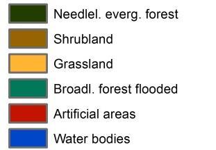
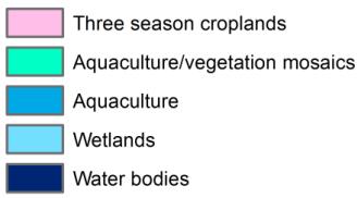
11 The MEKONG LC2010 land cover map Slide Folie # 13 13

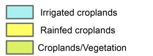
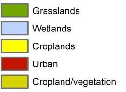
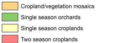
12 Land cover comparison for the Mekong Delta MEKONG LC 2010 GlobCover 2009 MODIS Land Cover 2009 Slide Folie # 14 14


13 Subpixel land cover estimation for High resolution Satellite data Reflectance Land cover proportions Forest Woodland Classification Aggregation to subpixel land cover proportion MODIS Reflectance Phenology Regression Model Cropland Tree Density Slide Folie # 15 15

 Slide Folie #")
14 Detection of land cover changes Temporary forest cut (shifting cultivation) Permanent forest cut (large plantation) Slide Folie # 17 17
15 Conclusion and Outlook Clear-sky surface reflectance composites were generated by combining satellite data from two platforms and the application of enhanced cloud masks Phenology of the land surface was characterised for the entire Mekong Basin based on EVI time series for A comprehensive land cover map was derived based on spectral and temporal information for the year Subpixel land cover proportions and continuous fields of tree density was estimated for the time period Still to do: Detecting different types (temporary/permanent, gradual/abrupt) of land cover change Spatio-temporal analyses of land cover changes (relating change to population density, distance to infrastructure/settlements etc.) Introduction > Compositing > Phenology > Land Cover 2010 > Land Cover dynamics > Conclusion Slide Folie # 18 18
16 Thank you for your attention! Folie 19
Cross-Sensor Continuity Science Algorithm
 Cross-Sensor Continuity Science Algorithm - Long Term Vegetation Index and Phenology Workshop - Javzan Tsend-Ayush and Tomoaki Miura Department of Natural Resources and Environmental Management University
Comparison of NASA AIRS and MODIS Land Surface Temperature and Infrared Emissivity Measurements from the EOS AQUA platform
 Comparison of NASA AIRS and MODIS Land Surface Temperature and Infrared Emissivity Measurements from the EOS AQUA platform Robert Knuteson, Hank Revercomb, Dave Tobin University of Wisconsin-Madison 16
Comparison of NASA AIRS and MODIS Land Surface Temperature and Infrared Emissivity Measurements from the EOS AQUA platform
 Comparison of NASA AIRS and MODIS Land Surface Temperature and Infrared Emissivity Measurements from the EOS AQUA platform Robert Knuteson, Steve Ackerman, Hank Revercomb, Dave Tobin University of Wisconsin-Madison
AGOG 485/585 /APLN 533 Spring Lecture 5: MODIS land cover product (MCD12Q1). Additional sources of MODIS data
. Additional sources of MODIS data") AGOG 485/585 /APLN 533 Spring 2019 Lecture 5: MODIS land cover product (MCD12Q1). Additional sources of MODIS data Outline Current status of land cover products Overview of the MCD12Q1 algorithm Mapping
AGOG 485/585 /APLN 533 Spring 2019 Lecture 5: MODIS land cover product (MCD12Q1). Additional sources of MODIS data Outline Current status of land cover products Overview of the MCD12Q1 algorithm Mapping
Implementation of the NCEP operational GLDAS for the CFS land initialization
 Implementation of the NCEP operational GLDAS for the CFS land initialization Jesse Meng, Mickael Ek, Rongqian Yang NOAA/NCEP/EMC July 2012 1 Improving the Global Land Surface Climatology via improved Global
A new land cover map for the Mekong: Southeast Asia s largest transboundary river basin
 A new land cover map for the Mekong: Southeast Asia s largest transboundary river basin Patrick Leinenkugel 1, Natascha Oppelt 2, Claudia Kuenzer 1 German Aerospace Center (DLR), German Remote Sensing
Capabilities and Limitations of Land Cover and Satellite Data for Biomass Estimation in African Ecosystems Valerio Avitabile
 Capabilities and Limitations of Land Cover and Satellite Data for Biomass Estimation in African Ecosystems Valerio Avitabile Kaniyo Pabidi - Budongo Forest Reserve November 13th, 2008 Outline of the presentation
Module 2.1 Monitoring activity data for forests using remote sensing
 Module 2.1 Monitoring activity data for forests using remote sensing Module developers: Frédéric Achard, European Commission (EC) Joint Research Centre (JRC) Jukka Miettinen, EC JRC Brice Mora, Wageningen
Changes in Seasonal Albedo with Land Cover Class
 Name: Date: Changes in Seasonal Albedo with Land Cover Class Guiding question: How does albedo change over the seasons in different land cover classes? Introduction. Now that you have completed the Introduction
First steps toward a comparison of modelled thermal comfort during a heatwave in Melbourne, Australia
 First steps toward a comparison of modelled thermal comfort during a heatwave in Melbourne, Australia Stephanie Jacobs PhD supervisors: Ailie Gallant and Nigel Tapper Outline of talk Motivation for research
Application and impacts of the GlobeLand30 land cover dataset on the Beijing Climate Center Climate Model
 IOP Conference Series: Earth and Environmental Science PAPER OPEN ACCESS Application and impacts of the GlobeLand30 land cover dataset on the Beijing Climate Center Climate Model To cite this article:
DEVELOPMENT OF GPS PHOTOS DATABASE FOR LAND USE AND LAND COVER APPLICATIONS
 DEVELOPMENT OF GPS PHOTOS DATABASE FOR LAND USE AND LAND COVER APPLICATIONS An Ngoc VAN and Wataru TAKEUCHI Institute of Industrial Science University of Tokyo 4-6-1 Komaba, Meguro-ku, Tokyo 153-8505 Japan
Assimilating terrestrial remote sensing data into carbon models: Some issues
 University of Oklahoma Oct. 22-24, 2007 Assimilating terrestrial remote sensing data into carbon models: Some issues Shunlin Liang Department of Geography University of Maryland at College Park, USA Sliang@geog.umd.edu,
Dynamic Land Cover Dataset Product Description
 Dynamic Land Cover Dataset Product Description V1.0 27 May 2014 D2014-40362 Unclassified Table of Contents Document History... 3 A Summary Description... 4 Sheet A.1 Definition and Usage... 4 Sheet A.2
Estimation of evapotranspiration using satellite TOA radiances Jian Peng
 Estimation of evapotranspiration using satellite TOA radiances Jian Peng Max Planck Institute for Meteorology Hamburg, Germany Satellite top of atmosphere radiances Slide: 2 / 31 Surface temperature/vegetation
Using VIIRS Land Surface Temperature to Evaluate NCEP North American Mesoscale Model (NAM) Forecast
 Forecast") Using VIIRS Land Surface Temperature to Evaluate NCEP North American Mesoscale Model (NAM) Forecast Zhuo Wang (University of Maryland) Yunyue Yu (NOAA/NESDIS/STAR) Peng Yu (University of Maryland) Yuling
Using VIIRS Land Surface Temperature to Evaluate NCEP North American Mesoscale Model (NAM) Forecast Zhuo Wang (University of Maryland) Yunyue Yu (NOAA/NESDIS/STAR) Peng Yu (University of Maryland) Yuling
Overlay Analysis II: Using Zonal and Extract Tools to Transfer Raster Values in ArcMap
 Overlay Analysis II: Using Zonal and Extract Tools to Transfer Raster Values in ArcMap Created by Patrick Florance and Jonathan Gale, Edited by Catherine Ressijac on March 26, 2018 If you have raster data
WaMaPro a user friendly tool for water surface derivation from SAR data and further products derived from optical data
 WaMaPro a user friendly tool for water surface derivation from SAR data and further products derived from optical data J. Huth a, M. Ahrens a, I. Klein a, U. Gessner a, J. Hoffmann b, C. Kuenzer a a German
ESA-GLOBCOVER - A Global Land Cover Service at 300 m from ENVISAT MERIS Time Series
 October 15, 2008 (Jena Germany) ESA-GLOBCOVER - A Global Land Cover Service at 300 m from ENVISAT MERIS Time Series Defourny P.1, Bontemps S., Vancutsem C.1, Pekel J.F.1,, Vanbogaert E.1, Bicheron P.2,
ANALYSIS AND VALIDATION OF A METHODOLOGY TO EVALUATE LAND COVER CHANGE IN THE MEDITERRANEAN BASIN USING MULTITEMPORAL MODIS DATA
 PRESENT ENVIRONMENT AND SUSTAINABLE DEVELOPMENT, NR. 4, 2010 ANALYSIS AND VALIDATION OF A METHODOLOGY TO EVALUATE LAND COVER CHANGE IN THE MEDITERRANEAN BASIN USING MULTITEMPORAL MODIS DATA Mara Pilloni
Classification Techniques with Applications in Remote Sensing
 Classification Techniques with Applications in Remote Sensing Hunter Glanz California Polytechnic State University San Luis Obispo November 1, 2017 Glanz Land Cover Classification November 1, 2017 1 /
Comparison of MSG-SEVIRI and SPOT-VEGETATION data for vegetation monitoring over Africa
 Comparison of MSG-SEVIRI and SPOT-VEGETATION data for vegetation monitoring over Africa Bernard LACAZE CNRS UMR 8586 PRODIG Pôle Image et Campus Spatial, Université Paris Diderot Paris 7 Objectives Comparison
Land biosphere atmosphere interactions over the Tibetan plateau from MODIS observations
 Environmental Research Letters LETTER Land biosphere atmosphere interactions over the Tibetan plateau from MODIS observations To cite this article: Menglin S Jin and Terrence J Mullens 2012 Environ. Res.
An Internet-based Agricultural Land Use Trends Visualization System (AgLuT)
") An Internet-based Agricultural Land Use Trends Visualization System (AgLuT) Second half yearly report 01-01-2001-06-30-2001 Prepared for Missouri Department of Natural Resources Missouri Department of
An Internet-based Agricultural Land Use Trends Visualization System (AgLuT) Second half yearly report 01-01-2001-06-30-2001 Prepared for Missouri Department of Natural Resources Missouri Department of
Land cover research, applications and development needs in Slovakia
 Land cover research, applications and development needs in Slovakia Andrej Halabuk Institute of Landscape Ecology Slovak Academy of Sciences (ILE SAS) Štefánikova 3, 814 99 Bratislava, Slovakia Institute
Overview on Land Cover and Land Use Monitoring in Russia
 Russian Academy of Sciences Space Research Institute Overview on Land Cover and Land Use Monitoring in Russia Sergey Bartalev Joint NASA LCLUC Science Team Meeting and GOFC-GOLD/NERIN, NEESPI Workshop
Mongolian Academy of Sciences
 Mongolian Academy of Sciences Figure 5. Change of subsurface profile temperature at some observation well in Jakarta. Figure 6. Change of air temperature in Jakarta in the period of 100 years (KLH, BMG,
Meteorology. Chapter 15 Worksheet 1
 Chapter 15 Worksheet 1 Meteorology Name: Circle the letter that corresponds to the correct answer 1) The Tropic of Cancer and the Arctic Circle are examples of locations determined by: a) measuring systems.
Data Fusion and Multi-Resolution Data
 Data Fusion and Multi-Resolution Data Nature.com www.museevirtuel-virtualmuseum.ca www.srs.fs.usda.gov Meredith Gartner 3/7/14 Data fusion and multi-resolution data Dark and Bram MAUP and raster data Hilker
Dataset Information: Land Cover. Title. Abstract. Supplemental. International Standards. Creation Date Last Update Data Type.
 Dataset Information: Land Cover Title Abstract Supplemental International Standards Land Cover The FAOSTAT Agri Environmental Indicators Land Cover domain contains data on area by land cover class, by
Copernicus for Statistics
 Copernicus for Statistics Stephan Arnold Areal statistics, Federal Statistical Office Thomas Wiatr Remote sensing, Federal Agency for Cartography and Geodesy Content Requirements and Setting Eurostat s
Global Land Cover Mapping
 Global Land Cover Mapping and its application in SDGs Prof. Chen Jun 1, Dr. He Chaoying 2 1 National Geomatics Center of China (NGCC) 2 Ministry of Natural Resources, P.R.China May 30, 2018, Copenhagen
Urban Mapping & Change Detection. Sebastian van der Linden Humboldt-Universität zu Berlin, Germany
 Urban Mapping & Change Detection Sebastian van der Linden Humboldt-Universität zu Berlin, Germany Introduction - The urban millennium Source: United Nations Introduction Text Source: Google Earth Introduction
Observing land from space: Interacting with land data from NASA s LP DAAC
 Observing land from space: Interacting with land data from NASA s LP DAAC Danielle Golon Innovate! Inc., contractor to the U.S. Geological Survey (USGS) Earth Resources Observation and Science (EROS) Center
Extent. Level 1 and 2. October 2017
 Extent Level 1 and 2 October 2017 Overview: Extent account 1. Learning objectives 2. Review of Level 0 (5m) 3. Level 1 (Compilers): Concepts (15m) Group exercise and discussion (15m) 4. Level 2 (Data Providers)
Yaneev Golombek, GISP. Merrick/McLaughlin. ESRI International User. July 9, Engineering Architecture Design-Build Surveying GeoSpatial Solutions
 Yaneev Golombek, GISP GIS July Presentation 9, 2013 for Merrick/McLaughlin Conference Water ESRI International User July 9, 2013 Engineering Architecture Design-Build Surveying GeoSpatial Solutions Purpose
LAND COVER CATEGORY DEFINITION BY IMAGE INVARIANTS FOR AUTOMATED CLASSIFICATION
 LAND COVER CATEGORY DEFINITION BY IMAGE INVARIANTS FOR AUTOMATED CLASSIFICATION Nguyen Dinh Duong Environmental Remote Sensing Laboratory Institute of Geography Hoang Quoc Viet Rd., Cau Giay, Hanoi, Vietnam
Inter-annual stability of land cover classification: explorations and improvements
 Boston University OpenBU Theses & Dissertations http://open.bu.edu Boston University Theses & Dissertations 2014 Inter-annual stability of land cover classification: explorations and improvements Abercrombie,
Leveraging Sentinel-1 time-series data for mapping agricultural land cover and land use in the tropics
 Leveraging Sentinel-1 time-series data for mapping agricultural land cover and land use in the tropics Caitlin Kontgis caitlin@descarteslabs.com @caitlinkontgis Descartes Labs Overview What is Descartes
A Comparison of Tropical Rainforest Phenology Retrieved From Geostationary (SEVIRI) and Polar-Orbiting (MODIS) Sensors Across the Congo Basin
 and Polar-Orbiting (MODIS) Sensors Across the Congo Basin") South Dakota State University Open PRAIRIE: Open Public Research Access Institutional Repository and Information Exchange GSCE Faculty Publications Geospatial Sciences Center of Excellence (GSCE) 8-2016
South Dakota State University Open PRAIRIE: Open Public Research Access Institutional Repository and Information Exchange GSCE Faculty Publications Geospatial Sciences Center of Excellence (GSCE) 8-2016
Land Cover Project ESA Climate Change Initiative. Processing chain for land cover maps dedicated to climate modellers.
 Land Cover Project ESA Climate Change Initiative Processing chain for land cover maps dedicated to climate modellers land_cover_cci S. Bontemps 1, P. Defourny 1, V. Kalogirou 2, F.M. Seifert 2 and O. Arino
Global land cover mapping GLCNMO and data sharing system CEReS Gaia
 Global land cover mapping GLCNMO and data sharing system CEReS Gaia Ryutaro Tateishi Center for Environmental Remote Sensing(CEReS) Chiba University E-mail: tateishi@faculty.chiba-u.jp Production of 500
Building a validation database for land cover products from high spatial resolution images
 Building a validation database for land cover products from high spatial resolution images The Land Cover project of the ESA Climate Change Initiative Bontemps Sophie 1, Achard Frédéric 2, Lamarche Céline
Land accounting in Québec: Pilot project for a sub-provincial area
 Land accounting in Québec: Pilot project for a sub-provincial area Stéphanie Uhde 8th meeting of the London Group on Environmental Accounting Ottawa, 2 October, 2012 Province of Québec Area: 1 667 441
Agro Ecological Malaria Linkages in Uganda, A Spatial Probit Model:
 Agro Ecological Malaria Linkages in Uganda, A Spatial Probit Model: IFPRI Project Title: Environmental management options and delivery mechanisms to reduce malaria transmission in Uganda Spatial Probit
LAND COVER / LAND USE MAP OF GERMANY BASED ON MERIS FULL RESOLUTION DATA
 LAND COVER / LAND USE MAP OF GERMANY BASED ON MERIS FULL RESOLUTION DATA U. Geßner (1), K. P. Günther (2), S. W. Maier (3) (1) German Aerospace Center (DLR) German Remote Sensing Data Center (DFD) Münchnerstraße
MAPPING LAND USE/ LAND COVER OF WEST GODAVARI DISTRICT USING NDVI TECHNIQUES AND GIS Anusha. B 1, Sridhar. P 2
 MAPPING LAND USE/ LAND COVER OF WEST GODAVARI DISTRICT USING NDVI TECHNIQUES AND GIS Anusha. B 1, Sridhar. P 2 1 M. Tech. Student, Department of Geoinformatics, SVECW, Bhimavaram, A.P, India 2 Assistant
Land cover/land use mapping and cha Mongolian plateau using remote sens. Title. Author(s) Bagan, Hasi; Yamagata, Yoshiki. Citation Japan.
 Bagan, Hasi; Yamagata, Yoshiki. Citation Japan.") Title Land cover/land use mapping and cha Mongolian plateau using remote sens Author(s) Bagan, Hasi; Yamagata, Yoshiki International Symposium on "The Imp Citation Region Specific Systems". 6 Nove Japan.
Title Land cover/land use mapping and cha Mongolian plateau using remote sens Author(s) Bagan, Hasi; Yamagata, Yoshiki International Symposium on "The Imp Citation Region Specific Systems". 6 Nove Japan.
Methods review for the Global Land Cover 2000 initiative Presentation made by Frédéric Achard on November 30 th 2000
 Methods review for the Global Land Cover 2000 initiative Presentation made by Frédéric Achard on November 30 th 2000 1. Contents Objectives Specifications of the GLC-2000 exercise Strategy for the analysis
Seasonal and interannual relations between precipitation, soil moisture and vegetation in the North American monsoon region
 Seasonal and interannual relations between precipitation, soil moisture and vegetation in the North American monsoon region Luis A. Mendez-Barroso 1, Enrique R. Vivoni 1, Christopher J. Watts 2 and Julio
Using Time Series Segmentation for Deriving Vegetation Phenology Indices from MODIS NDVI Data
 2010 IEEE International Conference on Data Mining Workshops Using Time Series Segmentation for Deriving Vegetation Phenology Indices from MODIS NDVI Data Varun Chandola, Dafeng Hui, Lianhong Gu, Budhendra
Using MERIS and MODIS for Land Cover Mapping in the Netherlands
 Using MERIS and for Land Cover Mapping in the Netherlands Raul Zurita Milla, Michael Schaepman and Jan Clevers Wageningen University, Centre for Geo-Information, NL Introduction Actual and reliable information
Monitoring Land Cover and Land Use in Central Asia Remote Sensing Contributions from selected German projects
 Monitoring Land Cover and Land Use in Central Asia Remote Sensing Contributions from selected German projects NASA LCLUC Meeting, Tashkent, 11.-13.11.2013 Christopher Conrad University of Würzburg, Institute
Object based modelling of habitats with EO data: Semantic and technical challenges to achieve interoperability
 Object based modelling of habitats with EO data: Semantic and technical challenges to achieve interoperability Michael Bock, DLR Space Agency 1.07.2010 Folie 1 Vortrag > Autor > Dokumentname > 09.11.2005
Impact of land cover uncertainties on estimates of biospheric carbon fluxes
 Click Here for Full Article GLOBAL BIOGEOCHEMICAL CYCLES, VOL. 22,, doi:10.1029/2007gb003097, 2008 Impact of land cover uncertainties on estimates of biospheric carbon fluxes T. Quaife, 1,2 S. Quegan,
Global Biogeography. Natural Vegetation. Structure and Life-Forms of Plants. Terrestrial Ecosystems-The Biomes
 Global Biogeography Natural Vegetation Structure and Life-Forms of Plants Terrestrial Ecosystems-The Biomes Natural Vegetation natural vegetation is the plant cover that develops with little or no human
Our climate system is based on the location of hot and cold air mass regions and the atmospheric circulation created by trade winds and westerlies.
 CLIMATE REGIONS Have you ever wondered why one area of the world is a desert, another a grassland, and another a rainforest? Or have you wondered why are there different types of forests and deserts with
Aggregation of Sentinel-2 time series classifications as a solution for multitemporal analysis
 Aggregation of Sentinel-2 time series classifications as a solution for multitemporal analysis Stanisław Lewiński* a, Artur Nowakowski a, Radek Malinowski a, Marcin Rybicki a, Ewa Kukawska a, Michał Krupiński
remote sensing ISSN
 Remote Sens. 2014, 6, 8594-8616; doi:10.3390/rs6098594 Article OPEN ACCESS remote sensing ISSN 2072-4292 www.mdpi.com/journal/remotesensing Inter-Calibration of Satellite Passive Microwave Land Observations
Geospatial technology for land cover analysis
 Home Articles Application Environment & Climate Conservation & monitoring Published in : Middle East & Africa Geospatial Digest November 2013 Lemenkova Polina Charles University in Prague, Faculty of Science,
Monitoring daily evapotranspiration in the Alps exploiting Sentinel-2 and meteorological data
 Monitoring daily evapotranspiration in the Alps exploiting Sentinel-2 and meteorological data M. Castelli, S. Asam, A. Jacob, M. Zebisch, and C. Notarnicola Institute for Earth Observation, Eurac Research,
Assessing and Improving the Reliability of Volunteered Land Cover Reference Data
 remote sensing Article Assessing and Improving the Reliability of Volunteered Land Cover Reference Data Yuanyuan Zhao 1, Duole Feng 1, Le Yu 1 ID, Linda See 2 ID, Steffen Fritz 2, Christoph Perger 2 ID
Land Monitoring Core Service Implementation Group (LMCS IG) - Results and Outlook
 - Results and Outlook") Land Monitoring Core Service Implementation Group (LMCS IG) - Results and Outlook Pr. Dietmar Grünreich, President of BKG, Germany Chairman of the GMES LMCS IG Outline 1 Introduction 2 Preparatory Projects
Land Monitoring Core Service Implementation Group (LMCS IG) - Results and Outlook Pr. Dietmar Grünreich, President of BKG, Germany Chairman of the GMES LMCS IG Outline 1 Introduction 2 Preparatory Projects
Calculating Drive-time Buffers and Territories with Sparse Road Network
 Calculating Drive-time Buffers and Territories with Sparse Road Network Ran Tao 1, Jean-Claude Thill 1, James Walsh 1 Daniel Strandow 2, Michael Findley 3 1 University of North Carolina at Charlotte 2
Note: This validation is designed to test the accuracy of the mapping process (i.e. the map models) not the accuracy of the map itself.
 not the accuracy of the map itself.") Ecological Classes and Criteria for Assigning Fuzzy Set Values Fuzzy set validation assessment is being used to evaluate land cover mapping by comparing the label of reference point to map. The validation
Ecological Classes and Criteria for Assigning Fuzzy Set Values Fuzzy set validation assessment is being used to evaluate land cover mapping by comparing the label of reference point to map. The validation
Spanish national plan for land observation: new collaborative production system in Europe
 ADVANCE UNEDITED VERSION UNITED NATIONS E/CONF.103/5/Add.1 Economic and Social Affairs 9 July 2013 Tenth United Nations Regional Cartographic Conference for the Americas New York, 19-23, August 2013 Item
Climate: long term average weather. Use climograph to display climate data. Climograph
 March 27, 2014: Introduction to climate. If you have not yet taken Exam 1 or Exam 2, please email me to set up a time to take a makeup. All makeup exams should be completed before taking Exam 3. Climate:
Weather and climate outlooks for crop estimates
 Weather and climate outlooks for crop estimates CELC meeting 2016-04-21 ARC ISCW Observed weather data Modeled weather data Short-range forecasts Seasonal forecasts Climate change scenario data Introduction
CadasterENV Sweden Time series in support of a multi-purpose land cover mapping system at national scale
 CadasterENV Sweden Time series in support of a multi-purpose land cover mapping system at national scale Mats Rosengren, Camilla Jönsson ; Metria AB Marc Paganini ; ESA ESRIN Background CadasterENV Sweden
Development of high resolution land surface parameters for the Community Land Model
 doi:10.5194/gmd-5-1341-2012 Author(s) 2012. CC Attribution 3.0 License. Geoscientific Model Development Development of high resolution land surface parameters for the Community Land Model Y. Ke 1,2, L.
Regionalization of the IGBP Global Land Cover Map for Western Africa (Ghana, Togo and Benin)
") Regionalization of the IGBP Global Land Cover Map for Western Africa (Ghana, Togo and Benin) G. Menz Remote Sensing Research Group, Department of Geography, University of Bonn, Germany M. Bethke Remote
Regionalization of the IGBP Global Land Cover Map for Western Africa (Ghana, Togo and Benin) G. Menz Remote Sensing Research Group, Department of Geography, University of Bonn, Germany M. Bethke Remote
Global land cover mapping from MODIS: algorithms and early results
 Remote Sensing of Environment 83 (2002) 287 302 www.elsevier.com/locate/rse Global land cover mapping from MODIS: algorithms and early results M.A. Friedl a, *, D.K. McIver a, J.C.F. Hodges a, X.Y. Zhang
Yan Chen, Sunny Sun-Mack, and Robert F. Arduini Science Application International Corporation, Hampton, VA USA 23666
 5.6 CLEAR-SKY AND SURFACE NARROWBAND ALBEDO VARIATIONS DERIVED FROM VIRS AND MODIS DATA Yan Chen, Sunny Sun-Mack, and Robert F. Arduini Science Application International Corporation, Hampton, VA USA 23666
Watershed Classification with GIS as an Instrument of Conflict Management in Tropical Highlands of the Lower Mekong Basin
 Page 1 of 8 Watershed Classification with GIS as an Instrument of Conflict Management in Tropical Highlands of the Lower Mekong Basin Project Abstract The University of Giessen is actually planning a research
Chapter 7 Part III: Biomes
 Chapter 7 Part III: Biomes Biomes Biome: the major types of terrestrial ecosystems determined primarily by climate 2 main factors: Temperature and precipitation Depends on latitude or altitude; proximity
16 Global Climate. Learning Goals. Summary. After studying this chapter, students should be able to:
 16 Global Climate Learning Goals After studying this chapter, students should be able to: 1. associate the world s six major vegetation biomes to climate (pp. 406 408); 2. describe methods for classifying
Name Hour. Chapter 4 Review
 Name Hour Chapter 4 Review 1. The average, year-after-year conditions of temperature and precipitation within a particular region are its weather. climate. greenhouse effect. d. biotic factors. 2. The
Overview of Remote Sensing in Natural Resources Mapping
 Overview of Remote Sensing in Natural Resources Mapping What is remote sensing? Why remote sensing? Examples of remote sensing in natural resources mapping Class goals What is Remote Sensing A remote sensing
Application of Pattern Recognition and Adaptive DSP Methods for Spatio-temporal Analysis of Satellite Based Hydrological Datasets
 Application of Pattern Recognition and Adaptive DSP Methods for Spatio-temporal Analysis of Satellite Based Hydrological Datasets Anish Chand Turlapaty DISSERTATION.COM Boca Raton Application of Pattern
Validation of NOAA Interactive Snow Maps in the North American region with National Climatic Data Center Ground-based Data
 City University of New York (CUNY) CUNY Academic Works Master's Theses City College of New York 2011 Validation of NOAA Interactive Snow Maps in the North American region with National Climatic Data Center
Droughts are normal recurring climatic phenomena that vary in space, time, and intensity. They may affect people and agriculture at local scales for
 I. INTRODUCTION 1.1. Background Droughts are normal recurring climatic phenomena that vary in space, time, and intensity. They may affect people and agriculture at local scales for short periods or cover
Evaluation of updated JXAM5 snow cover extent product using ground based snow depth information
 2 nd International Satellite Snow Product Intercomparison Workshop ISSPI-2 University Memorial Center (UMC), University of Colorado Boulder, 14-16 September 2015 Evaluation of updated JXAM5 snow cover
Introduction to risk assessment
 Introduction to risk assessment Inception workshop of the project Strengthening the regional preparedness, prevention and response against lumpy skin disease in Belarus, Moldova and Ukraine (TCP/RER/3605)
VIC Hydrology Model Training Workshop Part II: Building a model
 VIC Hydrology Model Training Workshop Part II: Building a model 11-12 Oct 2011 Centro de Cambio Global Pontificia Universidad Católica de Chile Ed Maurer Civil Engineering Department Santa Clara University
Appendix E: Cowardin Classification Coding System
 Appendix E: Cowardin Classification Coding System The following summarizes the Cowardin classification coding system and the letters and numbers used to define the USFWS NWI wetland types and subtypes:
PYROGEOGRAPHY OF THE IBERIAN PENINSULA
 PYROGEOGRAPHY OF THE IBERIAN PENINSULA Teresa J. Calado (1), Carlos C. DaCamara (1), Sílvia A. Nunes (1), Sofia L. Ermida (1) and Isabel F. Trigo (1,2) (1) Instituto Dom Luiz, Universidade de Lisboa, Lisboa,
Developing a spatially continuous 1 km surface albedo data set over North America from Terra MODIS products
 Click Here for Full Article JOURNAL OF GEOPHYSICAL RESEARCH, VOL. 112,, doi:10.1029/2006jd008377, 2007 Developing a spatially continuous 1 km surface albedo data set over North America from Terra MODIS
JOURNAL OF GEOPHYSICAL RESEARCH, VOL. 110, D01104, doi: /2004jd005190, 2005
 JOURNAL OF GEOPHYSICAL RESEARCH, VOL. 110,, doi:10.1029/2004jd005190, 2005 MODIS bidirectional reflectance distribution function and albedo Climate Modeling Grid products and the variability of albedo
The German GMES extension to support land cover data systems: Status and outlook
 The German GMES extension to support land cover data systems: Status and outlook Bergen, 2nd July 2010 Oliver Buck, EFTAS GmbH Co-Funded by the Federal Ministry of Economics and Technology (BMWi) via the
Predicting ectotherm disease vector spread. - Benefits from multi-disciplinary approaches and directions forward
 Predicting ectotherm disease vector spread - Benefits from multi-disciplinary approaches and directions forward Naturwissenschaften Stephanie Margarete THOMAS, Carl BEIERKUHNLEIN, Department of Biogeography,
CHAPTER-7 INTERFEROMETRIC ANALYSIS OF SPACEBORNE ENVISAT-ASAR DATA FOR VEGETATION CLASSIFICATION
 147 CHAPTER-7 INTERFEROMETRIC ANALYSIS OF SPACEBORNE ENVISAT-ASAR DATA FOR VEGETATION CLASSIFICATION 7.1 INTRODUCTION: Interferometric synthetic aperture radar (InSAR) is a rapidly evolving SAR remote
forest tropical jungle swamp marsh prairie savanna pampas Different Ecosystems (rainforest)
") Different Ecosystems forest A region of land that is covered with many trees and shrubs. tropical jungle (rainforest) swamp A region with dense trees and a variety of plant life. It has a tropical climate.
Different Ecosystems forest A region of land that is covered with many trees and shrubs. tropical jungle (rainforest) swamp A region with dense trees and a variety of plant life. It has a tropical climate.
Comparing different MODIS snow products with distributed simulation of the snowpack in the French Alps
 Comparing different MODIS snow products with distributed simulation of the snowpack in the French Alps Luc Charrois 1, Marie Dumont 1,*, Pascal Sirguey 2, Samuel Morin 1, Matthieu Lafaysse 1 and Fatima
SUPPLEMENTARY INFORMATION
 SUPPLEMENTARY INFORMATION Radiative forcing and albedo feedback from the northern hemisphere cryosphere between 1979 and 2008 M. G. Flanner 1 *, K. M. Shell 2, M. Barlage 3, D. K. Perovich 4, & M. A. Tschudi
Greening of Arctic: Knowledge and Uncertainties
 Greening of Arctic: Knowledge and Uncertainties Jiong Jia, Hesong Wang Chinese Academy of Science jiong@tea.ac.cn Howie Epstein Skip Walker Moscow, January 28, 2008 Global Warming and Its Impact IMPACTS
MAXMISING AUTOMATION IN LAND COVER MONITORING WITH CHANGE DETECTION. 1. Remote Sensing Research Unit, CSIR-Meraka, Pretoria, 0001, South Africa
 MAXMISING AUTOMATION IN LAND COVER MONITORING WITH CHANGE DETECTION Konrad Wessels 1, Frans van den Bergh 1, Karen Steenkamp 1, Derick Swanepoel 1, Bryan McAlister 1, Brian Salmon 1, David Roy 2 and Valeriy
Seasonal Hydrological Forecasting in the Berg Water Management Area of South Africa
 Seasonal Hydrological Forecasting in the Berg Water Management Area of South Africa Trevor LUMSDEN and Roland SCHULZE University of KwaZulu-Natal, South Africa OUTLINE Introduction Objectives Study Area
Global Patterns Gaston, K.J Nature 405. Benefit Diversity. Threats to Biodiversity
 Biodiversity Definitions the variability among living organisms from all sources, including, 'inter alia', terrestrial, marine, and other aquatic ecosystems, and the ecological complexes of which they
A Shape-based Approach to Spatio-Temporal Data Analysis using Satellite Imagery
 A Shape-based Approach to Spatio-Temporal Data Analysis using Satellite Imagery Thesis submitted in partial fulfillment of the requirements for the degree of Master of Science in Computer Science and Engineering
REMOTE SENSING KEY!!
 REMOTE SENSING KEY!! This is a really ugly cover page I m sorry. Name Key. Score / 100 Directions: You have 50 minutes to take this test. You may use a cheatsheet (2 pages), a non-graphing calculator,