Geospatial workflows and potential applications to the Sustainable Development Goals of countries in West Asia
|
|
|
- Shana Foster
- 5 years ago
- Views:
Transcription

1 Geospatial workflows and potential applications to the Sustainable Development Goals of countries in West Asia Ameer Abdulla, PhD Senior Advisor, European Topic Center for Spatial Analysis, Spain Associate Professor, University of Queensland, Australia
2 Main contributors: Ameer Abdulla (ETC-UMA Senior Advisor; Assoc. Prof. GCI,UQ) Dania Abdul Malak (ETC-UMA; Director) Christoph Schröder (ETC-UMA; GIS and Data Specialist) Marco Trombetti (ETC-UMA; Landscape Ecology and Management Specialist)
3 Outline I. Critical role for spatial and temporal information to systematically monitor biodiversity loss and human use II. Clear workflows are essential to develop monitoring frameworks and useful spatial indicators that can pragmatically measure SDGs (land, coastal and marine related) III. National workflows standardize data to develop indicators that allow regional comparability and prioritization of interventions
4 Outline I. Critical role for spatial and temporal information to systematically monitor biodiversity loss and human use II. Clear workflows are essential to develop monitoring frameworks and useful spatial indicators that can pragmatically measure SDGs (land, coastal and marine related) III. National workflows standardize data to develop indicators that allow regional comparability and prioritization of interventions
5 Potential of spatial information to monitor biodiversity loss and human use Monitoring can be done through data coming from observation (inventories, field sampling, field mapping, remote sensing, image interpretation) => precise and standardised modelled data => less precise, used for gap-filling Independently of the source, any type of data generated needs to be validated Stake holders Ground truthing in the field
6 Types of spatial data used for SDG assessments NSDI fundamental layers Topographic reference layer Statistical data with geographic reference Sampling/survey data Modelled data Reporting data Remote sensing data
7 Sampled field data Submerged Aquatic Vegetation
8 Sampled field data Submerged Aquatic Vegetation
9 Sampled field data Submerged Aquatic Vegetation
10 Sampled field data Submerged Aquatic Vegetation

11 Sampled field data Submerged Aquatic Vegetation
12 Sampled field data Submerged Aquatic Vegetation

13 Reporting data Species of Conservation Importance

 and at 10km grid level")
14 Disaggregating (sub)national statistics Number of nights spent at hotels (2015) at categorical NUTS 2 level (left) and at 10km grid level (right)


15 Modelled data based on observed data Pollution by maritime transport Effects of underwater noise on marine mammals and collision risk

 due to maritime")
16 Combination of observed & modelled data Invasive Alien Species (IAS) due to maritime transport


17 Modelled data based on national statistics Nutrient Input


18 From local data to global assessment

19 Human Pressure Indicator
20 Developing a Cumulative Impacts Indicator from composite data sets and models
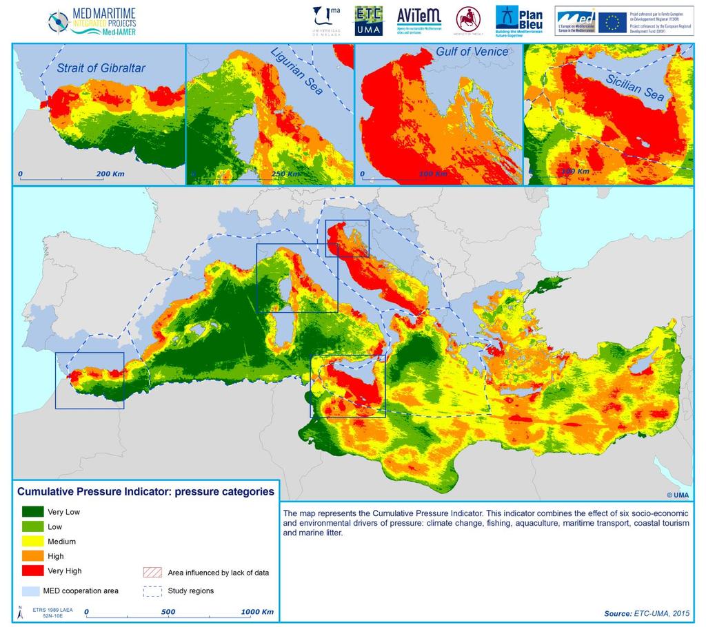
21
22 Outline I. Critical role for spatial and temporal information to systematically monitor biodiversity loss and human use II. Clear workflows are essential to develop monitoring frameworks and useful spatial indicators that can pragmatically measure SDGs (land, coastal and marine related) III. National workflows standardize data to develop indicators that allow regional comparability and prioritization of interventions
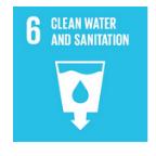
23 A selection of SDG indicators that rely on spatial data Goals and targets (from the 2030 Agenda) 6.6 By 2020, protect and restore water-related ecosystems, including mountains, forests, wetlands, rivers, aquifers and lakes 9.1 Develop quality, reliable, sustainable and resilient infrastructure, including regional and trans-border infrastructure, to support economic development and human well-being, with a focus on affordable and equitable access for all 14.5 By 2020, conserve at least 10 per cent of coastal and marine areas, consistent with national and international law and based on the best available scientific information 15.1 By 2020, ensure the conservation, restoration and sustainable use of terrestrial and inland freshwater ecosystems and their services, in particular forests, wetlands, mountains and drylands, in line with obligations under international agreements 15.3 By 2030, combat desertification, restore degraded land and soil, including land affected by desertification, drought and floods, and strive to achieve a land degradation-neutral world Indicators Change in the extent of water-related ecosystems over time Proportion of the rural population who live within 2 km of an all-season road Coverage of protected areas in relation to marine areas Proportion of important sites for terrestrial and freshwater biodiversity that are covered by protected areas, by ecosystem type Proportion of land that is degraded over total land area
24 A selection of SDG indicators that rely on spatial data Goals and targets (from the 2030 Agenda) 6.6 By 2020, protect and restore water-related ecosystems, including mountains, forests, wetlands, rivers, aquifers and lakes 9.1 Develop quality, reliable, sustainable and resilient infrastructure, including regional and trans-border infrastructure, to support economic development and human well-being, with a focus on affordable and equitable access for all 14.5 By 2020, conserve at least 10 per cent of coastal and marine areas, consistent with national and international law and based on the best available scientific information 15.1 By 2020, ensure the conservation, restoration and sustainable use of terrestrial and inland freshwater ecosystems and their services, in particular forests, wetlands, mountains and drylands, in line with obligations under international agreements 15.3 By 2030, combat desertification, restore degraded land and soil, including land affected by desertification, drought and floods, and strive to achieve a land degradation-neutral world Indicators Change in the extent of water-related ecosystems over time Proportion of the rural population who live within 2 km of an all-season road Coverage of protected areas in relation to marine areas Proportion of important sites for terrestrial and freshwater biodiversity that are covered by protected areas, by ecosystem type Proportion of land that is degraded over total land area
25 SDG indicators will require: 1. RELIABILITY of data sources (official sources, peer-reviewed methodologies, validation, ground truthing) 2. HARMONISATION of data (coming from different sources) and methods 3. REPEATABILITY of methodologies to ensure monitoring of indicators 4. AVAILIBILITY of time series
26 Workflow to develop SDG indicators based on spatial data Data are available at national level and with time series? Yes Are data up-todate, complete & comparable? Yes Are data valid? (validate by stakeholders or groundtruthing) Yes SDG indicator calculation and mapping
27 Workflow to develop SDG indicators based on spatial data Data are available at national level and with time series? No Alternative datasets available? No Use of e.g. remote sensing data Yes Yes Are data up-todate, complete & comparable? At which scale? Local Aggregation to national level Yes Regional Are data valid? (validate by stakeholders or groundtruthing) Disaggregation to national level Yes SDG indicator calculation and mapping
28 Workflow to develop SDG indicators based on spatial data Data are available at national level and with time series? No Alternative datasets available? No Use of e.g. remote sensing data Yes Yes Are data up-todate, complete & comparable? No Improvement with alternative datasets At which scale? Local Aggregation to national level Yes Regional Are data valid? (validate by stakeholders or groundtruthing) Disaggregation to national level Yes SDG indicator calculation and mapping

 No Improvement with alternative datasets Disaggregation to national level Yes Technical")
29 Workflow to develop SDG indicators based on spatial data Data are available at national level and with time series? No Alternative datasets available? No Use of e.g. remote sensing data Yes Yes Are data up-todate, complete & comparable? No Improvement with alternative datasets At which scale? Local Aggregation to national level Yes Regional Are data valid? (validate by stakeholders or groundtruthing) No Improvement with alternative datasets Disaggregation to national level Yes Technical Competence SDG indicator calculation and mapping
30 Outline I. Critical role for spatial and temporal information to systematically monitor biodiversity loss and human use II. Clear workflows are essential to develop monitoring frameworks and useful spatial indicators that can pragmatically measure SDGs (land, coastal and marine related) III. National workflows standardize data to develop indicators that allow regional comparability and prioritization of interventions
31 SDG indicators
32 Workflow to develop SDG indicator based on spatial data Data are available at national level? No Alternative datasets available? No Use of remote sensing data Yes Yes Are data up-todate, complete & comparable? No Improvement with alternative datasets At which scale? Local Aggregation to national level Yes Regional Are data valid (validation by stakeholders)? No Improvement with alternative datasets Disaggregation to national level Yes SDG indicator calculation and mapping

33 Satellite-based coastal wetland monitoring Landsat TM

34 Satellite-based wetland monitoring
35
36
37
38


39 Aggregation of site data to national extent data Source: MWO 2012
40 SDG indicators
41 Workflow to develop SDG indicator based on spatial data Data are available at national level? No Alternative datasets available? No Use of remote sensing data Yes Yes Are data up-todate, complete & comparable? No Improvement with alternative datasets At which scale? Local Aggregation to national level Yes Regional Are data valid (validation by stakeholders)? No Improvement with alternative datasets Disaggregation to national level Yes SDG indicator calculation and mapping

42 Marine Protection 2007
")
43 Marine Protection 2014 MAPAMed 2014 update (source: Rodriguez-Rodriguez et al., 2016)
44 Rodríguez-Rodríguez et al Marine protected areas and fishing reserves in the Mediterranean: assessing actual marine biodiversity protection at multiple scales.
45 Marine Protection in km 2 MAPAMed 2014 update (source: Rodriguez-Rodriguez et al., 2016) km
46 Marine Protection in km 2 MAPAMed 2014 update (source: Rodriguez-Rodriguez et al., 2016) CBD Aichi Target 11 and SDG 14.5 of 10% EEZ Conservation Monaco 100% France 59.19% Spain 11.82% Turkey 10.29% Italy 8.55% Croatia 8.48% km 2 0 Morocco 1.68% Tunis 0.90% Egypt 0.57% Syria 0.61%, 0.10% Libya 0.08% Lebanon 0.02%
 Turkey 3% (10.29%) Italy 8% (8.55%) Croatia 0.8% (8.48%) km 2 0 Morocco 1.28 (1.68%) Tunis 0.35% (0.90%) Egypt 0.57% (0.57%) Syria 0.10% (0.10%) Libya 0.08% (0.08%) 5000 4000 3000 Lebanon 0.")
47 Marine Protection in km 2 MAPAMed 2014 update (source: Rodriguez-Rodriguez et al., 2016) Actual Management Monaco 100% (100%) France 55% (59.19%) Spain 2.3% (11.82%) Turkey 3% (10.29%) Italy 8% (8.55%) Croatia 0.8% (8.48%) km 2 0 Morocco 1.28 (1.68%) Tunis 0.35% (0.90%) Egypt 0.57% (0.57%) Syria 0.10% (0.10%) Libya 0.08% (0.08%) Lebanon 0.02% (0.02%)
48 SDG indicators
49 Land degradation Soil sealing Erosion Compaction Loss of soil organic carbon Contamination with pollutants Nutrient surplus/over-fertilisation Loss of soil biodiversity Desertification Salinisation Acidification Landslides Harmonized World Soil Database IIASA- FAO-JRC ISRIC World Soil Information Soil Geographical Database for Eurasia & The Mediterranean, JRC-INRA Digital Soil Map of the World, DSMW, FAO Remote-Sensing based data (Copernicus)

50 Land degradation A product like the Soil Water Index, which quantifies the moisture conditions at various depth in soil, can be analyzed over a time series to assess potential patterns of desertification and hence land degradation.
51 Workflow to develop SDG indicator based on spatial data Data are available at national level? No Alternative datasets available? No Use of remote sensing data Yes Yes Are data up-todate, complete & comparable? No Improvement with alternative datasets At which scale? Local Aggregation to national level Yes Regional Are data valid (validation by stakeholders)? No Improvement with alternative datasets Disaggregation to national level Yes SDG indicator calculation and mapping
52 Simplified approach to SDG15
53 Simplified approach to SDG15
54 Main Messages I. Critical role for spatial and temporal information to systematically monitor biodiversity loss and human use II. Clear workflows are essential to develop monitoring frameworks and useful spatial indicators that can pragmatically measure SDGs (land, coastal and marine related) III. National workflows standardize data to develop indicators that allow regional comparability and prioritization of interventions

55 Spatial data survey
56 Spatial data survey The survey aims to gather information about the availability and accessibility of relevant sources of spatial data for environmental SDG indicator reporting and monitoring. A) Data availability for environmental SDG monitoring to understand which specific spatial datasets are available at your organization and, if yes, details about each dataset. Population, human settlements and infrastructure Land use and land cover Biodiversity Water Air quality Marine environment Data owner, data holder Data format, spatial coverage, spatial and temporal resolution Data access
57 Spatial data survey The survey aims to gather information about the availability and accessibility of relevant sources of spatial data for environmental SDG indicator reporting and monitoring. B) Data needs and data gaps: section where you can indicate what data is missing to comply with the environmental SDG monitoring obligations. C) Spatial data analysis, management and storage capacities assesses the capacities and knowledge available at your organization to use spatial data and tools.
 Feedback and data integrated 5) Report on Proposed National Workflow developed by ETC-UMA and")
58 Spatial data survey Roadmap for the Workflow 1) Collection of responses 2) Analysis and synthesis of results 3) Preparation and organisation of national workshop: Discussion of results Data exchange Proposal for workflows 4) Feedback and data integrated 5) Report on Proposed National Workflow developed by ETC-UMA and UNESCUA
 http://swos-service.eu/ Email contact: Marine.")
59 For more information: (map viewer with Med- IAMER data) contact:
Progress Report. Preamble
 Preamble This report is prepared and submitted to the Inter-agency and Expert Group on Sustainable Development Goal Indicators at its Fifth Meeting held from 28 31 March 2017 in Ottawa, Canada. Background
KENYA NATIONAL BUREAU OF STATISTICS Workshop on
 KENYA NATIONAL BUREAU OF STATISTICS Workshop on Capacity Building in Environment Statistics: the Framework for the Development of Environment Statistics (FDES 2013) Coordination with Sector Ministries
Mapping Water Resources and Reservoirs for Climate Resilience in Zambezi River Basin
 Mapping Water Resources and Reservoirs for Climate Resilience in Zambezi River Basin Corné van der Sande, NEO BV Senior Advisor Earth Observation Services for Monitoring Drought and Water Resources in
EuroGEOSS Protected Areas Pilot
 EuroGEOSS Protected Areas Pilot Max Craglia European Commission Joint Research Centre Part 1: the present MyNatura2000 Mobile app. Awareness raising & volunteered data collection. Natura2000 covers 18%
Accounting for Ecosystem and Biodiversity Related Themes in Uganda
 Introduction Accounting for Ecosystem and Biodiversity Related Themes in Uganda Calls for more evidence-based approaches to policy have increased the need for integrated environmental-economic information
National assessment on member s readiness to produce indicators
 Inter-Agency and Expert Group on the Sustainable Development Goal Indicators WORKING GROUP ON GEOSPATIAL INFORMATION Fifth expert meeting 5 and 8 December 2018 8 th Meeting of IAEG-SDGs 5 8 November 2018,
System of Environmental-Economic Accounting. Advancing the SEEA Experimental Ecosystem Accounting. Extent Account (Levels 1 and 2)
") Advancing the SEEA Experimental Ecosystem Accounting Extent Account (Levels 1 and 2) Overview: The Extent Account 1. Learning objectives 2. Review of Level 0 (5m) What is it? Why do we need it? What does
Advancing the SEEA Experimental Ecosystem Accounting Extent Account (Levels 1 and 2) Overview: The Extent Account 1. Learning objectives 2. Review of Level 0 (5m) What is it? Why do we need it? What does
Extent. Level 1 and 2. October 2017
 Extent Level 1 and 2 October 2017 Overview: Extent account 1. Learning objectives 2. Review of Level 0 (5m) 3. Level 1 (Compilers): Concepts (15m) Group exercise and discussion (15m) 4. Level 2 (Data Providers)
Land Accounts - The Canadian Experience
 Land Accounts - The Canadian Experience Development of a Geospatial database to measure the effect of human activity on the environment Who is doing Land Accounts Statistics Canada (national) Component
Compact guides GISCO. Geographic information system of the Commission
 Compact guides GISCO Geographic information system of the Commission What is GISCO? GISCO, the Geographic Information System of the COmmission, is a permanent service of Eurostat that fulfils the requirements
8 th Meeting of IAEG-SDGs 5 8 November 2018, Stockholm, Sweden. Meetings. Report
 Meetings 8 th Meeting of IAEG-SDGs Between April 2018 and November 2018, the Working Group on Geospatial Information of the IAEG- SDGs held two online meetings; presented a report to the United Nations
THE GLOBAL INDICATOR FRAMEWORK: NEW AND INNOVATIVE METHODS FOR DISAGGREGATIN BY GEOLOCATION
 Parallel Session: Measuring and Monitoring the SDGs: THE GLOBAL INDICATOR FRAMEWORK: NEW AND INNOVATIVE METHODS FOR DISAGGREGATIN BY GEOLOCATION from global to regional to national panorama 8 th Meeting
Land Accounting. Sub-regional Workshop on Environment Statistics for South and South-West Asian Countries. Michael Bordt ESCAP
 Land Accounting Michael Bordt ESCAP bordt@un.org Sub-regional Workshop on Environment Statistics for South and South-West Asian Countries Feb. 6-8, 2017 Bangkok, Thailand Overview: Land Accounting Learning
Global Ecosystem Mapping For UN SEEA Ecosystem Accounting
 Global Ecosystem Mapping For UN SEEA Ecosystem Accounting Roger Sayre (U. S. Geological Survey); Dawn Wright, Sean Breyer, Charlie Frye, and others (Esri) UN SEEA Experts Forum on Ocean Ecosystem Accounting
Ecological mapping using satellite imagery: an Abu Dhabi case study Middle East Geospatial Forum 16 th February 2015
 Ecological mapping using satellite imagery: an Abu Dhabi case study Middle East Geospatial Forum 16 th February 2015 Richard Flemmings rf@proteusgeo.com About Proteus Formed in UAE 2011 We specialise in
Resolution XIII.23. Wetlands in the Arctic and sub-arctic
 13th Meeting of the Conference of the Contracting Parties to the Ramsar Convention on Wetlands Wetlands for a Sustainable Urban Future Dubai, United Arab Emirates, 21-29 October 2018 Resolution XIII.23
Work Group A «Core Data» Report and Update François Chirié, Dominique Laurent, France
 JOINT UN-GGIM: EUROPE ESS MEETING ON THE INTEGRATION OF STATISTICAL AND GEOSPATIAL INFORMATION LUXEMBOURG 11 MARCH 2016 Work Group A «Core Data» Report and Update François Chirié, Dominique Laurent, France
SEEA Experimental Ecosystem Accounting
 SEEA Experimental Ecosystem Accounting Sokol Vako United Nations Statistics Division Training for the worldwide implementation of the System of Environmental Economic Accounting 2012 - Central Framework
Relevant data to produce SDG indicators in France
 Working group on Geospatial Information December, 2017 - New-York Relevant data to produce SDG indicators in France Frédéric VEY Office manager -Ministry of ecology and solidarity transition (FRANCE) 2
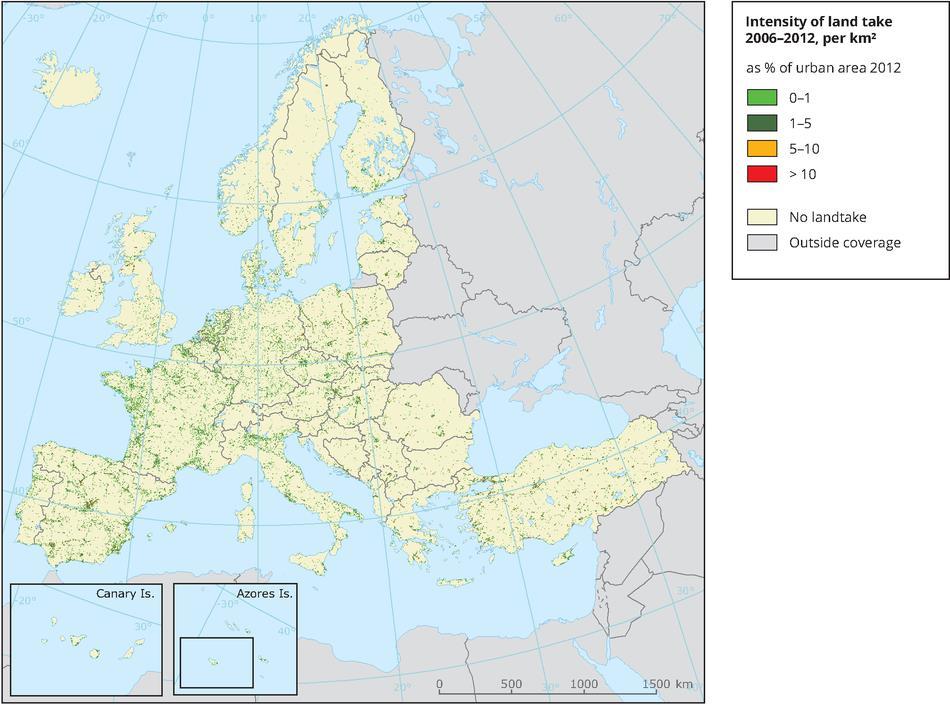
2.- Area of built-up land
 2.- Area of built-up land Key message Over recent decades, built-up areas have been steadily increasing all over Europe. In Western European countries, built-up areas have been increasing faster than the
Biodiversity Blueprint Overview
 Biodiversity Blueprint Overview Climate Variability Climate projections for the Glenelg Hopkins Regions suggest that the weather will be hotter and drier in the coming years which will impact on land use,
I&CLC2000 in support to new policy initiatives (INSPIRE, GMES,..)
") I&CLC2000 in support to new policy initiatives (INSPIRE, GMES,..) Manfred Grasserbauer, Director Joint Research Centre Institute for Environment and Sustainability 1 IMAGE 2000 European mosaic of satellite
I&CLC2000 in support to new policy initiatives (INSPIRE, GMES,..) Manfred Grasserbauer, Director Joint Research Centre Institute for Environment and Sustainability 1 IMAGE 2000 European mosaic of satellite
Directorate E: Sectoral and regional statistics Unit E-4: Regional statistics and geographical information LUCAS 2018.
 EUROPEAN COMMISSION EUROSTAT Directorate E: Sectoral and regional statistics Unit E-4: Regional statistics and geographical information Doc. WG/LCU 52 LUCAS 2018 Eurostat Unit E4 Working Group for Land
Estimation of the area of sealed soil using GIS technology and remote sensing
 From the SelectedWorks of Przemysław Kupidura 2010 Estimation of the area of sealed soil using GIS technology and remote sensing Stanisław Białousz Przemysław Kupidura Available at: https://works.bepress.com/przemyslaw_kupidura/14/
Spanish national plan for land observation: new collaborative production system in Europe
 ADVANCE UNEDITED VERSION UNITED NATIONS E/CONF.103/5/Add.1 Economic and Social Affairs 9 July 2013 Tenth United Nations Regional Cartographic Conference for the Americas New York, 19-23, August 2013 Item
Supporting GPSC Cities with Satellite Earth Observation for Sustainable Urban Development
 Supporting GPSC Cities with Satellite Earth Observation for Sustainable Urban Development Global Platform for Sustainable Cities African Regional Workshop 14 May 2018 AfDB Headquarters Abidjan, Côte d'ivoire
A Data Fusion Approach to Real-time Monitoring Systems and Information Management
 Landslide Preparedness in the ASEAN Member States A Data Fusion Approach to Real-time Monitoring Systems and Information Management Jessada Karnjana, PhD National Electronics and Computer Technology Center
Establishment of the Hellenic Ecosystem Services Partnership (HESP) research group: Drafting the national agenda for the implementation of the
 research group: Drafting the national agenda for the implementation of the") Establishment of the Hellenic Ecosystem Services Partnership (HESP) research group: Drafting the national agenda for the implementation of the ES concept in Greece Establishment of the Hellenic Ecosystem
Establishment of the Hellenic Ecosystem Services Partnership (HESP) research group: Drafting the national agenda for the implementation of the ES concept in Greece Establishment of the Hellenic Ecosystem
THE ROLE OF GEOSPATIAL AT THE WORLD BANK
 THE ROLE OF GEOSPATIAL AT THE WORLD BANK INSPIRE Conference Barcelona, Spain September 26, 2016 Kathrine Kelm Senior Land Administration Specialist Global Land and Geospatial Unit The World Bank Group
SWOS - Satellite-based Wetland Observation Service
 This project has received funding from the European Union s Horizon 2020 research and innovation programme under grant agreement No 642088 SWOS - Satellite-based Wetland Observation Service SWOS at the
Geological information for Europe : Towards a pan-european Geological Data Infrastructure
 Geological information for Europe : Towards a pan-european Geological Data Infrastructure Integrating geoscientific information for EU competitiveness Co-funded by the European Union European societal
Empowered lives. Resilient nations. Data for People and Planet. powered by
 Empowered lives. Resilient nations. Data for People and Planet powered by Overview As we enter the fourth industrial revolution, technology is revolutionizing our ability to map nature. Satellite data
Biodiversity and Ecosystem services Thinking globally, acting locally
 Biodiversity and Ecosystem services Thinking globally, acting locally Anne-Gaelle Ausseil - Manaaki Whenua Landcare Research Geoff Hicks National Commission for UNESCO 1 8 / 1 0 / 2 0 1 8 M A N A A K I
Geographic Information Infrastructure and Policy Framework for Sustainable Mountain Development in the Hindu Kush-Himalayas
 Geo SMART ASIA 2017 22-24 August, Kualalampur Geographic Information Infrastructure and Policy Framework for Sustainable Mountain Development in the Hindu Kush-Himalayas Basanta Shrestha, Director Strategic
Space Application in Support of Land Management for SDG Implementation
 Space Application in Support of Land Management for SDG Implementation Regional Expert Workshop on Land Accounting for SDG Monitoring and Reporting 26 September 2017 Space Application Section Information
Integration for Informed Decision Making
 Geospatial and Statistics Policy Intervention: Integration for Informed Decision Making Greg Scott Global Geospatial Information Management United Nations Statistics Division Department of Economic and
INDICATORS FOR INTEGRATED COASTAL ZONE MANAGEMENT (ICZM)
") IOC UNESCO / Leader Task 4.1 Contact Francesca Santoro, Julian Barbiere E-mail: f.santoro@unesco.org, j.barbiere@unesco.org Phone: +33 1 45683952 How to cite this factsheet: PEGASO Consortium. 2013. Area
IOC UNESCO / Leader Task 4.1 Contact Francesca Santoro, Julian Barbiere E-mail: f.santoro@unesco.org, j.barbiere@unesco.org Phone: +33 1 45683952 How to cite this factsheet: PEGASO Consortium. 2013. Area
CLICK HERE TO KNOW MORE
 CLICK HERE TO KNOW MORE Geoinformatics Applications in Land Resources Management G.P. Obi Reddy National Bureau of Soil Survey & Land Use Planning Indian Council of Agricultural Research Amravati Road,
Space for Sustainable Development
 Space for Sustainable Development ESA s contribution to the Where, What, and How of Data Dr. Christoph Aubrecht Directorate of Earth Observation Programmes Science, Applications and Future Technologies
Geospatial Technologies for Resources Planning & Management
 Geospatial Technologies for Resources Planning & Management Lal Samarakoon, PhD Director, Geoinformatics Center Asian Institute of Technology, Thailand Content Geoinformatics for SDG Information Integration
Country reports. Israel did not establish an Exclusive Economic Zone. Consequently, its jurisdiction is restricted to the Israeli territorial waters.
 Country reports I. ISRAEL Disclaimer This document has not been adopted by the European Commission and should therefore not be relied upon as a statement of the European Commission. The purpose of this
Current LCLUC challenges in SCERIN: Assessing Ecosystem Function and Processes
 Summary of the SCERIN 2 meeting Current LCLUC challenges in SCERIN: Assessing Ecosystem Function and Processes Katarzyna Ostapowicz Department of GIS, Cartography and Remote Sensing, Institute of Geography
Plenary Session 2, part 2 A European shared information system
 3 rd GMES Forum 5 6 June 2003 Athens Plenary Session 2, part 2 A European shared information system Gordon McInnes Deputy Director European Environment Agency 1 I keep six honest serving men. They taught
The Coastal Change Analysis Program and the Land Cover Atlas. Rebecca Love NOAA Office for Coastal Management
 The Coastal Change Analysis Program and the Land Cover Atlas Rebecca Love NOAA Office for Coastal Management Natural Infrastructure = Greater Resilience NOAA C-CAP Regional Land Cover and Change coast.noaa.gov/digitalcoast/data/ccapregional
LUCAS: current product and its evolutions
 LUCAS: current product and its evolutions Workshop Land Use and Land Cover products: challenges and opportunities Brussels 15 Nov 2017 Eurostat E4: estat-dl-lucas@ec.europa.eu Contents 1) The context 2)
IAEG SDGs WG GI, , Mexico City
 IAEG SDGs WG GI, 12-14.12.2016, Mexico City UN-GGIM:Europe s perspective and activities to support better integration of geospatial information and statistics and the UN SDG monitoring Pier-Giorgio Zaccheddu,
Improving rural statistics. Defining rural territories and key indicators of rural development
 Improving rural statistics Defining rural territories and key indicators of rural development Improving rural statistics Improving Rural Statistics In 2016, the Global Strategy to improve Agricultural
GMES Service for Geospatial Reference Data Access (RDA) Covering Areas Outside Europe
 Covering Areas Outside Europe") INSPIRE Conference 2011 Edinburgh 27 June - 1 July GMES Service for Geospatial Reference Data Access (RDA) Covering Areas Outside Europe Andrea Ajmar, Simone Balbo, Piero Boccardo, Simone Dalmasso, Anna
INSPIRE Conference 2011 Edinburgh 27 June - 1 July GMES Service for Geospatial Reference Data Access (RDA) Covering Areas Outside Europe Andrea Ajmar, Simone Balbo, Piero Boccardo, Simone Dalmasso, Anna
BURGAS CASE STUDY: LAND-SEA INTERACTIONS. Dr. Margarita Stancheva
 BURGAS CASE STUDY: LAND-SEA INTERACTIONS Dr. Margarita Stancheva Name of presentation NEED FOR COHERENCE BETWEEN LAND AND SEA ACTIVITIES Name presenter Burgas is the fourth largest city in Bulgaria and
Natura 2000 in the marine environment: state of implementation and next steps
 Life on the blue planet: biodiversity research and the new European marine policies EPBRS European Platform on Biodiversity Research Strategy Porto, Portugal 7-9 November 2007 Natura 2000 in the marine
SIF_7.1_v2. Indicator. Measurement. What should the measurement tell us?
 Indicator 7 Area of natural and semi-natural habitat Measurement 7.1 Area of natural and semi-natural habitat What should the measurement tell us? Natural habitats are considered the land and water areas
GMES and AFRICA Support Programme 1st technical committee meeting
 GMES and AFRICA Support Programme 1st technical committee meeting Developing an Earth Observation Operational Application for Coastal Ecosystems Mapping, Monitoring and Assessment of the Northern African
EU-level landslide susceptibility assessment
 in the context t of the Soil Thematic Strategy t Andreas Günther 1, Miet Van Den Eeckhaut 2, Paola Reichenbach h 3, Javier Hervás 2 & Jean-Philippe Malet 4 1 Federal Institute for Geosciences and Natural
OSS MISSION.
 GEO-CRADLE COORDINATING AND INTEGRATING STATE-OF-THE-ART EARTH OBSERVATION ACTIVITIES IN THE REGION OF NORTH OF AFRICA, MIDDLE EAST, AND BALKANS AND DEVELOPING LINKS WITH GEO RELATED INITIATIVES TOWARD
Maritime Spatial Planning Framework Directive Supported by INSPIRE
 Maritime Spatial Planning Framework Directive Supported by INSPIRE Andrej Abramić, Vanda Nunes de Lima, Paul Smits, Emanuele Bigagli, Chris Schubert European Commission Joint Research Centre Institute
I. LIBYA I.1. COUNTRY CHARACTERISTICS. Country reports
 Country reports I. LIBYA Disclaimer This document has not been adopted by the European Commission and should therefore not be relied upon as a statement of the European Commission. The purpose of this
Experience of Mexico in using GIS and spatial
 Experience of Mexico in using GIS and spatial data as a tool for data integration Francisco Javier Jimenez Nava Deputy General Director of Natural Resources and Environment Outline Introduction National
The Combination of Geospatial Data with Statistical Data for SDG Indicators
 Session x: Sustainable Development Goals, SDG indicators The Combination of Geospatial Data with Statistical Data for SDG Indicators Pier-Giorgio Zaccheddu Fabio Volpe 5-8 December2018, Nairobi IAEG SDG
Disaster Management & Recovery Framework: The Surveyors Response
 Disaster Management & Recovery Framework: The Surveyors Response Greg Scott Inter-Regional Advisor Global Geospatial Information Management United Nations Statistics Division Department of Economic and
A proposal for building an infrastructure for European geospatial statistics. Marie Haldorson, Statistics Sweden Ekkehard Petri, Eurostat
 A proposal for building an infrastructure for European geospatial statistics Marie Haldorson, Statistics Sweden Ekkehard Petri, Eurostat What is geospatial statistics? The location, extent or spatial relations
Data sources and classification for ecosystem accounting g
 Data sources and classification for ecosystem accounting Ken Bagstad 23 February 2015 Wealth Accounting and the Valuation of Ecosystem Services www.wavespartnership.org Data sources and classification
Measuring Disaster Risk for Urban areas in Asia-Pacific
 Measuring Disaster Risk for Urban areas in Asia-Pacific Acknowledgement: Trevor Clifford, Intl Consultant 1 SDG 11 Make cities and human settlements inclusive, safe, resilient and sustainable 11.1: By
EXPERT ANALYSIS ON GEOGRAPHICAL SPECIFICITIES
 EXPERT ANALYSIS ON GEOGRAPHICAL SPECIFICITIES Mountains, Islands and Sparsely Populated Areas Dr. Gilda Carbone 9 Oct 2018 Objectives: to gather basic information from relevant programming documents (PAs,
UN Work on Geospatial Information in Support of Sustainable Development:
 Consultative Meeting on the Implementation Framework for the Environmental Dimension of the 2030 Agenda in the Arab Region Cairo, Egypt, 18-20 Sep 2017 UN Work on Geospatial Information in Support of Sustainable
Data harmonisation aspects in INSPIRE and beyond : use cases at pan-european level
 Data harmonisation aspects in INSPIRE and beyond : use cases at pan-european level Nathalie Delattre, IGN Email: nathalie.delattre@ngi.be INSPIRE data interoperability setting up common data specifications
Motivations, principles and development of a pan-european approach to describe MPA network coherence in Europe s seas
 Motivations, principles and development of a pan-european approach to describe MPA network coherence in Europe s seas G. Mo 1, S. Agnesi 1, J. Reker 2 1 ISPRA (Rome, Italy) & European Topic Center on Inland
CLIMATE RESILIENT ALTITUDINAL GRADIENTS (CRAGs)
") CLIMATE RESILIENT ALTITUDINAL GRADIENTS (CRAGs) BUILDING CLIMATE CHANGE RESILIENCE IN THE KIVU- RUSIZI WATERSHEDS Great Lake Conference Entebbe 2017 Chris Magero WHAT ARE CRAGs? Climate-Resilient Altitudinal
CLIMATE RESILIENT ALTITUDINAL GRADIENTS (CRAGs) BUILDING CLIMATE CHANGE RESILIENCE IN THE KIVU- RUSIZI WATERSHEDS Great Lake Conference Entebbe 2017 Chris Magero WHAT ARE CRAGs? Climate-Resilient Altitudinal
A donor partner view. Olaf Magnus Østensen. 'Modernization of spatial data infrastructure to reduce risks and impacts of floods'
 A donor partner view Olaf Magnus Østensen 'Modernization of spatial data infrastructure to reduce risks and impacts of floods' About the EEA Grants programme http://eeagrants.org/ Beneficiary country Donor
A proposal for building an infrastructure for European geospatial statistics
 A proposal for building an infrastructure for European geospatial statistics Marie Haldorson, Statistics Sweden Ekkehard Petri, Eurostat What is geospatial statistics? The location, extent or spatial relations
Seabed knowledge In support of UN SDGs
 Seabed knowledge In support of UN SDGs Evert Flier Fiskerifaglig forum 2. november 2017 Hydrography & small scale fishing Hydrography in Transition Serving the Maritime Community Hydrography in Transition
Space Applications for Disaster Risk Reduction and Sustainable Development
 Space Applications for Disaster Risk Reduction and Sustainable Development Space Applications Section (SAS) ICT and Disaster Risk Reduction Division (IDD) UNESCAP Contents I. RESAP Activities 2016-2017
Wetland Programmes. Biodiversity assessments in determining wetland conservation priorities: a catchment approach. Dr. Piet-Louis Grundling
 CHIEF DIRECTORATE NATURAL RESOURCE MANAGEMENT PROGRAMMES: Wetland Programmes Biodiversity assessments in determining wetland conservation priorities: a catchment approach Dr. Piet-Louis Grundling Environmental
Geospatial technology for land cover analysis
 Home Articles Application Environment & Climate Conservation & monitoring Published in : Middle East & Africa Geospatial Digest November 2013 Lemenkova Polina Charles University in Prague, Faculty of Science,
Status of implementation of the INSPIRE Directive 2016 Country Fiches. COUNTRY FICHE Croatia
 Status of implementation of the INSPIRE Directive 2016 Country Fiches COUNTRY FICHE Croatia Introduction... 1 1. State of Play... 2 1.1 Coordination... 2 1.2 Functioning and coordination of the infrastructure...
GIS Solutions in Natural Resource Management: Balancing the Technical- Political Equation
 GIS Solutions in Natural Resource Management: Balancing the Technical- Political Equation Stan Morain, Editor SUB Gdttlngen 7 208 520 309 98 A14447 0NW0RD PRESS V? % \
Indicator: Proportion of the rural population who live within 2 km of an all-season road
 Goal: 9 Build resilient infrastructure, promote inclusive and sustainable industrialization and foster innovation Target: 9.1 Develop quality, reliable, sustainable and resilient infrastructure, including
Policy-oriented ES-research in Belgium: progress and prospects
 Policy-oriented ES-research in Belgium: progress and prospects Vilm 12.10.2011 Sander Jacobs 1, Wouter Van Reeth², Jan Staes 1 & Patrick Meire 1 1 University of Antwerp, ecosystem management research group
Summary Description Municipality of Anchorage. Anchorage Coastal Resource Atlas Project
 Summary Description Municipality of Anchorage Anchorage Coastal Resource Atlas Project By: Thede Tobish, MOA Planner; and Charlie Barnwell, MOA GIS Manager Introduction Local governments often struggle
GIS as a tool in flood management
 GIS for the United Nations and the International Community Conference Panel: GIS and Capacity - How Territorial Planning Benefits from Geospatial Information 3-5 April 2012 Geneva, Switzerland GIS as a
Courtesy of Tomi Petr
 Lake Dal, rich in submerged aquatic plants, is threatened by pollution, Kashmir, India Lakes, reservoirs, rivers and streams are important habitats for inland fisheries, but they are threatened by human
Virginia Shoreline Mapping Tools
 Virginia Shoreline Mapping Tools December 15, 2017 Karen Duhring Center for Coastal Resources Management Virginia Institute of Marine Science College of William & Mary Virginia Shoreline Mapping Tools
«Desertification and Drought Monitoring in Arid Tunisia based on Remote Sensing Imagery» Research Undertaken & Case-Studies.
 «Desertification and Drought Monitoring in Arid Tunisia based on Remote Sensing Imagery» Research Undertaken & Case-Studies EU COST Action September 2015, Antalya Turkey Bouajila ESSIFI INSTITUT DES REGIONS
FAO s LAND COVER AND LAND USE ACTIVITIES - UPDATE OCTOBER
 FAO s LAND COVER AND LAND USE ACTIVITIES - UPDATE OCTOBER 1997 - Background There is an increasing need to be able to precisely describe and classify land cover and land uses in order to define sustainable
The Global Statistical Geospatial Framework and the Global Fundamental Geospatial Themes
 The Global Statistical Geospatial Framework and the Global Fundamental Geospatial Themes Sub-regional workshop on integration of administrative data, big data and geospatial information for the compilation
How to make the European landscape climate-change proof for biodiversity? Prof. Paul Opdam
 How to make the European landscape climate-change proof for biodiversity? Prof. Paul Opdam Notions Habitat fragmentation and land use prevent species to respond to climate change Adaptation of the landscape
INSPIRE Basics. Vlado Cetl European Commission Joint Research Centre. https://ec.europa.eu/jrc/
 INSPIRE Basics Vlado Cetl European Commission Joint Research Centre https://ec.europa.eu/jrc/ Serving society Stimulating innovation Supporting legislation Outline SDI? Why European SDI? INSPIRE Policy
The Added Value of Geospatial Data in a Statistical Office. Pedro Diaz Munoz Director Sectoral and Regional Statistics EUROSTAT European Commission
 The Added Value of Geospatial Data in a Statistical Office Pedro Diaz Munoz Director Sectoral and Regional Statistics EUROSTAT European Commission Why integrate Responsibility of all the information we
Copernicus Overview. Major Emergency Management Conference Athlone 2017
 Copernicus Overview Major Emergency Management Conference Athlone 2017 Copernicus is a European programme implemented by the European Commission. The services address six thematic areas: land, marine,
Applying Hazard Maps to Urban Planning
 Applying Hazard Maps to Urban Planning September 10th, 2014 SAKAI Yuko Disaster Management Expert JICA Study Team for the Metro Cebu Roadmap Study on the Sustainable Urban Development 1 Contents 1. Outline
Egypt Public DSS. the right of access to information. Mohamed Ramadan, Ph.D. [R&D Advisor to the president of CAPMAS]
![Egypt Public DSS. the right of access to information. Mohamed Ramadan, Ph.D. [R&D Advisor to the president of CAPMAS]](/thumbs/89/98483713.jpg "Egypt Public DSS. the right of access to information. Mohamed Ramadan, Ph.D. [R&D Advisor to the president of CAPMAS]") Egypt Public DSS ì the right of access to information Central Agency for Public Mobilization and Statistics Arab Republic of Egypt Mohamed Ramadan, Ph.D. [R&D Advisor to the president of CAPMAS] Egypt
Egypt Public DSS ì the right of access to information Central Agency for Public Mobilization and Statistics Arab Republic of Egypt Mohamed Ramadan, Ph.D. [R&D Advisor to the president of CAPMAS] Egypt
Global reviews of wetland inventory, classification and delineation
 Max Finlayson Institute for Land, Water & Society Charles Sturt University Albury, Australia Global reviews of wetland inventory, classification and delineation Initiatives/meetings over two decades have
Land Use Methods & Metrics Development Outcome
 Quarterly Progress Meeting November 15, 2018 Land Use Methods & Metrics Development Outcome Peter Claggett, USGS LUWG Coordinator Through the Chesapeake Bay Watershed Agreement, the Chesapeake Bay Program
SPLAN-Natura Towards an integrated spatial planning approach for Natura th January, 2017 Brussels. Commissioned by DG Environment
 SPLAN-Natura 2000 Towards an integrated spatial planning approach for Natura 2000 Commissioned by DG Environment 17 th January, 2017 Brussels V. Simeonova (Ph.D.) Drivers towards integrating Biodiversity
National Remote Sensing Center of China. Space Technology for Sustainable Development in China Status, Achievements and Futures.
 National Remote Sensing Center of China Space Technology for Sustainable Development in China Status, Achievements and Futures Jing Li National Remote Sensing Center of China Ministry of Science and Technology,
LEDDRA an overview. Helen Briassoulis Department of Geography, University of the Aegean Mytilini, Greece
 LEDDRA an overview, and Ecology Harokopion University, Athens, Greece Outline LEDDRA philosophy LEDDRA approach LEDDRA objectives LEDDRA conceptual framework LEDDRA theoretical framework LEDDRA methodological
Findings and recommendations from Central Baltic case
 W 1/1 Recommendations on transboundary planning from Baltic SCOPE Findings and recommendations from Central Baltic case Ingūna Urtāne Director of Spatial Planning Department of the Ministry of Environmental
BURGAS CASE STUDY: LAND-SEA INTERACTIONS
 BURGAS CASE STUDY: LAND-SEA INTERACTIONS Dr. Margarita Stancheva IO-BAS, Bulgaria Name of presentation CROSS BORDER MARITIME SPATIAL PLANNING IN THE BLACK SEA ROMANIA AND BULGARIA (MARSPLAN BS) Project
Predicting ectotherm disease vector spread. - Benefits from multi-disciplinary approaches and directions forward
 Predicting ectotherm disease vector spread - Benefits from multi-disciplinary approaches and directions forward Naturwissenschaften Stephanie Margarete THOMAS, Carl BEIERKUHNLEIN, Department of Biogeography,
Spatial decision making in Armenia based on multidisciplinary environmental research
 EU FP7 EcoArm2ERA Integration into ERA Integration of spatial decision support systems and evidence based modeling in National/Regional Policy applications and regulatory systems: scientific and policy
MANAGEMENT OF SPATIAL DATA IN MULTIDISCIPLINARY PROJECTS
 MANAGEMENT OF SPATIAL DATA IN MULTIDISCIPLINARY PROJECTS Ir. B.P.J. van den Bergh Resource Analysis Dr. Ir. A. de Vries IWACO BV Working Group IC-19, TC IV-3, WG IV/6 KEY WORDS: Spatial Data Management,