International Symposium on Land Cover Mapping for the African Continent. FAO Land Cover Mapping methodology, tools and standards & GLC SHARE database
|
|
|
- Ezra Manning
- 5 years ago
- Views:
Transcription
1 International Symposium on Land Cover Mapping for the African Continent June 25-27, 2013 UNEP HQ & RCMRD, Nairobi, Kenya FAO Land Cover Mapping methodology, tools and standards & GLC SHARE database R C i & J h L h Renato Cumani & John Latham Land and Water Division (NRL)


2 Content FAO Global Land Cover Network Standards for Land Cover mapping FAO Land Cover Mapping Toolbox African land cover databases Global Land Cover SHARE database Conclusions


3 Main activities of the organization Putting information within reach Sharing policy expertise Providing a meeting place for nations Bringing knowledge to the field OURCES AL RESO NATURA
4 DEPART TMENT ( Global Land Cover Network (GLCN) Main Objectives: (NR)FAO To improve linkages between global, l regional and national studies on land cover and the environment To improve standardization, homogenization, compatibility and efficiency of information provided by different applications To provide information that improves design and efficiency of sampling for validation of land cover products at global, regional and national levels. To increase use and sharing of remote sensing data and its derived datasets To provide comparable products at global, regional, and national and lower levels To undertake capacity development and institution strengthening to maximize benefits for developing countries To support operational development and use by national stakeholders of products emanating from the programme multi-date landsat imagery
 Technical assistance to national experts for land cover mapping activities Preparation of")
 Enable use of the land cover information Sudan Nepal multi-date")
5 DEPART TMENT ( GLCN Core activities Establish global network (NR)FAO Develop Land cover mapping methodology Standards development (LCCS/LCML) Land Cover Mapping Toolbox (LCCS/MadCat/ADG) Technical assistance to national experts for land cover mapping activities Preparation of guidelines, manuals, templates, workshops, technical papers, metadata Capacity building Awareness raising workshops, training resources and sessions Dissemination and outreach (FAO GeoNetwork and FAO GLCN website) Enable use of the land cover information Sudan Nepal multi-date landsat imagery


 Created in")

6 Standards and Tools Standards d and Classification System LCCS / LCML / ISO :2012 LCCS: Comprehensive methodology for description, characterization, classification and comparison of most land cover features identified anywhere in the world, at any scale or level of detail: basis for comparative classification. (6 UN official languages) Created in response to a need for a harmonized and standardized collection and reporting on the status and trends of land cover
7 Standards and Tools LCCS databases Global Land Cover (GLC) km resolution The dataset was sponsored by members of the VEGETATION programme, including JRC. Each partner used the Land Cover Classification System (LCCS) produced by FAO and UNEP, which ensured that a standard legend was used across the globe
8 Standards and Tools LCCS databases GlobCover ~ m resolution The GlobCover Land Cover product is based on ENVISAT MERIS data at full resolution from January 2005 to June The GlobCover Land Cover product is labelled according to the UN Land Cover Classification System
9 Standards and Tools FAO Land Cover Mapping Toolbox THEMATIC & CART. ASPECT INTERPRETATION EFFICIENCY ACCURACY ANALISYS MULTI USER DATA BASE BROWSER Land Map A cover class. Syst. DATA PRODUCERS Acc. Prog. Advanc. Database GATEW. DATA USERS


")


10 Standards and Tools LCCS 2: 2001 LCCS 3: 2013 (use LCCS) (use LCML/UML) ADG 2: 2003 ADG 3: 2013 ADG 3 for ArcGIS 10.x: 2013

 Free to use")
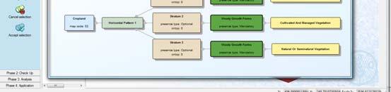
11 Standards and Tools Mapping Device Change Analysis Tools (MADCAT) Application designed by FAO Uses object base classification Current version Release June 2013 Wizard driven installation Implemented using.net Framework Coding with LCCS2 and LCCS3 Requires Windows XP / Vista / 7 /8 (32 and 64 bit) Free to use for FAO programmes One time activation needed: Institution, User Name, Address, PC CODE send request by


12 Africa Land Cover products FAO s Land Cover Mapping in Africa Country scale (30m or better resolution) on going ECONET Ethiopia 2012 Fouta Djallon Highlands Malawi 2011 Sudan 2010 South Sudan Tunisia Kenya Update 2007 Somalia 2006 Kenya LCC 2005 Senegal 2004 Libya AFRICOVER
13 Africa Land Cover products GLCN/AFRICOVER: East Africa Module Project facts: Mapped area: 8.5 million Km2 Countries covered: 10 Landsat Scenes used: more than 400 Period of activity: i Result: Multipurpose Africover Database for the Environmental Resources produced at a 1:200,000 scale (1:100,000 for small countries and specific areas) Development of a regional database and regional aggregation Burundi DR Congo Egypt Eritrea Burundi, DR Congo, Egypt, Eritrea, Kenya, Rwanda, Somalia, Sudan, Tanzania and Uganda.


 1990-2005 ASTER")


14 Africa Land Cover products Fouta Djallon Highlands land cover change Fouta Djallon AOI: ca. 400, Km 2 5 Countries within the AOI: Guinea, Guinea-Bissau, Mali, Senegal, Sierra Leone LANDSAT coverage (30m res) ASTER coverage (17 m res) RapidEye coverage (5 m res) ~2005 Fouta Djallon Highlands land cover changes AG NVH NVS NVT URB WAT


 and")

")

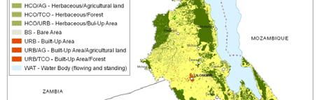
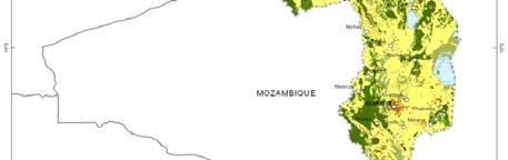
15 Africa Land Cover products Malawi Land Cover change database (1990 s-2010 s) From other to cropland (square blue) and vice versa (circle orange)


 Posters Skin Implemented in Sudan")
16 Africa Land Cover products Sudan Land Cover Primary datasets: Landsat 30m (~2000, ~ ) Spot4 imagery , 2010, 2.5-5m, 5m, m res IRS 2007, 15-22m res Aster ,15 m res. Ancillary: Googe Earth high resolution imagery Africover dataset (dated ) ATLAS of Sudan Digital ATLAS (DVD) Posters Skin Implemented in Sudan Capacity to undertake land cover assessments


17 Africa Land Cover products Land Cover Map of South Sudan Primary: Landsat ETM imagery (GLS), 30m res., false color circa Spot4 imagery , m res., true color. Ancillary Google Earth high resolution imagery Africover datasets


18 Africa Land Cover products Senegal Land Cover Change: land cover classes Landsat 1990 s and 2005 s Completed in Senegal with involvement of national exerts OURCES AL RESO NATURA
19 Africa Land Cover products Libya Land Cover database Landsat ETM+ imagery 2001 s and 2002 s 88 landsat scenes in total OURCES AL RESO NATURA
20 Africa Land Cover products ECO NET Africa Earth Cover Network Africa Sample tiles at 10 by 10 Km at half degree Very high resolution Herbaceous Cover % Cultivated imagery (targeted 5m or Rainfed better) Detailed land cover mapping using LCML enriched with vegetation index(es) from remote sensing About 9,000 sampling sites Coordinated d and supervised by FAO GLCN with engagement of national 0.30 experts BASIC OBJECTS PROPRERTIES CHARACTERISTICS Field size 1 ha Tree Cover 1-3 % Natural Eight 5-8 m. Disposition: irregular Leaf type: Broadleaf Leaf type % 100 Scrub Cover 2 4 % Natural Eight 1 3 m. Disposition: irregular Leaf type: Broadleaf Leaf type % 100 NDVI Average Average Total St. Deviation Dekad NDVI Standard Deviatio on 0.00


21 Africa Land Cover products ECONET Outcomes Create a database with extremely detailed information, global or regional, comparable and continually updated in support of a wide range of activities. Serve as multi-statistical source of information at any level of detail or complexity. Using specific software on the Web, any end users worldwide will be able to define a geographical area and the categories for which area statistics will be generated. Provide the most consistent, detailed and dynamic test site for calibration and/or accuracy assessment of any future wallto-wall global, regional or national Land Cover mapping programmes


 should be adopted at the methodology for linking to external sources of land")
22 GLC-SHARE database GLC-SHARE approach FAO System of Environmental Economic Accounts (SEEA) London Group process Global Consultations, interviews, comments, questions, recommendation A significant step in improving the information accuracy of global land cover database It integrates the best land cover data available (at subnational, national, regional and global level) into one single harmonized database It uses international standards: ISO TC :2013 LMCL systems. Recommendation 19b.1: That the Land Cover Classification System (LCCS 3) developed by FAO should be adopted d as the land cover classification system in the revised SEEA and that the LCML (ISO ) should be adopted at the methodology for linking to external sources of land cover data described in other land cover
23 GLC-SHARE database GLC-SHARE design principles Use existing available land cover databases at national, regional and global level; Use the best available spatio-temporal land cover databases; Use the land cover legend prepared by SEEA and FAO based on the Land Cover Meta-Language; Make use of the harmonization of the land cover elements addressing semantic requirements; Use data fusion technology; Progressively update the database getting input from the community of users and include additional datasets as they become available.


24 GLC-SHARE database GLC-SHARE: fact-sheet Uses the FAO SEEA LCML(*) legend 30 arc-second pixel resolution 11+1 layers indicating the % share of each class Dominant land cover layer and quality score Overall class accuracy ~80% Designed as a platform to facilitate crowd-sourcing Compatible with FAOSTAT classification Designed to be used for GAEZ 2010 update Methodology and datasets will be published in 2013


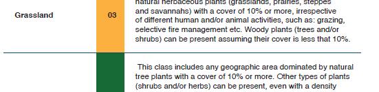
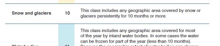
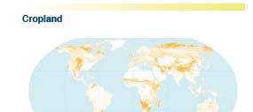
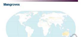
25 GLC-SHARE SEEA Legend GLC-SHARE database NATURAL RESOURCES DEPARTMENT (NR)
26 GLC-SHARE SEEA LCML Legend GLC-SHARE database NATURAL RESOURCES DEPARTMENT (NR)
27 GLC-SHARE database Coverage of land cover databases NATURAL RESOURCES DEPARTMENT (NR)


 Outputs t")


28 GLC-SHARE database Processing Chain Multi-source and multi-resolution data fusion through use of the land cover class elements and the LCML Class confidence levels l used in the processing chain to use the optimal spatio-temporal information at pixel level Per product and per class rating assigned by technical experts (experts opinion) Outputs t include 11 rasters at 30 arc-second, 1 dominant land cover dataset, 1 quality indicator dataset including source date, resolution, sensor and confidence level per pixel, metadata, and technical paper


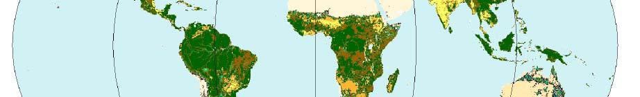
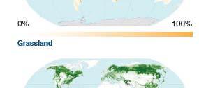

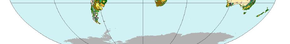
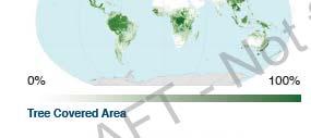
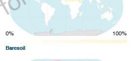
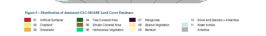
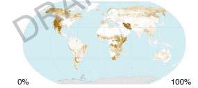
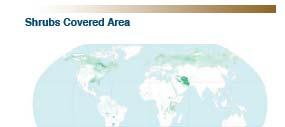
29 GLC-SHARE database GLC-Share Database NATURAL RESOURCES DEPARTMENT (NR)
30 GLC-SHARE database Quality Assessment Used ~1,000 points (ArcGIS and Google Earth validation) Overall dominant class accuracy ~80% Distribution of the validation points
31 GLC-SHARE database NATURAL RESOURCES DEPARTMENT (NR)
32 GLC-SHARE database GLC-SHARE Summary GCL-SHARE is the first global database created using the ISO standard for land cover classification ISO TC LMCL (Land Cover Meta Language) and is designed to be improved over time GLC-SHARE will be used for GAEZ 2010 update GLC-SHARE will be used to update Land Use Systems 2010 (FAO) Planned to be made publicly available for comments and feedback by end of 2013 Fully documented, d including metadata, t LCML/LCCS3 legend Update of the beta release with new available datasets including the global coverage of Landsat 30 meter and new national land cover datasets Maintained by FAO and community of practice partners y y p p such as GEO, CGIAR, JRC, IIASA
33 Thank you Contacts: FAO Links:
UNITED NATIONS GEOGRAPHIC INFORMATION WORKING GROUP
 UNGIWG UNITED NATIONS GEOGRAPHIC INFORMATION WORKING GROUP New York, May 2014 UNSPACE & UNGIWG 14 INTRO. The United Nations Geographic Information Working Group (UNGIWG) is a voluntary network of UN professionals
Programme. MC : Byron Anangwe. Morning Session
 Programme MC : Byron Anangwe Morning Session DAY 2 Summary MC : Byron Anangwe The USGS global land cover mapping initiative Land use and land cover mapping at the Joint Research Centre Alan Belward FAO
Land Cover Project ESA Climate Change Initiative. Processing chain for land cover maps dedicated to climate modellers.
 Land Cover Project ESA Climate Change Initiative Processing chain for land cover maps dedicated to climate modellers land_cover_cci S. Bontemps 1, P. Defourny 1, V. Kalogirou 2, F.M. Seifert 2 and O. Arino
Land Use / Land Cover Mapping in
 Land Use / Land Cover Mapping in Eastern and Southern African Regions RCMRD Experience by 6/24/2013, Nairobi Kenya Dr. Tesfaye Korme Director of RS, GIS and Mapping, RCMRD I. About RCMRD, Its Vision and
FAO GAEZ Data Portal
 FAO GAEZ Data Portal www.fao.org/nr/gaez Renato Cumani Environment Officer Land and Water Division Natural Resources Management and Environment Department Food and Agriculture Organization of the UN October
African requirements for SDI standardization Antony Cooper Operating Unit Fellow Built Environment CSIR PO Box 395, Pretoria, 0001, South Africa
 ISO/TC 211 workshop on spatial data infrastructures (SDIs) African requirements for SDI standardization Antony Cooper Operating Unit Fellow Built Environment CSIR PO Box 395, Pretoria, 0001, South Africa
IGAD Biodiversity Management Program Regional Biodiversity Data Base and RRIS Nairobi November. FAO DDNS Division FAO - Rome
 IGAD Biodiversity Management Program Regional Biodiversity Data Base and RRIS Nairobi 28-29 November FAO- DDNS and Global Land Cover Network(GLCN) overview on, standards, tools and products Antonio Di
Capabilities and Limitations of Land Cover and Satellite Data for Biomass Estimation in African Ecosystems Valerio Avitabile
 Capabilities and Limitations of Land Cover and Satellite Data for Biomass Estimation in African Ecosystems Valerio Avitabile Kaniyo Pabidi - Budongo Forest Reserve November 13th, 2008 Outline of the presentation
Training on national land cover classification systems. Toward the integration of forest and other land use mapping activities.
 Training on national land cover classification systems Toward the integration of forest and other land use mapping activities. Guiana Shield 9 to 13 March 2015, Paramaribo, Suriname Background Sustainable
FAO s LAND COVER AND LAND USE ACTIVITIES - UPDATE OCTOBER
 FAO s LAND COVER AND LAND USE ACTIVITIES - UPDATE OCTOBER 1997 - Background There is an increasing need to be able to precisely describe and classify land cover and land uses in order to define sustainable
Building a validation database for land cover products from high spatial resolution images
 Building a validation database for land cover products from high spatial resolution images The Land Cover project of the ESA Climate Change Initiative Bontemps Sophie 1, Achard Frédéric 2, Lamarche Céline
LAND USE, LAND COVER AND SOIL SCIENCES Vol. I - AFRICOVER Land Cover Classification and Mapping Project - Antonio Di Gregorio, John Latham
 AFRICOVER LAND COVER CLASSIFICATION AND MAPPING PROJECT Antonio Di Gregorio Food and Agriculture Organisation of the United Nations (FAO), Africover Project, Kenya John Latham Food and Agriculture Organisation
THE ROLE OF SEAMIC IN SUSTAINABLE MINERAL RESOURCES DEVELOPMENT IN AFRICA
 THE ROLE OF SEAMIC IN SUSTAINABLE MINERAL RESOURCES DEVELOPMENT IN AFRICA Ketema Tadesse Director General-SEAMIC Dar es Salaam, Tanzania August 11, 2009 SEAMIC BACKGROUND SEAMIC was established in 1977
AAG Partnerships for. Sustainable Development in Africa: Geospatial Science & Technology for. Partnerships and Applications
 AAG Partnerships for Sustainable Development in Africa Geospatial Science & Technology for Sustainable Development in Africa: Partnerships and Applications Harvard University John F. Kennedy School of
COMBINING ENUMERATION AREA MAPS AND SATELITE IMAGES (LAND COVER) FOR THE DEVELOPMENT OF AREA FRAME (MULTIPLE FRAMES) IN AN AFRICAN COUNTRY:
 FOR THE DEVELOPMENT OF AREA FRAME (MULTIPLE FRAMES) IN AN AFRICAN COUNTRY:") COMBINING ENUMERATION AREA MAPS AND SATELITE IMAGES (LAND COVER) FOR THE DEVELOPMENT OF AREA FRAME (MULTIPLE FRAMES) IN AN AFRICAN COUNTRY: PRELIMINARY LESSONS FROM THE EXPERIENCE OF ETHIOPIA BY ABERASH
COMBINING ENUMERATION AREA MAPS AND SATELITE IMAGES (LAND COVER) FOR THE DEVELOPMENT OF AREA FRAME (MULTIPLE FRAMES) IN AN AFRICAN COUNTRY: PRELIMINARY LESSONS FROM THE EXPERIENCE OF ETHIOPIA BY ABERASH
Making a Mental Map of the Region
 Africa Preview Making a Mental Map of the Region Draw an outline map of Africa on the next page or on a separate sheet of paper. Add a compass rose to your map, showing where north, south, east, and west
Module 2.1 Monitoring activity data for forests using remote sensing
 Module 2.1 Monitoring activity data for forests using remote sensing Module developers: Frédéric Achard, European Commission (EC) Joint Research Centre (JRC) Jukka Miettinen, EC JRC Brice Mora, Wageningen
Fundamental Geospatial Datasets in Africa. Andre Nonguierma New York, 03 August 2015
 Fundamental Geospatial Datasets in Africa United Nations Economic Commission for Africa Geoinformation & Spatial Statistics Andre Nonguierma New York, 03 August 2015 Core Data : Lack of consistency Infrastructure
The Global Statistical Geospatial Framework and the Global Fundamental Geospatial Themes
 The Global Statistical Geospatial Framework and the Global Fundamental Geospatial Themes Sub-regional workshop on integration of administrative data, big data and geospatial information for the compilation
SHaSA. Strategy for the Harmonization of Statistics in Africa
 BANQUE AFRICAINE DE DEVELOPPEMENT AFRICAN DEVELOPMENT FUND Strategy for the Harmonization of Statistics in Africa Strategy for the Harmonization of Statistics in Africa 2017-2026 SHaSA Multi-Year Action
Economic and Social Council
 United Nations Economic and Social Council Distr.: General 2 July 2012 E/C.20/2012/10/Add.1 Original: English Committee of Experts on Global Geospatial Information Management Second session New York, 13-15
Land Surface Processes and Land Use Change. Lex Comber
 Land Surface Processes and Land Use Change Lex Comber ajc36@le.ac.uk Land Surface Processes and Land Use Change Geographic objects in GIS databases Detecting land use change using multitemporal imaging
The Global Land Cover Facility
 The Global Land Cover Facility REASoN Activities John Townshend, Principal Investigator Joseph JaJa, Co-Principal Investigator Paul Davis, Science Manager University of Maryland January 2004 The GLCF The
Mapping African buffalo distributions, in relation to livestock disease risk
 Mapping African buffalo distributions, in relation to livestock disease risk Tim Robinson and Jennifer Siembieda Buffalo Mapping Meeting 7-8 June, Rome FAO, Canada Room Overview Modelling densities of
An Automated Object-Oriented Satellite Image Classification Method Integrating the FAO Land Cover Classification System (LCCS).
.") An Automated Object-Oriented Satellite Image Classification Method Integrating the FAO Land Cover Classification System (LCCS). Ruvimbo Gamanya Sibanda Prof. Dr. Philippe De Maeyer Prof. Dr. Morgan De
An Automated Object-Oriented Satellite Image Classification Method Integrating the FAO Land Cover Classification System (LCCS). Ruvimbo Gamanya Sibanda Prof. Dr. Philippe De Maeyer Prof. Dr. Morgan De
Jordan Land Cover Mapping Data Preparation. Emanuela De Leo, John Latham, Lorenzo De Simone (DDNS)
") Jordan Land Cover Mapping Data Preparation Emanuela De Leo, John Latham, Lorenzo De Simone (DDNS) FOOD AND AGRICULTURE ORGANIZATION OF THE UNITED NATIONS Rome 2016 2 FAO/Jordan Land Cover and Land Cover
Jordan Land Cover Mapping Data Preparation Emanuela De Leo, John Latham, Lorenzo De Simone (DDNS) FOOD AND AGRICULTURE ORGANIZATION OF THE UNITED NATIONS Rome 2016 2 FAO/Jordan Land Cover and Land Cover
Access to global land cover reference datasets and their suitability for land cover mapping activities
 Access to global land cover reference datasets and their suitability for land cover mapping activities Brice Mora, N.E.Tsendbazar, M.Herold LPVE meeting, Frascati, January 29, 2014 Outlook 1. Background
African Coastal Atlas developments. 10 July 2008 EEA Copenhagen, Denmark
 African Coastal Atlas developments 10 July 2008 EEA Copenhagen, Denmark Africa Overview Africa has approximately 40 000 km of coast across 32 mainland countries and four island states. Africa's coastal
ESA-GLOBCOVER - A Global Land Cover Service at 300 m from ENVISAT MERIS Time Series
 October 15, 2008 (Jena Germany) ESA-GLOBCOVER - A Global Land Cover Service at 300 m from ENVISAT MERIS Time Series Defourny P.1, Bontemps S., Vancutsem C.1, Pekel J.F.1,, Vanbogaert E.1, Bicheron P.2,
Land Cover and Land use in Environment Statistics
 UNITED NATIONS STATISTICS DIVISION (UNSD) Workshop on Environment Statistics in support of the implementation of the Framework for the Development of Environment Statistics (FDES 2013) Balaclava, Mauritius
Module 3 Indicator Land Consumption Rate to Population Growth Rate
 Regional Training Workshop on Human Settlement Indicators Module 3 Indicator 11.3.1 Land Consumption Rate to Population Growth Rate Dennis Mwaniki Global Urban Observatory, Research and Capacity Development
NSDI as a tool for Secure land tenure
 NSDI as a tool for Secure land tenure General Overview To look at the progress in SDI development and its application in policy formulation and impact on land tenure. INTEGRATION OF INFORMATION POLICIES
2018/1 The integration of statistical and geospatial information. The Regional Committee of UN-GGIM: Americas:
 The following are the conclusions and recommendations of the Regional Committee of the United Nations on Global Geospatial Information Management for the Americas, during its Fifth Session, Thursday 8
Development of a Regional Land Cover Monitoring System In the Lower Mekong Region a Joint Effort Between SERVIR-Mekong and Partners -
 Mekong Development of a Regional Land Cover Monitoring System In the Lower Mekong Region a Joint Effort Between SERVIR-Mekong and Partners - Aekkapol Aekakkararungroj SERVIR-Mekong Asian Disaster Preparedness
Africa RiskView MONTHLY BULLETIN JANUARY Highlights: Rainfall
 The Africa RiskView Bulletin is a monthly publication by the African Risk Capacity (ARC). ARC is a Specialised Agency of the African Union designed to improve the capacity of AU Member States to manage
MANUAL ON THE BSES: LAND USE/LAND COVER
 6. Environment Protection, Management and Engagement 2. Environmental Resources and their Use 5. Human Habitat and Environmental Health 1. Environmental Conditions and Quality 4. Disasters and Extreme
a division of Teacher Created Materials
 Sample Pages from a division of Teacher Created Materials Thanks for checking us out. Please call us at 877-777-3450 with questions or feedback, or to order this product. You can also order this product
Roadmap to interoperability of geoinformation
 Roadmap to interoperability of geoinformation and services in Europe Paul Smits, Alessandro Annoni European Commission Joint Research Centre Institute for Environment and Sustainability paul.smits@jrc.it
REMOTELY SENSED INFORMATION FOR CROP MONITORING AND FOOD SECURITY
 LEARNING OBJECTIVES Lesson 4 Methods and Analysis 2: Rainfall and NDVI Seasonal Graphs At the end of the lesson, you will be able to: understand seasonal graphs for rainfall and NDVI; describe the concept
North-South Gap Mapping Assignment Country Classification / Statistical Analysis
 North-South Gap Mapping Assignment Country Classification / Statistical Analysis Due Date: (Total Value: 55 points) Name: Date: Learning Outcomes: By successfully completing this assignment, you will be
Geography for the 2020 Round of Census
 Boundaries Key Census Data EA Id Population Male Female EA Id Area EA Id Num HH Avg HH size Geography for the 2020 Round of Census Linda Peters, Esri lpeters@esri.com Integration of Statistical and Geospatial
choice have on a particular application? For example, Fritz et al. (2010a) have shown that comparing global land cover (GLC-2000) with the equivalent
 have shown that comparing global land cover (GLC-2000) with the equivalent") Improving Global Land Cover through Crowd-sourcing and Map Integration L. See 1, S. Fritz 1, I. McCallum 1, C. Schill 2, C. Perger 3 and M. Obersteiner 1 1 International Institute for Applied Systems Analysis
Improving Global Land Cover through Crowd-sourcing and Map Integration L. See 1, S. Fritz 1, I. McCallum 1, C. Schill 2, C. Perger 3 and M. Obersteiner 1 1 International Institute for Applied Systems Analysis
GMES and AFRICA Support Programme 1st technical committee meeting
 GMES and AFRICA Support Programme 1st technical committee meeting Developing an Earth Observation Operational Application for Coastal Ecosystems Mapping, Monitoring and Assessment of the Northern African
Challenges and Successes in Sharing Geospatial Data in Africa
 Challenges and Successes in Sharing Geospatial Data in Africa 2018 GeoNode Summit Torino, Italy March 26-28, 2018 Bernard Justus Muhwezi Manager, Geo-Information Services Uganda Bureau of Statistics, Kampala,
Establishment of a Common and Modern African Geodetic Reference System (Afref)
") Establishment of a Common and Modern African Geodetic Reference System (Afref) SUMMARY There are almost as many geodetic reference systems in African as there are countries. Sharing of data as is envisaged
Establishment of a Common and Modern African Geodetic Reference System (Afref) SUMMARY There are almost as many geodetic reference systems in African as there are countries. Sharing of data as is envisaged
Understanding riverine wetland-catchment processes using remote sensing data and modelling
 Understanding riverine wetland-catchment processes using remote sensing data and modelling Yunqing Xuan (UNESCO-IHE, NL) Didier Haguma (KIST, Rwanda) William Niyonzima (UNESCO-IHE, NL) Ann van Griensven
Dynamic Land Cover Dataset Product Description
 Dynamic Land Cover Dataset Product Description V1.0 27 May 2014 D2014-40362 Unclassified Table of Contents Document History... 3 A Summary Description... 4 Sheet A.1 Definition and Usage... 4 Sheet A.2
GENERAL RECOMMENDATIONS. Session 7. Breakout discussion. discuss on regional and interregional. proposals 1. COLLABORATION BETWEEN PROGRAMMES
 Session 7 24 July 2016, 9.00-11.00 Breakout discussion on regional and interregional joint project proposals Mr Shahbaz Khan summarized the two days of presentations and exchanges and requested the participants
ZFL, Center of Remote Sensing of Land Surfaces, University of Bonn, Germany. Geographical Institute, University of Bonn, Germany
 Communication of Research Results The IMPETUS Atlas H.-P. Thamm 1, M. Judex 1, O.Schultz 2, S.Krüger 1 & M. Christoph 3 1 ZFL, Center of Remote Sensing of Land Surfaces, University of Bonn, Germany 2 Geographical
KNOWLEDGE-BASED CLASSIFICATION OF LAND COVER FOR THE QUALITY ASSESSEMENT OF GIS DATABASE. Israel -
 KNOWLEDGE-BASED CLASSIFICATION OF LAND COVER FOR THE QUALITY ASSESSEMENT OF GIS DATABASE Ammatzia Peled a,*, Michael Gilichinsky b a University of Haifa, Department of Geography and Environmental Studies,
Gridded Population of the World Version 4 (GPWv4)
") Gridded Population of the World Version 4 (GPWv4) Greg Yetman Chris Small Erin Doxsey-Whitfield Kytt MacManus May 28, 2015 Global Urbanization Workshop http://sedac.ciesin.columbia.edu 1 Focus on applying
Gridded Population of the World Version 4 (GPWv4) Greg Yetman Chris Small Erin Doxsey-Whitfield Kytt MacManus May 28, 2015 Global Urbanization Workshop http://sedac.ciesin.columbia.edu 1 Focus on applying
COUHCIL. tlnited NATIONS. and SOCIAL E/CN.U/CAP.3/12 LI7O-693. Addis Ababa, 20 to 29 May April Original: ENGLISH. Distr.
 tlnited NATIONS fcohomic and SOCIAL COUHCIL Distr. LIMITED E/CN.U/CAP.3/12 2 April 1970 Original: ENGLISH ECONOMIC COMMISSION FOR AFRICA Conference of African Planners Third session Addis Ababa, 20 to
NATIONAL MAPPING EFFORTS: THE PHILIPPINES
 NATIONAL MAPPING EFFORTS: THE PHILIPPINES Dr. RIJALDIA N. SANTOS DENR National Mapping and Resource Information Authority (NAMRIA) May 30, 2018 Land Cover/Land Use Changes (LC/LUC) and Its Impacts on Environment
7.1 INTRODUCTION 7.2 OBJECTIVE
 7 LAND USE AND LAND COVER 7.1 INTRODUCTION The knowledge of land use and land cover is important for many planning and management activities as it is considered as an essential element for modeling and
CODATA Catalog of Roads Data Sets, v1 October 2009
 CODATA Catalog of Roads Data Sets, v1 October 2009 This is a summary version of the data available in the full catalog, available for download in MS Access (2000) format. The catalog contains 367 entries.
PRECIS: Facilitating capacity building and climate vulnerability studies and applications in Africa
 PRECIS: Facilitating capacity building and climate vulnerability studies and applications in Africa Richard Jones Presentation to Met Africa group, Reading University 15.10.2007 Crown copyright Page 1
SIGMA thematic map validation
 LPVE 2018 1 LPVE 2018 2 SIGMA GIS validation tools Thematic map validation plugin with 3 tools: Estimate sample size tool Estimate sample size using map class accuracies tool Build confusion matrix - tool
The contribution of VEGETATION
 The contribution of VEGETATION /SPOT4 products to remote sensing applications for food security, early warning and environmental monitoring in the IGAD sub region G. Pierre, C. Crépeau, P. Bicheron, T.
CountrySTAT REGIONAL BASIC ADMINISTRATOR TRAINING for GCC MEMBER STATES. CountrySTAT STATISTICS COMPONENT
 CountrySTAT REGIONAL BASIC ADMINISTRATOR TRAINING for GCC MEMBER STATES Abu Dhabi, United Arab Emirates (UAE), 26 30 January 2014 CountrySTAT STATISTICS COMPONENT (Concepts, Definitions, Classification,
Assisting Countries in the Collection and Analysis of National Statistics
 Assisting Countries in the Collection and Analysis of National Statistics Peter O. Way, Ph.D., Chief International Programs Center U.S. Census Bureau Censuses in the 21 st Century: Improving Data Utilization
Mapping forests in monsoon Asia with ALOS PALSAR 50-m mosaic images and MODIS
 1 Supplementary Information 2 3 Mapping forests in monsoon Asia with ALOS PALSAR 50-m mosaic images and MODIS imagery in 2010 4 5 6 7 8 9 10 11 Yuanwei Qin, Xiangming Xiao, Jinwei Dong, Geli Zhang, Partha
DEVELOPMENT OF GPS PHOTOS DATABASE FOR LAND USE AND LAND COVER APPLICATIONS
 DEVELOPMENT OF GPS PHOTOS DATABASE FOR LAND USE AND LAND COVER APPLICATIONS An Ngoc VAN and Wataru TAKEUCHI Institute of Industrial Science University of Tokyo 4-6-1 Komaba, Meguro-ku, Tokyo 153-8505 Japan
Economic and Social Council
 United Nation E/C.20/2012/4/Add.1 Economic and Social Council Distr.: General 2 July 2012 Original: English Committee of Experts on Global Geospatial Information Management Second session New York, 13-15
Summary Description Municipality of Anchorage. Anchorage Coastal Resource Atlas Project
 Summary Description Municipality of Anchorage Anchorage Coastal Resource Atlas Project By: Thede Tobish, MOA Planner; and Charlie Barnwell, MOA GIS Manager Introduction Local governments often struggle
GED4ALL Global Exposure Database for Multi-Hazard Risk Analysis
 GED4ALL Global Exposure Database for Multi-Hazard Risk Analysis D5 - FINAL REPORT Silva V, Henshaw P, Huyck C, O Hara M submitted by: The Global Earthquake Model Foundation (GEM) Via Ferrata 1, 27100 Italy
Arctic Spatial Data Infrastructure Enabling Access to Arctic Location-Based Information
 Arctic Spatial Data Infrastructure Enabling Access to Arctic Location-Based Information Arctic SDI Side Event Co-Chairs: Arvo Kokkonen Arctic SDI Board Chair & Director General, National Land Survey of
A contribution to GEOSS from the SDI for Georesources in Africa
 A contribution to GEOSS from the SDI for Georesources in Africa A. TELLEZ-ARENAS BRGM, France in behalf of: Dr. Marc URVOIS Project Coordinator BRGM, France Mineral Resources Division INSPIRE Conference
PTV Africa City Map 2017 (Standardmap)
") PTV Africa City Map 2017 (Standardmap) Map version name (Core) Map version name (Logistic) Release date (Logistics) Map version name (Logistics) (new) PTV_Africa_City_Map_2017 Data provider(s) Technology
PTV Africa City Map 2017 (Standardmap) Map version name (Core) Map version name (Logistic) Release date (Logistics) Map version name (Logistics) (new) PTV_Africa_City_Map_2017 Data provider(s) Technology
Developing Spatial Data Infrastructure (SDI) in Africa: A cooperative Geospatial information Management process
 in Africa: A cooperative Geospatial information Management process") IAMOSA Geneva 16-18 March 2011 Developing Spatial Data Infrastructure (SDI) in Africa: A cooperative Geospatial information Management process United Nations Economic Commission for Africa ICT and Sciences
IAMOSA Geneva 16-18 March 2011 Developing Spatial Data Infrastructure (SDI) in Africa: A cooperative Geospatial information Management process United Nations Economic Commission for Africa ICT and Sciences
Modeling the EU s Everything But Arms Initiative for the Least Developed Countries
 Modeling the EU s Everything But Arms Initiative for the Least Developed Countries Michael Trueblood and Agapi Somwaru U.S. Dept. of Agriculture Economic Research Service Markets and Trade Analysis Division
Weather Climate Science to Service Partnership South Africa
 PROJECTS UNDERWAY Title of the Weather Climate Science to Service Partnership South Africa Together, building on an existing strong partnership, South African Weather Service and the Met Office will build
Global City Definition
 Regional Training Workshop on Human Settlement Indicators Global City Definition Dennis Mwaniki Global Urban Observatory, Research and Capacity Development Branch, UN-Habitat Bangkok, Thailand Outline
Identifying Audit, Evidence Methodology and Audit Design Matrix (ADM)
") 11 Identifying Audit, Evidence Methodology and Audit Design Matrix (ADM) 27/10/2012 Exercise XXX 2 LEARNING OBJECTIVES At the end of this session participants will be able to: 1. Identify types and sources
11 Identifying Audit, Evidence Methodology and Audit Design Matrix (ADM) 27/10/2012 Exercise XXX 2 LEARNING OBJECTIVES At the end of this session participants will be able to: 1. Identify types and sources
Development of Global Map for GEOSS SBAs US-09-03a
 Development of Global Map for GEOSS SBAs US-09-03a UIC User Engagement Session 2 November, 2010 Yoshikazu FUKUSHIMA Secretariat General of International Steering Committee for Global Mapping Geospatial
Outcomes of the Workshop on the Geologic and Geothermal Development of the Western Branch of the Greater East African Rift System
 Outcomes of the Workshop on the Geologic and Geothermal Development of the Western Branch of the Greater East African Rift System East Africa Donor Coordination Meeting 14 June 2016 AUC Headquarter Addis
REPORT ON ACTIVITIES UNDERTAKEN SINCE THE 25TH SESSION OF THE INTERNATIONAL COORDINATING COUNCIL OF THE MAN & THE BIOSPHERE PROGRAMME
 AFRICAN NETWORK OF BIOSPHERE RESERVES (AFRIMAB) REPORT ON ACTIVITIES UNDERTAKEN SINCE THE 25TH SESSION OF THE INTERNATIONAL COORDINATING COUNCIL OF THE MAN & THE BIOSPHERE PROGRAMME 26 TH MAB ICC SESSION
Historical background
 Space Technology for Disaster Management in Sri Lanka: Country profile, national perspectives & vision. Professor Ranjith Premalal De Silva Vice Chancellor Uva Wellassa University of Sri Lanka October
Brian D. George. GIMS Specialist Ohio Coastal Atlas Project Coordinator and Cartographer. Impacts and Outcomes of Mature Coastal Web Atlases
 Ohio Coastal Atlas Project Brian D. George GIMS Specialist Ohio Coastal Atlas Project Coordinator and Cartographer Ohio Department of Natural Resources Office of Coastal Management Sandusky, OH Impacts
Patrick Leinenkugel. German Aerospace Center (DLR) Vortrag > Autor > Dokumentname > Datum
 Vortrag > Autor > Dokumentname > Datum") Characterisation of land surface phenology and land cover for the Mekong Basin on the basis of multitemporal and multispectral satellite data from the MODIS Sensor Patrick Leinenkugel German Aerospace
Characterisation of land surface phenology and land cover for the Mekong Basin on the basis of multitemporal and multispectral satellite data from the MODIS Sensor Patrick Leinenkugel German Aerospace
Journey to create opportunities in Sierra Leone using Esri s ArcGIS Platform Presented by:
 Journey to create opportunities in Sierra Leone using Esri s ArcGIS Platform Presented by: John Clark, Getech Group Plc, on behalf of The Petroleum Directorate Sierra Leone Summary The mission of the Petroleum
Using satellite images to calculate land use and land cover statistics
 Using satellite images to calculate land use and land cover statistics National Administrative Department of Statistics DANE Colombia April 2016 @DANE_Colombia /DANEColombia /DANEColombia Background (1)
Regional Centre for Mapping of Resources for Development (RCMRD), Nairobi, Kenya
, Nairobi, Kenya") Regional Centre for Mapping of Resources for Development (RCMRD), Nairobi, Kenya Introduction to GIS (2 weeks: 10 days) Intakes: 8 th January, 6 th February, 5th March, 3 rd. April 9 th, May 7 th, June
Regional Centre for Mapping of Resources for Development (RCMRD), Nairobi, Kenya Introduction to GIS (2 weeks: 10 days) Intakes: 8 th January, 6 th February, 5th March, 3 rd. April 9 th, May 7 th, June
Global land cover mapping GLCNMO and data sharing system CEReS Gaia
 Global land cover mapping GLCNMO and data sharing system CEReS Gaia Ryutaro Tateishi Center for Environmental Remote Sensing(CEReS) Chiba University E-mail: tateishi@faculty.chiba-u.jp Production of 500
7 TO 17 AUGUST 2017 NEW YORK. TASK TEAM FOR AFRICA by. Brahim Atoui : TTA, Convenor
 7 TO 17 AUGUST 2017 NEW YORK TASK TEAM FOR AFRICA by Brahim Atoui : TTA, Convenor Geographical Names standardization in Africa: Challenges and constraints A decade of actions BRIEF HISTORY African Countries
Cambridge International Examinations Cambridge Ordinary Level
 Cambridge International Examinations Cambridge Ordinary Level *2207173583* GEOGRAPHY 2217/13 Paper 1 May/June 2017 Candidates answer on the Question Paper. Additional Materials: Calculator Ruler 1 hour
Internet Business Council for Africa (IBCA) Comment on GAC Proposal for Protection of Geographic Names in New gtlds
 Comment on GAC Proposal for Protection of Geographic Names in New gtlds") Internet Business Council for Africa (IBCA) Comment on GAC Proposal for Protection of Geographic Names in New gtlds 12/1/2014 The Internet Business Council for Africa (IBCA), an initiative introduced in
Internet Business Council for Africa (IBCA) Comment on GAC Proposal for Protection of Geographic Names in New gtlds 12/1/2014 The Internet Business Council for Africa (IBCA), an initiative introduced in
KENYA NATIONAL BUREAU OF STATISTICS Workshop on
 KENYA NATIONAL BUREAU OF STATISTICS Workshop on Capacity Building in Environment Statistics: the Framework for the Development of Environment Statistics (FDES 2013) Coordination with Sector Ministries
Reducing Consumer Uncertainty
 Spatial Analytics Reducing Consumer Uncertainty Eliciting User and Producer Views on Geospatial Data Quality Introduction Cooperative Research Centre for Spatial Information (CRCSI) in Australia Communicate
The Geospatial Census: plans and progress for the 2010 round of population censuses
 The Geospatial Census: plans and progress for the 2010 round of population censuses David Rain, Assistant Professor of Geography & International Affairs, and Consultant to the United Nations/UNSD drain@gwu.edu
Historical Assessment of Spatial Growth of Builtups in Metropolitan areas of Delhi and Mumbai in India and Dhaka in Bangladesh
 Historical Assessment of Spatial Growth of Builtups in Metropolitan areas of Delhi and Mumbai in India and Dhaka in Bangladesh Tomas Soukup, GISAT BBL session, World Bank HQ, Washington DC Date : 10 January
The Combination of Geospatial Data with Statistical Data for SDG Indicators
 Session x: Sustainable Development Goals, SDG indicators The Combination of Geospatial Data with Statistical Data for SDG Indicators Pier-Giorgio Zaccheddu Fabio Volpe 5-8 December2018, Nairobi IAEG SDG
Using Earth Observation Data for Monitoring River Basins
 Using Earth Observation Data for Monitoring River Basins The NBI Experience By Milly Mbuliro GIS/ Remote Sensing Specialist Nile Basin Initiative Secretariat NBDF, 23 rd -25 th October, Kigali Convention
DP Project Development Pvt. Ltd.
 Dear Sir/Madam, Greetings!!! Thanks for contacting DP Project Development for your training requirement. DP Project Development is leading professional training provider in GIS technologies and GIS application
PTV Africa City Map (Standardmap)
") PTV Africa City Map 2018.2 (Standardmap) Map version name (Core) Map version name (Logistic) Release date (Logistics) Map version name (Logistics) (new) PTV_Africa_City_Map_2018.2 Data provider(s) Technology
PTV Africa City Map 2018.2 (Standardmap) Map version name (Core) Map version name (Logistic) Release date (Logistics) Map version name (Logistics) (new) PTV_Africa_City_Map_2018.2 Data provider(s) Technology
Spatially Enabled Society
 International Seminar on Land Administration Trends and Issues in Asia and the Pacific Region Spatially Enabled Society Abbas Rajabifard Vice Chair PCGIAP-WG3 Vice-President (President Elect), GSDI Association
An Internet-based Agricultural Land Use Trends Visualization System (AgLuT)
") An Internet-based Agricultural Land Use Trends Visualization System (AgLuT) Prepared for Missouri Department of Natural Resources Missouri Department of Conservation 07-01-2000-12-31-2001 Submitted by
An Internet-based Agricultural Land Use Trends Visualization System (AgLuT) Prepared for Missouri Department of Natural Resources Missouri Department of Conservation 07-01-2000-12-31-2001 Submitted by
Validation and verification of land cover data Selected challenges from European and national environmental land monitoring
 Validation and verification of land cover data Selected challenges from European and national environmental land monitoring Gergely Maucha head, Environmental Applications of Remote Sensing Institute of
ISTAMBUL April 22, pm
 Global Urban Data Initiative ISTAMBUL April 22, 11-12.30 pm Tokyo Ho Chi Minh Moscow Global Urban Data Initiative Global Urban and DRM Unit LEARN ABOUT: Data Access through PUMA Portal and ESA Urban Thematic
Outcomes of the Workshop on the Geologic and Geothermal Development of the Western Branch of the Greater East African Rift System
 Outcomes of the Workshop on the Geologic and Geothermal Development of the Western Branch of the Greater East African Rift System Energy Ministerial Meeting 13 June 2016 AUC Headquarter Addis Ababa, Ethiopia
Preparation of LULC map from GE images for GIS based Urban Hydrological Modeling
 International Conference on Modeling Tools for Sustainable Water Resources Management Department of Civil Engineering, Indian Institute of Technology Hyderabad: 28-29 December 2014 Abstract Preparation