Joint Polar Satellite System (JPSS)
|
|
|
- Lynne Porter
- 5 years ago
- Views:
Transcription

1 Joint Polar Satellite System (JPSS) United States Plans for Continuity of Operational Polar Weather and Environmental Observations Harry Cikanek, Director Mitch Goldberg, Program Scientist Joint Polar Satellite System National Environmental Satellite, Data, and Information Service U.S. National Oceanic and Atmospheric Administration U.S. Department of Commerce 6 th AOMSUC Tokyo, Japan
2 JPSS Overview JPSS is the next generation of U.S. civil operational polar-orbiting satellites, and includes Suomi NPP The JPSS program is a partnership between NOAA and NASA, including agreements with EUMETSAT, JAXA and DoD. NOAA plans and directs the program, while NASA acts as the acquisition agent for flight and elements of the ground system. JPSS provides operational continuity of satellite-based observations and products beyond the current NOAA Polar-orbiting satellites series. The JPSS program is on budget and on schedule to launch the next satellite, JPSS-1, in 2017 and after successful launch becomes NOAA- 20 2
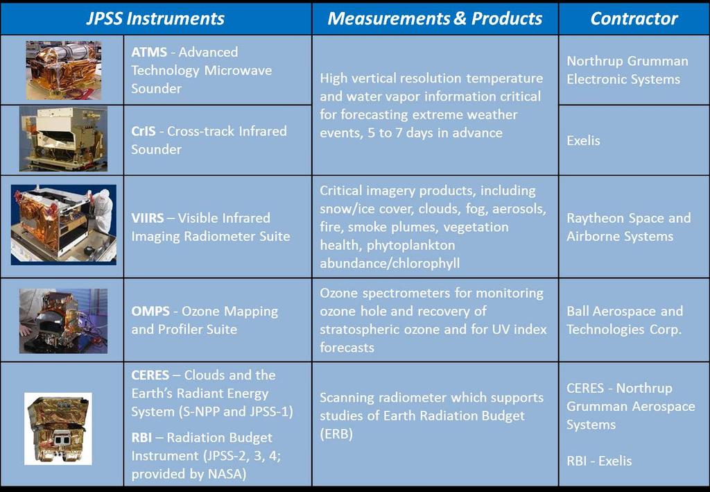
3 JPSS Instruments


4 JPSS Next Generation Instruments Advanced Technology Microwave Sounder Cross-track Infrared Sounder Higher resolution, wider swath, smaller gaps Resolution: OMPS vs SBUV/2 Ozone Mapping Profiler Suite 6x more vertical resolving power Provides global coverage ozone monitoring
5


6 August 21, 2015 NUCAPS CO Trajectory Forecasts AM NUCAPS low-trop CO AM NUCAPS mid-trop CO VIIRS True Color Imagery EPA Air Quality Index (AQI) 6 Credit: Brad Pierce VIIRS AOD EDR NUCAPS CO shows that most of the smoke over ND/ SD/MN is aloft and will not impact the surface
7 Spectral Differences: ATMS vs. AMSU/MHS AMSU/MHS ATMS MHS AMSU-A Ch GHz Pol Ch GHz Pol QV QV QV QV QV QH QH QV QH ± QH ± QH QH QH QV QH QH QH 9 fo = QH 10 fo = QH 10 fo ± QH 11 fo±0.3222±0.217 QH 11 fo±0.3222±0.048 QH 12 fo± ± fo ±0.3222± fo± ± fo±0.3222± QV QH QH 13 fo±0.3222±0.022 QH QH 14 fo± ±0.010 QH 15 fo± ± QV QV QV QH ± 1 QH ± 7 QH QH QH ATMS has 22 channels and AMSU/MHS have 20, with polarization differences between some channels QV = Quasi-vertical; polarization vector is parallel to the scan plane at nadir QH = Quasi-horizontal; polarization vector is perpendicular to the scan plane at nadir Exact match to AMSU/MHS Only Polarization different Unique Passband Unique Passband, and Pol. different from closest AMSU/MHS channels ± 3 QH ± 4.5 QH QV ± 3 QH ± 1.8 QH 7

8 8


, 11-22-2011")
9 JPSS Next Generation Instruments The Visible Infrared Imaging Radiometer Suite offers more spectral bands, higher resolution, wider swath and greater accuracy, resulting in a large number of products. NPP VIIRS NOAA-19 AVHRR Entire Antarctica observed in 12 hrs. VIIRS RGB (True Color), R: M05 (0.672 µm), G: M04 (0.555 µm), B: M02 (0.445 µm)

10 Comparison of Imagery Bands at Nadir meted.ucar.edu


11 Comparing MODIS (250m) to VIIRS (375m) Edge of Scan


 and")

 DNB Ice")
12 OMPS Aerosols from Fires JPSS provides a wide range of capabilities Microwave provides temperature and moisture soundings in cloudy conditions and rainfall rates, sea ice, snow, surface temperature Infrared provides high vertical resolution temperature and moisture soundings in clear and cloud corrected regions; atmospheric chemistry - CO, CH4, SO2, and cloud products Temperature X-Section Polar Vortex OMP- Volcano SO2 degassing Visible (day & night) and Infrared Imagery (including deep blue channels) chlorophyll, cloud imagery, cloud products, SST, Active Fires, Smoke, Aerosols, land products, Snow, Ice, oil spills at exceptional resolution/global coverage Algae in Lake Erie UV - ozone - Aerosols over bright surfaces, SO2 plumes, NOx (air quality) DNB Ice detection


13 Improvements in forecasting Relative Humidity Vertical Slice ATMS only ATMS & CrIS
14


15 NUCAPS Evaluated in NWS Hazardous Weather Testbed (HWT) Background What is the HWT: a joint testbed in Norman OK managed by the NWS Storm Prediction Center, the NWS Weather Forecast Office and the National Severe Storms Laboratory Purpose: plan and execute operational tests focused on national hazardous weather needs Spring Experiment: annual, 5-week test periods. Researchers, forecasters, and broadcast meteorologists evaluate emerging research concepts and tools through experimental forecast and warning generation exercises. NUCAPS was a key focus area in the Spring Experiment 2015 Waiting for deep convection to start. Denver s 18z special sounding showed a strong inversion around 700mb. The 20Z NUCAPS showed the lower levels not quite fully mixed. NUCAPS increased confidence that deep convection would occur but not quite yet. (comment edited) Examples of Forecaster feedback NUCAPS sounding shows the presence of a cold pocket aloft and relatively low precipitable water values around a half an inch confirm elevated convection along with the scattered reports of severe hail in eastern Idaho. A VIIRS Satellite Pass at 1944Z provided a NUCAPS Profile near some developing storms in Texas. It provided a nice snapshot of the atmosphere in between [radiosonde] soundings.


 enables the")


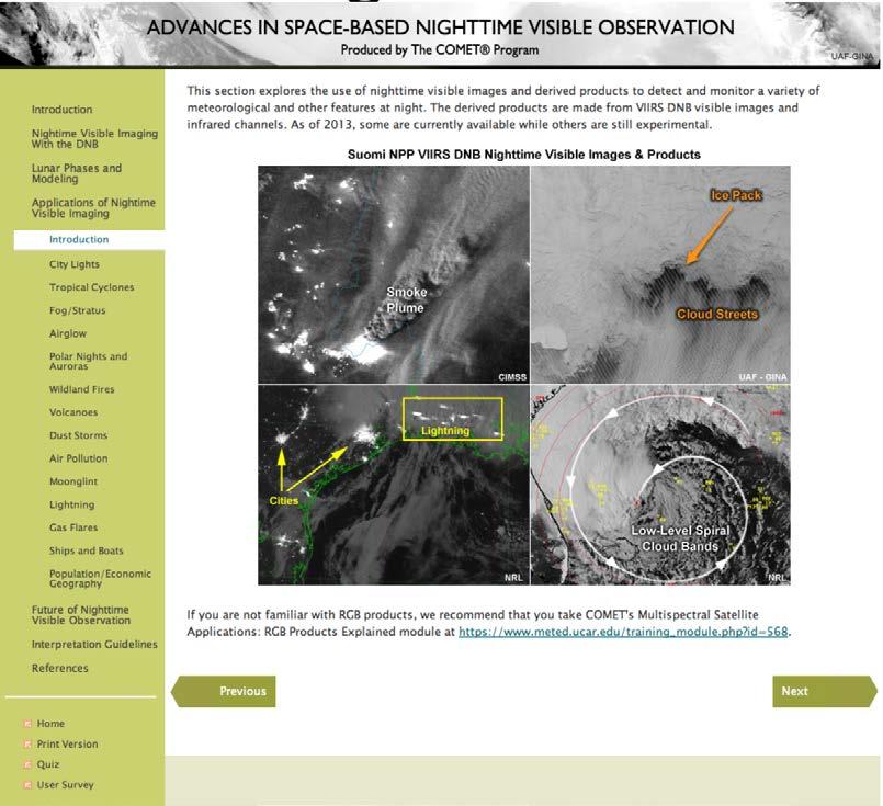
16 JPSS Night Imaging IR DNB + IR Chukchi Sea Hawaii RUSSIA Visible light to scatter through optically thin clouds (opaque at thermal infrared bands) enables the VIIRS DNB to image lower atmosphere and surface features not possible by any other instrument (Courtesy Steve Miller CIRA)

17 VIIRS Day Night Band 1647Z on October 31, 2013 Talcoban City Talcoban City Cebu City Clouds Tagbiaran City


18 VIIRS Day Night Band 1719Z on November 9, 2013 Clouds Talcoban City Talcoban City Cebu City Tagbiaran City


19 JPSS: Integral to 3-Orbit Global Polar Coverage JPSS implements U.S. Space Policy and international agreements to ensure global coverage. METOP NOAA s polar satellite covers the afternoon orbit, EUMETSAT s satellite covers the mid-morning orbit and DoD covers the early morning orbit. Suomi NPP / JPSS-1/JPSS-2 DMSP DoD Follow-on The data from these three orbits are fundamental to the 3-7 day forecast to provide advanced warning of severe weather, as well as environmental monitoring. JAXA provides microwave imagery used for a variety of applications; most importantly of precipitation in areas not covered by radar. JPSS provides observational continuity for the afternoon orbit JAXA GCOM-W1 Local Equatorial Crossing Time 19


20 Comparisons between AMSR2 and ATMS precipitation Rain rates from AMSR2 and ATMS within minutes after satellites fly over GCOM-W1 AMSR-2 (top), S-NPP ATMS (bottom) 06:30-07:00 UTC 7 April 2014 Notice the higher spatial resolution of AMSR2 compared to ATMS 20 20

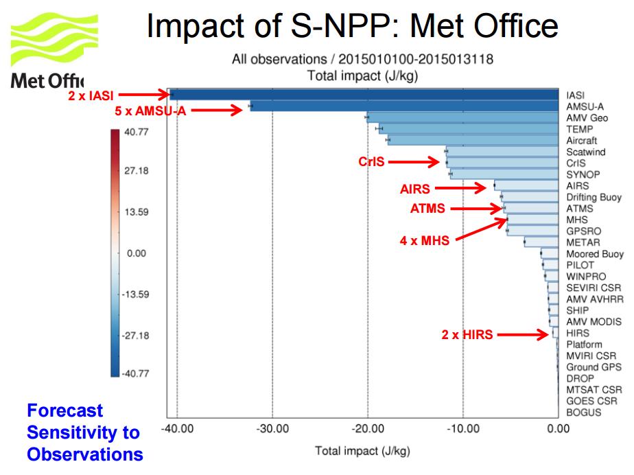
21 Driving requirements are global coverage of a wide range of environmental parameters with improved latency and high accuracy and reliability JPSS SNPP Polar region latency improved from 2 hours to 10 minutes 95% of the data is within 50 minutes (taking into account BUFR conversion, etc.) Between degrees latitude ~ 30 minutes Actual performance will be 50% better than specification

 System Guam, Honolulu, Fairbanks, Monterey, Madison, NYC, Miami,")
22 NOAA supported direct readout sites Currently antennas at Hawaii, Alaska, Monterey and Wisconsin, are being used routinely by weather forecast offices using AWIPS s Local Data Acquisition and Dissemination (LDAD) System Guam, Honolulu, Fairbanks, Monterey, Madison, NYC, Miami, Mayaguez (PR)

23 Polar Satellite Launch Schedule 23
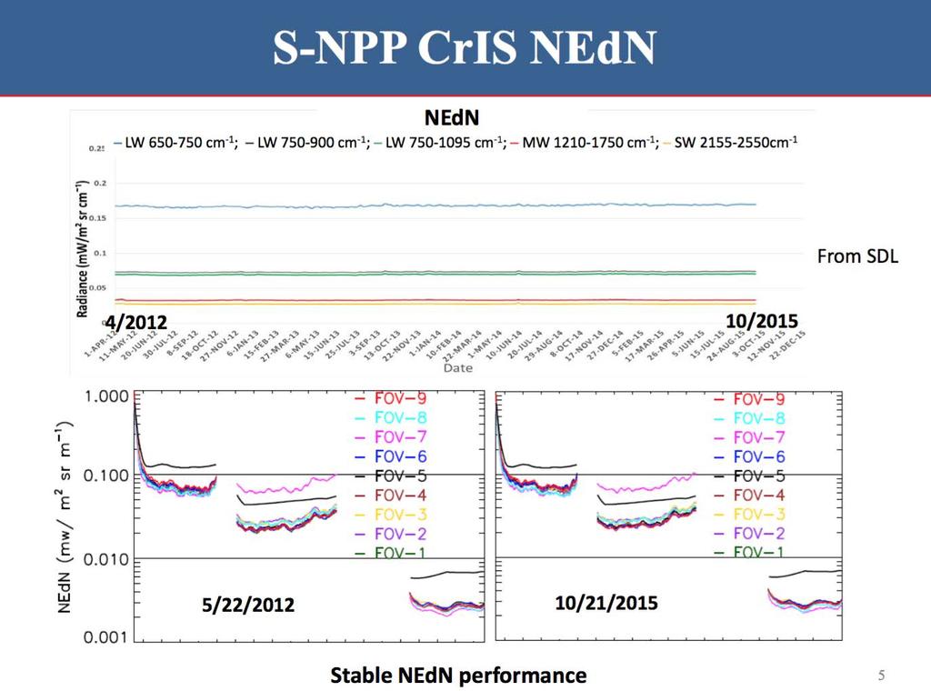
24 ATMS is outperforming AMSU in noise and long-term stability SNPP ATMS channel 8 - upper tropospheric channel When ATMS is averaged to AMSU spatial resolution the noise is reduced by a factor of 3 equivalent AMSU channel 7 Impact to NWP degrades over time because noise increases 24
25 25

26 26
27 27

28 Credit: Tobin 28


29 Mission Status S-NPP 4 years on orbit - October 28 Rapid data product transition to operational use Primary for weather since 1 MAY 2014 Excellent health and data availability JPSS-1 Integrated satellite test phase On track for early 2017 launch JPSS-2 Instrument parts/assembly phase Spacecraft kick-off phase JPSS-1 Spacecraft Clouds and the Earth s Radiant Energy System Ozone Mapping Profiler Suite Advanced Technology Microwave Sounder Cross-track Infrared Sounder Visible Infrared Imaging Radiometer Suite 29

30 JPSS Performance for Users Data Products Cal/Val and quality Three maturity levels Traceability to NIST standards Constant quality monitoring Transition to enterprise algorithms JPSS inherited NOAA legacy and NPOESS heritage Developed sustainable / maintainable/compatible suite User Focused Improvements Full spectrum CrIS, direct readout improvements Program Science -user readiness/risk reduction to enable quicker/broader utilization Half orbit latency, 17km resolution OMPS introduced with JPSS-1 30

31 SNPP VIIRS Aerosol Optical Thickness (AOT) Retrieval March 1, 2013 Operational IDPS AOT product has data gaps over bright surfaces and other regions where incorrect spectral surface reflectance ratios used in the algorithm lead to negative retrievals. IDPS Enterprise algorithm combines GOES-R ABI dark target algorithm for vegetated surfaces with atmospheric correction approach using spatially varying spectral surface reflectance ratio database for bright surfaces to improve spatial coverage. Enterprise Look for improved coverage in the Enterprise algorithm retrievals over desert regions in Africa, middle East, and other regions in Asia AOT Courtesy of H. Liu (IMSG), H. Zhang (IMSG), I. Laszlo (STAR), and S. Kondragunta (STAR)
32 Summary Substantial Progress in 5 years since program started Program Base-lined to Focus on Weather mission 5 instrument suite; S-NPP, JPSS-1, JPSS-2 Missions, Block 2 Ground development Four years of S-NPP operations, observatory working well, excellent user feedback Focus on Users Rapid user readiness, extensive calibration/ validation, risk reduction Increased performance Plan for Continuity Impact Mitigations Robust plan Two new missions requested: PFO/ JPSS-3, JPSS-4 32


33 Thank You 33
JPSS GEONETCAST REQUIREMENTS DISCUSSION
 Joint Polar Satellite System (JPSS) JPSS GEONETCAST REQUIREMENTS DISCUSSION Mitch Goldberg Program Scientist Joint Polar Satellite System National Environmental Satellite, Data, and Information Service
Joint Polar Satellite System. 3 rd Post-EPS User Consultation Workshop Mike Haas
 3 rd Post-EPS User Consultation Workshop Mike Haas Overview Introduction - Policy Drivers - Management System Description - Space Segment - Ground Segment Partnerships Status Benefits 2 Introduction (Policy
NESDIS Polar (Region) Products and Plans. Jeff Key NOAA/NESDIS Madison, Wisconsin USA
 Products and Plans. Jeff Key NOAA/NESDIS Madison, Wisconsin USA") NESDIS Polar (Region) Products and Plans Jeff Key NOAA/NESDIS Madison, Wisconsin USA WMO Polar Space Task Group, 2 nd meeting, Geneva, 12 14 June 2012 Relevant Missions and Products GOES R ABI Fractional
NESDIS Polar (Region) Products and Plans Jeff Key NOAA/NESDIS Madison, Wisconsin USA WMO Polar Space Task Group, 2 nd meeting, Geneva, 12 14 June 2012 Relevant Missions and Products GOES R ABI Fractional
JPSS. Suomi NPP* satellite, JPSS-1 satellite, and JPSS-2 satellite Four primary instruments (ATMS, CrIS, VIIRS, OMPS)
") Operational and Research Applications from the Joint Polar Satellite System (JPSS) Nove be 200 2014 0 November AOMSUC-5 Mitch Goldberg, JPSS Program Scientist Presented by: Lihang Zhou, JPSS STAR (JSTAR)
Operational and Research Applications from the Joint Polar Satellite System (JPSS) Nove be 200 2014 0 November AOMSUC-5 Mitch Goldberg, JPSS Program Scientist Presented by: Lihang Zhou, JPSS STAR (JSTAR)
JPSS Overview.
 JPSS Overview Mitch Goldberg, JPSS Program Scientist Joint Polar Satellite System National Environmental Satellite, Data, and Information Service National Oceanic and Atmospheric Administration September
Interpretation of Polar-orbiting Satellite Observations. Atmospheric Instrumentation
 Interpretation of Polar-orbiting Satellite Observations Outline Polar-Orbiting Observations: Review of Polar-Orbiting Satellite Systems Overview of Currently Active Satellites / Sensors Overview of Sensor
McIDAS support of Suomi-NPP /JPSS and GOES-R L2
 McIDAS support of Suomi-NPP /JPSS and GOES-R L2 William Straka III 1 Tommy Jasmin 1, Bob Carp 1 1 Cooperative Institute for Meteorological Satellite Studies, Space Science and Engineering Center, University
Recent Update on MODIS C6 and VIIRS Deep Blue Aerosol Products
 Recent Update on MODIS C6 and VIIRS Deep Blue Aerosol Products N. Christina Hsu, Photo taken from Space Shuttle: Fierce dust front over Libya Corey Bettenhausen, Andrew M. Sayer, and Rick Hansell Laboratory
Instrumentation planned for MetOp-SG
 Instrumentation planned for MetOp-SG Bill Bell Satellite Radiance Assimilation Group Met Office Crown copyright Met Office Outline Background - the MetOp-SG programme The MetOp-SG instruments Summary Acknowledgements:
NOAA Direct Broadcast Data Initiative to Meet NWP Latency Requirements
 Prepared by M. Goldberg Agenda Item: II/2 Discussed in WG-II NOAA Direct Broadcast Data Initiative to Meet NWP Latency Requirements Summary of the Working Paper Action 40.18: CGMS Agencies to support fast
Lecture 4b: Meteorological Satellites and Instruments. Acknowledgement: Dr. S. Kidder at Colorado State Univ.
 Lecture 4b: Meteorological Satellites and Instruments Acknowledgement: Dr. S. Kidder at Colorado State Univ. US Geostationary satellites - GOES (Geostationary Operational Environmental Satellites) US
New Generation Aerosol Satellite Products for Air Quality Mapping and Analysis
 New Generation Aerosol Satellite Products for Air Quality Mapping and Analysis Amy K. Huff Penn State University 2017 MARAMA Air Quality Monitoring Training Workshop November 3, 2017 Satellites Identify
Country Report - Singapore
 Country Report - Singapore The 5th Meeting of the Coordinating Group Vladivostok city, Russky Island, Russia Far Eastern Federal University of the RA II WIGOS Satellite Project 21 October 2017 Outline
F O U N D A T I O N A L C O U R S E
 F O U N D A T I O N A L C O U R S E December 6, 2018 Satellite Foundational Course for JPSS (SatFC-J) F O U N D A T I O N A L C O U R S E Introduction to Microwave Remote Sensing (with a focus on passive
NOAA Direct Broadcast Real-Time Network Status
 NOAA Direct Broadcast Real-Time Network Status Liam Gumley (CIMSS/SSEC/UW-Madison) Mitch Goldberg (JPSS/NOAA) WMO DBNET Operators Meeting Sept 2016 Overview NOAA antennas for Honolulu, Madison, Miami,
NOAA Report. Hal Bloom Mitch Goldberg NOAA/NESDIS
 NOAA Report Hal Bloom Mitch Goldberg NOAA/NESDIS Summary of Major Events at NESDIS (of interest to ITSC) NOAA/NASA addressing NPOESS Climate Sensors Letter of agreement signed with JAXA on GCOM interagency
NOAA Cal/Val Progress Update
 NOAA Cal/Val Progress Update Xi Shao 1,2 and Changyong Cao 2 1. University of Maryland 2. NOAA/NESDIS/STAR With contributions from NOAA/NESDIS/STAR Scientists Presented at the WGCV-36, Shanghai, China,
EPS-SG Candidate Observation Missions
 EPS-SG Candidate Observation Missions 3 rd Post-EPS User Consultation Workshop Peter Schlüssel Slide: 1 EPS-SG benefits to activities of NMSs Main Payload High-Resolution Infrared Sounding Microwave Sounding
NOAA Operational Satellites -Program Update-
 NOAA Operational Satellites -Program Update- (GOES-R Series, JPSS & COSMIC-2) Briefing to the Expert Team on Satellite Systems (ET-SAT-11) Geneva, 4-6 April 2017 Sid Ahmed Boukabara NOAA/NESDIS Center
MONITORING WEATHER AND CLIMATE FROM SPACE
 MONITORING WEATHER AND CLIMATE FROM SPACE EUMETSAT Report on New Services Anders Meier Soerensen New X/L-band antenna, Greenland Athens: New 3.0 m L/X-band antenna New 2.4 m L/Xband antenna Installations
Extending the Deep Blue aerosol record from SeaWiFS and MODIS to NPP-VIIRS
 Extending the Deep Blue aerosol record from SeaWiFS and MODIS to NPP-VIIRS Andrew M. Sayer, N. Christina Hsu (PI), Corey Bettenhausen, Jaehwa Lee Climate & Radiation Laboratory, NASA Goddard Space Flight
Snowfall Detection and Rate Retrieval from ATMS
 Snowfall Detection and Rate Retrieval from ATMS Jun Dong 1, Huan Meng 2, Cezar Kongoli 1, Ralph Ferraro 2, Banghua Yan 2, Nai-Yu Wang 1, Bradley Zavodsky 3 1 University of Maryland/ESSIC/Cooperative Institute
The Transition of Atmospheric Infrared Sounder Total Ozone Products to Operations
 The Transition of Atmospheric Infrared Sounder Total Ozone Products to Operations Emily Berndt 1, Bradley Zavodsky 2, Gary Jedlovec 2 1 NASA Postdoctoral Program Marshall Space Flight Center, Huntsville,
CMA Consideration on early-morning orbit satellite
 CMA Consideration on early-morning orbit satellite National Satellite Meteorological Center,CMA Yang Jun CGMS 40 in Lugano, 5-9 Nov., 2012 Outline Background Gap analysis on the sounding data coverage
Satellite observation of atmospheric dust
 Satellite observation of atmospheric dust Taichu Y. Tanaka Meteorological Research Institute, Japan Meteorological Agency 11 April 2017, SDS WAS: Dust observation and modeling @WMO, Geneva Dust observations
Observations Team: Satellite Observation Update. John Knaff NOAA/NESDIS Regional and Mesoscale Meteorology Branch
 Observations Team: Satellite Observation Update John Knaff NOAA/NESDIS Regional and Mesoscale Meteorology Branch 1 FY12 Satellite Milestones: i. CIRA/RAMMB continue maintaining and populating real-time
NOAA Report. Mitch Goldberg. NOAA/NESDIS Center for Satellite Applications and Research
 NOAA Report Mitch Goldberg NOAA/NESDIS Center for Satellite Applications and Research NOAA JOINT POLAR SATELLITE PROGRAM Mission Support to NOAA Programs Ecosystems NOAA CoastWatch Program Real-time distribution
Lecture 19: Operational Remote Sensing in Visible, IR, and Microwave Channels
 MET 4994 Remote Sensing: Radar and Satellite Meteorology MET 5994 Remote Sensing in Meteorology Lecture 19: Operational Remote Sensing in Visible, IR, and Microwave Channels Before you use data from any
Arctic Weather Every 10 Minutes: Design & Operation of ABI for PCW
 Arctic Weather Every 10 Minutes: Design and Operation of ABI for PCW Dr. Paul C. Griffith and Sue Wirth 31st Space Symposium, Technical Track, Colorado Springs, Colorado This document is not subject to
Retrieving Snowfall Rate with Satellite Passive Microwave Measurements
 Retrieving Snowfall Rate with Satellite Passive Microwave Measurements Huan Meng 1, Ralph Ferraro 1, Banghua Yan 1, Cezar Kongoli 2, Nai-Yu Wang 2, Jun Dong 2, Limin Zhao 1 1 NOAA/NESDIS, USA 2 Earth System
The NOAA/NESDIS/STAR IASI Near Real-Time Product Processing and Distribution System
 The NOAA/NESDIS/STAR Near Real-Time Product Processing and Distribution System W. Wolf 2, T. King 1, Z. Cheng 1, W. Zhou 1, H. Sun 1, P. Keehn 1, L. Zhou 1, C. Barnet 2, and M. Goldberg 2 1 QSS Group Inc,
The NOAA Unique CrIS/ATMS Processing System (NUCAPS): first light retrieval results
: first light retrieval results") The NOAA Unique CrIS/ATMS Processing System (NUCAPS): first light retrieval results A. Gambacorta (1), C. Barnet (2), W.Wolf (2), M. Goldberg (2), T. King (1), X. Ziong (1), N. Nalli (3), E. Maddy (1),
The NOAA Unique CrIS/ATMS Processing System (NUCAPS): first light retrieval results A. Gambacorta (1), C. Barnet (2), W.Wolf (2), M. Goldberg (2), T. King (1), X. Ziong (1), N. Nalli (3), E. Maddy (1),
Direct Readout at the Meteorological Service of Canada
 Direct Readout at the Meteorological Service of Canada CSPP Users Meeting 2015 Darmstadt, Germany April 14-16, 2015 David Bradley Manager, Earth Observation and Geomatics Meteorological Service of Canada
International Cooperation in Operational Environmental Satellites: The U.S. Experience
 Committee on the Peaceful Uses of Outer Space Science and Technology Sub committee Forty seventh session February 17, 2010 Vienna, Austria International Cooperation in Operational Environmental Satellites:
Feature-tracked 3D Winds from Satellite Sounders: Derivation and Impact in Global Models
 Feature-tracked 3D Winds from Satellite Sounders: Derivation and Impact in Global Models David Santek 1, A.-S. Daloz 1, S. Tushaus 1, M. Rogal 1, W. McCarty 2 1 Space Science and Engineering Center/University
Jun Mitch Goldberg %, Pei Timothy J. Schmit &, Jinlong Zhenglong and Agnes
 Progress on the assimilation of advanced IR sounder radiances in cloudy skies Jun Li @, Mitch Goldberg %, Pei Wang @#, Timothy J. Schmit &, Jinlong Li @, Zhenglong Li @, and Agnes Lim @ @CIMSS, University
Using the NOAA Unique CrIS/ATMS Processing System (NUCAPS) to explore hyper spectral sounding capabilities during extreme events
 to explore hyper spectral sounding capabilities during extreme events") Using the NOAA Unique CrIS/ATMS Processing System (NUCAPS) to explore hyper spectral sounding capabilities during extreme events Antonia Gambacorta (1), Chris Barnet (1),Mitch Goldberg (2), Ryan Spackman
Using the NOAA Unique CrIS/ATMS Processing System (NUCAPS) to explore hyper spectral sounding capabilities during extreme events Antonia Gambacorta (1), Chris Barnet (1),Mitch Goldberg (2), Ryan Spackman
Some NOAA Products that Address PSTG Satellite Observing Requirements. Jeff Key NOAA/NESDIS Madison, Wisconsin USA
 Some NOAA Products that Address PSTG Satellite Observing Requirements Jeff Key NOAA/NESDIS Madison, Wisconsin USA WMO Polar Space Task Group, 4 th meeting, Greenbelt, 30 September 2014 Relevant Missions
Next generation of EUMETSAT microwave imagers and sounders: new opportunities for cloud and precipitation retrieval
 Next generation of EUMETSAT microwave imagers and sounders: new opportunities for cloud and precipitation retrieval Christophe Accadia, Sabatino Di Michele, Vinia Mattioli, Jörg Ackermann, Sreerekha Thonipparambil,
APPENDIX 2 OVERVIEW OF THE GLOBAL PRECIPITATION MEASUREMENT (GPM) AND THE TROPICAL RAINFALL MEASURING MISSION (TRMM) 2-1
 AND THE TROPICAL RAINFALL MEASURING MISSION (TRMM) 2-1") APPENDIX 2 OVERVIEW OF THE GLOBAL PRECIPITATION MEASUREMENT (GPM) AND THE TROPICAL RAINFALL MEASURING MISSION (TRMM) 2-1 1. Introduction Precipitation is one of most important environmental parameters.
APPENDIX 2 OVERVIEW OF THE GLOBAL PRECIPITATION MEASUREMENT (GPM) AND THE TROPICAL RAINFALL MEASURING MISSION (TRMM) 2-1 1. Introduction Precipitation is one of most important environmental parameters.
Methane Sensing Flight of Scanning HIS over Hutchinson, KS, 31 March 2001
 Methane Sensing Flight of Scanning HIS over Hutchinson, KS, 31 March 2001 Hank Revercomb, Chris Moeller, Bob Knuteson, Dave Tobin, Ben Howell University of Wisconsin, Space Science and Engineering Center
Introducing VIIRS Aerosol Products
 1 Introducing VIIRS Aerosol Products Shobha Kondragunta NOAA/NESDIS Center for Satellite Applications and Research VIIRS Aerosol Cal/Val Team 2 Name Organization Major Task Kurt F. Brueske IIS/Raytheon
Satellite-derived Wind, Cloud, and Surface Products at Direct Broadcast Sites in the Antarctic and Arctic
 Satellite-derived Wind, Cloud, and Surface Products at Direct Broadcast Sites in the Antarctic and Arctic William Straka III +, Jeff Key*, Dave Santek +, Matthew Lazzara #, Liam Gumley +, Kathy Strabala
Improving Numerical Weather Forecasting for Ghana/West Africa
 Improving Numerical Weather Forecasting for Ghana/West Africa Amos T. Kabo-bah, PhD Head, Earth Observation Research and Innovation Centre University of Energy and Natural Resources Sunyani Ghana/West
Impact of assimilating the VIIRS-based CrIS cloudcleared radiances on hurricane forecasts
 Impact of assimilating the VIIRS-based CrIS cloudcleared radiances on hurricane forecasts Jun Li @, Pei Wang @, Jinlong Li @, Zhenglong Li @, Jung-Rim Lee &, Agnes Lim @, Timothy J. Schmit #, and Mitch
A New Microwave Snow Emissivity Model
 A New Microwave Snow Emissivity Model Fuzhong Weng 1,2 1. Joint Center for Satellite Data Assimilation 2. NOAA/NESDIS/Office of Research and Applications Banghua Yan DSTI. Inc The 13 th International TOVS
REVISION OF THE STATEMENT OF GUIDANCE FOR GLOBAL NUMERICAL WEATHER PREDICTION. (Submitted by Dr. J. Eyre)
") WORLD METEOROLOGICAL ORGANIZATION Distr.: RESTRICTED CBS/OPAG-IOS (ODRRGOS-5)/Doc.5, Add.5 (11.VI.2002) COMMISSION FOR BASIC SYSTEMS OPEN PROGRAMME AREA GROUP ON INTEGRATED OBSERVING SYSTEMS ITEM: 4 EXPERT
WORLD METEOROLOGICAL ORGANIZATION Distr.: RESTRICTED CBS/OPAG-IOS (ODRRGOS-5)/Doc.5, Add.5 (11.VI.2002) COMMISSION FOR BASIC SYSTEMS OPEN PROGRAMME AREA GROUP ON INTEGRATED OBSERVING SYSTEMS ITEM: 4 EXPERT
MONITORING WEATHER AND CLIMATE FROM SPACE
 1 EUM/TSS/VWG/15/801307, April 2015 MONITORING WEATHER AND CLIMATE FROM SPACE Evolution of the EUMETSAT Advanced Retransmission Service (EARS) Anders Soerensen EUMETSAT EUMETSAT Advanced Retransmission
Arising from headwaters around Mount Robson in the Rocky Mountains, the Fraser River starts as a fastmoving stream. The river angles northward around
 Arising from headwaters around Mount Robson in the Rocky Mountains, the Fraser River starts as a fastmoving stream. The river angles northward around the Columbia Mountains, picking up so much sediment
Operational systems for SST products. Prof. Chris Merchant University of Reading UK
 Operational systems for SST products Prof. Chris Merchant University of Reading UK Classic Images from ATSR The Gulf Stream ATSR-2 Image, ƛ = 3.7µm Review the steps to get SST using a physical retrieval
Global Precipitation Measurement Mission Overview & NASA Status
 Global Precipitation Measurement Mission Overview & NASA Status Gail Skofronick Jackson GPM Project Scientist (appointed 14 January 2014) Replacing Dr. Arthur Hou (1947-2013) NASA Goddard Space Flight
NOAA/NESDIS Tropical Web Page with LEO Satellite Products and Applications for Forecasters
 NOAA/NESDIS Tropical Web Page with LEO Satellite Products and Applications for Forecasters Sheldon Kusselson National Oceanic and Atmospheric Administration (NOAA) National Environmental Satellite Data
Combining Polar Hyper-spectral and Geostationary Multi-spectral Sounding Data A Method to Optimize Sounding Spatial and Temporal Resolution
 Combining Polar Hyper-spectral and Geostationary Multi-spectral Sounding Data A Method to Optimize Sounding Spatial and Temporal Resolution W. L. Smith 1,2, E. Weisz 1, and J. McNabb 2 1 University of
An Overview of the UW Hyperspectral Retrieval System for AIRS, IASI and CrIS
 An Overview of the UW Hyperspectral Retrieval System for AIRS, IASI and CrIS Nadia Smith a, Elisabeth Weisz b and William L. Smith Cooperative Institute for Meteorological Satellite Studies (CIMSS) Space
A two-season impact study of the Navy s WindSat surface wind retrievals in the NCEP global data assimilation system
 A two-season impact study of the Navy s WindSat surface wind retrievals in the NCEP global data assimilation system Li Bi James Jung John Le Marshall 16 April 2008 Outline WindSat overview and working
CGMS Baseline. Sustained contributions to the Global Observing System. Endorsed by CGMS-46 in Bengaluru, June 2018
 CGMS Baseline Sustained contributions to the Global Observing System Best Practices for Achieving User Readiness for New Meteorological Satellites Endorsed by CGMS-46 in Bengaluru, June 2018 CGMS/DOC/18/1028862,
Preparing for NOAA s Next Generation GOES-R & JPSS
 Preparing for NOAA s Next Generation GOES-R & JPSS Mark Paese Deputy Assistant Administrator NOAA Environmental Satellite & Information Service (NESDIS) WMO Cg-17: Ensuring User Readiness for New Generation
COORDINATION GROUP FOR METEOROLOGICAL SATELLITES AND GOFC-GOLD
 Coordination Group for Meteorological Satellites - CGMS COORDINATION GROUP FOR METEOROLOGICAL SATELLITES AND GOFC-GOLD Mitch Goldberg, CGMS co-liaison to CGMS Working group 2 satellite data and products
STATUS OF JAPANESE METEOROLOGICAL SATELLITES AND RECENT ACTIVITIES OF MSC
 STATUS OF JAPANESE METEOROLOGICAL SATELLITES AND RECENT ACTIVITIES OF MSC Daisaku Uesawa Meteorological Satellite Center, Japan Meteorological Agency Abstract MTSAT-1R is the current operational Japanese
NPP ATMS Instrument On-orbit Performance
 NPP ATMS Instrument On-orbit Performance K. Anderson, L. Asai, J. Fuentes, N. George Northrop Grumman Electronic Systems ABSTRACT The first Advanced Technology Microwave Sounder (ATMS) was launched on
Status report on current and future satellite systems by EUMETSAT Presented to CGMS-44, Plenary session, agenda item D.1
 Status report on current and future satellite systems by EUMETSAT Presented to CGMS-44, Plenary session, agenda item D.1 CGMS-44-EUMETSAT-WP-19.ppt, version 1 (# 859110), 8 June 2016 MISSION PLANNING YEAR...
Overview: Scope and Goals
 Overview: Scope and Goals Current operational NOAA instruments: AVHRR, HIRS, SBUV, GOES Imagers/Sounders; Non-NOAA satellites/sensors; Future: MetOP and NPP/NPOESS; GOES-R Assure Functionality of Current/Near-Future
Improving Tropical Cyclone Forecasts by Assimilating Microwave Sounder Cloud-Screened Radiances and GPM precipitation measurements
 Improving Tropical Cyclone Forecasts by Assimilating Microwave Sounder Cloud-Screened Radiances and GPM precipitation measurements Hyojin Han a, Jun Li a, Mitch Goldberg b, Pei Wang a,c, Jinlong Li a,
Recent improvements in the all-sky assimilation of microwave radiances at the ECMWF
 Recent improvements in the all-sky assimilation of microwave radiances at the ECMWF Katrin Lonitz, Alan Geer and many more katrin.lonitz@ecmwf.int ECMWF January 30, 2018 clear sky assimilation all-sky
EUMETSAT SAF NETWORK. Lothar Schüller, EUMETSAT SAF Network Manager
 1 EUMETSAT SAF NETWORK Lothar Schüller, EUMETSAT SAF Network Manager EUMETSAT ground segment overview METEOSAT JASON-2 INITIAL JOINT POLAR SYSTEM METOP NOAA SATELLITES CONTROL AND DATA ACQUISITION FLIGHT
The use of Direct Broadcast Processing System in Poland
 The use of Direct Broadcast Processing System in Poland B.Łapeta, P.Struzik Satellite Remote Sensing Department, Institute of Meteortology and Water Management National Reasearch Institute About IMWM-NRI
SATELLITE MONITORING OF THE CONVECTIVE STORMS
 SATELLITE MONITORING OF THE CONVECTIVE STORMS FORECASTERS POINT OF VIEW Michaela Valachová, EUMETSAT Workshop at ECMWF User Meeting Reading, 13 June 2017 Central Forecasting Office, Prague michaela.valachova@chmi.cz
FUTURE PLAN AND RECENT ACTIVITIES FOR THE JAPANESE FOLLOW-ON GEOSTATIONARY METEOROLOGICAL SATELLITE HIMAWARI-8/9
 FUTURE PLAN AND RECENT ACTIVITIES FOR THE JAPANESE FOLLOW-ON GEOSTATIONARY METEOROLOGICAL SATELLITE HIMAWARI-8/9 Toshiyuki Kurino Japan Meteorological Agency, 1-3-4 Otemachi Chiyodaku, Tokyo 100-8122,
Current and Upcoming NASA Hurricane Measurement Missions National Hurricane Conference
 NASA Science Mission Directorate Earth Science Division Applied Sciences Program Current and Upcoming NASA Hurricane Measurement Missions National Hurricane Conference April 18, 2017 Formulation Implementation
Lecture 4: Meteorological Satellites and Instruments. Acknowledgement: Dr. S. Kidder at Colorado State Univ.
 Lecture 4: Meteorological Satellites and Instruments Acknowledgement: Dr. S. Kidder at Colorado State Univ. Homework for the Spring Break: get some tangible, preliminary results for your final project.
MONITORING WEATHER AND CLIMATE FROM SPACE
 1 EUM/SEP/VWG/16/876485 Version 20 September 2016 MONITORING WEATHER AND CLIMATE FROM SPACE Evolution of the EUMETSAT Advanced Retransmission Service (EARS) EUMETSAT EUMETSAT Advanced Retransmission Service
EUMETSAT Polar System (EPS)
") EUMETSAT Polar System (EPS) Synergetic Operational Earth Observations with the EPS/MetOp System Dieter Klaes EPS Programme Scientist Outline 1. Introduction 2. EPS System and Observations 3. Outlook 1.
EUMETSAT Polar System (EPS) Synergetic Operational Earth Observations with the EPS/MetOp System Dieter Klaes EPS Programme Scientist Outline 1. Introduction 2. EPS System and Observations 3. Outlook 1.
Uncertainty of Atmospheric Temperature Trends Derived from Satellite Microwave Sounding Data
 Uncertainty of Atmospheric Temperature Trends Derived from Satellite Microwave Sounding Data Fuzhong Weng NOAA Center for Satellite Applications and Research and Xiaolei Zou University of University November
POLAR WINDS FROM VIIRS
 POLAR WINDS FROM VIIRS Jeff Key 1, Richard Dworak, David Santek, Wayne Bresky 3, Steve Wanzong, Jaime Daniels 4, Andrew Bailey 3, Christopher Velden, Hongming Qi, Pete Keehn 5, and Walter Wolf 4 1 NOAA/National
Status of the Sentinel-5 Precursor Presented by C. Zehner S5p, S4, and S5 Missions Manager - ESA
 Status of the Sentinel-5 Precursor Presented by C. Zehner S5p, S4, and S5 Missions Manager - ESA European response to global needs: to manage the environment, to mitigate the effects of climate change
History of Aerosol Remote Sensing. Mark Smithgall Maria Zatko 597K Spring 2009
 History of Aerosol Remote Sensing Mark Smithgall Maria Zatko 597K Spring 2009 Aerosol Sources Anthropogenic Biological decomposition from fertilizer and sewage treatment (ex. ammonium) Combustion of fossil
Global Satellite Products & Services for Agricultural and Vegetation Health
 Global Satellite Products & Services for Agricultural and Vegetation Health Presented at the WMO Expert Meeting on National Early Warning System for Agricultural Weather Management George Mason University
The current status of FY-3D
 The current status of FY-3D Xiang Fang National Satellite Meteorological Center, China Meteorological Administration (NSMC/CMA) OUTLINE Overview Key instruments onboard FY-3D Products and data service
ASCAT NRT Data Processing and Distribution at NOAA/NESDIS
 ASCAT NRT Data Processing and Distribution at NOAA/NESDIS Paul S. Chang, Zorana Jelenak, Seubson Soisuvarn, Qi Zhu Gene Legg and Jeff Augenbaum National Oceanic and Atmospheric Administration (NOAA) National
EARS-ATMS, EARS-CrIS and EARS-VIIRS: Three New Regional Services
 EARS-, EARS- and EARS-VIIRS: Three New Regional Services Anders Meier Soerensen, Ester Rojo, Thomas Heinemann, Michele Burla, Susanne Dieterle EUMETSAT Monitoring weather and climate from space Meteosat-7
MSG system over view
 MSG system over view 1 Introduction METEOSAT SECOND GENERATION Overview 2 MSG Missions and Services 3 The SEVIRI Instrument 4 The MSG Ground Segment 5 SAF Network 6 Conclusions METEOSAT SECOND GENERATION
Comparison of NASA AIRS and MODIS Land Surface Temperature and Infrared Emissivity Measurements from the EOS AQUA platform
 Comparison of NASA AIRS and MODIS Land Surface Temperature and Infrared Emissivity Measurements from the EOS AQUA platform Robert Knuteson, Steve Ackerman, Hank Revercomb, Dave Tobin University of Wisconsin-Madison
International TOVS Study Conference-XV Proceedings
 Relative Information Content of the Advanced Technology Microwave Sounder, the Advanced Microwave Sounding Unit and the Microwave Humidity Sounder Suite Motivation Thomas J. Kleespies National Oceanic
Report on CIMSS Participation in the Utility of GOES-R Instruments for Hurricane Data Assimilation and Forecasting
 Report on CIMSS Participation in the Utility of GOES-R Instruments for Hurricane Data Assimilation and Forecasting Award Number: NA10NES4400010 Award Period: 06/01/2010-05/31/2014 Program Office: NESDIS
IDEA. from research to routine
 IDEA. from research to routine A collaboration between NASA, EPA, NOAA and CIMSS Cooperative Institute for Meteorological Satellite Studies Infusing satellite Data in Environmental Applications (IDEA)
Feature-tracked 3D Winds from Satellite Sounders: Derivation and Impact in Global Models
 Feature-tracked 3D Winds from Satellite Sounders: Derivation and Impact in Global Models David Santek, Anne-Sophie Daloz 1, Samantha Tushaus 1, Marek Rogal 1, Will McCarty 2 1 Space Science and Engineering
How does NASA study hurricanes? 17 August 2015, by Max Gleber
 How does NASA study hurricanes? 17 August 2015, by Max Gleber Hurricanes are the most powerful weather event on Earth. NASA's expertise in space and scientific exploration contributes to essential services
EUMETSAT STATUS AND PLANS
 1 EUM/TSS/VWG/15/826793 07/10/2015 EUMETSAT STATUS AND PLANS François Montagner, Marine Applications Manager, EUMETSAT WMO Polar Space Task Group 5 5-7 October 2015, DLR, Oberpfaffenhofen PSTG Strategic
VIIRS SDR Cal/Val: S-NPP Update and JPSS-1 Preparations
 VIIRS SDR Cal/Val: S-NPP Update and JPSS-1 Preparations VIIRS SDR Cal/Val Posters: Xi Shao Zhuo Wang Slawomir Blonski ESSIC/CICS, University of Maryland, College Park NOAA/NESDIS/STAR Affiliate Spectral
Space Studies Board Meeting Mary E. Kicza
 Space Studies Board Meeting Mary E. Kicza Assistant Administrator for Satellites and Information Services May 14, 2009 1 Summary Budget Update FY 2009 Stimulus (ARRA) FY 2009 Omnibus FY 2010 President
The NASA Short-term Prediction Research and Transition (SPoRT) Center:
 Center:") The NASA Short-term Prediction Research and Transition (SPoRT) Center: Opportunities for Collaboration in the Great Lakes Region Andrew Molthan NASA Marshall Space Flight Center, Huntsville, AL andrew.molthan@nasa.gov
The NASA Short-term Prediction Research and Transition (SPoRT) Center: Opportunities for Collaboration in the Great Lakes Region Andrew Molthan NASA Marshall Space Flight Center, Huntsville, AL andrew.molthan@nasa.gov
Masahiro Kazumori, Takashi Kadowaki Numerical Prediction Division Japan Meteorological Agency
 Development of an all-sky assimilation of microwave imager and sounder radiances for the Japan Meteorological Agency global numerical weather prediction system Masahiro Kazumori, Takashi Kadowaki Numerical
Latest Development on the NOAA/NESDIS Snowfall Rate Product
 Latest Development on the NOAA/NESDIS Snowfall Rate Product Jun Dong 1, Cezar Kongoli 1, Huan Meng 2, Ralph Ferraro 2, Banghua Yan 2, Nai-Yu Wang 1, Bradley Zavodsky 3 1 University of Maryland/ESSIC/Cooperative
EOS Direct Broadcast Real-Time Products for the US National Weather Service
 EOS Direct Broadcast Real-Time Products for the US National Weather Service Liam E. Gumley,, K. Strabala, J. Gerth,, S. Bachmeier, R. Dengel,, S. Dutcher, and J. Robaidek Liam.Gumley@ssec.wisc.edu University
Back to basics: From Sputnik to Envisat, and beyond: The use of satellite measurements in weather forecasting and research: Part 1 A history
 Back to basics: From Sputnik to Envisat, and beyond: The use of satellite measurements in weather forecasting and research: Part 1 A history Roger Brugge 1 and Matthew Stuttard 2 1 NERC Data Assimilation
OPTIMIZATION OF SUN-SYNCHRONOUS ORBITAL PLANES Report on Studies Conducted in the United States. Submitted by Dr. Lars Peter Riishojgaard, USA
 Prepared by WMO Agenda Item: III/3.2 & IV.1 Discussed in: WG III & Plenary OPTIMIZATION OF SUN-SYNCHRONOUS ORBITAL PLANES Report on Studies Conducted in the United States Submitted by Dr. Lars Peter Riishojgaard,
EUMETSAT NEWS. Marianne König.
 EUMETSAT NEWS Marianne König marianne.koenig@eumetsat.int www.eumetsat.int MUG 2010 26 Member States & 5 Cooperating States * Member States AUSTRIA BELGIUM CROATIA CZECH REPUBLIC DENMARK FINLAND FRANCE
EUMETSAT PLANS. K. Dieter Klaes EUMETSAT Darmstadt, Germany
 EUMETSAT PLANS K. Dieter Klaes EUMETSAT Darmstadt, Germany 1. INTRODUCTION The European Organisation for the Exploitation of Meteorological Satellites (EUMETSAT), contributes to the World Weather Watch
Status of VIIRS Reflective Solar Bands On-orbit Calibration and Performance
 EOS Status of VIIRS Reflective Solar Bands On-orbit Calibration and Performance X. Xiong 1, J. Fulbright 2, N. Lei 2, J. Sun 2, Z. Wang 2, and J. McIntire 2 1. NASA/GSFC, Greenbelt, MD 20771, USA 2. Sigma
Advancing Environmental Intelligence via Next-Generation Satellite Observations
 Advancing Environmental Intelligence via Next-Generation Satellite Observations Steven D. Miller Cooperative Institute for Research in the Atmosphere 11 th NOAA/NESDIS CoRP Science Symposium 16 September