JPSS GEONETCAST REQUIREMENTS DISCUSSION
|
|
|
- George Hunt
- 5 years ago
- Views:
Transcription
1 Joint Polar Satellite System (JPSS) JPSS GEONETCAST REQUIREMENTS DISCUSSION Mitch Goldberg Program Scientist Joint Polar Satellite System National Environmental Satellite, Data, and Information Service U.S. National Oceanic and Atmospheric Administration U.S. Department of Commerce NSC JPSS Training Workshop July


2 GEONETCAST Polar Products NSC JPSS Training Workshop July

3 JPSS Program Data Products NSC JPSS Training Workshop July

4 Multiple Orbits Create Better Coverage NSC JPSS Training Workshop July

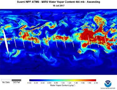
5 Data Fusion of 5 microwave sounders to produce hourly total precipitable water From Tony Wimmers - MIMIC TPW2 NSC JPSS Training Workshop July
6 JPSS Program Data Products NSC JPSS Training Workshop July


7 Advanced Technology Microwave Sounder (ATMS) Resolution: ATMS vs. AMSU Sounding data provides: 3-D temperature and moisture profiles Rainfall rates Snow/ice information Sounding data improves: Short- and medium-term forecasting Storm tracking Higher resolution Wider swath Much smaller gaps between passes Rainfall rates during Hurricane Sandy NSC JPSS Training Workshop July


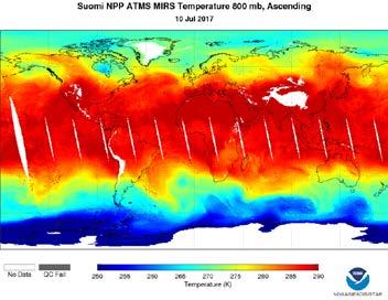
8 ATMS Measures Vertical Profiles NSC JPSS Training Workshop July


9 ATMS Monitors Snow NSC JPSS Training Workshop July

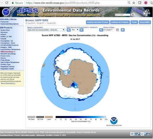
10 ATMS Monitors Ice NSC JPSS Training Workshop July


11 VIIRS image MiRS V11 Rainfall: Typhoon Neoguri on 7 July 2014 Liquid Water Path (RWP+CLW), mm SNPP/ATMS data Cyclone impacted Okinawa on 8 July Miyazaki Prefecture Rain Rate, mm/h RR > 20 mm/h consistent with reports post-landfall (e.g. 340 mm in 24 h) NSC JPSS Training Workshop July


12 ATMS Products NSC JPSS Training Workshop July
13 JPSS Program Data Products NSC JPSS Training Workshop July


14 GCOM AMSR2 Products NSC JPSS Training Workshop July

 March 15, (b) June15, (c)")

15 AMSR2 Sea Ice Concentration Example Daily concentration range (maximum minimum concentration) in 2015 for the Northern Hemisphere on (a) March 15, (b) June15, (c) September 15, (d) December 15, and (e-h) for the same dates in the Southern Hemisphere. NSC JPSS Training Workshop July
.")

 of the snow cover.")
16 Snow Cover AMSR2 Snow Product Examples SW E The Snow Depth product provides the depth of the snow cover (cm). Snow Depth The Snow Cover product provides the presence/absence of snow cover for every pixel. The Snow Water Equivalent (SWE) product provides the water equivalent (mm) of the snow cover. 16 NSC JPSS Training Workshop July
17 JPSS Program Data Products NSC JPSS Training Workshop July

18 NUCAPS Products NSC JPSS Training Workshop July


19 Combine CrIS and ATMS in AWIPS Relative Humidity Vertical Slice ATMS only ATMS & CrIS 19
20 Recommendations for Microwave and Infrared Sounder MIRS Products (You get them all in the NETCDF4 file) for SNPP, ATMS, METOP-A, B, - C and NOAA-15, 18, 19. Blended microwave products (Animated GIFS) All GCOM AMSR2 Products NUCAP Products (JPSS and MeTOP) All are relatively small files < 3 GB per day. (GLOBAL) NSC JPSS Training Workshop July
21 JPSS Program Data Products NSC JPSS Training Workshop July

22 VIIRS Day Night Band SNPP VIIRS DAY/NIGHT NSC JPSS Training Workshop July


23 Rim Fire: ~Aug 2013 Ft. McMurray Fire: 4-6 May 2016 Help firefighters monitor the status of nocturnal fire lines, Detection of lights from small/nascent fires (e.g., lightning triggered) initially undetected by thermal infrared bands. NSC JPSS Training Workshop July
 shows small fires in")


24 08:43 UTC 23 May 2017 VIIRS 4.0 μm fire detection band (M- 13) shows small fires in the Sierra Madre Occidental (Durango, Mexico). The Day/Night Band better highlights these fires at night, improving fire detection. VIIRS Day/Night Band image from 08:10 UTC 28 April :03 UTC 23 May 2017 NSC JPSS Training Workshop July

25 Suomi NPP VIIRS I-band May 29, NSC JPSS Training Workshop July

26 Aqua MODIS May 29, NSC JPSS Training Workshop July


27 Credit: Straka NSC JPSS Training Workshop July


")
28 Innovation - Power Utilities 9/22/2016 Background OUTAGE REFERENCE 0615 Reference UTC 09/22/ /21/ UTC 0633 UTC Difference Columbia Charleston Difference COLOR KEY Gold = no changes to lights Red = possible power outages Green = new lights (e.g., moonlight, diffusion of lights by clouds, or search and rescue / disaster relief) Reference 10/10/2016 Lights 0716 Mask UTC NSC JPSS Training Workshop July

29 VIIRS NDVI, Jul 28, 2012 NDVI is used as a base for Vegetation fraction and Ecosystem classes used in NWS modeling Michigan 1 km resolution NDVI shows many features which is hard to see with 4 km data: small lakes & reservoirs river valleys NSC JPSS Training Workshop July


30 JPSS PGRR responds to International Disaster Charter Example of NOAA responding to International Disaster Charter Activation June 6, 2017 for floods in Uruguay. - VIIRS found more flooding In Argentina than Uruguay NSC JPSS Training Workshop July

31 NWS Alaska utilizing JPSS Data NSC JPSS Training Workshop July

32 :// r/ocview/ocview.html Ocean color products NSC JPSS Training Workshop July
 I-Band ~ 3.")
33 VIIRS Recommendations VIIRS Day Night Band VIIRS Fire location and Fire Radiative Power VIIRS Vegetation Products VIIRS selected bands (9 out of 22) Ocean color products DNB/M-Band ~ 1 GB per day (1/3 Global) I-Band ~ 3.7 GB per day (1/3 Global) 9 Bands ~ 23 GB per day For 1/5 ~ 14 GB per day DNB NSC JPSS Training Workshop July
34 JPSS Program Data Products NSC JPSS Training Workshop July
 Measures concentration of")


35 Ozone Mapping and Profiler Suite (OMPS) Measures concentration of ozone in atmosphere Continuity to a >30-year record of ozone data Resolution: OMPS vs. SBUV/2 NSC JPSS Training Workshop July


36 OMPS: Ozone and More NSC JPSS Training Workshop July
37 Summary JPSS is supporting GEONETCAST ~$$ We are allocated ~20% of the data rate. So now we would like your feedback on which products. We will support training. We support Direct Readout (L-X band) NSC JPSS Training Workshop July


38 Training available for public and forecasters NSC JPSS Training Workshop July

39 NSC JPSS Training Workshop July

40 Thank You! NSC JPSS Training Workshop July
Joint Polar Satellite System (JPSS)
") Joint Polar Satellite System (JPSS) United States Plans for Continuity of Operational Polar Weather and Environmental Observations Harry Cikanek, Director Mitch Goldberg, Program Scientist Joint Polar
Joint Polar Satellite System (JPSS) United States Plans for Continuity of Operational Polar Weather and Environmental Observations Harry Cikanek, Director Mitch Goldberg, Program Scientist Joint Polar
JPSS. Suomi NPP* satellite, JPSS-1 satellite, and JPSS-2 satellite Four primary instruments (ATMS, CrIS, VIIRS, OMPS)
") Operational and Research Applications from the Joint Polar Satellite System (JPSS) Nove be 200 2014 0 November AOMSUC-5 Mitch Goldberg, JPSS Program Scientist Presented by: Lihang Zhou, JPSS STAR (JSTAR)
Operational and Research Applications from the Joint Polar Satellite System (JPSS) Nove be 200 2014 0 November AOMSUC-5 Mitch Goldberg, JPSS Program Scientist Presented by: Lihang Zhou, JPSS STAR (JSTAR)
McIDAS support of Suomi-NPP /JPSS and GOES-R L2
 McIDAS support of Suomi-NPP /JPSS and GOES-R L2 William Straka III 1 Tommy Jasmin 1, Bob Carp 1 1 Cooperative Institute for Meteorological Satellite Studies, Space Science and Engineering Center, University
Joint Polar Satellite System. 3 rd Post-EPS User Consultation Workshop Mike Haas
 3 rd Post-EPS User Consultation Workshop Mike Haas Overview Introduction - Policy Drivers - Management System Description - Space Segment - Ground Segment Partnerships Status Benefits 2 Introduction (Policy
F O U N D A T I O N A L C O U R S E
 F O U N D A T I O N A L C O U R S E December 6, 2018 Satellite Foundational Course for JPSS (SatFC-J) F O U N D A T I O N A L C O U R S E Introduction to Microwave Remote Sensing (with a focus on passive
NESDIS Polar (Region) Products and Plans. Jeff Key NOAA/NESDIS Madison, Wisconsin USA
 Products and Plans. Jeff Key NOAA/NESDIS Madison, Wisconsin USA") NESDIS Polar (Region) Products and Plans Jeff Key NOAA/NESDIS Madison, Wisconsin USA WMO Polar Space Task Group, 2 nd meeting, Geneva, 12 14 June 2012 Relevant Missions and Products GOES R ABI Fractional
NESDIS Polar (Region) Products and Plans Jeff Key NOAA/NESDIS Madison, Wisconsin USA WMO Polar Space Task Group, 2 nd meeting, Geneva, 12 14 June 2012 Relevant Missions and Products GOES R ABI Fractional
Interpretation of Polar-orbiting Satellite Observations. Atmospheric Instrumentation
 Interpretation of Polar-orbiting Satellite Observations Outline Polar-Orbiting Observations: Review of Polar-Orbiting Satellite Systems Overview of Currently Active Satellites / Sensors Overview of Sensor
Improving Tropical Cyclone Forecasts by Assimilating Microwave Sounder Cloud-Screened Radiances and GPM precipitation measurements
 Improving Tropical Cyclone Forecasts by Assimilating Microwave Sounder Cloud-Screened Radiances and GPM precipitation measurements Hyojin Han a, Jun Li a, Mitch Goldberg b, Pei Wang a,c, Jinlong Li a,
Jun Mitch Goldberg %, Pei Timothy J. Schmit &, Jinlong Zhenglong and Agnes
 Progress on the assimilation of advanced IR sounder radiances in cloudy skies Jun Li @, Mitch Goldberg %, Pei Wang @#, Timothy J. Schmit &, Jinlong Li @, Zhenglong Li @, and Agnes Lim @ @CIMSS, University
COORDINATION GROUP FOR METEOROLOGICAL SATELLITES AND GOFC-GOLD
 Coordination Group for Meteorological Satellites - CGMS COORDINATION GROUP FOR METEOROLOGICAL SATELLITES AND GOFC-GOLD Mitch Goldberg, CGMS co-liaison to CGMS Working group 2 satellite data and products
Impact of assimilating the VIIRS-based CrIS cloudcleared radiances on hurricane forecasts
 Impact of assimilating the VIIRS-based CrIS cloudcleared radiances on hurricane forecasts Jun Li @, Pei Wang @, Jinlong Li @, Zhenglong Li @, Jung-Rim Lee &, Agnes Lim @, Timothy J. Schmit #, and Mitch
Some NOAA Products that Address PSTG Satellite Observing Requirements. Jeff Key NOAA/NESDIS Madison, Wisconsin USA
 Some NOAA Products that Address PSTG Satellite Observing Requirements Jeff Key NOAA/NESDIS Madison, Wisconsin USA WMO Polar Space Task Group, 4 th meeting, Greenbelt, 30 September 2014 Relevant Missions
Review of Microwave Integrated Retrieval System (MiRS) Improvements and Integration within CSPP
 Improvements and Integration within CSPP") Review of Microwave Integrated Retrieval System (MiRS) Improvements and Integration within CSPP Chris Grassotti 1, Xiwu Zhan 1, Sid Boukabara 2, Jim Davies 3 1 NOAA/NESDIS/STAR 2 NOAA/JCSDA 3 U. Wisconsin/SSEC
Review of Microwave Integrated Retrieval System (MiRS) Improvements and Integration within CSPP Chris Grassotti 1, Xiwu Zhan 1, Sid Boukabara 2, Jim Davies 3 1 NOAA/NESDIS/STAR 2 NOAA/JCSDA 3 U. Wisconsin/SSEC
JPSS Overview.
 JPSS Overview Mitch Goldberg, JPSS Program Scientist Joint Polar Satellite System National Environmental Satellite, Data, and Information Service National Oceanic and Atmospheric Administration September
Feature-tracked 3D Winds from Satellite Sounders: Derivation and Impact in Global Models
 Feature-tracked 3D Winds from Satellite Sounders: Derivation and Impact in Global Models David Santek 1, A.-S. Daloz 1, S. Tushaus 1, M. Rogal 1, W. McCarty 2 1 Space Science and Engineering Center/University
The Transition of Atmospheric Infrared Sounder Total Ozone Products to Operations
 The Transition of Atmospheric Infrared Sounder Total Ozone Products to Operations Emily Berndt 1, Bradley Zavodsky 2, Gary Jedlovec 2 1 NASA Postdoctoral Program Marshall Space Flight Center, Huntsville,
Mitch Goldberg National Oceanic & Atmospheric Administration NOAA JPSS Program Scientist
 Mitch Goldberg National Oceanic & Atmospheric Administration NOAA JPSS Program Scientist JPSS consists of three satellites (Suomi NPP, JPSS-1, JPSS- 2), ground system and operations through 2025 JPSS mission
Lecture 19: Operational Remote Sensing in Visible, IR, and Microwave Channels
 MET 4994 Remote Sensing: Radar and Satellite Meteorology MET 5994 Remote Sensing in Meteorology Lecture 19: Operational Remote Sensing in Visible, IR, and Microwave Channels Before you use data from any
NOAA Direct Broadcast Real-Time Network Status
 NOAA Direct Broadcast Real-Time Network Status Liam Gumley (CIMSS/SSEC/UW-Madison) Mitch Goldberg (JPSS/NOAA) WMO DBNET Operators Meeting Sept 2016 Overview NOAA antennas for Honolulu, Madison, Miami,
H-SAF future developments on Convective Precipitation Retrieval
 H-SAF future developments on Convective Precipitation Retrieval Francesco Zauli 1, Daniele Biron 1, Davide Melfi 1, Antonio Vocino 1, Massimiliano Sist 2, Michele De Rosa 2, Matteo Picchiani 2, De Leonibus
Recent Update on MODIS C6 and VIIRS Deep Blue Aerosol Products
 Recent Update on MODIS C6 and VIIRS Deep Blue Aerosol Products N. Christina Hsu, Photo taken from Space Shuttle: Fierce dust front over Libya Corey Bettenhausen, Andrew M. Sayer, and Rick Hansell Laboratory
Feature-tracked 3D Winds from Satellite Sounders: Derivation and Impact in Global Models
 Feature-tracked 3D Winds from Satellite Sounders: Derivation and Impact in Global Models David Santek, Anne-Sophie Daloz 1, Samantha Tushaus 1, Marek Rogal 1, Will McCarty 2 1 Space Science and Engineering
Assimilation of CrIS and ATMS Radiances in HWRF to Improve Hurricane/Typhoon Forecasts
 Assimilation of CrIS and ATMS Radiances in HWRF to Improve Hurricane/Typhoon Forecasts Fuzhong Weng 1, Xiaolei Zou 2, Lin Lin 3, Banglin Zhang 4, Vijay Tallaparagada 4 and Mitch Goldberg 5 1. NOAA Center
Improving Numerical Weather Forecasting for Ghana/West Africa
 Improving Numerical Weather Forecasting for Ghana/West Africa Amos T. Kabo-bah, PhD Head, Earth Observation Research and Innovation Centre University of Energy and Natural Resources Sunyani Ghana/West
The use of Direct Broadcast Processing System in Poland
 The use of Direct Broadcast Processing System in Poland B.Łapeta, P.Struzik Satellite Remote Sensing Department, Institute of Meteortology and Water Management National Reasearch Institute About IMWM-NRI
NOAA Direct Broadcast Data Initiative to Meet NWP Latency Requirements
 Prepared by M. Goldberg Agenda Item: II/2 Discussed in WG-II NOAA Direct Broadcast Data Initiative to Meet NWP Latency Requirements Summary of the Working Paper Action 40.18: CGMS Agencies to support fast
DERIVING ATMOSPHERIC MOTION VECTORS FROM AIRS MOISTURE RETRIEVAL DATA
 DERIVING ATMOSPHERIC MOTION VECTORS FROM AIRS MOISTURE RETRIEVAL DATA David Santek 1, Sharon Nebuda 1, Christopher Velden 1, Jeff Key 2, Dave Stettner 1 1 Cooperative Institute for Meteorological Satellite
On the assimilation of hyperspectral infrared sounder radiances in cloudy skies
 On the assimilation of hyperspectral infrared sounder radiances in cloudy skies Jun Li 1, Pei Wang 1, Zhenglong Li 1, Jinlong Li 1 and Mitchell D. Goldberg 2 1 Cooperative Institute for Meteorological
Instrumentation planned for MetOp-SG
 Instrumentation planned for MetOp-SG Bill Bell Satellite Radiance Assimilation Group Met Office Crown copyright Met Office Outline Background - the MetOp-SG programme The MetOp-SG instruments Summary Acknowledgements:
Future Opportunities of Using Microwave Data from Small Satellites for Monitoring and Predicting Severe Storms
 Future Opportunities of Using Microwave Data from Small Satellites for Monitoring and Predicting Severe Storms Fuzhong Weng Environmental Model and Data Optima Inc., Laurel, MD 21 st International TOV
EPS-SG Candidate Observation Missions
 EPS-SG Candidate Observation Missions 3 rd Post-EPS User Consultation Workshop Peter Schlüssel Slide: 1 EPS-SG benefits to activities of NMSs Main Payload High-Resolution Infrared Sounding Microwave Sounding
NOAA Cal/Val Progress Update
 NOAA Cal/Val Progress Update Xi Shao 1,2 and Changyong Cao 2 1. University of Maryland 2. NOAA/NESDIS/STAR With contributions from NOAA/NESDIS/STAR Scientists Presented at the WGCV-36, Shanghai, China,
Advancing Environmental Intelligence via Next-Generation Satellite Observations
 Advancing Environmental Intelligence via Next-Generation Satellite Observations Steven D. Miller Cooperative Institute for Research in the Atmosphere 11 th NOAA/NESDIS CoRP Science Symposium 16 September
Status of VIIRS Reflective Solar Bands On-orbit Calibration and Performance
 EOS Status of VIIRS Reflective Solar Bands On-orbit Calibration and Performance X. Xiong 1, J. Fulbright 2, N. Lei 2, J. Sun 2, Z. Wang 2, and J. McIntire 2 1. NASA/GSFC, Greenbelt, MD 20771, USA 2. Sigma
Satellite observation of atmospheric dust
 Satellite observation of atmospheric dust Taichu Y. Tanaka Meteorological Research Institute, Japan Meteorological Agency 11 April 2017, SDS WAS: Dust observation and modeling @WMO, Geneva Dust observations
Using the NOAA Unique CrIS/ATMS Processing System (NUCAPS) to explore hyper spectral sounding capabilities during extreme events
 to explore hyper spectral sounding capabilities during extreme events") Using the NOAA Unique CrIS/ATMS Processing System (NUCAPS) to explore hyper spectral sounding capabilities during extreme events Antonia Gambacorta (1), Chris Barnet (1),Mitch Goldberg (2), Ryan Spackman
Using the NOAA Unique CrIS/ATMS Processing System (NUCAPS) to explore hyper spectral sounding capabilities during extreme events Antonia Gambacorta (1), Chris Barnet (1),Mitch Goldberg (2), Ryan Spackman
NOAA Report. Mitch Goldberg. NOAA/NESDIS Center for Satellite Applications and Research
 NOAA Report Mitch Goldberg NOAA/NESDIS Center for Satellite Applications and Research NOAA JOINT POLAR SATELLITE PROGRAM Mission Support to NOAA Programs Ecosystems NOAA CoastWatch Program Real-time distribution
NOAA Report. Hal Bloom Mitch Goldberg NOAA/NESDIS
 NOAA Report Hal Bloom Mitch Goldberg NOAA/NESDIS Summary of Major Events at NESDIS (of interest to ITSC) NOAA/NASA addressing NPOESS Climate Sensors Letter of agreement signed with JAXA on GCOM interagency
Why Hydrological Services are Important to Business
 Why Hydrological Services are Important to Business Dr. David Green Program Manager, Disasters Earth Science Division David.s.green@nasa.gov May 8, 2018 2 Communities and Areas of Intensive Risk Socio-Economic
Observations Team: Satellite Observation Update. John Knaff NOAA/NESDIS Regional and Mesoscale Meteorology Branch
 Observations Team: Satellite Observation Update John Knaff NOAA/NESDIS Regional and Mesoscale Meteorology Branch 1 FY12 Satellite Milestones: i. CIRA/RAMMB continue maintaining and populating real-time
The National Weather Service of the Future: Building a Weather-Ready Nation
 The of the Future: Building a Weather-Ready Nation Dr. Louis W. Uccellini Director, NOAA Assistant Administrator for Weather Services NCEP Production Suite Review December 2, 2014 Outline Building a Weather-Ready
Direct Readout at the Meteorological Service of Canada
 Direct Readout at the Meteorological Service of Canada CSPP Users Meeting 2015 Darmstadt, Germany April 14-16, 2015 David Bradley Manager, Earth Observation and Geomatics Meteorological Service of Canada
Snowfall Detection and Rate Retrieval from ATMS
 Snowfall Detection and Rate Retrieval from ATMS Jun Dong 1, Huan Meng 2, Cezar Kongoli 1, Ralph Ferraro 2, Banghua Yan 2, Nai-Yu Wang 1, Bradley Zavodsky 3 1 University of Maryland/ESSIC/Cooperative Institute
MONITORING WEATHER AND CLIMATE FROM SPACE
 MONITORING WEATHER AND CLIMATE FROM SPACE EUMETSAT Report on New Services Anders Meier Soerensen New X/L-band antenna, Greenland Athens: New 3.0 m L/X-band antenna New 2.4 m L/Xband antenna Installations
CMA Consideration on early-morning orbit satellite
 CMA Consideration on early-morning orbit satellite National Satellite Meteorological Center,CMA Yang Jun CGMS 40 in Lugano, 5-9 Nov., 2012 Outline Background Gap analysis on the sounding data coverage
OPTIMIZATION OF SUN-SYNCHRONOUS ORBITAL PLANES Report on Studies Conducted in the United States. Submitted by Dr. Lars Peter Riishojgaard, USA
 Prepared by WMO Agenda Item: III/3.2 & IV.1 Discussed in: WG III & Plenary OPTIMIZATION OF SUN-SYNCHRONOUS ORBITAL PLANES Report on Studies Conducted in the United States Submitted by Dr. Lars Peter Riishojgaard,
Moderate Resolution Imaging Spectroradiometer (MODIS) Products and Potential Applications For Environmental and Climatic Monitoring in China
 Products and Potential Applications For Environmental and Climatic Monitoring in China") Moderate Resolution Imaging Spectroradiometer (MODIS) Products and Potential Applications For Environmental and Climatic Monitoring in China Jianhe (John) Qu Center for Earth Observing and Space Research
Moderate Resolution Imaging Spectroradiometer (MODIS) Products and Potential Applications For Environmental and Climatic Monitoring in China Jianhe (John) Qu Center for Earth Observing and Space Research
The Status of NOAA/NESDIS Precipitation Algorithms and Products
 The Status of NOAA/NESDIS Precipitation Algorithms and Products Ralph Ferraro NOAA/NESDIS College Park, MD USA S. Boukabara, E. Ebert, K. Gopalan, J. Janowiak, S. Kidder, R. Kuligowski, H. Meng, M. Sapiano,
Preparing for NOAA s Next Generation GOES-R & JPSS
 Preparing for NOAA s Next Generation GOES-R & JPSS Mark Paese Deputy Assistant Administrator NOAA Environmental Satellite & Information Service (NESDIS) WMO Cg-17: Ensuring User Readiness for New Generation
The Status of NOAA/NESDIS Precipitation Algorithms and Products
 The Status of NOAA/NESDIS Precipitation Algorithms and Products Ralph Ferraro NOAA/NESDIS College Park, MD USA Limin Zhao, Sid Boukabara, Tanvir Islam, Stan Kidder, Bob Kuligowski, Huan Meng, Patrick Meyers,
An Overview of the UW Hyperspectral Retrieval System for AIRS, IASI and CrIS
 An Overview of the UW Hyperspectral Retrieval System for AIRS, IASI and CrIS Nadia Smith a, Elisabeth Weisz b and William L. Smith Cooperative Institute for Meteorological Satellite Studies (CIMSS) Space
Report on CIMSS Participation in the Utility of GOES-R Instruments for Hurricane Data Assimilation and Forecasting
 Report on CIMSS Participation in the Utility of GOES-R Instruments for Hurricane Data Assimilation and Forecasting Award Number: NA10NES4400010 Award Period: 06/01/2010-05/31/2014 Program Office: NESDIS
What is so great about nighttime VIIRS data for the detection and characterization of combustion sources?
 Proceedings of the Asia-Pacific Advanced Network 2013 v. 35, p. 33-48. http://dx.doi.org/10.7125/apan.35.5 ISSN 2227-3026 What is so great about nighttime VIIRS data for the detection and characterization
GOES-R. Getting ready for the next generation earth observing system. Yuguang He AER April 10, 2015
 GOES-R Getting ready for the next generation earth observing system Yuguang He AER April 10, 2015 Outline! AER in research and applica0ons! AER on GOES- R! GOES- R: the next genera0on! Ge:ng ready for
4/23/2014. Radio Occultation as a Gap Filler for Infrared and Microwave Sounders Richard Anthes Presentation to Joshua Leiling and Shawn Ward, GAO
 Radio Occultation as a Gap Filler for Infrared and Microwave Sounders Richard Anthes Presentation to Joshua Leiling and Shawn Ward, GAO 1 RICHARD ANTHES is President Emeritus of the University Corporation
Update on SCOPE-Nowcasting Pilot Project Real Time Ocean Products Suman Goyal Scientist-E
 Update on SCOPE-Nowcasting Pilot Project Real Time Ocean Products Suman Goyal Scientist-E 19-22 Nov 2013 SCOPE-Nowcasting-1 Agenda Item 5 Pilot Projects Overview Users /Clients User requirements Product
NESDIS Global Automated Satellite Snow Product: Current Status and Planned Upgrades Peter Romanov
 NESDIS Global Automated Satellite Snow Product: Current Status and Planned Upgrades Peter Romanov NOAA-CREST, City University of New York (CUNY) Center for Satellite Applications and Research (STAR), NOAA/NESDIS
Analyzing and Visualizing Precipitation and Soil Moisture in ArcGIS
 Analyzing and Visualizing Precipitation and Soil Moisture in ArcGIS Wenli Yang, Pham Long, Peisheng Zhao, Steve Kempler, and Jennifer Wei * NASA Goddard Earth Science Data and Information Services Center
Procedures to Characterize Sounding Profiles using Conventional and Reference/Dedicated Observations --- NPROVS & NPROVS+
 Procedures to Characterize Sounding Profiles using Conventional and Reference/Dedicated Observations --- NPROVS & NPROVS+ Tony Reale 1 and Bomin Sun 2 and many others 1 STAR/NESDIS/NOAA 2 IMSG at STAR/NESDIS/NOAA
Land Surface Temperature Measurements From the Split Window Channels of the NOAA 7 Advanced Very High Resolution Radiometer John C.
 Land Surface Temperature Measurements From the Split Window Channels of the NOAA 7 Advanced Very High Resolution Radiometer John C. Price Published in the Journal of Geophysical Research, 1984 Presented
NOAA/NESDIS Tropical Web Page with LEO Satellite Products and Applications for Forecasters
 NOAA/NESDIS Tropical Web Page with LEO Satellite Products and Applications for Forecasters Sheldon Kusselson National Oceanic and Atmospheric Administration (NOAA) National Environmental Satellite Data
PRECONVECTIVE SOUNDING ANALYSIS USING IASI AND MSG- SEVIRI
 PRECONVECTIVE SOUNDING ANALYSIS USING IASI AND MSG- SEVIRI Marianne König, Dieter Klaes EUMETSAT, Eumetsat-Allee 1, 64295 Darmstadt, Germany Abstract EUMETSAT operationally generates the Global Instability
Arising from headwaters around Mount Robson in the Rocky Mountains, the Fraser River starts as a fastmoving stream. The river angles northward around
 Arising from headwaters around Mount Robson in the Rocky Mountains, the Fraser River starts as a fastmoving stream. The river angles northward around the Columbia Mountains, picking up so much sediment
The NOAA Unique CrIS/ATMS Processing System (NUCAPS): first light retrieval results
: first light retrieval results") The NOAA Unique CrIS/ATMS Processing System (NUCAPS): first light retrieval results A. Gambacorta (1), C. Barnet (2), W.Wolf (2), M. Goldberg (2), T. King (1), X. Ziong (1), N. Nalli (3), E. Maddy (1),
The NOAA Unique CrIS/ATMS Processing System (NUCAPS): first light retrieval results A. Gambacorta (1), C. Barnet (2), W.Wolf (2), M. Goldberg (2), T. King (1), X. Ziong (1), N. Nalli (3), E. Maddy (1),
WMO Coordination Group on Satellite Data Requirements for Region III and IV Sept 5-8, 2016 Willemstad, Curaçao
 WMO Coordination Group on Satellite Data Requirements for Region III and IV Sept 5-8, 2016 Willemstad, Curaçao 1. Current Satellite Reception 2. Preparation for Next-Gen GOES-R JPSS 3. Satellite Data Applications
Japanese Programs on Space and Water Applications
 Japanese Programs on Space and Water Applications Tamotsu IGARASHI Remote Sensing Technology Center of Japan June 2006 COPUOS 2006 Vienna International Centre Water-related hazards/disasters may occur
Comparison of NASA AIRS and MODIS Land Surface Temperature and Infrared Emissivity Measurements from the EOS AQUA platform
 Comparison of NASA AIRS and MODIS Land Surface Temperature and Infrared Emissivity Measurements from the EOS AQUA platform Robert Knuteson, Steve Ackerman, Hank Revercomb, Dave Tobin University of Wisconsin-Madison
Current and Upcoming NASA Hurricane Measurement Missions National Hurricane Conference
 NASA Science Mission Directorate Earth Science Division Applied Sciences Program Current and Upcoming NASA Hurricane Measurement Missions National Hurricane Conference April 18, 2017 Formulation Implementation
Monitoring Air Pollution from Space
 Monitoring Air Pollution from Space Media Regional Training Workshop 16 th Nov 20 th Nov 2015 Shreta Ghimire International Centre for Integrated Mountain Development Kathmandu, Nepal Why do we study air
Ever wonder how those satellite products are used?
 1 Ever wonder how those satellite products are used? Ralph Ferraro Chief, Satellite Climate Studies Branch NOAA/NESDIS/STAR/CoRP With contributions from MANY others. My Motivation We work on a lot of satellite-based
Status of the NOAA Unique Combined Atmospheric Processing System (NUCAPS)
") Status of the NOAA Unique Combined Atmospheric Processing System (NUCAPS) Antonia Gambacorta, Nick Nalli, Flavio Iturbide-Sanchez, Changyi Tan, Kexin Zhang, Mike Wilson, Callyn Bloch, Juying Warner, Tom
Status of the NOAA Unique Combined Atmospheric Processing System (NUCAPS) Antonia Gambacorta, Nick Nalli, Flavio Iturbide-Sanchez, Changyi Tan, Kexin Zhang, Mike Wilson, Callyn Bloch, Juying Warner, Tom
An Overview of NOAA s Satellite, Data, and Information Stewardship Program
 An Overview of NOAA s Satellite, Data, and Information Stewardship Program John J. Bates and Mitch Goldberg National Oceanic and Atmospheric Administration National Environmental Satellite Data and Information
Application of Radio Occultation Data in Analyses and Forecasts of Tropical Cyclones Using an Ensemble Assimilation System
 Application of Radio Occultation Data in Analyses and Forecasts of Tropical Cyclones Using an Assimilation System Hui Liu, Jeff Anderson, and Bill Kuo NCAR Acknowledgment: C. Snyder, Y. Chen, T. Hoar,
RGB Products: an easy and practical way to display multispectral satellite data (in combination with derived products)
") RGB Products: an easy and practical way to display multispectral satellite data (in combination with derived products) Dr. Jochen Kerkmann Training Officer EUMETSAT Multi-channel GEO satellites today Him-08
RGB Products: an easy and practical way to display multispectral satellite data (in combination with derived products) Dr. Jochen Kerkmann Training Officer EUMETSAT Multi-channel GEO satellites today Him-08
Satellite Data and Information for the Masses: RealEarth, Mobile Apps, and Social Media Resources from CIMSS
 Satellite Data and Information for the Masses: RealEarth, Mobile Apps, and Social Media Resources from CIMSS Dave Santek, Nick Bearson Scott Bachmeier, Sam Batzli, Russ Dengel, Tommy Jasmin, Scott Lindstrom,
NOAA Operational Satellites -Program Update-
 NOAA Operational Satellites -Program Update- (GOES-R Series, JPSS & COSMIC-2) Briefing to the Expert Team on Satellite Systems (ET-SAT-11) Geneva, 4-6 April 2017 Sid Ahmed Boukabara NOAA/NESDIS Center
1 What Is Climate? TAKE A LOOK 2. Explain Why do areas near the equator tend to have high temperatures?
 CHAPTER 17 1 What Is Climate? SECTION Climate BEFORE YOU READ After you read this section, you should be able to answer these questions: What is climate? What factors affect climate? How do climates differ
Status of Operational Suomi NPP Algorithms. Bonnie Reed JPSS Ground Project Data Products and Algorithms
 Status of Operational Suomi NPP Algorithms Bonnie Reed JPSS Ground Project Data Products and Algorithms Outline Overview of SNPP Data Products Algorithm Validation Process Algorithm Status Algorithm Maturity
History of Aerosol Remote Sensing. Mark Smithgall Maria Zatko 597K Spring 2009
 History of Aerosol Remote Sensing Mark Smithgall Maria Zatko 597K Spring 2009 Aerosol Sources Anthropogenic Biological decomposition from fertilizer and sewage treatment (ex. ammonium) Combustion of fossil
Title Slide: AWIPS screengrab of AVHRR data fog product, cloud products, and POES sounding locations.
 Title Slide: AWIPS screengrab of AVHRR data fog product, cloud products, and POES sounding locations. Slide 2: 3 frames: Global tracks for NOAA19 (frame 1); NOAA-19 tracks over CONUS (frame 2); NOAA-19
Masahiro Kazumori, Takashi Kadowaki Numerical Prediction Division Japan Meteorological Agency
 Development of an all-sky assimilation of microwave imager and sounder radiances for the Japan Meteorological Agency global numerical weather prediction system Masahiro Kazumori, Takashi Kadowaki Numerical
Real-time Generation of. River Ice and Flood Products Derived from VIIRS Imagery
 Real-time Generation of 1 River Ice and Flood Products Derived from VIIRS Imagery David Santek 1, S. Li 2, N. Chaoch 3, J. Gerth 1, J. Hoffman 1, P. Alabi 3 1 University of Wisconsin-Madison/SSEC/CIMSS
Observed Climate Variability and Change: Evidence and Issues Related to Uncertainty
 Observed Climate Variability and Change: Evidence and Issues Related to Uncertainty David R. Easterling National Climatic Data Center Asheville, North Carolina Overview Some examples of observed climate
Heavy Rain/Flooding September 8-10 Associated with Tropical Storm Etau
 Heavy Rain/Flooding September 8-10 Associated with Tropical Storm Etau Wx Files Vol.32 September 24, 2015 Tropical Storm Etau made landfall over the Chita Peninsula in Aichi just after 10:00 AM on September
Pacific Storm Track at Different Horizontal Resolutions Snap-shot of Column Liquid Water Content
 Color Plates Pacific Storm Track at Different Horizontal Resolutions Snap-shot of Column Liquid Water Content Fig. 2.8 A snapshot of the cyclone frontal-system by a nonhydrostatic model run with two very
McIDAS-X Software Development and Demonstration. PDA Animated Weather (PAW) Status by Russ Dengel. Dave Santek and Jay Heinzelman.
 Status by Russ Dengel. Dave Santek and Jay Heinzelman.") McIDAS-X Software Development and Demonstration Dave Santek and Jay Heinzelman 2 June 2009 PDA Animated Weather (PAW) Status by Russ Dengel Overview McIDAS-X 2008, 2009.1 McIDAS-XRD 2008, 2009.1 Software
McIDAS-X Software Development and Demonstration Dave Santek and Jay Heinzelman 2 June 2009 PDA Animated Weather (PAW) Status by Russ Dengel Overview McIDAS-X 2008, 2009.1 McIDAS-XRD 2008, 2009.1 Software
Forthcoming changes in the Global Satellite Observing Systems
 Forthcoming changes in the Global Satellite Observing Systems Mitchell D. Goldberg NOAA/NESDIS/JPSS Mitch.Goldberg@noaa.gov ABSTRACT This paper provides an overview of the key observations used for numerical
Next Generation LEO Hyperspectral Sensor IFOV Size Impact on the High-Resolution NWP Model Forecast Performance An OSSE Study
 Next Generation LEO Hyperspectral Sensor IFOV Size Impact on the High-Resolution NWP Model Forecast Performance An OSSE Study Agnes Lim 1, Allen Huang 1, Zhenglong Li 1, James Jung 1, Jack Woollen 2, FW
Lecture 4b: Meteorological Satellites and Instruments. Acknowledgement: Dr. S. Kidder at Colorado State Univ.
 Lecture 4b: Meteorological Satellites and Instruments Acknowledgement: Dr. S. Kidder at Colorado State Univ. US Geostationary satellites - GOES (Geostationary Operational Environmental Satellites) US
NOAA Great Lakes CoastWatch Program
 Great Lakes Workshop Series on Remote Sensing of Water Quality May 7-8, 2014 NOAA GLERL, 4840 South State Rd, Ann Arbor, MI NOAA Great Lakes CoastWatch Program CoastWatch is a nationwide National Oceanic
Assessment of AHI Level-1 Data for HWRF Assimilation
 Assessment of AHI Level-1 Data for HWRF Assimilation Xiaolei Zou 1 and Fuzhong Weng 2 1 Earth System Science Interdisciplinary Center, University of Maryland, College Park, Maryland 2 Satellite Meteorology
A New Microwave Snow Emissivity Model
 A New Microwave Snow Emissivity Model Fuzhong Weng 1,2 1. Joint Center for Satellite Data Assimilation 2. NOAA/NESDIS/Office of Research and Applications Banghua Yan DSTI. Inc The 13 th International TOVS
Unidata Policy Committee NOAA/NWS Update
 Unidata Policy Committee NOAA/NWS Update October 27, 2011 LeRoy Spayd Chief Training Division Office of Climate, Water, and Weather Services NOAA s National Weather Service 1 2 Outline NOAA Budget NOAA
The NOAA/NESDIS/STAR IASI Near Real-Time Product Processing and Distribution System
 The NOAA/NESDIS/STAR Near Real-Time Product Processing and Distribution System W. Wolf 2, T. King 1, Z. Cheng 1, W. Zhou 1, H. Sun 1, P. Keehn 1, L. Zhou 1, C. Barnet 2, and M. Goldberg 2 1 QSS Group Inc,
From ITPP, IAPP, IMAPP to CSPP Supporting Direct Broadcast Users Over Three Decades
 From ITPP, IAPP, IMAPP to CSPP Supporting Direct Broadcast Users Over Three Decades Allen Huang PI of IMAPP & CSPP-LEO allenh@ssec.wisc.edu Space Science & Engineering Center (SSEC) University of Wisconsin-Madison
CGMS Baseline. Sustained contributions to the Global Observing System. Endorsed by CGMS-46 in Bengaluru, June 2018
 CGMS Baseline Sustained contributions to the Global Observing System Best Practices for Achieving User Readiness for New Meteorological Satellites Endorsed by CGMS-46 in Bengaluru, June 2018 CGMS/DOC/18/1028862,
REVISION OF THE STATEMENT OF GUIDANCE FOR GLOBAL NUMERICAL WEATHER PREDICTION. (Submitted by Dr. J. Eyre)
") WORLD METEOROLOGICAL ORGANIZATION Distr.: RESTRICTED CBS/OPAG-IOS (ODRRGOS-5)/Doc.5, Add.5 (11.VI.2002) COMMISSION FOR BASIC SYSTEMS OPEN PROGRAMME AREA GROUP ON INTEGRATED OBSERVING SYSTEMS ITEM: 4 EXPERT
WORLD METEOROLOGICAL ORGANIZATION Distr.: RESTRICTED CBS/OPAG-IOS (ODRRGOS-5)/Doc.5, Add.5 (11.VI.2002) COMMISSION FOR BASIC SYSTEMS OPEN PROGRAMME AREA GROUP ON INTEGRATED OBSERVING SYSTEMS ITEM: 4 EXPERT
Back to basics: From Sputnik to Envisat, and beyond: The use of satellite measurements in weather forecasting and research: Part 1 A history
 Back to basics: From Sputnik to Envisat, and beyond: The use of satellite measurements in weather forecasting and research: Part 1 A history Roger Brugge 1 and Matthew Stuttard 2 1 NERC Data Assimilation
Progress of Space Technology Application for Disaster Management in China
 Progress of Space Technology Application for Disaster Management in China LI Qun Department of Disaster Relief Ministry of Civil Affairs of P.R.China Background drought 1 2 flood earthquake typhoon Progress
Severe storms over the Mediterranean Sea: A satellite and model analysis
 National Research Council of Italy Severe storms over the Mediterranean Sea: A satellite and model analysis V. Levizzani, S. Laviola, A. Malvaldi, M. M. Miglietta, and E. Cattani 6 th International Precipitation