Status of VIIRS Reflective Solar Bands On-orbit Calibration and Performance
|
|
|
- Ellen James
- 5 years ago
- Views:
Transcription


1 EOS Status of VIIRS Reflective Solar Bands On-orbit Calibration and Performance X. Xiong 1, J. Fulbright 2, N. Lei 2, J. Sun 2, Z. Wang 2, and J. McIntire 2 1. NASA/GSFC, Greenbelt, MD 20771, USA 2. Sigma Space Co., Lanham, MD 20706, USA CEOIS IVOS-25 Meeting, ESA ESRIN, Frascati, Italy, March 19-21,
2 Outline Background Instrument and On-board Calibrators Reflective Solar Bands On-orbit Calibration Solar Calibration Lunar Calibration On-orbit Performance Way Forward 2
3 Background Visible/Infrared Imager Radiometer Suite (VIIRS) Key instruments for SNPP (L: 2011) and JPSS (J1 L: 2017) missions 14 reflective solar bands (RSB), 7 thermal emissive bands (TEB), and 1 day night band (DNB) Spectral wavelengths: m Spatial resolution: 375 m for DNB and I bands and 750 m for M bands Sensor Data Records (SDR): equivalent of MODIS L1B 22 Environmental Data Records (EDR): equivalent of MODIS science data products Strong MODIS design heritage (lessons and improvements) o Spectral bands o On-board calibrators (OBC) 3
4 VIIRS Spectral Bands and Data Products VIIRS Band Spectral Range (um) Nadir HSR (m) MODIS Band(s) Range HSR DNB M M M M or I M or M I or M M SAME 500 M I M M I M SAME 1000 M or M SAME 1000 M VIIRS 22 Bands (16 M-Band, VIIRS 5 I-Band and MODIS Substitute 1 DNB) I or M VIIRS 20 EDRs (Land, Ocean, Cloud, Snow) Name of Product Group Type Imagery * Imagery EDR Precipitable Water Atmosphere EDR Suspended Matter Atmosphere EDR Aerosol Optical Thickness Aerosol EDR Aerosol Particle Size Aerosol EDR Cloud Base Height Cloud EDR Cloud Cover/Layers Cloud EDR Cloud Effective Particle Size Cloud EDR Cloud Optical Thickness/Transmittance Cloud EDR Cloud Top Height Cloud EDR Cloud Top Pressure Cloud EDR Cloud Top Temperature Cloud EDR Active Fires Land Application Albedo (Surface) Land EDR Land Surface Temperature Land EDR Soil Moisture Land EDR Surface Type Land EDR Vegetation Index Land EDR Sea Surface Temperature * Ocean EDR Ocean Color and Chlorophyll Ocean EDR Net Heat Flux Ocean EDR Sea Ice Characterization Snow and Ice EDR Ice Surface Temperature Snow and Ice EDR Snow Cover and Depth Snow and Ice EDR Dual gain band Similar MODIS bands * Product is a Key Performance Parameter (KPP) 4
 Solar")


5 VIIRS On-board Calibrators (MODIS Heritage) Solar Diffuser with Fixed Screen Blackbody Extended SV Port Rotating Telescope Aft Optics and HAM Solar Diffuser Stability Monitor S-NPP VIIRS I1 Lunar Images : MODIS: scan mirror, SRCA 5
6 Reflective Solar Bands On-orbit Calibration Solar Calibration SD calibration performed each orbit (no SD door) SDSM operated on a daily basis o More frequently at mission beginning Yaw maneuvers o Completed at mission beginning Lunar Calibration Regularly scheduled at nearly the same phase angle o SC roll maneuvers Observed through SV port o Sector rotation (data in EV sector more frames than SV sector) 6
7 VIIRS Lunar Observations (Scheduled) Lunar Phase Angle Date DOY Orbit Cal # (degree) Note 1 1/4/ Lunar data in SV sector 2 2/3/ Lunar data in SV sector; two orbits 3 4/2/ Lunar data in EV sector 4 5/2/ Lunar data in EV sector 5 5/31/ Lunar data in EV sector; no roll 6 10/25/ Lunar data in EV sector 7 11/23/ Lunar data in EV sector 8 12/23/ Lunar data in EV sector 9 1/22/ Lunar data in EV sector 10 2/21/ Lunar data in EV sector Missed 3/3/2012 lunar calibration due to an error in predicated maneuver time 7
 H (t) BRDF (t SD SD SD 0 ) H SD t H t / H t 0 H t dc dc SD SUN SDSMS SDS The dn and dc are VIIRS and SDSM detector corrected")
8 RSB On-orbit Calibration (SD/SDSM) RSB Calibration: F and H Factors L EV F c c dn c dn EV 2 EV L SD_ Meas F c 0 c 1 dn SD c 2 dn 2 SD L E BRDF ( t) SD _ Comp SUN SD SDS F L L SD _ Comp SD _ Meas BRDF (t) H (t) BRDF (t SD SD SD 0 ) H SD t H t / H t 0 H t dc dc SD SUN SDSMS SDS The dn and dc are VIIRS and SDSM detector corrected responses 8
 dn( s, d) c2( B, M, G) dn( s, d) B: Band; M: HAM side; G: Gain stage; d: Detector; s: Sub-frame; dn: Background")
![subtracted response c 0, c 1, and c 2 : calibration coefficients 2 ] Relative lunar F-factor F( B, M, G) J ( B)/ J( B, M, G)](/docs-images/89/98424410/images/9-3.jpg "Model J Model (B) from USGS ROLO model SD F-factor F L L SD _ Comp SD _ Meas Examples of band I1 lunar images (Jan 4, 2012 )")
9 RSB Calibration (Moon) Integrated lunar irradiance (or radiance) from sensor observations J( B, M, G) s, d [ c0( B, M, G) c1( B, M, G) dn( s, d) c2( B, M, G) dn( s, d) B: Band; M: HAM side; G: Gain stage; d: Detector; s: Sub-frame; dn: Background subtracted response c 0, c 1, and c 2 : calibration coefficients 2 ] Relative lunar F-factor F( B, M, G) J ( B)/ J( B, M, G) Model J Model (B) from USGS ROLO model SD F-factor F L L SD _ Comp SD _ Meas Examples of band I1 lunar images (Jan 4, 2012 ) 9
10 On-orbit Performance SD Degradation Similar to MODIS with much faster degradation rate Changes in Spectral Band Response Larger at NIR/SWIR o Telescope mirror contamination Changes in Relative Spectral Response (RSR) Modulated RSR 10


11 SD Degradation S-NPP VIIRS SD On-orbit Degradation Tracked by the On-board SDSM Aqua MODIS VIIRS has no SD door: Large degradation in SD BRF 11
12 Changes in Spectral Band Response Curves: SD Cal Symbols: Lunar Cal M7/I2 (0.85mm) M6 (0.75mm) M5 (0.67mm) I1 (0.64mm) M4 (0.55mm) 12
13 Changes in Spectral Band Response M8 (1.24mm) M9 (1.38mm) M10/I3 (1.61mm) M11 (2.24mm) Curves: SD Cal Symbols: Lunar Cal 13
14 Changes in Spectral Band Response Differences in SD and lunar calibration observed, mainly for M1-M3 14
15 Changes in Relative Spectral Response Mirror Degradation Impact On Calibration Modulated Sensor RSR Ongoing Effort for Future Improvement: Modulate RSR in SDR Calibration 15
16 Changes in Relative Spectral Response 16
17 Impact due to Modulated RSR - Preliminary Normalized SD calibration gains (1/Ffactors) current operational version Normalized lunar calibration gains (normalized to 4/2/2012 lunar observation) Normalized SD calibration gains (1/Ffactors) modulated RSR correction Normalized lunar calibration gains (normalized to 4/2/2012 lunar observation) modulated RSR correction 17

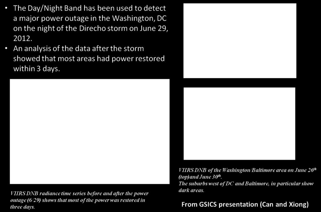
18 DNB: Power Outage Monitoring 18
19 Way Forward Overall Performance Meets Sensor Design Requirements Comparison of SDR operational F-factors with VCST F-factors (no corrections) Nearly completed (current agreement to within 0.5%) Comparison of SDR new operational F-factors with VCST F-factors (both applied with modulated RSR and H-factors) Modulated solar spectra (due to SD spectrally dependent degradation) coupled with detector OOB responses Characterization of all identified factors that could contribute to the current SD and lunar cal difference Use of modulated RSR in ROLO model (a series modulated RSR corresponding to the time of lunar observations sent to USGS) Effect due to SD attenuation screen transmission and BRF (uncertainties) Calibration inter-comparison of S-NPP VIIRS and Aqua MODIS Preliminary progress made Improvements needed with re-processed VIIRS SDR and use of Aqua MODIS C6 L1B 19
20 Acknowledgements VIIRS Characterization Support Team (VCST) MODIS Characterization Support Team (MCST) S-NPP/JPSS VIIRS SDR Team NOAA, Aerospace Corp, NASA VCST, UW, MIT/LL, RNT, and NGC 20
MODIS and VIIRS Reflective Solar Bands Calibration, Performance, and Inter-comparison
 EOS MODIS and VIIRS Reflective Solar Bands Calibration, Performance, and Inter-comparison Jack Xiong 1, Aisheng Wu 1, and Changyong Cao 2 1. NASA/GSFC; 2. NOAA/STAR Other Contributors: NASA MCST and VCST
Status of S-NPP VIIRS Solar and Lunar Calibration
 Status of S-NPP VIIRS Solar and Lunar Calibration X. Xiong 1, N. Lei 2, J. Fulbright 2, and Z. Wang 2 1 NASA Goddard Space Flight Center, Greenbelt, MD 20771, USA 2 Science Systems and Applications Inc.,
MODIS On-orbit Calibration Methodologies
 MODIS On-orbit Calibration Methodologies Jack Xiong and Bill Barnes NASA/GSFC, Greenbelt, MD 20771, USA University of Maryland, Baltimore County, Baltimore MD, 21250, USA (Support provided by entire MCST
MODIS and VIIRS Reflective Solar Calibration Update
 MODIS and VIIRS Reflective Solar Calibration Update X. Xiong 1, C. Cao 2, A. Angal 3, S. Blonski 4, N. Lei 3, W. Wang 4, Z. Wang 3, and A. Wu 3 1 NASA GSFC, MD 20771, USA; 2 NOAA NESDIS, MD 20740, USA
Update of Terra and Aqua MODIS and S-NPP VIIRS On-orbit Calibration
 Update of Terra and Aqua MODIS and S-NPP VIIRS On-orbit Calibration X. Xiong 1, C. Cao 2, A. Angal 3, K. Chiang 3, N. Lei 3, G. Lin 3, Z. Wang 3, and A Wu 3 1 NASA GSFC, MD 20771, USA; 2 NOAA NESDIS, MD
VIIRS SDR Cal/Val: S-NPP Update and JPSS-1 Preparations
 VIIRS SDR Cal/Val: S-NPP Update and JPSS-1 Preparations VIIRS SDR Cal/Val Posters: Xi Shao Zhuo Wang Slawomir Blonski ESSIC/CICS, University of Maryland, College Park NOAA/NESDIS/STAR Affiliate Spectral
MODIS Reflective Solar Bands Calibration Algorithm and On-orbit Performance
 MODIS Reflective Solar Bands Calibration Algorithm and On-orbit Performance X. (Jack) Xiong* a, J. Sun a, J. Esposito a, B. Guenther b, and W. Barnes c a Science Systems and Applications, Inc., 10210 Greenbelt
Traceability to the GIRO and ROLO
 EOS Traceability to the GIRO and ROLO Jack Xiong (NASA) In collaboration with Tom Stone (USGS) Sébastien Wagner, Tim Hewison (EUMETSAT) Sophie Lachérade, Bertrand Fougnie (CNES) GSICS Lunar Calibration
Inflight Radiometric Calibration: NASA Experience
 EOS Inflight Radiometric Calibration: NASA Experience Jack Xiong and Brian Markham Sciences and Exploration Directorate, NASA Goddard Space Flight Center Contributions: MODIS, VIIRS, and OLI Instrument
Suomi NPP VIIRS SDR postlaunch cal/val - Overview of progress and challenges
 Suomi NPP VIIRS SDR postlaunch cal/val - Overview of progress and challenges Changyong Cao 1, Jack Xiong 2, Fuzhong Weng 1, Bruce Guenther 1, and Jim Butler 2 1 NOAA, 2 NASA August 30, 2012 Sample VIIRS
Tracking On-orbit Radiometric Accuracy and Stability of Suomi NPP VIIRS using Extended Low Latitude SNOs
 Tracking On-orbit Radiometric Accuracy and Stability of Suomi NPP VIIRS using Extended Low Latitude SNOs Sirish Uprety a Changyong Cao b Slawomir Blonski c Xi Shao c Frank Padula d a CIRA, Colorado State
NOAA Cal/Val Progress Update
 NOAA Cal/Val Progress Update Xi Shao 1,2 and Changyong Cao 2 1. University of Maryland 2. NOAA/NESDIS/STAR With contributions from NOAA/NESDIS/STAR Scientists Presented at the WGCV-36, Shanghai, China,
Recent Update on MODIS C6 and VIIRS Deep Blue Aerosol Products
 Recent Update on MODIS C6 and VIIRS Deep Blue Aerosol Products N. Christina Hsu, Photo taken from Space Shuttle: Fierce dust front over Libya Corey Bettenhausen, Andrew M. Sayer, and Rick Hansell Laboratory
Joint Polar Satellite System. 3 rd Post-EPS User Consultation Workshop Mike Haas
 3 rd Post-EPS User Consultation Workshop Mike Haas Overview Introduction - Policy Drivers - Management System Description - Space Segment - Ground Segment Partnerships Status Benefits 2 Introduction (Policy
624 SNPP VIIRS Solar Diffuser BRDF Degradation Trend Changes in Early Evan Haas* and Frank De Luccia The Aerospace Corporation, El Segundo CA
 624 SNPP VIIRS Solar Diffuser BRDF Degradation Trend Changes in Early 2014 1. INTRODUCTION Evan Haas* and Frank De Luccia The Aerospace Corporation, El Segundo CA The Visible Infrared Imaging Radiometer
PUBLICATIONS. Journal of Geophysical Research: Atmospheres. VIIRS on-orbit calibration methodology and performance
 PUBLICATIONS RESEARCH ARTICLE Special Section: Suomi NPP Calibration and Validation Scientific Results Key Points: VIIRS on-orbit calibration methodology VIIRS onboard calibrators and sensor operation
McIDAS support of Suomi-NPP /JPSS and GOES-R L2
 McIDAS support of Suomi-NPP /JPSS and GOES-R L2 William Straka III 1 Tommy Jasmin 1, Bob Carp 1 1 Cooperative Institute for Meteorological Satellite Studies, Space Science and Engineering Center, University
Suomi National Polar orbiting Partnership (NPP) VIIRS data product assessment
 VIIRS data product assessment") Suomi National Polar orbiting Partnership (NPP) VIIRS data product assessment K. Turpie Ocean Color Science PI VIIRS Ocean Science Team (VOST) Ocean Color Research Team Meeting 23 April 2012 Seattle, Washington
Suomi National Polar orbiting Partnership (NPP) VIIRS data product assessment K. Turpie Ocean Color Science PI VIIRS Ocean Science Team (VOST) Ocean Color Research Team Meeting 23 April 2012 Seattle, Washington
Development and Implementation of an Electronic Crosstalk Correction for Bands in Terra MODIS Collection 6
 remote sensing Article Development and Implementation of an Electronic Crosstalk Correction for Bands 27 3 in Terra MODIS Collection 6 Truman Wilson 1, *, Aisheng Wu 1, Ashish Shrestha 1, Xu Geng 1, Zhipeng
*C. Pan 1, F. Weng 2, T. Beck 2 and S. Ding 3
 S NPP Ozone Mapping Profiler Suite Nadir Instrument Radiometric Calibration *C. Pan 1, F. Weng 2, T. Beck 2 and S. Ding 3 Curtsey of Ball Aerospace and Technologies Corp. * 1 ESSIC, University of Maryland,
MODIS on-orbit spatial characterization results using ground measurements
 MODIS on-orbit spatial characterization results using ground measurements Yong Xie 1, Xiaoxiong Xiong 2, John J Qu 1,2, Nianzeng Che 3, Lingli Wang 1 1 Center for Earth Observing and Space Research (CEOSR)
The Ozone Mapping and Profiler Suite (OMPS): From SNPP to JPSS-1
: From SNPP to JPSS-1") The Ozone Mapping and Profiler Suite (OMPS): From SNPP to JPSS-1 *C. Pan 1 and F. Weng 2 Curtsey of BATC Aerosol Index * 1 ESSIC, University of Maryland, College Park, MD 20740; 2 NOAA NESDIS/STAR, College
The Ozone Mapping and Profiler Suite (OMPS): From SNPP to JPSS-1 *C. Pan 1 and F. Weng 2 Curtsey of BATC Aerosol Index * 1 ESSIC, University of Maryland, College Park, MD 20740; 2 NOAA NESDIS/STAR, College
The EarthCARE mission: An active view on aerosols, clouds and radiation
 The EarthCARE mission: An active view on aerosols, clouds and radiation T. Wehr, T. Fehr, P. Ingmann, J. v. Bismarck ESRIN, Frascati, Italy 20/10/2015 EARTH Clouds, Aerosols and Radiation Explorer EarthCARE
Interpretation of Polar-orbiting Satellite Observations. Atmospheric Instrumentation
 Interpretation of Polar-orbiting Satellite Observations Outline Polar-Orbiting Observations: Review of Polar-Orbiting Satellite Systems Overview of Currently Active Satellites / Sensors Overview of Sensor
Cross-calibration of Geostationary Satellite Visible-channel Imagers Using the Moon as a Common Reference
 Cross-calibration of Geostationary Satellite Visible-channel Imagers Using the Moon as a Common Reference Thomas C. Stone U.S. Geological Survey, Flagstaff AZ, USA 27 30 August, 2012 Motivation The archives
Adjusting Aqua MODIS TEB nonlinear calibration coefficients using iterative solution
 Adjusting Aqua MODIS TEB nonlinear calibration coefficients using iterative solution Aisheng Wu a, Zhipeng (Ben) Wang a, Yonghong Li a, Sriharsha Madhavan b, Brian N. Wenny a, Na Chen a, and Xiaoxiong
Land Surface Temperature Measurements From the Split Window Channels of the NOAA 7 Advanced Very High Resolution Radiometer John C.
 Land Surface Temperature Measurements From the Split Window Channels of the NOAA 7 Advanced Very High Resolution Radiometer John C. Price Published in the Journal of Geophysical Research, 1984 Presented
Orbital Variation of Blackbody. VIIRS Thermal Emissive Band
 Orbital Variation of Blackbody Thermistor Temperature for S NPP VIIRS Thermal Emissive Band Calibration i Xi Shao 1, Changyong Cao 2, Slawomir Blonski 1, Quanhua (Mark) Liu 1 1. University of Maryland,
JPSS-1 VIIRS Radiometric Characterization and Calibration Based on Pre-Launch Testing
 remote sensing Article JPSS-1 VIIRS Radiometric Characterization Calibration Based on Pre-Launch Testing Hassan Oudrari 1, *, Jeff McIntire 1, Xiaoxiong Xiong 2, James Butler 2, Qiang Ji 1, Thomas Schwarting
Ocean Colour: Calibration Approach. CEOS WGCV-39, May The International Ocean Colour Coordinating Group
 Ocean Colour: Calibration Approach CEOS WGCV-39, May 2015 The International Ocean Colour Coordinating Group Ocean Colour requires special calibration considerations Percentage of ocean signal in the total
NASA's Plankton, Aerosol, Cloud, ocean Ecosystem (PACE) mission update
 mission update") NASA's Plankton, Aerosol, Cloud, ocean Ecosystem (PACE) mission update Antonio Mannino1, Jeremy Werdell1, Brian Cairns2 NASA GSFC1 and GISS2 Acknowledgments: PACE Team https://pace.gsfc.nasa.gov 1 Outline
NASA's Plankton, Aerosol, Cloud, ocean Ecosystem (PACE) mission update Antonio Mannino1, Jeremy Werdell1, Brian Cairns2 NASA GSFC1 and GISS2 Acknowledgments: PACE Team https://pace.gsfc.nasa.gov 1 Outline
Minutes of the First Meeting. of the IOCCG Working Group. L1 Requirements for Ocean-Colour Remote Sensing. April 20-21, 2010
 Minutes of the First Meeting of the IOCCG Working Group L1 Requirements for Ocean-Colour Remote Sensing April 20-21, 2010 Bethesda, Maryland (Washington, D.C.), USA Participants: - Charles R. McClain (chair,
Suomi NPP VIIRS sensor data record verification, validation, and long-term performance monitoring
 JOURNAL OF GEOPHYSICAL RESEARCH: ATMOSPHERES, VOL. 118, 11,664 11,678, doi:10.1002/2013jd020418, 2013 Suomi NPP VIIRS sensor data record verification, validation, and long-term performance monitoring Changyong
Moderate Resolution Imaging Spectroradiometer (MODIS) Products and Potential Applications For Environmental and Climatic Monitoring in China
 Products and Potential Applications For Environmental and Climatic Monitoring in China") Moderate Resolution Imaging Spectroradiometer (MODIS) Products and Potential Applications For Environmental and Climatic Monitoring in China Jianhe (John) Qu Center for Earth Observing and Space Research
Moderate Resolution Imaging Spectroradiometer (MODIS) Products and Potential Applications For Environmental and Climatic Monitoring in China Jianhe (John) Qu Center for Earth Observing and Space Research
Estimation of ocean contribution at the MODIS near-infrared wavelengths along the east coast of the U.S.: Two case studies
 GEOPHYSICAL RESEARCH LETTERS, VOL. 32, L13606, doi:10.1029/2005gl022917, 2005 Estimation of ocean contribution at the MODIS near-infrared wavelengths along the east coast of the U.S.: Two case studies
Monitoring the NOAA Operational VIIRS RSB and DNB Calibration Stability Using Monthly and Semi-Monthly Deep Convective Clouds Time Series
 remote sensing Article Monitoring the NOAA Operational VIIRS RSB and DNB Calibration Stability Using Monthly and Semi-Monthly Deep Convective Clouds Time Series Wenhui Wang 1, * and Changyong Cao 2 Received:
GMES: calibration of remote sensing datasets
 GMES: calibration of remote sensing datasets Jeremy Morley Dept. Geomatic Engineering jmorley@ge.ucl.ac.uk December 2006 Outline Role of calibration & validation in remote sensing Types of calibration
First Lunar Results from the Moon & Earth Radiation Budget Experiment (MERBE)
") First Lunar Results from the Moon & Earth Radiation Budget Experiment (MERBE) Grant Matthews Accelerating certainty in climate change prediction GSICS Lunar cal meeting 6 th Dec 2016 Overview "The single
First Lunar Results from the Moon & Earth Radiation Budget Experiment (MERBE) Grant Matthews Accelerating certainty in climate change prediction GSICS Lunar cal meeting 6 th Dec 2016 Overview "The single
GOSAT mission schedule
 GOSAT mission schedule 29 21 12 1 2 3 4 6 7 8 9 1 11 12 1 2 214 1 2 3 ~ Jan. 23 Launch Initial Checkout Initial function check Initial Cal. and Val. Mission life Normal observation operation Extra Operati
Atmospheric Lidar The Atmospheric Lidar (ATLID) is a high-spectral resolution lidar and will be the first of its type to be flown in space.
 is a high-spectral resolution lidar and will be the first of its type to be flown in space.") www.esa.int EarthCARE mission instruments ESA s EarthCARE satellite payload comprises four instruments: the Atmospheric Lidar, the Cloud Profiling Radar, the Multi-Spectral Imager and the Broad-Band Radiometer.
www.esa.int EarthCARE mission instruments ESA s EarthCARE satellite payload comprises four instruments: the Atmospheric Lidar, the Cloud Profiling Radar, the Multi-Spectral Imager and the Broad-Band Radiometer.
Sentinel-3 Sea and Land Surface Temperature Radiometer (SLSTR) Mireya Etxaluze (STFC RAL Space)
 Mireya Etxaluze (STFC RAL Space)") Sentinel-3 Sea and Land Surface Temperature Radiometer (SLSTR) Mireya Etxaluze (STFC RAL Space) RAL Space Radiometry Group Dave Smith Mireya Etxaluze, Ed Polehampton, Caroline Cox, Tim Nightingale, Dan
Sentinel-3 Sea and Land Surface Temperature Radiometer (SLSTR) Mireya Etxaluze (STFC RAL Space) RAL Space Radiometry Group Dave Smith Mireya Etxaluze, Ed Polehampton, Caroline Cox, Tim Nightingale, Dan
Extending the Deep Blue aerosol record from SeaWiFS and MODIS to NPP-VIIRS
 Extending the Deep Blue aerosol record from SeaWiFS and MODIS to NPP-VIIRS Andrew M. Sayer, N. Christina Hsu (PI), Corey Bettenhausen, Jaehwa Lee Climate & Radiation Laboratory, NASA Goddard Space Flight
Radiometric Calibration Stability and Inter-calibration of Solar-band Instruments in Orbit Using the Moon
 Radiometric Calibration Stability and Inter-calibration of Solar-band Instruments in Orbit Using the Moon Thomas C. Stone a a U.S. Geological Survey, 2255 N. Gemini Drive, Flagstaff, AZ, 86001 ABSTRACT
Sumi-NPP OMPS Calibration and Characterization from Early Orbit Images
 Sumi-NPP OMPS Calibration and Characterization from Early Orbit Images *C. Pan 1, F. Weng 2, X. Wu 2, L. Flynn 2, G. Jaross 3 and S. Janz 4 * 1 ESSIC, University of Maryland, College Park, MD 20740 2 NOAA
GCOM-C SGLI calibration and characterization. Hiroshi Murakami JAXA/EORC Satellite instrument pre- and post-launch calibration
 GCOM-C SGLI calibration and characterization Hiroshi Murakami JAXA/EORC Satellite instrument pre- and post-launch calibration 1 1. SGLI sensor system and onboard calibration system Target: Improvement
GCOM-C/SGLI and its Lunar Calibration
 GCOM-C/SGLI and its Lunar Calibration Lunar Calibration Workshop December 1-4, 2014 JAXA/GCOM Proj. Yoshihiko Okamura (okamura.yoshihiko@jaxa.jp) 1. Overview of GCOM-C satellite and SGLI (1) Global Change
JPSS GEONETCAST REQUIREMENTS DISCUSSION
 Joint Polar Satellite System (JPSS) JPSS GEONETCAST REQUIREMENTS DISCUSSION Mitch Goldberg Program Scientist Joint Polar Satellite System National Environmental Satellite, Data, and Information Service
AIRS Level 1b. Tom Pagano AIRS Project Project Manager. Hartmut Aumann AIRS Project Scientist
 AIRS Level 1b Tom Pagano AIRS Project Project Manager Hartmut Aumann AIRS Project Scientist Jet Propulsion Laboratory California Institute of Technology and Ken Overoye AIRS Calibration System Engineer
The EarthCARE mission: An active view on aerosols, clouds and radiation
 The EarthCARE mission: An active view on aerosols, clouds and radiation T. Wehr, P. Ingmann, T. Fehr Heraklion, Crete, Greece 08/06/2015 EarthCARE is ESA s sixths Earth Explorer Mission and will be implemented
Introducing VIIRS Aerosol Products
 1 Introducing VIIRS Aerosol Products Shobha Kondragunta NOAA/NESDIS Center for Satellite Applications and Research VIIRS Aerosol Cal/Val Team 2 Name Organization Major Task Kurt F. Brueske IIS/Raytheon
Instrumentation planned for MetOp-SG
 Instrumentation planned for MetOp-SG Bill Bell Satellite Radiance Assimilation Group Met Office Crown copyright Met Office Outline Background - the MetOp-SG programme The MetOp-SG instruments Summary Acknowledgements:
Solar Cycle 24 Variability Observed by Aura OMI Matthew DeLand and Sergey Marchenko Science Systems and Applications, Inc. (SSAI)
") Solar Cycle 24 Variability Observed by Aura OMI Matthew DeLand and Sergey Marchenko Science Systems and Applications, Inc. (SSAI) 2014 SORCE Science Meeting Cocoa Beach, FL 28-31 January 2014 Solar Measurements
Solar Cycle 24 Variability Observed by Aura OMI Matthew DeLand and Sergey Marchenko Science Systems and Applications, Inc. (SSAI) 2014 SORCE Science Meeting Cocoa Beach, FL 28-31 January 2014 Solar Measurements
Lectures 7 and 8: 14, 16 Oct Sea Surface Temperature
 Lectures 7 and 8: 14, 16 Oct 2008 Sea Surface Temperature References: Martin, S., 2004, An Introduction to Ocean Remote Sensing, Cambridge University Press, 454 pp. Chapter 7. Robinson, I. S., 2004, Measuring
NESDIS Polar (Region) Products and Plans. Jeff Key NOAA/NESDIS Madison, Wisconsin USA
 Products and Plans. Jeff Key NOAA/NESDIS Madison, Wisconsin USA") NESDIS Polar (Region) Products and Plans Jeff Key NOAA/NESDIS Madison, Wisconsin USA WMO Polar Space Task Group, 2 nd meeting, Geneva, 12 14 June 2012 Relevant Missions and Products GOES R ABI Fractional
NESDIS Polar (Region) Products and Plans Jeff Key NOAA/NESDIS Madison, Wisconsin USA WMO Polar Space Task Group, 2 nd meeting, Geneva, 12 14 June 2012 Relevant Missions and Products GOES R ABI Fractional
HICO Calibration and Atmospheric Correction
 HICO Calibration and Atmospheric Correction Curtiss O. Davis College of Earth Ocean and Atmospheric Sciences Oregon State University, Corvallis, OR, USA 97331 cdavis@coas.oregonstate.edu Oregon State Introduction
Outcome of the GSICS/CEOS-IVOS Lunar Calibration Workshop
 Outcome of the GSICS/CEOS-IVOS Lunar Calibration Workshop S. Wagner a, T. Hewison a, T. Stone b, S. Lachérade c, B. Fougnie c, X. Xiong d With the support of M. Takahashi JMA (1-year visiting scientist
Pre-Launch Radiometric Characterization of JPSS-1 VIIRS Thermal Emissive Bands
 Article Pre-Launch Radiometric Characterization of JPSS-1 VIIRS Thermal Emissive Bands Jeff McIntire 1, *, David Moyer 2, Hassan Oudrari 1 and Xiaoxiong Xiong 3 Received: 28 October 2015; Accepted: 25
Hyperspectral Atmospheric Correction
 Hyperspectral Atmospheric Correction Bo-Cai Gao June 2015 Remote Sensing Division Naval Research Laboratory, Washington, DC USA BACKGROUND The concept of imaging spectroscopy, or hyperspectral imaging,
Landsat-8 Operational Land Imager (OLI) Initial On-Orbit Performance
 Initial On-Orbit Performance") Landsat-8 Operational Land Imager (OLI) Initial On-Orbit Performance Geir Kvaran, Ed Knight, Khurrum Ansari, Kenton Lee, Brent Canova, Brian Donley Ball Aerospace & Technologies Corp. Hugh Kieffer Celestial
Landsat-8 Operational Land Imager (OLI) Initial On-Orbit Performance Geir Kvaran, Ed Knight, Khurrum Ansari, Kenton Lee, Brent Canova, Brian Donley Ball Aerospace & Technologies Corp. Hugh Kieffer Celestial
VIIRS Radiometric Calibration for Reflective Solar Bands: Antarctic Dome C Site and Simultaneous Nadir Overpass Observations
 VIIRS Radiometric Calibration for Reflective Solar Bands: Antarctic Dome C Site and Simultaneous Nadir Overpass Observations Slawomir Blonski, * Changyong Cao, Sirish Uprety, ** and Xi Shao * NOAA NESDIS
Operational Uses of Bands on the GOES-R Advanced Baseline Imager (ABI) Presented by: Kaba Bah
 Presented by: Kaba Bah") Operational Uses of Bands on the GOES-R Advanced Baseline Imager (ABI) Presented by: Kaba Bah Topics: Introduction to GOES-R & ABI ABI individual bands Use of band differences ABI derived products Conclusions
Operational Uses of Bands on the GOES-R Advanced Baseline Imager (ABI) Presented by: Kaba Bah Topics: Introduction to GOES-R & ABI ABI individual bands Use of band differences ABI derived products Conclusions
The O 2 A-band Spectrometer on the NASA Orbiting Carbon Observatory-2 (OCO-2)
") Workshop on Remote sensing in the O 2 A-band The O 2 A-band Spectrometer on the NASA Orbiting Carbon Observatory-2 (OCO-2) David Crisp for the OCO-2 Science Team Jet Propulsion Laboratory, California Institute
Workshop on Remote sensing in the O 2 A-band The O 2 A-band Spectrometer on the NASA Orbiting Carbon Observatory-2 (OCO-2) David Crisp for the OCO-2 Science Team Jet Propulsion Laboratory, California Institute
Pre-Launch Characterization and In-orbit Calibration of GCOM-C/SGLI
 Pre-Launch Characterization and In-orbit Calibration of GCOM-C/SGLI IGARSS 2018 July 26, 2018 Japan Aerospace Exploration Agency Yoshihiko Okamura T. Hashiguchi, T. Urabe, K. Tanaka (JAXA) J Yoshida, T
Operational systems for SST products. Prof. Chris Merchant University of Reading UK
 Operational systems for SST products Prof. Chris Merchant University of Reading UK Classic Images from ATSR The Gulf Stream ATSR-2 Image, ƛ = 3.7µm Review the steps to get SST using a physical retrieval
FY-2 On-orbit Operational Calibration Approach (CIBLE) and its Benefit to FY-2D/E AMV Products
 and its Benefit to FY-2D/E AMV Products") 12 th International Winds Workshop (IWW12) Calibration of Inner Blackbody corrected by Lunar Emission (CIBLE) FY-2 On-orbit Operational Calibration Approach (CIBLE) and its Benefit to FY-2D/E AMV Products
12 th International Winds Workshop (IWW12) Calibration of Inner Blackbody corrected by Lunar Emission (CIBLE) FY-2 On-orbit Operational Calibration Approach (CIBLE) and its Benefit to FY-2D/E AMV Products
Characterization of the VIIRS Blackbody Emittance
 Characterization of the VIIRS Blackbody Emittance Jeremy Kloepfer, Chris Taylor, and Vijay Murgai jeremiah_kloepfer@raytheon.com Conference on Characterization and Radiometric Calibration for Remote Sensing,
Status of Land Surface Temperature Product Development for JPSS Mission
 Status of Land Surface Temperature Product Development for JPSS Mission Yuling Liu 1,2, Yunyue Yu 2, Peng Yu 1,2 and Heshun Wang 1,2 1 ESSIC at University of Maryland, College Park, MD USA 2 Center for
GSICS UV Sub-Group Activities
 GSICS UV Sub-Group Activities Rosemary Munro with contributions from NOAA, NASA and GRWG UV Subgroup Participants, in particular L. Flynn 1 CEOS Atmospheric Composition Virtual Constellation Meeting (AC-VC)
The Sentinel-4 Mission and its Atmospheric Composition Products
 This image cannot currently be displayed. The Sentinel-4 Mission and its Atmospheric Composition Products Ben Veihelmann, Yasjka Meijer, Jörg Langen, Paul Ingmann, Rob Koopman, Norrie Wright, Grégory Bazalgette
Thermal And Near infrared Sensor for carbon Observation (TANSO) On board the Greenhouse gases Observing SATellite (GOSAT) Research Announcement
 On board the Greenhouse gases Observing SATellite (GOSAT) Research Announcement") Thermal And Near infrared Sensor for carbon Observation (TANSO) On board the Greenhouse gases Observing SATellite (GOSAT) Research Announcement Appendix A Outlines of GOSAT and TANSO Sensor GOSAT (Greenhouse
Thermal And Near infrared Sensor for carbon Observation (TANSO) On board the Greenhouse gases Observing SATellite (GOSAT) Research Announcement Appendix A Outlines of GOSAT and TANSO Sensor GOSAT (Greenhouse
EUMETSAT STATUS AND PLANS
 1 EUM/TSS/VWG/15/826793 07/10/2015 EUMETSAT STATUS AND PLANS François Montagner, Marine Applications Manager, EUMETSAT WMO Polar Space Task Group 5 5-7 October 2015, DLR, Oberpfaffenhofen PSTG Strategic
JPSS. Suomi NPP* satellite, JPSS-1 satellite, and JPSS-2 satellite Four primary instruments (ATMS, CrIS, VIIRS, OMPS)
") Operational and Research Applications from the Joint Polar Satellite System (JPSS) Nove be 200 2014 0 November AOMSUC-5 Mitch Goldberg, JPSS Program Scientist Presented by: Lihang Zhou, JPSS STAR (JSTAR)
Operational and Research Applications from the Joint Polar Satellite System (JPSS) Nove be 200 2014 0 November AOMSUC-5 Mitch Goldberg, JPSS Program Scientist Presented by: Lihang Zhou, JPSS STAR (JSTAR)
Some NOAA Products that Address PSTG Satellite Observing Requirements. Jeff Key NOAA/NESDIS Madison, Wisconsin USA
 Some NOAA Products that Address PSTG Satellite Observing Requirements Jeff Key NOAA/NESDIS Madison, Wisconsin USA WMO Polar Space Task Group, 4 th meeting, Greenbelt, 30 September 2014 Relevant Missions
EPS-SG Candidate Observation Missions
 EPS-SG Candidate Observation Missions 3 rd Post-EPS User Consultation Workshop Peter Schlüssel Slide: 1 EPS-SG benefits to activities of NMSs Main Payload High-Resolution Infrared Sounding Microwave Sounding
Chapter 4 Nadir looking UV measurement. Part-I: Theory and algorithm
 Chapter 4 Nadir looking UV measurement. Part-I: Theory and algorithm -Aerosol and tropospheric ozone retrieval method using continuous UV spectra- Atmospheric composition measurements from satellites are
Thermal And Near infrared Sensor for carbon Observation (TANSO) onboard the Greenhouse gases Observing SATellite (GOSAT) Research Announcement
 onboard the Greenhouse gases Observing SATellite (GOSAT) Research Announcement") Thermal And Near infrared Sensor for carbon Observation (TANSO) onboard the Greenhouse gases Observing SATellite (GOSAT) Research Announcement Appendix C Operation Policies of GOSAT and Basic Observation
Thermal And Near infrared Sensor for carbon Observation (TANSO) onboard the Greenhouse gases Observing SATellite (GOSAT) Research Announcement Appendix C Operation Policies of GOSAT and Basic Observation
Accuracy and Precision Requirements for Climate-Level Data Sets
 Accuracy and Precision Requirements for Climate-Level Data Sets K. Thome NASA/GSFC Libya-4 Workshop Paris, France October 4-5, 2012 Accuracy requirements Commercial imagers Precision and SNR drive calibration
Comparison of NASA AIRS and MODIS Land Surface Temperature and Infrared Emissivity Measurements from the EOS AQUA platform
 Comparison of NASA AIRS and MODIS Land Surface Temperature and Infrared Emissivity Measurements from the EOS AQUA platform Robert Knuteson, Steve Ackerman, Hank Revercomb, Dave Tobin University of Wisconsin-Madison
Once a specific data set is selected, NEO will list related data sets in the panel titled Matching Datasets, which is to the right of the image.
 NASA Earth Observations (NEO): A Brief Introduction NEO is a data visualization tool that allows users to explore a wealth of environmental data collected by NASA satellites. The satellites use an array
Overview of The CALIPSO Mission
 Overview of The CALIPSO Mission Dave Winker NASA-LaRC LaRC,, PI Jacques Pelon IPSL/CNRS, co-pi Research Themes Improved understanding of the Earth s climate system is a primary goal of the Scientific Community
VIIRS narrowband to broadband land surface albedo conversion: formula and validation
 International Journal of Remote Sensing Vol. 26, No. 5, 10 March 2005, 1019 1025 VIIRS narrowband to broadband land surface albedo conversion: formula and validation S. LIANG*{, Y. YU{ and T. P. DEFELICE{
CLAVR-x is the Clouds from AVHRR Extended Processing System. Responsible for AVHRR cloud products and other products at various times.
 CLAVR-x in CSPP Andrew Heidinger, NOAA/NESDIS/STAR, Madison WI Nick Bearson, SSEC, Madison, WI Denis Botambekov, CIMSS, Madison, WI Andi Walther, CIMSS, Madison, WI William Straka III, CIMSS, Madison,
Calibration of Ocean Colour Sensors
 Dr. A. Neumann German Aerospace Centre DLR Remote Sensing Technology Institute Marine Remote Sensing What is Calibration, why do we need it? Sensor Components Definition of Terms Calibration Standards
Using HARP measurements for deriving cloud, aerosol, and surface properties for TORERO. K. Sebastian Schmidt and Bruce Kindel 31 Oct 2011
 Using HARP measurements for deriving cloud, aerosol, and surface properties for TORERO K. Sebastian Schmidt and Bruce Kindel 31 Oct 2011 Goals HARP irradiances (Sam Hall) [yr 1] AMAX-DOAS AOT [yr 1] HSRL
(A)ATSR and SLSTR VIS/SWIR Channels Calibration
ATSR and SLSTR VIS/SWIR Channels Calibration") (A)ATSR and SLSTR VIS/SWIR Channels Calibration Dave Smith & Mireya Etxaluze 2017 RAL Space 1 ATSR Series 1991-2000 ATSR-1 1995-2008 ATSR-2 2002-2012- AATSR 2 SLSTR Series 2016 Sentinel 3A 2018 Sentinel
(A)ATSR and SLSTR VIS/SWIR Channels Calibration Dave Smith & Mireya Etxaluze 2017 RAL Space 1 ATSR Series 1991-2000 ATSR-1 1995-2008 ATSR-2 2002-2012- AATSR 2 SLSTR Series 2016 Sentinel 3A 2018 Sentinel
The Moon & Earth Radiation Budget Experiment (MERBE)
") The Moon & Earth Radiation Budget Experiment (MERBE) Grant Matthews Animation credit Wikipedia Accelerating certainty in climate change prediction 97th AMS Meeting 23 rd Jan 2017 Seattle WA Overview "The
The Moon & Earth Radiation Budget Experiment (MERBE) Grant Matthews Animation credit Wikipedia Accelerating certainty in climate change prediction 97th AMS Meeting 23 rd Jan 2017 Seattle WA Overview "The
Vicarious calibration of S-NPP VIIRS reflective solar M-bands against MODIS Aqua over dark water scenes
 Atmos. Meas. Tech. Discuss., doi:.194/amt-16-238, 16 Vicarious calibration of S-NPP VIIRS reflective solar M-bands against MODIS Aqua over dark water scenes A. M. Sayer 1,2, N. C. Hsu 1, C. Bettenhausen
Status of CNES Cal/Val Activities
 GSICS Executive Panel Meeting 16-17th May 2014, Guangzhou, China Status of CNES Cal/Val Activities Patrice Henry CNES 1 Summary Overview of CNES Cal/Val Activities Summary Re-Calibration Activities POLDER(s)/PARASOL
Aerosol Retrieved from MODIS: Algorithm, Products, Validation and the Future
 Aerosol Retrieved from MODIS: Algorithm, Products, Validation and the Future Presented by: Rob Levy Re-presenting NASA-GSFC s MODIS aerosol team: Y. Kaufman, L. Remer, A. Chu,, C. Ichoku,, R. Kleidman,,
GOSAT update. June Prepared by JAXA EORC Presented by David Crisp
 CEOS AC-VC GOSAT update June Prepared by JAXA EORC Presented by David Crisp GOSAT & GOSAT-2 Organization ORGANIZATION GOSAT is the joint project of JAXA, MOE (Ministry of the Environment) and NIES (National
Vicarious calibration of GLI by global datasets. Calibration 5th Group Hiroshi Murakami (JAXA EORC)
") Vicarious calibration of GLI by global datasets Calibration 5th Group Hiroshi Murakami (JAXA EORC) ADEOS-2 PI workshop March 2004 1 0. Contents 1. Background 2. Operation flow 3. Results 4. Temporal change
Vicarious calibration of GLI by global datasets Calibration 5th Group Hiroshi Murakami (JAXA EORC) ADEOS-2 PI workshop March 2004 1 0. Contents 1. Background 2. Operation flow 3. Results 4. Temporal change
A Comparative Study and Intercalibration Between OSMI and SeaWiFS
 A Comparative Study and Intercalibration Between OSMI and SeaWiFS KOMPSAT-1 Bryan A. Franz NASA SIMBIOS Project Yongseung Kim Korea Aerospace Research Institute ORBVIEW-2 Abstract Since 1996, following
Impacts of Atmospheric Corrections on Algal Bloom Detection Techniques
 1 Impacts of Atmospheric Corrections on Algal Bloom Detection Techniques Ruhul Amin, Alex Gilerson, Jing Zhou, Barry Gross, Fred Moshary and Sam Ahmed Optical Remote Sensing Laboratory, the City College
GOES R Calibration Working Group. Progress Update
 GOES-R Calibration Working Group Progress Update Changyong Cao With contributions from B. Iacovazzi, A. Pearlman, D. Pogorzala, X. Shao, Raju Datla, and S. Uprety NOAA/NESDIS/STAR GOES R Calibration Working
NIR Solar Reference Spectrum Algorithm for the Orbiting Carbon Observatory (OCO)
") NIR Solar Reference Spectrum Algorithm for the Orbiting Carbon Observatory (OCO) Hartmut Bösch and Geoffrey Toon Jet Propulsion Laboratory, California Institute of Technology OCO Mission Global, space-based
NIR Solar Reference Spectrum Algorithm for the Orbiting Carbon Observatory (OCO) Hartmut Bösch and Geoffrey Toon Jet Propulsion Laboratory, California Institute of Technology OCO Mission Global, space-based
Angelika Dehn Rob Koopman 10 Years GOME on ERS-2 Workshop
 Angelika Dehn (ADehn@serco.it), Rob Koopman (Rob.Koopman@esa.int), Overview I. ERS-2 Mission History 1. Mission Plan Highlights 2. GOME Special Operations II. GOME-1 Engineering Performance 1. Routine
Influence of Clouds and Aerosols on the Earth s Radiation Budget Using Clouds and the Earth s Radiant Energy System (CERES) Measurements
 Measurements") Influence of Clouds and Aerosols on the Earth s Radiation Budget Using Clouds and the Earth s Radiant Energy System (CERES) Measurements Norman G. Loeb Hampton University/NASA Langley Research Center Bruce
Influence of Clouds and Aerosols on the Earth s Radiation Budget Using Clouds and the Earth s Radiant Energy System (CERES) Measurements Norman G. Loeb Hampton University/NASA Langley Research Center Bruce
MERIS US Workshop. Instrument Characterization Overview. Steven Delwart
 MERIS US Workshop Instrument Characterization Overview Steven Delwart Presentation Overview On-Ground Characterisation 1. Diffuser characterisation 2. Polarization sensitivity 3. Optical Transmission 4.
Space Science and Engineering Center, University of Wisconsin-Madison, Madison, Wisconsin 1. INTRODUCTION
 695 SUOMI NPP/JPSS CROSS-TRACK INFRARED SOUNDER (CRIS): CALIBRATION VALIDATION WITH THE AIRCRAFT BASED SCANNING HIGH-RESOLUTION INTERFEROMETER SOUNDER (S-HIS) Joe K. Taylor *, H.E. Revercomb, D. C. Tobin,
The Earth Climate Hyperspectral Observatory: Advances in Climate Change Detection, Attribution, and Remote Sensing
 The Earth Climate Hyperspectral Observatory: Advances in Climate Change Detection, Attribution, and Remote Sensing Peter Pilewskie, Greg Kopp, Odele Coddington, Sebastian Schmidt, Tom Sparn University