Status of CNES Cal/Val Activities
|
|
|
- Morgan McCarthy
- 6 years ago
- Views:
Transcription
1 GSICS Executive Panel Meeting 16-17th May 2014, Guangzhou, China Status of CNES Cal/Val Activities Patrice Henry CNES 1
2 Summary Overview of CNES Cal/Val Activities Summary Re-Calibration Activities POLDER(s)/PARASOL reprocessing VGT1&2 reprocessing (SPOT World Heritage) Support to MERIS Towards a lunar calibration improvement Use of Pleiades lunar acquisitions Monitoring of IASI/AIRS/CRIS inter-calibration 2
3 CNES Cal/Val activities Calibration monitoring of CNES missions in operation phase Pléiades 1A&1B, IASI A&B, Saphir & Scarab (Megha-Tropiques), IIR/Calipso Reprocessing and sustainable archiving of the past CNES missions POLDER/PARASOL Intensive recalibration program and complete reprocessing in 2014 (level 1 to 3) VGT Enhanced calibration program and VGT1&2 reprocessing in 2014/2015 SPOT(s) SPOT World Heritage project 3 Participation in the calibration of partners missions MERIS Calibration check using the various CNES tools SPOT 6&7 Calibration of the Astrium new SPOT satellites Sentinel2 Calibration and performances assessment for the in-flight commissioning phase Sentinel3 Participation in the OLCI and SLSTR in orbit calibration monitoring
4 4 Overview of PARASOL Recalibration (achieved reprocessing in progress)
 + spectral interpolation oall reflective bands - 412 to 2200nm [Henry et al., IEEE, 2013; Lachérade et al.")
![, IEEE, 2013] Rayleigh Scattering o6 main oceanic sites oselection of very non-turbid situations orayleigh contribution about 90% omarine contribution, aerosol background ovis bands - 412 to 670nm](/docs-images/74/69781385/images/5-2.jpg "[Hagolle et al., IEEE, 1999; Fougnie et al.")
5 Applying Operational Calibration Methods Desert Sites (PICS) o20 stable sites Africa/Arabia o1 sensor as ref. = cross-calibration o1 date as ref. = multitemporal ogeometrical matching (same geometry) + spectral interpolation oall reflective bands to 2200nm [Henry et al., IEEE, 2013; Lachérade et al., IEEE, 2013] Rayleigh Scattering o6 main oceanic sites oselection of very non-turbid situations orayleigh contribution about 90% omarine contribution, aerosol background ovis bands to 670nm [Hagolle et al., IEEE, 1999; Fougnie et al., OO, 2002] Clouds (DCC) oselection of white DCC brightness, high altitude, homogeneity o1 band as reference = interband ocot estimated using reference band ospectral correction assuming a CPT ovis-nir bands to 865nm Sunglint [Lafrance et al., IEEE, 2002; Fougnie et al., IEEE, 2009] o6 main oceanic sites oselection of very non-turbid situations o1 band as reference = interband osunglint estimated using reference band omarine contribution, aerosol background oall reflective bands to 2200nm [Hagolle et al., IEEE, 2004] Antarctica 5
6 Multi-Methods Synergic Approach Combining the capability of each method Rayleigh Scattering Desert sites Snow (Dome C) Clouds (DCC) Sunglint Method Absolute cal. Interband cal. Field-of-view cal. Temporal monitoring Cross-calibration Polarisation Characterization 6

 = A( to) [ 1 B (1 exp( D t))")
7 Temporal Evolution: Model Adjustement B490 = 0.16 D=0.018 B565 = 0.11 B670 = B865 = B1020 = A( t) = A( to) [ 1 B (1 exp( D t)) ] B765 =
 suggest it is not the case Rayleigh (absolute reference) confirm that for 75% of the coverage sufficient to generalize Confirmed also")
 Absolute calibration over Rayleigh 8 Black hole confirmed by Rayleigh Instrument-765 Bright banner not confirmed")
8 PARASOL in the Field of View Calibration Calibration for the in field-of-view evolution DCC calibration suppose the reference band is stable (765nm) Desert (reference = POLDER1) suggest it is not the case Rayleigh (absolute reference) confirm that for 75% of the coverage sufficient to generalize Confirmed also for most of other bands Band 490nm Calibration result versus pixel on the CCD matrix The black hole from band 765nm Interband over DCC (ref=765) Intercalibration over desert (ref=pol1) Absolute calibration over Rayleigh 8 Black hole confirmed by Rayleigh Instrument-765 Bright banner not confirmed method artefact

9 Blue and green bands Relative calibration estimation 9

10 Red and PIR bands Relative calibration estimation 10


11 Validation DES : RAY : DCC : Nov nm band Scale: [+/-20%] Average along columns Average along lines Average along columns Average along lines D E S R A Y D C C 11 L1 before L1 corrected
12 Impact on level 2 products Aerosol Optical Depth over ocean» Validation against aeronet 12
13 13 Outlines of VGT Recalibration (work in process)
14 Intensive Averaging of VGT Data 2 sets of lines (averaging raw products) PIR Band 14
15 Pixel to Pixel Relative Calibration Hanning filtering (to remove LF) PIR Band 15
16 Validation of the Estimated Coefficients PIR Band 16
 Pre flight (2002) 17 PIR (B3)")
17 Relative calibration coefficients comparison In orbit(2011) Pre flight (2002) 17 PIR (B3) BAND
18 Low Freq. Relative Calibration Evolution As seen by the on-board lamp: R lamp (t)/r lamp (2002) Blue Band 18 Detector #

19 Low Freq. Relative Calibration Evolution As seen by Rayleigh Scatering Calibration Blue Band 19
20 Low Freq. Relative Calibration Evolution Rayleigh Scatering Calibration: Average 10 boxes Blue Band 20
21 Low Freq. Relative Calibration Evolution As seen by calibration using DCC (relative cal. vs red band) Blue Band 21
22 Low Freq. Relative Calibration Evolution Calibration using DCC: Average 10 boxes Blue Band 22
23 23 SPOT Archive Reprocessing
24 SPOT WORLD HERITAGE CNES s SPOT World Heritage programme to provide free SPOT satellite archive imagery for non-commercial uses Officially announced at the plenary session of the Group on Earth Observations (GEO) in Geneva, on January 17, 2014 First goal: to process 400,000 multispectral images in 4 years A first batch of 100,000 images will be made available at the end of this year Recalibration of SPOT1 to 5 (multitemporal consistency) Processing: Level 1C orthorectified TOA reflectance Complete coverage of France plus other areas to be defined 24

25 EXAMPLE OF SWH PRODUCTS Level 3A algorithm validation over the Versailles area (Feb. 2013) using SPOT4 Take 5 images 25
26 26 Validation of MERIS Calibration
27 Radiometric stability or Trending Using the cross-calibration method over desert sites (according Lachérade et al., 2013)» Perfect long-term stability» Seasonal variations are due to periodical changes in the geometrical sampling Cross-calibration with PARASOL - Time series (Bands are shifted by 0,05 steps for clarity) 27
28 Trending - interband Interband stability over DCC Matchups are normalized to a reference band 620nm (DES) and 680nm (DCC) reference VIS reference D DCC look similar E to a white D diffuser plate S C E at the top of the atmosphere! C R T reference NIR 28
29 29 Improvement of Lunar Calibration with PLEIADES
30 The PLEIADES moon acquisitions 166 images acquired by PLEIADES-1A since its launch (12/2011) 970 images acquired by PLEIADES-1B since its launch (12/2012) Phase ±40 New Experiments 30 Lunar cycles
31 Stability monitoring PHR-1A PHR-1B 31 Selection of the lunar acquisitions within a phase of 40 (±1 ) Normalized by the ROLO albedo (version 311g + corrected by Apollo Samples) The lunar calibration method shows similar answers with very low dispersion for the two instruments.
32 The PLEIADES radiometric calibration Calibration Results (Moon, Desert, Antarctica) 32 -> Good agreement between the calibration methods -> Retrieve the observed biais between MERIS and MODIS (Lachérade et al., IEEE, 2013)
33 The PLEIADES-1B lunar acquisitions vs phase angle -> Signature of the results with the phase (up to 6%) -> Important difference (up to 14%) in absolute with ROLO 33


34 Impact of the orientation of the Moon Acquisition of an image of the Moon every minute with a rotation of the yaw angle of 45 between each acquisition - Variation of the phase up to 1.5 between the first and last image 13 experiments realised on different phase angles of the Moon 34
35 Impact of the orientation of the Moon Results obtained for the red band of PHR-1B Effect from 0.2% to 0.6% 35 The behaviour of the results (shape and level) is quite similar whatever the phase: the variation of the solid angle is well taken into account Extreme values (min and max) are obtained near the full Moon conditions


36 Conclusion for lunar calibration The PLEIADES dataset is based on - High spatial resolution images (one Moon: more than 4 millions of pixel!) - High frequency revisit (lunar cycle acquisitions within 1 image every 1h40) -> gives a phase coverage from -115 to High agility level rotation of the satellite to acquire the Moon every minute -> This dataset allows us to quantify very precisely the uncertainties linked to this dataset and to the method (including ROLO) 36
37 37 IASI/AIRS/CRIS inter-calibration monitoring
38 Methodology for IASI / AIRS, IASI / CRIS Similar scenes: SNOs (Simultaneous Nadir Overpasses) Tolerance in simultaneity : 20 min ~30 scenes every 3 days for IASI / AIRS (12000 in 5 years) Always at high latitudes AIRS IASI IASI & AIRS pixel central positions Spatial match: Regional averaging of the soundings pixels over a 300km*300km area around the orbit crossing point Spectral match: Construction of 33 broad pseudo-bands Each PB = intelligent averaging of ~100 elementary channels to get the similarity of the PB spectral functions The AIRS missing channels and varying spectral resolution are considered when calculating the IASI coefficients NB: the convolution of IASI by the CRIS or AIRS SRFs has been performed but is still under exploitation For each pseudo-band, T = ( L L ) IASI AIRS L T σ ( σ,280k) 38
39 IASI-A / CRIS & IASI-B / CRIS inter-comparison Biases and standard deviations (no filtering) Biases < ~0.2K Very well cross calibrated Same shape, highest bias in B1, stronger for IASI-B. Spectral slope? Similar datasets: 39
40 IASI-A / AIRS & IASI-B / AIRS inter-comparison Biases and standard deviations (no filtering) Biases < ~0.2K Very well cross calibrated Same shape, highest bias in B1, stronger for IASI-B. Atmospheric shape? Similar datasets: 40


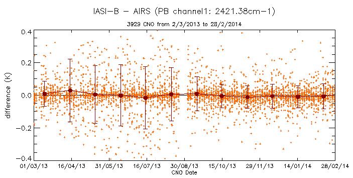

41 Temporal Evolution of IASI/AIRS and IASI/CRIS B1 B2 B3 IASI-A / CRIS IASI-B / CRIS IASI-A / AIRS IASI-B / AIRS 41 All couples are very stable with time
42 IASI-A / IASI-B through AIRS and CRIS Combination of IASI / AIRS and IASI / CRIS for IASI-B / IASI-A IASI-B / CRIS IASI-A / CRIS IASI-B / AIRS IASI-A / AIRS All biases agree: ~0.1K Confirms the very good cross calibration Always an effect on B1, IASI origin? Small differences in B1: dataset selection, e.g. colder? Direct IASI-B / IASI-A 42
43 Status of IASI inter-calibration The tool for inter-comparison is operational for the 5 couples of sensors: IASI-A / IASI-B, IASI-A / AIRS, IASI-B / AIRS, IASI-A / CRIS, IASI-B / CRIS Major results: very accurate cross-calibration! IASI-B very close to IASI-A (bias < ~0.1K) continuity of the IASI mission IASI / AIRS / CRIS: Bias between 0K and 0.2K, < radiometric absolute specification of 0.5K Cal/val results are confirmed with a larger and more diverse dataset All are very stable with time Largest bias in IASI B1, stronger in IASI-B: non-linearity in IASI? The observed bias is still high for climatic time series On-going work: Go further in the interpretation of the shape of the bias curves: Specific sensitivity studies for B1 are scheduled Update of the linearity tables Get the bias curves for each IASI pixel Exploit the IASI / AIRS and IASI / CRIS at high spectral resolution Uncertainty complete budget Go further in an absolute radiometric and spectral calibration 43
44 44 Thank you for your attention!
CNES WGCV-36 Report Cal/Val Activities
 CEOS WGCV Meeting 13-17th May 2013, Shangai, China CNES WGCV-36 Report Cal/Val Activities Bertrand Fougnie, Sophie Lachérade, Denis Jouglet, Eric Péquignot, Aimé Meygret, Patrice Henry CNES 1 Summary Pleiades
Physical Model to Describe the PARASOL Radiometric Trending. Definition, Adjustment, and Validation
 Physical Model to Describe the PARASOL Radiometric Trending Definition, Adjustment, and Validation Bertrand Fougnie CNES CALCON 13 Summary The PARASOL instrument & mission Evidences a of radiometric drift
In-flight Calibration Techniques Using Natural Targets. CNES Activities on Calibration of Space Sensors
 In-flight Calibration Techniques Using Natural Targets CNES Activities on Calibration of Space Sensors Bertrand Fougnie, Patrice Henry (DCT/SI, CNES, Toulouse, France) In-flight Calibration using Natural
Sentinel-2 and Sentinel-3 absolute calibration monitoring. C. Desjardins & V. Lonjou CNES
 Sentinel-2 and Sentinel-3 absolute calibration monitoring C. Desjardins & V. Lonjou CNES Radiometric S2A Calibration RRQI, 28 January Workshop, 2016, 30-31/08/2017 CNES SUMMARY CALCON Aug 22-25 2017 VICARIOUS
CNES Activity Report. Patrice Henry - CNES WGCV Plenary # 41 Tokyo Sept. 5-7, Working Group on Calibration and Validation
 Activity Report Patrice Henry - Tokyo Sept. 5-7, 2016 Working Group on Calibration and Validation SUMMARY Calibration Monitoring of in-flight Missions Preparation of future Missions Involvement in CEOS/WGCV
In-flight Evaluation of the SPOT-6 Radiometric Calibration based on Acquisitions over Natural Targets and Automated in-situ Measurements
 In-flight Evaluation of the SPOT-6 Radiometric Calibration based on Acquisitions over Natural Targets and Automated in-situ Measurements Philippe GAMET, Bertrand FOUGNIE, Sophie LACHERADE (CNES), Mathieu
Climatology of Oceanic Zones Suitable for In-flight Calibration of Space Sensors
 1 Climatology of Oceanic Zones Suitable for In-flight Calibration of Space Sensors Bertrand Fougnie* a, Jérome Llido b, Lydwine Gross-Colzy b, Patrice Henry a, Denis Blumstein a a Centre National d Etudes
CALIBRATION over the Moon An introduction to «POLO»
 CALIBRATION over the Moon An introduction to «POLO» Sophie Lachérade Bertrand Fougnie Aimé Meygret CEOS - IVOS 25, Frascati, 19-21 march 2013 Introduction It has been demonstrated that the Moon is a very
Traceability to the GIRO and ROLO
 EOS Traceability to the GIRO and ROLO Jack Xiong (NASA) In collaboration with Tom Stone (USGS) Sébastien Wagner, Tim Hewison (EUMETSAT) Sophie Lachérade, Bertrand Fougnie (CNES) GSICS Lunar Calibration
POLO Pleiades Orbital Lunar Observations. Intensive Study of the Moon and Comparison to ROLO Model
 POLO Pleiades Orbital Lunar Observations Intensive Study of the Moon and Comparison to ROLO Model Sophie Lachérade - CNES Ouahid Aznay CS Bertrand Fougnie - CNES 22nd CALCON Technical Conference August
MODIS and VIIRS Reflective Solar Calibration Update
 MODIS and VIIRS Reflective Solar Calibration Update X. Xiong 1, C. Cao 2, A. Angal 3, S. Blonski 4, N. Lei 3, W. Wang 4, Z. Wang 3, and A. Wu 3 1 NASA GSFC, MD 20771, USA; 2 NOAA NESDIS, MD 20740, USA
GOSAT mission schedule
 GOSAT mission schedule 29 21 12 1 2 3 4 6 7 8 9 1 11 12 1 2 214 1 2 3 ~ Jan. 23 Launch Initial Checkout Initial function check Initial Cal. and Val. Mission life Normal observation operation Extra Operati
Global Space-based Inter-Calibration System (GSICS) Infrared Reference Sensor Traceability and Uncertainty
 Infrared Reference Sensor Traceability and Uncertainty") Global Space-based Inter-Calibration System (GSICS) Infrared Reference Sensor Traceability and Uncertainty Tim Hewison (EUMETSAT) Thomas Pagano (NASA/JPL) Dave Tobin (NOAA/CIMSS) Masaya Takahashi (JMA)
Global Space-based Inter-Calibration System (GSICS) Infrared Reference Sensor Traceability and Uncertainty Tim Hewison (EUMETSAT) Thomas Pagano (NASA/JPL) Dave Tobin (NOAA/CIMSS) Masaya Takahashi (JMA)
MERIS, A-MODIS, SeaWiFS, AATSR and PARASOL over the Salar de Uyuni March 2006 MAVT 2006 Marc Bouvet, ESA/ESTEC
 MERIS, A-MODIS, SeaWiFS, AATSR and PARASOL over the Salar de Uyuni Plan of the presentation 1. Introduction : from absolute vicarious calibration to radiometric intercomparison 2. Intercomparison at TOA
Cross-calibration of Geostationary Satellite Visible-channel Imagers Using the Moon as a Common Reference
 Cross-calibration of Geostationary Satellite Visible-channel Imagers Using the Moon as a Common Reference Thomas C. Stone U.S. Geological Survey, Flagstaff AZ, USA 27 30 August, 2012 Motivation The archives
EUMETSAT GPRC Report. Tim Hewison, Marianne Koenig, Sebastien Wagner, Rob Roebeling, Peter Miu, Jörg Schulz, Harald Rothfuss EUMETSAT
 EUMETSAT GPRC Report Tim Hewison, Marianne Koenig, Sebastien Wagner, Rob Roebeling, Peter Miu, Jörg Schulz, Harald Rothfuss EUMETSAT Slide: 1 Overview Satellite Status GEO LEO IR Products for current Meteosats
Calibration of Ocean Colour Sensors
 Dr. A. Neumann German Aerospace Centre DLR Remote Sensing Technology Institute Marine Remote Sensing What is Calibration, why do we need it? Sensor Components Definition of Terms Calibration Standards
Outcome of the GSICS/CEOS-IVOS Lunar Calibration Workshop
 Outcome of the GSICS/CEOS-IVOS Lunar Calibration Workshop S. Wagner a, T. Hewison a, T. Stone b, S. Lachérade c, B. Fougnie c, X. Xiong d With the support of M. Takahashi JMA (1-year visiting scientist
VIIRS Radiometric Calibration for Reflective Solar Bands: Antarctic Dome C Site and Simultaneous Nadir Overpass Observations
 VIIRS Radiometric Calibration for Reflective Solar Bands: Antarctic Dome C Site and Simultaneous Nadir Overpass Observations Slawomir Blonski, * Changyong Cao, Sirish Uprety, ** and Xi Shao * NOAA NESDIS
Sentinel-3: Lessons from AATSR/MERIS Synergy. Peter North Swansea University
 Sentinel-3: Lessons from AATSR/MERIS Synergy Peter North Swansea University Introduction ESA projects relevant to Sentinel-3: Aerosol CCI MERIS/AATSR Synergy GlobAlbedo SEN4LST S3 Algorithm development
Sentinel-3 Sea and Land Surface Temperature Radiometer (SLSTR) Mireya Etxaluze (STFC RAL Space)
 Mireya Etxaluze (STFC RAL Space)") Sentinel-3 Sea and Land Surface Temperature Radiometer (SLSTR) Mireya Etxaluze (STFC RAL Space) RAL Space Radiometry Group Dave Smith Mireya Etxaluze, Ed Polehampton, Caroline Cox, Tim Nightingale, Dan
Sentinel-3 Sea and Land Surface Temperature Radiometer (SLSTR) Mireya Etxaluze (STFC RAL Space) RAL Space Radiometry Group Dave Smith Mireya Etxaluze, Ed Polehampton, Caroline Cox, Tim Nightingale, Dan
(A)ATSR and SLSTR VIS/SWIR Channels Calibration
ATSR and SLSTR VIS/SWIR Channels Calibration") (A)ATSR and SLSTR VIS/SWIR Channels Calibration Dave Smith & Mireya Etxaluze 2017 RAL Space 1 ATSR Series 1991-2000 ATSR-1 1995-2008 ATSR-2 2002-2012- AATSR 2 SLSTR Series 2016 Sentinel 3A 2018 Sentinel
(A)ATSR and SLSTR VIS/SWIR Channels Calibration Dave Smith & Mireya Etxaluze 2017 RAL Space 1 ATSR Series 1991-2000 ATSR-1 1995-2008 ATSR-2 2002-2012- AATSR 2 SLSTR Series 2016 Sentinel 3A 2018 Sentinel
EUMETSAT GPRC Report. Jo Schmetz Tim Hewison, Sebastien Wagner, Rob Roebeling, Peter Miu, Simon Elliot, Harald Rothfuss, Bartolomeo Viticchie EUMETSAT
 EUMETSAT GPRC Report Jo Schmetz Tim Hewison, Sebastien Wagner, Rob Roebeling, Peter Miu, Simon Elliot, Harald Rothfuss, Bartolomeo Viticchie EUMETSAT Slide: 1 Overview Satellite Status Calibration Support
Post-launch Radiometric and Spectral Calibration Assessment of NPP/CrIS by comparing CrIS with VIIRS, AIRS, and IASI
 Post-launch Radiometric and Spectral Calibration Assessment of NPP/CrIS by comparing CrIS with VIIRS, AIRS, and IASI Likun Wang 1, Yong Han 2, Denis Tremblay 3, Fuzhong Weng 2, and Mitch Goldberg 4 1.
ESA/MERIS vicarious adjustment
 ESA/MERIS vicarious adjustment Constant Mazeran (ACRI-ST Consultant) Christophe Lerebourg (ACRI-ST), Jean-Paul-Huot (ESA) David Antoine (CNRS-LOV, France & Curtin University, Perth, Australia) Ocean Colour
Status of Libya-4 Activities - RAL
 Status of Libya-4 Activities - RAL Dr David L Smith Preparation for reprocessing AATSR Long term drift correction LUT version 2.09 implemented in reprocessing V3.00 available based on revised BRF modelling
GMES: calibration of remote sensing datasets
 GMES: calibration of remote sensing datasets Jeremy Morley Dept. Geomatic Engineering jmorley@ge.ucl.ac.uk December 2006 Outline Role of calibration & validation in remote sensing Types of calibration
EUMETSAT AGENCY REPORT 2014/15 INSTRUMENT CAL/VAL ACTIVITIES
 1 WGCV Plenary #39, Berlin, May 2015 EUMETSAT AGENCY REPORT 2014/15 INSTRUMENT CAL/VAL ACTIVITIES J. Ackermann, S. Elliott, T. Hewison, K. Holmlund, V. John, R. Munro, P. Miu, A. O Carroll, R. Roebeling,
The VENμS mission: Earth Observation with High Spatial and Temporal Resolution Capabilities
 Ben Gurion University The VENμS mission: Earth Observation with High Spatial and Temporal Resolution Capabilities G. Dedieu 1, O. Hagolle 2, A. Karnieli 3, S. Cherchali 2 P. Ferrier 2 and Y. Yaniv 4 1
GSICS UV Sub-Group Activities
 GSICS UV Sub-Group Activities Rosemary Munro with contributions from NOAA, NASA and GRWG UV Subgroup Participants, in particular L. Flynn 1 CEOS Atmospheric Composition Virtual Constellation Meeting (AC-VC)
Current Application of Vicarious Calibration for Geostationary Ocean Color Imager (GOCI) DATA
 DATA") Current Application of Vicarious Calibration for Geostationary Ocean Color Imager (GOCI) DATA On behalf of Jae-Hyun Ahn & Young-je Park, Seongick CHO(Secondment at Astrium SAS, France) Korea Ocean Satellite
Current Application of Vicarious Calibration for Geostationary Ocean Color Imager (GOCI) DATA On behalf of Jae-Hyun Ahn & Young-je Park, Seongick CHO(Secondment at Astrium SAS, France) Korea Ocean Satellite
First Lunar Results from the Moon & Earth Radiation Budget Experiment (MERBE)
") First Lunar Results from the Moon & Earth Radiation Budget Experiment (MERBE) Grant Matthews Accelerating certainty in climate change prediction GSICS Lunar cal meeting 6 th Dec 2016 Overview "The single
First Lunar Results from the Moon & Earth Radiation Budget Experiment (MERBE) Grant Matthews Accelerating certainty in climate change prediction GSICS Lunar cal meeting 6 th Dec 2016 Overview "The single
EUMETSAT AGENCY REPORT 2014/15 GSICS ACTIVITIES
 1 GSICS-EP-16, Boulder, May 2015 EUMETSAT AGENCY REPORT 2014/15 GSICS ACTIVITIES J. Ackermann, S. Elliott, T. Hewison, K. Holmlund, V. John, R. Munro, P. Miu, A. O Carroll, R. Roebeling, H. Rothfuss, B.
Improved Confidence on the PLEIADES In-flight Absolute Calibration Through the Merging of Different Vicarious Calibration Methods
 Improved Confidence on the PLEIADES In-flight Absolute Calibration Through the Merging of Different Vicarious Calibration Methods 22 nd CALCON TechnicalConference August 2013, Logan, UT Sophie Lachérade
VIIRS SDR Cal/Val: S-NPP Update and JPSS-1 Preparations
 VIIRS SDR Cal/Val: S-NPP Update and JPSS-1 Preparations VIIRS SDR Cal/Val Posters: Xi Shao Zhuo Wang Slawomir Blonski ESSIC/CICS, University of Maryland, College Park NOAA/NESDIS/STAR Affiliate Spectral
Vicarious Calibration for MERIS 4 th Reprocessing
 Vicarious Calibration for MERIS 4 th Reprocessing Nicolas Lamquin on behalf of MERIS Quality Working Group FRM4SOC Options for future European satellite OCR vicarious adjustment infrastructure for the
C M E M S O c e a n C o l o u r S a t e l l i t e P r o d u c t s
 Implemented by C M E M S O c e a n C o l o u r S a t e l l i t e P r o d u c t s This slideshow gives an overview of the CMEMS Ocean Colour Satellite Products Marine LEVEL1 For Beginners- Slides have been
S3-A OLCI Cyclic Performance Report. Cycle No Start date: 20/12/2017. End date: 16/01/2018
 PREPARATION AND OPERATIONS OF THE MISSION PERFORMANCE CENTRE (MPC) FOR THE COPERNICUS SENTINEL-3 MISSION Start date: 20/12/2017 End date: 16/01/2018 Contract: 4000111836/14/I-LG Customer: ESA Document
Tracking On-orbit Radiometric Accuracy and Stability of Suomi NPP VIIRS using Extended Low Latitude SNOs
 Tracking On-orbit Radiometric Accuracy and Stability of Suomi NPP VIIRS using Extended Low Latitude SNOs Sirish Uprety a Changyong Cao b Slawomir Blonski c Xi Shao c Frank Padula d a CIRA, Colorado State
Ocean Colour: Calibration Approach. CEOS WGCV-39, May The International Ocean Colour Coordinating Group
 Ocean Colour: Calibration Approach CEOS WGCV-39, May 2015 The International Ocean Colour Coordinating Group Ocean Colour requires special calibration considerations Percentage of ocean signal in the total
THE METOP SECOND GENERATION 3MI MISSION
 THE METOP SECOND GENERATION 3MI MISSION Ilias Manolis, Jean-Loup Bézy, Maurizio Betto, Hubert Barré and Graeme Mason European Space Agency, ESTEC, Keplerlaan 1, 2200 AG Noordwijk ZH, The Netherlands Abstract
S3-A OLCI Cyclic Performance Report. Cycle No Start date: 03/09/2017. End date: 30/09/2017
 PREPARATION AND OPERATIONS OF THE MISSION PERFORMANCE CENTRE (MPC) FOR THE COPERNICUS SENTINEL-3 MISSION Start date: 03/09/2017 End date: 30/09/2017 Contract: 4000111836/14/I-LG Customer: ESA Document
S3-A OLCI Cyclic Performance Report. Cycle No Start date: 14/06/2017. End date: 11/07/2017
 PREPARATION AND OPERATIONS OF THE MISSION PERFORMANCE CENTRE (MPC) FOR THE COPERNICUS SENTINEL-3 MISSION Start date: 14/06/2017 End date: 11/07/2017 Contract: 4000111836/14/I-LG Customer: ESA Document
NOAA MSU/AMSU Radiance FCDR. Methodology, Production, Validation, Application, and Operational Distribution. Cheng-Zhi Zou
 NOAA MSU/AMSU Radiance FCDR Methodology, Production, Validation, Application, and Operational Distribution Cheng-Zhi Zou NOAA/NESDIS/Center for Satellite Applications and Research GSICS Microwave Sub-Group
Extending the Deep Blue aerosol record from SeaWiFS and MODIS to NPP-VIIRS
 Extending the Deep Blue aerosol record from SeaWiFS and MODIS to NPP-VIIRS Andrew M. Sayer, N. Christina Hsu (PI), Corey Bettenhausen, Jaehwa Lee Climate & Radiation Laboratory, NASA Goddard Space Flight
Inter-satellite Calibration of NOAA HIRS Level-1b Data for the Development of Climate Data Records
 Inter-satellite Calibration of NOAA Level-1b Data for the Development of Climate Data Records Ruiyue (Roy) Chen 1, Changyong Cao 2, and Paul Menzel 3 1 I.M. System Group at NOAA/NESDIS/STAR 2 NOAA/NESDIS/STAR
Cloud masking as cross-cutting issue
 Cloud masking as cross-cutting issue Presentation to CEOS/WGCV activity project planning meeting Rainer Hollmann, Cornelia Schlundt, Satellite based Climate Monitoring Deutscher Wetterdienst Outline Need
Status of S-NPP VIIRS Solar and Lunar Calibration
 Status of S-NPP VIIRS Solar and Lunar Calibration X. Xiong 1, N. Lei 2, J. Fulbright 2, and Z. Wang 2 1 NASA Goddard Space Flight Center, Greenbelt, MD 20771, USA 2 Science Systems and Applications Inc.,
ESA Climate Change Initiative (CCI)
") ESA Climate Change Initiative (CCI) New ESA Programme with the aim to contribute to worldwide efforts to generate Essential Climate Variables (ECVs) C. Zehner Barcelona, 07/09/2009 Two climate action paths
ESA Climate Change Initiative (CCI) New ESA Programme with the aim to contribute to worldwide efforts to generate Essential Climate Variables (ECVs) C. Zehner Barcelona, 07/09/2009 Two climate action paths
Satellite Position Determination of LEO Spacecraft
 Satellite Position Determination of LEO Spacecraft S.C.Rathnakara ISRO Satellite Centre 5 th September, 2007 International Committee on Global Navigation Satellite Systems(ICG) Things to follow Brief background
Update on GSICS Inter Calibration Product Development
 Special Issue of the IEEE TGRS on Inter-Calibration of Satellite Instruments : Update on GSICS Inter Calibration Product Development Tim Hewison (EUMETSAT) [GSICS Research Working Group Chair] Dave Doelling
Minutes of the First Meeting. of the IOCCG Working Group. L1 Requirements for Ocean-Colour Remote Sensing. April 20-21, 2010
 Minutes of the First Meeting of the IOCCG Working Group L1 Requirements for Ocean-Colour Remote Sensing April 20-21, 2010 Bethesda, Maryland (Washington, D.C.), USA Participants: - Charles R. McClain (chair,
GOSAT update. June Prepared by JAXA EORC Presented by David Crisp
 CEOS AC-VC GOSAT update June Prepared by JAXA EORC Presented by David Crisp GOSAT & GOSAT-2 Organization ORGANIZATION GOSAT is the joint project of JAXA, MOE (Ministry of the Environment) and NIES (National
Status of ESA EO Programmes
 Status of ESA EO Programmes 54 th ESSC Plenary Meeting 24 November 2017 Maurice Borgeaud, ESA Head of the ESA Earth Observation Science, Applications and Climate Department Issue/Revision: 0.0 Reference:
Cloud screening and snow detection with MERIS. Rene Preusker, Jürgen Fischer, Carsten Brockmann, Marco Zühlke, Uwe krämer, Anja Hünerbein
 Cloud screening and snow detection with MERIS Rene Preusker, Jürgen Fischer, Carsten Brockmann, Marco Zühlke, Uwe krämer, Anja Hünerbein Prelude The following algorithm has been compiled in the frame of
S3-A OLCI Cyclic Performance Report. Cycle No Start date: 27/10/2017. End date: 23/11/2017
 PREPARATION AND OPERATIONS OF THE MISSION PERFORMANCE CENTRE (MPC) FOR THE COPERNICUS SENTINEL-3 MISSION Start date: 27/10/2017 End date: 23/11/2017 Contract: 4000111836/14/I-LG Customer: ESA Document
Polar Multi-Sensor Aerosol Product: User Requirements
 Polar Multi-Sensor Aerosol Product: User Requirements Doc.No. Issue : : EUM/TSS/REQ/13/688040 v2 EUMETSAT EUMETSAT Allee 1, D-64295 Darmstadt, Germany Tel: +49 6151 807-7 Fax: +49 6151 807 555 Telex: 419
Accuracy and Precision Requirements for Climate-Level Data Sets
 Accuracy and Precision Requirements for Climate-Level Data Sets K. Thome NASA/GSFC Libya-4 Workshop Paris, France October 4-5, 2012 Accuracy requirements Commercial imagers Precision and SNR drive calibration
The Ozone Mapping and Profiler Suite (OMPS): From SNPP to JPSS-1
: From SNPP to JPSS-1") The Ozone Mapping and Profiler Suite (OMPS): From SNPP to JPSS-1 *C. Pan 1 and F. Weng 2 Curtsey of BATC Aerosol Index * 1 ESSIC, University of Maryland, College Park, MD 20740; 2 NOAA NESDIS/STAR, College
The Ozone Mapping and Profiler Suite (OMPS): From SNPP to JPSS-1 *C. Pan 1 and F. Weng 2 Curtsey of BATC Aerosol Index * 1 ESSIC, University of Maryland, College Park, MD 20740; 2 NOAA NESDIS/STAR, College
Estimation of ocean contribution at the MODIS near-infrared wavelengths along the east coast of the U.S.: Two case studies
 GEOPHYSICAL RESEARCH LETTERS, VOL. 32, L13606, doi:10.1029/2005gl022917, 2005 Estimation of ocean contribution at the MODIS near-infrared wavelengths along the east coast of the U.S.: Two case studies
MERIS SURFACE PRESSURE AND CLOUD FLAG: PRESENT STATUS AND IMPROVEMENTS
 ABSTRACT MERIS SURFACE PRESSURE AND CLOUD FLAG: PRESENT STATUS AND IMPROVEMENTS D. Ramon (1), R. Santer (2), P. Dubuisson (2) (1) HYGEOS, 191 rue N. Appert, 59650 Villeneuve d Ascq, FRANCE, dr@hygeos.com
Recent Update on MODIS C6 and VIIRS Deep Blue Aerosol Products
 Recent Update on MODIS C6 and VIIRS Deep Blue Aerosol Products N. Christina Hsu, Photo taken from Space Shuttle: Fierce dust front over Libya Corey Bettenhausen, Andrew M. Sayer, and Rick Hansell Laboratory
Deimos-2 Post-launch radiometric calibration
 Deimos-2 Post-launch radiometric Jorge Gil Alfredo Romo Cristina Moclán Fabrizio Pirondini (Elecnor Deimos Imaging) ELECNOR DEIMOS, Spain JACIE 2015 14th Annual Civil Commercial Imagery Evaluation Workshop
S3-A OLCI Cyclic Performance Report. Cycle No Start date: 25/03/2017. End date: 21/04/2017
 PREPARATION AND OPERATIONS OF THE MISSION PERFORMANCE CENTRE (MPC) FOR THE COPERNICUS SENTINEL-3 MISSION Start date: 25/03/2017 End date: 21/04/2017 Contract: 4000111836/14/I-LG Customer: ESA Document
In-flight Spectral Calibration of MERIS/OLCI. Jürgen Fischer, Rene Preusker, Rasmus Lindstrot Institute for Space Science Free University Berlin
 In-flight Spectral Calibration of MERIS/OLCI Jürgen Fischer, Rene Preusker, Rasmus Lindstrot Institute for Space Science Free University Berlin 1 MERIS Instrument 2 MERIS Instrument Concept 3 MERIS Operation
Status of VIIRS Reflective Solar Bands On-orbit Calibration and Performance
 EOS Status of VIIRS Reflective Solar Bands On-orbit Calibration and Performance X. Xiong 1, J. Fulbright 2, N. Lei 2, J. Sun 2, Z. Wang 2, and J. McIntire 2 1. NASA/GSFC, Greenbelt, MD 20771, USA 2. Sigma
Climate working group
 Climate working group Peter Thorne (Co-Chair), Jörg Schulz (Co- Chair), Hartmut Aumann, Denis Blumstein, Laure Chaumat, Cyril Crevoisier, Viju John, Anton Kaifel, Dieter Klaes, Steve Mango, Marc Schröder,
Julia Figa-Saldaña & Klaus Scipal
 Julia Figa-Saldaña & Klaus Scipal julia.figa@eumetsat.int klaus.scipal@esa.int Meeting, Outline MetOp/EPS status MetOp/EPS Second Generation status 2016 scatterometer conference Other European ocean programme
Bayesian Methodology for Atmospheric Correction of PACE Ocean-Color Imagery
 Bayesian Methodology for Atmospheric Correction of PACE Ocean-Color Imagery Robert Frouin, PI Scripps Institution of Oceanography, University of California San Diego, La Jolla, USA Bruno Pelletier, Co-I
FY-2 On-orbit Operational Calibration Approach (CIBLE) and its Benefit to FY-2D/E AMV Products
 and its Benefit to FY-2D/E AMV Products") 12 th International Winds Workshop (IWW12) Calibration of Inner Blackbody corrected by Lunar Emission (CIBLE) FY-2 On-orbit Operational Calibration Approach (CIBLE) and its Benefit to FY-2D/E AMV Products
12 th International Winds Workshop (IWW12) Calibration of Inner Blackbody corrected by Lunar Emission (CIBLE) FY-2 On-orbit Operational Calibration Approach (CIBLE) and its Benefit to FY-2D/E AMV Products
The LSA-SAF Albedo products
 The LSA-SAF Albedo products G. Jacob, D. Carrer & J.-L. Roujean CNRM-GAME, Météo France, Toulouse 2 Outline Method for retrieval Theoretical Framework Available Input BRDF Inversion Algorithm overview
Update of Terra and Aqua MODIS and S-NPP VIIRS On-orbit Calibration
 Update of Terra and Aqua MODIS and S-NPP VIIRS On-orbit Calibration X. Xiong 1, C. Cao 2, A. Angal 3, K. Chiang 3, N. Lei 3, G. Lin 3, Z. Wang 3, and A Wu 3 1 NASA GSFC, MD 20771, USA; 2 NOAA NESDIS, MD
Instrumentation planned for MetOp-SG
 Instrumentation planned for MetOp-SG Bill Bell Satellite Radiance Assimilation Group Met Office Crown copyright Met Office Outline Background - the MetOp-SG programme The MetOp-SG instruments Summary Acknowledgements:
The AEOLUS Mission - In Orbit Commissioning and Verification
 The AEOLUS Mission - In Orbit Commissioning and Verification ADM-Aeolus CAL/VAL Workshop, ESRIN P McGoldrick, J Brewster, J Marshall, F Fabre Airbus Defence and Space, UK and France 12 th February 2015
Lessons learnt from the validation of Level1 and Level2 hyperspectral sounders observations
 http://ara.abct.lmd.polytechnique.fr/ Lessons learnt from the validation of Level1 and Level2 hyperspectral sounders observations N. A. Scott, R. Armante, A. Chédin, N. Jacquinet, V. Capelle, A. Feofilov,
AIRS observations of Dome Concordia in Antarctica and comparison with Automated Weather Stations during 2005
 AIRS observations of Dome Concordia in Antarctica and comparison with Automated Weather Stations during 2005, Dave Gregorich and Steve Broberg Jet Propulsion Laboratory California Institute of Technology
Monitoring CO 2 Sources and Sinks from Space with the Orbiting Carbon Observatory (OCO)
") NACP Remote Sensing Breakout Monitoring CO 2 Sources and Sinks from Space with the Orbiting Carbon Observatory (OCO) http://oco.jpl.nasa.gov David Crisp, OCO PI (JPL/Caltech) January 2007 1 of 14, Crisp,
NACP Remote Sensing Breakout Monitoring CO 2 Sources and Sinks from Space with the Orbiting Carbon Observatory (OCO) http://oco.jpl.nasa.gov David Crisp, OCO PI (JPL/Caltech) January 2007 1 of 14, Crisp,
Report from CMA 16th GSICS Executive Panel, Boulder, May 2015
 Report from CMA 16th GSICS Executive Panel, Boulder, 15-16 May 215 Peng Zhang CMA/NSMC CMA Agency update in 214 Overall satellite planning FY-3C commissioning finished in March, 214 and operational running
NOAA Report. Hal Bloom Mitch Goldberg NOAA/NESDIS
 NOAA Report Hal Bloom Mitch Goldberg NOAA/NESDIS Summary of Major Events at NESDIS (of interest to ITSC) NOAA/NASA addressing NPOESS Climate Sensors Letter of agreement signed with JAXA on GCOM interagency
EUMETSAT STATUS AND PLANS
 1 EUM/TSS/VWG/15/826793 07/10/2015 EUMETSAT STATUS AND PLANS François Montagner, Marine Applications Manager, EUMETSAT WMO Polar Space Task Group 5 5-7 October 2015, DLR, Oberpfaffenhofen PSTG Strategic
NEW CGMS BASELINE FOR THE SPACE-BASED GOS. (Submitted by the WMO Secretariat) Summary and Purpose of Document
 Summary and Purpose of Document") WORLD METEOROLOGICAL ORGANIZATION COMMISSION FOR BASIC SYSTEMS OPEN PROGRAMME AREA GROUP ON INTEGRATED OBSERVING SYSTEMS EXPERT TEAM ON SATELLITE SYSTEMS ET-SAT-7/Inf. 2 (12.III.2012) ITEM: 8.1 SEVENTH
WORLD METEOROLOGICAL ORGANIZATION COMMISSION FOR BASIC SYSTEMS OPEN PROGRAMME AREA GROUP ON INTEGRATED OBSERVING SYSTEMS EXPERT TEAM ON SATELLITE SYSTEMS ET-SAT-7/Inf. 2 (12.III.2012) ITEM: 8.1 SEVENTH
NIR Solar Reference Spectrum Algorithm for the Orbiting Carbon Observatory (OCO)
") NIR Solar Reference Spectrum Algorithm for the Orbiting Carbon Observatory (OCO) Hartmut Bösch and Geoffrey Toon Jet Propulsion Laboratory, California Institute of Technology OCO Mission Global, space-based
NIR Solar Reference Spectrum Algorithm for the Orbiting Carbon Observatory (OCO) Hartmut Bösch and Geoffrey Toon Jet Propulsion Laboratory, California Institute of Technology OCO Mission Global, space-based
SCIAMACHY REFLECTANCE AND POLARISATION VALIDATION: SCIAMACHY VERSUS POLDER
 SCIAMACHY REFLECTANCE AND POLARISATION VALIDATION: SCIAMACHY VERSUS POLDER L. G. Tilstra (1), P. Stammes (1) (1) Royal Netherlands Meteorological Institute (KNMI), P.O. Box 201, 3730 AE de Bilt, The Netherlands
MSG system over view
 MSG system over view 1 Introduction METEOSAT SECOND GENERATION Overview 2 MSG Missions and Services 3 The SEVIRI Instrument 4 The MSG Ground Segment 5 SAF Network 6 Conclusions METEOSAT SECOND GENERATION
ADVANCEMENTS IN SNOW MONITORING
 Polar Space Task Group ADVANCEMENTS IN SNOW MONITORING Thomas Nagler, ENVEO IT GmbH, Innsbruck, Austria Outline Towards a pan-european Multi-sensor Snow Product SnowPEx Summary Upcoming activities SEOM
Status of Indian Satellite Meteorological Programme
 Status of Indian Satellite Meteorological Programme Pradeep K Thapliyal Space Applications Centre (SAC) Indian Space research Organisation (ISRO) Ahmedabad (INDIA) Email: pkthapliyal@sac.isro.gov.in International
A Comparative Study and Intercalibration Between OSMI and SeaWiFS
 A Comparative Study and Intercalibration Between OSMI and SeaWiFS KOMPSAT-1 Bryan A. Franz NASA SIMBIOS Project Yongseung Kim Korea Aerospace Research Institute ORBVIEW-2 Abstract Since 1996, following
MODIS and VIIRS Reflective Solar Bands Calibration, Performance, and Inter-comparison
 EOS MODIS and VIIRS Reflective Solar Bands Calibration, Performance, and Inter-comparison Jack Xiong 1, Aisheng Wu 1, and Changyong Cao 2 1. NASA/GSFC; 2. NOAA/STAR Other Contributors: NASA MCST and VCST
Status of the Sentinel-5 Precursor Presented by C. Zehner S5p, S4, and S5 Missions Manager - ESA
 Status of the Sentinel-5 Precursor Presented by C. Zehner S5p, S4, and S5 Missions Manager - ESA European response to global needs: to manage the environment, to mitigate the effects of climate change
Eight Years MOS-IRS Summary of Calibration Activities
 Eight Years MOS-IRS Summary of Calibration Activities Workshop on Inter-Comparison of Large Scale Optical and Infrared Sensors 12 14 October 2004, ESA / ESTEC Noordwijk, The Netherlands Horst Schwarzer,
ASCAT - Metop A developments, Metop B preparations & EPS-SG
 ASCAT - Metop A developments, Metop B preparations & EPS-SG Hans Bonekamp, Craig Anderson, Julia Figa & Julian Wilson Slide: 1 ASCAT Metop A - overview Instrument operating nominally (minor incident in
GSICS in CMA. Peng ZHANG, Xiuqing Hu, Ling Sun, Lin Chen, Na Xu, Yuan Li, Chengli Qi, Qiang Guo etc
 GSICS in CMA Peng ZHANG, Xiuqing Hu, Ling Sun, Lin Chen, Na Xu, Yuan Li, Chengli Qi, Qiang Guo etc National Satellite Meteorological Center, CMA July 15-16, Tokyo, Japan Outline GSICS history in CMA Current
The Moon & Earth Radiation Budget Experiment (MERBE)
") The Moon & Earth Radiation Budget Experiment (MERBE) Grant Matthews Animation credit Wikipedia Accelerating certainty in climate change prediction Overview New concept of MERBE, using existing data decades
The Moon & Earth Radiation Budget Experiment (MERBE) Grant Matthews Animation credit Wikipedia Accelerating certainty in climate change prediction Overview New concept of MERBE, using existing data decades
The Copernicus Sentinel-5 Mission: Daily Global Data for Air Quality, Climate and Stratospheric Ozone Applications
 SENTINEL-5 The Copernicus Sentinel-5 Mission: Daily Global Data for Air Quality, Climate and Stratospheric Ozone Applications Yasjka Meijer RHEA for ESA, Noordwijk, NL 15/04/2016 Co-Authors: Jörg Langen,
GCOM-C SGLI calibration and characterization. Hiroshi Murakami JAXA/EORC Satellite instrument pre- and post-launch calibration
 GCOM-C SGLI calibration and characterization Hiroshi Murakami JAXA/EORC Satellite instrument pre- and post-launch calibration 1 1. SGLI sensor system and onboard calibration system Target: Improvement
EUMETSAT Activities Related to Climate
 EUMETSAT Activities Related to Climate Jörg Schulz joerg.schulz@eumetsat.int Slide: 1 What we do USER REQUIREMENTS European National Meteorological Services Operating Agency! European Space Industry Private
OCEAN COLOUR MONITOR ON-BOARD OCEANSAT-2
 OCEAN COLOUR MONITOR ON-BOARD OCEANSAT-2 Rangnath R Navalgund Space Applications Centre Indian Space Research Organisation Ahmedabad-380015, INDIA OCEANSAT-2 2 MISSION OCEANSAT-2 2 is a global mission
The Orbiting Carbon Observatory (OCO)
") GEMS 2006 Assembly The Orbiting Carbon Observatory (OCO) http://oco.jpl.nasa.gov David Crisp, OCO PI (JPL/Caltech) February 2006 1 of 13, OCO Dec 2005 Page 1 The Orbiting Carbon Observatory (OCO) OCO will
GEMS 2006 Assembly The Orbiting Carbon Observatory (OCO) http://oco.jpl.nasa.gov David Crisp, OCO PI (JPL/Caltech) February 2006 1 of 13, OCO Dec 2005 Page 1 The Orbiting Carbon Observatory (OCO) OCO will
Chapter 4 Nadir looking UV measurement. Part-I: Theory and algorithm
 Chapter 4 Nadir looking UV measurement. Part-I: Theory and algorithm -Aerosol and tropospheric ozone retrieval method using continuous UV spectra- Atmospheric composition measurements from satellites are
Ground-based Validation of spaceborne lidar measurements
 Ground-based Validation of spaceborne lidar measurements Ground-based Validation of spaceborne lidar measurements to make something officially acceptable or approved, to prove that something is correct