*C. Pan 1, F. Weng 2, T. Beck 2 and S. Ding 3
|
|
|
- Felicity McBride
- 5 years ago
- Views:
Transcription


1 S NPP Ozone Mapping Profiler Suite Nadir Instrument Radiometric Calibration *C. Pan 1, F. Weng 2, T. Beck 2 and S. Ding 3 Curtsey of Ball Aerospace and Technologies Corp. * 1 ESSIC, University of Maryland, College Park, MD 20740; 2 NOAA NESDIS/STAR, College Park, MD 20740; 3 ERT, Laurel MD Aerosol Index The Fourth Annual CICS MD Science Meeting College Park, MD20740 Ozone map So2 index This study was supported by NOAA grant NA09NES /23/2015 (Cooperative Institute for Climate and Satellites CICS) 1


2 OMPS is one of four instruments on board the SNPP satellite launched in Oct J1 OMPS will launch in early OMPS has three spectrometers: NP, NM and LP. Heritage from SBUV/2 and TOM, OMPS provides ozone total column and vertical profile data that continues ozone daily global data with higher calibration accuracy and higher spatial and spectral resolution. Configuration i Push-broom 110 deg. cross-track FOV telescope Two grating spectrometers» NM covers 300 nm to 380 nm» NP covers 250 nm to 310 nm CCD optical detector for each spectrometer Spatial resolution can be altered to provide a smaller ground FOV that has a higher spatial resolution. Onboard Calibrators Light-emitting diode provides linearity calibration Reflective solar diffusers maintain calibration stability Nadir Mapper Courtesy of BATC 11/23/2015 2


3 NM OMPS Focal Plane CCD operation temperature: 30 deg. for TC and 45 deg. for NP Split frame transfer, two halves identical CCD Le ft H a lf Right Half OMPS NM CCD readout full frame image format. 35 spatial cells in the cross track direction, covers 110 deg FOV 11/23/2015 3
4 OMPS Nadir performance specifications Dominant contribution to accuracy Dominant contribution to precision Spatial Properties Radiometric Precision Terms Cross track MTF at nadir >.5 at.01cycles/km SNR 1000 for TC, varies for NP Cross track TC macpx. IFOV nadir <3.44 degrees Inter orbital Thermal Wavelength Shift Cross track ktc FOV >110 degrees.02 nm Radiometric Accuracy Geolocation Error Terms Pixel pixel radiometric calibration <.5% Boresight alignment knowledge Non linearity 2% full well uncertainty between nadir NL knowledge <.5% instrument interface and nadir alignment reference On orbit wavelength calibration.01 nm <160 arcsec Stray Light TC OOB + OOF response <2% Total cumulative boresight alignment Intra orbit wavelength stability.02 nm Band Pass Shape Knowledge 2% Solar Irradiance < 7% Radiance <3% shift (between final ground calibration and on orbit operations <500 arcsec 11/23/2015 4
5 OMPS Sensor Radiometric calibration Prelaunch calibration Prelaunch calibration consists of three principal phases: irradiance calibration, goniometry characterization and radiance calibration. Each OMPS spectrometer was calibrated by transferring NIST traceable standards to the sensors in both radiance and irradiance modes. The irradiance coefficients were measured using a similar method to the radiance measurement. OMPS radiometric calibration uncertainties come from the calibrators and the measurements, such as calibrators stability, sphere strike to strike repeatability, wavelength calibration accuracy, stray light contamination, signal correction accuracy and signal to noise ratio. Courtesy of BATC Dark Dark distribution Dark generate rates Electronic bias Hot pixels Dark Signal Nonuniformity (DSNU) Readout noise Dark smear Linearity i Nonlinearity LED output drifts Dynamic range Calibrated accuracy LED lamp warm up behavior LED illumination uniformity CCD gain 11/23/2015 5

6 OMPS Sensor Radiometric calibration Orbital calibration The in flight calibration provides an observed solar irradiance spectrum along with the measured Earth radiances from Earth observation. Orbital calibration employed two diffusers for each spectrometer to maintain calibration stability A working diffuser and a reference diffuser operate in a different observation frequency to tack sensor optical degradation and diffuser degradation The solar measurement provide time dependent solar irradiance, wavelength, and sensor stability monitoring Major challenge is orbital wavelength variation: Ground to orbital transition, seasonal, intra orbit, cross track Courtesy of S. J. Lipscy from BATC Backscatter UV retrievals use a normalized radiance, a ratio of measured Earth radiance to measured solar irradiance. 11/23/2015 6
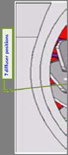

7 Solar irradiance measurements 7

8 Optical throughput change < 1% NP Reference Working NM 8
9 Dichroic wavelength changed ~ 0.1 nm from ground to orbit Wavelength shifted ~ 0.1 nm from ground to orbit. The figure shows percent difference between observed and synthetic solar flux Percent transmittance Measured vs. Synthetic Solar Flux 9

 that represents what OMPS should provide Wavelength dependent accuracy in cross track scan direction exceed")
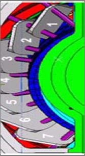
10 Cross track position pattern from normalized radiance OMP data is compared with data from the well calibrated Microwave Limb Sounder (MLS) Using MLS ozone and temperature profiles colocated with OMPS retrievals under the OMPS viewing conditions, a calibration standard is established through radiative transfer model dltomrad. The model computes the normalized radiance (NR) that represents what OMPS should provide Wavelength dependent accuracy in cross track scan direction exceed our expectation but can be corrected. The figure shows percent difference between OMPS and MLS before SDR validated maturity 11/23/
11 Cross-Track Dependence in SO2 Index Cross track position pattern from EDR datar SO2 Index before wavelength update INCTO SOI 2015/07/

12 Wavelength changed spectrally and spatially Shifts vs. spectral channels Shifts vs. spatial 35 cells 11/23/


13 Cross track position pattern from Solar data before adjustment After adjustment cross track pos cross track pos


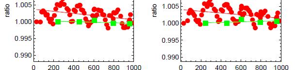
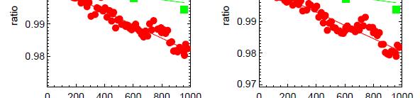
14 Reduced Cross-Track Dependence in OMPS NM Derived EDR (SO2) SO2 Index Comparison before and after Wavelength Update SO2 index cross-track variation was minimized from -13 ~ 13 to 6~7/8. Previous data Residual error are caused by EDR V7 TOZ algorithm, that t inappropriately exaggerates the impact of wavelength variation. The residual error can be corrected by EDR V8 algorithm with an appropriate n-value adjustment. t Updated data Data comes from OMPS NM EDR products INCTO SO2 2015/07/01 14
15 Wavelength dependent Cross Track Normalized Radiance Error Meets Requirement k Difference for Earth View N-Value or Radiance Normalized radiance error is percent difference between Observed and Calculated N values Figures shows the errors for 6 different cross track (CT) positions CT position #1 CT position #35 Courtesy of NASA Errors were minimized < 2% for most of the channels. Except ion is CT#36 on wavelength > 360 nm. Soft calibration are being implemented to eliminate this residual error. 15
16 Summary Summary Sensor orbital performance is stable and meet our expectation Radiometric calibration includes dichroic adjustments, stray light correction, wavelength shift corrections Summar and radiance/irradiance calibration coefficients modification The cross-track direction normalized radiance accuracy y meets spec and the error is less than 2.0% with updated dwavelength and day one solar LUTs The NM and NP consistency in nm has been improved by 2-10% with updated radiance calibration coefficients Newly established calibration validation method via radiative transfer model is critical for SDR products assessment 16
The Ozone Mapping and Profiler Suite (OMPS): From SNPP to JPSS-1
: From SNPP to JPSS-1") The Ozone Mapping and Profiler Suite (OMPS): From SNPP to JPSS-1 *C. Pan 1 and F. Weng 2 Curtsey of BATC Aerosol Index * 1 ESSIC, University of Maryland, College Park, MD 20740; 2 NOAA NESDIS/STAR, College
The Ozone Mapping and Profiler Suite (OMPS): From SNPP to JPSS-1 *C. Pan 1 and F. Weng 2 Curtsey of BATC Aerosol Index * 1 ESSIC, University of Maryland, College Park, MD 20740; 2 NOAA NESDIS/STAR, College
Sumi-NPP OMPS Calibration and Characterization from Early Orbit Images
 Sumi-NPP OMPS Calibration and Characterization from Early Orbit Images *C. Pan 1, F. Weng 2, X. Wu 2, L. Flynn 2, G. Jaross 3 and S. Janz 4 * 1 ESSIC, University of Maryland, College Park, MD 20740 2 NOAA
SBUV(/2) and SSBUV Solar Irradiance Measurements Matthew DeLand, Richard Cebula, Liang-Kang Huang Science Systems and Applications, Inc.
 and SSBUV Solar Irradiance Measurements Matthew DeLand, Richard Cebula, Liang-Kang Huang Science Systems and Applications, Inc.") SBUV(/2) and SSBUV Solar Irradiance Measurements Matthew DeLand, Richard Cebula, Liang-Kang Huang Science Systems and Applications, Inc. (SSAI) Solar Spectral Irradiance Variations Workshop NIST, Gaithersburg,
SBUV(/2) and SSBUV Solar Irradiance Measurements Matthew DeLand, Richard Cebula, Liang-Kang Huang Science Systems and Applications, Inc. (SSAI) Solar Spectral Irradiance Variations Workshop NIST, Gaithersburg,
GSICS UV Sub-Group Activities
 GSICS UV Sub-Group Activities Rosemary Munro with contributions from NOAA, NASA and GRWG UV Subgroup Participants, in particular L. Flynn 1 CEOS Atmospheric Composition Virtual Constellation Meeting (AC-VC)
GCOM-C SGLI calibration and characterization. Hiroshi Murakami JAXA/EORC Satellite instrument pre- and post-launch calibration
 GCOM-C SGLI calibration and characterization Hiroshi Murakami JAXA/EORC Satellite instrument pre- and post-launch calibration 1 1. SGLI sensor system and onboard calibration system Target: Improvement
VIIRS SDR Cal/Val: S-NPP Update and JPSS-1 Preparations
 VIIRS SDR Cal/Val: S-NPP Update and JPSS-1 Preparations VIIRS SDR Cal/Val Posters: Xi Shao Zhuo Wang Slawomir Blonski ESSIC/CICS, University of Maryland, College Park NOAA/NESDIS/STAR Affiliate Spectral
Calibration of Ocean Colour Sensors
 Dr. A. Neumann German Aerospace Centre DLR Remote Sensing Technology Institute Marine Remote Sensing What is Calibration, why do we need it? Sensor Components Definition of Terms Calibration Standards
Status of S-NPP VIIRS Solar and Lunar Calibration
 Status of S-NPP VIIRS Solar and Lunar Calibration X. Xiong 1, N. Lei 2, J. Fulbright 2, and Z. Wang 2 1 NASA Goddard Space Flight Center, Greenbelt, MD 20771, USA 2 Science Systems and Applications Inc.,
Status of VIIRS Reflective Solar Bands On-orbit Calibration and Performance
 EOS Status of VIIRS Reflective Solar Bands On-orbit Calibration and Performance X. Xiong 1, J. Fulbright 2, N. Lei 2, J. Sun 2, Z. Wang 2, and J. McIntire 2 1. NASA/GSFC, Greenbelt, MD 20771, USA 2. Sigma
Chapter 4 Nadir looking UV measurement. Part-I: Theory and algorithm
 Chapter 4 Nadir looking UV measurement. Part-I: Theory and algorithm -Aerosol and tropospheric ozone retrieval method using continuous UV spectra- Atmospheric composition measurements from satellites are
NOAA Cal/Val Progress Update
 NOAA Cal/Val Progress Update Xi Shao 1,2 and Changyong Cao 2 1. University of Maryland 2. NOAA/NESDIS/STAR With contributions from NOAA/NESDIS/STAR Scientists Presented at the WGCV-36, Shanghai, China,
Solar Cycle 24 Variability Observed by Aura OMI Matthew DeLand and Sergey Marchenko Science Systems and Applications, Inc. (SSAI)
") Solar Cycle 24 Variability Observed by Aura OMI Matthew DeLand and Sergey Marchenko Science Systems and Applications, Inc. (SSAI) 2014 SORCE Science Meeting Cocoa Beach, FL 28-31 January 2014 Solar Measurements
Solar Cycle 24 Variability Observed by Aura OMI Matthew DeLand and Sergey Marchenko Science Systems and Applications, Inc. (SSAI) 2014 SORCE Science Meeting Cocoa Beach, FL 28-31 January 2014 Solar Measurements
Science Team Evaluation of the OMPS Limb Profiler
 Status Report to NASA Headquarters Science Team Evaluation of the OMPS Limb Profiler Pawan K. Bhartia 1 and Glen Jaross 1 Jack Larsen 2, Al Fleig 3 1 Earth Sciences Division- Atmosphere NASA Goddard Space
GCOM-C/SGLI and its Lunar Calibration
 GCOM-C/SGLI and its Lunar Calibration Lunar Calibration Workshop December 1-4, 2014 JAXA/GCOM Proj. Yoshihiko Okamura (okamura.yoshihiko@jaxa.jp) 1. Overview of GCOM-C satellite and SGLI (1) Global Change
Post-launch Radiometric and Spectral Calibration Assessment of NPP/CrIS by comparing CrIS with VIIRS, AIRS, and IASI
 Post-launch Radiometric and Spectral Calibration Assessment of NPP/CrIS by comparing CrIS with VIIRS, AIRS, and IASI Likun Wang 1, Yong Han 2, Denis Tremblay 3, Fuzhong Weng 2, and Mitch Goldberg 4 1.
The Compact Infrared Imager and Radiometer
 The Compact Infrared Imager and Radiometer Earth System Science from a 6U nanosat? Neil Bowles (Univ. Oxford) On behalf of the CIIR Consortium. 22 April 2015 CEOI-ST Technology 1 The Why study a tightly
624 SNPP VIIRS Solar Diffuser BRDF Degradation Trend Changes in Early Evan Haas* and Frank De Luccia The Aerospace Corporation, El Segundo CA
 624 SNPP VIIRS Solar Diffuser BRDF Degradation Trend Changes in Early 2014 1. INTRODUCTION Evan Haas* and Frank De Luccia The Aerospace Corporation, El Segundo CA The Visible Infrared Imaging Radiometer
Landsat-8 Operational Land Imager (OLI) Initial On-Orbit Performance
 Initial On-Orbit Performance") Landsat-8 Operational Land Imager (OLI) Initial On-Orbit Performance Geir Kvaran, Ed Knight, Khurrum Ansari, Kenton Lee, Brent Canova, Brian Donley Ball Aerospace & Technologies Corp. Hugh Kieffer Celestial
Landsat-8 Operational Land Imager (OLI) Initial On-Orbit Performance Geir Kvaran, Ed Knight, Khurrum Ansari, Kenton Lee, Brent Canova, Brian Donley Ball Aerospace & Technologies Corp. Hugh Kieffer Celestial
MODIS Reflective Solar Bands Calibration Algorithm and On-orbit Performance
 MODIS Reflective Solar Bands Calibration Algorithm and On-orbit Performance X. (Jack) Xiong* a, J. Sun a, J. Esposito a, B. Guenther b, and W. Barnes c a Science Systems and Applications, Inc., 10210 Greenbelt
SCIAMACHY IN-FLIGHT CALIBRATION
 SCIAMACHY IN-FLIGHT CALIBRATION Ralph Snel SRON Netherlands Institute for Space Research Sorbonnelaan 2, 3584 CA Utrecht, the Netherlands Email: R.Snel@sron.nl ABSTRACT The options for SCIAMACHY in-flight
A Comparative Study and Intercalibration Between OSMI and SeaWiFS
 A Comparative Study and Intercalibration Between OSMI and SeaWiFS KOMPSAT-1 Bryan A. Franz NASA SIMBIOS Project Yongseung Kim Korea Aerospace Research Institute ORBVIEW-2 Abstract Since 1996, following
Developing Vicarious Calibration for Microwave Sounding Instruments using Lunar Radiation
 CICS Science Meeting, College Park, 2017 Developing Vicarious Calibration for Microwave Sounding Instruments using Lunar Radiation Hu(Tiger) Yang Contributor: Dr. Jun Zhou Nov.08, 2017 huyang@umd.edu Outline
HICO Science Mission Overview
 HICO Science Mission Overview Michael R. Corson* and Curtiss O. Davis** * Naval Research Laboratory Washington, DC corson@nrl.navy.mil ** College of Oceanic and Atmospheric Sciences Oregon State University
Suomi NPP VIIRS SDR postlaunch cal/val - Overview of progress and challenges
 Suomi NPP VIIRS SDR postlaunch cal/val - Overview of progress and challenges Changyong Cao 1, Jack Xiong 2, Fuzhong Weng 1, Bruce Guenther 1, and Jim Butler 2 1 NOAA, 2 NASA August 30, 2012 Sample VIIRS
An Overview Of The Ozone Mapping And Profiler Suite (OMPS) And Its Science Products. Laura Dunlap
 And Its Science Products. Laura Dunlap") An Overview Of The Ozone Mapping And Profiler Suite (OMPS) And Its Science Products Laura Dunlap A scholarly paper in partial fulfillment of the requirements for the degree of Master of Science December
An Overview Of The Ozone Mapping And Profiler Suite (OMPS) And Its Science Products Laura Dunlap A scholarly paper in partial fulfillment of the requirements for the degree of Master of Science December
Ground and On-Orbit Characterization and Calibration of the Geosynchronous Imaging Fourier Transform Spectrometer (GIFTS)
") Ground and On-Orbit Characterization and Calibration of the Geosynchronous Imaging Fourier Transform Spectrometer (GIFTS) John D. Elwell 1, Deron K. Scott 1 Henry E. Revercomb 2, Fred A. Best 2, Robert
Ground and On-Orbit Characterization and Calibration of the Geosynchronous Imaging Fourier Transform Spectrometer (GIFTS) John D. Elwell 1, Deron K. Scott 1 Henry E. Revercomb 2, Fred A. Best 2, Robert
MODIS and VIIRS Reflective Solar Calibration Update
 MODIS and VIIRS Reflective Solar Calibration Update X. Xiong 1, C. Cao 2, A. Angal 3, S. Blonski 4, N. Lei 3, W. Wang 4, Z. Wang 3, and A. Wu 3 1 NASA GSFC, MD 20771, USA; 2 NOAA NESDIS, MD 20740, USA
NIR Solar Reference Spectrum Algorithm for the Orbiting Carbon Observatory (OCO)
") NIR Solar Reference Spectrum Algorithm for the Orbiting Carbon Observatory (OCO) Hartmut Bösch and Geoffrey Toon Jet Propulsion Laboratory, California Institute of Technology OCO Mission Global, space-based
NIR Solar Reference Spectrum Algorithm for the Orbiting Carbon Observatory (OCO) Hartmut Bösch and Geoffrey Toon Jet Propulsion Laboratory, California Institute of Technology OCO Mission Global, space-based
Validation of ozone profile retrievals derived from the OMPS LP version 2.5 algorithm against correlative satellite measurements
 Validation of ozone profile retrievals derived from the OMPS LP version 2. algorithm against correlative satellite measurements Natalya A. Kramarova 1,2, Pawan K. Bhartia 2, Glen Jaross 2, Leslie Moy 1,
Joint Polar Satellite System. 3 rd Post-EPS User Consultation Workshop Mike Haas
 3 rd Post-EPS User Consultation Workshop Mike Haas Overview Introduction - Policy Drivers - Management System Description - Space Segment - Ground Segment Partnerships Status Benefits 2 Introduction (Policy
HARP Assessment of Uncertainty
 HARP Assessment of Uncertainty The HIAPER Airborne Radiation Package (HARP) was designed to produce accurate measurements of actinic flux and irradiance. The Atmospheric Radiation Group (ARG) at the University
Overview of Hyperion On-Orbit Instrument Performance, Stability, and Artifacts
 Overview of Hyperion On-Orbit Instrument Performance, Stability, and Artifacts EO-1 Science Validation Team Meeting November 21, 2002 Debbie Beiso TRW Space and Electronics Redondo Beach, CA San Francisco
MERIS US Workshop. Instrument Characterization Overview. Steven Delwart
 MERIS US Workshop Instrument Characterization Overview Steven Delwart Presentation Overview On-Ground Characterisation 1. Diffuser characterisation 2. Polarization sensitivity 3. Optical Transmission 4.
The on-ground calibration of the Ozone Monitoring Instrument from a scientific point of view
 The on-ground calibration of the Ozone Monitoring Instrument from a scientific point of view Ruud Dirksen *ab, Marcel Dobber a, Pieternel Levelt a, Gijsbertus van den Oord a, Glen Jaross c, Matt Kowalewski
McIDAS support of Suomi-NPP /JPSS and GOES-R L2
 McIDAS support of Suomi-NPP /JPSS and GOES-R L2 William Straka III 1 Tommy Jasmin 1, Bob Carp 1 1 Cooperative Institute for Meteorological Satellite Studies, Space Science and Engineering Center, University
GOME-2 COMMISSIONING RESULTS: GEOPHYSICAL VALIDATION OF LEVEL 1 PRODUCTS
 GOME-2 COMMISSIONING RESULTS: GEOPHYSICAL VALIDATION OF LEVEL 1 PRODUCTS Rosemary Munro (1), Rüdiger Lang (1), Yakov Livschitz (1), Michael Eisinger (2), Abelardo Pérez-Albiñana (1) (1) EUMETSAT, Darmstadt,
MODIS On-orbit Calibration Methodologies
 MODIS On-orbit Calibration Methodologies Jack Xiong and Bill Barnes NASA/GSFC, Greenbelt, MD 20771, USA University of Maryland, Baltimore County, Baltimore MD, 21250, USA (Support provided by entire MCST
Mission Objectives and Current Status of GOSAT (IBUKI) Japan Aerospace Exploration Agency Yasushi Horikawa
 Japan Aerospace Exploration Agency Yasushi Horikawa") Mission Objectives and Current Status of GOSAT (IBUKI) Japan Aerospace Exploration Agency Yasushi Horikawa 1 Background of the Launch of the GOSAT project 1997 Adoption of the Kyoto Protocol 2002 Ratification
Mission Objectives and Current Status of GOSAT (IBUKI) Japan Aerospace Exploration Agency Yasushi Horikawa 1 Background of the Launch of the GOSAT project 1997 Adoption of the Kyoto Protocol 2002 Ratification
NPP ATMS Instrument On-orbit Performance
 NPP ATMS Instrument On-orbit Performance K. Anderson, L. Asai, J. Fuentes, N. George Northrop Grumman Electronic Systems ABSTRACT The first Advanced Technology Microwave Sounder (ATMS) was launched on
GOSAT update. June Prepared by JAXA EORC Presented by David Crisp
 CEOS AC-VC GOSAT update June Prepared by JAXA EORC Presented by David Crisp GOSAT & GOSAT-2 Organization ORGANIZATION GOSAT is the joint project of JAXA, MOE (Ministry of the Environment) and NIES (National
Pre-Launch Characterization and In-orbit Calibration of GCOM-C/SGLI
 Pre-Launch Characterization and In-orbit Calibration of GCOM-C/SGLI IGARSS 2018 July 26, 2018 Japan Aerospace Exploration Agency Yoshihiko Okamura T. Hashiguchi, T. Urabe, K. Tanaka (JAXA) J Yoshida, T
ECE 583 Lecture 12. Mie Theory (cont.) Mie Theory. m( ) = n( )-ik( )
 Mie Theory. m( ) = n( )-ik( )") ISSUES FOR AEROSOL DISTRIBUTION ECE 583 Lecture 12 Aerosol Size Distribution Retrieval Advanced Instrument Design Airborne Solar Photometers Solar Occultation from Space A given aerosol particle is characterized
ISSUES FOR AEROSOL DISTRIBUTION ECE 583 Lecture 12 Aerosol Size Distribution Retrieval Advanced Instrument Design Airborne Solar Photometers Solar Occultation from Space A given aerosol particle is characterized
CIRiS: Compact Infrared Radiometer in Space LCPM, August 16, 2017 David Osterman PI, CIRiS Mission
 1 CIRiS: Compact Infrared Radiometer in Space LCPM, August 16, 2017 David Osterman PI, CIRiS Mission 8/15/201 7 Overview of the CIRiS instrument and mission The CIRiS instrument is a radiometric thermal
Calibration demonstration system for an imaging spectrometer to provide climatequality
 Calibration demonstration system for an imaging spectrometer to provide climatequality reflectance K. Thome, J. McCorkel, J. Hair, B. McAndrew, A. Daw, D. Jennings, D. Rabin NASA/GSFC 1 Calibration Demonstration
First Lunar Results from the Moon & Earth Radiation Budget Experiment (MERBE)
") First Lunar Results from the Moon & Earth Radiation Budget Experiment (MERBE) Grant Matthews Accelerating certainty in climate change prediction GSICS Lunar cal meeting 6 th Dec 2016 Overview "The single
First Lunar Results from the Moon & Earth Radiation Budget Experiment (MERBE) Grant Matthews Accelerating certainty in climate change prediction GSICS Lunar cal meeting 6 th Dec 2016 Overview "The single
Traceability to the GIRO and ROLO
 EOS Traceability to the GIRO and ROLO Jack Xiong (NASA) In collaboration with Tom Stone (USGS) Sébastien Wagner, Tim Hewison (EUMETSAT) Sophie Lachérade, Bertrand Fougnie (CNES) GSICS Lunar Calibration
Application of Aura/OMI PBL SO 2 product for estimating SO 2 emissions and future enhancements from new satellite missions
 Application of Aura/OMI PBL SO 2 product for estimating SO 2 emissions and future enhancements from new satellite missions 1 N. Krotkov, 2 V. Fioletov, 3,1 K. Yang, 4,1 Can Li, 3 R. Dickerson & Aura/OMI
GOSAT mission schedule
 GOSAT mission schedule 29 21 12 1 2 3 4 6 7 8 9 1 11 12 1 2 214 1 2 3 ~ Jan. 23 Launch Initial Checkout Initial function check Initial Cal. and Val. Mission life Normal observation operation Extra Operati
Atmospheric Lidar The Atmospheric Lidar (ATLID) is a high-spectral resolution lidar and will be the first of its type to be flown in space.
 is a high-spectral resolution lidar and will be the first of its type to be flown in space.") www.esa.int EarthCARE mission instruments ESA s EarthCARE satellite payload comprises four instruments: the Atmospheric Lidar, the Cloud Profiling Radar, the Multi-Spectral Imager and the Broad-Band Radiometer.
www.esa.int EarthCARE mission instruments ESA s EarthCARE satellite payload comprises four instruments: the Atmospheric Lidar, the Cloud Profiling Radar, the Multi-Spectral Imager and the Broad-Band Radiometer.
Overview of Post-launch CrIS SDR Calibration and Validation
 Overview of Post-launch CrIS SDR Calibration and Validation Yong Han NOAA/ Center for Satellite Applications & Research and CrIS SDR Team CALCON Technical Conference Aug. 27 Aug. 30, 2012 Logan, Utah 1
Vicarious calibration of GLI by global datasets. Calibration 5th Group Hiroshi Murakami (JAXA EORC)
") Vicarious calibration of GLI by global datasets Calibration 5th Group Hiroshi Murakami (JAXA EORC) ADEOS-2 PI workshop March 2004 1 0. Contents 1. Background 2. Operation flow 3. Results 4. Temporal change
Vicarious calibration of GLI by global datasets Calibration 5th Group Hiroshi Murakami (JAXA EORC) ADEOS-2 PI workshop March 2004 1 0. Contents 1. Background 2. Operation flow 3. Results 4. Temporal change
Accuracy and Precision Requirements for Climate-Level Data Sets
 Accuracy and Precision Requirements for Climate-Level Data Sets K. Thome NASA/GSFC Libya-4 Workshop Paris, France October 4-5, 2012 Accuracy requirements Commercial imagers Precision and SNR drive calibration
The AMSU/MSU FCDR as an in-orbit reference for monitoring ATMS
 The AMSU/MSU FCDR as an in-orbit reference for monitoring ATMS Manik Bali, Cheng-Zhi Zou, Ralph Ferraro and Lawrence E. Flynn NOAA/NESDIS/STAR, College Park, USA CICS Science Meeting 2017 07 November,
Cross-calibration of Geostationary Satellite Visible-channel Imagers Using the Moon as a Common Reference
 Cross-calibration of Geostationary Satellite Visible-channel Imagers Using the Moon as a Common Reference Thomas C. Stone U.S. Geological Survey, Flagstaff AZ, USA 27 30 August, 2012 Motivation The archives
Calibration of MERIS on ENVISAT Status at End of 2002
 Calibration of MERIS on ENVISAT Status at End of 2002 Bourg L. a, Delwart S. b, Huot J-P. b a ACRI-ST, 260 route du Pin Montard, BP 234, 06904 Sophia-Antipolis Cedex, France b ESA/ESTEC, P.O. Box 299,
Tracking On-orbit Radiometric Accuracy and Stability of Suomi NPP VIIRS using Extended Low Latitude SNOs
 Tracking On-orbit Radiometric Accuracy and Stability of Suomi NPP VIIRS using Extended Low Latitude SNOs Sirish Uprety a Changyong Cao b Slawomir Blonski c Xi Shao c Frank Padula d a CIRA, Colorado State
Orbital Variation of Blackbody. VIIRS Thermal Emissive Band
 Orbital Variation of Blackbody Thermistor Temperature for S NPP VIIRS Thermal Emissive Band Calibration i Xi Shao 1, Changyong Cao 2, Slawomir Blonski 1, Quanhua (Mark) Liu 1 1. University of Maryland,
Update of Terra and Aqua MODIS and S-NPP VIIRS On-orbit Calibration
 Update of Terra and Aqua MODIS and S-NPP VIIRS On-orbit Calibration X. Xiong 1, C. Cao 2, A. Angal 3, K. Chiang 3, N. Lei 3, G. Lin 3, Z. Wang 3, and A Wu 3 1 NASA GSFC, MD 20771, USA; 2 NOAA NESDIS, MD
VIIRS Radiometric Calibration for Reflective Solar Bands: Antarctic Dome C Site and Simultaneous Nadir Overpass Observations
 VIIRS Radiometric Calibration for Reflective Solar Bands: Antarctic Dome C Site and Simultaneous Nadir Overpass Observations Slawomir Blonski, * Changyong Cao, Sirish Uprety, ** and Xi Shao * NOAA NESDIS
Global Space-based Inter-Calibration System (GSICS) Infrared Reference Sensor Traceability and Uncertainty
 Infrared Reference Sensor Traceability and Uncertainty") Global Space-based Inter-Calibration System (GSICS) Infrared Reference Sensor Traceability and Uncertainty Tim Hewison (EUMETSAT) Thomas Pagano (NASA/JPL) Dave Tobin (NOAA/CIMSS) Masaya Takahashi (JMA)
Global Space-based Inter-Calibration System (GSICS) Infrared Reference Sensor Traceability and Uncertainty Tim Hewison (EUMETSAT) Thomas Pagano (NASA/JPL) Dave Tobin (NOAA/CIMSS) Masaya Takahashi (JMA)
Ozone Monitoring Instrument in-flight performance and calibration
 Ozone Monitoring Instrument in-flight performance and calibration M. Dobber* a, R. Dirksen a,b, P. Levelt a, B. van den Oord a, R. Voors a, Q. Kleipool a, G. Jaross c, M. Kowalewski c a Royal Netherlands
(A)ATSR and SLSTR VIS/SWIR Channels Calibration
ATSR and SLSTR VIS/SWIR Channels Calibration") (A)ATSR and SLSTR VIS/SWIR Channels Calibration Dave Smith & Mireya Etxaluze 2017 RAL Space 1 ATSR Series 1991-2000 ATSR-1 1995-2008 ATSR-2 2002-2012- AATSR 2 SLSTR Series 2016 Sentinel 3A 2018 Sentinel
(A)ATSR and SLSTR VIS/SWIR Channels Calibration Dave Smith & Mireya Etxaluze 2017 RAL Space 1 ATSR Series 1991-2000 ATSR-1 1995-2008 ATSR-2 2002-2012- AATSR 2 SLSTR Series 2016 Sentinel 3A 2018 Sentinel
MODIS and VIIRS Reflective Solar Bands Calibration, Performance, and Inter-comparison
 EOS MODIS and VIIRS Reflective Solar Bands Calibration, Performance, and Inter-comparison Jack Xiong 1, Aisheng Wu 1, and Changyong Cao 2 1. NASA/GSFC; 2. NOAA/STAR Other Contributors: NASA MCST and VCST
GOME-2 processor version 7 for reprocessing campaign R3 - Lessons learnt from CalVal
 GOME-2 processor version 7 for reprocessing campaign R3 - Lessons learnt from CalVal Ruediger Lang, Gabriele Poli, Christian Retscher, Rasmus Lindstrot, Roger Huckle, Martin Tschimmel and Rosemary Munro
The steps to an uncertainty budget
 The steps to an uncertainty budget Emma Woolliams 4 April 2017 Prepared by Paul Miller http://www.emceoc.org Uncertainty Where to start? What to do? How to be consistent? Make it easy. At the end of this
Space Science and Engineering Center, University of Wisconsin-Madison, Madison, Wisconsin 1. INTRODUCTION
 695 SUOMI NPP/JPSS CROSS-TRACK INFRARED SOUNDER (CRIS): CALIBRATION VALIDATION WITH THE AIRCRAFT BASED SCANNING HIGH-RESOLUTION INTERFEROMETER SOUNDER (S-HIS) Joe K. Taylor *, H.E. Revercomb, D. C. Tobin,
5. Calibration & Monitoring
 5. Calibration & Monitoring Spaceborne spectral measurements over long time periods require to translate the measured signals into physical quantities and to maintain this process with high precision.
Wind Imaging Spectrometer and Humidity-sounder (WISH): a Practical and Effective NPOESS P3I Sensor
: a Practical and Effective NPOESS P3I Sensor") Wind Imaging Spectrometer and Humidity-sounder (WISH): a Practical and Effective NPOESS P3I Sensor Jeffery J. Puschell Raytheon Space and Airborne Systems Hung-Lung Huang University of Wisconsin, Madison
Wind Imaging Spectrometer and Humidity-sounder (WISH): a Practical and Effective NPOESS P3I Sensor Jeffery J. Puschell Raytheon Space and Airborne Systems Hung-Lung Huang University of Wisconsin, Madison
The Orbiting Carbon Observatory (OCO)
") GEMS 2006 Assembly The Orbiting Carbon Observatory (OCO) http://oco.jpl.nasa.gov David Crisp, OCO PI (JPL/Caltech) February 2006 1 of 13, OCO Dec 2005 Page 1 The Orbiting Carbon Observatory (OCO) OCO will
GEMS 2006 Assembly The Orbiting Carbon Observatory (OCO) http://oco.jpl.nasa.gov David Crisp, OCO PI (JPL/Caltech) February 2006 1 of 13, OCO Dec 2005 Page 1 The Orbiting Carbon Observatory (OCO) OCO will
TROPOMI. Sentinel 5 Precursor instrument for air quality and climate observations. R. Voors Dutch Space. ICSO, 11 October 2012
 TROPOMI Sentinel 5 Precursor instrument for air quality and climate observations R. Voors Dutch Space ICSO, 11 October 2012 Sentinel 5 precursor and the TROPOMI payload Climate and Air quality Precursor
Progress Towards an Absolute Calibration of Lunar Irradiance at Reflected Solar Wavelengths
 Progress Towards an Absolute Calibration of Lunar Irradiance at Reflected Solar Wavelengths Claire Cramer, Steve Brown, Keith Lykke, John Woodward (NIST) Tom Stone (USGS) Motivation for using the Moon
The EarthCARE mission: An active view on aerosols, clouds and radiation
 The EarthCARE mission: An active view on aerosols, clouds and radiation T. Wehr, P. Ingmann, T. Fehr Heraklion, Crete, Greece 08/06/2015 EarthCARE is ESA s sixths Earth Explorer Mission and will be implemented
Comparison of Results Between the Miniature FASat-Bravo Ozone Mapping Detector (OMAD) and NASA s Total Ozone Mapping Spectrometer (TOMS)
 and NASA s Total Ozone Mapping Spectrometer (TOMS)") Comparison of Results Between the Miniature FASat-Bravo Ozone Mapping Detector (OMAD) and NASA s Total Ozone Mapping Spectrometer (TOMS) Juan A. Fernandez-Saldivar, Craig I. Underwood Surrey Space Centre,
Comparison of Results Between the Miniature FASat-Bravo Ozone Mapping Detector (OMAD) and NASA s Total Ozone Mapping Spectrometer (TOMS) Juan A. Fernandez-Saldivar, Craig I. Underwood Surrey Space Centre,
Simulation of UV-VIS observations
 Simulation of UV-VIS observations Hitoshi Irie (JAMSTEC) Here we perform radiative transfer calculations for the UV-VIS region. In addition to radiance spectra at a geostationary (GEO) orbit, air mass
History of Aerosol Remote Sensing. Mark Smithgall Maria Zatko 597K Spring 2009
 History of Aerosol Remote Sensing Mark Smithgall Maria Zatko 597K Spring 2009 Aerosol Sources Anthropogenic Biological decomposition from fertilizer and sewage treatment (ex. ammonium) Combustion of fossil
Root Cause Determination of On-orbit Degradation of the VIIRS Rotating Telescope Assembly
 Root Cause Determination of On-orbit Degradation of the VIIRS Rotating Telescope Assembly M.R. Ciofalo, P.D. Fuqua, J.D. Barrie, M.J. Meshishnek, C.T. Chu, J.A. Chaney, and R.M. Moision, The Aerospace
Atmospheric Correction Using Hyperion
 Atmospheric Correction Using Hyperion Progress and Issues Investigation: Correlative Analysis of EO-1, Landsat, and Terra Data of the DOE ARM CART Sites: An Investigation of Instrument Performance and
Long-Term Time Series of Water Vapour Total Columns from GOME, SCIAMACHY and GOME-2
 Graphics: ESA Graphics: ESA Graphics: ESA Long-Term Time Series of Water Vapour Total Columns from GOME, SCIAMACHY and GOME-2 S. Noël, S. Mieruch, H. Bovensmann, J. P. Burrows Institute of Environmental
NOAA MSU/AMSU Radiance FCDR. Methodology, Production, Validation, Application, and Operational Distribution. Cheng-Zhi Zou
 NOAA MSU/AMSU Radiance FCDR Methodology, Production, Validation, Application, and Operational Distribution Cheng-Zhi Zou NOAA/NESDIS/Center for Satellite Applications and Research GSICS Microwave Sub-Group
In-flight Spectral Calibration of MERIS/OLCI. Jürgen Fischer, Rene Preusker, Rasmus Lindstrot Institute for Space Science Free University Berlin
 In-flight Spectral Calibration of MERIS/OLCI Jürgen Fischer, Rene Preusker, Rasmus Lindstrot Institute for Space Science Free University Berlin 1 MERIS Instrument 2 MERIS Instrument Concept 3 MERIS Operation
Status of Aqua MODIS Spatial Characterization and Performance
 Status of Aqua MODIS Spatial Characterization and Performance Xiaoxiong. Xiong, Nianzeng Che, William Barnes, Yong Xie, Lingli Wang, and John Qu Sciences and Exploration Directorate, NASA/GSFC, Greenbelt,
Thermal And Near infrared Sensor for carbon Observation (TANSO) On board the Greenhouse gases Observing SATellite (GOSAT) Research Announcement
 On board the Greenhouse gases Observing SATellite (GOSAT) Research Announcement") Thermal And Near infrared Sensor for carbon Observation (TANSO) On board the Greenhouse gases Observing SATellite (GOSAT) Research Announcement Appendix A Outlines of GOSAT and TANSO Sensor GOSAT (Greenhouse
Thermal And Near infrared Sensor for carbon Observation (TANSO) On board the Greenhouse gases Observing SATellite (GOSAT) Research Announcement Appendix A Outlines of GOSAT and TANSO Sensor GOSAT (Greenhouse
Angelika Dehn Rob Koopman 10 Years GOME on ERS-2 Workshop
 Angelika Dehn (ADehn@serco.it), Rob Koopman (Rob.Koopman@esa.int), Overview I. ERS-2 Mission History 1. Mission Plan Highlights 2. GOME Special Operations II. GOME-1 Engineering Performance 1. Routine
Uncertainties in Sentinel-3 Sea and Land Surface Temperature Radiometer Thermal Infrared Calibration
 Uncertainties in Sentinel-3 Sea and Land Surface Temperature Radiometer Thermal Infrared Calibration Dave Smith; Arrow Lee; Mireya Extaluze; Edward Polehampton; Tim Nightingale; Elliot Newman; Dan Peters
SHORT TERM SCIENTIFIC MISSION (STSM) SCIENTIFIC REPORT
 SCIENTIFIC REPORT") SHORT TERM SCIENTIFIC MISSION (STSM) SCIENTIFIC REPORT This report is submitted for approval by the STSM applicant to the STSM coordinator Action number: ES1309 STSM title: Laboratory based radiometric
SHORT TERM SCIENTIFIC MISSION (STSM) SCIENTIFIC REPORT This report is submitted for approval by the STSM applicant to the STSM coordinator Action number: ES1309 STSM title: Laboratory based radiometric
Minutes of the First Meeting. of the IOCCG Working Group. L1 Requirements for Ocean-Colour Remote Sensing. April 20-21, 2010
 Minutes of the First Meeting of the IOCCG Working Group L1 Requirements for Ocean-Colour Remote Sensing April 20-21, 2010 Bethesda, Maryland (Washington, D.C.), USA Participants: - Charles R. McClain (chair,
What are Aerosols? Suspension of very small solid particles or liquid droplets Radii typically in the range of 10nm to
 What are Aerosols? Suspension of very small solid particles or liquid droplets Radii typically in the range of 10nm to 10µm Concentrations decrease exponentially with height N(z) = N(0)exp(-z/H) Long-lived
The Meteor3M/ Stratospheric Aerosol and Gas Experiment III: A bridge to the future for long-term records of ozone and aerosol
 The Meteor3M/ Stratospheric Aerosol and Gas Experiment III: A bridge to the future for long-term records of ozone and aerosol S. Burton, E.W. Chiou, W. P. Chu, M. S. Cisewski, D. Flittner, N. Iyer, J.
The Earth Climate Hyperspectral Observatory: Advances in Climate Change Detection, Attribution, and Remote Sensing
 The Earth Climate Hyperspectral Observatory: Advances in Climate Change Detection, Attribution, and Remote Sensing Peter Pilewskie, Greg Kopp, Odele Coddington, Sebastian Schmidt, Tom Sparn University
HYPER Industrial Feasibility Study Final Presentation Precision Star Tracker Activity 3, WP 3100
 HYPER Industrial Feasibility Study Final Presentation Precision Star Tracker Activity 3, WP 3100 ESTEC, Noordwijk The Netherlands 6 -th March 2003 Agenda Introduction 1 PST Requirements 2 PST CCD Characteristics
NOAA Report. Hal Bloom Mitch Goldberg NOAA/NESDIS
 NOAA Report Hal Bloom Mitch Goldberg NOAA/NESDIS Summary of Major Events at NESDIS (of interest to ITSC) NOAA/NASA addressing NPOESS Climate Sensors Letter of agreement signed with JAXA on GCOM interagency
Pre-Launch Radiometric Characterization of JPSS-1 VIIRS Thermal Emissive Bands
 Article Pre-Launch Radiometric Characterization of JPSS-1 VIIRS Thermal Emissive Bands Jeff McIntire 1, *, David Moyer 2, Hassan Oudrari 1 and Xiaoxiong Xiong 3 Received: 28 October 2015; Accepted: 25
Ester Nikolla, Robert Knuteson, Michelle Feltz, and Henry Revercomb
 P62 Using IR Brightness Temperature Spectra to Disentangle the Effects of Ozone, Carbon Dioxide, and Water Vapor On Global Stratospheric Temperature Trends Ester Nikolla, Robert Knuteson, Michelle Feltz,
Operational systems for SST products. Prof. Chris Merchant University of Reading UK
 Operational systems for SST products Prof. Chris Merchant University of Reading UK Classic Images from ATSR The Gulf Stream ATSR-2 Image, ƛ = 3.7µm Review the steps to get SST using a physical retrieval
Deimos-2 Post-launch radiometric calibration
 Deimos-2 Post-launch radiometric Jorge Gil Alfredo Romo Cristina Moclán Fabrizio Pirondini (Elecnor Deimos Imaging) ELECNOR DEIMOS, Spain JACIE 2015 14th Annual Civil Commercial Imagery Evaluation Workshop
Inflight Radiometric Calibration: NASA Experience
 EOS Inflight Radiometric Calibration: NASA Experience Jack Xiong and Brian Markham Sciences and Exploration Directorate, NASA Goddard Space Flight Center Contributions: MODIS, VIIRS, and OLI Instrument
GMES: calibration of remote sensing datasets
 GMES: calibration of remote sensing datasets Jeremy Morley Dept. Geomatic Engineering jmorley@ge.ucl.ac.uk December 2006 Outline Role of calibration & validation in remote sensing Types of calibration
Spectral surface albedo derived from GOME-2/Metop measurements
 Spectral surface albedo derived from GOME-2/Metop measurements Bringfried Pflug* a, Diego Loyola b a DLR, Remote Sensing Technology Institute, Rutherfordstr. 2, 12489 Berlin, Germany; b DLR, Remote Sensing
S5P Mission Performance Centre Level 1b Readme
 S5P Mission Performance Centre Level 1b Readme document number issue 1.0.0 date 2018-07-10 product version status Prepared by Reviewed by Approved by V01.00.00 released N.C. Rozemeijer (KNMI), Q. Kleipool
THE GLI 380-NM CHANNEL APPLICATION FOR SATELLITE REMOTE SENSING OF TROPOSPHERIC AEROSOL
 THE GLI 380-NM CHANNEL APPLICATION FOR SATELLITE REMOTE SENSING OF TROPOSPHERIC AEROSOL Robert Höller, 1 Akiko Higurashi 2 and Teruyuki Nakajima 3 1 JAXA, Earth Observation Research and Application Center