Challenges and Limitations of Hydroclimatological Forecasting and the Relative Role of its Three Pillars: Models, Observations and Parameterization
|
|
|
- Oswald Webster
- 5 years ago
- Views:
Transcription


1 Challenges and Limitations of Hydroclimatological Forecasting and the Relative Role of its Three Pillars: Models, Observations and Parameterization Soroosh Sorooshian Center for Hydrometeorology and Remote Sensing - University of California Irvine CAHMDA/DAFOH Workshop Center for Integrated Earth System Science UT Austin Texas : Sept. 8 th -12 th 2014


2 University Research of Team: California Present Irvine and Recent (UCI) Past S. Sellars Center for Hydrometeorology and Remote Sensing, University of California, and Irvine many more

3 Climate, Hydrology and Water Resources How will Climate effect water Availability? Can we predict the future changes which are responsive to user needs?


4 Climate Model Downscaling to regional/watershed Scale Aggregation Precipitation Vegetation Topography Climate Model Grid-Scale GCM RCM DS Downscaling Land


5 Ensemble Approach Generation of Future Precipitation Scenarios

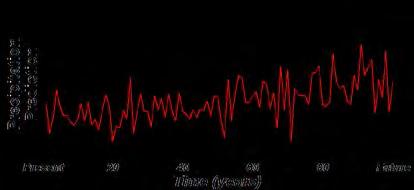
 Future Flow (cfs) Present")
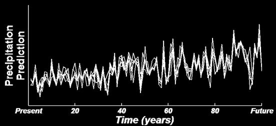
6 Downscaled Precipitation to Runoff Generation Generation of Future Runoff Scenarios Precipitation prediction (mm/day) Present Time (years) Future Flow (cfs) Present Time (years) Future
7 Brief Review of Rainfall Runoff modeling: Progress in Hydrologic Modeling


8 Hydrologic Modeling: 3 Elements! DATA If the World of Watershed Hydrology Was Perfect! MODEL PARAMETER ESTIMATION
9 Model Selection


10 Hydrologic Modeling Challenges Continental Scale: Focus of Hydro-Climate modelers Different Scales Different Issues Different Stakeholders Watershed Scale: Focus of Hydro-Met. Modeling Where hydrology happens


 VIC Model")
11 Evolution of Hydrologic R-R Models A D API Model B C Lumped Conceptual Distributed (Mike SHE) VIC Model Distributed Physically-based

12 Hydrologic Modeling: Lumped Observed Lumped Model Animation Assisted by: Q. Xia
13 Semi-distributed Hydrologic Models Runoff Combination Routing A B 5


14 Semi-distributed Hydrologic Models Observed Lumped Model Semi-Distributed Model Animation Assisted by: Q. Xia

15 Example of Distributed Model Appl. in large Basins Sub-basin 3 Large basin Sub-basin 1 Sub-basin 4 Sub-basin 2 a i R ek Srz Su Srz Su zq Srz Su v Srz Su zq Srz v zq Srz Srz Su Su Su Srz Srz zq Su zq Su v v zq Srz v zq Srz Su Su v v zq v zq zq Srz Su Srz v zq Srz zq Srz Su Su Su v Srz q zq Su v zq Srz Su Srz Su v v zq v zq Srz zq Srz v Su Su v q zq Srz zq Srz v Su Srz Su Srz v v v zq Su zq Srz zq Srz Su Su v Su v zq v v v zq Srz zq Srz v Su Srz Su v Srz zq Srz v Su zq Su zq Su Srz v v zq Srz zq Srz zq Srz v Su q Su Srz Su Srz v Su zq v zq Su zq Su Srz v v zq v v zq Srz zq Srz Su v Su v Su Srz v zq Su zq Srz grid-cell i Su Srz v zq Srz Su grid-cell Su v v zq zq zq Srz Srz Su v zq v v Su q v zq Srz Su q i v v zq v Srz Su zq q q v v v Srz zq Srz q v Su Su Srz Srz zq v v z qv Su Su v zq v zq Srz Su v zq Sub-basin k q v v SD i Funada, 2004

16 Example of Distributed Hydrologic Model Observed Lumped Model Distributed Model Animation Assisted by: Q. Xia


17 DMIP-1 Findings: In a Nutshell Sacramento Model No Major Difference between the performance of Lumped and distributed models DMIP 1 Results (From Reed et al., 2004)
18 Model Calibration/ Parameter Estimation
19 The Identification Problem 1. Select a model structure (Input-State-Output equations) 2. Estimate values for the parameters U Universal Set M 1 (θ) O The Truth D B - Basin O M i (θ) Selected Model Structure U M 2 (θ) D

20 Automatic Calibration components Objective Function Search Algorithm Sensitivity Analysis
 Generalized Likelihood Uncertainty Estimation (GLUE) method (Beven and co-workers) θ 1 (3) Markov Chain Monte Carlo (MCMC) methods (Vrugt and others) p( θ t.) p( θ t + 1.")
21 Parameter Uncertainty Methods (1) First-order approximations near global optimum (Kuczera etal) Limitations Assumes Model is Linear Assumes Posterior Dist. Guassian θ 2. (2) Generalized Likelihood Uncertainty Estimation (GLUE) method (Beven and co-workers) θ 1 (3) Markov Chain Monte Carlo (MCMC) methods (Vrugt and others) p( θ t.) p( θ t + 1.) θ t +1 t θ

22 Multi-Objective Approaches Inputs Model Outputs Radiation M(θ)

23 AGU Monograph Now Available
24 Data
25 Big Challenge Adequacy of Hydrologic Observations for model Input, Calibration and Testing
26 Among the 3 Pillars

27 A Key Requirement! Precipitation Measurement is one of the KEY hydrometeorologic Challenges Push towards High Resolution ( Spatial and Temporal) Global Observations and Modeling
 Rain gauge data: Precipitation")
 Radar data:")

28 Radar-Gauge Comparison (Walnut Gulch, AZ) Rain gauge data: Precipitation event: Aug. 11, 2000 Storm depth (mm) Radar data: Z=300R 1.4, 2.4 o elevation, HailThresh=56 dbz 70% overestimation by the radar! Morin et al ADWR 2005
29 Uncertainty in Runoff Simulation due to Rainfall Variability Small scale spatial variability of rainfall (on the order of ~150 m) Modeled runoff (KINEROS) (1 at a time) Aug. 3, 1990 Rain Gage Faures, JM et.al. J.of Hydrology 1995

30 Future Modeling Scenarios ( ) Western U.S. future model projections Dr. Chiyuan Miao - BNU
31 Future Modeling Scenarios IPCC AR5 Representative Concentration Pathways (RCP) Scenarios: RCP2.6: represent low scenarios featured by the radiative forcing of 2.6 W/m 2 by 2100, the resulting CO 2 - equivalent concentrations is 421 ppm in the year RCP4.5: represent medium scenarios featured by the radiative forcing of 4.5 W/m 2 by 2100, the resulting CO 2 - equivalent concentrations is 538 ppm in the year RCP8.5: represent high scenarios featured by the radiative forcing of 8.5 W/m 2 by 2100, the resulting CO 2 - equivalent concentrations is 936 ppm in the year CO 2 Concentrations (ppm) Historical RCP2.6 RCP4.5 RCP Time 936ppm 538ppm 421ppm


 GISS-E2-R")
32 RCP2.6 Time period: CNRM-CM5 (France GCM) CSIRO-MK (Australian GCM) GISS-E2-R (U.S. GCM) HadGEM2-ES (U.K. GCM)


33 RCP8.5 Time period: CNRM-CM5 (France GCM) CSIRO-MK (Australian GCM) GISS-E2-R (U.S. GCM) HadGEM2-ES (U.K. GCM)
34 Precipitation Estimation from Remotely Sensed Information using Artificial Neural Networks (PERSIANN) PERSIANN System Precipitation Estimation from Remotely Sensed Information using Artificial Neural Networks Kuolin Hsu Algorithm Development Bisher Imam G-WADI site development


35 PERSIANN-CCS (Real-time 4 km)
36 PERSIANN-CDR: Reconstruction of 30+ years of Daily, 0.25 o Satellite-Based Precipitation observation Ashouri et al., BAMS 2014 (to appear) Center for Hydrometeorology and Remote Sensing (CHRS)


37 PERSIANN-CDR: PERSIANN Climate Data Record

38 LEO Satellites for Precipitation Estimation Limited PMW Samples Before year 2000

")


 MET-9 (0 East)")


 MTSAT-1R(140 East)")
39 Source: NOAA NCDC Historical GEO Satellite Data International Satellite Cloud Climatology Project (ISCCP) 1979 to present 10-km and 3-hour intervals GOES-11 (135 West) GOES-12 (75 West) 1. U.S. Geostationary Operational Environmental Satellite (GOES) MET-9 (0 East) MET-7(57.5 East) 2. European Meteorological satellite (Meteosat) series 3. Japanese Geostationary Meteorological Satellite (GMS) MTSAT-1R(140 East) FY2-C(105 East) 4. The Chinese Fen-yung 2C (FY2) series.


 GPCP Bias Adjustment GPCP")
40 PERSIANN-CDR Algorithm A threshold on 3-hrly PERSIANN-B1 outputs. GridSat-B1 IRWIN High Temporal-Spatial Res. Cloud Infrared Images Artificial Neural Network PERSIANN 3-Hourly Rainfall (0.25 o x0.25 o ) PERSIANN Monthly Rainfall (2.5 o x2.5 o ) Adjusted PERSIANN 3-Hourly Rainfall (0.25 o x0.25 o ) GPCP Bias Adjustment GPCP Monthly Precipitation (2.5 o x2.5 o ) Spatiotemporal Accumulation 3 Maximum weight

41 Testing and Validation of Satellite Products
, and TMPA v7 (top row right, Huffman et al. 2007). Black and gray pixels show radar blockages and zero precipitation, respectively.")
42 Testing of PERSIANN-CDR: Hurricane Katrina, 2005 Rain rate (mm/day) Rainfall (mm/day) over land during Hurricane Katrina on 29 August 2005 from PERSIANN-CDR (top row left), Stage IV Radar (top row middle, Lin and Mitchell 2005), and TMPA v7 (top row right, Huffman et al. 2007). Black and gray pixels show radar blockages and zero precipitation, respectively. Scatter plots of PERSIANN-CDR and TMPA versus Stage IV Radar data are provided in the bottom row.


43 Validation of PERSIANN-CDR: Australia Flood Event

44 Testing of PERSIANN-CDR: Number of Rainy days >= 10 mm/day Center for Hydrometeorology and Remote Sensing (CHRS)
45 PERSIANN-CDR Evaluation over China ~1 gages per 25,000 km 2 ~2 gages per 10,000 km 2 EA Rain Gauge Distribution Elevation Map Dr. Chiyuan Miao - BNU Gauge data: daily precipitation over East Asia (EA) (Xie et al., 2007) More than 2200 ground-based stations across China 0.5 resolution Period PERSIANN-CDR: up scaled into the same resolution as EA (0.5 o )
46 Evaluation Indices ID Definition Unit RR95p The 95th percentile of annual precipitation on wet days (precipitation 1mm) mm/day R10mmTOT Annual total precipitation when daily precipitation 10mm mm R10mm Annual count of days when precipitation 10mm Days Extreme precipitation indices used in the analysis


47 Results: Entire China EA PERSIANN-CDR Pixel correlation Scatterplot of mean RR95p R10mmTOT R10mm
48 Prob. density functions (PDF) of Relative Errors for the Extreme Precipitation Indices: Different Gauge Densities. RR95p R10mmTOT R10mm
49 PERSIANN-CDR Evaluation: Zooming over the Yellow River Region
 of the relative error for different gauge")
50 PERSIANN-CDR Evaluation: Zooming over the Yellow River Region RRwn99p The probability density function (PDF) of the relative error for different gauge density
51 Potential Factors Influencing Agreement Between Gauge Data and PERSIANN-CDR Insufficient gauge density most likely leads to Spatial errors: Particularly over the Western and Northwestern Arid Regions. The influence of topography on Spatial distribution of precipitation not fully captured by the interpolation process from points to grids. ~1 gages per 25,000 km 2 ~2 gages per 10,000 km 2


52 Devils are in details
53 How about the testing of all other Remote Sensing Observations and Model Generated Data??


54 Observed vs Model-Generated Data MODIS GLDAS/Noah MM5R Sorooshian et al & 2012


 Li")
55 Actual ET Estimates From Different Data sets JJA N 36N MODIS-UW MODIS-UMT NARR GLDAS/Noah NLDAS2 122W 119W 122W 119W 122W 119W 122W 119W 122W 119W 2007 JJA Monthly ET (mm) Li et al, 2011
56 Actual ET comparison-spatial distribution JJA 2007 MODIS-UW MM5R 39N 36N 122W 119W MODIS-UMT 122W 119W Monthly ET (mm/month) An Important Dilemma for the modeling application community will be: Which Remotely Sensed ET Product should be used for model testing and validation??
57 What is the Message? Despite advances to date, predicting the future Hydro-Climate variables will remain a major challenge: Nature is complex and observing and modeling its nonlinear behavior is very challenging. So, have a will to doubt the credibility of information generated by models. Long-term and sustained observation programs are critical, especially for model verification. Without some degree of verifiability, hard to expect their use

58 Tibet: Confluence of Lhasa-Tsangpo Rivers August 23 rd 2014 Thank You For the Invitation The Rio Grande River, NM Photo: J. Sorooshian 2005
59 Back up slides Center for Hydrometeorology and Remote Sensing (CHRS)
 MIROC5 (Japan GCM) MPI-ESM-MR (Germany GCM) Observation (CRU Dataset) Observation")
60 Model historical simulation ( ) bcc_csm1_1_m (Chinese GCM) CCSM4 (NCAR, USA GCM) HadGEM2-ES (U.K GCM) MIROC5 (Japan GCM) MPI-ESM-MR (Germany GCM) Observation (CRU Dataset) Observation (PERSIANN-CDR)
 for the period of 1983-2012. NOTICE the difference in spatial resolution GPCP 2.5-deg monthly PERSIANN-CDR 0.25-deg daily H.")
61 Global Drought Monitoring Monitoring global abnormal wetness and dryness conditions using Standard Precipitation Index (SPI) method from GPCP 2.5-deg monthly (top) and PERSIANN-CDR 0.25-deg daily (bottom) for the period of NOTICE the difference in spatial resolution GPCP 2.5-deg monthly PERSIANN-CDR 0.25-deg daily H. Ashouri Center for Hydrometeorology and Remote Sensing (CHRS)


62 Precipitation Observations: Which to trust??


63 Number of range gauges per grid box. These boxes are 2x2 degrees (Source: Global Precipitation Climatology Project)


")
64 Coverage of the WSR-88D and gauge networks 12 3 km km AGL Maddox, et al., 2002 Daily precipitation gages (1 station per 600 km^2 for Colorado River basin) hourly coverage even more sparse
65 Model historical simulation ( ) Western U.S. historical model simulations
 GISS-E2-R (U.S. GCM) Observation (CRU)")
66 Model historical simulation vs observation CNRM-CM5 (France GCM) CSIRO-MK (Australian GCM) GISS-E2-R (U.S. GCM) Observation (CRU)
 GISS-E2-R (U.S. GCM) HadGEM2-ES (U.K.")
67 Model historical simulation CNRM-CM5 (France GCM) CSIRO-MK (Australian GCM) GISS-E2-R (U.S. GCM) HadGEM2-ES (U.K. GCM)


68 Space-Based Observations Satellite Observations: Rainfall Estimation


69 Satellite Data for Precipitation estimation Geostationary IR Cloud top data minute temporal resolution Passive Microwave (SSM/I) Some characterisation of rainfall ~2 overpasses per day per spacecraft, moving to 3-hour return time (GPM) TRMM precipitation RADAR 3D imaging of rainfall 1-2 days between overpasses ( S-35 N-35 )


70 Problems with IR only algorithm Assumption: higher cloud colder more precipitation High level: 6 km or more High level: 6 km or more Low level : 2 km or less

71 Current Microwave Satellite Configurations Source: Huffman et al. 2007

72 PERSIANN Satellite Product On Google Earth
 c1 Reference Error: σ ε mm/day σ ε (1/ A) c2 Temporal Resolution Spatial Resolution")
73 Spatial-Temporal Property of Reference Error 45N 40N 35N 30N 25N 125W 120W 115W 110W 105W 100W Reference Error: σ ε mm/day 0.25 o x0.25 o, Daily 1 o x1 o, Daily 0.25 o x0.25 o, Monthly 1 o x1 o, Monthly Reference Error: σ ε mm/day σ ε (1/ T) c1 Reference Error: σ ε mm/day σ ε (1/ A) c2 Temporal Resolution Spatial Resolution

74 US Daily Precipitation Validation Page


75 PERSIANN-CDR: PERSIANN Climate Data Record (30-yr, Daily, 25 Km) H. Ashouri K. Hsu


76 GPM Mission: Target Launch Feb OBJECTIVES 1 Main satellite + 8 Smaller Satellites \ Provide sufficient global sampling to significantly reduce uncertainties in short-term rainfall accumulations Future looks bright and will bring more advances for precipitation Estimation

77 GPM Animation Courtesy: NASA s ESE

 TRMM The")

 GPM Global")
 SMAP Soil Moisture")
 SWOT Surface")
 MODIS Moderate")
78 Hydrologically - Relevant Remote Sensing Missions SMOS ESA's Soil Moisture and Ocean Salinity (2009) TRMM The Tropical Rainfall Measuring Mission GRACE Gravity Recovery and Climate Experiment (2002) GPM Global Precipitation Measurements (2014) SMAP Soil Moisture Active Passive Satellite(2014) SWOT Surface Water and Ocean Topography (2020) MODIS Moderate Resolution Imaging Spectroradiometer (1999), (2002)
Ensuring Water in a Changing World
 Ensuring Water in a Changing World Evaluation and application of satellite-based precipitation measurements for hydro-climate studies over mountainous regions: case studies from the Tibetan Plateau Soroosh
Quantitative Precipitation Estimation using Satellite and Ground Measurements
 Quantitative Precipitation Estimation using Satellite and Ground Measurements Kuolin Hsu Center for Hydrometeorology and Remote Sensing University of California Irvine XVII Congress of the Spanish Association
2009 Progress Report To The National Aeronautics and Space Administration NASA Energy and Water Cycle Study (NEWS) Program
 Program") 2009 Progress Report To The National Aeronautics and Space Administration NASA Energy and Water Cycle Study (NEWS) Program Proposal Title: Grant Number: PI: The Challenges of Utilizing Satellite Precipitation
2009 Progress Report To The National Aeronautics and Space Administration NASA Energy and Water Cycle Study (NEWS) Program Proposal Title: Grant Number: PI: The Challenges of Utilizing Satellite Precipitation
Remote Sensing Applications for Drought Monitoring
 Remote Sensing Applications for Drought Monitoring Amir AghaKouchak Center for Hydrometeorology and Remote Sensing Department of Civil and Environmental Engineering University of California, Irvine Outline
Remote sensing of precipitation extremes
 The panel is about: Understanding and predicting weather and climate extreme Remote sensing of precipitation extremes Climate extreme : (JSC meeting, June 30 2014) IPCC SREX report (2012): Climate Ali
Director: Soroosh Sorooshian
 Director: Soroosh Sorooshian X. Gao B. Imam K. Hsu S. O Rourke D. Hohnbaum J. Li G.H. Park D. Braithwaite E. Pritchard B. Khakbaz W. Chu A. Behrangi Alex R. Sutlana Joey A. Zahraei Developing state-of-the-art
Texas Alliance of Groundwater Districts Annual Summit
 Texas Alliance of Groundwater Districts Annual Summit Using Remote-Sensed Data to Improve Recharge Estimates August 28, 2018 by Ronald T. Green1, Ph.D., P.G. and Stu Stothoff2, Ph.D., P.G. Earth Science
Evaluation of the PERSIANN-CDR Daily Rainfall Estimates in Capturing the Behavior of Extreme Precipitation Events over China
 JUNE 2015 M I A O E T A L. 1387 Evaluation of the PERSIANN-CDR Daily Rainfall Estimates in Capturing the Behavior of Extreme Precipitation Events over China CHIYUAN MIAO State Key Laboratory of Earth Surface
Water Stress, Droughts under Changing Climate
 Water Stress, Droughts under Changing Climate Professor A.K.M. Saiful Islam Institute of Water and Flood Management Bangladesh University of Engineering and Technology (BUET) Outline of the presentation
S16. ASSESSING THE CONTRIBUTIONS OF EAST AFRICAN AND WEST PACIFIC WARMING TO THE 2014 BOREAL SPRING EAST AFRICAN DROUGHT
 S6. ASSESSING THE CONTRIBUTIONS OF EAST AFRICAN AND WEST PACIFIC WARMING TO THE 204 BOREAL SPRING EAST AFRICAN DROUGHT Chris Funk, Shraddhanand Shukla, Andy Hoell, and Ben Livneh This document is a supplement
INVESTIGATING THE SIMULATIONS OF HYDROLOGICAL and ENERGY CYCLES OF IPCC GCMS OVER THE CONGO AND UPPER BLUE NILE BASINS
 INVESTIGATING THE SIMULATIONS OF HYDROLOGICAL and ENERGY CYCLES OF IPCC GCMS OVER THE CONGO AND UPPER BLUE NILE BASINS Mohamed Siam, and Elfatih A. B. Eltahir. Civil & Environmental Engineering Department,
The Global Precipitation Climatology Project (GPCP) CDR AT NOAA: Research to Real-time Climate Monitoring
 CDR AT NOAA: Research to Real-time Climate Monitoring") The Global Precipitation Climatology Project (GPCP) CDR AT NOAA: Research to Real-time Climate Monitoring Robert Adler, Matt Sapiano, Guojun Gu University of Maryland Pingping Xie (NCEP/CPC), George Huffman
The Global Precipitation Climatology Project (GPCP) CDR AT NOAA: Research to Real-time Climate Monitoring Robert Adler, Matt Sapiano, Guojun Gu University of Maryland Pingping Xie (NCEP/CPC), George Huffman
School on Modelling Tools and Capacity Building in Climate and Public Health April Remote Sensing
 2453-5 School on Modelling Tools and Capacity Building in Climate and Public Health 15-26 April 2013 Remote Sensing CECCATO Pietro International Research Institute for Climate and Society, IRI The Earth
Climate Modeling: From the global to the regional scale
 Climate Modeling: From the global to the regional scale Filippo Giorgi Abdus Salam ICTP, Trieste, Italy ESA summer school on Earth System Monitoring and Modeling Frascati, Italy, 31 July 11 August 2006
Global Precipitation Data Sets
 Global Precipitation Data Sets Rick Lawford (with thanks to Phil Arkin, Scott Curtis, Kit Szeto, Ron Stewart, etc) April 30, 2009 Toronto Roles of global precipitation products in drought studies: 1.Understanding
Impacts of climate change on flooding in the river Meuse
 Impacts of climate change on flooding in the river Meuse Martijn Booij University of Twente,, The Netherlands m.j.booij booij@utwente.nlnl 2003 in the Meuse basin Model appropriateness Appropriate model
Intermittency in precipitation: duration, frequency, intensity and amounts using hourly data
 Intermittency in precipitation: duration, frequency, intensity and amounts using hourly data Kevin E Trenberth with Yongxin Zhang and Maria Gehne NCAR How should rainfall change as climate changes? Usually
Analyzing and Visualizing Precipitation and Soil Moisture in ArcGIS
 Analyzing and Visualizing Precipitation and Soil Moisture in ArcGIS Wenli Yang, Pham Long, Peisheng Zhao, Steve Kempler, and Jennifer Wei * NASA Goddard Earth Science Data and Information Services Center
Evaluation of Satellite Precipitation Products over the Central of Vietnam
 Evaluation of Satellite Precipitation Products over the Central of Vietnam Long Trinh-Tuan (1), Jun Matsumoto (1,2), Thanh Ngo-Duc (3) (1) Department of Geography, Tokyo Metropolitan University, Japan.
Projection Results from the CORDEX Africa Domain
 Projection Results from the CORDEX Africa Domain Patrick Samuelsson Rossby Centre, SMHI patrick.samuelsson@smhi.se Based on presentations by Grigory Nikulin and Erik Kjellström CORDEX domains over Arab
Downscaled Climate Change Projection for the Department of Energy s Savannah River Site
 Downscaled Climate Change Projection for the Department of Energy s Savannah River Site Carolinas Climate Resilience Conference Charlotte, North Carolina: April 29 th, 2014 David Werth Atmospheric Technologies
Drought Monitoring with Hydrological Modelling
 st Joint EARS/JRC International Drought Workshop, Ljubljana,.-5. September 009 Drought Monitoring with Hydrological Modelling Stefan Niemeyer IES - Institute for Environment and Sustainability Ispra -
Adaptation for global application of calibration and downscaling methods of medium range ensemble weather forecasts
 Adaptation for global application of calibration and downscaling methods of medium range ensemble weather forecasts Nathalie Voisin Hydrology Group Seminar UW 11/18/2009 Objective Develop a medium range
Spaceborne and Ground-based Global and Regional Precipitation Estimation: Multi-Sensor Synergy
 Hydrometeorology and Remote Sensing Lab (hydro.ou.edu) at The University of Oklahoma Spaceborne and Ground-based Global and Regional Precipitation Estimation: Multi-Sensor Synergy Presented by: 温逸馨 (Berry)
Chiang Rai Province CC Threat overview AAS1109 Mekong ARCC
 Chiang Rai Province CC Threat overview AAS1109 Mekong ARCC This threat overview relies on projections of future climate change in the Mekong Basin for the period 2045-2069 compared to a baseline of 1980-2005.
Operational quantitative precipitation estimation using radar, gauge g and
 Operational quantitative precipitation estimation using radar, gauge g and satellite for hydrometeorological applications in Southern Brazil Leonardo Calvetti¹, Cesar Beneti¹, Diogo Stringari¹, i¹ Alex
Climate Change Impact on Intensity-Duration- Frequency Curves in Ho Chi Minh city
 Climate Change Impact on Intensity-Duration- Frequency Curves in Ho Chi Minh city Khiem Van Mai, Minh Truong Ha, Linh Nhat Luu Institute of Meteorology, Hydrology and Climate Change, Hanoi, Vietnam Hanoi,
School on Modelling Tools and Capacity Building in Climate and Public Health April Rainfall Estimation
 2453-6 School on Modelling Tools and Capacity Building in Climate and Public Health 15-26 April 2013 Rainfall Estimation CECCATO Pietro International Research Institute for Climate and Society, IRI The
Evaluation of the Version 7 TRMM Multi-Satellite Precipitation Analysis (TMPA) 3B42 product over Greece
 3B42 product over Greece") 15 th International Conference on Environmental Science and Technology Rhodes, Greece, 31 August to 2 September 2017 Evaluation of the Version 7 TRMM Multi-Satellite Precipitation Analysis (TMPA) 3B42
15 th International Conference on Environmental Science and Technology Rhodes, Greece, 31 August to 2 September 2017 Evaluation of the Version 7 TRMM Multi-Satellite Precipitation Analysis (TMPA) 3B42
Satellite derived precipitation estimates over Indian region during southwest monsoons
 J. Ind. Geophys. Union ( January 2013 ) Vol.17, No.1, pp. 65-74 Satellite derived precipitation estimates over Indian region during southwest monsoons Harvir Singh 1,* and O.P. Singh 2 1 National Centre
TRMM Multi-satellite Precipitation Analysis (TMPA)
") TRMM Multi-satellite Precipitation Analysis (TMPA) (sometimes known as 3B42/43, TRMM product numbers) R. Adler, G. Huffman, D. Bolvin, E. Nelkin, D. Wolff NASA/Goddard Laboratory for Atmospheres with key
TRMM Multi-satellite Precipitation Analysis (TMPA) (sometimes known as 3B42/43, TRMM product numbers) R. Adler, G. Huffman, D. Bolvin, E. Nelkin, D. Wolff NASA/Goddard Laboratory for Atmospheres with key
Training: Climate Change Scenarios for PEI. Training Session April Neil Comer Research Climatologist
 Training: Climate Change Scenarios for PEI Training Session April 16 2012 Neil Comer Research Climatologist Considerations: Which Models? Which Scenarios?? How do I get information for my location? Uncertainty
The Hydrologic Cycle: How Do River Forecast Centers Measure the Parts?
 The Hydrologic Cycle: How Do River Forecast Centers Measure the Parts? Greg Story Meteorologist National Weather Service Fort Worth, TX Overview n Introduction What is the mission of an RFC? n The Hydrologic
Operational Practices in South African Weather Service (SAWS)
") Operational Practices in South African Weather Service (SAWS) Abiodun Adeola, Hannes Rautenbach, Cobus Olivier 2018/06/12 1 Overview Seasonal Forecasting System at SAWS How to Interpret Seasonal Forecasts
Operational Practices in South African Weather Service (SAWS) Abiodun Adeola, Hannes Rautenbach, Cobus Olivier 2018/06/12 1 Overview Seasonal Forecasting System at SAWS How to Interpret Seasonal Forecasts
Amita Mehta and Ana Prados
 Building Capacity in Utilizing NASA Remote Sensing Observations in SWAT for Water Resources and Agricultural Management Applications Amita Mehta and Ana Prados NASA - University of Maryland Baltimore County
Developing a High-Resolution Texas Water and Climate Prediction Model
 Developing a High-Resolution Texas Water and Climate Prediction Model Zong-Liang Yang (512) 471-3824 liang@jsg.utexas.edu Water Forum II on Texas Drought and Beyond, Austin, Texas, 22-23 October, 2012
Remote Sensing of Precipitation
 Lecture Notes Prepared by Prof. J. Francis Spring 2003 Remote Sensing of Precipitation Primary reference: Chapter 9 of KVH I. Motivation -- why do we need to measure precipitation with remote sensing instruments?
Lecture 4b: Meteorological Satellites and Instruments. Acknowledgement: Dr. S. Kidder at Colorado State Univ.
 Lecture 4b: Meteorological Satellites and Instruments Acknowledgement: Dr. S. Kidder at Colorado State Univ. US Geostationary satellites - GOES (Geostationary Operational Environmental Satellites) US
APPLICATIONS OF DOWNSCALING: HYDROLOGY AND WATER RESOURCES EXAMPLES
 APPLICATIONS OF DOWNSCALING: HYDROLOGY AND WATER RESOURCES EXAMPLES Dennis P. Lettenmaier Department of Civil and Environmental Engineering For presentation at Workshop on Regional Climate Research NCAR
Drylands face potential threat under 2 C global warming target
 In the format provided by the authors and unedited. SUPPLEMENTARY INFORMATION DOI: 10.1038/NCLIMATE3275 Drylands face potential threat under 2 C global warming target Jianping Huang 1 *, Haipeng Yu 1,
 http://www.ukm.edu.my/seaclid-cordex/ Addressing future climate change information gaps and data needs in the Southeast Asia region through the Southeast Asia Regional Climate Downscaling (SEACLID)/CORDEX
NASA Flood Monitoring and Mapping Tools
 National Aeronautics and Space Administration ARSET Applied Remote Sensing Training http://arset.gsfc.nasa.gov @NASAARSET NASA Flood Monitoring and Mapping Tools www.nasa.gov Outline Overview of Flood
Overview of Data for CREST Model
 Overview of Data for CREST Model Xianwu Xue April 2 nd 2012 CREST V2.0 CREST V2.0 Real-Time Mode Forcasting Mode Data Assimilation Precipitation PET DEM, FDR, FAC, Slope Observed Discharge a-priori parameter
Incorporation of SMOS Soil Moisture Data on Gridded Flash Flood Guidance for Arkansas Red River Basin
 Incorporation of SMOS Soil Moisture Data on Gridded Flash Flood Guidance for Arkansas Red River Basin Department of Civil and Environmental Engineering, The City College of New York, NOAA CREST Dugwon
DEVELOPMENT OF A LARGE-SCALE HYDROLOGIC PREDICTION SYSTEM
 JP3.18 DEVELOPMENT OF A LARGE-SCALE HYDROLOGIC PREDICTION SYSTEM Ji Chen and John Roads University of California, San Diego, California ABSTRACT The Scripps ECPC (Experimental Climate Prediction Center)
Drought in a Warming Climate: Causes for Change
 Drought in a Warming Climate: Causes for Change Dr. Guiling Wang (guiling.wang@uconn.edu) Department of Civil and Environmental Engineering University of Connecticut Storrs, CT 06269, USA http://hydroclimatology.uconn.edu/
Climate Change Modelling: BASICS AND CASE STUDIES
 Climate Change Modelling: BASICS AND CASE STUDIES TERI-APN s Training program on Urban Climate Change Resilience 22 nd 23 rd January, 2014 Goa Saurabh Bhardwaj Associate Fellow Earth Science & Climate
Hurricane Floyd Symposium. Satellite Precipitation as a Tool to Reanalyze Hurricane Floyd and Forecast Probabilities of Extreme Rainfall
 Sept. 18, 2009 Hurricane Floyd Symposium Scott Curtis, East Carolina Universtiy Satellite Precipitation as a Tool to Reanalyze Hurricane Floyd and Forecast Probabilities of Extreme Rainfall What was the
Desert Amplification in a Warming Climate
 Supporting Tables and Figures Desert Amplification in a Warming Climate Liming Zhou Department of Atmospheric and Environmental Sciences, SUNY at Albany, Albany, NY 12222, USA List of supporting tables
Comparison of satellite rainfall estimates with raingauge data for Africa
 Comparison of satellite rainfall estimates with raingauge data for Africa David Grimes TAMSAT Acknowledgements Ross Maidment Teo Chee Kiat Gulilat Tefera Diro TAMSAT = Tropical Applications of Meteorology
QPE and QPF in the Bureau of Meteorology
 QPE and QPF in the Bureau of Meteorology Current and future real-time rainfall products Carlos Velasco (BoM) Alan Seed (BoM) and Luigi Renzullo (CSIRO) OzEWEX 2016, 14-15 December 2016, Canberra Why do
*Corresponding author address: Charles Barrere, Weather Decision Technologies, 1818 W Lindsey St, Norman, OK
 P13R.11 Hydrometeorological Decision Support System for the Lower Colorado River Authority *Charles A. Barrere, Jr. 1, Michael D. Eilts 1, and Beth Clarke 2 1 Weather Decision Technologies, Inc. Norman,
Improving Streamflow Prediction in Snow- fed River Basins via Satellite Snow Assimilation
 Improving Streamflow Prediction in Snow- fed River Basins via Satellite Snow Assimilation Yuqiong Liu NASA GSFC & University of Maryland, College Park Co- authors: Christa Peters- Lidard, Sujay Kumar,
A PROTOTYPE FOR THE APPLICATION OF CLIMATE INFORMATION TO IMPROVE HIGHWAY AND INFRASTRUCTURE PLANNING IN THE COASTAL REGIONS OF LAKE VICTORIA
 A PROTOTYPE FOR THE APPLICATION OF CLIMATE INFORMATION TO IMPROVE HIGHWAY AND INFRASTRUCTURE PLANNING IN THE COASTAL REGIONS OF LAKE VICTORIA Kara Smith October 26, 2016 Lake Victoria Levels Sudden increase
More extreme precipitation in the world s dry and wet regions
 More extreme precipitation in the world s dry and wet regions Markus G. Donat, Andrew L. Lowry, Lisa V. Alexander, Paul A. O Gorman, Nicola Maher Supplementary Table S1: CMIP5 simulations used in this
Development of the Canadian Precipitation Analysis (CaPA) and the Canadian Land Data Assimilation System (CaLDAS)
 and the Canadian Land Data Assimilation System (CaLDAS)") Development of the Canadian Precipitation Analysis (CaPA) and the Canadian Land Data Assimilation System (CaLDAS) Marco L. Carrera, Vincent Fortin and Stéphane Bélair Meteorological Research Division Environment
Development of the Canadian Precipitation Analysis (CaPA) and the Canadian Land Data Assimilation System (CaLDAS) Marco L. Carrera, Vincent Fortin and Stéphane Bélair Meteorological Research Division Environment
Uncertainty quantification of satellite precipitation estimation and Monte Carlo assessment of the error propagation into hydrologic response
 Click Here for Full Article WATER RESOURCES RESEARCH, VOL. 42,, doi:10.1029/2005wr004398, 2006 Uncertainty quantification of satellite precipitation estimation and Monte Carlo assessment of the error propagation
An Overview of Operations at the West Gulf River Forecast Center Gregory Waller Service Coordination Hydrologist NWS - West Gulf River Forecast Center
 National Weather Service West Gulf River Forecast Center An Overview of Operations at the West Gulf River Forecast Center Gregory Waller Service Coordination Hydrologist NWS - West Gulf River Forecast
Modeling rainfall diurnal variation of the North American monsoon core using different spatial resolutions
 Modeling rainfall diurnal variation of the North American monsoon core using different spatial resolutions Jialun Li, X. Gao, K.-L. Hsu, B. Imam, and S. Sorooshian Department of Civil and Environmental
Validation of satellite derived snow cover data records with surface networks and m ulti-dataset inter-comparisons
 Validation of satellite derived snow cover data records with surface networks and m ulti-dataset inter-comparisons Chris Derksen Climate Research Division Environment Canada Thanks to our data providers:
High resolution rainfall projections for the Greater Sydney Region
 20th International Congress on Modelling and Simulation, Adelaide, Australia, 1 6 December 2013 www.mssanz.org.au/modsim2013 High resolution rainfall projections for the Greater Sydney Region F. Ji a,
Satellite Soil Moisture in Research Applications
 Satellite Soil Moisture in Research Applications Richard de Jeu richard.de.jeu@falw.vu.nl Thomas Holmes, Hylke Beck, Guojie Wang, Han Dolman (VUA) Manfred Owe (NASA-GSFC) Albert Van Dijk, Yi Liu (CSIRO)
MULTI MODEL ENSEMBLE FOR ASSESSING THE IMPACT OF CLIMATE CHANGE ON THE HYDROLOGY OF A SOUTH INDIAN RIVER BASIN
 MULTI MODEL ENSEMBLE FOR ASSESSING THE IMPACT OF CLIMATE CHANGE ON THE HYDROLOGY OF A SOUTH INDIAN RIVER BASIN P.S. Smitha, B. Narasimhan, K.P. Sudheer Indian Institute of Technology, Madras 2017 International
Supplementary Figure 1 Current and future distribution of temperate drylands. (a b-f b-f
 Supplementary Figure 1 Current and future distribution of temperate drylands. (a) Five temperate dryland regions with their current extent for 1980-2010 (green): (b) South America; (c) North America; (d)
Ramesh Vellore. CORDEX Team: R. Krishnan, T.P. Sabin, J. Sanjay, Milind Mujumdar, Sandip Ingle, P. Priya, M.V. Rama Rao, and Madhura Kane
 Ramesh Vellore CORDEX Team: R. Krishnan, T.P. Sabin, J. Sanjay, Milind Mujumdar, Sandip Ingle, P. Priya, M.V. Rama Rao, and Madhura Kane Centre for Climate Change Research Indian Institute of Tropical
Climpact2 and PRECIS
 Climpact2 and PRECIS WMO Workshop on Enhancing Climate Indices for Sector-specific Applications in the South Asia region Indian Institute of Tropical Meteorology Pune, India, 3-7 October 2016 David Hein-Griggs
H-SAF future developments on Convective Precipitation Retrieval
 H-SAF future developments on Convective Precipitation Retrieval Francesco Zauli 1, Daniele Biron 1, Davide Melfi 1, Antonio Vocino 1, Massimiliano Sist 2, Michele De Rosa 2, Matteo Picchiani 2, De Leonibus
OPTIMISING THE TEMPORAL AVERAGING PERIOD OF POINT SURFACE SOLAR RESOURCE MEASUREMENTS FOR CORRELATION WITH AREAL SATELLITE ESTIMATES
 OPTIMISING THE TEMPORAL AVERAGING PERIOD OF POINT SURFACE SOLAR RESOURCE MEASUREMENTS FOR CORRELATION WITH AREAL SATELLITE ESTIMATES Ian Grant Anja Schubert Australian Bureau of Meteorology GPO Box 1289
Moving Freshwater to the Ocean: Hydrology-Ocean Model Coupling
 Moving Freshwater to the Ocean: Hydrology-Ocean Model Coupling Cheryl Ann Blain 1, Tim Campbell 1, Song Yang 2, Aubrey Dugger 3, Paul Martin 1, Tommy Jenson 1 Naval Research Laboratory 1 Oceanography Division,
The challenge of predicting flash floods from thunderstorm rainfall
 10.1098/rsta.2002.1015 The challenge of predicting flash floods from thunderstorm rainfall By Hosin Gupta, Soroosh Sorooshian, Xiaogang Gao, Bisher Imam, Kuo-Lin Hsu, Luis Bastidas, Jailun Li and Shayesteh
Modeling Climate Change in the Red River Basin: Results and Discussion
 Modeling Climate Change in the Red River Basin: Results and Discussion A Presentation To: 2016 RiverWare Users Group Presented By: Cody Hudson, P.E. August 23 rd, 2016 1 Background Funding South Central
Future freshwater stress for island populations
 Future freshwater stress for island populations Kristopher B. Karnauskas, Jeffrey P. Donnelly and Kevin J. Anchukaitis Summary: Top left: Overview map of the four island stations located in the U.S. state
Abebe Sine Gebregiorgis, PhD Postdoc researcher. University of Oklahoma School of Civil Engineering and Environmental Science
 Abebe Sine Gebregiorgis, PhD Postdoc researcher University of Oklahoma School of Civil Engineering and Environmental Science November, 2014 MAKING SATELLITE PRECIPITATION PRODUCTS WORK FOR HYDROLOGIC APPLICATION
CGE TRAINING MATERIALS ON VULNERABILITY AND ADAPTATION ASSESSMENT. Climate change scenarios
 CGE TRAINING MATERIALS ON VULNERABILITY AND ADAPTATION ASSESSMENT Climate change scenarios Outline Climate change overview Observed climate data Why we use scenarios? Approach to scenario development Climate
Influence of rainfall space-time variability over the Ouémé basin in Benin
 102 Remote Sensing and GIS for Hydrology and Water Resources (IAHS Publ. 368, 2015) (Proceedings RSHS14 and ICGRHWE14, Guangzhou, China, August 2014). Influence of rainfall space-time variability over
High resolution spatiotemporal distribution of rainfall seasonality and extreme events based on a 12-year TRMM time series
 High resolution spatiotemporal distribution of rainfall seasonality and extreme events based on a 12-year TRMM time series Bodo Bookhagen, Geography Department, UC Santa Barbara, Santa Barbara, CA 93106-4060
Michael B. Ek 1, Youlong Xia 1,2, Jesse Meng 1,2, and Jiarui Dong 1,2
 Michael B. Ek 1, Youlong Xia 1,2, Jesse Meng 1,2, and Jiarui Dong 1,2 1 Land-Hydrology Team Environmental Modeling Center (EMC) National Centers for Environmental Prediction (NCEP) National Weather Service
Heavier summer downpours with climate change revealed by weather forecast resolution model
 SUPPLEMENTARY INFORMATION DOI: 10.1038/NCLIMATE2258 Heavier summer downpours with climate change revealed by weather forecast resolution model Number of files = 1 File #1 filename: kendon14supp.pdf File
Performance of high-resolution satellite precipitation products over China
 Click Here for Full Article JOURNAL OF GEOPHYSICAL RESEARCH, VOL. 115,, doi:10.1029/2009jd012097, 2010 Performance of high-resolution satellite precipitation products over China Yan Shen, 1 Anyuan Xiong,
Global Satellite Products & Services for Agricultural and Vegetation Health
 Global Satellite Products & Services for Agricultural and Vegetation Health Presented at the WMO Expert Meeting on National Early Warning System for Agricultural Weather Management George Mason University
INTERNATIONAL PRECIPITATION WORKING GROUP (IPWG): INTER-COMPARISON OF REGIONAL PRECIPITATION PRODUCTS
: INTER-COMPARISON OF REGIONAL PRECIPITATION PRODUCTS") INTERNATIONAL PRECIPITATION WORKING GROUP (IPWG): INTER-COMPARISON OF REGIONAL PRECIPITATION PRODUCTS Kidd C 1, Heinemann T 2, Levizzani V 3, and Kniveton D.R 4. 1 School of Geography, Earth and Environmental
INTERNATIONAL PRECIPITATION WORKING GROUP (IPWG): INTER-COMPARISON OF REGIONAL PRECIPITATION PRODUCTS Kidd C 1, Heinemann T 2, Levizzani V 3, and Kniveton D.R 4. 1 School of Geography, Earth and Environmental
The Texas drought. Kingtse Mo Climate Prediction Center NWS/NCEP/NOAA
 The 2011-2012 Texas drought Kingtse Mo Climate Prediction Center NWS/NCEP/NOAA 1 outline Evolution of the 2011-2012 Texas drought Climatology and historical perspective The 2011 drought Onset Feedback
VIC Hydrology Model Training Workshop Part II: Building a model
 VIC Hydrology Model Training Workshop Part II: Building a model 11-12 Oct 2011 Centro de Cambio Global Pontificia Universidad Católica de Chile Ed Maurer Civil Engineering Department Santa Clara University
Water Balance in the Murray-Darling Basin and the recent drought as modelled with WRF
 18 th World IMACS / MODSIM Congress, Cairns, Australia 13-17 July 2009 http://mssanz.org.au/modsim09 Water Balance in the Murray-Darling Basin and the recent drought as modelled with WRF Evans, J.P. Climate
An Objective Algorithm for the Identification of Convective Tropical Cloud Clusters in Geostationary Infrared Imagery. Why?
 An Objective Algorithm for the Identification of Convective Tropical Cloud Clusters in Geostationary Infrared Imagery By Chip Helms Faculty Advisor: Dr. Chris Hennon Why? Create a database for the tropical
Evaluation of Satellite and Reanalysis Products of Downward Surface Solar Radiation over East Asia
 International Workshop on Land Use/Cover Changes and Air Pollution in Asia August 4-7th, 2015, Bogor, Indonesia Evaluation of Satellite and Reanalysis Products of Downward Surface Solar Radiation over
Future climate change in the Antilles: Regional climate, tropical cyclones and sea states
 Future climate change in the Antilles: Regional climate, tropical cyclones and sea states Ali Belmadani Météo-France Antilles-Guiana (DIRAG), Martinique Acknowledgements: P. Palany, R. Pilon, F. Chauvin,
Analysis of real-time prairie drought monitoring and forecasting system. Lei Wen and Charles A. Lin
 Analysis of real-time prairie drought monitoring and forecasting system Lei Wen and Charles A. Lin Back ground information A real-time drought monitoring and seasonal prediction system has been developed
Global Flood Alert System based on satellite derived rainfall data -Targeting the era of Global Precipitation Measurement (GPM)-
-") Global Flood Alert System based on satellite derived rainfall data -Targeting the era of Global Precipitation Measurement (GPM)- Riko Oki, Misako Kachi (JAXA/EORC) Kazuhiko Fukami (PWRI) and Kazuo Umeda
Global Flood Alert System based on satellite derived rainfall data -Targeting the era of Global Precipitation Measurement (GPM)- Riko Oki, Misako Kachi (JAXA/EORC) Kazuhiko Fukami (PWRI) and Kazuo Umeda
The Evaluation of Precipitation Information from Satellites and Models
 The Evaluation of Precipitation Information from Satellites and Models Mathew R P Sapiano University of Maryland msapiano@umd.edu 1 Validation activities at CICS/UMD Continuation of daily IPWG validation
Artificial Neural Network Prediction of Future Rainfall Intensity
 Ryan Patrick McGehee Dr. Puneet Srivastava Artificial Neural Network Prediction of Future Rainfall Intensity A Precursor to Understanding Climate Change Outcomes for the Southeastern United States Why
Assimilation of satellite derived soil moisture for weather forecasting
 Assimilation of satellite derived soil moisture for weather forecasting www.cawcr.gov.au Imtiaz Dharssi and Peter Steinle February 2011 SMOS/SMAP workshop, Monash University Summary In preparation of the
Global Integrated Drought Monitoring and Prediction System. GIDMaPS
 Global Integrated Drought Monitoring and Prediction System GIDMaPS Global Integrated Drought Monitoring and Prediction System GIDMaPS and Center for Hydrology & Remote Sensing Authors: Amir AghaKouchak
Supplementary Figure 1 A figure of changing surface air temperature and top-1m soil moisture: (A) Annual mean surface air temperature, and (B) top
 Annual mean surface air temperature, and (B) top") Supplementary Figure 1 A figure of changing surface air temperature and top-1m soil moisture: (A) Annual mean surface air temperature, and (B) top 1-m soil moisture averaged over California from CESM1.
Supplementary Figure 1 A figure of changing surface air temperature and top-1m soil moisture: (A) Annual mean surface air temperature, and (B) top 1-m soil moisture averaged over California from CESM1.
Areal Reduction Factors for the Colorado Front Range and Analysis of the September 2013 Colorado Storm
 Areal Reduction Factors for the Colorado Front Range and Analysis of the September 2013 Colorado Storm Doug Hultstrand, Bill Kappel, Geoff Muhlestein Applied Weather Associates, LLC - Monument, Colorado
Climate Change Impact on Intensity-Duration- Frequency Curves in Ho Chi Minh city
 Climate Change Impact on Intensity-Duration- Frequency Curves in Ho Chi Minh city Minh Truong Ha Institute of Meteorology, Hydrology and Climate Change, Hanoi, Vietnam Kuala Lumpur, 06-2018 Rationale Unpredictable
The PRECIS Regional Climate Model
 The PRECIS Regional Climate Model General overview (1) The regional climate model (RCM) within PRECIS is a model of the atmosphere and land surface, of limited area and high resolution and locatable over
COMBINATION OF SATELLITE PRECIPITATION ESTIMATES AND RAIN GAUGE FOR HIGH SPATIAL AND TEMPORAL RESOLUTIONS INTRODUCTION
 COMBINATION OF SATELLITE PRECIPITATION ESTIMATES AND RAIN GAUGE FOR HIGH SPATIAL AND TEMPORAL RESOLUTIONS Ferreira, Rute Costa¹ ; Herdies, D. L.¹; Vila, D.A.¹; Beneti, C.A. A.² ¹ Center for Weather Forecasts
VERIFICATION OF APHRODITE PRECIPITATION DATA SETS OVER BANGLADESH
 Proceedings of the 4 th International Conference on Civil Engineering for Sustainable Development (ICCESD 2018), 9~11 February 2018, KUET, Khulna, Bangladesh (ISB-978-984-34-3502-6) VERIFICATIO OF APHRODITE
Climate Modelling: Basics
 Climate Modelling: Basics Lecture at APN-TERI Student Seminar Teri University, 16 th Feb 2015 Saurabh Bhardwaj Associate Fellow Earth Science & Climate Change Division TERI saurabh.bhardwaj@teri.res.in