Modeling Climate Change in the Red River Basin: Results and Discussion
|
|
|
- Justin Stafford
- 5 years ago
- Views:
Transcription


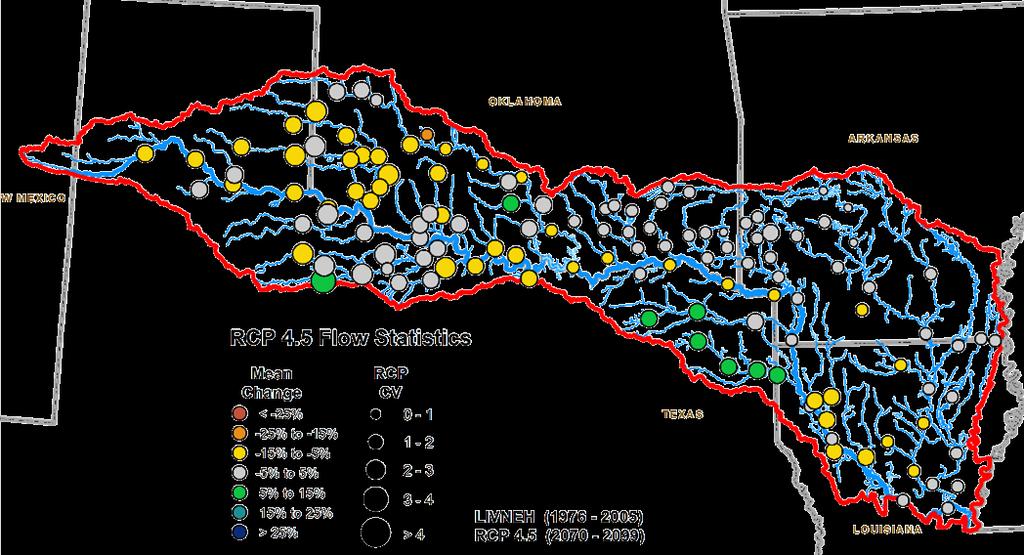
1 Modeling Climate Change in the Red River Basin: Results and Discussion A Presentation To: 2016 RiverWare Users Group Presented By: Cody Hudson, P.E. August 23 rd,

2 Background Funding South Central Climate Science Center Project Timeline Sept to Dec Partners Chickasaw & Choctaw Nations University of Oklahoma 2
3 Method 27 Climate Simulations + 1 Historical 3 Climate Scenarios (RCPs) x 3 GCMs x 3 Downscaling Methods Daily climate output from Runoff Modeling Variable Infiltration Capacity (VIC) Hydrologic Model Climate Data Flows RiverWare Modeling Water Users / Accounting Reservoir Operations Flows Water Availability 3

 shows regions where the projected change is less than one standard")

4 Climate Scenarios Representative Concentration Pathways (RCP) IPCC 5 th Assessment Report RCP 8.5, scenario leading to an increase of 8.5 W/m2 in 2100 Modeled RCP 2.6, 4.5 and 8.5 Hatching (i.e., diagonal lines) shows regions where the projected change is less than one standard deviation of the natural internal variability IPCC, 2013: Summary for Policymakers. In: Climate Change 2013: The Physical Science Basis. Contribution of Working Group I to the Fifth Assessment Report of the Intergovernmental Panel on Climate Change 4
5 Global Climate Models >50 GCMs from 20 research centers used in CMIP5 3 selected that represented area and model uncertainty Model Research Center Resolution CCSM4 U.S. National Center for Atmospheric Research (NCAR) 0.90 x 1.25 MIROC5 University of Tokyo MPI-ESM-LR Max Planck Institute for Meteorology Earth System Model 1.80 x 1.80 NA North America CNA Central North America DJF Dec/Jan/Feb JJA Jun/Jul/Aug Adapted from: Sheffield, J., Barrett, A. P., Colle, B., Nelun Fernando, D., Fu, R., Geil, K. L.,... & Lombardo, K. (2013). North American climate in CMIP5 experiments. Part I: evaluation of historical simulations of continental and regional climatology*. Journal of Climate, 26(23),
6 Downscaling Methods 3 Quantile Mapping Methods CDFt - Cumulative Density Function Transform F LF (x)=f LH (F -1 CH (F CF (x))) EDQM - Equi-Distant Quantile Mapping F LF (x)=cf+ F -1 LH (F CF (x)) - F -1 CH (F CF (x)) BCQM - Bias Correction Quantile Mapping LF= Local Future LH= Local Historical CF= Coarse Future CH=Coarse Historical CDFt without post-processing refinements to improve the tail behavior of the projections Data Link: 6
 Bias Correction of GCM Precipitation by Quantile Mapping: How Well Do Methods Preserve Changes in Quantiles and Extremes?")
7 Future Rainfall (RCP 8.5) 2 LIVNEH ( ) Climate Simulations ( ) mm/yr in./yr Cannon AJ, Sobie SR, Murdock TQ (2015) Bias Correction of GCM Precipitation by Quantile Mapping: How Well Do Methods Preserve Changes in Quantiles and Extremes? Journal of Climate: doi: /jcli-d ) Rainfall Maps generated by Xianwu Xue for this project. 2) Livneh, B. et al., A Long-Term Hydrologically Based Dataset of Land Surface Fluxes and States for the Conterminous United States: Update and Extensions*. Journal of Climate, 26(23):
8 Lake Texoma Inflows from VIC 8
 Developed by Xianwu Xue at University of Oklahoma as part of this project Calibration with daily LIVNEH data")
9 VIC Modeling Macro-Scale Model Solves grid based water balance Inputs Precip., Temp, Wind, Flow Routing multi-site cascading calibration (MSCC) Developed by Xianwu Xue at University of Oklahoma as part of this project Calibration with daily LIVNEH data ( ) Source: 9

10 VIC Calibration 10


")
11 VIC Output Calibration results effected by reservoirs Areas without calibration are suspect Low Baseflow (No Calibration) High Baseflow (Lake Ouachita) No Runoff (Lake Kemp) 11


12 Lake Kemp Monthly Inflows from VIC Lake Kemp 12

13 Red River Compact Splits the basin into 5 reaches Reaches further split into sub-basins Defines water ownership and sets minimum flows 13


14 Accounting in Reach I Compact Oklahoma shall have free and unrestricted use of the water in Subbasin 2 Texas shall have free and unrestricted use of the water in Subbasin 3 Mainstem of the Red River and Lake Texoma. Oklahoma shall be apportioned 200,000 ac-ft/year Texas shall be apportioned 200,000 ac-ft/year. Additional quantities may be apportioned in a ratio of 50% Oklahoma and 50% Texas. Maps provided by: Wayne Kellogg, Environmental Engineer, P.E., P.G., CSP, Chickasaw Nation 14


15 Accounting in Reach I Accounting View Cache Creek (Oklahoma) Red River Wichita River (Texas) 15
 Oklahoma Water Resources")
16 Water Rights (TX & OK) Prior Appropriation Data Sources (TCEQ) Texas Commission on Environmental Quality (OWRB) Oklahoma Water Resources Board 16


17 Water Users >1,500 Water Users!!!! Needed to develop a way to automate script takes water user information in a database and creates objects for import in model Makes Aggregate Diversion and Aggregate Reach Objects Creates links, accounts, sets methods, and slots Data Required Monthly Water Demand Reach Name Water Right Priority Date 17

18 RiverWare Geospatial View 18

19 RCL and Python Used Python to run in Batch Mode using RCL Text files for every object stored in folder for each simulation DMI Input RCP26-CCSM4-EDQM EVAP PREC Det. Inflow Inc. Inflow DMI Output RCP26-CCSM4-EDQM Outflow Storage Elevation Diversion 19


20 Model 5 hrs runtime 30 min. initialization 4 days to run 19 models Computer Specs. 17 Subbasins 353 Water Users >250 AFY 38 Reservoirs 89 Control Points 20

21 Max Flow Scenario 21


22 Flows 22


23 Reservoirs 23
24 Questions? 24
Downscaled Climate Change Projection for the Department of Energy s Savannah River Site
 Downscaled Climate Change Projection for the Department of Energy s Savannah River Site Carolinas Climate Resilience Conference Charlotte, North Carolina: April 29 th, 2014 David Werth Atmospheric Technologies
APPLICATIONS OF DOWNSCALING: HYDROLOGY AND WATER RESOURCES EXAMPLES
 APPLICATIONS OF DOWNSCALING: HYDROLOGY AND WATER RESOURCES EXAMPLES Dennis P. Lettenmaier Department of Civil and Environmental Engineering For presentation at Workshop on Regional Climate Research NCAR
RED RIVER PERIOD OF RECORD UPDATE THRU 2017 FOR USACE- SWD
 RED RIVER PERIOD OF RECORD UPDATE THRU 2017 FOR USACE- SWD Sarah Harris Corps of Engineers, Tulsa District 2018 RW Users Meeting Contributors: Mary Ann Duke, USACE-Tulsa District US Army Corps of Engineers
MULTI MODEL ENSEMBLE FOR ASSESSING THE IMPACT OF CLIMATE CHANGE ON THE HYDROLOGY OF A SOUTH INDIAN RIVER BASIN
 MULTI MODEL ENSEMBLE FOR ASSESSING THE IMPACT OF CLIMATE CHANGE ON THE HYDROLOGY OF A SOUTH INDIAN RIVER BASIN P.S. Smitha, B. Narasimhan, K.P. Sudheer Indian Institute of Technology, Madras 2017 International
Using Multivariate Adaptive Constructed Analogs (MACA) data product for climate projections
 data product for climate projections") Using Multivariate Adaptive Constructed Analogs (MACA) data product for climate projections Maria Herrmann and Ray Najjar Chesapeake Hypoxia Analysis and Modeling Program (CHAMP) Conference Call 2017-04-21
Using Multivariate Adaptive Constructed Analogs (MACA) data product for climate projections Maria Herrmann and Ray Najjar Chesapeake Hypoxia Analysis and Modeling Program (CHAMP) Conference Call 2017-04-21
Climate Dataset: Aitik Closure Project. November 28 th & 29 th, 2018
 1 Climate Dataset: Aitik Closure Project November 28 th & 29 th, 2018 Climate Dataset: Aitik Closure Project 2 Early in the Closure Project, consensus was reached to assemble a long-term daily climate
 http://www.ukm.edu.my/seaclid-cordex/ Addressing future climate change information gaps and data needs in the Southeast Asia region through the Southeast Asia Regional Climate Downscaling (SEACLID)/CORDEX
Hands On Applications of the Latin American and Caribbean Flood and Drought Monitor (LACFDM)
") Hands On Applications of the Latin American and Caribbean Flood and Drought Monitor (LACFDM) Colby Fisher, Eric F Wood, Justin Sheffield, Nate Chaney Princeton University International Training: Application
Hands On Applications of the Latin American and Caribbean Flood and Drought Monitor (LACFDM) Colby Fisher, Eric F Wood, Justin Sheffield, Nate Chaney Princeton University International Training: Application
Using a library of downscaled climate projections to teach climate change analysis
 Using a library of downscaled climate projections to teach climate change analysis Eugene Cordero, Department of Meteorology San Jose State University Overview of Dataset Climate change activity Applications
Climate Projections and Energy Security
 NOAA Research Earth System Research Laboratory Physical Sciences Division Climate Projections and Energy Security Andy Hoell and Jim Wilczak Research Meteorologists, Physical Sciences Division 7 June 2016
INTRODUCTION TO HEC-HMS
 INTRODUCTION TO HEC-HMS Hydrologic Engineering Center- Hydrologic Modeling System US Army Corps of Engineers Hydrologic Engineering Center HEC-HMS Uses Schematics Enter properties: watershed, rivers (reaches),
Regional Climate Change Modeling: An Application Over The Caspian Sea Basin. N. Elguindi and F. Giorgi The Abdus Salam ICTP, Trieste Italy
 Regional Climate Change Modeling: An Application Over The Caspian Sea Basin N. Elguindi and F. Giorgi The Abdus Salam ICTP, Trieste Italy Outline I. Background and historical information on the Caspian
Introduction to Climate Projections and Analysis
 Introduction to Climate Projections and Analysis Jack Katzfey, CSIRO Oceans and Atmosphere 1 June 2016 The project is being implemented by the Asian Development Bank through the technical assistance (TA
Impacts of climate change on flooding in the river Meuse
 Impacts of climate change on flooding in the river Meuse Martijn Booij University of Twente,, The Netherlands m.j.booij booij@utwente.nlnl 2003 in the Meuse basin Model appropriateness Appropriate model
Workshop: Build a Basic HEC-HMS Model from Scratch
 Workshop: Build a Basic HEC-HMS Model from Scratch This workshop is designed to help new users of HEC-HMS learn how to apply the software. Not all the capabilities in HEC-HMS are demonstrated in the workshop
Drought in a Warming Climate: Causes for Change
 Drought in a Warming Climate: Causes for Change Dr. Guiling Wang (guiling.wang@uconn.edu) Department of Civil and Environmental Engineering University of Connecticut Storrs, CT 06269, USA http://hydroclimatology.uconn.edu/
Climate Futures for Eastern Melbourne. Data provided for the Eastern Alliance for Greenhouse Action CSIRO July 2010 (Updated 2013)
") Data provided for the Eastern Alliance for Greenhouse Action CSIRO July 2010 (Updated 2013) 2030 A1B Climate Futures for the 5 grid centred on 37.5 S 146.5 E the 2050s Climate Futures for the 5 grid centred
Data provided for the Eastern Alliance for Greenhouse Action CSIRO July 2010 (Updated 2013) 2030 A1B Climate Futures for the 5 grid centred on 37.5 S 146.5 E the 2050s Climate Futures for the 5 grid centred
Modelling changes in the runoff regime in Slovakia using high resolution climate scenarios
 Modelling changes in the runoff regime in Slovakia using high resolution climate scenarios K. HLAVČOVÁ, R. VÝLETA, J. SZOLGAY, S. KOHNOVÁ, Z. MACUROVÁ & P. ŠÚREK Department of Land and Water Resources
Northern Rockies Adaptation Partnership: Climate Projections
 Northern Rockies Adaptation Partnership: Climate Projections Contents Observed and Projected Climate for the NRAP Region... 2 Observed and Projected Climate for the NRAP Central Subregion... 8 Observed
URBAN DRAINAGE MODELLING
 9th International Conference URBAN DRAINAGE MODELLING Evaluating the impact of climate change on urban scale extreme rainfall events: Coupling of multiple global circulation models with a stochastic rainfall
Climate projections for the Chesapeake Bay and Watershed based on Multivariate Adaptive Constructed Analogs (MACA)
") Climate projections for the Chesapeake Bay and Watershed based on Multivariate Adaptive Constructed Analogs (MACA) Maria Herrmann and Raymond Najjar The Pennsylvania State University Chesapeake Hypoxia
Climate projections for the Chesapeake Bay and Watershed based on Multivariate Adaptive Constructed Analogs (MACA) Maria Herrmann and Raymond Najjar The Pennsylvania State University Chesapeake Hypoxia
Southern New England s Changing Climate. Raymond S. Bradley and Liang Ning Northeast Climate Science Center University of Massachusetts, Amherst
 Southern New England s Changing Climate Raymond S. Bradley and Liang Ning Northeast Climate Science Center University of Massachusetts, Amherst Historical perspective (instrumental data) IPCC scenarios
Projected changes in rainfall and temperature over Greater Horn of Africa (GHA) in different scenarios. In Support of:
 in different scenarios. In Support of:") Projected changes in rainfall and temperature over Greater Horn of Africa (GHA) in different scenarios In Support of: Planning for Resilience in East Africa through Policy, Adaptation, Research, and Economic
Projected changes in rainfall and temperature over Greater Horn of Africa (GHA) in different scenarios In Support of: Planning for Resilience in East Africa through Policy, Adaptation, Research, and Economic
Operational Perspectives on Hydrologic Model Data Assimilation
 Operational Perspectives on Hydrologic Model Data Assimilation Rob Hartman Hydrologist in Charge NOAA / National Weather Service California-Nevada River Forecast Center Sacramento, CA USA Outline Operational
Geophysical Research Letters. Supporting Information for
 1 2 3 4 5 6 7 8 9 1 11 12 13 14 15 16 17 18 19 2 21 22 23 24 25 26 27 28 29 3 Geophysical Research Letters Supporting Information for Identifying sensitive ranges in global warming precipitation change
Reclamation Perspective on Operational Snow Data and Needs. Snowpack Monitoring for Streamflow Forecasting and Drought Planning August 11, 2015
 Reclamation Perspective on Operational Snow Data and Needs Snowpack Monitoring for Streamflow Forecasting and Drought Planning August 11, 2015 2 Reclamation Operational Modeling 3 Colorado Basin-wide Models
Future precipitation in the Central Andes of Peru
 The International Conference on Regional Climate (ICRC)-CORDEX 2016 Future precipitation in the Central Andes of Peru Gustavo De la Cruz 1 Delia Acuña Azarte 1 1 National Meteorology and Hidrology Service
DEVELOPMENT OF A LARGE-SCALE HYDROLOGIC PREDICTION SYSTEM
 JP3.18 DEVELOPMENT OF A LARGE-SCALE HYDROLOGIC PREDICTION SYSTEM Ji Chen and John Roads University of California, San Diego, California ABSTRACT The Scripps ECPC (Experimental Climate Prediction Center)
CWMS Modeling for Real-Time Water Management
 Hydrologic Engineering Center Training Course on CWMS Modeling for Real-Time Water Management August 2018 Davis, California The Corps Water Management System (CWMS) is a software and hardware system to
A PROTOTYPE FOR THE APPLICATION OF CLIMATE INFORMATION TO IMPROVE HIGHWAY AND INFRASTRUCTURE PLANNING IN THE COASTAL REGIONS OF LAKE VICTORIA
 A PROTOTYPE FOR THE APPLICATION OF CLIMATE INFORMATION TO IMPROVE HIGHWAY AND INFRASTRUCTURE PLANNING IN THE COASTAL REGIONS OF LAKE VICTORIA Kara Smith October 26, 2016 Lake Victoria Levels Sudden increase
Numerical Climate Modeling: State-of-the-art, Challenges, and a Program for Latin American and the Caribbean
 Numerical Climate Modeling: State-of-the-art, Challenges, and a Program for Latin American and the Caribbean C. Roberto Mechoso UCLA Numerical modeling is a mainstay of any modern activity in climate prediction
End-to-end Demonstrator for improved decision making in the water sector in Europe (EDgE)
") End-to-end Demonstrator for improved decision making in the water sector in Europe (EDgE) Deliverable D2.2a Interim report on end to end modelling chain using observed climate Issued by: UFZ, CPL Date:
End-to-end Demonstrator for improved decision making in the water sector in Europe (EDgE) Deliverable D2.2a Interim report on end to end modelling chain using observed climate Issued by: UFZ, CPL Date:
Operational Hydrologic Ensemble Forecasting. Rob Hartman Hydrologist in Charge NWS / California-Nevada River Forecast Center
 Operational Hydrologic Ensemble Forecasting Rob Hartman Hydrologist in Charge NWS / California-Nevada River Forecast Center Mission of NWS Hydrologic Services Program Provide river and flood forecasts
Developing a High-Resolution Texas Water and Climate Prediction Model
 Developing a High-Resolution Texas Water and Climate Prediction Model Zong-Liang Yang (512) 471-3824 liang@jsg.utexas.edu Water Forum II on Texas Drought and Beyond, Austin, Texas, 22-23 October, 2012
Study 16.5 Probable Maximum Flood (PMF)
") Initial Study Report Meeting Study 16.5 Probable Maximum Flood (PMF) March 30, 2016 Prepared by 3/30/2016 1 Study 16.5 Status ISR documents (ISR Part D Overview): Status: Initial Study Report: Parts A,
Initial Study Report Meeting Study 16.5 Probable Maximum Flood (PMF) March 30, 2016 Prepared by 3/30/2016 1 Study 16.5 Status ISR documents (ISR Part D Overview): Status: Initial Study Report: Parts A,
Impact Assessment of Climate Change on Water-Related Disasters for Building Up an Adaptation Strategy
 Impact Assessment of Climate Change on Water-Related Disasters for Building Up an Adaptation Strategy Yasuto TACHIKAWA Hydrology and Water Resources Research Lab. Dept. of Civil & Earth Resources Engineering,
INVESTIGATING THE SIMULATIONS OF HYDROLOGICAL and ENERGY CYCLES OF IPCC GCMS OVER THE CONGO AND UPPER BLUE NILE BASINS
 INVESTIGATING THE SIMULATIONS OF HYDROLOGICAL and ENERGY CYCLES OF IPCC GCMS OVER THE CONGO AND UPPER BLUE NILE BASINS Mohamed Siam, and Elfatih A. B. Eltahir. Civil & Environmental Engineering Department,
Training: Climate Change Scenarios for PEI. Training Session April Neil Comer Research Climatologist
 Training: Climate Change Scenarios for PEI Training Session April 16 2012 Neil Comer Research Climatologist Considerations: Which Models? Which Scenarios?? How do I get information for my location? Uncertainty
(c) (a) (d) (b) JJA DJF. V850 Hulu Cave. V850 Hulu Cave V1000 V1000. Dongge Cave. Dongge Cave. Lake Huguang Maar.
 (a) (d) (b) JJA DJF. V850 Hulu Cave. V850 Hulu Cave V1000 V1000. Dongge Cave. Dongge Cave. Lake Huguang Maar.") NCEP-DOE (1981-2010) TraCE21ka (a) (c) JJA Dongge Cave V850 Hulu Cave Dongge Cave V850 Hulu Cave (b) (d) DJF Lake Huguang Maar V1000 Lake Huguang Maar V1000 Supplementary Figure 1 Climatology of EASM and
NCEP-DOE (1981-2010) TraCE21ka (a) (c) JJA Dongge Cave V850 Hulu Cave Dongge Cave V850 Hulu Cave (b) (d) DJF Lake Huguang Maar V1000 Lake Huguang Maar V1000 Supplementary Figure 1 Climatology of EASM and
A downscaling and adjustment method for climate projections in mountainous regions
 A downscaling and adjustment method for climate projections in mountainous regions applicable to energy balance land surface models D. Verfaillie, M. Déqué, S. Morin, M. Lafaysse Météo-France CNRS, CNRM
DRAFT. REVISED Draft. Paso Robles Subbasin Groundwater Sustainability Plan Chapter 6
 REVISED Draft Paso Robles Subbasin Groundwater Sustainability Plan Chapter 6 Prepared for the Paso Robles Subbasin Cooperative Committee and the Groundwater Sustainability Agencies February 14, 2019 Paso
Modeling the Effects of Climate and Land Cover Change in the Stoney Brook Subbasin of the St. Louis River Watershed
 Modeling the Effects of Climate and Land Cover Change in the Stoney Brook Subbasin of the St. Louis River Watershed Joe Johnson and Jesse Pruette 214 NASA Research Internship Geospatial Technologies Program
Drought Monitoring with Hydrological Modelling
 st Joint EARS/JRC International Drought Workshop, Ljubljana,.-5. September 009 Drought Monitoring with Hydrological Modelling Stefan Niemeyer IES - Institute for Environment and Sustainability Ispra -
The Projection of Temperature and Precipitation over Bangladesh under RCP Scenarios using CMIP5 Multi-Model Ensemble
 Paper ID: WRE-37 International Conference on Recent Innovation in Civil Engineering for Sustainable Development (IICSD-5) Department of Civil Engineering DUET - Gazipur, Bangladesh The Projection of Temperature
Chiang Rai Province CC Threat overview AAS1109 Mekong ARCC
 Chiang Rai Province CC Threat overview AAS1109 Mekong ARCC This threat overview relies on projections of future climate change in the Mekong Basin for the period 2045-2069 compared to a baseline of 1980-2005.
NetCDF, NCAR s climate model data, and the IPCC. Gary Strand NCAR/NESL/CGD
 NetCDF, NCAR s climate model data, and the IPCC Gary Strand NCAR/NESL/CGD NCAR s climate model data A bit of history... 1960s - 1990s Self-designed self-implemented binary formats 1990s-2000s netcdf-3
WHAT DO WE KNOW ABOUT FUTURE CLIMATE IN COASTAL SOUTH CAROLINA?
 WHAT DO WE KNOW ABOUT FUTURE CLIMATE IN COASTAL SOUTH CAROLINA? Amanda Brennan & Kirsten Lackstrom Carolinas Integrated Sciences & Assessments November 13, 2013 Content Development Support: Greg Carbone
Regional Drought and Crop Yield Information System to enhance drought monitoring and forecasting in Lower Mekong region
 Regional Drought and Crop Yield Information System to enhance drought monitoring and forecasting in Lower Mekong region Asian Disaster Preparedness Center/SERVIR-Mekong 2 Anticipated Results Improved capacity
Production and use of CORDEX projections a Swedish perspective on building climate services in practice
 Production and use of CORDEX projections a Swedish perspective on building climate services in practice Erik Kjellström 1, Lars Bärring 1, Grigory Nikulin 1, Carin Nilsson 2, Gustav Strandberg 1 1 Rossby
Ramesh Vellore. CORDEX Team: R. Krishnan, T.P. Sabin, J. Sanjay, Milind Mujumdar, Sandip Ingle, P. Priya, M.V. Rama Rao, and Madhura Kane
 Ramesh Vellore CORDEX Team: R. Krishnan, T.P. Sabin, J. Sanjay, Milind Mujumdar, Sandip Ingle, P. Priya, M.V. Rama Rao, and Madhura Kane Centre for Climate Change Research Indian Institute of Tropical
Climate Change Scenarios in Southern California. Robert J. Allen University of California, Riverside Department of Earth Sciences
 Climate Change Scenarios in Southern California Robert J. Allen University of California, Riverside Department of Earth Sciences Overview Climatology of Southern California Temperature and precipitation
USA National Weather Service Community Hydrologic Prediction System
 USA National Weather Service Community Hydrologic Prediction System Rob Hartman Hydrologist in Charge NOAA / National Weather Service California-Nevada River Forecast Center Sacramento, CA Background Outline
Contents of this file
 Geophysical Research Letters Supporting Information for Future changes in tropical cyclone activity in high-resolution large-ensemble simulations Kohei Yoshida 1, Masato Sugi 1, Ryo Mizuta 1, Hiroyuki
The Texas drought. Kingtse Mo Climate Prediction Center NWS/NCEP/NOAA
 The 2011-2012 Texas drought Kingtse Mo Climate Prediction Center NWS/NCEP/NOAA 1 outline Evolution of the 2011-2012 Texas drought Climatology and historical perspective The 2011 drought Onset Feedback
Twenty-first-century projections of North Atlantic tropical storms from CMIP5 models
 SUPPLEMENTARY INFORMATION DOI: 10.1038/NCLIMATE1530 Twenty-first-century projections of North Atlantic tropical storms from CMIP5 models SUPPLEMENTARY FIGURE 1. Annual tropical Atlantic SST anomalies (top
Regionalización dinámica: la experiencia española
 Regionalización dinámica: la experiencia española William Cabos Universidad de Alcalá de Henares Madrid, Spain Thanks to: D. Sein M.A. Gaertner J. P. Montávez J. Fernández M. Domínguez L. Fita M. García-Díez
Climate Summary for the Northern Rockies Adaptation Partnership
 Climate Summary for the Northern Rockies Adaptation Partnership Compiled by: Linda Joyce 1, Marian Talbert 2, Darrin Sharp 3, John Stevenson 4 and Jeff Morisette 2 1 USFS Rocky Mountain Research Station
Climate predictability beyond traditional climate models
 Climate predictability beyond traditional climate models Rasmus E. Benestad & Abdelkader Mezghani Rasmus.benestad@met.no More heavy rain events? More heavy rain events? Heavy precipitation events with
9. PROBABLE MAXIMUM PRECIPITATION AND PROBABLE MAXIMUM FLOOD
 9. PROBABLE MAXIMUM PRECIPITATION AND PROBABLE MAXIMUM FLOOD 9.1. Introduction Due to the size of Watana Dam and the economic importance of the Project to the Railbelt, the Probable Maximum Flood (PMF)
TRENDS AND CHANGE IN CLIMATE OVER THE VOLTA RIVER BASIN
 TRENDS AND CHANGE IN CLIMATE OVER THE VOLTA RIVER BASIN VOLTRES PROJECT WORK PACKAGE 1a: CLIMATE KEY RESULTS E. Obuobie, H.E. Andersen, C. Asante-Sasu, M. Osei-owusu 11/9/217 OBJECTIVES Analyse long term
Operational water balance model for Siilinjärvi mine
 Operational water balance model for Siilinjärvi mine Vesa Kolhinen, Tiia Vento, Juho Jakkila, Markus Huttunen, Marie Korppoo, Bertel Vehviläinen Finnish Environment Institute (SYKE) Freshwater Centre/Watershed
Annex I to Target Area Assessments
 Baltic Challenges and Chances for local and regional development generated by Climate Change Annex I to Target Area Assessments Climate Change Support Material (Climate Change Scenarios) SWEDEN September
Climate Change Adaptation for ports and navigation infrastructure
 Climate Change Adaptation for ports and navigation infrastructure The application of climate projections and observations to address climate risks in ports Iñigo Losada Research Director IHCantabria Universidad
Study 16.5 Probable Maximum Flood (PMF)
") Initial Study Report Meeting Study 16.5 Probable Maximum Flood (PMF) October 22, 2014 Prepared by 10/22/2014 1 Study 16.5 Objectives Develop a site-specific PMP to be used for the derivation of the PMF
Initial Study Report Meeting Study 16.5 Probable Maximum Flood (PMF) October 22, 2014 Prepared by 10/22/2014 1 Study 16.5 Objectives Develop a site-specific PMP to be used for the derivation of the PMF
Supplementary Information for:
 Supplementary Information for: Linkage between global sea surface temperature and hydroclimatology of a major river basin of India before and after 1980 P. Sonali, Ravi S. Nanjundiah, & D. Nagesh Kumar
Appendix D. Model Setup, Calibration, and Validation
 . Model Setup, Calibration, and Validation Lower Grand River Watershed TMDL January 1 1. Model Selection and Setup The Loading Simulation Program in C++ (LSPC) was selected to address the modeling needs
8-km Historical Datasets for FPA
 Program for Climate, Ecosystem and Fire Applications 8-km Historical Datasets for FPA Project Report John T. Abatzoglou Timothy J. Brown Division of Atmospheric Sciences. CEFA Report 09-04 June 2009 8-km
Experiments with Statistical Downscaling of Precipitation for South Florida Region: Issues & Observations
 Experiments with Statistical Downscaling of Precipitation for South Florida Region: Issues & Observations Ramesh S. V. Teegavarapu Aneesh Goly Hydrosystems Research Laboratory (HRL) Department of Civil,
CLIMATE MODEL DOWNSCALING: HOW DOES IT WORK AND WHAT DOES IT TELL YOU?
 rhgfdjhngngfmhgmghmghjmghfmf CLIMATE MODEL DOWNSCALING: HOW DOES IT WORK AND WHAT DOES IT TELL YOU? YAN FENG, PH.D. Atmospheric and Climate Scientist Environmental Sciences Division Argonne National Laboratory
ON IMPROVING ENSEMBLE FORECASTING OF EXTREME PRECIPITATION USING THE NWS METEOROLOGICAL ENSEMBLE FORECAST PROCESSOR (MEFP)
") ON IMPROVING ENSEMBLE FORECASTING OF EXTREME PRECIPITATION USING THE NWS METEOROLOGICAL ENSEMBLE FORECAST PROCESSOR (MEFP) Dong-Jun Seo 1, James Brown 2, Theresa Modrick 3, Konstantine Georgakakos 3, Sunghee
ON IMPROVING ENSEMBLE FORECASTING OF EXTREME PRECIPITATION USING THE NWS METEOROLOGICAL ENSEMBLE FORECAST PROCESSOR (MEFP) Dong-Jun Seo 1, James Brown 2, Theresa Modrick 3, Konstantine Georgakakos 3, Sunghee
Climate Change and the Chehalis River. Guillaume Mauger, Se-Yeun Lee, Christina Bandaragoda, Yolande Serra, and Jason Won September 21, 2016
 Climate Change and the Chehalis River Guillaume Mauger, Se-Yeun Lee, Christina Bandaragoda, Yolande Serra, and Jason Won September 21, 2016 Background: General Approach to Climate Impacts Assessment Global
Forecast Methods, Products, and Services for the San Joaquin River Basin. Mission of NWS Hydrologic Services Program
 NOAA s s National Weather Service California-Nevada River Forecast Center Forecast Methods, Products, and Services for the San Joaquin River Basin Rob Hartman Hydrologist in Charge Mission of NWS Hydrologic
CARFFG System Development and Theoretical Background
 CARFFG Steering Committee Meeting 15 SEPTEMBER 2015 Astana, KAZAKHSTAN CARFFG System Development and Theoretical Background Theresa M. Modrick, PhD Hydrologic Research Center Key Technical Components -
SEACLID/CORDEX Southeast Asia: A Regional Initiative to Provide Regional Climate Change Information and Capacity Building
 SEACLID/CORDEX Southeast Asia: A Regional Initiative to Provide Regional Climate Change Information and Capacity Building Liew Ju Neng SEACLID/CORDEX Southeast Asia School of Environment and Natural Sciences
Muhammad Noor* & Tarmizi Ismail
 Malaysian Journal of Civil Engineering 30(1):13-22 (2018) DOWNSCALING OF DAILY AVERAGE RAINFALL OF KOTA BHARU KELANTAN, MALAYSIA Muhammad Noor* & Tarmizi Ismail Department of Hydraulic and Hydrology, Faculty
Supplementary Figure 1 Current and future distribution of temperate drylands. (a b-f b-f
 Supplementary Figure 1 Current and future distribution of temperate drylands. (a) Five temperate dryland regions with their current extent for 1980-2010 (green): (b) South America; (c) North America; (d)
Adaptation for global application of calibration and downscaling methods of medium range ensemble weather forecasts
 Adaptation for global application of calibration and downscaling methods of medium range ensemble weather forecasts Nathalie Voisin Hydrology Group Seminar UW 11/18/2009 Objective Develop a medium range
Desert Amplification in a Warming Climate
 Supporting Tables and Figures Desert Amplification in a Warming Climate Liming Zhou Department of Atmospheric and Environmental Sciences, SUNY at Albany, Albany, NY 12222, USA List of supporting tables
Valenciano Reservoir Safe Yield Study. Prepared by: CSA Architects & Engineers, LLP
 Valenciano Reservoir Safe Yield Study Prepared by: CSA Architects & Engineers, LLP CSA Group Prepared for: Puerto Rico Aqueduct and Sewer Authority Planning TABLE OF CONTENTS 1 Introduction...1 1.1 Safe
Assessing climate change impacts on the water resources in Pune, India, using downscaling and hydrologic modeling
 Assessing climate change impacts on the water resources in Pune, India, using downscaling and hydrologic modeling 1, Tim G. Reichenau 1, Shamita Kumar 2, Karl Schneider 1 1 Hydrogeography and Climatology
Leon Creek Watershed October 17-18, 1998 Rainfall Analysis Examination of USGS Gauge Helotes Creek at Helotes, Texas
 Leon Creek Watershed October 17-18, 1998 Rainfall Analysis Examination of USGS Gauge 8181400 Helotes Creek at Helotes, Texas Terrance Jackson MSCE Candidate University of Texas San Antonio Abstract The
Subproject 01 Climate Change in the Okavango region
 Subproject 01 Climate Change in the Okavango region THE FUTURE OKAVANGO PROJECT General meeting 10. 13. October 2011 Maun-Lodge, Maun, Botswana Dr. Torsten Weber, Prof. Dr. Daniela Jacob Climate Service
China s contribution to Indus Forum (2013-): Changes of observation and projection in climate, runoff and flood/drought over Indus River Basin
: Changes of observation and projection in climate, runoff and flood/drought over Indus River Basin") China s contribution to Indus Forum (2013-): Changes of observation and projection in climate, runoff and flood/drought over Indus River Basin Jiang Tong, Xu Hongmei, Li Xiucang, NCC/CMA Zhao Chengyi,
China s contribution to Indus Forum (2013-): Changes of observation and projection in climate, runoff and flood/drought over Indus River Basin Jiang Tong, Xu Hongmei, Li Xiucang, NCC/CMA Zhao Chengyi,
Future population exposure to US heat extremes
 Outline SUPPLEMENTARY INFORMATION DOI: 10.1038/NCLIMATE2631 Future population exposure to US heat extremes Jones, O Neill, McDaniel, McGinnis, Mearns & Tebaldi This Supplementary Information contains additional
Multi-model approach for projecting future climate change conditions in Central Vietnam
 2011/03/03 at the ICSS-Asia 2011 conference Multi-model approach for projecting future climate change conditions in Central Vietnam Thanh NGO-DUC, Van Tan PHAN, Trung NGUYEN QUANG Department of Meteorology
NRC Workshop Probabilistic Flood Hazard Assessment (PFHA) Jan 29-31, Mel Schaefer Ph.D. P.E. MGS Engineering Consultants, Inc.
 Jan 29-31, Mel Schaefer Ph.D. P.E. MGS Engineering Consultants, Inc.") Stochastic Event Flood Model (SEFM) Stochastic Modeling of Extreme Floods A Hydrological Tool for Analysis of Extreme Floods Mel Schaefer Ph.D. P.E. MGS Engineering Consultants, Inc. Olympia, WA NRC Workshop
Stochastic Event Flood Model (SEFM) Stochastic Modeling of Extreme Floods A Hydrological Tool for Analysis of Extreme Floods Mel Schaefer Ph.D. P.E. MGS Engineering Consultants, Inc. Olympia, WA NRC Workshop
North American Regional Climate Change Assessment Program
 North American Regional Climate Change Assessment Program Toni Rosati IMAGe NCAR narccap@ucar.edu Outline Basic concepts of numerical climate modeling NetCDF data format overview NARCCAP project NARCCAP
Quantifying Uncertainty in Modelled Estimates of Future Extreme Precipitation Events CFCAS Project Progress Report
 Quantifying Uncertainty in Modelled Estimates of Future Extreme Precipitation Events CFCAS Project Progress Report The University of Western Ontario Outline A - Reanalysis Data for UTRW C Quantifying GCM
Canadian Climate Data and Scenarios (CCDS) ccds-dscc.ec.gc.ca
 ccds-dscc.ec.gc.ca") Canadian Climate Data and Scenarios (CCDS) ccds-dscc.ec.gc.ca Benita Tam Canadian Centre for Climate Modelling and Analysis (CCCma) Climate Research Division (CRD), Science and Technology Branch Environment
Canadian Climate Data and Scenarios (CCDS) ccds-dscc.ec.gc.ca Benita Tam Canadian Centre for Climate Modelling and Analysis (CCCma) Climate Research Division (CRD), Science and Technology Branch Environment
QUANTIFYING CHANGES IN EXTREME PRECIPITATION AT HOUSTON AND OKLAHOMA CITY BY USING THE CANADIAN REGIONAL CLIMATE MODEL (CRCM)
") QUANTIFYING CHANGES IN EXTREME PRECIPITATION AT HOUSTON AND OKLAHOMA CITY BY USING THE CANADIAN REGIONAL CLIMATE MODEL (CRCM) Daniel J. Brouillette 1, Yang Hong 2, Lu Liu 2 1 National Weather Center Research
QUANTIFYING CHANGES IN EXTREME PRECIPITATION AT HOUSTON AND OKLAHOMA CITY BY USING THE CANADIAN REGIONAL CLIMATE MODEL (CRCM) Daniel J. Brouillette 1, Yang Hong 2, Lu Liu 2 1 National Weather Center Research
TRWD Upper Trinity River Flood Operations Decision Support System
 TRWD Upper Trinity River Flood Operations Decision Support System TFMA 2012 Fall Conference Rockwall, Texas September 20, 2012 Presented by: Andrew Ickert, PE, CFM & Craig Ottman, PE, CFM (Halff Associates,
Satellite data for hydrological forecasting
 Satellite data for hydrological forecasting Current use at ECMWF and perspective Shopping list! Our current tools does not allow direct use, but could be modified Christel Prudhomme Christel.prudhomme@ecmwf.int
Relevant EU-projects for the hydropower sector: IMPREX and S2S4E
 Coupled atmospheric ocean land GCM (CGCM) Downscaling & Bias Adjustment Impact models (e.g. hydrology) Decision makers Community Ilias Pechlivanidis (Hydrology Research) David Gustafsson (Hydrology Research)
Current and Future Plans. R. Srinivasan
 Current and Future Plans R. Srinivasan Contents 1 The ArcSWAT Interface 2 VizSWAT: Output Visualization 3 User online support 4 MapWindows SWAT interface 5 ArcGIS SWAT/APEX interfaces 6 Radar Rainfall
More extreme precipitation in the world s dry and wet regions
 More extreme precipitation in the world s dry and wet regions Markus G. Donat, Andrew L. Lowry, Lisa V. Alexander, Paul A. O Gorman, Nicola Maher Supplementary Table S1: CMIP5 simulations used in this
1990 Intergovernmental Panel on Climate Change Impacts Assessment
 1990 Intergovernmental Panel on Climate Change Impacts Assessment Although the variability of weather and associated shifts in the frequency and magnitude of climate events were not available from the
 Western US Stream Flow Metric Dataset: Modeled Flow Metrics for Stream Segments in Selected Basins of the Western United States under Historical Conditions and Forecast Climate Change Scenarios Dataset
Changing Hydrology under a Changing Climate for a Coastal Plain Watershed
 Changing Hydrology under a Changing Climate for a Coastal Plain Watershed David Bosch USDA-ARS, Tifton, GA Jeff Arnold ARS Temple, TX and Peter Allen Baylor University, TX SEWRU Objectives 1. Project changes
How to integrate wetland processes in river basin modeling? A West African case study
 How to integrate wetland processes in river basin modeling? A West African case study stefan.liersch@pik-potsdam.de fred.hattermann@pik-potsdam.de June 2011 Outline Why is an inundation module required?
BUREAU OF METEOROLOGY
 BUREAU OF METEOROLOGY Building an Operational National Seasonal Streamflow Forecasting Service for Australia progress to-date and future plans Dr Narendra Kumar Tuteja Manager Extended Hydrological Prediction